Abstract
The transition of nations to renewable energy sources is a fact, and the deployment of renewable energy (RE) projects has increased in the last decades. The deployment of energy projects in uninhabited islets (islands) provides a promising opportunity for low-carbon energy transition. Considering the importance of the spatial dimension of RE projects, in this research, we identified and ranked uninhabited islets (UIs) for wind farm deployment in the South Aegean Sea, Greece. The proposed methodology combines geographic information systems (GIS) and two multicriteria analysis methods (AHP and TOPSIS) using some restrictions found in Greek law as well as assessment criteria considering environmental, economic, and technical aspects. The appropriate UIs were then ranked under four different policy scenarios (baseline, equal criteria weights, a policy scenario oriented to technical/economic criteria, and a policy scenario focusing on environmental criteria). The results indicated the existence of three UIs for siting wind farms in the region of the South Aegean, with the same ranking of these UIs under different scenarios. The proposed methodology provides useful guidelines for selecting UIs as wind farm sites in Greece and could be applied in other countries worldwide.
1. Introduction
The deployment of renewable energy technologies and the promotion of green energy have been widely recognized as a means of achieving independence from fuel oil on a global scale. Traditional coal-fired power facilities should disappear in the next years as part of the decarbonization transition. In this perspective, renewable energy sources represent a unique energy supply solution. The natural environment provides green energy, and wind energy is one of the most frequently used and constantly evolving sources of renewable energy. Although onshore wind energy technology is more advanced than offshore technology, there has been a growing tendency towards the construction of offshore wind farms during the last few years.
Methodologies for siting both onshore and offshore wind farms using geographic information systems (GIS) and multicriteria decision-making (MCDM) methods have been frequently described in the recent literature [1,2,3,4,5,6,7,8,9,10,11,12,13,14,15,16,17]. GIS provides thematic maps that include exclusion and/or evaluation criteria for a given case study. In addition, several MCDM methods such as Analytical Hierarchy Process (AHP), the Analytic Network Process (ANP), the Technique for Order Preference by Similarity to Ideal Solution (TOPSIS), Višekriterijumsko Kompromisno Rangiranje (VIKOR), Élimination et Choix Traduisant la Réalité (ELECTRE), and the Preference Ranking Organization Method for Enrichment Evaluations (PROMETHEE) have been applied to solve multicriteria problems, such as the sustainable siting of wind farms.
Insular areas have specific characteristics compared to land environments, and the most important of these are as follows [18]: (i) land scarcity due to the fact that all activities and infrastructure should be contained on the island, (ii) the land’s heterogeneity often prevents the deployment of solar and wind energy projects, (iii) fluctuations in energy consumption that occur during the peak season, and (iv) electric submarine interconnectivity is a difficult and demanding issue. However, numerous studies can be found in the literature regarding the siting of wind farms on islands.
Tegou et al. [19] created an integrated framework for determining the best locations for wind farm installation on the Greek island of Lesvos (an electricity-independent island). In the analysis, several constraints imposed by national legislation were considered, and the study area was evaluated using various technical, economic, environmental, and social criteria to identify the most economically viable, environmentally friendly, technically practicable, and socially acceptable areas. In the context of AHP, the weights of these criteria were computed using pairwise comparisons, and the weighted sum of the criteria yielded an integrated suitability map for the study region. The results defined the optimum sites for wind projects, excluding almost half of the research area, with the highest-scoring areas covering only 1.4% of the island’s surface. Panagiotidou et al. [20] identified the most preferable locations for WF installation in environmental terms in the Dodecanese Islands of Greece. AHP, GIS, and remote sensing satellite images and data analysis methods were combined for the needs of the study. According to the overlapping processes used to create the overall suitability map, approximately 23.4% of the area was appropriate for WF siting. Bertsiou et al. [21] developed a combined GIS–AHP method for evaluating eligible areas for wind farm projects for different combinations of six criteria (wind potential, altitude, settlements, road network, telecommunication sites, and archaeological sites) and applied their methodology to Fournoi Korseon Island in the Aegean Sea, Greece. The unsuitable area covered 27.9% of the total land area, and different suitability maps were created through a sensitivity analysis. Feloni and Karandinaki [22] developed and applied a multicriteria decision-making (MCDM)-based methodology for determining acceptable sites for wind farm deployment in the regional unit of Chania, Crete, Aegean Sea, Greece. GIS analysis was combined with MCDM approaches, both for the criterion weighting process and for the classification of their values in a common scale. The result of MCDM was a suitability map, which ranked the areas from unsuitable sites to extremely appropriate sites.
Although there is a vast body of literature on wind farm siting in insular areas, to the best of the authors’ knowledge, this is the first attempt at wind farm siting in uninhabited islets (UIs) and extends the existing literature on onshore and offshore wind farm siting, since the sitting process for UIs could take advantage of the experience and expertise on onshore wind farms on the one hand and, on the other, could exploit the advantages of offshore wind farms such as the consistent wind flow of insular areas, the mitigation of potential land use conflicts, and the elimination of noise produced that could affect nearby communities [23]. The property status of the study area was also examined for the first time in renewable energy siting studies; therefore, all rocky islets that are private were excluded from the analysis. Since there is a gap in the siting criteria in this spatial category (uninhabited islets), a set of criteria is proposed and applied, covering various aspects (e.g., environmental, technical, and safety) in both the exclusion and assessment phases. It should be noted that the specific focus is on the natural and the cultural environment. The exploitation of UIs for the deployment of renewable energy sources could serve as an asset for decision and policymakers.
In this study, an integrated framework for identifying the most preferable UIs in the South Aegean region of Greece for deploying wind farms was applied and presented. GIS and MCDM were combined in the proposed framework. Unsuitable UIs for the deployment of wind farm projects were determined using the restrictions of Greek legislation, and a GIS database was created with thematic maps related to the aforementioned constraints. Eligible UIs that were not excluded by these restrictions and constraints were then evaluated and ranked using the AHP and TOPSIS methods, and by considering a set of assessment criteria related to technical, economic, and environmental aspects. Finally, the most suitable areas for wind farm deployment in UIs in the South Aegean region were defined. The methodology developed in this study provides an effective decision support tool for planners, academics, investors, and policymakers.
The remainder of this study includes the following sections: Section 2 describes the methodological framework of the wind farm siting assessment applied in this study, defining both the exclusion and the assessment criteria, as well as the data used. In Section 3, the results of the study are presented and discussed, whereas Section 4 presents the main conclusions of this study.
2. Materials and Methods
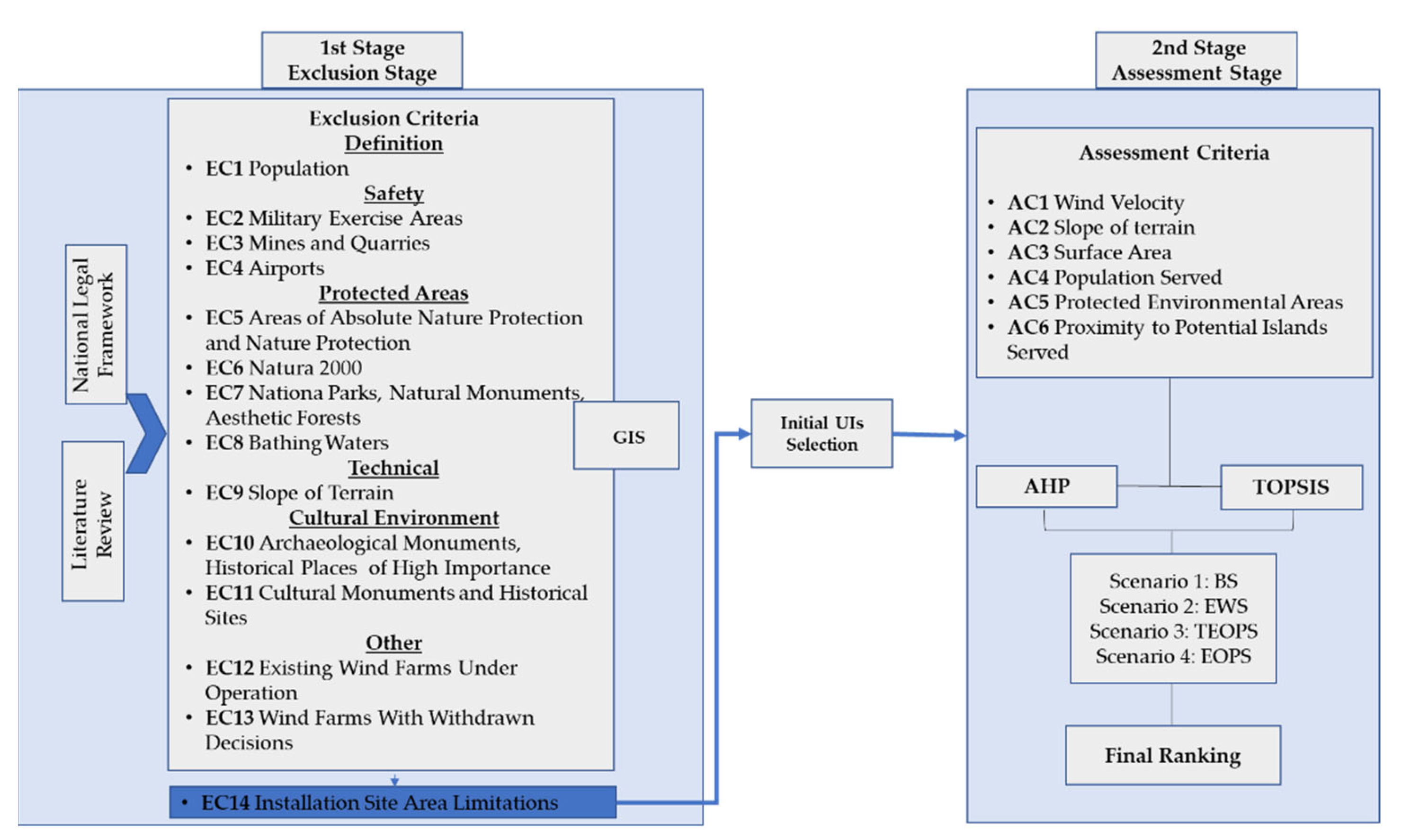
The methodological framework depicted in Figure 1 was applied to determine the most appropriate UIs in the region of the South Aegean, Greece, for the deployment of wind farm projects. The framework combines the use of GIS and MCDM methods (AHP and TOPSIS) and is divided into two distinct stages. The first stage (the exclusion stage) attempts to exclude UIs that are unsuitable for wind farm siting and, as a result, to identify eligible UIs that will be evaluated further in the second stage (the assessment stage). Individual thematic maps depicting various exclusion criteria such as the definition of UIs, safety, protected areas, the cultural environment, and others were created for this purpose using a GIS database. Inappropriate UIs were defined by overlapping the abovementioned maps, whereas the other UIs represent areas where wind farms could be deployed and are further evaluated in the second stage. AHP is applied in the second stage of the proposed methodology (the assessment stage) to determine the relative weights of six assessment criteria (AC1–AC6). Pairwise comparisons of the AC were performed based on: (i) the baseline scenario according to authors’ expertise (Scenario 1: BS), (ii) equal criterion weights (Scenario 2: EWS), (iii) a technical–economic-oriented policy scenario (Scenario 3: TEOPS), and (iv) an environmentally oriented policy scenario (Scenario 4: EOPS). The eligible UIs from the first stage are assessed and ranked using the TOPSIS method, and the most appropriate uninhabited island for wind farm siting in the region of South Aegean (Greece) is finally selected under the four different scenarios.
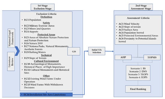
Figure 1.
Methodological framework for wind farm deployment on UIs in the South Aegean region of Greece.
2.1. Study Area
The region of the South Aegean consists of two large island groups, the Cyclades and the Dodecanese, and is located at the southeastern edge of Greece (Figure 2). The region has a total area of 5286 km2, accounts for 4% of the total area of the country, and includes numerous islands.
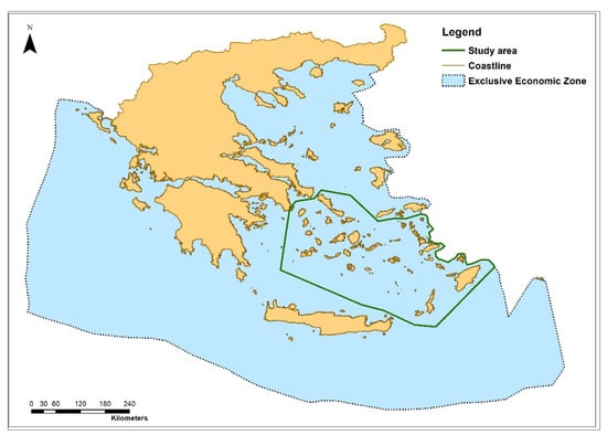
Figure 2.
Definition of the study area.
According to the Fourth Intergovernmental Panel on Climate Change (IPCC), the region of the South Aegean is among the areas that have been characterized as vulnerable to climate change [24]. According to the latest census of the statistical service of Greece (2011), the South Aegean area consists of 13 regional units and 33 municipalities, while the permanent population of the South Aegean comprises almost 309,015 permanent residents [25]. Εach regional unit and each municipality consists of inhabited islands and uninhabited rocky islets. Most of the inhabited islands share the same geological and cultural characteristics, but in terms of topography, local customs, and tourist development, each island has its own individual character. The tertiary sector is the most productive sector of the region, due to tourism, while other industries that exist in the marine area of the study area include navigation, aquaculture, and fisheries.
The wind velocity in the islands ranges from 7 m/s up to 20 m/s, with the latter prevailing in many islands of the study area. A significant part of the region of Cyclades and the Dodecanese is of high ecological importance, as it consists of 31 areas integrated in Natura 2000, 39 CORINE biotopes, and a considerable number of wetlands.
In this study, we focused on the uninhabited islets that exist in the area in order to overcome the space limitations that exist in the inhabited islands, while exploiting the high wind potential that prevails in the area due to its geographical location. It should be noted that all rocky islets that are private or volcanic were excluded from the analysis.
2.2. Selection Criteria and Data Sources
2.2.1. Exclusion Criteria and Data Sources
The appropriate UIs for this location were determined using GIS and by excluding areas that were subject to particular restrictions and constraints listed either in the Greek legal document related to the spatial planning of renewable energy sources (RES) (Specific Framework for Spatial Planning and Sustainable Development for Renewable Energy Sources (SFSPSD-RES)) [26] and/or in the international literature (Table 1).

Table 1.
Exclusion criteria for the deployment of wind farm projects in UIs in the region of the South Aegean, Greece.
After defining all of these restrictions, data were gathered in order to create the relevant thematic maps in GIS. Several datasets linked to these constraints were collected either in vector or raster format, while others were obtained in raw format and digitized accordingly using GIS.
With regard to the data sources, in the case of the population (EC1); airports (EC4); Natura 2000 (EC6); national parks, natural monuments, and aesthetic forests (EC7) criteria, spatial information was acquired from datasets found in [30], while data about military exercise areas (EC2), and mines and quarries (EC3) were obtained from the Hellenic Navy Hydrographic Service ([31,32], respectively). Regarding areas of absolute nature protection and nature protection (EC5), bathing waters (EC8), and the slope of the terrain (EC9), data were retrieved from the Greek Biotope/Wetland Centre (EKBY) ([33,34,35] respectively). Information about archaeological monuments, historical places of high importance (EC10), and cultural monuments and historical sites (EC11) was retrieved from the databases of [36], while data regarding proposed wind farm projects (EC12 and EC13) were retrieved from the Greek Regulatory Authority for Energy [37].
2.2.2. Assessment Criteria
There are numerous assessment criteria in the international literature for the location of onshore [38,39,40,41,42] and offshore [43,44,45,46,47] wind farms. In this study, we used six (6) assessment criteria regarding the economic, technical, and environmental aspects (Table 2).
Table 2.
Assessment criteria for wind farm siting on UIs in the region of the South Aegean, Greece.
In terms of AC1 and AC2, the available wind potential and the slope of the terrain are important to a wind farm project’s economic viability and technological feasibility. It is obvious that the most preferable locations are those with the highest WV and the lowest SoT when considering these parameters to evaluate different decision alternatives. Therefore, areas with higher wind velocity as well as areas with low inclinations received higher scores.
Continuing with AC3, the most suitable islets are those with the highest surface area that can accommodate more wind turbines and, as a consequence, produce more energy. The nature of this criterion is both economic and environmental, as a large UI with more wind turbines and greater energy production will provide a larger population with renewable energy sources, resulting in an increasingly sustainable profile for the area.
With regard to AC4, in terms of contributing to the energy demands, the population that may possibly be supplied by a wind farm project located on a UI is also crucial for the economic sustainability of the project. In order to evaluate this criterion, the number of inhabited islands and their permanent residents that could potentially be served by each uninhabited islet were considered.
Continuing with AC5, wind turbines have three types of ecological impacts: collisions with birds and bats, disruption of wildlife habitat, and degradation of flora. The environmental impact of wind turbines can be reduced by strategically placing them as far as possible from breeding sites and densely populated areas.
Regarding the assessment criterion AC6, the suitability of an eligible UI is enhanced by its closeness to the potential islands served. This is an important assessment economic/technical criterion, as a long distance between a wind farm and the island served and its infrastructure projects would lead to higher construction, maintenance, and repair costs.
2.3. Multicriteria Decision Making
2.3.1. Analytical Hierarchy Process (AHP)
The core of AHP, which was introduced by Thomas L. Saaty in 1977, is a well-defined mathematical structure for organizing and evaluating complex problems [48], such as WF siting challenges. The choice problem must be organized in a hierarchy of at least three levels (goal, criteria, and alternatives). The second level of the hierarchy includes pairwise comparisons of the criteria that influence the goal, whereas in the third level of the hierarchy, pairwise comparisons of the alternatives with regard to each criterion are performed to prioritize all potential alternatives. In our study, we used AHP to determine the relative importance of each AC with respect to our goal. The integration of the AHP results in the TOPSIS method allowed us to prioritize the suitable UIs.
More specifically, in an matrix (m = number of criteria), pairwise comparisons are performed by assigning precise values (on a qualitative scale of 1–9) to the assessment criteria [49] based on the authors’ judgment and knowledge [12,16,50,51]. The judgments reveal the importance of each assessment to the optimal achievement of the goal. After normalizing the matrix by dividing each value by the sum of the associated vertical column of the matrix, the relative weights of each assessment criterion are calculated as the average of the normalized values of each horizontal line of the matrix. Finally, the consistency index () and the consistency ratio () are calculated using Equations (1) and (2), respectively, where is the maximum eigenvalue of the comparison matrix. When < 0.10, the results are considered to be satisfactory and acceptable [48].
2.3.2. Technique for Order Preference by Similarity to Ideal Solution (TOPSIS)
The TOPSIS method (Technique for Order Preference by Similarity to Ideal Solution) was developed by Hwang Ching-Lai and Yoon in 1981 [52] and is based on the fact that the selected alternative must be as close as possible to the optimal ideal solution and as far away as possible from the non-optimal solution. The method considers the following six steps, after the definition of the initial assessment matrix:
Step 1: Normalization of the initial assessment matrix.
Each value of the initial assessment matrix is normalized using Equation (3), where is the number of alternatives, and is the number of criteria:
Step 2: Calculation of the weighted normalized decision matrix.
The weights of the normalized values of the alternatives are multiplied with the weights of each criterion, and the weighted normalized decision matrix is produced as follows (Equation (4)):
Step 3: Determination of the positive ideal solution and the negative ideal solution (.
The ideal and the negative ideal solutions were determined using Equations (5) and (6), respectively [53].
where refers to the benefit criteria and refers to the non-benefit criteria.
Step 4: Calculation of the Euclidean distance of the alternatives from the positive and the negative ideal solutions.
The following equations (Equations (7) and (8)) are used to calculate the Euclidean distances of the alternatives:
Step 4: Calculation of the relative closeness ().
The closeness coefficient of each alternative to the optimal ideal and the negative ideal solution is given by Equation (9), and thus the ranking order of the alternatives is identified.
3. Results and Discussion
This is the first ever site suitability study for the deployment of wind farm projects in UIs using GIS and MCDM. Twenty criteria addressing technical, economic, and environmental aspects were selected in line with restrictions provided by the national legal framework [26], the attributes of the study area, and the limitations and criteria provided in previous studies regarding onshore and offshore wind farm siting. A map of each exclusion criterion was prepared using ArcGIS 10.4.1 [54]. The relevant weight of each assessment criterion was obtained by AHP under four different scenarios, and the feasible UIs were ranked by the TOPSIS method.
3.1. Obtaining Feasible Sites
By overlapping the thematic maps related to restrictions presented in Table 1, the feasible and infeasible UIs in the region of the South Aegean for the development of wind farm projects can be determined. The thematic maps of selected exclusion criteria, related to mines and quarries (EC3), airports (EC4), Natura 2000 (EC6), and bathing waters (EC8) are shown in Figure 3.
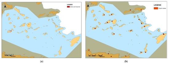
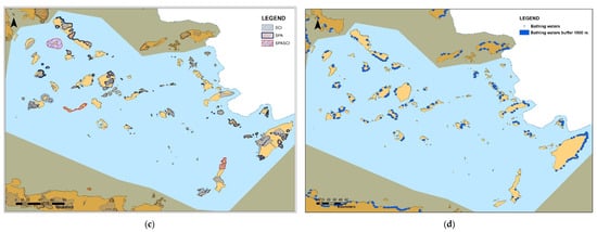
Figure 3.
Thematic maps of exclusion criteria related to: (a) mines and quarries (EC3), (b) airports (EC4), (c) Natura 2000 (EC6), and (d) bathing waters.
By overlapping the thematic maps of all the exclusion criteria, UIs that are inappropriate for the siting of windfarms in terms of technical, economic, and environmental constraints were determined. Figure 4 depicts the inappropriate areas, whereas Table 3 lists the eligible areas, including their name and area. In total, 27 UIs with a total area of 5.434 km2 were identified.
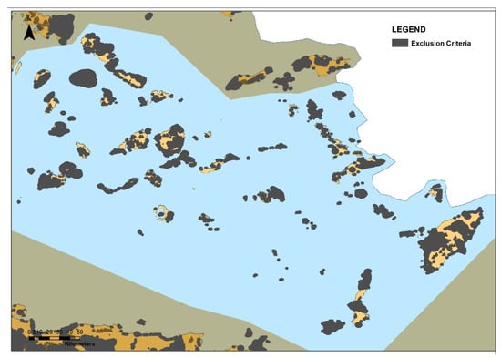
Figure 4.
Inappropriate areas for the siting of wind farms on UIs in the region of the South Aegean, Greece.
Table 3.
Characteristics of eligible UIs for the siting of wind farms in the region of the South Aegean, Greece.
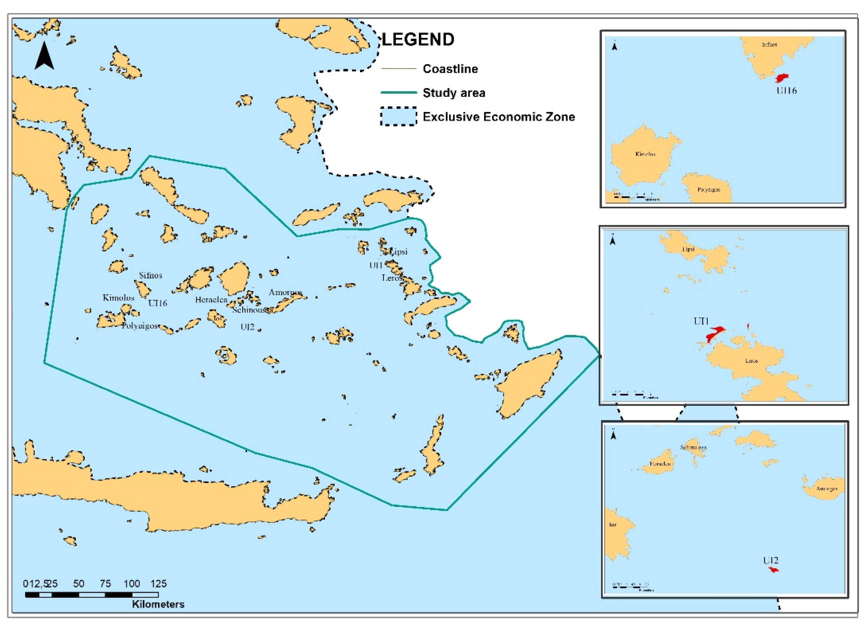
The criterion of the area required for a wind farm was applied in the final step of the first stage after imposing all the other restrictions in the GIS environment. The corresponding results indicated three eligible UIs in the region of the Aegean Sea, which are shown in Figure 5.

Figure 5.
Eligible UIs for wind farm siting in the region of the South Aegean, Greece, after implementation of all the exclusion criteria.
Archangelos (UI1) is an uninhabited Greek island located northwest of the island of Leros in the Dodecanese Archipelago. Administratively, it is part of the municipality of Leros, the Kalymnos Regional Unit, and the South Aegean islands. Anydros (UI2), also known as Amorgopoula, is a small uninhabited islet in the southeastern Cyclades. It is bordered by the islands of Santorini, Amorgos, Ios, Anafi, and Astypalea in the center of the marine area. The distance of the islet from Amorgos and Santorini is 18.5 km2 and 37 km2, respectively. Administratively, it is part of the municipality of Amorgos, which is the easternmost island of the Cyclades Island group. Kitriani (UI16) is a rocky uninhabited island in the Cyclades. It is located south of Sifnos and very close to its shores. Administratively, it belongs to the municipality of Sifnos.
3.2. Weighting of the Assessment Criteria under Different Scenarios
After defining the assessment criteria, the AHP was used to quantify their relative weights, which indicate the importance and the influence of each criterion to the overall goal. In this study, we used four different scenarios: (i) the baseline scenario according to the authors’ expertise (Scenario 1: BS), (ii) equal criterion weights (Scenario 2: EWS), (iii) the technical–economic-oriented policy scenario (Scenario 3: TEOPS), and (iv) the environmentally oriented policy scenario (Scenario 4: EOPS). Table 4 depicts the 6 × 6 pairwise comparison matrix of the six assessment criteria used in this study to determine the preferred order for wind farm siting in UIs in the region of the South Aegean, Greece, based on authors’ experience and judgement (Scenario 1). The normalized 6 × 6 matrix was calculated by dividing each element of the matrix by the corresponding sum of the vertical column to which it belongs (Table 5). The weights of the criteria were calculated by averaging the normalized values of the corresponding horizontal row. It should be noted that the CR of the 6 × 6 matrix is less than the 0.1, confirming the consistency of the judgements.
Table 4.
Pairwise comparison matrix of the assessment criteria with respect to the goal under Scenario 1.
Table 5.
Normalized pairwise comparison matrix of the assessment criteria with respect to the goal under Scenario 1.
The relevant weights of each AC under the four different scenarios are presented in Figure 6. The relative weights of AC1 obtained the highest values in Scenario 1 and Scenario 3, indicating that the WV was the most important assessment criterion. This result is in line with the findings of other studies in the literature (e.g., [2,38,55,56]). Although the SoT has been neglected in several studies so far (e.g., [40,57]), in our study, the relative weights of AC2 received high values in Scenario 1 and Scenario 3, as it can significantly affect the cost of construction. In Scenario 4, which focuses on environmental criteria, priority is given to AC3, AC4, and AC5. The SA and PS are related to the amount of energy produced and consumed from renewable energy sources, leading to lower CO2 emissions, while PEA ensures the minimum impact of wind farm projects on the environment.
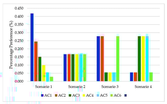
Figure 6.
Relevant weights of AC with respect to the goal under different scenarios.
3.3. Feasible Sites Prioritization
According to Formulas (7)–(9) for the three UI alternatives, the Euclidean distances of the alternatives from the positive and the negative ideal solutions ( and ), as well as the closeness coefficient of each alternative to the optimal ideal and the non-optimal ideal solution , are presented in Table 6.
Table 6.
, , and values under the different scenarios.
The optimal alternative is the one that has a as close as possible to 1; hence, this corresponds to alternative site UI2 (Anydros, Amorgos) in all four scenarios. The results recommend the following ranking in all cases: UI1 (Archangelos, Leros) and UI16 (Kitriani, Sifnos). The existence of the highest surface area (AC3), as well as the benefit of the location of the first choice (UI1) being able to serve a large population (AC4), contributed the most to this ranking.
4. Conclusions
This study presents a MCDM–GIS based approach to identify suitable UIs for utility-scale wind farms in the region of the South Aegean, Greece. Identifying the most preferable sites for wind farm deployment is a preliminary and necessary step for the utilization of this renewable energy source for energy generation purposes. Although there are numerous studies in the literature investigating either onshore or offshore wind farm siting issues, this is the first ever site suitability study for wind farm deployment on uninhabited islets.
Through this work, a methodological framework for sustainable wind farm siting on UIs is suggested. A combined GIS and MCDM approach contributed to the solution of complex siting problems and facilitated the decision-making process. In this study, we considered several different criteria regarding environmental protection, economic feasibility, and technical constraints and integrated them in a sustainable way.
The main conclusions of the current research can be summarized as follows:
- Twenty (20) criteria (exclusion and assessment) were selected, based on the restrictions imposed by the national legal framework as well as onshore and offshore wind farm siting literature.
- The criterion of installation site area limitations (EC14) was crucial in the present study since it contributed to the exclusion of almost 89% of the eligible UIs.
- According to baseline scenario based on the authors’ expertise (Scenario 1) and the technical–economic-oriented policy scenario (Scenario 3), two technical/economic criteria (WV and SoT) represented the most important AC, while in the environmentally oriented policy scenario (Scenario 4), priority was given to environmental–economic criteria (SA, PS, and PEA).
- One primary limitation of using MCDM approaches in planning sites for energy generation is that they may lead decision makers to a subjective solution. However, our study surpassed the above restriction, since various and different policy scenarios were considered.
- The suitable UIs received the same ranking under the four different policy scenarios deployed (baseline, equal criterion weights, the policy scenario focusing on technical–economic considerations, and the environmentally oriented policy scenario), thus, contributing to the reliability of results.
- UI2 (Anydros near Amorgos) is the most preferable UI. This is mainly attributed to the simultaneous existence of the highest surface area, as well the ability of this location to serve a large population.
- The findings of the present study show the potential for installing wind farm projects in uninhabited islets and can be used to pinpoint particular locations in the South Aegean region. However, the implementation of such projects necessitates the development of a proper legislative framework related to the spatial planning of renewable energy projects.
The advantages of the proposed method are summarized as follows: (i) it uses 20 exclusion and assessment criteria, integrating environmental, social, technical, and economic aspects; (ii) it combines two multicriteria analyses (AHP and TOPSIS) and takes advantage of the benefits of each one of them; and (iii) four different scenarios were developed to check the reliability of results. In this way, the main limitation of the use of MCDM methods was eliminated, thus, guiding decision makers to a solution that works best within their jurisdiction.
One drawback of the proposed methodology is the availability of data. The researcher should obtain various types of spatial data to create the corresponding thematic maps in the exclusion stage. Although several types of data can be found either in a vector or a raster format, there are others available only in a raw format, which should be digitized accordingly using GIS, which is a time-consuming task.
The inclusion of additional specific economic criteria such as investment costs will enhance the results of the present study from an economic point of view. In addition, the involvement and participation of the relevant stakeholders as well as the interested public, at least in providing their preferences for the assessment criteria, are suggested to ensure the social acceptability of renewable energy projects.
Despite the vast body of literature considering the deployment of onshore wind farms on continental land and offshore wind farms, to the authors’ knowledge, there is no study investigating the potential of developing wind farms on uninhabited islets. The advantages of this space category compared with similar wind farm projects in insular areas, either onshore or offshore, focus on the two very important issues as follows. First, the unavailability of land due to land use heterogeneity in the islands, in addition to having little or no visual impact at all, could respond to social reactions and phenomena such as the Not in My Backyard (NIMBY), Build Absolutely Nothing Anywhere Near Anything (BANANA), and Citizens Against Virtually Everything (CAVE) phenomena, which often prevail in insular environments. Second, in the UIs, larger wind turbines could be installed compared with those that exist in the Greek islands and, as a consequence, larger quantities of energy could be produced, and more local energy needs could be covered.
This methodology is flexible and adaptable to any insular environment because of its specific and unique characteristics. In addition, energy planners and policymakers can use the proposed methodology for any other renewable energy siting process, since it can incorporate a variety of both exclusion and assessment criteria.
Author Contributions
Conceptualization, D.G.V. and V.A.; methodology, D.G.V. and V.A.; software, D.G.V. and V.A.; formal analysis, D.G.V. and V.A.; investigation, V.A.; data curation, D.G.V. and V.A.; writing—original draft preparation, D.G.V. and V.A.; writing—review and editing, D.G.V.; visualization, D.G.V. and V.A.; supervision, D.G.V. All authors have read and agreed to the published version of the manuscript.
Funding
This research received no external funding.
Institutional Review Board Statement
Not applicable.
Informed Consent Statement
Not applicable.
Data Availability Statement
Not applicable.
Conflicts of Interest
The authors declare no conflict of interest.
References
- Latinopoulos, D.; Kechagia, K. A GIS-based multi-criteria evaluation for wind farm site selection. A regional scale application in Greece. Renew. Energy 2015, 78, 550–560. [Google Scholar] [CrossRef]
- Baseer, M.A.; Rehman, S.; Meyer, J.P.; Mahbub Alam, M. GIS-based site suitability analysis for wind farm development in Saudi Arabia. Energy 2017, 141, 1166–1176. [Google Scholar] [CrossRef] [Green Version]
- Bili, A.; Vagiona, D.G. Use of multicriteria analysis and GIS for selecting sites for onshore wind farms: The case of Andros Island (Greece). Eur. J. Environ. Sci. 2018, 8, 5–13. [Google Scholar] [CrossRef]
- Ayodele, T.R.; Ogunjuyigbe, A.S.O.; Odigie, O.; Munda, J.L. A multi-criteria GIS based model for wind farm site selection using interval type-2 fuzzy analytic hierarchy process: The case study of Nigeria. Appl. Energy 2018, 228, 1853–1869. [Google Scholar] [CrossRef]
- Höfer, T.; Sunak, Y.; Siddique, H.; Madlener, R. Wind farm siting using a spatial Analytic Hierarchy Process approach: A case study of the Städteregion Aachen. Appl. Energy 2016, 163, 222–243. [Google Scholar] [CrossRef]
- Ali, S.; Taweekun, J.; Techato, K.; Waewsak, J.; Gyawali, S. GIS based site suitability assessment for wind and solar farms in Songkhla, Thailand. Renew. Energy 2019, 132, 1360–1372. [Google Scholar] [CrossRef]
- Watson, J.J.W.; Hudson, M.D. Regional Scale wind farm and solar farm suitability assessment using GIS-assisted multi-criteria evaluation. Landsc. Urban Plan. 2015, 138, 20–31. [Google Scholar] [CrossRef]
- Sarpong, D.; Baffoe, P.E. Selecting Suitable Sites for Wind Energy Development in Ghana. Ghana Min. J. 2016, 16, 8–20. [Google Scholar]
- Villacreses, G.; Gaona, G.; Martínez-Gomez, J.; Juan Jijon, D. Wind farms suitability location using geographical information system (GIS), based on multi-criteria decision making (MCDM) methods: The case of continental Ecuador. Renew. Energy 2017, 109, 275–286. [Google Scholar] [CrossRef]
- Mahdy, M.; Bahaj, A.S. Multi criteria decision analysis for offshore wind energy potential in Egypt. Renew. Energy 2018, 118, 278–289. [Google Scholar] [CrossRef]
- Spyridonidou, S.; Vagiona, D.G.; Loukogeorgaki, E. Strategic Planning of Offshore Wind Farms in Greece. Sustainability 2020, 12, 905. [Google Scholar] [CrossRef] [Green Version]
- Vagiona, D.G.; Kamilakis, M. Sustainable site selection for offshore wind farms in the South Aegean-Greece. Sustainability 2018, 10, 749. [Google Scholar] [CrossRef] [Green Version]
- Christoforaki, M.; Tsoutsos, T. Sustainable siting of an offshore wind park a case in Chania, Crete. Renew. Energy 2017, 109, 624–633. [Google Scholar]
- Gavériaux, L.; Laverrière, G.; Wang, T.; Maslov, N.; Claramunt, C. GIS-based multi-criteria analysis for offshore wind turbine deployment in Hong Kong. Ann. GIS 2019, 25, 207–218. [Google Scholar] [CrossRef]
- Emeksiz, C.; Demirci, B. The determination of offshore wind energy potential of Turkey by using novelty hybrid site selection method. Sustain. Energy Technol. Assess. 2019, 36, 100562. [Google Scholar] [CrossRef]
- Vagiona, D.G.; Karanikolas, N.M. A multicriteria approach to evaluate offshore wind farms siting in Greece. Glob. NEST J. 2012, 14, 235–243. [Google Scholar]
- Spyridonidou, S.; Vagiona, D.G. Spatial energy planning of offshore wind farms in Greece using GIS and a hybrid MCDM methodological approach. Euro-Mediterr. J. Environ. Integr. 2020, 5, 24. [Google Scholar] [CrossRef]
- Schallenberg-Rodríguez, J.; Montesdeoca, N.G. Spatial planning to estimate the offshore wind energy potential in coastal regions and islands. Practical case: The Canary Islands. Energy 2018, 143, 91–103. [Google Scholar] [CrossRef]
- Tegou, L.-I.; Polatidis, H.; Haralambopoulos, D.A. Environmental management framework for wind farm siting: Methodology and case study. J. Environ. Manag. 2010, 91, 2134–2147. [Google Scholar] [CrossRef]
- Panagiotidou, M.; Xydis, G.; Koroneos, C. Environmental Siting Framework for Wind Farms: A Case Study in the Dodecanese Islands. Resources 2016, 5, 24. [Google Scholar] [CrossRef] [Green Version]
- Bertsiou, M.M.; Theochari, A.P.; Baltas, E. Multi-criteria analysis and Geographic Information Systems methods for wind turbine siting in a North Aegean island. Energy Sci. Eng. 2021, 9, 4–18. [Google Scholar] [CrossRef]
- Feloni, E.; Karandinaki, E. GIS-based MCDM Approach for Wind Farm Site Selection—A Case Study. J. Energy Power Technol. 2021, 3, 39. [Google Scholar] [CrossRef]
- Soares-Ramos, Ε.P.P.; de Oliveira-Assis, L.; Sarrias-Mena, R.; Fernández-Ramírez, L.M. Current status and future trends of offshore wind power in Europe. Energy 2020, 202, 117787. [Google Scholar] [CrossRef]
- IPCC. Climate Change 2007: Synthesis Report. Contribution of Working Groups I, II and III to the Fourth Assessment Report of the Intergovernmental Panel on Climate Change; Core Writing Team; Pachauri, R.K., Reisinger, A., Eds.; IPCC: Geneva, Switzerland, 2007; 104p. [Google Scholar]
- Hellenic Statistical Authority. Available online: http://www.statistics.gr/ (accessed on 29 January 2022).
- Ministry of Environment and Energy. Specific Framework for Spatial Planning and Sustainable Development for Renewable Energy Sources. Available online: https://ypen.gov.gr/wp-content/uploads/2020/11/FEK2464B_2008_RES.pdf (accessed on 17 January 2022).
- National Open Data Catalogue. Available online: www.geodata.gov.gr (accessed on 15 April 2022).
- Hellenic Navy Hydrographic Service. Available online: www.hnhs.gr (accessed on 15 April 2022).
- Mining and Quarrying Sites. Available online: www.latomet.gr (accessed on 15 April 2022).
- Greek Biotope/Wetland Centre. Available online: https://www.ekby.gr/ (accessed on 15 April 2022).
- Baban, S.M.J.; Parry, T. Developing and applying a GIS-assisted approach to locating wind farms in the UK. Renew. Energy 2001, 24, 59–71. [Google Scholar] [CrossRef]
- Ministry of Environment and Energy. Available online: www.ypen.gov.gr (accessed on 15 April 2022).
- Maps Portal of Geospatial Information. Available online: www.mapsportal.ypen.gr (accessed on 15 April 2022).
- Permanent List of Archaeological Sites and Monuments of Greece. Available online: www.listedmonuments.culture.gr (accessed on 15 April 2022).
- Tegou, L.I.; Polatidis, H.; Haralambopoulos, D.A. Distributed Generation with Renewable Energy Systems: The spatial dimension for an autonomous Grid. In Proceedings of the 47th Conference of the European Regional Science Association, Local Governance and Sustainable Development, Paris, France, 29 August–2 September 2007. [Google Scholar]
- Effat, H. Spatial Modeling of Optimum Zones for Wind Farms Using Remote Sensing and Geographic Information System, Application in the Red Sea, Egypt. J. Geogr. Inf. Syst. 2014, 6, 358–374. [Google Scholar] [CrossRef] [Green Version]
- Regularatory Authority for Energy. Available online: www.rae.gr (accessed on 15 April 2022).
- Van Haaren, R.; Fthenakis, V. GIS-based wind farm site selection using spatial multi-criteria analysis (SMCA): Evaluating the case for New York State. Renew. Sustain. Energy Rev. 2011, 15, 3332–3340. [Google Scholar] [CrossRef]
- Al-Yahyai, S.; Charabi, Y.; Gastli, A.; Al-Badi, A. Wind farm land suitability indexing using multi-criteria analysis. Renew. Energy 2012, 44, 80–87. [Google Scholar] [CrossRef]
- Gorsevski, P.V.; Cathcart, S.C.; Mirzaei, G.; Jamali, M.M.; Ye, X.; Gomezdelcampo, E. A group-based spatial decision support system for wind farm site selection in Northwest Ohio. Energy Policy 2013, 55, 374–385. [Google Scholar] [CrossRef]
- Anwarzai, M.A.; Nagasaka, K. Utility-scale implementable potential of wind and solar energies for Afghanistan using GIS multi-criteria decision analysis. Renew. Sustain. Energy Rev. 2017, 71, 150–160. [Google Scholar] [CrossRef]
- Saraswat, S.K.; Digalwar, A.K.; Yadav, S.S.; Kumar, G. MCDM and GIS based modelling technique for assessment of solar and wind farm locations in India. Renew. Energy 2021, 169, 865–884. [Google Scholar] [CrossRef]
- Kim, C.-K.; Jang, S.; Kim, T.Y. Site selection for offshore wind farms in the southwest coast of South Korea. Renew. Energy 2018, 120, 151–162. [Google Scholar] [CrossRef]
- Mekonnen, A.D.; Gorsevski, P.V. A web-based participatory GIS (PGIS) for offshore wind farm suitability within Lake Erie, Ohio. Renew. Sustain. Energy Rev. 2015, 41, 162–177. [Google Scholar] [CrossRef] [Green Version]
- Argin, M.; Yerci, V. The assessment of offshore wind power potential of Turkey. In Proceedings of the 9th International Conference on Electrical and Electronics Engineering (ELECO), Bursa, Turkey, 26–28 November 2015. [Google Scholar]
- Möller, B. Continuous spatial modelling to analyse planning and economic consequences of offshore wind energy. Energy Policy 2011, 39, 511–517. [Google Scholar] [CrossRef]
- Saleous, N.; Issa, S.; Al Mazrouei, J. GIS-based wind farm site selection model offshore Abu Dhabi Emirate, UAE. Int. Arch. Photogramm. Remote Sens. Spat. Inf. Sci. 2016, 41, 437–441. [Google Scholar] [CrossRef] [Green Version]
- Saaty, R.W. The analytic hierarchy process—What it is and how it is used. Math. Modell. 1987, 9, 161–176. [Google Scholar] [CrossRef] [Green Version]
- Saaty, T.L. How to make a decision: The analytic hierarchy process. Eur. J. Oper. Res. 1990, 48, 9–26. [Google Scholar] [CrossRef]
- Vasileiou, M.; Loukogeorgaki, E.; Vagiona, D.G. GIS-based multi-criteria decision analysis for site selection of hybrid offshore wind and wave energy systems in Greece. Renew. Sustain. Energy Rev. 2017, 73, 745–757. [Google Scholar] [CrossRef]
- Spyridonidou, S.; Vagiona, D.G. A comparative analysis of decision-making methods on site suitability for on-and offshore wind farms: The case of regional unit of Euboea, Greece. Circ. Econ. Sustain. 2021, 1–14. [Google Scholar] [CrossRef]
- Hwang, C.L.; Yoon, K. Methods for multiple attribute decision making. In Multiple Attribute Decision Making: Lecture Notes in Economics and Mathematical Systems, 1st ed.; Springer: Berlin/Heidelberg, Germany, 1981; Volume 186, pp. 58–191. [Google Scholar]
- Opricovic, S.; Tzeng, G.H. Compromise solution by MCDM methods: A comparative analysis of VIKOR and TOPSIS. Eur. J. Oper. Res. 2004, 156, 445–455. [Google Scholar] [CrossRef]
- ArcGIS. GIS Software, version 10.4.1; Environmental Systems Research Institute, Inc.: Redlands, CA, USA, 2018.
- Sliz-Szkliniarz, B.; Vogt, J. GIS-based approach for the evaluation of wind energy potential: A case study for the Kujawsko–Pomorskie Voivodeship. Renew. Sustain. Energy Rev. 2011, 15, 1696–1707. [Google Scholar] [CrossRef]
- Siyal, S.; Mörtberg, U.; Mentis, D.; Welsch, M.; Babelon, I.; Howells, M. Wind energy assessment considering geographic and environmental restrictions in Sweden: A GIS-based approach. Energy 2015, 83, 447–461. [Google Scholar] [CrossRef]
- Aydin, N.; Kentel, E.; Duzgun, S. GIS-based environmental assessment of wind energy systems for spatial planning: A case study from Western Turkey. Renew. Sustain. Energy Rev. 2010, 14, 364–373. [Google Scholar] [CrossRef]


Publisher’s Note: MDPI stays neutral with regard to jurisdictional claims in published maps and institutional affiliations. |
© 2022 by the authors. Licensee MDPI, Basel, Switzerland. This article is an open access article distributed under the terms and conditions of the Creative Commons Attribution (CC BY) license (https://creativecommons.org/licenses/by/4.0/).