

Between Water and Land: An Urban and Architectural Response to Climate Change in Red Hook, Brooklyn


Abstract
1. Introduction
1.1. Climate Change and Coastal Resilience
1.2. Risks Posed by Changing Coastlines
2. Materials and Methods
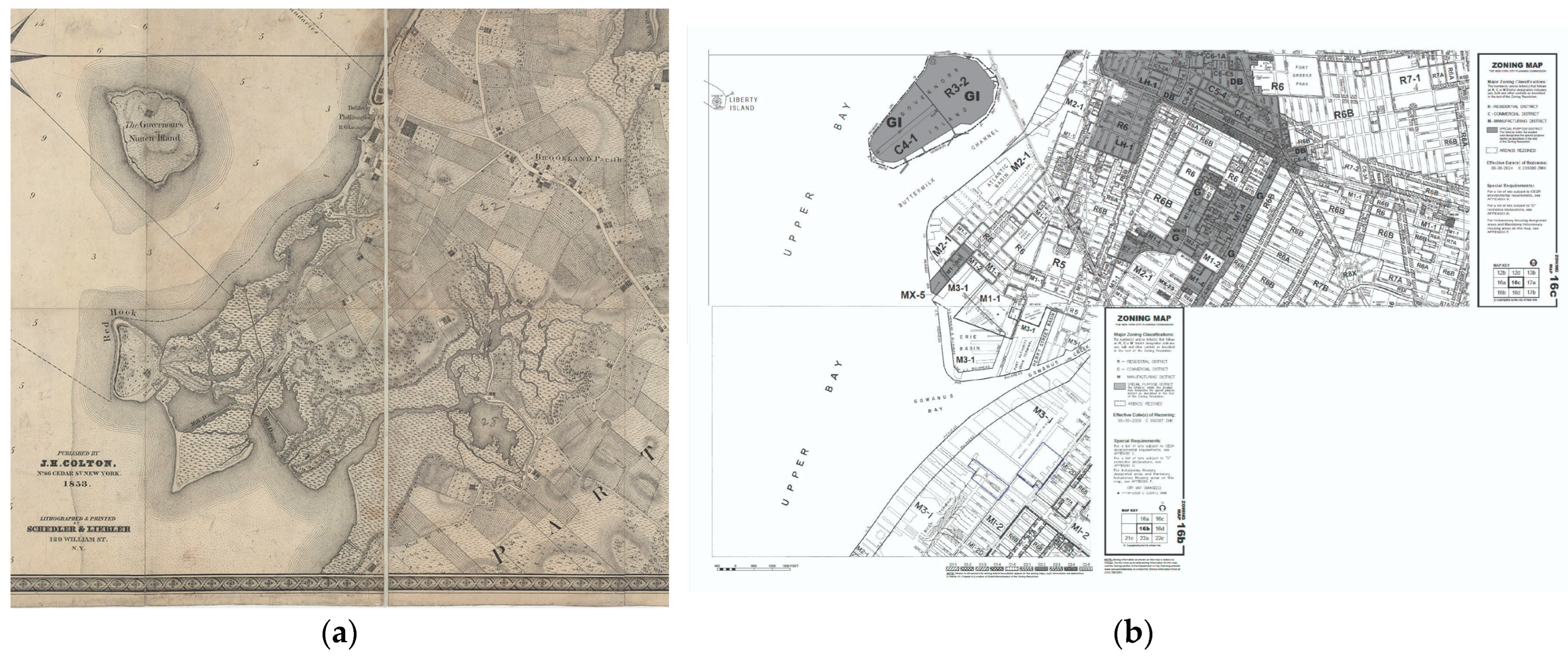
2.1. Why Red Hook?
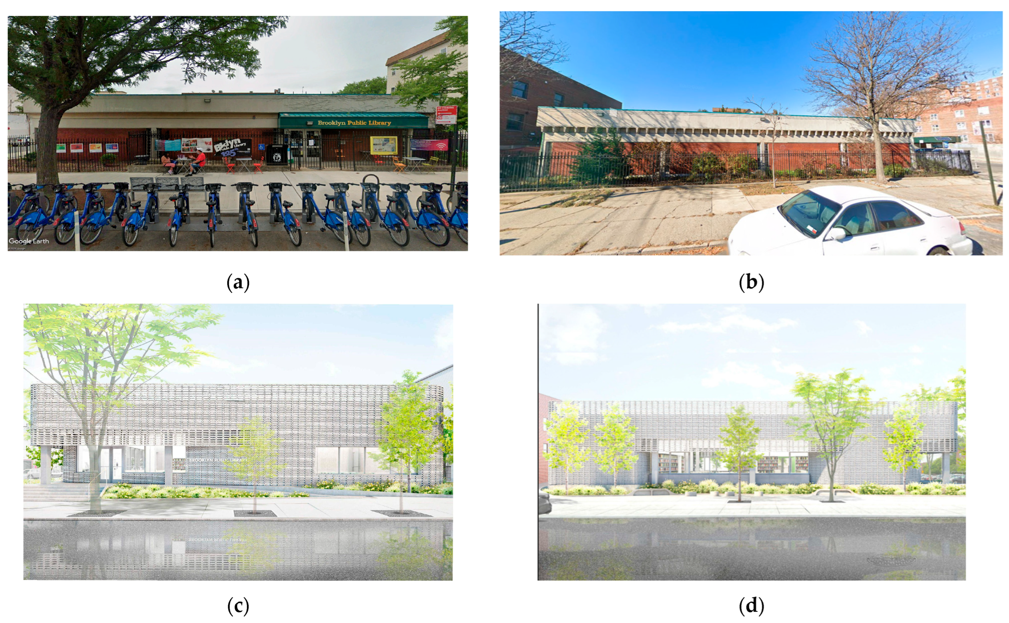
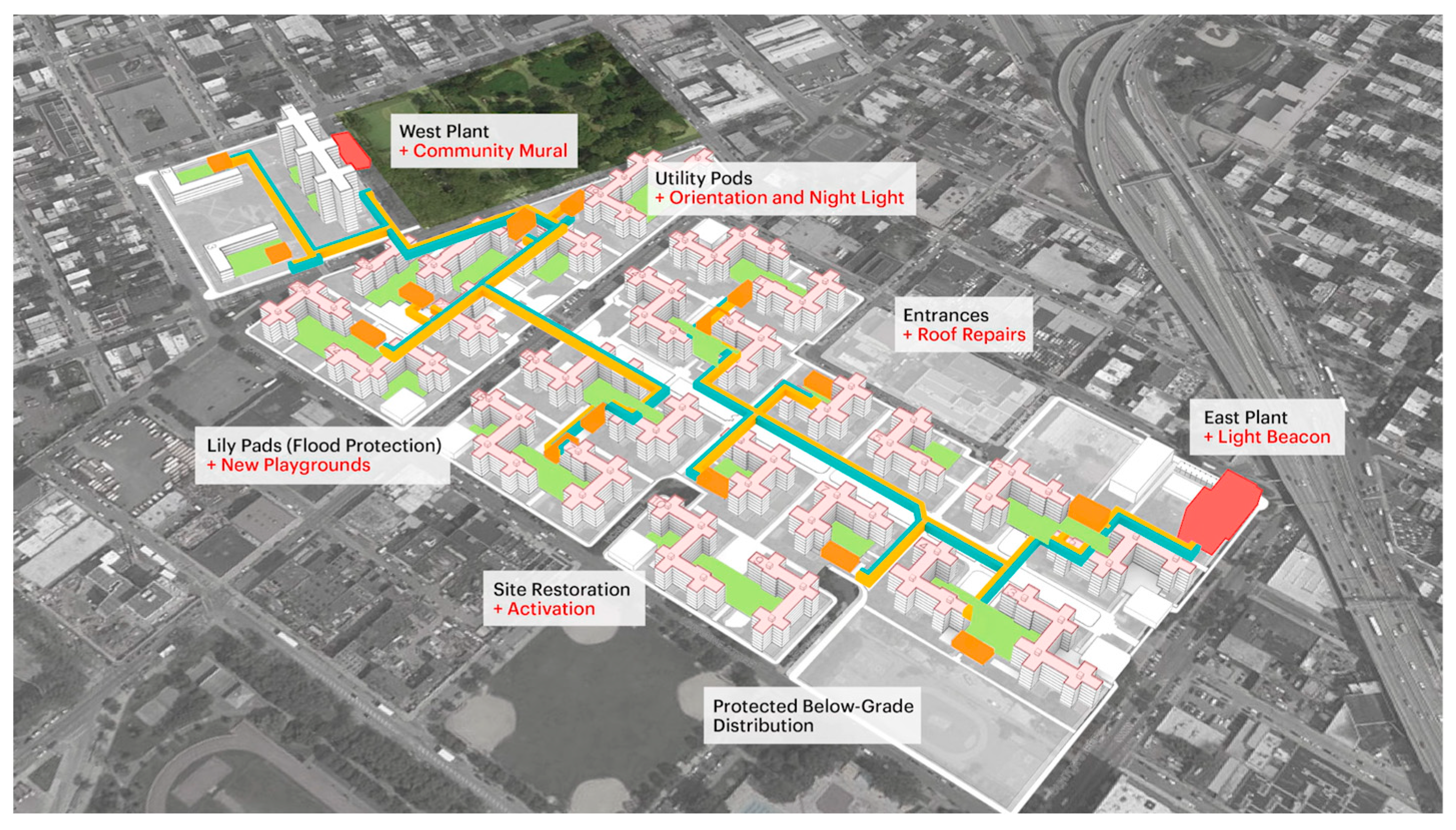
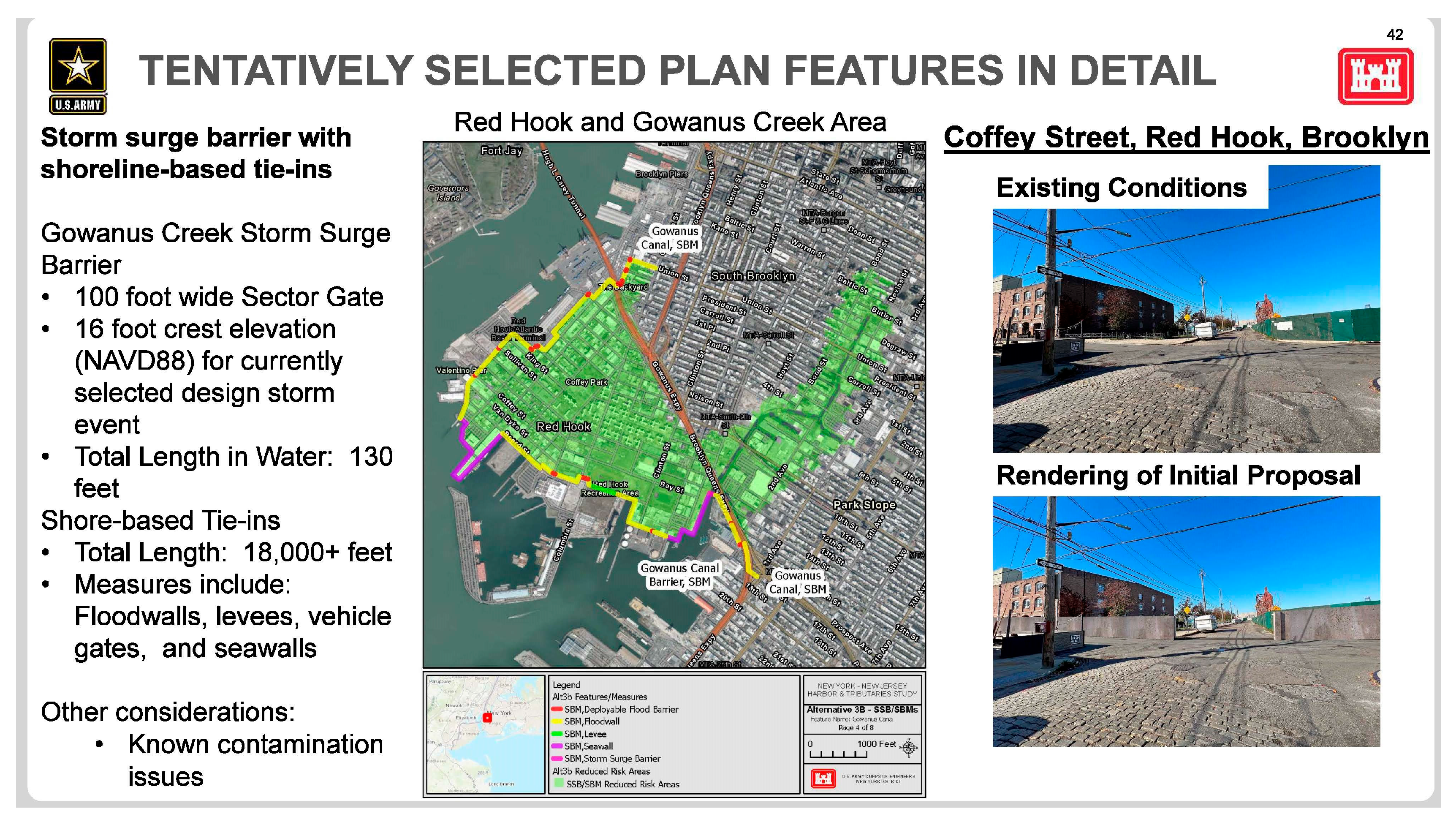
2.2. Resilience in Red Hook Today
3. Results
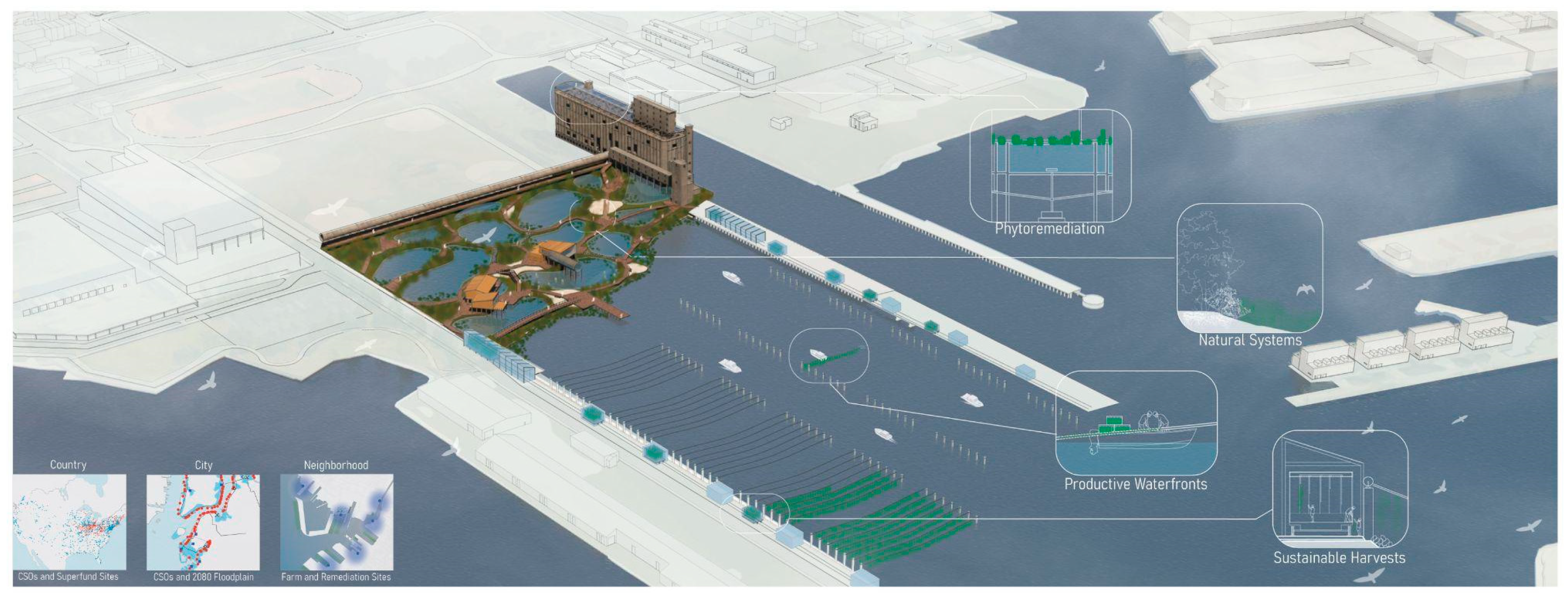
3.1. The City
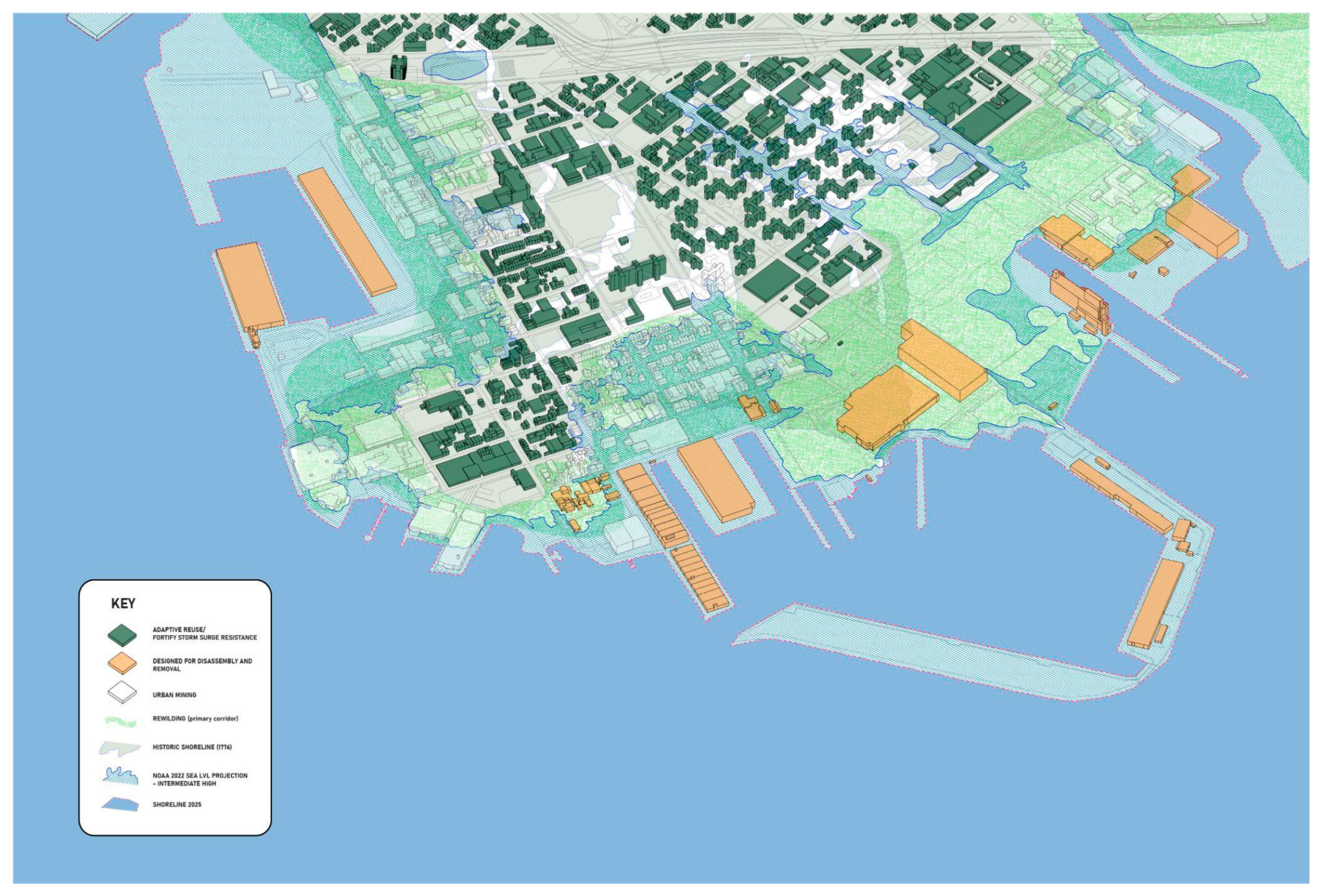
3.2. The Neighborhood
4. Discussion
4.1. Where Do We Go from Here?—Resilient Regrowth Across a Changing Coastline
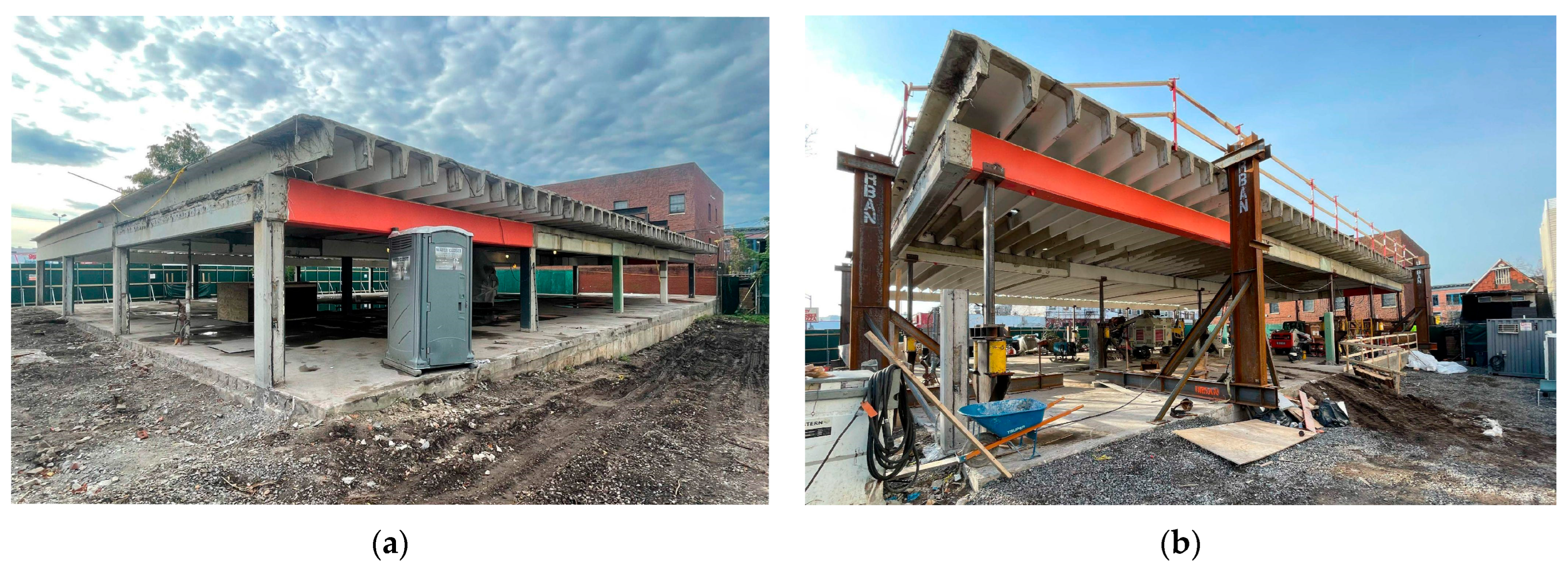
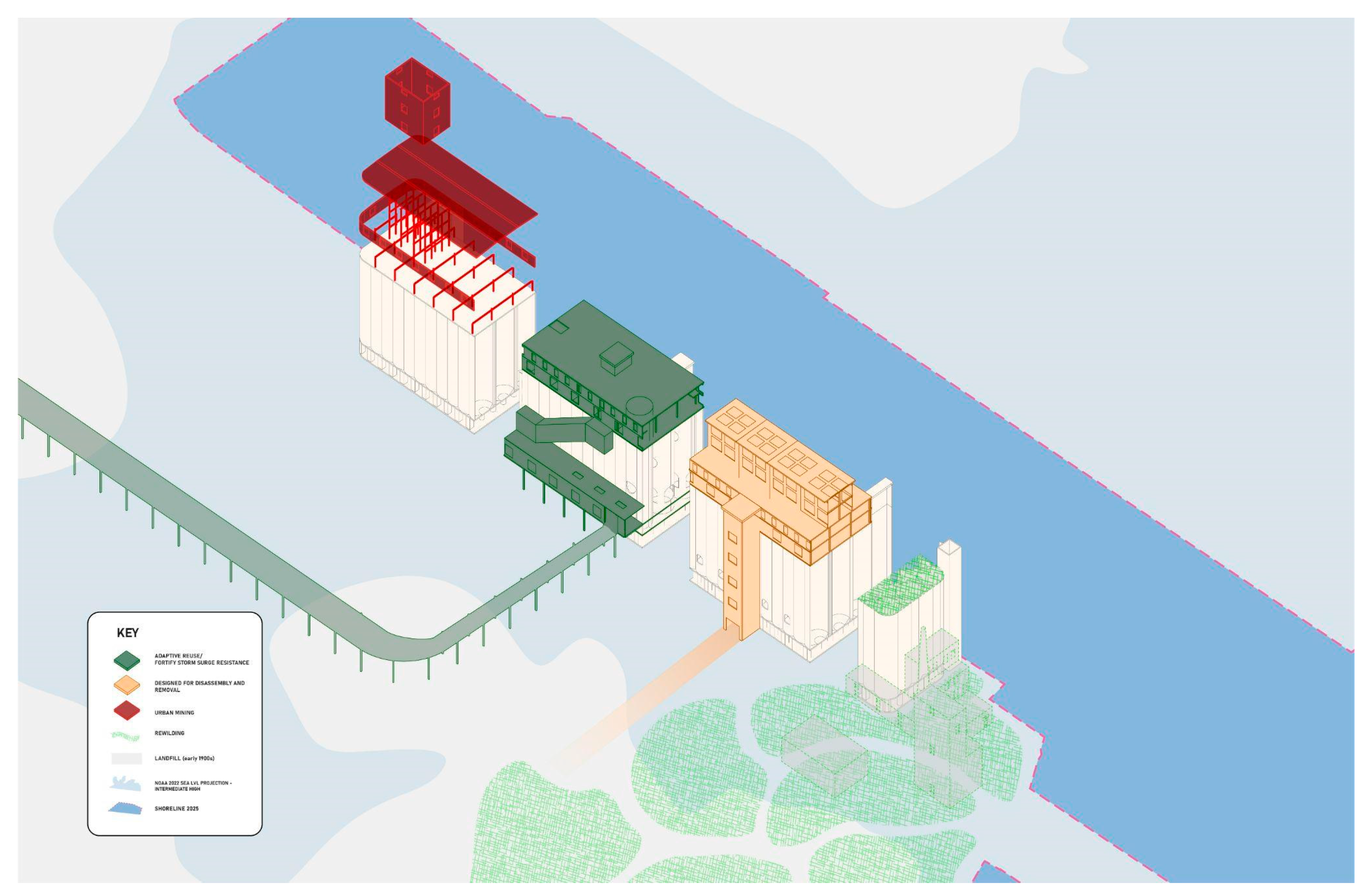
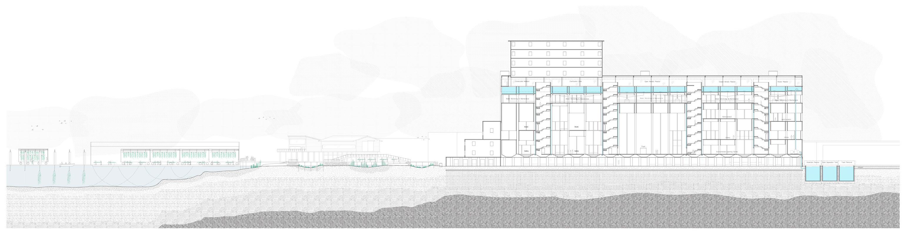
4.2. Regrowth Through Adaptive Reuse—Banking Embodied Carbon and Energy
4.3. Regrowth Through Urban Mining
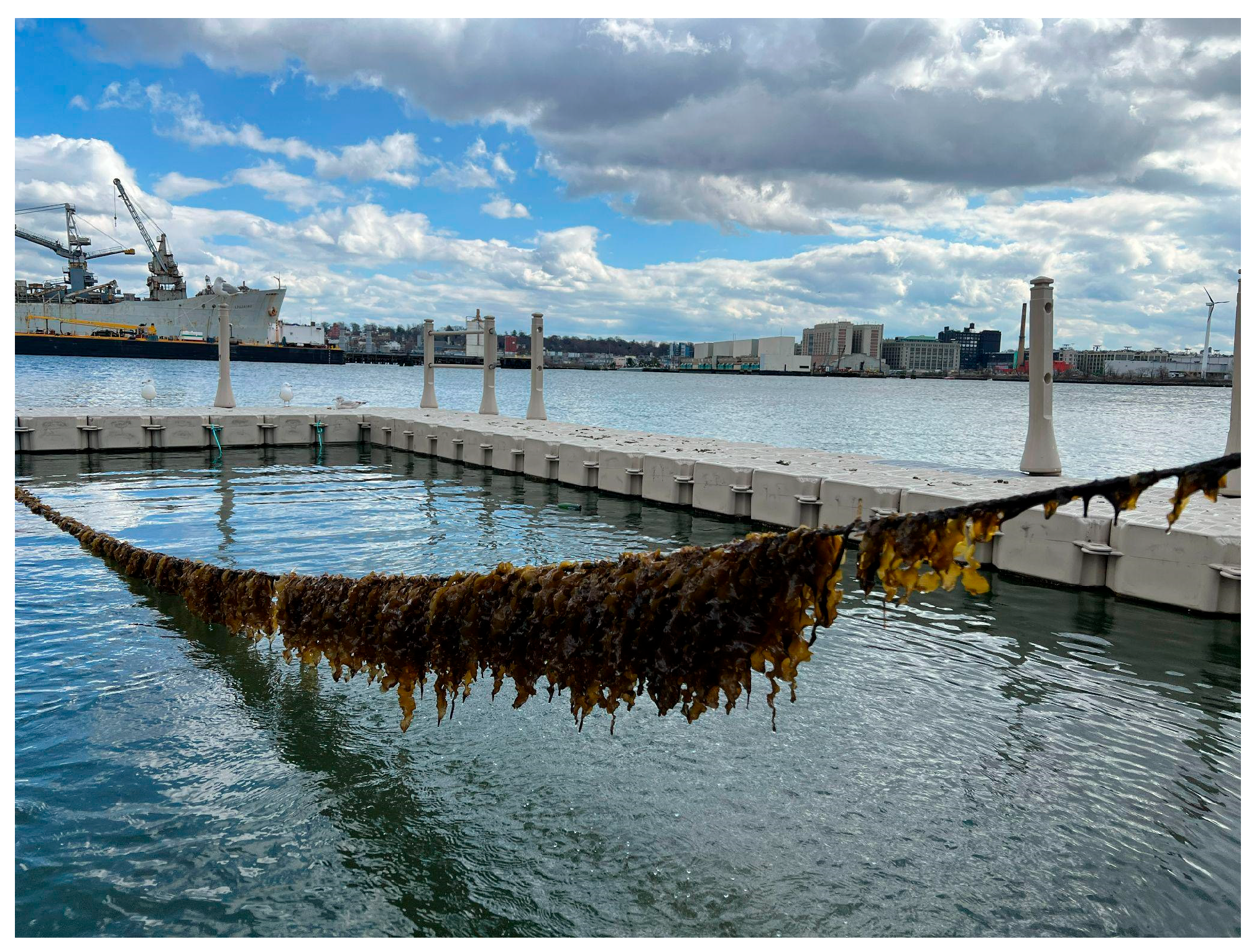
4.4. Nature-Based Regrowth
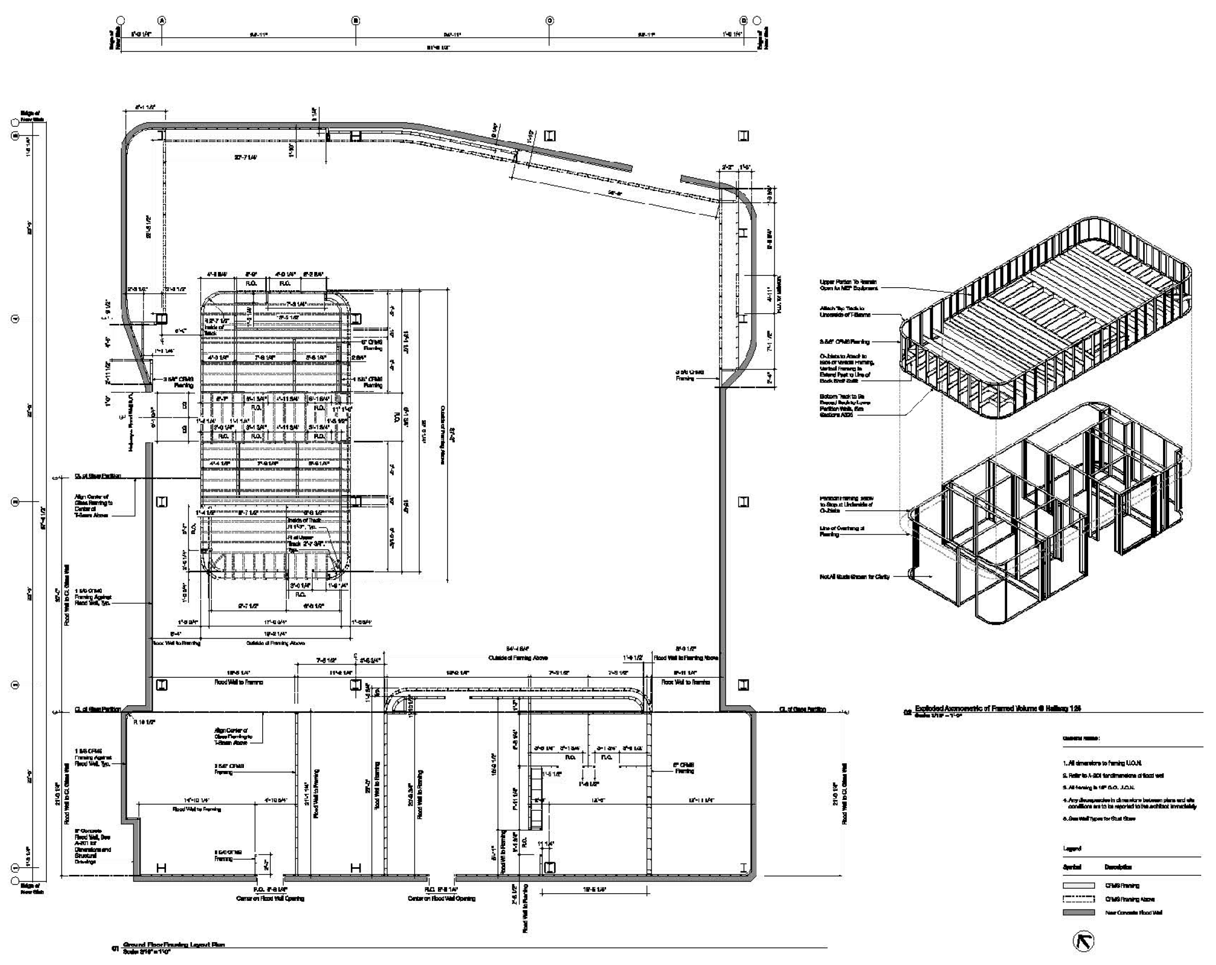
4.5. New Construction—Designing for Disassembly (DfD)
5. Conclusions
- The Human: Social and community resilience networks responding to climate change must be built up at the same pace as physical resilience efforts to ease the transition into a more dynamic coastal landscape.
- a.
- As the coastal landscape becomes less “solid”, the ecology of urban social networks of trust and cooperation emerge as even more important factors to climate resilience in both the short and long term. These must be supported to bolster their ability to react and adapt to projected changes.
- The Building: Climate change has altered the way architectural design will be evaluated. Buildings can no longer be considered static objects, but are instead temporary repositories/collections of energy and materials that are designed to change over time.
- a.
- Resilience efforts at the architectural scale cannot be motivated solely by a building withstanding the storm surge threat, but must equally account for future changes in form and program motivated by projected sea level rise and resulting changes in the urban fabric.
- The City: Comprehensive urban resilience requires the ambition and capacity to reimagine urban development and design across the coastal hazard zone. Cities must conceive of their coastal neighborhoods as fundamentally different landscapes than they are now—adaptable to their future shifting conditions and coastlines.
- a.
- Coastal resilience must adapt alongside projected changes in sea level rise, framing resilience as a transition from a static to a dynamic relationship with the coastal landscape.
Author Contributions
Funding
Institutional Review Board Statement
Informed Consent Statement
Data Availability Statement
Acknowledgments
Conflicts of Interest
Abbreviations
| CSO | Combined Sewer Overflow |
| NYCHA | New York City Housing Authority |
| ZCFR | Zoning for Coastal Flood Resiliency |
| HATS | Harbor Area Tributaries Study |
| CRDG | Coastal Resiliency Design Guidelines |
| DfD | Design for Disassembly |
| RETI | Resilience Education Training Innovation Center |
| 1 | Superfund 2 sites are determined to be a significant threat to the public heath or environment by NYC. |
| 2 | Referring to construction elements made of a single material type for ease of disassembly, recycling, and re-use |
References
- Intergovernmental Panel On Climate Change (IPCC). Climate Change 2022—Impacts, Adaptation and Vulnerability: Working Group II Contribution to the Sixth Assessment Report of the Intergovernmental Panel on Climate Change, 1st ed.; Cambridge University Press: Cambridge, UK, 2023. [Google Scholar] [CrossRef]
- Department of City Planning. Zoning for Coastal Flood Resiliency Project Description; Department of City Planning: New York, NY, USA, 2021. [Google Scholar]
- NYC Flood Hazard Mapper. NYC Department of City Planning, 6 November 2017. Available online: https://www.arcgis.com/apps/webappviewer/index.html?id=1c37d271fba14163bbb520517153d6d5 (accessed on 28 May 2025).
- Wannewitz, M.; Ajibade, I.; Mach, K.J.; Magnan, A.; Petzold, J.; Reckien, D.; Ulibarri, N.; Agopian, A.; Chalastani, V.I.; Hawxwell, T.; et al. Progress and gaps in climate change adaptation in coastal cities across the globe. Nat. Cities 2024, 1, 610–619. [Google Scholar] [CrossRef]
- Sharlach, M. Resilient Shores: After Sandy, Climate Scientists and Architects Explore How to Co-Exist with Rising Tides. Discov. Res. Princet. Mag. November 2014. Available online: https://discovery.princeton.edu/2014/11/14/resilient-shores-after-sandy-climate-scientists-and-architects-explore-how-to-co-exist-with-rising-tides/ (accessed on 12 March 2025).
- Hillen, M.M.; Dolman, N. Towards Water Adaptive Cities. In Proceedings of the World Engineers Summit on Climate Change (WES) 2015, Singapore, 21–24 July 2015. [Google Scholar]
- Foster, S.R.; Baptista, A.; Nguyen, K.H.; Tchen, J.; Tedesco, M.; Leichenko, R. NPCC4: Advancing climate justice in climate adaptation strategies for New York City. Ann. N. Y. Acad. Sci. 2024, 1539, 77–126. [Google Scholar] [CrossRef] [PubMed]
- Jurjonas, M.; Seekamp, E. ‘A commons before the sea:’ climate justice considerations for coastal zone management. Clim. Dev. 2019, 12, 199–203. [Google Scholar] [CrossRef]
- Matte, T.; Lane, K.; Tipaldo, J.F.; Barnes, J.; Knowlton, K.; Torem, E.; Anand, G.; Yoon, L.; Marcotullio, P.; Balk, D.; et al. NPCC4: Climate change and New York City’s health risk. Ann. N. Y. Acad. Sci. 2024, 1539, 185–240. [Google Scholar] [CrossRef] [PubMed]
- Haraguchi, M.; Kim, S. Critical infrastructure interdependence in New York City during Hurricane Sandy. Int. J. Disaster Resil. Built Environ. 2016, 7, 133–143. [Google Scholar] [CrossRef]
- Bureau of Policy and Research. Ten Years After Sandy: Barriers to Resilience; Bureau of Policy and Research: New York, NY, USA, 2022. [Google Scholar]
- Kousky, C.; Treuer, G.; Mach, K.J. Insurance and climate risks: Policy lessons from three bounding scenarios. Proc. Natl. Acad. Sci. USA 2024, 121, e2317875121. [Google Scholar] [CrossRef] [PubMed]
- Commission for Racial Justice. Toxic Wastes and Race in the United States: A National Report on the Racial and Socio-Economic Characteristics of Communities with Hazardous Waste Sites; Untied Church of Christ: Cleveland, OH, USA, 1987. [Google Scholar]
- Randel, J. The Comissioner’s Plan of Manhattan Island and Report with Related Materials. Manhattan, NY, NY, 1811. Gouv. Morris, Simeon DeWitt, and John Rutherfurd. “Transcription of the Remarks of the Commissioners, March 22, 1811”. The Greatest Grid. Available online: https://thegreatestgrid.mcny.org/greatest-grid/key-documents/73 (accessed on 3 February 2025).
- Bernard Ratzer. “Plan of the City of New York in North America: Surveyed in the Years 1766 & 1767”. Digital Scan, ca. 1:9,800. New York City: Brooklyn Library Digital Collection, 1770. Map Collection, NYC-1766-1767 (1853). Available online: https://mapcollections.brooklynhistory.org/map/plan-of-the-city-of-new-york-in-north-america-surveyed-in-the-years-1766-thos-kitchin-sculpt/ (accessed on 27 May 2025).
- Schmeltz, M.T.; González, S.K.; Fuentes, L.; Kwan, A.; Ortega-Williams, A.; Cowan, L.P. Lessons from Hurricane Sandy: A Community Response in Brooklyn, New York. J. Urban Health 2013, 90, 799–809. [Google Scholar] [CrossRef] [PubMed]
- Mariana Simoes and Tatyana Turner. 12 Years After Hurricane Sandy, NYCHA’s Red Hook Residents Still Living in a Construction Zone. City Limits, 30 October 2024. Available online: https://citylimits.org/2024/10/30/12-years-after-hurricane-sandy-nychas-red-hook-residents-still-living-in-a-construction-zone/ (accessed on 22 January 2025).
- Climate Resiliency Design Guidelines; Mayor’s Office of Climate & Environmental Justice: New York, NY, USA, 2022.
- City of Yes for Climate Neutrality Text Amendment—Project Description; NYC Plan.; NYC: New York, NY, USA, 2023.
- US Army Corps of Engineers New York District. New York-New Jersey Harbor and Tributaries Coastal Storm Risk Management Study; US Army Corps of Engineers New York District: New York, NY, USA, 2022. [Google Scholar]
- New Chapter: Red Hook Library Turns the Page on Hurricane Sandy • Brooklyn Paper. Available online: https://www.brooklynpaper.com/new-chapter-red-hook-library-turns-the-page-on-hurricane-sandy/ (accessed on 4 February 2025).
- Red Hook Library. SCAPE. Available online: https://www.scapestudio.com/projects/red-hook-library/ (accessed on 21 February 2025).
- Red Hook Library, Brooklyn, NY. LEVENBETTS. Available online: https://www.levenbetts.com/work/libraries/red-hook-library (accessed on 28 January 2025).
- NYCHA Red Hook Houses: Sandy Resiliency & Renewal Program. KPF. Available online: https://www.kpf.com/project/nycha-red-hook-houses (accessed on 28 January 2025).
- Clean and Circular: Design & Construction Guidelines; NYC-EDC: New York, NY, USA, 2024.
- Perron, W. DANCE; Way up High, Soaring, Floating, Diving, Dancing. The New York Times, 18 August 2002. Available online: https://www.nytimes.com/2002/08/18/arts/dance-way-up-high-soaring-floating-diving-dancing.html (accessed on 18 February 2025).
- Kuehr, R. Urban Mine Platform Online Available Now. SCYCLE. Available online: https://www.scycle.info/urban-mine-platform-online-available-now/ (accessed on 24 January 2025).
- Madaster. Madaster: The Cadastre for Materials and Products. Madaster. Available online: https://madaster.com/ (accessed on 28 January 2025).
- Malmö: From Shipyards to Sustainable Living in Varvsstaden. European Comission—Culture and Creativity. Available online: https://culture.ec.europa.eu/cultural-and-creative-sectors/architecture/living-spaces/catalogue/malmo (accessed on 3 February 2025).
- Red Hook Initiative. Red Hook Farms Is a Youth-Centered Urban Agrictulture and Food Justice Program Operation One of Brooklyn’s Largest Farms. Red Hook Initiative Center. Available online: https://www.rhicenter.org/red-hook-farms/the-farms/ (accessed on 6 February 2025).
- Americorps. Return on Investment Study: Green City Force; ICF: Lexington, KY, USA, 2023. [Google Scholar]
- NYC-EJA Waterfront Justice Project Map. Waterfront Justice Project. Available online: https://scaan.net/waterfrontmap/ (accessed on 7 February 2025).
- Mandigo, A.C.; DiScenza, D.J.; Keimowitz, A.R.; Fitzgerald, N. Chemical contamination of soils in the New York City area following Hurricane Sandy. Environ. Geochem. Health 2016, 38, 1115–1124. [Google Scholar] [CrossRef] [PubMed]
- Narayan, S.; Beck, M.W.; Wilson, P.; Thomas, C.; Guerrero, A.; Shephard, C.; Reguero, B.G.; Franco, G.; Ingram, C.J.; Trespalacios, D. Coastal Wetlands and Flood Damage Reduction: Using Risk Industry-Based Models to Assess Natural Defenses in the Northeastern USA; Lloyd’s Tercentenary Research Foundation: London, UK, 2016. [Google Scholar]
- Zhang, B.; Zheng, J.; Sharp, R. Phytoremediation in Engineered Wetlands: Mechanisms and Applications. Procedia Environ. Sci. 2010, 2, 1315–1325. [Google Scholar] [CrossRef]
- Kim, J.; Kraemer, G.; Yarish, C. Use of sugar kelp aquaculture in Long Island Sound and the Bronx River Estuary for nutrient extraction. Mar. Ecol. Prog. Ser. 2015, 531, 155–166. [Google Scholar] [CrossRef]
- Maldonado, S. Kelp Farming May Help NYCs Climate and Polluted Waterways. The City, New York City, 22 March 2023. Available online: https://www.thecity.nyc/2023/03/22/kelp-farming-climate-solution-polluted-waterways/ (accessed on 6 February 2025).
- Rios, F.C.; Chong, W.K.; Grau, D. Design for Disassembly and Deconstruction—Challenges and Opportunities. Procedia Eng. 2015, 118, 1296–1304. [Google Scholar] [CrossRef]
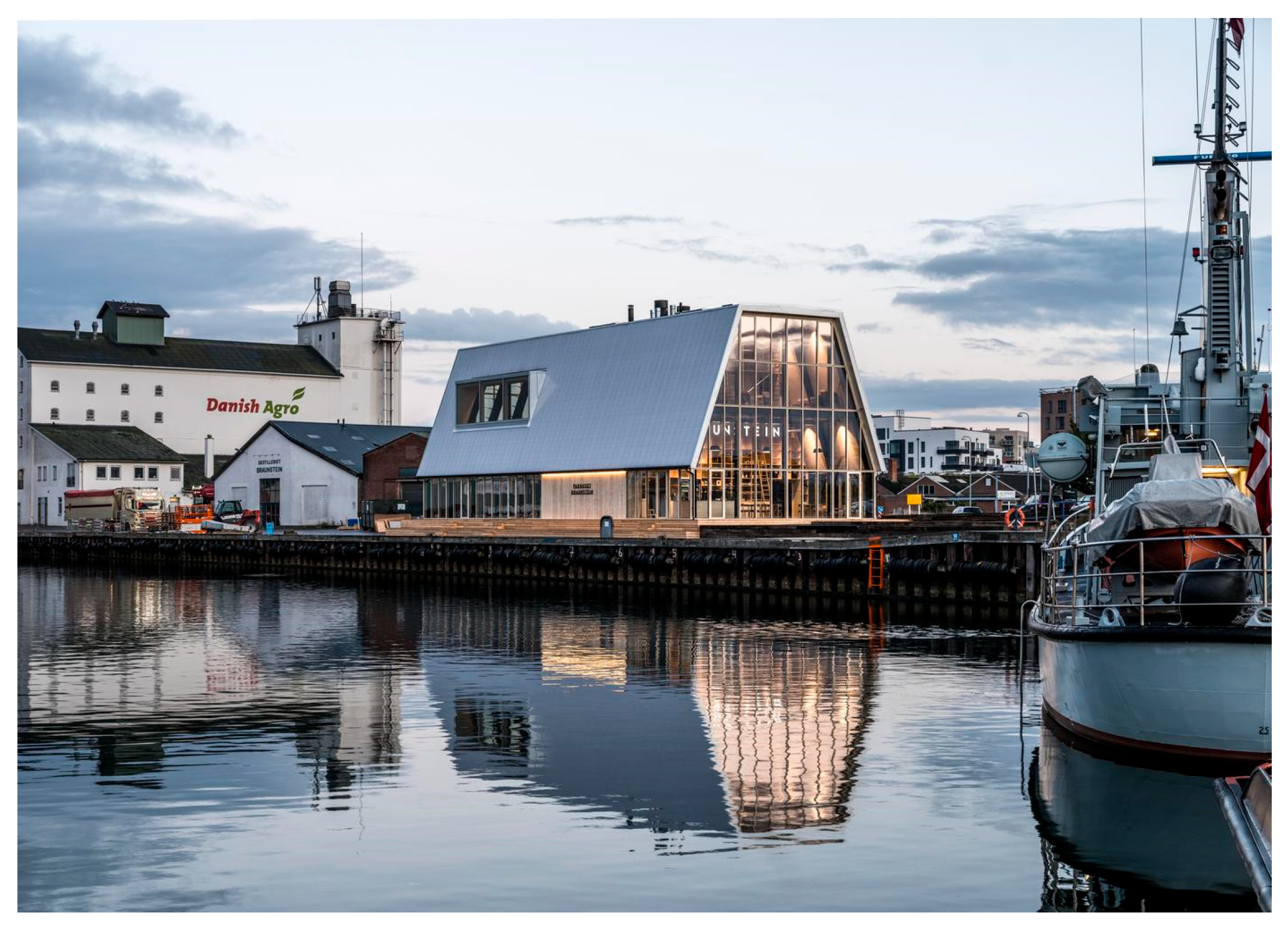
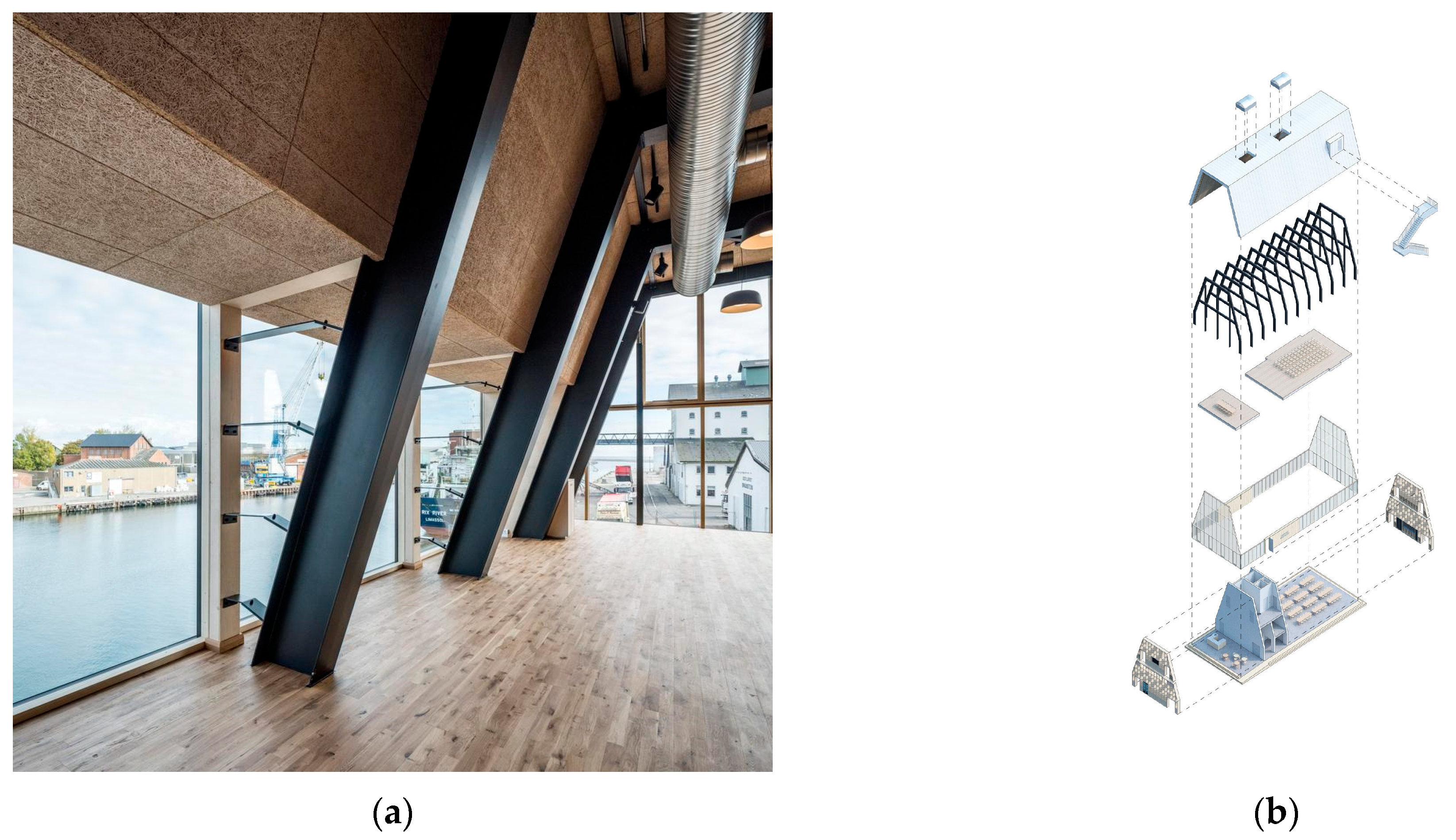
- The Braunstein Taphouse—ADEPT. Adept. Available online: https://www.adept.dk/project/the-braunstein-taphouse (accessed on 18 February 2025).
- Berman, M. All That Is Solid Melts into Air, New ed.; Verso: Brooklyn, NY, USA, 2010. [Google Scholar]


Disclaimer/Publisher’s Note: The statements, opinions and data contained in all publications are solely those of the individual author(s) and contributor(s) and not of MDPI and/or the editor(s). MDPI and/or the editor(s) disclaim responsibility for any injury to people or property resulting from any ideas, methods, instructions or products referred to in the content. |
© 2025 by the authors. Licensee MDPI, Basel, Switzerland. This article is an open access article distributed under the terms and conditions of the Creative Commons Attribution (CC BY) license (https://creativecommons.org/licenses/by/4.0/).
Share and Cite
Towers, J.; Kohler, M.; D’Olimpio, D.M.; Burchfield, C. Between Water and Land: An Urban and Architectural Response to Climate Change in Red Hook, Brooklyn. Architecture 2025, 5, 37. https://doi.org/10.3390/architecture5020037
Towers J, Kohler M, D’Olimpio DM, Burchfield C. Between Water and Land: An Urban and Architectural Response to Climate Change in Red Hook, Brooklyn. Architecture. 2025; 5(2):37. https://doi.org/10.3390/architecture5020037
Chicago/Turabian StyleTowers, Joel, Martina Kohler, David Maria D’Olimpio, and Cody Burchfield. 2025. "Between Water and Land: An Urban and Architectural Response to Climate Change in Red Hook, Brooklyn" Architecture 5, no. 2: 37. https://doi.org/10.3390/architecture5020037
APA StyleTowers, J., Kohler, M., D’Olimpio, D. M., & Burchfield, C. (2025). Between Water and Land: An Urban and Architectural Response to Climate Change in Red Hook, Brooklyn. Architecture, 5(2), 37. https://doi.org/10.3390/architecture5020037