Abstract
This article introduces a methodology for a novel data-driven computational model aimed at aiding public administrations in managing and evaluating the adaptative reuse of buildings while tackling ecological and digital challenges. Drawing from the 2030 Agenda for Sustainable Development, the study underscores the significance of innovative approaches in harnessing the economic potential of data. Focusing on Barcelona’s Ciutat Vella district, the research selects five historic public buildings for analysis, strategically positioned to spur local entrepreneurship and counteract tourism dominance. Through an extensive literature review, the article identifies a gap in computational models for building adaptative reuse and proposes a methodological framework that integrates data collection, processing, and computational modelling, underscored by GIS technology and open data sources. The proposed methodology for a computational algorithm aims to systematise spatial characteristics, assess programmatic needs, and optimise building usage, while addressing challenges such as data integration and quality assurance. Ultimately, the research presents a pioneering approach to building adaptative reuse, aimed at fostering sustainable urban development and offering replicable insights applicable to similar challenges in other cities.
1. Introduction
According to the 2030 Agenda for Sustainable Development, “Quality, accessible, timely and reliable disaggregated data will be needed (…) to drive actions, monitor and verify achievements” []. The European Political Strategy Centre (EPSC) confirms “Data is rapidly becoming the lifeblood of the global economy. It represents a key new type of economic asset. Those that know how to use it have a decisive competitive advantage in this interconnected world, through raising performance, offering more user-centric products and services, fostering innovation—often leaving decades-old competitors behind. (…) Data analytics will soon be indispensable to any economic activity and decision-making process, both public and private” [].
The importance of data is not new, and the predicted economic value that can be extracted remains as of yet largely unrealized. Following this trend, this article proposes a first approach to develop a data-driven computational model to support the public administration in the management and assessment of buildings’ adaptative reuse flow, thus simultaneously addressing both ecological and digital challenges. The measurement, optimization, and feedback to this model will facilitate the elaboration of more resilient urban agendas offering different temporal needs for citizens, making cities capable of responding more efficiently in emergency situations such as a new pandemic; at the same time that they become spaces of opportunity for the local economic development in a sustainable way.
This approach aims to promote a new city-making model, capable of mapping underused buildings and spaces, as well as developing reuse indexes that match these spaces with different public activities, facilitating also the integration of new programs capable of containing and sharing a great diversity of uses.
The article takes as a replicable sample the uses characterization of five public buildings located in the Ciutat Vella district of Barcelona. The proposal focuses on the possibilities of urban reuse applied to five large buildings from the late 19th century and early 20th century, all publicly owned and currently underutilised. These buildings lay at the threshold between the historic centre of the city and the harbour of Barcelona and have great potential for urban transformation due to their strategic location. Their adaptative reuse has the potential to address some of the city’s major challenges, such as enabling their spaces for new productive models for local entrepreneurship or the provision of useful areas for accommodation featuring various programmatic and temporal characteristics. This endeavour demands a new methodology for making the city more sustainable and based on the principles of the circular economy.
The buildings proposed as the object of study for the elaboration of the methodology presented in this article, are grouped along a 2 km linear axis formed by Paseo de Colón, Paseo de Isabel II, Paseo de Argentera, and Paseo Picasso, which can generate an innovative axis for the clustering of local entrepreneurship to recover the port area for the citizens and mitigate the effects of the over-occupation of tourist activities (Figure 1).
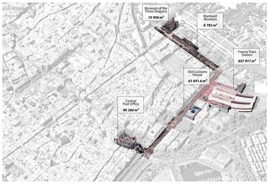
Figure 1.
Aerial view with the buildings chosen as case studies. Source: Own elaboration from Google Maps, published in [].
The buildings proposed as case studies for the application of the research methodology are: Central Post Office (1926), Old Customs House (1970), France Station (1929), Martorell Museum (1882), and Museum of the Three Dragons (1888) (Figure 2).
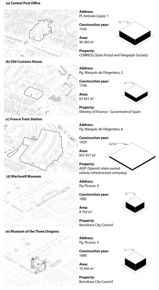
Figure 2.
Case studies selection: (a) Central Post Office (1926), (b) Old Customs House (1970), (c) France Station (1929), (d) Martorell Museum (1882), and (e) Museum of the Three Dragons (1888). Source: Authors.
Ciutat Vella is a district in which its residents can live in poor living spaces, while local entrepreneurship is drowned by rental prices marked by its centrality and its great tourist incidence. Likewise, we find that large publicly owned buildings are currently empty or underutilised. In addition, the accumulation of urban land in large property holders has worsened in the last decade and the availability of urban plots for new buildings is scarce []. The adaptative reuse or efficient use of existing public buildings can be an alternative that gives the administration-built volume available for different activities. This enables the administration to respond to the temporary needs and ambitions of citizens at all times and also gives it the ability to respond to difficult situations to predict, such as a health emergency.
To enact the vision discussed above, it is argued that a generic end-to-end data-driven approach is required to systematise the whole life-cycle process. Indeed, in today’s digital cities, groups of developers, statisticians, graphic designers, and business advisors are building advanced solutions based on data analytics such as the Barcelona Tourism Data System [], BIOCOMSC’s COVID-19 Data Portal [], Arbres de Barcelona [], or TransitBCN []. These are representatives of data-driven approaches that have a direct impact on the quest of solving major urban challenges like mobility, climate change, or well-being. Hence, this proposal leverages on such a wealth of (open) data to provide computational support to the refinement of the possible uses of buildings (i.e., the buildings’ adaptative reuse flow management). To that end, this research defines a method that (a) defines the data collection which is needed from buildings and their context; (b) yields a public and continuously evolving list of available inner spaces; and (c) creates the conditions to develop computational models to support the process of deciding the building’s space usage. Having the ability to semi-automate the process of cataloguing and deciding the reuse and transformation of existing buildings is a major novelty that will allow to scale and apply the methodology to other buildings or cities with different particularities and similar data available.
This approach to a computational model based on data for the reprogramming and the assessment of the adaptative reuse flow of obsolete buildings raises the following fundamental questions:
- How to systematise the spatial characteristics of existing buildings by leveraging external data sources?
- What programmatic needs do the surrounding users have?
- How are public buildings being used? Are there any chronicled voids in our buildings?
- How can their use be optimised via computational models?
According to the European Cohesion Policy [], to mainstream circular economy, our cities can become more sustainable and resilient through the transformation of existing buildings and their adaptative temporary reuse, favouring the well-being and quality of life of citizens, and promoting social inclusion and economic growth with respect for the environment. Currently, many cities continue to solve their space needs with new construction and consumption of territory. The European Commission approved in 2014 a package of measures to enable the circular economy (CE), including proposals to revise waste legislation to stimulate the transition from a linear economy to a circular one. Furthermore, this package included as a new challenge: the reuse and transformation of existing buildings, particularly those not used or underused, with the logic of creating new economic and social opportunities aligned with the CE principles to: (1) take advantage of the existing common heritage; (2) improve the environmental performance of buildings throughout their life cycle; and (3) propose new scenarios for urban entrepreneurship.
However, the way in which architecture is being materialised so far makes it difficult to achieve both the goals of the 2030 Agenda [] and our cities’ goals regarding sustainable, environmental, economic, and social development []. It is necessary to improve tools and methodologies using data intensively to think more carefully about how we manage, use, and reuse all the built environment that is already available, as with the rest of the natural resources.
Numerous indicators point out that the construction industry currently represents the emission of 40% of the total global greenhouse gases. Yet another challenge that must be addressed to achieve the above-mentioned goals is the current scarcity of materials due to the fact that the available resources are being used in an inefficient way, i.e., they are not being optimised. If the construction sector continues its current building practices, maintaining the same standards and materials, it is projected to consume approximately 60 billion tons of material per year from 2030 to provide housing for the future population. This trajectory raises significant concerns about material depletion resulting from current practices. For instance, the latest OECD (Organization for Economic Co-operation and Development) report estimates that there is more copper in our buildings than in natural mines. These problems are added to the fact that the construction sector is responsible for nearly a third of global waste, that is, waste that is not recycled or intelligently reused, both during construction and at the end of the life of buildings [].
The adaptative reuse of existing buildings for different activities also offers citizens and communities the opportunity to participate in the life of the city more easily. Compared to new constructions or comprehensive rehabilitation projects, adaptive reuse offers a greater opportunity to transform and reinvent urban users through citizen participation []. This approach fosters the transition towards a circular economy and a more sustainable consumption model. It is necessary to rethink cities by considering the real housing needs, as well as the needs of the economic, productive, and cultural sectors. This must be done with a global, sustainable, resilient, and inclusive vision of the city. It has been proved relevant that being able to host new functions within buildings originally designed for other activities, to accommodate flexible uses has a positive effect on the surroundings, creating a social impact through job opportunities and services [].
1.1. Literature Review
In the field of architecture, particularly with regard to publicly owned buildings, administrations have access to numerous open-source datasets, which are primarily used for diagnosing certain trends. However, these datasets are still not regularly utilised for the adaptive reuse of buildings, specifically in terms of programming and reprogramming available spaces. This article proposes to define the intensive use of available data sources to establish the conditions for the generation of computational models that contain the programming conditions buildings to offer best-fit solutions capable of relating necessary activities for local users with available public spaces.
Regarding adaptative reuse flow assessment, there are several approaches for Material Stock Assessment (MSA) and Material Flow Assessment (MFA), but the reuse flow of spaces in existing buildings is still underexplored in terms of automatisation of the process [,,,]. There are also multiple studies and initiatives describing the methodology and data needed for the reuse of spaces in abandoned or underused buildings, for example, the Atlas of recycled landscapes [], reflecting the possibility of intervention on ancient industrial areas and urban landscape; the No-void [] project, developed in 2018 by Instituto de Geografia e Ordenamento do Território da Universidade de Lisboa in Portugal, reinventing abandoned parts of the city; or the Atlas of temporary uses for empty spaces [], developed by the Barcelona City Council, establishing strategies and methodologies for the adaptative reuse. It is also worth mentioning, as an interesting initiative, the URBACT Europe [,,,], which supports cities’ management to reactivate their build environment.
The architectural reprogramming of public buildings is currently being worked on manually [], contemplating different available data sources, relating optimal relationships of use between spaces and legal imperatives set by building regulations. However, these data sources are presented in different data formats, and there is not yet a basic catalogue that allows their parameterization for intensive relational use. This article proposes a methodology to generate a data-driven computational model supported with Geographic Information System (GIS) for the generation of geolocated re-programmatic solutions. Computational tools linked to GIS have become powerful and useful for analysing and interpreting building information to evaluate circular economy strategies. The decision on the chosen study sample [,] was taken considering the potential impact to the rest of the city and the previous experience of the authors in the district, which provided valuable data about its buildings [,] and population [,] in a dense district where there is a large number of underused and empty spaces [].
1.2. Knowledge Gap
Adaptative reuse of buildings plays a key role in the construction value chain regarding the transition towards a circular economy. In order to improve the outcomes, it is necessary to implement an appropriate data-based computational model that helps public administration to manage the use of available built stock. To the authors’ knowledge, this will be a first approach that will describe and analyse an experimental method for the selective reuse of buildings. In this case, computational approaches do not intend to replace human experts. Rather, their purpose is to help administrations to have a better understanding of the parameters involved in the process of reuse flow with a view to improve a sustainable agenda for the cities in its broader sense.
In order to realise this vision, a vast collection of data must be performed. It is well-known that open-source GIS databases have continually improved in recent years due to the active and collaborative participation of governments and universities, industry, and other interested organisations. Available data offers the possibility of better understanding the distribution of population and activities in cities, possible growths, or under-utilised areas. In Spain, and specifically in Barcelona, several databases provide the input and enrichment information necessary for the cartographic modelling of buildings and their socioeconomic context. All these available data sources must be organised and structured in an appropriate way so that they can be automatically managed, integrated, and processed, providing flexibility in the incorporation of updates in the sources, as well as enabling traceability of the results to enrich the analysis. In this way, instead of basing the analysis process on independent tools for each specific task in the pipeline (from data collection to the final building reuse decisions), an end-to-end solution is required to overcome the limitations of current practices [], providing a single data analysis framework spanning the whole life cycle.
The article analyses the initial methodological stage, and it is applied and focused on the Ciutat Vella district in Barcelona as a sample that can be extrapolated to the national territory. It aims to advance in reprogramming modelling through the intensive use of a set of heterogeneous and publicly available datasets.
Having the ability to replan the building’s uses at a large scale requires getting rid of the manual arduous task of collecting, processing, and analysing the available information. As previously discussed, in digital cities, there are numerous efforts underway that generate large amounts of valuable data. By integrating these datasets with those from third parties, we can contextualise our data using additional variables and indicators, leading to more informed decision-making.
2. First Approach to a Computational Algorithm for Reprogramming the Use of Buildings
The research provides a modular methodology based on several blocks. The main elements of the methodology are structured in the following steps:
- Data Processing and Integration. The introduction of GIS cartographic data based on the methodology proposed by the EU for the reuse of buildings [] with the essential parameters in the fields of the BES (Sustainable economic well-being index, a.k.a., well-being, equity, and sustainability), the spatial characteristics and morphological/volumetric invariants, the state of conservation and protection invariants, and the energy consumption of the buildings.
- Encoding Datasets. Characterisation (size and geometric description) of the public buildings in Ciutat Vella. Programmatic systematisation of equipment uses: the introduction of possible activities in the district, in this case, Ciutat Vella, and the analysis and introduction of distribution diagrams of equipment programs in Spain (minimum sample of 300 case studies). Data source available in the archives of the Spanish Architects Institute CSCAE (see, for example, Catalonia [] or Madrid []). Dataset generation on regulations and programmatic needs.
- CM-REUSE Modelling. Design of the computational tool for the optimization of new uses in underused buildings and first modelling: sizing and geometric description of the building spaces, ranking of the elements according to structural capacity, state of conservation and heritage protection. First approach to reprogramming and reuse flow assessment [,,].
- Model feedback and extrapolation. Choice of the reuse diagram regarding best-fit optimisation options and feedback to the model by multi-objective optimisation to the tool or adjusting key parameters in the datasets. Generation of artificial intelligence.
2.1. Data Collection, Integration, and Processing
A major challenge in this approach is how to support a seamless incorporation of additional data sources into the pipeline. To that end, a systematic data governance process encompassing data management and analysis is required in order to support the rest of the activities. Such an approach has the goal of automating the process’ life cycle and provides flexibility both in the management of data and in its processing.
CM-REUSE deploys a layered data infrastructure which will first support the ingestion of data from the different sources, storing them in a Landing Zone. Then, the data should be transformed to a canonical structured format, such as a relational database, in the Formatted Zone. Those formatted data are then pre-processed to obtain a homogeneous representation of the different sources that can then be meaningfully integrated in the Exploitation Zone. Here, the data will be stored in the most appropriate form for the desired analysis, namely, relational and GIS. In the Exploitation Zone, the data will already be prepared to be processed by the Data Analysis, part of the infrastructure namely Space Reprogramming and Artificial Intelligence Enrichment.
One key component in the infrastructure is the traversal Data Governance Layer, a data-centric component consisting of a semantic knowledge base that keeps track of all the necessary metadata to identify, locate, manipulate, and publish data, as well as traceability information on how the data has been transformed along the pipeline. This layer serves as the backbone of the data infrastructure and facilitates the automation of its processes. It contains essential knowledge about all the data within the infrastructure, as well as how this data has been processed to generate the system’s output.
Design and development of data collectors and encoders: Given the large number and heterogeneity of data sources considered in this project, we propose to adopt the notion of Data Collectors, which are programs responsible for accessing specific data sources, extracting data from them, and moving the data into the data infrastructure. When the fetched data cannot be automatically processed, for instance, due to variability in the content or structure, we propose the adoption of Encoders, which are programs in charge of homogenising such data to enable integrated analysis (Figure 3).
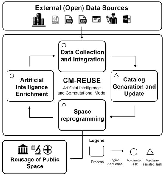
Figure 3.
Proposed methodology for the automatization of adaptative reuse of buildings. High-level overview of the framework. Source: Own elaboration.
Inspection and qualitative evaluation of buildings (due diligence): Study of the constructive and structural characteristics and the heritage elements to be protected (Table 1).

Table 1.
Selection requirements for the Due Diligence Assessment.
Compilation of data on buildings’ energy consumption: The energy efficiency certificates (CEE) of buildings [] offer valid geolocated data to assess the possible environmental impacts of buildings and their consumption of resources. CEE is also used in the construction sector, where it is a crucial part of assessing the environmental sustainability of buildings (Table 2).
Table 2.
Compilation of data available about buildings’ energy consumption.
Evaluation of the socioeconomic context. BES (equitable and sustainable well-being): The BES encompasses a system of indicators in 12 domains to provide more comprehensive information with contextual conditions for decision-making. In this project, the BES methodology will be applied to detect needs for activities/uses in the district and also to detect possible users in the community. Special attention will be given to the demographic distribution of the data and most particularly to the probable differences between sexes on the values of the indicators. This approach, which incorporates a gender perspective, will enhance the understanding of economic and social phenomena. It will also shed light on the distribution—along with potential inequalities—between genders, with implications for decision-making and the planning and allocation of resulting activities (Table 3).
Table 3.
Evaluation of the socioeconomic data.
2.2. Encoding Datasets
At the end of the first phase the contextual data and the information available about each building of the sample will be able to be used.
The performance of algorithms is heavily dependent upon the availability of big training datasets. In the growing field of Computational dependent Architecture, there is a huge need for the collection/creation of comprehensive labelled datasets. In this second phase, its interior spaces will be distributed for possible reprogramming based on four descriptive classifications: (1) Core space, (2) Satellite space (dependent or serving the core space), (3) Relational space (stairs, corridors, elevators, etc.) and (4) Access.
This work will also be carried out by studying the functional diagram based on these four parameters of the five case studies and will be crossed with the lists of space requirements of the following functional programs: civic centre, primary care centre, day centre for the elderly, nursery, primary school, secondary school, theatre, artistic accommodation, business incubator, gym, museum, library, market.1 This database will be extensive and open for the introduction of new equipment (Table 4).
Table 4.
Recompilation of data of the case studies.
To generate a cartographic base for the detection of empty or underused spaces, it is proposed to carry out a GIS cartographic base of the current state of all public property buildings in the Ciutat Vella district and the beginning of the establishment of the parameters. The determination of the constructive and structural characteristics and the study of protected heritage elements will be unified with the date of space available to be used.
The BES analysis and the socioeconomic data collected will also frame the activities needed to be taken into account.
The encoding of the databases is an essential phase, since, as mentioned above, the information databases are not always at the same scale (parcel, census section, etc.), nor do they generate the same types of data (geometric, statistical, etc.), as seen in previous studies []. Therefore, the main objective of this phase is the development of a centralised database with comparable elements; that is, to develop a database that refers to each public building and that contains all the information of its own and contextual characteristics in an updated, precise, and exact way. Merging the data geographically also makes it easy to update the database when new information is updated or appears.
2.3. Computational Tool Design
Up to this stage, the interior spaces of each building in the sample are described, the programming datasets for public facilities are introduced, and mechanisms to detect needs for use and potential users in the district are established. The objective in this third stage is twofold: first, to determine and detect programmatic needs in the district, and second, to give possible results to various schemes to establish an adaptative reuse flow in the buildings.
Firstly, we endeavour to meticulously discern and evaluate the programmatic requirements inherent to the district’s dynamic socioeconomic fabric. By discerning these needs, we aim to forge a blueprint for adaptive reuse strategies that seamlessly integrate with the existing architectural framework.
Secondly, we aspire to proffer a spectrum of potential outcomes, thereby facilitating informed decision-making processes aimed at optimising resource allocation and enhancing the overall livability quotient of the district. The model should propose several scenarios that can be adapted to the available spaces through algorithms that offer different Best-fit results, minimising the wastage of spaces according to each building or complex and programmatic structure.
The development of these algorithms represents a seminal phase in our research, as it necessitates a synthesis of computational techniques with domain-specific knowledge from the fieldwork. By calibrating our model to offer best-fit solutions across multiple dimensions—encompassing programmatic, regulatory, and geometric considerations—we seek to engender a paradigm shift in the adaptative reuse of buildings.
Building upon this data, we propose the implementation of a tool designed to streamline the reprogramming process while simultaneously harnessing the predictive power of multi-objective optimization methods. This tool was conceived to empower stakeholders with the requisite insights needed to navigate the complex terrain of urban redevelopment with confidence and precision. In order to support the application of the previously introduced best-fit algorithms over the gathered data, we aim to design a user-friendly tool that presents the most relevant information from the catalogue and executes the reprogramming algorithms. Considering that each best-fit reprogramming solution might differ from the others, we will consider the application of multi-objective optimization methods.
Due to the qualitative nature of the data considered in these cases, it might be necessary to reconsider some of the dataset choices, mappings, or readjust parameters in the multi-objective optimization phase. Consequently, we anticipate the need for iterative refinement and readjustment of key parameters throughout the interpretative phase.
In sum, the journey from conceptualization to implementation is fraught with challenges and uncertainties. Yet, it is through the relentless pursuit of knowledge and innovation that we aspire to transcend these barriers and chart a course towards a more inclusive, sustainable, and resilient urban future.
3. Discussion
This study introduces a novel approach for adaptive reuse of underutilised public buildings by developing a methodology and a use of data criteria to generate a computational model that can ease the task of adaptative reuse of publicly owned buildings. This methodology for a model provides a path for future predictions/recommendations on replanning over new buildings. The first step of such a data analytics pipeline consists of feature engineering, which is the extraction and selection of the most relevant features for the task, so that later on models can be generated.
One of the main virtues of this study shows a significant promise in its ability to propose adaptive reuse solutions for buildings that align with sustainable development and urban resilience goals. By automating the collection and processing the open data critically selected on space utilisation and socioeconomic indicators, the model that will be developed from it could offer a practical tool for public administrations seeking to revitalise urban areas while maintaining the architectural integrity of heritage buildings. The future digitization and systematisation of these processes must be able to facilitate the transition towards a more sustainable economy, where the existing heritage is seen as a resource available within the circular economy. The impacts can be summarised in the following results:
This database will constitute a digital repository of the existing heritage. The European Commission has recently launched a European Strategy for Data aiming to make the EU a role model for a society empowered by data []. In the EC vision, the innovation driven by data shall make benefits especially for citizens. The way of collecting and processing data should place the individuals in the centre of the interest in accordance with the European values.
Consequently, the future development of a computational model for building reuse is central to the digital transformation. This model aims to contribute to the city’s data strategy by placing data science at the heart of this transformation. By 2025, 50% of data scientist activities will be automated by AI, easing the acute talent shortage [,].
The research, due to its interdisciplinary and transversal nature, hopes to achieve relevant scientific-technical contributions and impacts, especially in the fields of architecture, computing, and urban sociology, but its implications can potentially be extrapolated to other fields of knowledge, such as economics, anthropology, political science, and engineering, among other disciplines. The expected scientific-technical impacts will enhance the digital and ecological transition through the digitization of the built heritage environment and its data management for decision-making optimization on building adaptative reuse. In this sense, the need for cities to adopt management models in line with the CE and the quality of life of its inhabitants is also addressed [].
The analysis buildings such as Martorell Museum and France Station underscore the model’s capability to propose multifunctional spaces that balance the needs of local communities with those of the tourism sector. This is aligned with the broader discussions in the literature on adaptive reuse and urban resilience, which emphasize the need for flexible, multifunctional spaces that can accommodate changing socioeconomic and environmental conditions [].
In contrast, the analysis for more spatially constrained and legally protected buildings, such as the Old Customs House and the Old Post Office, highlight the limitations of adaptive reuse in certain contexts. Despite these challenges, a computational model managed to generate proposals that respected the buildings’ heritage status while enhancing their utility through the incorporation of cultural and educational programs. This corresponds with current trends in heritage preservation that promote sustainable interventions in historical structures [].
Another innovative aspect of the methodology is its focus on giving the user or resident a proactive central role, considering their living, economic, and social conditions. This approach aims to ensure that users are both a means and a beneficiary of the project’s results, ultimately promoting the regeneration of activities and programs for the use of public buildings. Another contribution is the development of geospatial data systems, computer analysis tools that can be used in future public policies and planning programs by state public administrations. This fact reinforces the need for replicability and extrapolation of the methodologies developed and the definitions achieved by the project in other urban contexts, extending the repercussion of its results in improving the quality of life of the population on a broader scale.
The successful application of this computational model has significant implications for public policy and urban planning, particularly in cities like Barcelona, which face increasing pressure from tourism and a shortage of affordable space for local communities. The model provides a scalable solution for cities grappling with the challenge of underutilized historic buildings. By leveraging publicly available datasets, it presents a cost-effective and efficient tool for optimizing space reuse, potentially reducing the need for new construction and minimizing environmental impact [].
These findings also align with the Barcelona Plan for Sustainable Tourism and similar urban regeneration efforts aimed at balancing tourism with the needs of local residents. The model’s focus on fostering local entrepreneurship, cultural spaces, and public services is particularly relevant in districts like Ciutat Vella, where gentrification and the over-saturation of tourism have marginalized long-standing communities.
Additionally, the model’s integration of socioeconomic data with spatial analysis ensures that the reuse proposals are not only architecturally and economically feasible but also socially equitable. This is critical in preventing further displacement of local residents and ensuring that adaptive reuse contributes to broader goals of urban equity and resilience [].
4. Conclusions
While the methodology for a computational model has shown significant potential, several limitations must be acknowledged. The accuracy of the model is contingent upon the quality and completeness of the open data used, which may not fully reflect the dynamic socioeconomic and demographic conditions of rapidly changing urban neighborhoods. Future versions could incorporate real-time data streams or employ machine learning algorithms to enhance predictive accuracy. Moreover, the model currently focuses primarily on space utilization and socioeconomic optimization but does not take into account the financial costs or economic feasibility of adaptive reuse projects.
Finally, the model’s scalability across different urban contexts will require further studies. While it performed well in the Barcelona case studies, other cities with different regulatory frameworks, socioeconomic conditions, and architectural types may pose new challenges. Nonetheless, the adaptability of the methodology to various datasets suggests it has broad potential for application in other urban environments facing similar challenges of underutilization and heritage preservation.
This study provides a first-of-its-kind methodology for a computational model for optimizing the adaptive reuse of public buildings, demonstrating its utility in the context of Barcelona’s historic Ciutat Vella district. By automating data collection and analysis, the methodologies open the possibility for a model that can offer public administrations a powerful tool for sustainable urban planning, one that integrates spatial, economic, and social considerations into the reuse process.
The analysis of five historic buildings in Barcelona reveals both its strengths and limitations, but overall, it represents a significant step forward in the field of adaptive reuse. As cities around the world grapple with the challenges of climate change, population growth, and tourism pressures, tools like this method for a computational model will become increasingly important in ensuring that urban environments remain resilient, inclusive, and sustainable.
The next steps for this research will focus on developing the model to explore the potential of this model to inform public policy and urban planning in cities, helping to ensure that adaptive reuse becomes a cornerstone of sustainable urban development worldwide.
Author Contributions
Conceptualization, M.D.-R., C.C. and D.L.L.; Methodology, M.D.-R., C.C., D.L.L., S.N. and A.Q.; Software, S.N. and A.Q.; Investigation, M.D.-R., C.C. and D.L.L.; Resources, M.D.-R., C.C. and D.L.L.; Data curation, M.D.-R., C.C. and D.L.L.; Writing—original draft preparation, M.D.-R., C.C. and D.L.L.; Writing—review and editing, M.D.-R., C.C., D.L.L., S.N. and A.Q.; Visualization, M.D.-R., C.C., D.L.L., S.N. and A.Q.; Supervision, M.D.-R., C.C., D.L.L., S.N. and A.Q.; Project administration, M.D.-R., D.L.L. and C.C.; Funding acquisition, M.D.-R., D.L.L. and C.C. All authors have read and agreed to the published version of the manuscript.
Funding
Pla de Ciència 2020de l’Ajuntament de Barcelona. Expedient 64-20S08727/28/29. Evaluation and intervention strategies for urban regeneration and mitigation of energy poverty in Barcelona and Bilbao. ENER-REGEN. PID2022-142352OB-I00 (Còssima Cornadó). The Spanish Ministerio de Ciencia e Innovación under project PID2020-117191RB-I00/AEI/10.13039/501100011033 (Sergi Nadal and Anna Queralt). Horizon Europe CyclOps (GA.101135513). (Sergi Nadal and Anna Queralt). Còssima Cornadó, Marta Domènech and Anna Queralt are Serra Hunter Fellows.
Institutional Review Board Statement
Not applicable.
Informed Consent Statement
Not applicable.
Data Availability Statement
Data will be available in: https://dataverse.csuc.cat/ (accessed on 13 March 2024).
Conflicts of Interest
The authors declare no conflicts of interest.
Note
| 1 | All these data should be taken from the archives of the Spanish Institute of Architecture (CSCAE). |
References
- Economic and Social Council-United Nations Economic Commission for Europe How to Implement the Monitoring System for the Sustainable Development Goals UN Documents and Decisions Relevant to Statistics for SDGs and the Regional Dimension; United Nations: Geneva, Switzerland, 2021.
- European Political Strategy Centre (European Commission). Enter the Data Economy. EU Policies for a Thrivin Data Ecosystem; EPSC Strategic Notes: Singapore, 2017. [Google Scholar]
- Domènech Rodríguez, M.; López, D.L.; Cornadó, C. The Role of Cultural Heritage in Urban Reuse. HERITAGE2022 International Conference on Vernacular Heritage: Culture, People and Sustainability; Editorial Universitat Politècnica de València: Valencia, Spain, 2022. [Google Scholar] [CrossRef]
- Cornadó, C.; Vima-Grau, S.; Garcia-Almirall, P. Pre-Diagnosis Protocol for Large Residential Building Stock. The Case of Barcelona’s Vulnerable Areas; Springer: Berlin/Heidelberg, Germany, 2021; pp. 123–155. [Google Scholar] [CrossRef]
- Tourism Data System. Available online: https://barcelona.tourism-data-system.cat/ (accessed on 13 March 2024).
- Covid Actual—Computational Biology and Complex Systems. BIOCOMSC—UPC. Universitat Politècnica de Catalunya. Available online: https://biocomsc.upc.edu/en/covid-19 (accessed on 13 March 2024).
- Arbres de Barcelona. Available online: https://arbres.orga.cat/ (accessed on 13 March 2024).
- TransitBCN. Available online: http://transit.lovelymaps.com/ (accessed on 18 March 2024).
- Ministry of Economy and Development Hellenic Republic. Mainstreaming Circular Economy as an Eligible Area into the Post 2020 Cohesion Policy and Corresponding Funds; Ministry of Economy and Development Hellenic Republic: Athens, Greece, 2018.
- European Commission. Próximas Etapas Para Un Futuro Europeo Sostenible. Acción Europea Para La Sostenibilidad; European Commission: Strasburg, France, 2016. [Google Scholar]
- Ajuntament de Barcelona. L’Agenda 2030 de Barcelona Fites i Indicadors Clau Informe Presentat al Plenari de l’Ajuntament de Barcelona Octubre de 2020; Ajuntament de Barcelona: Barcelona, Spain, 2020. [Google Scholar]
- Block, P.; Van Mele, T.; Rippmann, M.; Ranaudo, F.; Calvo Barentin, C.; Paulson, N. Redefining Structural Art: Strategies, Necessities and Opportunities. Struct. Eng. 2020, 98, 66–72. [Google Scholar] [CrossRef]
- Domènech-Rodríguez, M.; Cornadó, C.; Vima-Grau, S.; Piasek, G.; Varela-Conde, A.; Ravetllat Mira, P.J. Co-Design and Co-Manufacturing: A Multidisciplinary Approach through Small-Scale Architectural Experiences in Barcelona. Buildings 2023, 13, 1159. [Google Scholar] [CrossRef]
- Bellamy, R.; Palumbo, A. From Government to Governance. Gov. Gov. 2017, 1–506. [Google Scholar] [CrossRef]
- Augiseau, V.; Barles, S. Studying Construction Materials Flows and Stock: A Review. Resour. Conserv. Recycl. 2017, 123, 153–164. [Google Scholar] [CrossRef]
- Müller, E.; Hilty, L.M.; Widmer, R.; Schluep, M.; Faulstich, M. Modeling Metal Stocks and Flows: A Review of Dynamic Material Flow Analysis Methods. Environ. Sci. Technol. 2014, 48, 2102–2113. [Google Scholar] [CrossRef] [PubMed]
- Lanau, M.; Liu, G.; Kral, U.; Wiedenhofer, D.; Keijzer, E.; Yu, C.; Ehlert, C. Taking Stock of Built Environment Stock Studies: Progress and Prospects. Environ. Sci. Technol. 2019, 53, 8499–8515. [Google Scholar] [CrossRef] [PubMed]
- Röck, M.; Baldereschi, E.; Verellen, E.; Passer, A.; Sala, S.; Allacker, K. Environmental Modelling of Building Stocks—An Integrated Review of Life Cycle-Based Assessment Models to Support EU Policy Making. Renew. Sustain. Energy Rev. 2021, 151, 111550. [Google Scholar] [CrossRef]
- De Poli, M.; Incerti, G. Atlante Dei Paesaggi Riciclati; Skira: Milan, Italy, 2014. [Google Scholar]
- Instituto de Geografia e Ordenamento Do Território Da Universidade de Lisboa. Available online: http://www.ceg.ulisboa.pt/novoid/ (accessed on 18 March 2024).
- Àrea de Territori i Sostenibilitat. Gerència de Serveis d’Habitatge, U. i activitats. D. de B. GUIA Metodològica Projectes d’activació d’espais Buits per a Usos Temporals; Diputació Barcelona: Barcelona, Spain, 2015. [Google Scholar]
- Sub>urban|Urbact.Eu. Available online: https://urbact.eu/networks/suburban (accessed on 19 March 2024).
- REFILL|Urbact.Eu. Available online: https://urbact.eu/networks/refill (accessed on 19 March 2024).
- 2nd Chance|Urbact.Eu. Available online: https://urbact.eu/networks/2nd-chance (accessed on 19 March 2024).
- Domènech Rodríguez, M.; López López, D.; Cornadó, C. Cohabitem Barcelona: Cinc Casos d’estudi a Ciutat Vella per a La Reutilització Urbana i El Foment de Models Productius Innovadors. Bachelor’s Thesis, Universitat Politècnica de Catalunya, Barcelona, Spain, 2021. [Google Scholar]
- Vima-Grau, S.; Cornadó, C.; Ravetllat, P.-J.; Garcia-Almirall, P. Multiscale Integral Assessment of Habitability in the Case of El Raval in Barcelona. Sustainability 2021, 13, 4598. [Google Scholar] [CrossRef]
- Piasek, G.; Vima-Grau, S.; Garcia-Almirall, P. Ante La Amenaza, Organización. Representaciones y Estrategias de Asociaciones Vecinales Sobre La Situación Socio-Residencial de Barrios Vulnerables. ACE Archit. City Environ. 2022, 16, 48. [Google Scholar] [CrossRef]
- Piasek, G.; Grau, S.V.; Rubio, R.S.; Cornadó, C.; Almirall, P.G. Revisión de políticas de vivienda en contextos de vulnerabilidad socio-residencial. cinco barrios de barcelona. Biblio3W Rev. Bibliográfica De Geogr. Y Cienc. Soc. 2022, 27. [Google Scholar] [CrossRef]
- Gröger, C. There Is No AI without Data. Commun. ACM 2021, 64, 98–108. [Google Scholar] [CrossRef]
- Handbook on Sustainable and Circular Re-Use of Spaces and Buildings|FUTURIUM|European Commission. Available online: https://ec.europa.eu/futurium/en/circular-economy/handbook-sustainable-and-circular-re-use-spaces-and-buildings-0.html (accessed on 18 March 2024).
- Arxiu Històric|COL·LEGI D’ARQUITECTES DE CATALUNYA. Available online: https://www.arquitectes.cat/es/arquitectes/departaments/arxiu (accessed on 18 March 2024).
- COAM-Fondos y Legados. Available online: https://www.coam.org/es/fundacion/servicio-historico/fondos-y-legados (accessed on 18 March 2024).
- Latham, D. Creative Re-Use of Buildings; Routledge: Oxfordshire, UK, 2000. [Google Scholar]
- Douglas, J. Building Adaptation; Elsevier Science & Technology Books: Amsterdam, The Netherlands, 2002; p. 545. [Google Scholar]
- Kincaid, D. Adapting Buildings for Changing Uses: Guidelines for Change of Use Refurbishment; Spon Press: London, UK, 2003; ISBN 9780419235705. [Google Scholar]
- Generalitat de Catalunya Hipermapa. Available online: https://sig.gencat.cat/visors/hipermapa.html (accessed on 18 March 2024).
- Garcia-Almirall, P.; Cornadó, C.; Vima-Grau, S.; Blanco Álvarez, A.; Bosch, P.; Pujadas Álvarez, P. Residential Vulnerability of Barcelona: Methodology Integrating Multi-Criteria Evaluation Systems and Geographic Information Systems. Sustainability 2021, 13, 13659. [Google Scholar] [CrossRef]
- European Commission European Data Strategy. Available online: https://ec.europa.eu/info/strategy/priorities-2019-2024/europe-fit-digital-age/european-data-strategy (accessed on 18 March 2024).
- What Data Scientists Really Do, According to 35 Data Scientists. Available online: https://hbr.org/2018/08/what-data-scientists-really-do-according-to-35-data-scientists (accessed on 18 March 2024).
- Mària, M. Estrategias de Reuso Adaptativo en Ciudades; Fundación Arquitectura Contemporánea: Madrid, Spain, 2022; ISBN 978-8417905290. [Google Scholar]
- Monteys, X.; Fuertes, P.; Roca, A.G. Atlas del Aprovechamiento Arquitectónico; Editorial Gustavo Gili: Barcelona, Spain, 2018; ISBN 978-8425229578. [Google Scholar]
- Austin, R.L.; Woodcock, D.G.; Steward, W.C.; Forrester, R.A. Adaptive Reuse: Issues and Case Studies in Building Preservation; Van Nostrand Reinhold Company: London, UK, 1988; ISBN 978-0442237849. [Google Scholar]
- Ajuntament de Barcelona (2022). Plan de Sostenibilidad Turística en Destinos (PSTD). Barcelona: Ajuntament de Barcelona. Available online: https://ajuntament.barcelona.cat/turisme/sites/default/files/en_gb_pstdb_presentacio_221214.pdfl (accessed on 17 September 2024).
- Peirò, M. Crisis habitacional en Barcelona y la Expansión del Turismo; Fundación César Manrique: Madrid, Spain, 2020; ISBN 978-8415047334. [Google Scholar]
Disclaimer/Publisher’s Note: The statements, opinions and data contained in all publications are solely those of the individual author(s) and contributor(s) and not of MDPI and/or the editor(s). MDPI and/or the editor(s) disclaim responsibility for any injury to people or property resulting from any ideas, methods, instructions or products referred to in the content. |
© 2024 by the authors. Licensee MDPI, Basel, Switzerland. This article is an open access article distributed under the terms and conditions of the Creative Commons Attribution (CC BY) license (https://creativecommons.org/licenses/by/4.0/).