Abstract
Recent advancements in aviation and automation technologies have catalyzed the emergence of Urban Air Mobility (UAM), an innovative transportation paradigm involving the use of automated vertical take-off and landing aircraft for intra-city passenger travel. Despite growing global interest, the development and application of integrated geospatial frameworks for UAM infrastructure planning—particularly vertiport siting—remain limited. Thus, this study proposes a three-stage geospatial analysis framework, which consists of (1) Suitability analysis, employing multi-criteria decision-making techniques; (2) Regulation analysis, which screens out parcels restricted by aviation safety standards, land-use policies, and other statutory constraints; and (3) Location-allocation analysis, which spatially optimizes vertiport distribution in accordance with urban master plans and strategic transport priorities. Then, this framework is empirically applied to two South Korean UAM pilot sites—Busan and Jeju. The findings reveal that high-suitability areas are predominantly concentrated in dense urban cores with strong multimodal connectivity and mixed land-use configurations. However, a significant proportion of these zones are rendered infeasible due to regulatory exclusions, such as military flight paths and restricted airspace. Additionally, areas with lower suitability—often home to marginalized populations—raise critical equity concerns. This study contributes to the advancement of urban geospatial analytics by presenting a replicable methodological framework for vertiport site selection, while offering strategic insights to inform early-stage UAM deployment initiatives.
1. Introduction
Since the early 20th century, the concept of urban aerial transportation—such as the notion of “flying cars”—has intrigued inventors and futurists alike [1]. Recent advancements in electrification, automation, and digital connectivity have transformed these speculative ideas into viable technological trajectories, giving rise to the emerging field of UAM [2]. Particularly, the integration of real-time, information-enabled platforms—akin to those utilized by transportation network companies like Uber and Lyft—holds the potential to facilitate on-demand aerial services, enabling new business models and operational paradigms [3]. UAM envisions a safe, sustainable, equitable, and cost-effective air transportation system that accommodates intra- and inter-urban functions, including passenger mobility, cargo delivery, and emergency response operations [4,5,6,7]. As part of a multimodal transport ecosystem, UAM offers several prospective benefits: reduced surface-level congestion, decreased travel times through aerial mode shifts, and enhanced environmental performance via electric vertical take-off and landing aircraft [8]. Additionally, contrary to early assumptions that UAM may be an luxury service, recent discourse has highlighted its potential to become broadly accessible and affordable, thereby improving transportation equity and contributing to overall urban quality of life [9].
However, the deployment of UAM infrastructure in complex urban environments presents critical planning and operational challenges. Chief among these is the spatial siting of vertiports—fixed nodes enabling takeoff, landing, and passenger interface—which directly impacts system efficiency, public acceptability, and network viability. Empirical research identifies multiple factors influencing vertiport siting, including land use compatibility, multimodal accessibility, regulatory compliance, and airspace management constraints [10]. Ineffective siting strategies may result in increased last-mile travel times, heightened safety concerns, operational inefficiencies, and diminished public trust in this emerging mode of transport [11]. While much of the existing literature has focused on technical or regulatory issues—such as noise mitigation standards, airspace restrictions, or vertiport design specifications [12,13]—less emphasis has been placed on developing spatially explicit, context-sensitive methodologies that account for institutional and urban planning constraints.
Therefore, this study proposes a three-stage geospatial framework for UAM vertiport planning that systematically integrates spatial, regulatory, and strategic considerations. The proposed framework consists of: (1) suitability analysis, which evaluates spatial grids using multi-criteria decision-making to identify optimal areas; (2) regulation analysis, which eliminates parcels that violate aviation safety, zoning, or land-use regulations; and (3) location-allocation analysis, which strategically allocates vertiport sites in alignment with urban master plans and transport policy goals. This methodological framework is applied to two UAM pilot regions in South Korea—Jeju and Busan—both of which represent contrasting urban typologies and are central to the national UAM implementation roadmap. By analyzing these spatially and functionally distinct contexts, this research demonstrates the applicability and robustness of the framework in informing feasible and policy-aligned vertiport siting strategies. The findings contribute to the broader discourse on sustainable urban mobility innovation, offering empirical insights and practical tools for planners, policymakers, and industry stakeholders shaping the future of UAM.
2. Related Works
The theoretical underpinnings of contemporary spatial methodologies for infrastructure siting are firmly rooted in location theory, accessibility planning, and GIS-based suitability modeling, particularly through Multi-Criteria Evaluation (MCE) frameworks [14,15,16,17,18]. MCE suitability analyses are generally designed to assess both the constraints and opportunities of land use by synthesizing social, economic, environmental, and physical indicators [19]. Such approaches have been widely adopted in the siting of transportation infrastructure—ranging from traditional bus depots and mass transit terminals to emerging facilities such as electric vehicle charging stations and micro-mobility hubs—through the integration of spatially heterogeneous layers, each normalized and weighted based on domain-informed importance, to produce composite suitability surfaces [20,21,22,23].
In this regard, a few recent studies have attempted to explore UAM vertiport locations, which can be categorized into two primary streams. The first body explores the key factors influencing vertiport placement and their relative importance [10]. For instance, a comprehensive review by Mendonca et al. [24] synthesized the multifaceted dimensions influencing vertiport placement, including regulatory frameworks, forecasted demand, infrastructure costs, equity considerations, safety and security protocols, vertiport configurations, utility provisions, and spatial accessibility. Similarly, Kim et al. [25] highlighted the centrality of socio-economic factors, noise sensitivity, and integration with existing transport modes as determinants of public acceptance and planning viability. These studies typically employ qualitative or semi-quantitative methods—such as the Analytic Hierarchy Process (AHP) and Focus Group Interviews (FGIs)—to extract expert consensus on decision priorities. While these methods provide strategic-level insights, they lack spatial precision and are insufficient for high-resolution, site-specific analysis.
The second stream emphasizes data-driven spatial methodologies to identify potential vertiport locations. Utilizing Geographic Information Systems (GIS) and spatial optimization models, this line of inquiry moves beyond conceptual factor identification toward empirically grounded site selection. For example, Fadhil [26] implemented a raster-based suitability analysis in ArcGIS to assess urban areas like Munich and Los Angeles, concluding that high-rent business districts, transportation interchanges, and airfield proximities were most suitable for early UAM adoption. Villa [27] adopted a hub location optimization model for the city of Chicago, identifying clusters of viable sites aligned with population density and network accessibility. In the Korean context, Jeong et al. [12] applied k-means clustering using commuter volume data to propose candidate sites in the Seoul Metropolitan Area; however, their model considered only a single demand-side variable and lacked integration with legal and physical constraints.
Despite the growing body of literature exploring vertiport siting and UAM deployment strategies, a critical methodological gap persists in the integration of spatial analytics with institutional, regulatory, and implementation realities. While many studies effectively leverage geospatial tools to identify spatially optimal locations for vertiport infrastructure, they often do so in isolation from the complex legal, administrative, and socio-political environments in which these facilities should operate. In particular, few existing models incorporate statutory exclusion zones, such as restricted airspace, military operation areas, or controlled flight corridors. Likewise, land-use regulations, zoning codes, noise abatement protocols, and land acquisition constraints are frequently overlooked in analytical workflows. This lack of integration results in planning outputs that may appear optimal from a purely spatial standpoint but are ultimately institutionally infeasible or operationally nonviable.
This research gap is especially pronounced in highly regulated urban contexts like South Korea, where UAM initiatives are closely tied to broader smart city programs and national transportation strategies. Here, land development is subject to rigorous control, and the implementation of UAM infrastructure must align with overlapping regulatory jurisdictions and policy priorities. Consequently, suitability models that ignore these constraints risk producing results with limited practical applicability or political legitimacy. Therefore, there is a clear need for a more holistic geospatial planning framework that not only identifies high-potential sites but also embeds legal, regulatory, and operational filters into the spatial decision-making process. Bridging this gap is essential for transitioning from conceptual feasibility studies to actionable implementation plans in the evolving field of UAM infrastructure planning.
3. Materials and Methods
To address the aforementioned research gaps, this study adopts a methodologically rigorous and policy-sensitive approach to UAM vertiport site selection. By systematically acquiring and analyzing spatial and regulatory data that reflect the multifaceted characteristics of urban environments, the study aims to bridge the divide between theoretical modeling and real-world feasibility. A key contribution lies in the parcel-level identification of feasible vertiport locations through the integration of statutory constraints, land-use policies, and urban development guidelines. This comprehensive geospatial framework yields outputs that are not only analytically robust but also operationally actionable, thereby providing practical insights to support evidence-based decision-making in the planning and implementation of UAM infrastructure.
3.1. Study Area
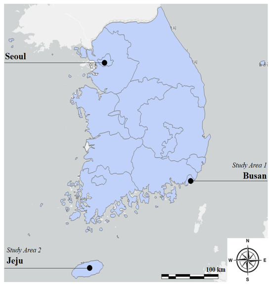
This study examines two urban contexts in South Korea—Busan and Jeju—to evaluate the applicability and adaptability of the proposed three-stage geospatial analysis framework for UAM vertiport siting (see Figure 1). Busan, a major metropolitan hub with a complex and dense transportation network, represents a high-density urban environment with advanced multimodal connectivity (see Table 1). In contrast, Jeju, a prominent island destination characterized by dispersed development and seasonal tourist influxes, embodies a lower-density, tourism-driven setting. The selection of these two case areas allows for a comparative assessment across diverse urban typologies.
Figure 1.
Locations of Study Areas.

Table 1.
Key Characteristics of the Two Study Areas.
3.2. Three-Stage Geospatial Analysis Framework
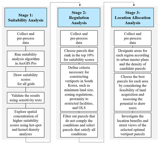
This study develops the three-stage geospatial analysis framework (Figure 2) to systematically address the complex challenges associated with optimal UAM vertiport location selection. This sequential structure ensures a progressive refinement of potential locations, balancing operational feasibility, regulatory compliance, and urban planning considerations. Unlike conventional single-stage spatial methodologies [12], this framework systematically narrows down site selection, providing a practical and adaptable solution for UAM vertiport implementation in diverse urban environments. The framework integrates:
Figure 2.
Overall Process of the Three-Stage Geospatial Analysis Framework.
- (Stage 1) Suitability Analysis—Identifying high-potential areas by selecting grids with the top 10% suitability scores, incorporating factors such as population density, land use diversity, and transportation connectivity.
- (Stage 2) Regulation Analysis—Filtering out locations that do not comply with vertiport construction laws, aviation regulations, and land-use policies, ensuring feasibility within legal constraints.
- (Stage 3) Allocation Analysis—Strategically distributing UAM vertiports based on urban master plans, optimizing site selection to maximize accessibility, efficiency, and integration with existing infrastructure.
3.3. Stage 1: Suitability Analysis
The initial stage of this study involves a suitability analysis to calculate suitability scores of areas and evaluate potential locations for UAM vertiports, utilizing a set of factors detailed in Table 2. We use ArcGIS Pro in this stage, which has been used in recent studies, such as Baldwin et al. [28] and Younes et al. [18]. This analysis executed at the finest spatial unit in South Korea, the 100 m × 100 m grid level, and based on 2019 data.
Table 2.
Description of Factors Using in Suitability Analysis.
3.3.1. Analysis Process
The process, outlined in Figure 2, involves five main stages: (1) uploading data, (2) rasterizing data, (3) standardizing data, (4) applying the suitability analysis algorithm, and (5) conducting supplementary analyses, including hot spot analysis, kernel density analysis on suitability scores, and a sensitivity test to assess the impact of alterations in factors and weights on the suitability analysis results.
More specifically, suitability scores in ArcGIS Pro are generated using a structured weighted overlay analysis. Initially, key factors influencing location suitability, as detailed in Table 3, are identified, such as land use, transportation accessibility, and population density. Each factor is assigned a relative weight, determined based on its importance as cited in prior studies. To ensure comparability, if the factors are measured using different scales, a data standardization process is applied. The final suitability scores are then computed by multiplying each factor’s value by its assigned weight and summing the results, yielding a composite score for each spatial unit.
Table 3.
Variables and Criteria of Regulation Analysis.
A sensitivity analysis was conducted to evaluate the robustness of the suitability assessment, given the potential subjectivity in weight assignments. To achieve this, the weights of key factors were systematically varied within a ±20% range of their original values, and the resulting fluctuations in suitability scores were analyzed. The results indicated that while localized variations were observed in some areas, the overall spatial distribution of highly suitable locations remained stable. This suggests that the framework is resilient to reasonable changes in weighting parameters, reinforcing the reliability and validity of the suitability analysis approach.
3.3.2. Factors and Data
This stage incorporates nine pivotal factors, essential for guiding the selection of optimal UAM vertiport locations, aligning with insights gleaned from established scholarly contributions in the field. The selection of factors for the suitability analysis, as outlined in Table 3 draws extensively from prior literature, particularly informed by the works of Straubinger et al. [11], Jeong et al. [12], Mendonca et al. [24], and Schweiger and Preis [10]. The weights in this analysis are drawn in previous studies, such as Kim et al. [25].
Specifically, central to this approach is the prioritization of built environment aspects, including population density and land use diversity, recognized as pivotal indicators reflecting the unique characteristics of specific grid areas within the study. The inclusion of factors such as annual average daily traffic for cars and buses, along with congestion prices, delves into the transportation demands and economic impact of traffic—essential considerations for ensuring that UAM vertiports are strategically located to address urban mobility challenges. Locating UAM vertiports in the congested areas offers a strategic solution to address urban congestion challenges, promoting efficient and sustainable urban mobility. Therefore, considering the congestion price alongside the development of UAM underscores the relevance and importance of this metric in assessing the suitability of UAM vertiport locations.
The analysis also integrates transportation accessibility metrics, considering distances to airports, transit stations, and interchanges, which play a vital role in enhancing connectivity. We select the airport accessibility mainly because the South Korea government attempts to establish vertiports near airports for seamless integration with conventional aircraft transportation systems. However, it is acknowledged that placing vertiports near airports is challenging due to the approach paths of traditional aircraft. Lastly, the number of tourists emerged as a key factor, providing insights into the popularity of areas as tourist destinations.
3.4. Stage 2: Regulation Analysis
The second stage of the analysis delves into the regulatory landscape governing the study areas, focusing on factors critical to the establishment of UAM vertiports (see Table 3). This includes an examination of local regulations, zoning laws, and legal constraints that may impact vertiport development. The analysis considers specific conditions relevant to UAM operations, such as airspace regulations and other legal nuances. This thorough exploration of the regulatory framework ensures that selected vertiport locations align with legal requirements, minimizing potential challenges and enabling a seamless integration of UAM infrastructure into the urban environment.
3.4.1. Analysis Process
Regulation analysis has a straightforward process. Initially, we identify the relevant laws, regulations, and guidelines governing UAM vertiport construction, as outlined in Table 4. Using ArcGIS Pro 3.3, we then overlay these regulatory datasets and apply filters to exclude parcels that fall within restricted zones or fail to meet the regulatory criteria. This step refines the list of potential vertiport sites to those that are legally permissible. In this analysis, the unit of spatial analysis is parcels.
Table 4.
Description of Factors Using in Location Allocation Analysis.
3.4.2. Factors and Data
The conditions for regulation analysis are outlined in Table 4, encompassing factors such as land use zoning, land area, distance to hazardous facilities, airspace considerations, building heights, and Digital Elevation Model (DEM). These variables are carefully selected based on insights from previous studies and existing transportation plans [11,24,29,30,31,32], as well as relevant laws in South Korea, including the “Aviation Safety Act” and the “National Land Planning and Utilization Act”.
The selection of the conditions is guided by a consideration of factors that are particularly pertinent to UAM vertiport development and align with regulatory frameworks and legal requirements. For instance, the size of the land available is a crucial factor in determining the feasibility of UAM vertiport construction. Sufficient land area is required to accommodate infrastructure, ensuring safe operations and meeting regulatory standards. Also, proximity to hazardous facilities is a critical safety consideration. This condition helps identify locations that adhere to safety regulations, preventing potential risks associated with nearby dangerous facilities. Moreover, compliance with airspace regulations is paramount for UAM operations. This condition ensures that vertiports are situated in areas where airspace can be utilized effectively and safely, avoiding conflicts with existing air traffic. Lastly, considering building heights is essential to prevent conflicts with existing structures and adhere to regulations governing the vertical space required for UAM operations, including take-off and landing procedures.
3.5. Stage 2: Location Allocation Analysis
After identifying selected parcels suitable for UAM vertiport construction with a top 10% suitability score, the final stage, location allocation analysis, strategically distributes UAM vertiports within the study areas to optimize their placement (see Figure 1). This critical phase considers Urban Master Plans (UMP), which provide guidelines for city development, new town initiatives, and transportation network planning under the National Land Planning and Utilization Act. UMPs offer a framework for transportation plan, and urban development and management, aligning with broader location goals. The location allocation analysis carefully examines transportation networks, demand patterns, and economic and demographic features specific to each region, ensuring a balanced and efficient distribution of UAM vertiports. Moreover, the location allocation considers concentration intensity of candidate parcels for UAM vertiport, identified through suitability and regulation analyses.
3.5.1. Analysis Process
The process starts with incorporating guidelines from Urban Master Plans (UMP), which detail city development, new town projects, and transportation network planning. Following this, we strategically allocate optimal UAM vertiport locations according to the development directions specified in the UMP. By establishing clear objectives for location allocation, such as minimizing costs and maximizing user accessibility, we identify the most suitable parcels.
3.5.2. Factors and Data
Two crucial aspects of vertiport location planning are considered (see Table 4). Firstly, we assess the ease of land acquisition, considering lower land prices and available spaces. This is essential for the feasibility of UAM vertiport development, streamlining the process and minimizing potential hurdles, particularly in the early phases of UAM deployment. Secondly, we evaluate the potential user demand by examining demographic factors such as population size across different age groups (elderly, working age, teenagers) within a 500-m walking distance and 1 km from each vertiport location.
While income and other factors are indeed relevant, our focus on age groups stems from data limitations. We acknowledge that incorporating additional socio-economic variables could further enhance the robustness of our analysis. However, given the available data constraints, we believe that age demographics offer valuable insights into potential user demand, guiding the selection of optimal vertiport locations in alignment with broader urban planning goals.
4. Results
4.1. Jeju
4.1.1. Suitability Analysis Result
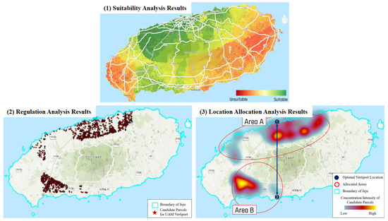
Figure 3 presents the results of the three-stage geospatial analysis framework in Jeju, including suitability analysis, regulation analysis, and location allocation analysis. In the initial stage, we compute suitability scores at a 100 m × 100 m grid resolution for Jeju, considering a variety of factors. Figure 3 illustrates the amalgamation of individual weighted scores, portraying an overall ranking ranging from “unsuitable” (depicted in red) to “suitable” (in green). The outcomes reveal distinct concentrations of higher suitability scores in specific regions, particularly in downtown areas of Jeju-si and Seogwipo-si. These regions exhibit high population density, mixed land use, and superior transportation accessibility.
Figure 3.
Results of the Three-Stage Geospatial Analysis Framework in Jeju.
During the first analytical stage, which focused on suitability analysis, we conduct additional examinations. Specifically, the outcomes of hotspot and kernel density analyses pinpoint specific grids with significantly higher suitability scores, notably compared to the western and eastern sides of Jeju. The spatial concentration of parcels with higher suitability scores is primarily due to their proximity to the international airport in Jeju and popular tourist attractions. This finding underscores the importance of accessibility to key infrastructure and destinations in determining suitable locations for UAM vertiports.
Moreover, the suitability analysis, which primarily emphasizes travel demand and population density, inherently biases against regions inhabited by marginalized population groups or rural areas. This exclusion raises critical equity concerns, as it overlooks the transportation needs and potential benefits that UAM infrastructure could provide to these underserved communities. The reliance on conventional urban-centric metrics such as high population density and substantial travel demand inadvertently marginalizes lower-density regions, reinforcing spatial inequities in access to advanced transportation technologies. Consequently, this highlights an imperative for adopting a more inclusive and equitable framework in UAM infrastructure planning. Such a framework should integrate socio-economic and demographic variables to ensure a balanced distribution of vertiport locations, thereby promoting equitable access and addressing the mobility needs of diverse population groups, including those in rural and marginalized areas.
Also, the sensitivity analysis affirms the robustness of the suitability analysis since marginal fluctuations were observed in the overall patterns and distributions of suitability scores when altering factors and weights in diverse setting within the analysis framework. We believe this stability underscores the reliability and validity of the initial suitability analysis results.
4.1.2. Regulation Analysis Result
In the second stage, the analysis delves into various regulations and laws to filter out parcels with top 10% suitability scores, ensuring the identification of only those eligible for legal UAM vertiport construction (see Figure 3). This screening results in the selection of 1442 parcels, primarily concentrated in the northern and southern regions of Jeju, from the initial pool of 878,006 parcels meeting both the suitability and regulatory criteria. Key areas include Jeju Airport vicinity, Jeju City center, Seogwipo Jungmun, Jeju International Convention Center vicinity, and specific locations in Hanlim-eup. However, the eastern and western regions of Jeju, known for their popular tourist attractions, receive lower suitability scores due to their exclusion under OLS regulations, such as flight caution areas or military operation areas. This demonstrates the critical role of regulatory compliance in the site selection process, which can significantly impact the feasibility of potential vertiport locations.
4.1.3. Location Allocation Analysis Result
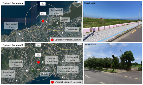
Moving to the third stage, our location allocation analysis hinges on the Jeju master plan 2040 and the concentration intensity of suitability scores. Figure 3 delineates two distinct areas identified through this process. Subsequently, by factoring in elements such as lower land prices, land vacancy, and higher potential demands, we pinpoint two optimal vertiport locations out of 1442 parcels denoted by dark red dots in Figure 3. Thus, we identified two optimal parcels (see Figure 4). These parcels are advantageous because they are not currently utilized for any purposes, which simplifies the implementation process.
Figure 4.
Optimal UAM Vertiport Locations in Jeju.
Specifically, Figure 4 presents location and street views of the two optimal locations selected in the three-stage geospatial analysis framework. Notably, Optimal Location A in Jeju commands a price of 1,286,000 won per square meter and is characterized by a demographic profile comprising 197 teenagers, 1880 working-age individuals, and 423 elderly residents. Also, Optimal Location B in Jeju is priced at 194,999 won per square meter and accommodates a population with relatively lower numbers, although it stands out as the highest among the candidate parcels in Area B. The key attributes of Optimal Location B include its strategic positioning in major tourist attraction areas in Jeju and its exceptional transport accessibility to the International Convention Center. These findings underscore the nuanced considerations involved in optimal location selection, ranging from demographic profiles and economic factors to tourism-related opportunities.
4.2. Busan
4.2.1. Suitability Analysis Result
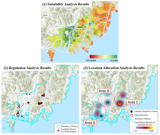
Figure 5 presents results of the three-stage geospatial analysis framework in Busan, including suitability analysis, regulation analysis, and location allocation analysis. Illustrated in Figure 5, the results of the suitability analysis for Busan indicate heightened suitability scores in grids encompassing major transportation nodes, such as areas adjacent to airports, transit stations, subway stations, and interchanges. This observation is particularly noteworthy as it aligns with the strategic objective of optimizing accessibility and connectivity—essential factors for the success of UAM services. The emphasis on higher suitability scores around major transportation nodes contributes to the adequacy of these findings in the context of urban planning and practices. However, eastern area of Busan receives lower suitability scores while marginalized population groups live in the areas. This outcome suggests potential concerns related to transportation equity, as the lowered suitability scores may imply insufficient accessibility and services for marginalized populations. Also, sensitivity analysis results serve to validate the robustness of the suitability analysis. It demonstrates the stability of suitability scores, even when subjected to alterations in factors and weights.
Figure 5.
Results of the Three-Stage Geospatial Analysis Framework in Busan.
4.2.2. Regulation Analysis Result
In the second stage, following the exclusion of parcels incompatible with UAM vertiport construction under South Korean laws and regulations, an outcome emerges for Busan, with a discerning identification of 21 viable parcels out of a total of 716,441 (see Figure 5). The identified areas include locations near Gimhae Airport, Shinho General Industrial Complex, Hwajeon Industrial Complex, Myeongji National Industrial Complex, Seomyeon Station, and Dongnae Station. However, the vicinity of the Osiria Tourism Zone is deemed unsuitable for vertiport development. This decision is grounded in the fact that the area falls within a 2.5 km (2NM) radius of restricted gas supply facilities, leading to an analysis of unsuitability based on regulatory considerations. These selected parcels exhibit a spatial concentration in three areas, as depicted in Figure 5. Notably, the categorization of these areas aligns strategically with plans for urban development and transportation system outlined in the Busan master plan. This finding holds considerable significance for urban planning and practices, offering a targeted selection of parcels in areas harmonious with established strategic urban development goals.
4.2.3. Location Allocation Analysis Result
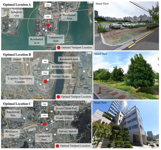
Moving to the results of the third stage, illustrated in Figure 6 are detailed insights into the three optimal vertiport locations in Busan. First and foremost, Optimal Location A strategically situates itself in close proximity to newly developed residential, commercial, and industrial zones, forming a vital connection to an interchange and a well-established public transportation network. The UAM vertiport at this location holds the potential to serve a significant population, encompassing 3882 teenagers, 12,962 individuals of working age, and 1851 elderly within a convenient walking distance of 500 m. Moving to Optimal Location B, it occupies a crucial position within important transportation networks by linking seamlessly with the airport, subway, and bus systems. Additionally, its adjacency to a logistics distribution complex and residential areas further enhances its strategic significance. Notably, the land price for this parcel stands at 1,324,000 won per square meter, marking it as the most economically viable option among the considered parcels in this area.
Figure 6.
Optimal UAM Vertiport Locations in Busan.
Lastly, Figure 5 provides a visual representation and street view of Optimal Location C, emphasizing its well-connected nature to transit, subway, and bus systems in Busan. Covering a substantial population of 62,556 individuals within a one-kilometer radius, this location is positioned for significant impact. Notably, the vertiport at Optimal Location C is slated for development atop the Busan Jiin-gu office, which is being used as a heliport. This arrangement not only presents minimal developmental challenges but also aligns with the broader goals outlined in the 2030 Mobility Plan by the Ministry of Land, Infrastructure, and Transport in South Korea. While rooftop vertiports may have throughput limitations compared to ground-level installations, their deployment addresses the necessity to optimize limited urban space in densely populated areas. Despite these limitations, rooftop vertiports offer unique advantages, including reduced need for extensive ground infrastructure and mitigation of noise pollution and visual impact. Moreover, within the broader context of a multimodal transportation ecosystem, rooftop vertiports complement existing ground-based systems, enhancing overall accessibility and mobility within urban areas.
5. Discussion
5.1. Policy and Planning Implicatios
5.1.1. Strategic Integration of UAM in Transportation Systems
The optimal location selection of UAM vertiports in Busan offers several noteworthy insights for transportation and land use planning. First, the strategic alignment of vertiport siting with newly developed residential, commercial, and industrial zones is consistent with the principles of Transit-Oriented Development (TOD). This integration not only facilitates efficient UAM infrastructure deployment but also contributes to the creation of vibrant, sustainable, and accessible urban environments. These findings are consistent with Jacobson and Forsyth [33], who emphasized the role of TOD in enhancing urban accessibility and reducing dependence on private vehicles.
Furthermore, prioritizing connectivity with major transportation nodes—such as highway interchanges, airports, and transit stations—reflects an accessibility-based planning paradigm. Enhancing intermodal connectivity through vertiport siting improves overall transportation network cohesion, particularly in addressing spatial disparities in accessibility [34]. This strategy aligns with the work of Cervero and Kockelman [35], who demonstrated that well-connected urban systems are more resilient, sustainable, and efficient. Selecting vertiport locations co-located with existing transport systems underscores the potential for seamless intermodal transitions.
5.1.2. Addressing Equity in Advanced Air Mobility Infrastructure
The observed lower suitability scores in areas with marginalized populations, such as parts of Busan and Jeju, raise significant concerns regarding transportation equity. This outcome underscores the risk of reinforcing existing spatial inequalities if UAM planning relies solely on metrics such as population density or commercial activity. El-Geneidy et al. [36] stress the importance of inclusive accessibility in transport frameworks, calling for deliberate efforts to prevent the marginalization of underrepresented communities [37]. While UAM services may involve higher initial costs compared to conventional modes, they also offer substantial benefits—such as reduced travel times and improved access in areas with limited ground infrastructure [4,5,6,7]. These benefits are especially pertinent for populations residing in geographically or “infrastructurally” disadvantaged regions. Hence, equity considerations should extend beyond cost analysis to encompass broader accessibility goals [38], ensuring that all demographic groups can benefit from UAM services.
5.2. Methodological Reflections and Comparative Evaluation
5.2.1. Contributions to Geospatial Decision-Making for UAM
The methodology adopted in this study—comprising suitability analysis, regulation analysis, and location allocation analysis—offers a comprehensive and replicable framework for UAM vertiport location planning. Informed by literature on optimal location selection in transportation infrastructure [21,22], this approach systematically incorporates both spatial and regulatory dimensions into the decision-making process. Previous studies, such as Das [23], employed multi-objective modeling to address complex logistical goals involving cost, customer satisfaction, and environmental sustainability. The present framework contributes to this evolving methodological landscape by focusing on UAM-specific challenges. It addresses regulatory compliance, urban form integration, and area-specific characteristics, thereby filling gaps in prior UAM suitability models [12,39]. This systematic methodology equips urban planners and policymakers with a structured, evidence-based approach to site selection that remains sensitive to real-world regulatory and spatial constraints.
5.2.2. Comparative Evaluation of the Three-Stage Geospatial Analysis Framework
Although the three-stage geospatial framework is not a formal multi-objective optimization model, it offers distinct advantages in regulatory and land-use planning contexts. Unlike more abstract optimization approaches, the framework emphasizes legal compliance, spatial compatibility, and practical deployment—factors often overlooked in purely mathematical models. Its value lies in its real-world applicability. As demonstrated in Table 5, practitioners can employ the framework to align vertiport placement with regional land use characteristics and urban planning priorities. Furthermore, the regulation analysis component enables the exclusion of parcels that do not meet policy criteria, thereby minimizing implementation barriers. In summary, the framework’s strength lies in its systematic treatment of spatial, legal, and strategic considerations, enhancing the feasibility and sustainability of UAM infrastructure integration within evolving urban landscapes.
Table 5.
Descriptions of the Three-Stage Geospatial Analysis Framework.
5.3. Limitations and Future Research Directions
5.3.1. Limitations of This Study
Despite its contributions, this study is not without limitations. First, the analysis is based on static spatial data and may not fully capture dynamic urban changes or technological advances. Second, stakeholder perspectives were not directly incorporated, which may limit the framework’s responsiveness to community concerns and user needs. Third, findings may not be universally generalizable beyond the South Korean context without regional adaptation. Moreover, assumptions embedded in the suitability analysis, such as prioritization of high-density areas, may overlook other relevant variables, including tourism potential or land value fluctuations. Finally, while transportation equity concerns were acknowledged, the study does not exhaustively assess the socioeconomic impacts of UAM adoption on vulnerable populations.
5.3.2. Directions for Future Research
Future research should prioritize integrating stakeholder engagement mechanisms, such as participatory mapping, surveys, and public consultations, to enhance the inclusiveness and social legitimacy of the framework. Further development of a dynamic platform—capable of responding to real-time regulatory and environmental updates—will increase the planning tool’s robustness and policy alignment. Also, validation of the framework in diverse geographic and regulatory contexts is also essential to ensure its generalizability. Moreover, future studies should incorporate a more detailed analysis of affordability, accessibility, and other equity dimensions, especially for marginalized groups. These efforts will help advance a flexible, comprehensive, and socially responsible UAM planning paradigm that is adaptable to evolving urban mobility challenges.
6. Conclusions
This study develops a three-stage geospatial analysis framework for the optimal siting of UAM vertiports in complex urban environments, with a focus on the cities of Busan and Jeju. The findings reveal that highly suitable vertiport locations exhibit strong alignment with TOD principles, reinforcing the necessity of integrating UAM infrastructure with existing transportation networks. However, the results also raise critical concerns regarding transportation equity, as areas with marginalized populations tend to be deprioritized in the location selection process. The integration of UAM infrastructure with broader urban development agendas supports not only sustainable and resilient city growth but also the evolution of efficient, multimodal mobility systems. By establishing a robust empirical foundation, this study offers (1) practical value by aligning the proposed methodological framework with ongoing UAM pilot initiatives in South Korea, and (2) guidance for policymakers, regulatory agencies, and private-sector stakeholders to facilitate the equitable and sustainable integration of UAM within the urban fabric.
Author Contributions
Conceptualization, S.L. and N.C.; methodology, S.L. and N.C.; software, S.L. and N.C.; validation, S.L. and N.C.; formal analysis, S.L. and N.C.; investigation, S.L. and N.C.; writing—original draft preparation, S.L.; writing—review and editing, N.C.; visualization, S.L.; supervision, N.C. All authors have read and agreed to the published version of the manuscript.
Funding
This research was funded by Korea Land and Geospatial Informatix Corporation (LX), under grant number [2023-13].
Institutional Review Board Statement
Not applicable.
Informed Consent Statement
Not applicable.
Data Availability Statement
The datasets generated during and/or analyzed during the current study are available from the corresponding author on reasonable request.
Conflicts of Interest
The authors declare no conflicts of interest.
References
- Cokorilo, O. Urban Air Mobility: Safety Challenges. Transp. Res. Procedia 2020, 45, 21–29. [Google Scholar] [CrossRef]
- Cohen, A.P.; Shaheen, S.A.; Farrar, E.M. Urban Air Mobility: History, Ecosystem, Market Potential, and Challenges. IEEE Trans. Intell. Transp. Syst. 2021, 22, 6074–6087. [Google Scholar] [CrossRef]
- Garrow, L.A.; German, B.J.; Leonard, C.E. Urban Air Mobility: A Comprehensive Review and Comparative Analysis with Autonomous and Electric Ground Transportation for Informing Future Research. Transp. Res. Part C Emerg. Technol. 2021, 132, 103377. [Google Scholar] [CrossRef]
- Al Haddad, C.; Chaniotakis, E.; Straubinger, A.; Plötner, K.; Antoniou, C. Factors Affecting the Adoption and Use of Urban Air Mobility. Transp. Res. Part A Policy Pract. 2020, 132, 696–712. [Google Scholar] [CrossRef]
- Bauranov, A.; Rakas, J. Designing Airspace for Urban Air Mobility: A Review of Concepts and Approaches. Prog. Aerosp. Sci. 2021, 125, 100726. [Google Scholar] [CrossRef]
- Song, K. Optimal Vertiport Airspace and Approach Control Strategy for Urban Air Mobility (UAM). Sustainability 2023, 15, 437. [Google Scholar] [CrossRef]
- Biehle, T. Social Sustainable Urban Air Mobility in Europe. Sustainability 2022, 14, 9312. [Google Scholar] [CrossRef]
- Kellermann, R.; Biehle, T.; Fischer, L. Drones for Parcel and Passenger Transportation: A Literature Review. Transp. Res. Interdiscip. Perspect. 2020, 4, 100088. [Google Scholar] [CrossRef]
- Maheshwari, T.; Axhausen, K.W. How Will the Technological Shift in Transportation Impact Cities? A Review of Quantitative Studies on the Impacts of New Transportation Technologies. Sustainability 2021, 13, 3013. [Google Scholar] [CrossRef]
- Schweiger, K.; Preis, L. Urban Air Mobility: Systematic Review of Scientific Publications and Regulations for Vertiport Design and Operations. Drones 2022, 6, 179. [Google Scholar] [CrossRef]
- Straubinger, A.; Rothfeld, R.; Shamiyeh, M.; Büchter, K.-D.; Kaiser, J.; Plötner, K.O. An Overview of Current Research and Developments in Urban Air Mobility—Setting the Scene for UAM Introduction. J. Air Transp. Manag. 2020, 87, 101852. [Google Scholar] [CrossRef]
- Jeong, J.; So, M.; Hwang, H.-Y. Selection of Vertiports Using K-Means Algorithm and Noise Analyses for Urban Air Mobility (UAM) in the Seoul Metropolitan Area. Appl. Sci. 2021, 11, 5729. [Google Scholar] [CrossRef]
- Jung, M.; Yu, K.; Yoon, M. UAM Veriport Site Selection Criteria and Importance Analysis Based on ANP Model. Aviat. Manag. Soc. Korea 2021, 19, 3–19. [Google Scholar] [CrossRef]
- Malczewski, J.; Rinner, C. Multicriteria Decision Analysis in Geographic Information Science, 2015th ed.; Springer: Berlin/Heidelberg, Germany, 2015. [Google Scholar]
- Khahro, S.H.; Matori, A.N.; Chandio, I.A.; Talpur, M.A.H. Data Preparation for GIS Based Land Suitability Modelling: A Stepped Approach. E3S Web Conf. 2019, 101, 02001. [Google Scholar] [CrossRef]
- Mishra, S.; Sahu, P.K.; Sarkar, A.K.; Mehran, B.; Sharma, S. Geo-Spatial Site Suitability Analysis for Development of Health Care Units in Rural India: Effects on Habitation Accessibility, Facility Utilization and Zonal Equity in Facility Distribution. J. Transp. Geogr. 2019, 78, 135–149. [Google Scholar] [CrossRef]
- Özkan, B.; Özceylan, E.; Sarıçiçek, İ. GIS-Based MCDM Modeling for Landfill Site Suitability Analysis: A Comprehensive Review of the Literature. Environ. Sci. Pollut. Res. 2019, 26, 30711–30730. [Google Scholar] [CrossRef]
- Younes, A.; Kotb, K.M.; Abu Ghazala, M.O.; Elkadeem, M.R. Spatial Suitability Analysis for Site Selection of Refugee Camps Using Hybrid GIS and Fuzzy AHP Approach: The Case of Kenya. Int. J. Disaster Risk Reduct. 2022, 77, 103062. [Google Scholar] [CrossRef]
- Topuz, M.; Deniz, M. Application of GIS and AHP for Land Use Suitability Analysis: Case of Demirci District (Turkey). Humanit. Soc. Sci. Commun. 2023, 10, 115. [Google Scholar] [CrossRef]
- Elboshy, B.; Alwetaishi, M.; Aly, R.M.H.; Zalhaf, A.S. A Suitability Mapping for the PV Solar Farms in Egypt Based on GIS-AHP to Optimize Multi-Criteria Feasibility. Ain Shams Eng. J. 2022, 13, 101618. [Google Scholar] [CrossRef]
- Shui, C.S.; Szeto, W.Y. A Review of Bicycle-Sharing Service Planning Problems. Transp. Res. Part C Emerg. Technol. 2020, 117, 102648. [Google Scholar] [CrossRef]
- Ahmad, F.; Iqbal, A.; Ashraf, I.; Marzband, M.; Khan, I. Optimal Location of Electric Vehicle Charging Station and Its Impact on Distribution Network: A Review. Energy Rep. 2022, 8, 2314–2333. [Google Scholar] [CrossRef]
- Das, S.K.; Yu, V.F.; Roy, S.K.; Weber, G.W. Location–Allocation Problem for Green Efficient Two-Stage Vehicle-Based Logistics System: A Type-2 Neutrosophic Multi-Objective Modeling Approach. Expert Syst. Appl. 2024, 238, 122174. [Google Scholar] [CrossRef]
- Mendonca, N.; Murphy, J.; Patterson, M.D.; Alexander, R.; Juarex, G.; Harper, C. Advanced Air Mobility Vertiport Considerations: A List and Overview. In Proceedings of the AIAA AVIATION 2022 Forum, Chicago, IL, USA, 27 June–1 July 2022; AIAA AVIATION Forum. American Institute of Aeronautics and Astronautics: Reston, VA, USA, 2022. [Google Scholar]
- Kim, W.; Park, J.; Yu, J.W.; Ko, J. A Study on the Criterions Affecting UAM Vertiport Location Based on User-Oriented Perspectives. JKST 2023, 41, 212–225. [Google Scholar] [CrossRef]
- Fadhil, D.N. A GIS-Based Analysis for Selecting Ground Infrastructure Locations for Urban Air Mobility; Technical University of Munich: München, Germany, 2018. [Google Scholar]
- Villa, A. Hub Location Problem for Optimal Vertiport Selection in Urban Air Mobility-Chicago Case Study; University of Illinois Chicago: Chicago, IL, USA, 2022. [Google Scholar]
- Baldwin, M.; Fox, A.; Klondike, T.; Hovis, M.; Shear, T.; Joca, L.; Hester, M.; Cubbage, F. Geospatial Analysis and Land Suitability for “FloodWise” Practices: Nature-Based Solutions for Flood Mitigation in Eastern, Rural North Carolina. Land 2022, 11, 1504. [Google Scholar] [CrossRef]
- European Union Aviation Safety Agency. Study on Societal Acceptance of Urban Air Mobility in Europe; EASA: Cologne, Germany, 2021.
- European Union Aviation Safety Agency. Prototype Technical Specifications for the Design of VFR Vertiports for Operation with Manned VTOL-Capable Aircraft Certified in the Enhanced Category; EASA: Cologne, Germany, 2022.
- Ministry of Land, Infrastructure and Transport. Mobility Innovation Roadmap; Ministry of Land, Infrastructure and Transport: Sejong, Republic of Korea, 2022.
- UAM Team Korea. K-UAM Concept of Operations 1.0; Ministry of Land, Infrastructure and Transport: Sejong, Republic of Korea, 2021.
- Jacobson, J.; Forsyth, A. Seven American TODs: Good Practices for Urban Design in Transit-Oriented Development Projects. J. Transp. Land Use 2008, 1, 51–88. [Google Scholar] [CrossRef]
- Israel, E.; Frenkel, A. Social Justice and Spatial Inequality: Toward a Conceptual Framework. Prog. Hum. Geogr. 2017, 42, 030913251770296. [Google Scholar] [CrossRef]
- Cervero, R.; Kockelman, K. Travel Demand and the 3Ds: Density, Diversity, and Design. Transp. Res. Part D Transp. Environ. 1997, 2, 199–219. [Google Scholar] [CrossRef]
- El-Geneidy, A.; Levinson, D.; Diab, E.; Boisjoly, G.; Verbich, D.; Loong, C. The Cost of Equity: Assessing Transit Accessibility and Social Disparity Using Total Travel Cost. Transp. Res. Part A Policy Pract. 2016, 91, 302–316. [Google Scholar] [CrossRef]
- Golub, A.; Brown, A.; Brakewood, C.; MacArthur, J.; Lee, S.; Ziedan, A. Equity and Exclusion Issues in Cashless Fare Payment Systems for Public Transportation. Transp. Res. Interdiscip. Perspect. 2022, 15, 100628. [Google Scholar] [CrossRef]
- Lee, S.; Im, J.; Cho, K. Understanding Spatial Inequalities and Stratification in Transportation Accessibility to Social Infrastructures in South Korea: Multi-Dimensional Planning Insights. Sci. Rep. 2024, 14, 18445. [Google Scholar] [CrossRef]
- Oh, J.-S.; Hwang, H.-Y. Selection of Vertiport Location, Route Setting and Operating Time Analysis of Urban Air Mobility in Metropolitan Area. J. Adv. Navig. Technol. 2020, 24, 358–367. [Google Scholar] [CrossRef]
Disclaimer/Publisher’s Note: The statements, opinions and data contained in all publications are solely those of the individual author(s) and contributor(s) and not of MDPI and/or the editor(s). MDPI and/or the editor(s) disclaim responsibility for any injury to people or property resulting from any ideas, methods, instructions or products referred to in the content. |
© 2025 by the authors. Licensee MDPI, Basel, Switzerland. This article is an open access article distributed under the terms and conditions of the Creative Commons Attribution (CC BY) license (https://creativecommons.org/licenses/by/4.0/).