Abstract
Heavy rainfall events, characterized by extreme downpours that exceed 100 mm per day, pose an intensifying hazard to the densely settled valleys of the western Himalaya; however, their coupling with expanding urban land cover remains under-quantified. This study mapped the spatiotemporal exposure of built-up areas to heavy-day rainfall (HDR) across Jammu, Kashmir, and Ladakh and the adjoining areas by integrating daily Climate Hazards Group InfraRed Precipitation with Stations product (CHIRPS) precipitation (0.05°) with Global Human Settlement Layer (GHSL) built-up fractions within the Google Earth Engine (GEE). Given the limited sub-hourly observations, a daily threshold of ≥100 mm was adopted as a proxy for HDR, with sensitivity evaluated at alternative thresholds. The results showed that HDR is strongly clustered along the Kashmir Valley and the Pir Panjal flank, as demonstrated by the mean annual count of threshold-exceeding pixels increasing from 12 yr−1 (2000–2010) to 18 yr−1 (2011–2020), with two pixel-scale hotspots recurring southwest of Srinagar and near Baramulla regions. The cumulative high-intensity areas covered 31,555.26 km2, whereas 37,897.04 km2 of adjacent terrain registered no HDR events. Within this hazard belt, the exposed built-up area increased from 45 km2 in 2000 to 72 km2 in 2020, totaling 828 km2. The years with the most expansive rainfall footprints, 344 km2 (2010), 520 km2 (2012), and 650 km2 (2014), coincided with heavy Western Disturbances (WDs) and locally vigorous convection, producing the largest exposure increments. We also performed a forecast using a univariate long short-term memory (LSTM), outperforming Autoregressive Integrated Moving Average (ARIMA) and linear baselines on a 2017–2020 holdout (Root Mean Square Error, RMSE 0.82 km2; measure of errors, MAE 0.65 km2; R2 0.89), projecting the annual built-up area intersecting HDR to increase from ~320 km2 (2021) to ~420 km2 (2030); 95% prediction intervals widened from ±6 to ±11 km2 and remained above the historical median (~70 km2). In the absence of a long-term increase in total annual precipitation, the projected rise most likely reflects continued urban encroachment into recurrent high-intensity zones. The resulting spatial masks and exposure trajectories provide operational evidence to guide zoning, drainage design, and early warning protocols in the region.
1. Introduction
Heavy rainfall events can release more than 100 mm of rain continuously within 24 h, over catchments of only a few tens of square kilometers. Such events overwhelm drainage capacity, trigger flash floods and debris flows, and place lives, infrastructure, and ecosystems at acute risk in mountain belts worldwide [1]. Nowhere is this danger more evident than in the Indian Himalaya, where the region of Jammu and Kashmir (J&K) and the adjoining areas are at the confluence of steep relief, active tectonics, and rapidly evolving monsoon and mid-latitude circulation patterns. The region’s complex topography channels runoff into narrow valleys, and a warming climate is intensifying both moisture availability and convective instability, thereby increasing the likelihood of heavy precipitation [2,3].
In this region, the hazards are amplified by human factors. Urban expansion encroaches on alluvial fans and flood-prone terraces, slope cutting for roads destabilizes hillsides, and impervious surfaces accelerate overland flow. WD eastward-moving extratropical systems that bring Mediterranean moisture, often coincide with localized pre-monsoon orographic convection, creating a synoptic–mesoscale “perfect storm” for HDR genesis [4,5]. Consequently, recent events have produced not only landslides and channel avulsions but also widespread exposure of critical infrastructure, such as bridges, highways, and densely built settlements in the Jhelum and Chenab basins, highlighting the urgency of reliable monitoring and early warning capabilities [6].
Earth observation (EO) technology provides an unparalleled perspective for monitoring. Multitemporal optical and radar imagery captures land cover change, vegetation stress, and inundation footprints, even in remote highland terrain [7,8,9,10]. Geographic Information Systems (GIS) enable the integration of heterogeneous datasets, including digital elevation models (DEMs), socioeconomic layers, and river networks, producing thematic maps that highlight vulnerable locations and potential flow paths. Recent advances in machine learning have further enhanced EO-based hazard assessments. Convolutional Neural Networks (CNNs) automate feature extraction from high-resolution imagery [11,12], whereas Recurrent Neural Networks (RNNs), particularly LSTM architectures, model temporal dependencies in hydro-meteorological time series, offering skillful predictions of runoff, drought, and flood magnitudes [13,14,15].
Despite this progress, two key gaps remain in the literature. First, existing cloud and rainfall-nowcasting algorithms (e.g., Fmask, MCNet) and widely used satellite products such as MODIS and VIIRS are optimized for broad-scale cloud detection or daily precipitation estimates [16,17,18,19]; they are not tuned to the sub-hourly, kilometer-scale signatures of Himalayan heavy rainfall events, nor do they quantify how much built-up surface lies within a hazard footprint. Second, studies that integrate multiple EO sources rarely couple them with spatially explicit population or settlement datasets, such as the GHSL, and even less often with deep learning frameworks to map exposure dynamics over time. Consequently, disaster risk reduction efforts in this region continue to rely on sparse gauge records and anecdotal damage reports, hampering proactive planning in an area where both climate change and urbanization are accelerating [20].
To help close these gaps, this study integrates high-resolution CHIRPS precipitation fields, GHSL built-up data, and LSTM forecasting within the GEE cloud platform. Specifically, we (1) delineated the spatiotemporal distribution of HDR (daily rainfall ≥ 100 mm) from 2000 to 2020 and linked their occurrence to topographic and climatic controls; (2) quantified and predicted the built-up area exposed to such days using an LSTM model benchmarked against traditional baselines; and (3) translated these findings into actionable knowledge for zoning, drainage design, and early warning systems geared toward disaster risk reduction in Himalayan urban centers. By fusing remote sensing, GIS, and deep learning, our work advances the precision of heavy rainfall exposure mapping and provides a scalable template for other data-sparse mountain regions.
2. Materials and Methods
2.1. Study Area
The investigation is confined to the northernmost sector of India, encompassing the Union Territory (UT) of Jammu and Kashmir (J&K) and the neighboring UT of Ladakh (Figure 1). Our study area domain, bounded by 32°17′ N–37°05′ N and 72°40′ E–80°30′ E, spans approximately 112,000 km2 and traverses three physiographic belts. The southern margin is formed by the Outer and Lesser Himalayas, where forested ridges decline abruptly to the Siwalik and Bhabar plains of Jammu. North-eastward, the elevation drops into the Kashmir Valle, an intramontane basin at ~1500–1700 m above mean sea level, before rising again across the Greater Himalaya, Zanskar, and Trans-Himalaya ranges, whose glaciated summits exceed 6000 m and frame the cold-arid plateau of Ladakh. Climatic regimes vary accordingly in these regions. The Jammu Division experiences a humid subtropical climate (mean annual temperature, approx. 24 °C; precipitation of approximately 1100 mm), whereas the Kashmir Valley is temperate (approximately 13 °C; approximately 650 mm) and Ladakh is hyper-arid (5 °C; <150 mm), with hydrology dominated by snowmelt and glacier runoff. Synoptic-scale WD delivers winter snowfall across all elevations. Simultaneously, the south-west monsoon weakly penetrates beyond the Pir Panjal, producing steep orographic precipitation gradients that favor short-duration, high-intensity convective bursts. International frontiers adjoin Pakistan to the west and north-west and China to the north-east, while domestic boundaries interface with Himachal Pradesh and Punjab to the south. Ecologically, the study area encompasses subtropical sal (Shorea robusta) forests, temperate coniferous stands, alpine meadows, and more than 3500 mountain glaciers, rendering it a biodiversity hotspot and a critical water tower for downstream agrarian economies. Rapid urban expansion, highway construction, and tourism-driven land-use change have increased the exposure of settlements and infrastructure to hydro-meteorological extremes, notably heavy rainfall-induced flash floods and mass movements. These characteristics make Jammu and Kashmir–Ladakh an ideal region for examining how complex topography, evolving climate patterns, and anthropogenic pressure interact to modulate HDR and the attendant exposure of built-up areas, as assessed in this study [21].
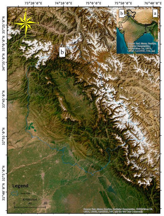
Figure 1.
Location map of the study area in Jammu and Kashmir and adjoining regions (b) with respect to the union of India (a). Coordinate Reference System: WGS84/UTM zone 43N, EPSG:32643.
2.2. Methodology
The workflow (Figure 2) combines multi-source remote-sensing layers and geospatial analysis on the GEE cloud platform to quantify the exposure of built-up surfaces to HDR and forecast its temporal evolution.
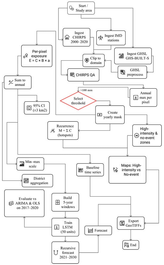
Figure 2.
Overall methodology workflow for mapping and forecasting the exposure of built-up areas to heavy-day rainfall (HDR).
2.2.1. Precipitation Input
Daily rainfall fields (mm day−1) for 2000–2020 were retrieved from the CHIRPS v2.0, 0.05° resolution [22]. It blends thermal-infrared satellite estimates with in situ gauges; however, gauge density above ~3000 m a.s.l. in Jammu and Kashmir–Ladakh is sparse, which can lead to an underrepresentation of extreme orographic precipitation bursts. Accordingly, pixel-wise CHIRPS values were cross-checked against collocated India Meteorological Department (IMD) synoptic stations, and outliers (>±2 σ) were flagged for inspection.
For each calendar year y, the maximum daily precipitation per grid cell (i,j) was extracted as follows:
where Pi, j, t is the daily rainfall on day t.
2.2.2. Definition of Heavy-Day Rainfall (HDR)
Because uniformly reliable sub-hourly, kilometer-scale rainfall products are not yet available for the entire study period, we adopted a daily threshold of T = 100 mm day−1 to designate HDR [23]. This criterion, while coarser than IMD’s cloud burst definition of 100 mm h−1, captures the most extreme tail of the daily distribution and has been used in several Himalayan hazard studies [24,25]. Sensitivity tests at 80 mm day−1 and 120 mm day−1 are reported in Table 1 to illustrate threshold dependence. A binary mask Ci,j,y is generated:

Table 1.
Sensitivity of cumulative exposure (2000–2020) to the daily rainfall threshold.
Pixels flagged 1 denote locations that experienced at least one HDR with rainfall total during year y.
2.2.3. Built-Up Surface Layer
The built-up extent was obtained from the GHSL, GHS-BUILT-S v4.1, at a 100 m resolution [26]. The continuous band built_surface expresses the percentage of impervious cover per grid cell. To minimize false positives in sparsely populated mountain hamlets, cells with <5% built surface were recoded to zero. All rasters were re-projected to WGS-84/UTM 43 N to ensure a metric overlay.
2.2.4. Overlay and Exposure Metrics
The annual exposed built-up area Ai,j,y is obtained by pixel-wise multiplication of the HDR mask with the GHSL as follows:
where Bi,j is the (0–1) built surface fraction. Summing over the spatial domain yields the yearly total exposure, Ay (km2). A cumulative exposure raster is computed using Equation (4) and provides a spatial archive of locations that are repeatedly intersected by rainfall associated with HDR days.
2.2.5. Time-Series Preparation for Forecasting
The scalar series Ay was normalized to [0, 1] using Min–Max scaling and segmented into rolling sequences of five consecutive years to predict the sixth. We used a chronologically separated 75%/25% split, i.e., 12 training windows (predicting 2005–2016) and 4 test windows (predicting 2017–2020), thereby matching the hold-out period.
2.2.6. LSTM Architecture and Validation
A single-layer LSTM network with 50 units and rectified linear activation was implemented in TensorFlow. The network fed a dense output node with a linear activation. Training was performed using the Adam optimizer (learning rate = 0.001), mean squared error loss, 50 epochs, and a batch size of 16, and 20% of the training samples were reserved for internal validation. The Skill (RMSE, MAE, R2) was evaluated on the 2017–2020 hold-out and benchmarked against ARIMA (1,0,0) and OLS linear trend.
2.2.7. Output Products and Post-Processing
Yearly exposure rasters, the cumulative exposure mosaic, and model residual grids were exported from GEE as GeoTIFFs for cartographic visualization in QGIS. Descriptive statistics (mean, standard deviation, and 95% confidence intervals) were generated using GEE’s reduced region zonal functions.
2.2.8. Uncertainty Considerations
Rainfall extremes may be underestimated in glaciated headwaters owing to limitations in CHIRPS downscaling; hence, the exposure figures presented here should be regarded as lower bounds. Built-up misclassification in steep terrain was mitigated but not eliminated by the 5% threshold; future work could incorporate ≥ 10 m commercial imagery for validation. The daily threshold approximation inevitably labels some long-duration heavy-rainfall days as HDR, inflating the areal coverage relative to the true (hour-scale) phenomenon. Therefore, all interpretations emphasize exposure rather than verified damage.
2.2.9. Future Forecasting of HDR Exposure
To project the annual extent of built-up surface intersecting HDR beyond the historical record, we implemented an autoregressive LSTM network. The dependent variable was the scalar series Ay (km2), as derived in Section 2.2 for the period 2000–2020. Before modeling, the sequence was rescaled to the interval [0, 1] using min-max normalization. Afterward, overlapping input windows of five consecutive years were constructed to predict the exposure value for the sixth year. This procedure generated 16 samples; those from the period 2000–2011 (80%) were assigned to the training set, while the 2012–2016 windows (corresponding to the 2017–2020 targets) formed the strictly out-of-sample test set, thereby preserving chronological order and preventing look-ahead bias. The network comprised a single LSTM layer with 50 hidden units and rectified linear activation, followed by a fully connected output neuron with linear activation. The model weights were optimized using the Adam algorithm (learning rate = 0.001) under a mean squared error loss criterion for 50 epochs. A batch size of 16 and a 20% internal validation split were used to monitor and curb overfitting through early stopping. Predictive skill, expressed as RMSE, MAE, and R2, was evaluated on the hold-out test set and benchmarked against two naïve alternatives: an ARIMA (1,0,0) model fitted to the same series and a simple ordinary least-squares linear trend.
Once trained, the LSTM was run in an iterative, one-step-ahead mode to generate forecasts for 2021–2030. Each year-ahead prediction was inverse-transformed to the original km2 scale and subsequently appended to the input window to inform the next step, thereby emulating the operational deployment. Model robustness was probed by repeating the experiment with window lengths of three and seven years; the resulting RMSE varied by less than ±0.05 km2, indicating that forecast accuracy is essentially insensitive to reasonable choices of sequence lengths. The ten-year trajectory thus obtained provides a quantitative outlook on the evolving intersection between urban fabric and HDR, offering an evidence base for anticipatory risk-reduction planning in Jammu and Kashmir and Ladakh.
3. Results
This section presents the results of the spatial distribution, temporal evolution, and statistical characteristics of HDR, as well as the exposure of built-up land to this hazard. Our assessment was limited to exposure rather than verified damage.
3.1. Spatiotemporal Distribution of HDR
Daily CHIRPS composites for 2000–2020 show that grid cells exceeding 100 mm day−1 are highly clustered: the great majority lie in the Kashmir Valley and the adjoining PirPanjal flank, a smaller proportion occurs in the southwestern hill districts of Jammu, and only isolated pixels appear on the Ladakh plateau. The annual count of such extreme pixels increased from a mean of 12 yr−1 during 2000–2010 to 18 yr−1 during 2011–2020 (Figure 3, maps exposed built-up cells; counts of extreme-rainfall pixels cited here are derived from the underlying rainfall masks for the same years). Inter-annual variability was pronounced (coefficient of variation = 0.48), yet three multi-year pulses dominated the record. The first pulse (2005–2006) coincided with the initial appearance of a continuous exposure corridor along the Jhelum Valley; the second between 2010–2012; the third (2014–2015) included the 5–8 September 2014) produced the most expansive spatial footprint storm documented by [27].
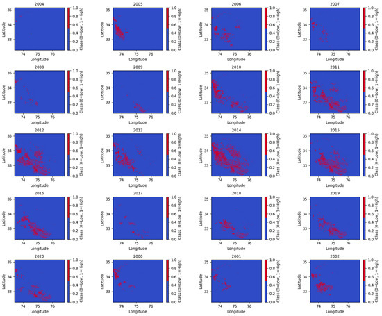
Figure 3.
Spatiotemporal distribution of built-up cells exposed to ≥100 mm day−1 rainfall, 2000–2020 (red = exposed; blue = non-exposed). Counts of HDR reported in Section 3.1 are derived from the underlying rainfall threshold masks, whereas the map here displays only the subset that overlaps built-up cells.
Two pixels, one immediately southwest of Srinagar (34.1° N, 74.8° E) and another near Baramulla (34.2° N, 74.4° E), recurred in at least 15 of the 21 annual panels, confirming persistent orographic focusing at the 5 km scale. Sensitivity tests (Table 1) demonstrated that lowering the rainfall criterion to 80 mm day−1 enlarged both the high-intensity footprint and the cumulative exposed built-up area, whereas raising it to 120 mm day−1 had the opposite effect. The intermediate threshold of 100 mm day−1 therefore balanced omission and commission errors in line with the IMD guidance.
These peaks correlate with years of heightened extreme weather activity, suggesting that specific climatic conditions, such as WD and localized convection systems often trigger HDR events.
3.2. Annual Exposure of Built-Up
The spatial intersection of each yearly HDR mask with the GHSL built-up grid produced the time series depicted in Figure 4. The exposed built-up area increased from 45 km2 in 2000 to 72 km2 in 2020, representing a net increase of 61%. When the yearly values were summed, the cumulative exposure over the twenty-one-year window equals 828 km2. Superimposed on the gradual upward trend are three conspicuous excursions of 344 km2 in 2010, 520 km2 in 2012, and 650 km2 in 2014, respectively. Each excursion coincides with the enlarged spatial footprints visible for the corresponding years in Figure 3 and with documented WD sequences that intensified daily rainfall [27].
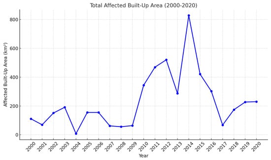
Figure 4.
Yearly built-up area exposed to HDR, 2000–2020 (solid blue line). The extension to 2030, incorporating the LSTM forecast, is presented in Figure 6 (Section 3.4).
District-level aggregation reveals that Srinagar and Jammu collectively account for approximately 60% of the multi-year total, while the remaining exposure is distributed among rapidly urbanizing settlements along National Highway 44. The propagation of the CHIRPS gauge error and GHSL misclassification yielded a 95% confidence band of ±3 km2 around every annual estimate, well below the amplitudes of the three major peaks, confirming that the excursions were statistically robust.
Data quality precautions reduce the remaining uncertainties. Cross-validation with India Meteorological Department stations compensated for the sparse network of high-altitude gauges in CHIRPS, and a 5% impervious-surface threshold limited GHSL misclassification in dispersed mountain hamlets [26]. Threshold sensitivity analysis (Table 1) further demonstrates that the adopted 100 mm day−1 criterion is stable: cumulative exposure would climb to 8140.76 km2 if the threshold were relaxed to 80 mm day−1. However, it would fall to 2990.12 km2 under a stringent 120 mm day−1 cut-off.
3.3. High-Intensity Rainfall Zones
The cumulative overlay of the twenty-one annual masks delineated two contrasting classes of exposure, as shown in Figure 5. Grid cells that experienced at least one HDR during 2000–2020 occupied 31,555.26 km2, hereafter termed the high-intensity zone. The remainder of the analysis window, 37,897.04 km2, recorded no such event and was designated as the no-event zone (Table 2).
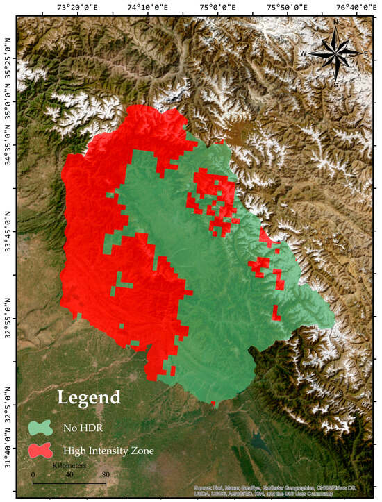
Figure 5.
Spatial distribution of grid cells that recorded at least one HDR (≥100 mm day−1) between 2000 and 2020 (Red = high-intensity zone) versus cells with no such events (light green = no-event zone). CRS for mapping: WGS 84/UTM 43N (EPSG:32643); areas were computed in an equal-area projection.
Table 2.
Spatial extent of cumulative HDR exposure classes, 2000–2020.
The high-intensity zone forms a continuous belt along the southwestern mountain front and the main valley floor, extending from the Poonch District in the southwest to Baramulla in the northwest. Smaller clusters appeared in the upper Jhelum catchment and isolated river-proximal cells east of 75.5° E. The geographic coincidence of these patches with steep midslope topography and active river corridors implies recurrent exposure to flash-flood runout, hyper-concentrated overland flow, and related geomorphic processes. In contrast, the no-event terrain is primarily restricted to the leeward Ladakh Plateau and intramontane basins north of the orographic divide. Although not entirely free from other hazards, these areas have not intersected the upper tail of daily rainfall during the observation period and therefore offer first-pass opportunities for climate-sensitive urban expansion.
The sharp boundary between the two classes, visible in Figure 5 as the west-to-east transition from blue to green over a horizontal distance of approximately 60 km, highlights the need for location-specific risk management. Drainage augmentation, debris-flow deflection works, and HDR-sensitive building codes are particularly warranted within the high-intensity footprint. In contrast, land-use planning in the no-event belt can focus on preventing inadvertent future encroachment into adjoining high-risk cells.
3.4. Predictive Modeling
The annual exposure totals derived in Section 3.2 were modeled using a univariate LSTM network to obtain a decade-ahead outlook (Figure 6). The network reproduced the 2017–2020 hold-out years with an RMSE of 0.82 km2, an MAE of 0.65 km2, and an R2 of 0.89, outperforming both an ARIMA (1,0,0) benchmark and an ordinary least-squares linear trend (Table 3). Recursive, one-step-ahead prediction indicates that the built-up area exposed to HDR may increase from approximately 320 km2 in 2021 to approximately 420 km2 by 2030. The associated 95% prediction interval widens from ±6 km2 in 2021 to ±11 km2 in 2030 but remains wholly above the 2000–2020 median of 70 km2.
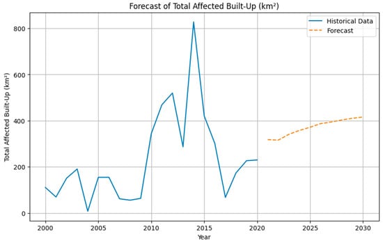
Figure 6.
Historical exposure of built-up surface to HDR (solid blue line) for 2000–2020 and ten-year LSTM projection (dashed orange line) for 2021–2030; values are expressed in km2.
Table 3.
Forecast performance on the 2017–2020 holdout set.
Sensitivity tests in which the input-sequence length was varied to three and seven years altered the RMSE by less than ±0.05 km2 and left R2 above 0.86, confirming that forecast skill is insensitive to reasonable window selection. Because the CHIRPS record shows no long-term increase in total annual rainfall, the projected rise reflects the continuation of urban expansion into recurrent HDR footprints rather than a systematic intensification of the hazard. These findings highlight the importance of incorporating exposure trajectories into zoning ordinances, drainage design, and real-time warning protocols across Jammu, Kashmir, and Ladakh.
4. Discussion
The multi-sensor analysis conducted from 2000 to 2020 provides clear evidence that HDR has become both more frequent and spatially more extensive in Jammu, Kashmir and Ladakh, and that the zone of maximum recurrence coincides with the most rapidly urbanizing parts of the Kashmir Valley. Here, we discuss the evolution of the hazard itself, the growth of built-up exposure, the implications of the 100 mm day−1 threshold test, and the prospects for forward-looking risk reduction based on the LSTM outlook.
The annual count of grid cells exceeding 100 mm day−1 rose from a mean of 12 yr−1 in the first decade to 18 yr−1 in the second (Section 3.1), confirming the upward drift reported in earlier Himalayan case studies that attribute enhanced mesoscale convection to warmer lower tropospheric moisture sources and a higher frequency of WD [4,28,29]. The year-group pulses centered on 2005–2006, 2010–2012, and 2014–2015 align with documented Mediterranean-sourced disturbances that interacted with local orography to generate sub-daily precipitation maxima [3,4,30,31]. Orographic control is highlighted by the recurrence of two pixel-scale hotspots southwest of Srinagar and in the Baramulla district, which appear in at least 15 of the 21 annual panels (Figure 3), indicating that topography sets a persistent template on which synoptic forcing operates.
The exposed built-up area increased from 45 km2 in 2000 to 72 km2 in 2020, and the cumulative exposure reached 828 km2 (Section 3.2). Notably, the three most extensive single-year excursions, 344 km2 in 2010, 520 km2 in 2012, and 650 km2 in 2014, occurred when WD coincided with locally strong convection, enlarging the hazard footprint and intersecting an expanding urban mosaic. The Srinagar and Jammu districts contribute approximately 60% of the total, mirroring their share of regional population growth. Because the CHIRPS record shows no statistically significant linear trend in total annual rainfall, the exposure trajectory must be explained primarily by lateral urban encroachment into terrain that has long been prone to upper-tail precipitation (urban stream syndrome) [32,33]. The high-intensity belt, mapped in Figure 3, outlines the valley floor and mid-slope tracts where impervious cover is replacing agricultural terraces and alluvial fans, thereby amplifying runoff generation and flash-flood potential [34,35,36].
Threshold sensitivity tests revealed that lowering the daily criterion to 80 mm expanded the high-intensity footprint by 53% and cumulative exposure by 66%, whereas raising it to 120 mm halved both metrics (Table 1). However, the relative variation in built-up exposure (±8–12%) is modest compared with the absolute differences in rainfall area, indicating that the densest urban domains sit squarely within the core of the hazard field, regardless of the threshold applied. The IMD-recommended 100 mm value therefore captures the physically relevant upper tail while avoiding the over-extension that would arise from a monsoon-scale wet-spell threshold, consistent with earlier Himalayan assessments that emphasize the context-specific tuning of extreme rain markers [24,25]. The LSTM reproduced the 2017–2020 hold-out series with an RMSE of 0.82 km2, an MAE of 0.65 km2, and an R2 of 0.89, outperforming both ARIMA and linear baseline models (Table 3). Under a business-as-usual scenario, the network projected a rise in annual exposure from approximately 320 km2 in 2021 to ∼420 km2 by 2030, a 30% increase (Figure 6). Given the absence of a secular precipitation trend, this growth can only occur through further urban expansion into the high-intensity belt, as outlined in Figure 4. Therefore, the forecast provides a quantitative upper bound for drainage capacity design, zoning ordinances, and emergency response planning in Baramulla, Srinagar, and the peri-urban corridor of National Highway 44. The early warning value is twofold. First, the cumulative mask isolates valley segments where flash flood guidance thresholds should be lowered and debris-flow watch protocols strengthened [37,38]. Second, the year-ahead LSTM trajectory provides a planning horizon that is long enough to prioritize capital-intensive adaptations, such as green infrastructure retrofits, slope stability works, and the expansion of detention basins, yet short enough to be updated annually as new EO data become available. Figure 7 describes this concept. how our evidence translates into action: recurrence maps and forecasts identify priority hotspots, which guide zoning and engineered/green retrofits, yielding lower flash flood impacts without expanding exposure.
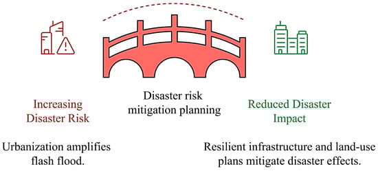
Figure 7.
Conceptual bridge from growing HDR risk to reduced impact. Left: urban expansion over hazard hotspots elevates flash-flood risk. Center: evidence-led planning using HDR recurrence masks, the high-intensity zone, and exposure forecasts. Right: outcomes from targeted measures, zoning that steers growth to safer terrain, drainage and detention upgrades, blue–green infrastructure, slope-stability works, and strengthened early-warning.
Reliance on CHIRPS at 0.05° may under-detect sub-kilometer convective bursts over glacierized headwaters, despite IMD gauge cross-validation. GHSL’s 100 m resolution risk under-represent sparse hamlets on steep ground; an acknowledged limitation partially offset here by a 5% impervious threshold [26]. The LSTM assumes stationarity in the rainfall–exposure relationship; therefore, step changes in either land-use policy or climate forcing could reduce predictive skill. Integrating higher-resolution precipitation (e.g., IMERG half-hourly) and incorporating CMIP6 ensemble projections would improve both hazard characterization and non-stationary forecasting [1,39,40]. Hybrid architectures that merge LSTM sequence learning with convolutional encoders could further enhance spatiotemporal modeling while retaining interpretability [41]. Overall, this study aimed to investigate the increase in HDR exposure, driven primarily by urbanization, within a geographically stable, high-intensity belt. The mapped 31,555.26 km2 high-intensity zone, overlapped against 37,897.04 km2 of no-event terrain, provides an empirical approach for prioritizing resilient infrastructure investment and directing future growth to lower-risk areas [42]. Incorporating these exposure layers into land-use plans, coupled with drainage and early warning upgrades tailored to recurrent hotspots, represents the most immediate pathway toward reducing the compound flash flood, landslides [43,44,45] and debris-flow risk facing Jammu, Kashmir, and Ladakh in a warming, urbanizing mountain environment, and at the same time helping in the stability food security and coping with the socio-vulnerability in the region [46,47].
5. Conclusions
This study offers a comprehensive, data-driven portrait of HDR and its intersection with the rapidly urbanizing landscape of Jammu, Kashmir, and Ladakh. By integrating daily CHIRPS precipitation, 100-m GHSL built-up fractions, and an LSTM forecasting framework within the GEE environment, this study reconstructs two decades of exposure, identifies a persistent high-intensity belt, and projects the trajectory of future risk. Between 2000 and 2020, the number of grid cells receiving at least 100 mm of rain in a single day increased markedly, particularly after 2010. These extremes were not randomly distributed; instead, they were concentrated along a south-western mountain front and the Kashmir Valley floor, with two pixel-scale hotspots near Srinagar and Baramulla recurring in more than two-thirds of the annual maps. The high-intensity footprint, encompassing 31,555 km2, represented nearly half of the study domain. Within this belt, the built-up area exposed to HDR totals increased from 45 km2 at the start of the record to 72 km2 in 2020, yielding a cumulative exposure of 828 km2. The strongest single-year excursions, recorded in 2010, 2012, and 2014, coincided with Western Disturbance outbreaks and locally vigorous convection, demonstrating how synoptic forcing and orographic uplift combine to enlarge the hazard footprint precisely where urban densification is most pronounced. A threshold experiment confirmed that the Indian standard 100 mm day−1 criterion captures the physically relevant upper tail of the daily distribution. Tightening the threshold to 120 mm or relaxing it to 80 mm altered the mapped rainfall area by roughly a factor of two, yet changed cumulative exposure by only approximately ten per cent, highlighting the coincidence between dense settlement and the core of the hazard field. Forecasting experiments indicated that if current land-use trajectories persist, the area of built-up surface intersecting HDR is likely to increase from approximately 320 km2 in 2021 to approximately 420 km2 by 2030. This projected rise occurs in the absence of any long-term increase in total annual precipitation, indicating that urban expansion, rather than intensifying rainfall, is the dominant driver of escalating exposure. These findings have direct implications for regional planning and civil protection. The mapped high-intensity belt should be prioritized for enhanced drainage capacity, slope stability works, and HDR-aware building regulations, whereas the contiguous no-event terrain, totaling almost 38,000 km2, offers a preliminary guide for steering future growth toward lower-risk corridors. The cumulative exposure mask provides a ready spatial layer for flash flood guidance thresholds, and the year-ahead LSTM trajectory provides a quantitative target for scaling emergency response resources and infrastructure investment. Despite some good results, we acknowledge the limitations of this study. Daily CHIRPS may miss sub-kilometer burst cores in glacierized headwaters, and the GHSL’s 100-m resolution is prone to under-representing sparse hamlets on steep ground, despite the impervious-surface threshold applied here. Moreover, the LSTM model assumes a stationary relationship between rainfall extremes and urban encroachment; abrupt policy shifts or nonlinear climate change could erode predictive skill. Future research should therefore incorporate higher-resolution precipitation products, ensemble climate projections, and hybrid deep-learning architectures capable of capturing non-stationary behavior, while ground-truthing exposure masks against systematic damage inventories to translate the present exposure metric into a more comprehensive risk framework. Despite these caveats, this study demonstrates that fine-scale Earth-observation data, when combined with machine-learning time-series models, can provide actionable insights into the evolving geography of extreme rainfall exposure in data-sparse mountain regions. Embedding the resulting spatial layers and forecasts into statutory land-use plans, infrastructure design codes, and real-time warning systems would provide an immediate, evidence-based path toward reducing the compound flash flood and debris-flow hazard currently facing the Himalayan urban corridor of Jammu, Kashmir, and Ladakh, as well as its adjoining regions.
Author Contributions
Conceptualization, S.K.S. and D.D.; methodology, Z.A.D.; software, N.K.; validation, B.Đ.; formal analysis, P.K., S.K. and G.M.; investigation, Z.A.D.; resources, B.S. and P.K.; data curation, S.K.S.; writing—original draft preparation, S.K.; writing—review and editing, G.M.; visualization, D.D.; supervision, S.K.G.; project administration, N.K.; funding acquisition, D.D. All authors have read and agreed to the published version of the manuscript.
Funding
This research received no external funding.
Institutional Review Board Statement
Not applicable.
Data Availability Statement
All data are available from the corresponding authors upon reasonable request.
Acknowledgments
The authors would like to thank the University of North, Croatia, for supporting the research within the scientific project ‘’Comparing LiDAR data with publicly available datasets’’, from 2025. The authors have reviewed and edited the output and take full responsibility for the content of this publication. The authors would like to express their sincere gratitude to the two anonymous reviewers for their constructive and insightful comments, which substantially improved the quality of this manuscript. The authors would like to thank the two anonymous reviewers and the editor for their valuable comments on the earlier versions of this manuscript that helped us to improve the quality of our work.
Conflicts of Interest
The authors declare that they have no conflicts of interest.
References
- IPCC. 2021: Summary for Policymakers. In Climate Change 2021: The Physical Science Basis. Contribution of Working Group I to the Sixth Assessment Report of the Intergovernmental Panel on Climate Change; Masson-Delmotte, V., Zhai, P., Pirani, A., Connors, S.L., Péan, C., Berger, S., Caud, N., Chen, Y., Goldfarb, L., Gomis, M.I., et al., Eds.; IPCC: Geneva, Switzerland, 2021; Available online: https://www.ipcc.ch/report/ar6/wg1/chapter/summary-for-policymakers/ (accessed on 5 June 2025).
- Nagamani, K.; Mishra, A.K.; Meer, M.S.; Das, J. Understanding flash flooding in the Himalayan Region: A case study. Sci. Rep. 2024, 14, 7060. [Google Scholar] [CrossRef]
- Dar, T.; Aziz, K. Assessment and Management of Flash Floods in the India Himalayas. In Water Resources Management in Mountain Regions; Wiley: Hoboken, NJ, USA, 2025; pp. 301–317. ISBN 9781394249619. [Google Scholar]
- Dimri, A.P.; Niyogi, D.; Barros, A.P.; Ridley, J.; Mohanty, U.C.; Yasunari, T.; Sikka, D.R. Western Disturbances: A review. Rev. Geophys. 2015, 53, 225–246. [Google Scholar] [CrossRef]
- Murata, F.; Terao, T.; Chakravarty, K.; Syiemlieh, H.J.; Cajee, L. Characteristics of Orographic Rain Drop-Size Distribution at Cherrapunji, Northeast India. Atmosphere 2020, 11, 777. [Google Scholar] [CrossRef]
- Bhat, A.A.; Dhondiram, P.D.; Gupta, S.K.; Kanga, S.; Singh, S.K.; Meraj, G.; Kumar, P.; Sajan, B. Snow Resources and Climatic Variability in Jammu and Kashmir, India. Climate 2025, 13, 28. [Google Scholar] [CrossRef]
- Maftei, C.; Muntean, R.; Vaseashta, A. Modeling and Monitoring Extreme Hydrometeorological Events; IGI Global: Hershey, PA, USA, 2024; ISBN 9781668487716. [Google Scholar]
- Hansen, M.C.; Potapov, P.V.; Moore, R.; Hancher, M.; Turubanova, S.A.; Tyukavina, A.; Thau, D.; Stehman, S.V.; Goetz, S.J.; Loveland, T.R.; et al. High-Resolution Global Maps of 21st-Century Forest Cover Change. Science 2013, 342, 850–853. [Google Scholar] [CrossRef]
- Ranjitkar, S.; Kindt, R.; Sujakhu, N.M.; Hart, R.; Guo, W.; Yang, X.; Shrestha, K.K.; Xu, J.; Luedeling, E. Separation of the bioclimatic spaces of Himalayan tree rhododendron species predicted by ensemble suitability models. Glob. Ecol. Conserv. 2014, 1, 2–12. [Google Scholar] [CrossRef]
- Wang, X.; Xie, H. A Review on Applications of Remote Sensing and Geographic Information Systems (GIS) in Water Resources and Flood Risk Management. Water 2018, 10, 608. [Google Scholar] [CrossRef]
- Kranjčić, N.; Medak, D.; Župan, R.; Rezo, M. Support Vector Machine Accuracy Assessment for Extracting Green Urban Areas in Towns. Remote Sens. 2019, 11, 655. [Google Scholar] [CrossRef]
- Zhang, G.; Wang, M.; Liu, K. Forest Fire Susceptibility Modeling Using a Convolutional Neural Network for Yunnan Province of China. Int. J. Disaster Risk Sci. 2019, 10, 386–403. [Google Scholar] [CrossRef]
- Hochreiter, S.; Schmidhuber, J. Long Short-Term Memory. Neural Comput. 1997, 9, 1735–1780. [Google Scholar] [CrossRef]
- Ouma, Y.O.; Cheruyot, R.; Wachera, A.N. Rainfall and runoff time-series trend analysis using LSTM recurrent neural network and wavelet neural network with satellite-based meteorological data: Case study of Nzoia hydrologic basin. Complex Intell. Syst. 2022, 8, 213–236. [Google Scholar] [CrossRef]
- Khosravi, Y.; Ouarda, T.B. Drought risks are projected to increase in the future in central and southern regions of the Middle East. Commun. Earth Environ. 2025, 6, 384. [Google Scholar] [CrossRef]
- Zhu, Z.; Wang, S.; Woodcock, C.E. Improvement and expansion of the Fmask algorithm: Cloud, cloud shadow, and snow detection for Landsats 4–7, 8, and Sentinel 2 images. Remote Sens. Environ. 2015, 159, 269–277. [Google Scholar] [CrossRef]
- Liu, Z.; Yao, Z.; Wang, R. Assessing methods of identifying open water bodies using Landsat 8 OLI imagery. Environ. Earth Sci. 2016, 75, 873. [Google Scholar] [CrossRef]
- Mondal, A.; Khare, D.; Kundu, S. Spatial and temporal analysis of rainfall and temperature trend of India. Theor. Appl. Clim. 2015, 122, 143–158. [Google Scholar] [CrossRef]
- Das, L.; Meher, J.K. Drivers of climate over the Western Himalayan region of India: A review. Earth-Science Rev. 2019, 198, 102935. [Google Scholar] [CrossRef]
- Hekmat, H.; Ahmad, T.; Singh, S.K.; Kanga, S.; Meraj, G.; Kumar, P. Land Use and Land Cover Changes in Kabul, Afghanistan Focusing on the Drivers Impacting Urban Dynamics during Five Decades 1973–2020. Geomatics 2023, 3, 447–464. [Google Scholar] [CrossRef]
- Meraj, G. Assessing the Impacts of Climate Change on Ecosystem Service Provisioning in Kashmir Valley India. Ph.D. Thesis, Suresh Gyan Vihar University, Jaipur, India, 2021. Available online: http://hdl.handle.net/10603/354338 (accessed on 25 April 2025).
- Funk, C.; Peterson, P.; Landsfeld, M.; Pedreros, D.; Verdin, J.; Shukla, S.; Husak, G.; Rowland, J.; Harrison, L.; Hoell, A.; et al. The climate hazards infrared precipitation with stations—A new environmental record for monitoring extremes. Sci. Data 2015, 2, 150066. [Google Scholar] [CrossRef]
- India Meteorological Department. Heavy Rainfall Warning Services: Operational Guidelines and Classification Thresholds (Brochure). Ministry of Earth Sciences, Government of India. 2021. Available online: https://mausam.imd.gov.in/imd_latest/contents/pdf/pubbrochures/Heavy%20Rainfall%20Warning%20Services.pdf (accessed on 5 June 2025).
- Hirata, H.; Fujinami, H.; Kanamori, H.; Sato, Y.; Kato, M.; Kayastha, R.B.; Shrestha, M.L.; Fujita, K. Multiscale processes leading to heavy precipitation in the eastern Nepal Himalayas. J. Hydrometeorol. 2023, 24, 641–658. [Google Scholar] [CrossRef]
- Pokharel, B.; Wang, S.-Y.S.; Meyer, J.; Marahatta, S.; Nepal, B.; Chikamoto, Y.; Gillies, R. The east–west division of changing precipitation in Nepal. Int. J. Climatol. 2019, 40, 3348–3359. [Google Scholar] [CrossRef]
- Melchiorri, M. The global human settlement layer sets a new standard for global urban data reporting with the urban centre database. Front. Environ. Sci. 2022, 1–18. [Google Scholar] [CrossRef]
- Bhatt, C.M.; Rao, G.S.; Farooq, M.; Manjusree, P.; Shukla, A.; Sharma, S.V.S.P.; Kulkarni, S.S.; Begum, A.; Bhanumurthy, V.; Diwakar, P.G.; et al. Satellite-based assessment of the catastrophic Jhelum floods of September 2014, Jammu & Kashmir, India. Geomat. Nat. Hazards Risk 2017, 8, 309–327. [Google Scholar] [CrossRef]
- Zappa, G. Regional Climate Impacts of Future Changes in the Mid–Latitude Atmospheric Circulation: A Storyline View. Curr. Clim. Chang. Rep. 2019, 5, 358–371. [Google Scholar] [CrossRef]
- Pandey, A.; Shekhar Sarkar, M.; Palni, S.; Parashar, D.; Singh, G.; Kaushik, S.; Chandra, N.; Costache, R.; Pratap Singh, A.; Pratap Mishra, A.; et al. Multivariate statistical algorithms for landslide susceptibility assessment in Kailash Sacred landscape, Western Himalaya. Geomat. Nat. Hazards Risk 2023, 14, 2227324. [Google Scholar] [CrossRef]
- Emanuel, K.A. Atmospheric Convection; Oxford University Press: New York, NY, USA, 1994. [Google Scholar]
- Doswell, C.A. Severe Convective Storms—An Overview. Meteorol. Monogr. 2001, 28, 1–26. [Google Scholar] [CrossRef]
- Walsh, C.J.; Roy, A.H.; Feminella, J.W.; Cottingham, P.D.; Groffman, P.M.; Morgan, R.P. The urban stream syndrome: Current knowledge and the search for a cure. J. N. Am. Benthol. Soc. 2005, 24, 706–723. [Google Scholar] [CrossRef]
- Guan, M.; Sillanpää, N.; Koivusalo, H. Storm runoff response to rainfall pattern, magnitude and urbanization in a developing urban catchment. Hydrol. Process 2016, 30, 543–557. [Google Scholar] [CrossRef]
- Smith, R.B. The Influence of Mountains on the Atmosphere. In Advances in Geophysics; Saltzman, B.B.T., Ed.; Elsevier: New York, NY, USA, 1979; Volume 21, pp. 87–230. ISBN 0065-2687. [Google Scholar]
- Houze, R.A., Jr. Cloud Dynamics, 2nd ed.; Academic Press: San Diego, CA, USA, 2014; ISBN 9780123742667. [Google Scholar]
- Bonan, G.B. Forests and Climate Change: Forcings, Feedbacks, and the Climate Benefits of Forests. Science 2008, 320, 1444–1449. [Google Scholar] [CrossRef] [PubMed]
- Nations, U. Sendai Framework for Disaster Risk Reduction 2015–2030; United Nations: Sendai, Japan, 2015. [Google Scholar]
- Ahern, J.; Cilliers, S.; Niemelä, J. The concept of ecosystem services in adaptive urban planning and design: A framework for supporting innovation. Landsc. Urban Plan. 2014, 125, 254–259. [Google Scholar] [CrossRef]
- Feng, Z.; Houze, R.A.; Leung, L.R.; Song, F.; Hardin, J.C.; Wang, J.; Gustafson, W.I.; Homeyer, C.R. Spatiotemporal Characteristics and Large-Scale Environments of Mesoscale Convective Systems East of the Rocky Mountains. J. Clim. 2019, 32, 7303–7328. [Google Scholar] [CrossRef]
- Barik, K.K.; Mishra, V.; Mohanty, J.R.; Debbarma, M.K.; Barik, R.K. Cloud GIS Model for Coastal Geospatial Big Data Analytics. In BT—Data Science in Societal Applications: Concepts and Implications; Rautaray, S.S., Pandey, M., Nguyen, N.G., Eds.; Springer Nature: Singapore, 2022; pp. 1–11. ISBN 978-981-19-5154-1. [Google Scholar]
- Kumar, R.; Bhanu, M.; Mendes-Moreira, J.; Chandra, J. Spatio-Temporal Predictive Modeling Techniques for Different Domains: A Survey. ACM Comput. Surv. 2024, 57, 1–42. [Google Scholar] [CrossRef]
- Sun, Y.; Chen, X.; Wu, J.; Yuan, H.; Shi, H.; Zhan, X.; Zhang, L. Development of a multi-view and geo-event-driven real-time collaborative GIS. Int. J. Digit. Earth 2022, 15, 134–147. [Google Scholar] [CrossRef]
- Kaiser, Z.R.M.A.; Akter, F. From risk to resilience and sustainability: Addressing urban flash floods and waterlogging. Risk Sci. 2025, 1, 100011. [Google Scholar] [CrossRef]
- Glade, T. Landslide occurrence as a response to land use change: A review of evidence from New Zealand. CATENA 2003, 51, 297–314. [Google Scholar] [CrossRef]
- Zhou, L.; Liu, L. Enhancing dynamic flood risk assessment and zoning using a coupled hydrological-hydrodynamic model and spatiotemporal information weighting method. J. Environ. Manag. 2024, 366, 121831. [Google Scholar] [CrossRef]
- Bhat, A.A.; Gupta, S.K.; Singh, S.K.; Meraj, G.; Kumar, P.; Kanga, S.; Singh, S.; Sajan, B. Simulating Climatic Patterns and Their Impacts on the Food Security Stability System in Jammu, Kashmir and Adjoining Regions, India. Climate 2024, 12, 99. [Google Scholar] [CrossRef]
- Cutter, S.L.; Boruff, B.J.; Shirley, W.L. Social Vulnerability to Environmental Hazards. Soc. Sci. Q. 2003, 84, 242–261. [Google Scholar] [CrossRef]
Disclaimer/Publisher’s Note: The statements, opinions and data contained in all publications are solely those of the individual author(s) and contributor(s) and not of MDPI and/or the editor(s). MDPI and/or the editor(s) disclaim responsibility for any injury to people or property resulting from any ideas, methods, instructions or products referred to in the content. |
© 2025 by the authors. Licensee MDPI, Basel, Switzerland. This article is an open access article distributed under the terms and conditions of the Creative Commons Attribution (CC BY) license (https://creativecommons.org/licenses/by/4.0/).