Article

Transient Fish Occurrence Following Flood-Induced Backflow in a Managed Wetland: Implications for Invasion Surveillance and Monitoring Design


by
Yasufumi Fujimoto
The Miyagi Prefectural Izunuma-Uchinuma Environmental Foundation, 17-2 Shikimi, Wakayanagi, Kurihara 989-5504, Miyagi, Japan
Conservation 2026, 6(3), 82; https://doi.org/10.3390/conservation6030082
Submission received: 2 May 2026 / Revised: 1 July 2026 / Accepted: 2 July 2026 / Published: 4 July 2026

Abstract

Flood-driven hydrological connectivity in managed floodplain wetlands can create transient opportunities for fish dispersal, yet direct field observations of such events remain limited. In Lake Izunuma–Uchinuma, Japan, a rapid water-level rise and temporary backflow from a downstream river were recorded during a flood event, followed by the first detection of the bagrid catfish Tachysurus nudiceps. Its occurrence outside its natural range may pose significant conservation concerns, particularly habitat competition with native congeneric species. The temporal coincidence between the flood and species detection is consistent with potential passive transport into the lake via temporary backflow. Subsequent routine surveys, including stationary net sampling and environmental DNA (eDNA) analysis, did not detect the species, suggesting either a transient occurrence or an abundance below the detection threshold of conventional monitoring. These findings indicate that short-lived occurrences or low-abundance inflow events may escape conventional, pre-scheduled monitoring, potentially undermining local conservation efforts. We therefore propose that invasion surveillance in managed wetlands should include hydrological information and event-based sampling, especially after extreme rainfall, to enhance conservation strategies and prevent early-stage biological invasions.

1. Introduction

Biological invasions are among the major drivers of biodiversity loss in freshwater ecosystems worldwide, making the prevention and early detection of non-native species a critical priority for conservation ecology [1,2]. In river–floodplain systems, extreme rainfall events can generate floods that temporarily increase hydrological connectivity, thereby creating short-term dispersal pathways for aquatic organisms [3,4,5,6,7,8,9,10]. Both the frequency and intensity of extreme precipitation events are projected to increase under climate change, potentially elevating the invasion risks associated with these transient connections [11,12,13]. However, direct field observations linking flood-driven hydrological connectivity to actual fish introduction events remain scarce.
Floodplain lakes and wetlands managed for flood control and water use differ significantly from natural systems because their hydrological conditions are strongly influenced by water-level regulation and hydraulic infrastructure [11,14]. While natural floodplains typically experience predictable, seasonal connectivity with main river channels [3,4,5,6], the connectivity in managed wetlands is often artificially controlled and episodic [9,13]. However, the invasion ecology of these regulated wetlands remains relatively understudied, representing a critical blind spot in current conservation planning. In contrast to natural lakes, where inflow and outflow pathways generally remain stable, managed floodplain lakes may receive water not only from their primary catchments but also from adjacent catchments through temporary backflow once operational thresholds at hydraulic structures (e.g., sluice gates) are exceeded [9]. Such management-induced connectivity can create unpredictable, transient opportunities for species introductions that are rarely anticipated in conventional biodiversity monitoring.
In invasive species management, Early Detection and Rapid Response (EDRR) is widely recognized as the most cost-effective strategy [15,16]. While management agencies might consider a “wait-and-see” approach for transient occurrences due to immediate financial constraints, the economic and ecological costs of eradication increase exponentially once a population establishes itself. Therefore, detecting transient introductions and identifying their specific pathways during extreme weather events provides immense practical value for preventing massive future management costs.
From a management perspective, most conventional fish monitoring programs are designed to evaluate resident communities under normal flow conditions. Sampling locations typically target representative sites within lakes, whereas hydrological boundary zones, such as inlets, outlets, and areas prone to backflow, are rarely targeted. However, if invasion risks become concentrated at these boundary zones during brief flood events, such static monitoring designs may miss early-stage invasions or transient introductions, ultimately undermining proactive conservation and eradication efforts [14]. In recent years, environmental DNA (eDNA) methods have substantially improved early detection of invasive species [17,18,19,20]. Nevertheless, their effectiveness remains highly sensitive to sampling timing and location relative to extreme hydrological events [18,20].
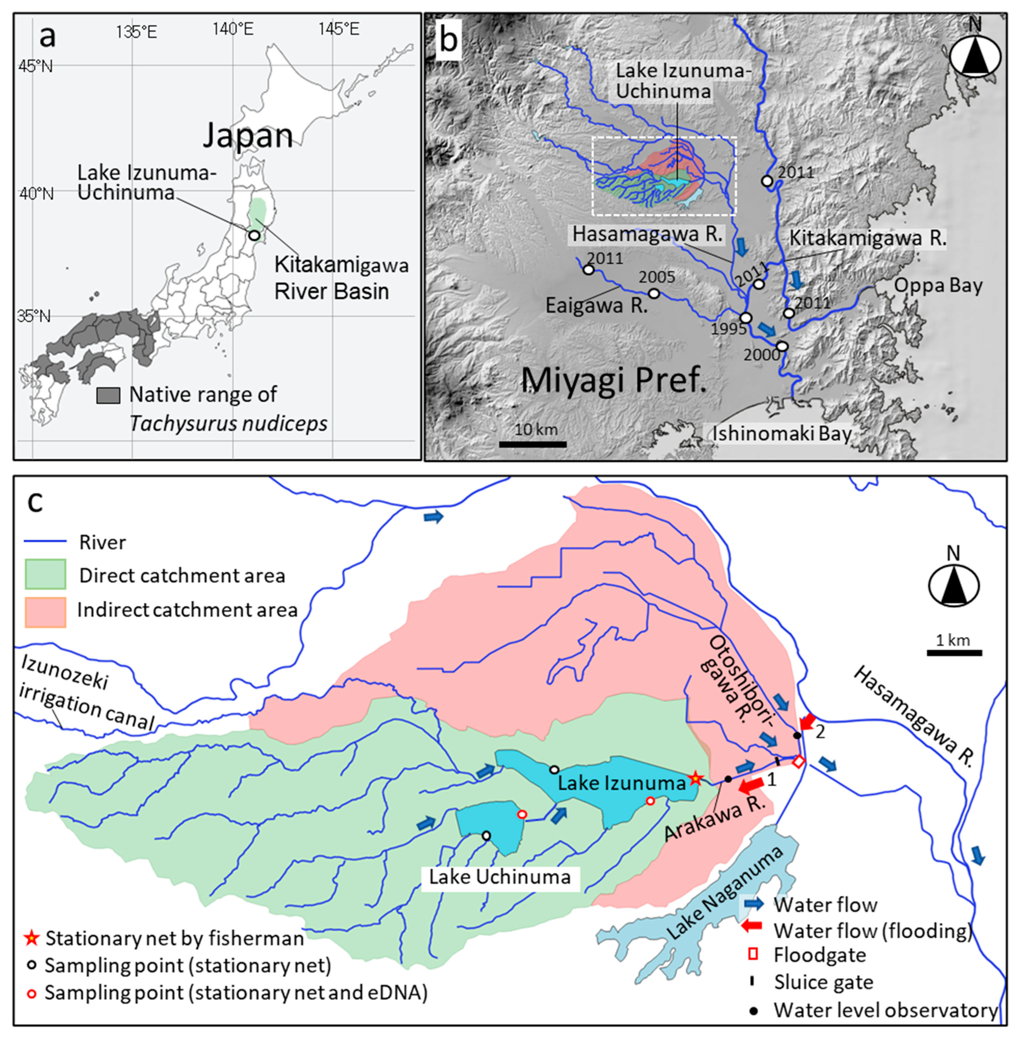
Lake Izunuma–Uchinuma in northeastern Japan is a managed floodplain lake that functions as part of a flood-control system [21]. In early June 2025, following a heavy rainfall event, backflow from a downstream river occurred. Ten days later, two individuals of the bagrid catfish Tachysurus nudiceps (Sauvage, 1883), a species not previously recorded in the lake, were captured near the lake outlet. T. nudiceps is native to western Japan (Figure 1a), and its presence in other regions is considered a domestic introduction. Such introductions may pose significant conservation concerns, particularly regarding potential habitat competition with native congeneric species such as T. tokiensis, as both species share similar habitat requirements and utilize stones or vegetation as shelter. Subsequent standardized surveys, including eDNA monitoring, did not detect the species.
These observations provide an opportunity to examine the interactions between flood-driven hydrological connectivity and monitoring design in managed floodplain lakes. The objectives of this study were therefore (1) to document the first detection of T. nudiceps in Lake Izunuma–Uchinuma and evaluate whether its occurrence was temporally and spatially consistent with flood-driven hydrological connectivity, and (2) to examine the relationship between extreme flood events and the limitations of conventional monitoring design, thereby providing actionable insights for improving conservation surveillance under changing climate conditions.

2. Materials and Methods

2.1. Study Area

This study was conducted in Lake Izunuma–Uchinuma (38°43′ N, 141°06′ E), which is located within the Kitakami River basin in northeastern Japan (Figure 1a). The Kitakami River is the largest river system in the Tohoku region, flowing from Iwate Prefecture to northern Miyagi Prefecture over 249 km and draining a catchment area of 10,150 km2 [21]. In northern Miyagi Prefecture, the Kitakami River flows through a central lowland plain bounded by mountain ranges to the east and west. The surrounding low-lying wetlands have been extensively converted into agricultural land and residential areas, and various water-management infrastructures, including flood-retention basins and drainage facilities, have been constructed. The lower reaches of the Kitakami River exhibit a very gentle riverbed gradient (1/5000–1/17,000), which is typical of floodplain rivers [21]. Because of this geomorphological setting, the basin has historically been highly susceptible to flooding, and large-scale flood-control measures have been implemented for more than 400 years. Moreover, repeated channel modifications and waterway developments during this period have resulted in the formation of a complex river network (Figure 1b).
Lake Izunuma–Uchinuma consists of two lakes connected by an approximately 800 m channel and forms a very shallow freshwater lake system with a surface area of 4.91 km2, a mean depth of 0.77 m, and a maximum depth of 1.6 m (Figure 1c) [22]. Such shallow morphology makes the lake highly sensitive to water-level fluctuations and inflow variations. The lake is a Ramsar-listed wetland and is widely known as an important wintering site for migratory waterfowl, particularly geese and ducks. Izunuma–Uchinuma is a eutrophic lake in which most of the lakebed is covered by fine sediments, and aquatic vegetation such as lotus (Nelumbo nucifera) is widely distributed. Thirty-six fish species have been reported in the lake and its catchment [23]. The fish community is dominated by pollution-tolerant species, such as the topmouth gudgeon (Pseudorasbora parva) and crucian carp (Carassius spp.), although species endemic to eastern Japan, including the small-scale bitterling Acheilognathus typus and the bagrid catfish Tachysurus tokiensis, also exist.
Several rivers and canals flow into Lake Izunuma–Uchinuma from the western side, and the lake drains eastward through the Arakawa River (Figure 1c, blue arrows). Subsequently, the Arakawa River joins the Otoshiborigawa River and eventually flows into the Hasama River. The direct catchment area of Lake Izunuma–Uchinuma is approximately 52.7 km2 (Figure 1c). In addition to this direct drainage basin, the lake is connected to an adjacent catchment area (hereafter referred to as the “indirect catchment”) of approximately 41.9 km2. During flood-control operations, water from this indirect catchment can flow back into the lake through the Otoshiborigawa River owing to temporary backflow conditions. Inflows from this indirect basin have been identified as a factor contributing to lake shallowing and eutrophication in Izunuma–Uchinuma [24].
Two types of water-control structures were installed at the outlet of Lake Izunuma–Uchinuma: a sluice gate used primarily for irrigation management, and a floodgate designed for flood-control operations (Figure 1c). Under normal conditions, the water levels in the lake are regulated through the operation of stoplogs at the sluice gate to supply irrigation water to surrounding rice fields. During high-water events, Lake Izunuma–Uchinuma functions as a flood-control basin with a total storage capacity of approximately 13,900,000 m3 within the Hasama River basin. During flooding, the floodgate is closed to prevent backflow from the main channel of the Hasama River, and water from the indirect catchment, including the Otoshiborigawa River, is temporarily stored in the lake (Figure 1c, red arrow 1). After the water level in the Hasama River decreases, the gates are reopened, and the stored water is gradually released from the lake. In addition, a diversion channel has been constructed to convey excess water to Lake Naganuma when the Hasama River experiences extreme flooding (Figure 1c, red arrow 2). This diversion channel was not activated during the flood event examined in this study, although it was reported to have operated during a major flood event in 2015 [25]. Unlike natural floodplain rivers with extensive lateral buffer zones, the Lake Izunuma–Uchinuma wetland system is highly confined by surrounding dikes and agricultural water-gate operations to protect the local communities, including houses, roads, and rice paddies located close to the shoreline. Consequently, under standard flood management, extreme rainfall events in this system do not typically result in a significant expansion of the surface water area (lateral inundation); instead, floodwaters are primarily accommodated through a rapid, vertical water-level rise within the fixed wetland boundaries, although catastrophic events can lead to levee overtopping and directly threaten the local population.

2.2. Hydrological Monitoring

Water levels were recorded at two public gauging stations located near the outlet of Lake Izunuma and in the downstream reach of the Otoshiborigawa River (station names: Izunuma Outlet “Numakuchi” water-level station and Ochibori water-level station; Figure 1c [26]). Water-level data were obtained at hourly intervals. All water levels are referenced to the Kitakami River Peil (K.P.), which is used as the standard elevation datum in this study. The water-level and rainfall data were collected from 30 May to 3 June 2025, covering the period before and after the rainfall event. Moreover, hourly precipitation data (mm h−1) were obtained from the nearest meteorological station in Kurihara City [27]. Backflow was visually confirmed twice in the field at the lake outlet during high-water conditions, at approximately 10:00 and 14:00 on 1 June.
To estimate the approximate volume of water flowing into the lake due to backflow and the associated lake-level rise, discharge (Q) measurements were conducted near the water-level gauging station installed in the outlet channel. Q was estimated by combining video analysis and field measurements from a short video sequence recorded at 10:00 on 1 June. First, the movement velocity of floating objects on the water surface was measured from the recorded video. Several floating objects moving across a fixed distance in the video were tracked, and their travel distances and elapsed times were used to calculate the surface flow velocity (vsurface). The outlet channel of Lake Izunuma has a relatively simple cross-sectional shape, with both banks reinforced by steep revetments. Under high-water conditions, most of the channel cross-section conveys flow, and the velocity distribution is, therefore, expected to be relatively uniform across the channel. Based on this assumption, the flow velocity was measured at a single central point, which was considered a practical approximation for the measurements.
A structure with known dimensions, visible in the video frame, was used as a spatial reference to estimate the surface velocity. Because the obtained velocity represented surface flow, a correction coefficient of α = 0.85, commonly used in river Q measurements, was applied to estimate the cross-sectional mean velocity (vmean) using the following equation (Equation (1)) [28].
v _ m e a n = 0.85 × v _ s u r f a c e
To estimate the cross-sectional area (A) of the channel, a measuring rod was used to measure the water depth at ten points across the channel. A was calculated based on the average water depth and the channel width. Q was then calculated as the product of vₘₑₐₙ and A (Equation (2)).
Q = A × v _ m e a n
Furthermore, the total volume of inflow caused by backflow (V) was estimated by multiplying Q by the duration of the backflow event (t), which was estimated based on the available hydrological records and the video footage. Finally, the water-level increase attributable to the backflow (Δh) was estimated by dividing the total inflow volume (V) by the surface area (S) of Lake Izunuma–Uchinuma [22] (Equation (3)).
Δ h = ( Q × t ) / S
Of note, because the Q estimation performed in this study was based on a single video observation and a simplified approach combining video analysis and field measurements, rather than continuous and detailed hydrological observations, the values obtained should not be interpreted as precise Q measurements but rather as order-of-magnitude estimates intended to characterize the scale of water exchange that occurred during the flood event.

2.3. Fish Monitoring

Four native species of bagrid catfish exist in Japan, each with a distinct geographical distribution [29]. The natural distribution of T. nudiceps is restricted to western Japan (Figure 1a), and its introduction to other regions has received attention because of potential competition with other native species [30,31].
The Kitakami River basin, where this study was conducted, is located in northeastern Japan. In this basin, fish assemblages have been monitored approximately every five years since 1990 as part of the National Census on River Environments conducted by the National Institute for Land and Infrastructure Management [32]. According to the records of this survey, the first detection of the domestically introduced bagrid catfish T. nudiceps in the basin occurred in 1995 near Kandori Bridge, located 22.3 km upstream from the river mouth (Figure 1b). Because T. nudiceps is a strictly primary freshwater fish lacking salinity tolerance, natural coastal dispersal via marine environments is highly unlikely. Thus, its initial occurrence in the lower basin was likely due to human-mediated inter-basin transport, such as accidental introduction as a contaminant among other stocked fish species. From this initial point of introduction, subsequent surveys conducted in 2000 and 2011 reported a gradual upstream expansion of its distribution, which reached 43.4 km from the river mouth by 2011. More recent surveys in 2016 and 2021 continued to record this species, indicating that the 2011 limit represents the currently confirmed spatial frontier of its upstream distribution. However, the Hasama River system, which connects to Lake Izunuma–Uchinuma and represents a major tributary flowing into the Kitakami River, has not been included in this monitoring program. Consequently, the historical dynamics of fish assemblages and the distribution status of T. nudiceps in this tributary system remain largely unknown.
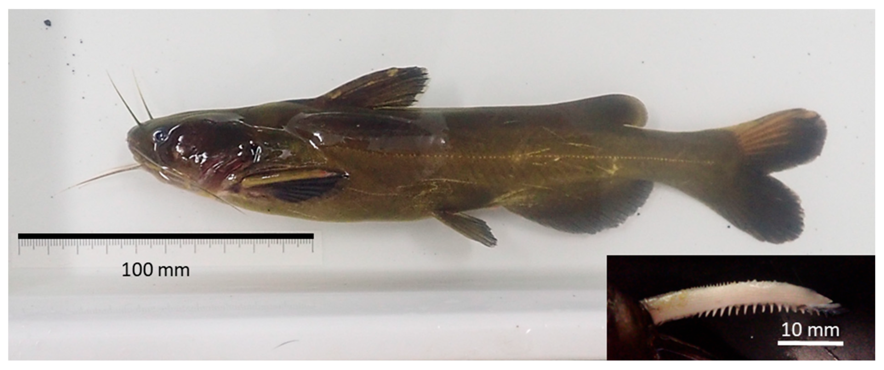
In contrast to the unmonitored Hasama River system, the fish assemblage within Lake Izunuma–Uchinuma itself has been intensively and continuously monitored for over 20 years [33]. These integrated surveillance efforts include routine ecological surveys, extensive trapping through long-term invasive fish eradication programs, monitoring of inflowing rivers, and a collaborative reporting network with local fishers. Despite this exceptionally high surveillance effort, T. nudiceps had never been recorded in the lake prior to this study. Against this background of established absence, around 10 June 2025, two T. nudiceps individuals were captured in a stationary net installed by a local fisher near the lake outlet (Figure 1c, star symbol). Species identification was conducted based on diagnostic morphological characteristics using standard taxonomic keys and comparisons with closely related species [34,35]. Specifically, the specimens were identified as T. nudiceps based on the deeply forked posterior margin of the caudal fin and the serrations on the anterior margin of the pectoral spine restricted to the proximal portion of the spine. These characteristics distinguish T. nudiceps from closely related species such as T. tokiensis, T. aurantiacus, and the Korean species T. koreanus.
To evaluate the resident fish community, routine fish monitoring was conducted from July to August and November to December in both 2024 and 2025. Fish surveys consisted of stationary net sampling and eDNA monitoring. For the stationary net survey, four nets were installed at fixed locations: two in Lake Izunuma and two in Lake Uchinuma (Figure 1c). Each stationary net consisted of a guiding fence net (30 m in length) and a trap net (4 m in length, 0.4 m in diameter, mesh size 4 mm). Nets were deployed for 3–4 d at each site before the fish were collected. This procedure was repeated four times at each site, resulting in 16 net retrievals per sampling period (four sites × four repetitions). The number of individuals of all captured fish species was recorded. For species with a large number of individuals, approximately 10% of the specimens were randomly subsampled, weighed, and used to estimate the total biomass.
All eDNA analyses were conducted following the Environmental DNA Survey and Experimental Manual Ver. 3.01 [36]. Water sampling for eDNA analysis was conducted from July to August and November to December in both 2024 and 2025. Subsequently, the water samples were preserved in benzalkonium chloride and transported to a laboratory, where they were filtered on the same day or the following day. The filters (GF/F glass-fiber filters, 0.7-μm pore size; Cytiva, Tokyo, Japan were stored frozen until DNA extraction. The filtration volume was 250 mL per filter. The eDNA was extracted from the filters by using a DNA extraction kit (DNeasy Blood & Tissue Kit; QIAGEN).
The composition of the fish community was analyzed using DNA metabarcoding with the MiFish primer set (Eurofins Genomics, Tokyo, Japan), following the procedures described in the eDNA Society of Japan manual [36] and by Miya et al. [37]. Polymerase Chain Reaction (PCR) amplification was performed using a T100 thermal cycler (Bio-Rad, Hercules, CA, USA), while sequencing was conducted using an Illumina MiSeq next-generation sequencer (Illumina, San Diego, CA, USA). Sequence data were processed using the software bcl2fastq (v2.20; Illumina) and Claident (v0.9. 0.9.2022.04.28) for sequence assembly and denoising. Species identification was conducted by performing similarity searches against reference sequences using BLASTn provided by the National Center for Biotechnology Information (NCBI), and sequences with a match identity of ≥98.5% were assigned to fish species. This specific threshold was chosen to allow for 1–2 base pair mismatches within the approximately 170 bp target region, thereby accounting for potential intraspecific genetic variations and minor sequencing errors, consistent with standard eDNA metabarcoding approaches established by the MiFish development group [38].

3. Results

3.1. Hydrological Dynamics

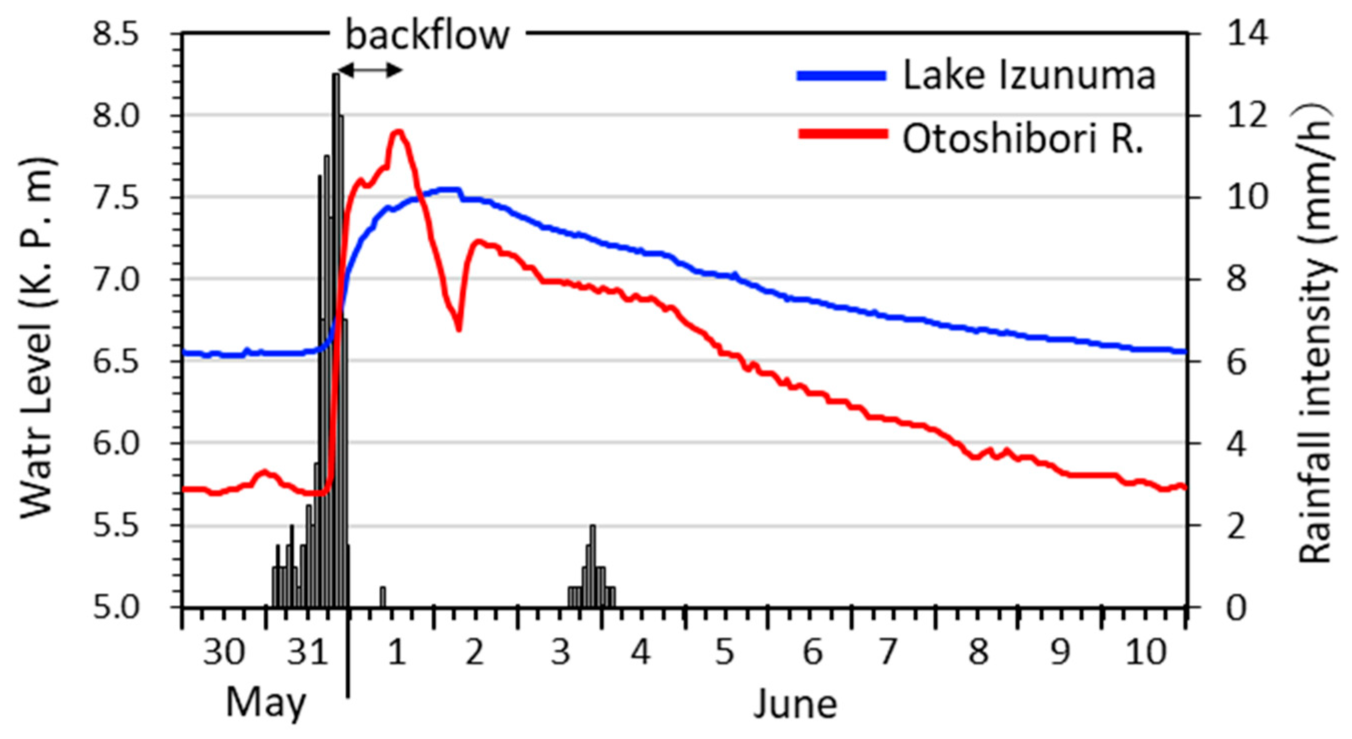
Figure 2 shows the temporal changes in rainfall intensity and water levels in Lake Izunuma and the Otoshiborigawa River from 30 May to 3 June 2025. Rainfall began at approximately 02:00 on 31 May, and the cumulative precipitation reached 105 mm by 24:00 on the same day. Meanwhile, the water level in Lake Izunuma began to rise from K.P. 6.58 m at 16:00 on 31 May and reached a peak of K.P. 7.55 m at 04:00 on 2 June, after which it gradually declined. During this period, the water level of Lake Izunuma–Uchinuma increased by a total of 0.97 m.
The water level of the Otoshiborigawa River was 5.70 m at 16:00 on 31 May but rose rapidly thereafter, reaching 7.90 m at 14:00 on 1 June. Before the rainfall event, the river level was 0.88 m lower than that of Lake Izunuma. However, as the water levels increased, the river level exceeded the lake level at 21:00 on 31 May and remained higher until 20:00 on 1 June. This water-level reversal persisted for 23 h. Subsequently, the water level of the Otoshiborigawa River began declining after 14:00 on 1 June, and field observations at that time indicated that the backflow had nearly ceased. Therefore, the effective duration of the backflow was estimated to be approximately 17 h, from 21:00 on 31 May to 14:00 on 1 June.
Field observations at 10:00 on 1 June indicated that the mean flow velocity during the backflow was 0.765 m s−1. The A value at the observation site was estimated to be approximately 40.0 m2, based on a channel width of 20 m and a mean water depth of 2.03 m. This resulted in an estimated Q of 36.6 m3 s−1 during the backflow event. Assuming that this Q persisted for approximately 17 h, the resulting inflow would correspond to a lake-level increase of approximately 0.39 m for Lake Izunuma–Uchinuma (lake surface area: 4.91 km2). In contrast, the observed lake-level rise during the event was 0.97 m, corresponding to an increase in lake water volume of approximately 4,762,700 m3. Based on these estimates, approximately 0.39 m (40%, about 1,904,556 m3) of the water-level rise was attributable to backflow from the Otoshiborigawa River (Table 1), whereas the remaining 0.58 m (60%, about 2,858,144 m3) was likely derived primarily from inflows from the surrounding catchment and direct precipitation onto the lake surface (Table 1).
Before the flood event, the mean water depth of Lake Izunuma–Uchinuma was 0.85 m, corresponding to a lake volume of approximately 4,173,500 m3. Therefore, the estimated increase in water volume during the flood event (approximately 4,762,700 m3) was comparable to the pre-flood lake volume. During the backflow period, the water levels in the Otoshiborigawa and Arakawa rivers rose synchronously, and the water-level difference between them remained relatively stable (mean ≈ 0.33 m). Thus, the Q estimated from the observation at 10:00 provided a reasonable approximation of the backflow magnitude. By 10 June, the lake water level had returned to the pre-flood level (K.P. 6.58 m). These results indicate that the flood event caused large-scale water exchange in the lake, creating conditions suitable for passive transport from external water bodies, although these hydrological calculations represent order-of-magnitude estimates.

3.2. Fish Monitoring

Ten days after the peak water level, on 10 June 2025, two individuals of T. nudiceps were captured in a stationary net installed by a local fisher approximately 100 m upstream of the outlet of Lake Izunuma (Figure 3). The standard lengths of the two individuals were 201 mm and 193 mm. Based on the diagnostic morphological characteristics described in Section 2.3, these specimens were definitively identified as T. nudiceps [34,35]. As Supplementary Materials, quantitative morphometric and meristic measurements of the specimens were also compatible with T. nudiceps, further distinguishing them from the native T. tokiensis (Table S1).
The specimens were identified as T. nudiceps, based on diagnostic morphological characteristics, including the deeply forked posterior margin of the caudal fin and the serrations on the anterior margin of the pectoral spine restricted to the proximal portion of the spine. These characteristics distinguish T. nudiceps from closely related species such as T. tokiensis, T. aurantiacus, and the Korean species T. koreanus [34,35].
During the four routine survey periods conducted in 2024 and 2025 before and after the detection of T. nudiceps, stationary nets were retrieved 16 times in each period, yielding a total catch of 2931–169,689 fish per survey period across 11–15 species (Table 2 and Table S2). However, no individuals of T. nudiceps were detected at any sampling site in either lake.
The eDNA analyses were conducted during the same four routine survey periods (July–August and November–December in 2024 and 2025), and they produced between 180,536 and 2,092,609 sequence reads per survey, with 9–15 fish species detected (Table 3 and Table S3). However, no sequence reads corresponding to T. nudiceps were detected at any sampling site in either lake.

4. Discussion

4.1. Flood-Associated Hydrological Connectivity and Potential Fish Transport

In this study, a water-level reversal and backflow from the river into the lake were directly observed during a flood event, followed shortly by the first record of T. nudiceps in Lake Izunuma–Uchinuma. These observations suggest that temporary hydrological connectivity during floods may allow fish to enter managed wetlands. The role of flood-driven connectivity in facilitating fish dispersal and invasion has long been recognized, with flood events enhancing organism movement and material exchange across connected habitats [3,4,39,40,41,42,43]. However, direct observations of novel species detections immediately following flood events remain relatively rare, and our study provides an observational case that is consistent with such flood-mediated dispersal opportunities.
Although the actual transport process was not directly observed, several factors—including observed backflow, substantial inflow volume, and the first detection shortly after the flood peak—support this interpretation. In addition, long-term monitoring has not previously recorded this species in the lake, suggesting that flood-driven hydrological connectivity represents a plausible pathway that aligns with the available observations. Although alternative explanations, such as undocumented human-mediated introduction, cannot be entirely excluded (see Section 4.4 for a detailed evaluation), the temporal coincidence among the flood event, backflow, and species detection supports the hypothesis that the detection represented a transient dispersal signal associated with flood-driven connectivity. Floods promote fish movement through increased discharge and expanded connectivity among habitats [44,45,46], although in this case transport was likely passive via backflow rather than active movement. Hydrological estimates indicated that inflow from the indirect catchment accounted for approximately 40% of the total lake-level rise, representing a substantial volume of water entering the lake during the flood event. Although this calculation is an order-of-magnitude estimate based on a single video observation, this estimated contribution (40%) corresponds well with the ratio of their catchment areas; the indirect catchment covers 41.9 km2, which is comparable in scale to the direct catchment of Lake Izunuma (52.7 km2 ). This geographical context provides independent support for the plausibility of our order-of-magnitude estimate. Such large inflows may temporarily increase the probability of fish transport between connected water bodies. In invasion ecology, the probability of successful establishment strongly depends on the number of individuals introduced, a concept commonly referred to as propagule pressure [47,48]. In the present study, the estimated total inflow volume during the flood event was comparable to the pre-flood water volume of Lake Izunuma–Uchinuma. Such large and rapid water exchange events may therefore temporarily increase the likelihood of individual fish being passively transported into the lake.

4.2. Possible Source Population

Freshwater fish assemblages in Japan are strongly determined by drainage systems, and many species exhibit geographically restricted distributions [49]. Consequently, inter-basin movements within the country have recently attracted attention as cases of domestic introduction [50,51]. Although prior presence cannot be completely ruled out, as mentioned in Section 2.3, long-term monitoring has never recorded this species in the lake. In addition to routine fish monitoring, continuous control programs using electrofishing boats to target the largemouth bass Micropterus nigricans have been implemented in the lake [33,52] and, more recently, monitoring approaches combining electrofishing with artificial intelligence have also been introduced [53]. Fish surveys have also been conducted in inflowing rivers, and monitoring programs have been implemented to detect fish drifting from upstream ponds [23,54]. Furthermore, a local information-sharing network with commercial fishers has been established to report unusual fish occurrences [55]. Given this extensive monitoring framework, the absence of previous records suggests that the presence of a stable population of T. nudiceps in Lake Izunuma–Uchinuma prior to the flood event is unlikely.
In the Kitakami River basin, T. nudiceps was recorded to have gradually expanded its distribution upstream between 1995 and 2011 [32]. Because very few fish surveys have been conducted in the Hasama River system, there is currently no information to definitively identify this tributary as the source of the detected individuals. However, considering the documented expansion in the main stem, it is reasonable to hypothesize that the species has similarly expanded its distribution through the Hasama River system to the Otoshiborigawa River during the period when no surveys were conducted. The Otoshiborigawa River provides a mid-reach riverine habitat suitable for this species, whereas Lake Izunuma–Uchinuma is characterized by a muddy, wetland-like environment lacking such flowing-water habitats [56]. Furthermore, T. nudiceps and its congeneric species are strongly benthic and generally exhibit low mobility, typically inhabiting and spawning within the cover of stones or vegetation in riverine environments [57]. Unlike some freshwater fishes that undertake large-scale active migrations during the summer breeding season [58], they do not possess strong migratory traits. Under normal flow conditions, active upstream migration into the lake is further hindered by the sluice gate at the lake outlet, which has a drop of several tens of centimeters. However, a temporary backflow from the Otoshiborigawa River into Lake Izunuma was observed during the examined flood event. Given the species’ riverine habitat preferences, low mobility, and the physical barrier under normal conditions, their sudden appearance in a lentic environment was likely due to passive transport via this temporary reverse flow rather than active upstream migration.
Although the natural distribution of T. nudiceps is restricted to western Japan, the species has established non-native populations across various regions. This expansion is largely suspected to be linked to the historical translocation of landlocked ayu (Plecoglossus altivelis altivelis) from Lake Biwa [30,31,59]. The invasion of this species raises serious conservation concerns, as introduced T. nudiceps has been reported to displace the native Ariake torrent catfish (T. aurantiacus) through competitive exclusion [59,60,61]. In eastern Japan, including the Lake Izunuma catchment, the native Tokyo torrent catfish (T. tokiensis), which is designated as Vulnerable (VU) on the Red List of the Ministry of the Environment, Japan, occupies a similar ecological niche. Recently, instances of T. nudiceps invading T. tokiensis habitats have been confirmed. Given their high ecological similarity, there is growing concern that T. tokiensis may suffer competitive exclusion similar to that observed in T. aurantiacus [62]. Therefore, the potential establishment of T. nudiceps in Lake Izunuma poses a significant ecological risk to local fish conservation, highlighting the urgent need for early detection and rapid response frameworks.

4.3. Implications for Monitoring

The standardized monitoring program in Lake Izunuma–Uchinuma focused on representative sites within the lake and may therefore have limited ability to detect transient or low-density inflows occurring after extreme events. While effective for long-term monitoring of community composition, it may fail to detect short-lived inflow events immediately after floods. Accordingly, the absence of T. nudiceps in stationary net surveys and eDNA analyses conducted in July–August and November–December does not necessarily confirm the absolute absence of the species or indicate that it failed to enter the lake but may instead reflect a transient occurrence or extremely low abundance. Such detection difficulty and temporal lags during the early stages of biological invasion are widely reported [14].
While eDNA has become a powerful tool for biodiversity monitoring [17,63], its detection sensitivity differs from traditional capture-based methods and strongly depends on sampling location and timing relative to hydrological conditions [64,65]. Stationary nets provide definitive physical evidence of target species but are spatially restricted to specific deployment sites. In contrast, eDNA surveillance covers a broader spatial range by capturing suspended genetic material, yet it is highly susceptible to environmental degradation and dilution. During extreme rainfall and flood events, such as the one examined in this study, a massive influx of river water significantly increases the lake’s water volume. Consequently, even if a small number of individuals enter the lake and release DNA, the rapid increase in water volume can dilute the eDNA concentration below the detection threshold, or the accelerated water turnover (flushing effect) may wash the genetic signals out of the lake. Individuals that appear only briefly during such inflow events may therefore remain undetected by both net sampling and eDNA surveys. The present observation can therefore best be interpreted as a transient dispersal signal associated with potential flood-mediated hydrological connectivity, rather than an established invasion.
This detection difficulty is further compounded by the current status of the local fishery, which accidentally triggered the initial detection of T. nudiceps. Currently, the commercial fishery in Lake Izunuma has significantly declined, decreasing from approximately 50 active fishers four decades ago to only four or five today. Furthermore, these remaining operations are highly small-scale and intermittent, focusing on stationary nets for finfish and shrimp or longlines for eels for only a few dozen days per year. This severe socio-ecological decline means that routine fishery catches cannot be reliably expected to serve as a continuous, real-time early warning network, increasing the risk that transient introduction events remain unnoticed.
Flood-driven dispersal of fish has been widely documented in floodplain river systems, where temporary hydrological connections allow movement between river channels and adjacent wetlands [39,40,41,42,43]. However, in managed wetlands such as Lake Izunuma–Uchinuma, hydrological connectivity may arise through mechanisms that differ from those in natural floodplains. Water-level regulation and artificial outlet structures can generate short-lived connections, particularly during flood events when facility operation and water-level reversals may produce flow directions that differ from normal conditions. Such transient connections can create opportunities for fish inflow that may not be captured by conventional monitoring designs. Because similar water-control structures are widely used, this process may occur broadly in other managed wetland systems.
Considering such temporary hydrological events, monitoring should not only detect species after their arrival but also evaluate conditions under which they may arise. In particular, the combination of flood-driven inflow volume and the abundance of source populations may serve as a useful indicator of invasion risk, consistent with the concept of propagule pressure [46]. At the same time, monitoring aimed at detecting actual inflow events remains essential. Event-based monitoring focused on hydrological boundary zones, such as inlets and outlets, may improve detection of initial inflow during flood events, for example, through eDNA sampling immediately after high-water events, ideally combined with capture-based methods such as the temporary deployment of stationary nets.
The likelihood that flood-driven inflow leads to establishment may depend on species-specific ecological traits. For example, the bagrid catfish T. nudiceps observed in this study typically prefers flowing-water habitats and may therefore have limited potential to establish stable populations in lentic environments. In contrast, species that readily establish in still-water systems, such as largemouth bass M. nigricans, may respond differently. In Lake Izunuma–Uchinuma, where long-term management programs targeting this species have been implemented [33,52], flood-driven inflow of individuals could potentially contribute to the reinforcement of existing populations. These differences suggest that the ecological and management consequences of flood-mediated inflow may vary among species depending on their life-history traits.
During the ten-year period from 2015 to 2024, water-level rises comparable to the event described in this study were recorded at least six times in Lake Izunuma–Uchinuma, indicating that such hydrological connection events are not singular but may occur repeatedly. As extreme rainfall events are projected to increase under climate change, the role of these transient hydrological connections may become increasingly important in shaping invasion dynamics in freshwater ecosystems.
The necessity of actionable and cost-effective management following flood events is strongly supported by the extensive history of invasive species control in the Lake Izunuma–Uchinuma basin. When early detection failed, as in the cases of the invasive freshwater shrimps Neocaridina spp. [66] and Palaemonetes sinensis [67], the species had already become widespread and abundant by the time of first detection, rendering eradication nearly impossible. Conversely, early detection and rapid initial responses successfully eradicated or suppressed invasions of the aquatic plant Eichhornia crassipes [68] and the terrestrial plant Rudbeckia laciniata [69]. Furthermore, anticipating invasion pathways from upstream ponds allowed for the timely development and deployment of specific trapping techniques for bluegill (Lepomis macrochirus), successfully keeping their population under control [70,71,72].
Importantly, identifying the flood-induced backflow pathway via a novel species like T. nudiceps has critical implications for managing already-established invaders. For instance, the lake undergoes intensive, continuous removal of largemouth bass (Micropterus nigricans). As the resident bass population decreases, the relative impact of individuals drifting from outside the watershed increases. Because distinguishing between resident and immigrant bass is technically challenging, the clear evidence of backflow-mediated transport highlights a critical management vulnerability.
Ultimately, the primary value of this case study lies in demonstrating the critical need for wetland managers to recognize extreme hydrological events as transient invasion pathways. Because transient introduction does not necessarily equate to successful establishment, an effective conservation framework must integrate three concurrent steps: (1) profiling high-risk species in potential source waters (e.g., the indirect catchment), (2) detecting actual invasion events at hydrological bottlenecks, and (3) monitoring establishment status in parallel with early control measures. During the initial stages of an invasion, introduced populations typically exhibit highly localized distributions clustered around their points of entry [73,74]. Therefore, a highly actionable and cost-effective management strategy is to spatially concentrate eradication efforts—such as deploying electrofishing boats or targeted netting—specifically around the floodgate areas immediately following a backflow event. Compared to the massive economic burden of lake-wide eradication after a species has dispersed, this localized, event-based response optimizes limited management resources and directly intercepts novel invaders before they can expand.

4.4. Limitations and Alternative Hypotheses

Although this study highlights the vulnerability of conventional monitoring, it is based on a single flood event and the capture of two individuals, which inherently limits the ability to draw definitive causal conclusions regarding the transport process. We cannot completely rule out alternative pathways, such as undocumented anthropogenic release, escape from aquaculture facilities, or migration via agricultural canals. However, this latter pathway is highly unlikely; the Izunozeki irrigation canal, the only major watercourse entering the direct catchment from the outside, diverts water from a hilly area over 40 m higher in elevation than Lake Izunuma, making it topographically implausible for riverine populations to migrate upstream across multiple artificial weirs (Figure 1c). Despite the remaining possibilities of human-mediated introduction, the precise temporal coincidence between the species’ first detection and the temporary backflow makes flood-driven passive transport a plausible and parsimonious explanation for their sudden appearance.
Another alternative hypothesis is the prior presence of a previously undetected, low-density population prior to the flood. However, Lake Izunuma–Uchinuma has been subjected to an intensive, long-term invasive fish eradication program utilizing electrofishing boats, primarily targeting M. nigricans [33,52]. Given this rigorous and continuous physical surveillance, the presence of a well-established population of T. nudiceps prior to the flood event appears unlikely, although a very low-density or recently established population cannot be entirely excluded. No aquaculture facilities or known stocking activities involving T. nudiceps have been documented around the lake, although undocumented releases cannot be excluded.
Regarding the limitations of our eDNA surveys, the routine sampling design missed the critical one- to two-week window immediately following the flood event. Because eDNA degrades rapidly and its detection probability strongly depends on dynamic hydrological conditions, this temporal gap likely reduced our ability to detect the species soon after the flood. Future studies should address these limitations by implementing event-based eDNA sampling immediately after high-water events. Furthermore, the application of genetic markers would also help identify likely source populations and clarify the dispersal pathway of the detected individuals.

5. Conclusions

This study highlights that flood-associated hydrological connectivity in managed floodplain wetlands may create transient opportunities for fish dispersal. The temporal coincidence between rapid water-level rise, temporary backflow, and the detection of T. nudiceps is consistent with potential passive transport via this flood-induced connection, although a definitive causal pathway could not be established from a single event. Because such short-lived occurrences or low-abundance inflow events can easily escape conventional, pre-scheduled monitoring, invasion surveillance in managed wetlands should include hydrological information and event-based sampling, especially after extreme rainfall.

Supplementary Materials

The following supporting information can be downloaded at https://www.mdpi.com/article/10.3390/conservation6030082/s1; Table S1. Morphological and meristic comparison of Tachysurus nudiceps captured in this study and native Tachysurus tokiensis; Table S2. Total species-level catch data collected from two standardized stationary net sites in each lake across two sampling periods per year in Lake Izunuma and Lake Uchinuma (2024–2025); Table S3: Species-level read counts from environmental DNA (eDNA) metabarcoding analyses in Lake Izunuma and Lake Uchinuma (2024–2025).

Funding

This study was conducted as part of the research activities of the River Ecology Research Group of Japan and as part of the “Revive Izunuma and Uchinuma: Native Species Restoration Project” undertaken by Miyagi Prefecture.

Institutional Review Board Statement

Ethical review and approval were not required for this study because it involved field sampling conducted as part of routine invasive species management activities, without experimental manipulation. The study complied with relevant national regulations in Japan, including the Act on Welfare and Management of Animals, where applicable. Although this legislation primarily covers mammals, birds, and reptiles, all procedures were conducted in accordance with its general principles for minimizing animal suffering. All sampling procedures followed standard practices for field-based fish research and management. Fish were handled carefully during capture and measurement, and all efforts were made to minimize stress, injury, and mortality. No procedures involving prolonged restraint, invasive experimentation, or laboratory-based manipulation were performed.

Informed Consent Statement

Not applicable.

Data Availability Statement

Publicly available datasets were analyzed in this study. Meteorological data are available from the Japan Meteorological Agency Past Meteorological Data Search (https://www.data.jma.go.jp/stats/etrn/index.php, accessed on 15 June 2025). River water level data are available from the Ministry of Land, Infrastructure, Transport and Tourism River Disaster Information system (https://www.river.go.jp/, accessed on 15 June 2025). Data from the National Census on River Environments are available via the River Environment Database provided by the National Institute for Land and Infrastructure Management (https://www.nilim.go.jp/lab/fbg/ksnkankyo/, accessed on 1 March 2026). Any additional data supporting the findings of this study are available from the corresponding author upon reasonable request.

Acknowledgments

The author thanks Waga of the Izunuma Fishery Cooperative for providing valuable information on the occurrence of the species. Environmental DNA analysis was conducted by IDEA Consultants, Inc. Field fish surveys were supported by staff of the Miyagi Prefectural Izunuma-Uchinuma Environmental Foundation. The author is grateful to Hiromi Uno (Graduate School of Life Sciences, Tohoku University), Tetsuo Shimada, Hiroki Hayami, and Osamu Nishimura for their valuable advice. The author used ChatGPT (GPT-4o; OpenAI, San Francisco, CA, USA) to assist in drafting, editing, and improving the clarity of the manuscript. The author takes full responsibility for all content, including the accuracy of the data, analyses, and conclusions.

Conflicts of Interest

The author declares no conflicts of interest. The funders had no role in the design of the study; in the collection, analyses, or interpretation of data; in the writing of the manuscript; or in the decision to publish the results.

Abbreviations

The following abbreviations are used in this manuscript:
eDNAEnvironmental DNA
K.P.The Kitakami River Peil
PCRPolymerase Chain Reaction

References

  1. Havel, J.E.; Kovalenko, K.E.; Thomaz, S.M.; Amalfitano, S.; Kats, L.B. Aquatic invasive species: Challenges for the future. Hydrobiologia 2015, 750, 147–170. [Google Scholar] [CrossRef] [PubMed]
  2. Gallardo, B.; Clavero, M.; Sánchez, M.I.; Vilà, M. Global ecological impacts of invasive species in aquatic ecosystems. Glob. Change Biol. 2016, 22, 151–163. [Google Scholar] [CrossRef] [PubMed]
  3. Junk, W.J.; Bayley, P.B.; Sparks, R.E. The flood pulse concept in river-floodplain systems. In Proceedings of the International Large River Symposium; Dodge, D.P., Ed.; Canadian Special Publication of Fisheries and Aquatic Sciences 106; Department of Fisheries and Oceans: Ottawa, ON, Canada, 1989; pp. 110–127. [Google Scholar]
  4. Ward, J.V.; Tockner, K.; Arscott, D.B.; Claret, C. Riverine landscape diversity. Freshw. Biol. 2002, 47, 517–539. [Google Scholar] [CrossRef]
  5. Tockner, K.; Lorang, M.S.; Stanford, J.A. River flood plains are model ecosystems to test general hydrogeomorphic and ecological concepts. River Res. Appl. 2010, 26, 76–86. [Google Scholar] [CrossRef]
  6. Uno, H.; Nakagawa, H.; Ishiyama, N.; Sakai, M.; Mori, T.; Terui, A.; Scholl, E.A.; Wohl, E.; Baxter, C.V. Bridging ecology and geosciences in riverscapes: Implications for process-based restoration. Ecol. Res. 2026, 41, e70028. [Google Scholar] [CrossRef]
  7. Leuven, R.S.E.W.; van der Velde, G.; Baijens, I.; Snijders, J.; van der Zwart, C.; Lenders, H.J.R.; bij de Vaate, A. The River Rhine: A global highway for dispersal of aquatic invasive species. Biol. Invasions 2009, 11, 1989–2008. [Google Scholar] [CrossRef]
  8. Ahmad, H.; Miranda, L.E.; Dunn, C.G.; Boudreau, M.R.; Colvin, M.E. Connectivity patterns between floodplain lakes and neighboring streams in the historical floodplain of the Lower Mississippi River. Ecol. Indic. 2024, 169, 112808. [Google Scholar] [CrossRef]
  9. Fritts, M.; Gibson-Reinemer, D.; Appel, D.; Lieder, K.; Henderson, C.; Milde, A.; Brey, M.; Lamer, J.; Turney, D.; Witzel, Z.; et al. Flooding and dam operations facilitate rapid upstream migrations of native and invasive fish species on a regulated large river. Sci. Rep. 2024, 14, 20609. [Google Scholar] [CrossRef] [PubMed]
  10. Funk, A.; Czeglédi, I.; Erős, T.; Landler, L.; Meulenbroek, P.; Pont, D.; Recinos Brizuela, S.; Valentini, A.; Hein, T. River-floodplain metacommunities as complex networks: The interplay of species interactions, dispersal, and environment. Environ. DNA 2026, 8, e70239. [Google Scholar] [CrossRef]
  11. Radinger, J.; García-Berthou, E. The role of connectivity in the interplay between climate change and the spread of alien fish in a large Mediterranean river. Glob. Change Biol. 2020, 26, 6383–6398. [Google Scholar] [CrossRef] [PubMed]
  12. Rahel, F.J.; Olden, J.D. Assessing the effects of climate change on aquatic invasive species. Conserv. Biol. 2008, 22, 521–533. [Google Scholar] [CrossRef] [PubMed]
  13. Felin, S.; Belliard, J.; Grenouillet, G.; Moatar, F.; Le Pichon, C.; Thieu, V.; Thirel, G.; Jeliazkov, A. The role of river connectivity in the distribution of fish in an anthropized watershed. Sci. Total Environ. 2025, 959, 178204. [Google Scholar] [CrossRef] [PubMed]
  14. Crooks, J.A. Lag times and exotic species: The ecology and management of biological invasions in slow-motion. Écoscience 2005, 12, 316–329. [Google Scholar] [CrossRef]
  15. Leung, B.; Lodge, D.M.; Finnoff, D.; Shogren, J.F.; Lewis, M.A.; Lamberti, G. An ounce of prevention or a pound of cure: Bioeconomic risk analysis of invasive species. Proc. R. Soc. Lond. B Biol. Sci. 2002, 269, 2407–2413. [Google Scholar] [CrossRef]
  16. Cuthbert, R.N.; Diagne, C.; Hudgins, E.J.; Turbelin, A.; Ahmed, D.A.; Albert, C.; Bodey, T.W.; Briski, E.; Essl, F.; Haubrock, P.J.; et al. Biological invasion costs reveal insufficient proactive management worldwide. Sci. Total Environ. 2022, 819, 153404. [Google Scholar] [CrossRef] [PubMed]
  17. Ficetola, G.F.; Miaud, C.; Pompanon, F.; Taberlet, P. Species detection using environmental DNA from water samples. Biol. Lett. 2008, 4, 423–425. [Google Scholar] [CrossRef] [PubMed]
  18. Rees, H.C.; Maddison, B.C.; Middleditch, D.J.; Patmore, J.R.M.; Gough, K.C. The detection of aquatic animal species using environmental DNA: A review of eDNA as a survey tool in ecology. J. Appl. Ecol. 2014, 51, 1450–1459. [Google Scholar] [CrossRef]
  19. Darling, J.A.; Mahon, A.R. From molecules to management: Adopting DNA-based methods for monitoring biological invasions in aquatic environments. Environ. Res. 2011, 111, 978–988. [Google Scholar] [CrossRef] [PubMed]
  20. Çevik, T.; Çevik, N. Environmental DNA (eDNA): A review of ecosystem biodiversity detection and applications. Biodivers. Conserv. 2025, 34, 2999–3035. [Google Scholar] [CrossRef]
  21. Ministry of Land, Infrastructure, Transport and Tourism (MLIT). Basic Policy for River Improvement: Kitakami River System. Available online: https://www.mlit.go.jp/river/basic_info/jigyo_keikaku/gaiyou/seibi/kitakami_index.html (accessed on 8 March 2026).
  22. Lake Izunuma-Uchinuma Nature Restoration Council. Lake Izunuma-Uchinuma Nature Regeneration Project Phase 2. Available online: https://www.pref.miyagi.jp/documents/23928/783455.pdf (accessed on 1 March 2026).
  23. Fujimoto, Y.; Kawagishi, M.; Shindo, K. Freshwater fishes in Lake Izunuma-Uchinuma basin, Japan: Distribution patterns of native species and invasive species. Izunuma-Uchinuma Wetl. Res. 2008, 2, 13–25. (In Japanese) [Google Scholar] [CrossRef]
  24. Miyagi Prefecture Izunuma-Uchinuma Environmental Conservation Measures Review Committee. Report on Environmental Conservation Measures for Lake Izunuma-Uchinuma; Miyagi Prefecture: Sendai, Japan, 1992. [Google Scholar]
  25. Miyagi Prefecture. Overview of Naganuma Dam. Available online: https://www.pref.miyagi.jp/soshiki/et-tmdbk/naganuma-dam-gaiyou.html (accessed on 3 March 2026).
  26. Ministry of Land, Infrastructure, Transport and Tourism (MLIT). River Disaster Information: Observation Data. Available online: https://www.river.go.jp/ (accessed on 15 March 2026).
  27. Japan Meteorological Agency (JMA). Past Meteorological Data Search. Available online: https://www.data.jma.go.jp/stats/etrn/index.php (accessed on 15 March 2026).
  28. Rantz, S.E. Measurement and Computation of Streamflow; U.S. Government Printing Office: Washington, DC, USA, 1982; Volume 1–2.
  29. Watanabe, K.; Nishida, M. Genetic population structure of Japanese bagrid catfishes. Ichthyol. Res. 2003, 50, 140–148. [Google Scholar] [CrossRef]
  30. Watanabe, K.; Mori, S. Pseudobagrus ichikawai: Toward active conservation strategies. Jpn. J. Ichthyol. 2012, 59, 168–171. (In Japanese) [Google Scholar] [CrossRef]
  31. Fujii, R.; Fujii, C.; Fujii, S. First record of Tachysurus nudiceps (Siluriformes: Bagridae) from the Chikugo-gawa River system, Saga Prefecture, Japan. Ichthy Nat. Hist. Fishes Jpn. 2025, 55, 6–8. (In Japanese) [Google Scholar] [CrossRef]
  32. National Institute for Land and Infrastructure Management (NILIM). River Environment Database. Available online: https://www.nilim.go.jp/lab/fbg/ksnkankyo/ (accessed on 15 March 2026).
  33. Fujimoto, Y.; Takahashi, K.; Shindo, K.; Saitoh, K.; Mitsuzuka, M.; Shimada, T. Recovery of the endangered bitterling Acheilognathus typus in Lake Izunuma-Uchinuma after the removal of largemouth bass (Micropterus salmoides). Jpn. J. Ichthyol. 2021, 68, 61–66. (In Japanese) [Google Scholar] [CrossRef]
  34. Nakabo, T. Fishes of Japan with Pictorial Keys to the Species, 3rd ed.; Tokai University Press: Hadano, Japan, 2013. [Google Scholar]
  35. Arayama, K.; Matsuzaki, S.-I.; Mashiko, K.; Hagiwara, T.; Morosawa, T.; Kanou, K.; Watanabe, K. Records and possible population establishment of the non-indigenous bagrid catfish Pseudobagrus fulvidraco in Lake Kasumigaura, Ibaraki Prefecture. Jpn. J. Ichthyol. 2012, 59, 141–146. (In Japanese) [Google Scholar] [CrossRef]
  36. Environmental DNA Society of Japan. Environmental DNA Survey and Experimental Manual, Version 3.01. 2024. Available online: https://ednasociety.org/manual/ (accessed on 1 March 2026).
  37. Miya, M.; Sato, Y.; Fukunaga, T.; Sado, T.; Poulsen, J.Y.; Sato, K.; Minamoto, T.; Yamamoto, S.; Yamanaka, H.; Araki, H.; et al. MiFish, a set of universal PCR primers for metabarcoding environmental DNA from fishes: Detection of more than 230 subtropical marine species. R. Soc. Open Sci. 2015, 2, 150088. [Google Scholar] [CrossRef] [PubMed]
  38. Takeuchi, A.; Sado, T.; Gotoh, R.O.; Watanabe, S.; Tsukamoto, K.; Miya, M. New PCR primers for metabarcoding environmental DNA from freshwater eels, genus Anguilla. Sci. Rep. 2019, 9, 7977. [Google Scholar] [CrossRef] [PubMed]
  39. Pringle, C.M. Hydrologic connectivity and the management of biological reserves: A global perspective. Ecol. Appl. 2001, 11, 981–998. [Google Scholar] [CrossRef]
  40. Amoros, C.; Bornette, G. Connectivity and biocomplexity in waterbodies of riverine floodplains. Freshw. Biol. 2002, 47, 761–776. [Google Scholar] [CrossRef]
  41. Tockner, K.; Pusch, M.; Borchardt, D.; Lorang, M.S. Multiple stressors in coupled river-floodplain ecosystems. Freshw. Biol. 2010, 55, 135–151. [Google Scholar] [CrossRef]
  42. King, A.J.; Humphries, P.; Lake, P.S. Fish recruitment on floodplains: The roles of patterns of flooding and life history characteristics. Can. J. Fish. Aquat. Sci. 2003, 60, 773–786. [Google Scholar] [CrossRef]
  43. Zeug, S.C.; Winemiller, K.O. Ecological correlates of fish reproductive activity in floodplain rivers: A life-history-based approach. Can. J. Fish. Aquat. Sci. 2007, 64, 1291–1301. [Google Scholar] [CrossRef]
  44. Bunn, S.E.; Arthington, A.H. Basic principles and ecological consequences of altered flow regimes for aquatic biodiversity. Environ. Manag. 2002, 30, 492–507. [Google Scholar] [CrossRef] [PubMed]
  45. Lasne, E.; Lek, S.; Laffaille, P. Patterns in fish assemblages in the Loire floodplain: The role of hydrological connectivity and implications for conservation. Biol. Conserv. 2007, 139, 258–268. [Google Scholar] [CrossRef]
  46. Thomaz, S.; Bini, L.; Bozelli, R. Floods increase similarity among aquatic habitats in river-floodplain systems. Hydrobiologia 2007, 579, 1–13. [Google Scholar] [CrossRef]
  47. Lockwood, J.L.; Cassey, P.; Blackburn, T. The role of propagule pressure in explaining species invasions. Trends Ecol. Evol. 2005, 20, 223–228. [Google Scholar] [CrossRef] [PubMed]
  48. Leprieur, F.; Beauchard, O.; Blanchet, S.; Oberdorff, T.; Brosse, S. Fish invasions in the world’s river systems: When natural processes are blurred by human activities. PLoS Biol. 2008, 6, e28. [Google Scholar] [CrossRef] [PubMed]
  49. Watanabe, K. Faunal structure of Japanese freshwater fishes and its artificial disturbance. Environ. Biol. Fishes 2012, 94, 533–547. [Google Scholar] [CrossRef]
  50. Nishida, K.; Kozumi, N.; Satoh, T.; Senga, Y.; Takemura, T.; Watabe, K.; Mori, A. Influence of the domestic alien fish Rhynchocypris oxycephalus invasion on the distribution of the closely related native fish R. lagowskii in the Tama River basin, Japan. Landsc. Ecol. Eng. 2015, 11, 169–176. [Google Scholar] [CrossRef]
  51. Hata, H.; Uemura, Y.; Ouchi, K.; Matsuba, H. Hybridization between an endangered freshwater fish and an introduced congeneric species and consequent genetic introgression. PLoS ONE 2019, 14, e0212452. [Google Scholar] [CrossRef] [PubMed]
  52. Fujimoto, Y.; Takahashi, K.; Shindo, K.; Fujiwara, T.; Arita, K.; Saitoh, K.; Shimada, T. Success in population control of the invasive largemouth bass Micropterus salmoides through removal at spawning sites in a Japanese shallow lake. Manag. Biol. Invasions 2021, 12, 997–1011. [Google Scholar] [CrossRef]
  53. Watanabe, K.; Nguyen-Nhu, T.; Takano, S.; Mori, D.; Fujimoto, Y. Data augmentation for enhanced fish detection in lake environments: Affine transformations, neural filters, SinGAN. Animals 2025, 15, 1466. [Google Scholar] [CrossRef] [PubMed]
  54. Kawagishi, M.; Fujimoto, Y.; Shindo, K. Distribution patterns of fishes in the Lake Izunuma-Uchinuma basin in Miyagi Prefecture, Japan. Izunuma-Uchinuma Wetl. Res. 2008, 2, 63–74. (In Japanese) [Google Scholar] [CrossRef]
  55. Fukuda, K.; Fujimoto, Y. Yellow-toned Amur catfish Silurus asotus collected in Lake Izunuma-Uchinuma, Japan. Izunuma-Uchinuma Wetl. Res. 2022, 16, 97–104. (In Japanese) [Google Scholar] [CrossRef]
  56. Fujimoto, Y.; Takahashi, Y.; Hayami, H.; Nomura, M.; Yokoyama, J.; Shimada, T.; Nishimura, O. Restoring lakeshore vegetation in the face of hysteresis: A water-level and sediment-based strategy for shallow lakes. Water 2025, 17, 1760. [Google Scholar] [CrossRef]
  57. Hosoya, K. (Ed.) Freshwater Fishes of Japan, Revised and Enlarged ed.; Yama-Kei Publishers: Tokyo, Japan, 2019. [Google Scholar]
  58. Fujimoto, Y.; Ouchi, Y.; Hakuba, T.; Chiba, H.; Iwata, M. Influence of modern irrigation, drainage system and water management on spawning migration of mud loach, Misgurnus anguillicaudatus C. Environ. Biol. Fishes 2008, 81, 185–194. [Google Scholar]
  59. Kobayakawa, M. Ariake-gibachi. In Red Data Book 2014—Threatened Wildlife of Japan, Pisces-Brackish and Fresh Water Fishes; Ministry of the Environment, Ed.; GYOSEI Corporation: Tokyo, Japan, 2015; Volume 4, pp. 282–283. (In Japanese) [Google Scholar]
  60. Mizoiri, S.; Takeshita, N.; Nimura, S.; Tabeta, O. Geographical distribution of two bagrid catfishes in Kyushu, Japan. Suisanzoshoku 1997, 45, 497–503. [Google Scholar]
  61. Kumamoto Prefecture Rare Wild Animal and Plant Study Committee. Red Data Book Kumamoto 2019; Kumamoto Prefectural Government: Kumamoto, Japan, 2019. (In Japanese)
  62. Udaka, M.; Yasuhara, S. Additional records of Tachysurus nudiceps (Sauvage, 1883) (Siluriformes: Bagridae), from the Tsurumi River, Kanagawa Prefecture, Japan. Aquat. Anim. 2026, 2026, AA2026-25. (In Japanese) [Google Scholar] [CrossRef]
  63. Thomsen, P.F.; Willerslev, E. Environmental DNA: An emerging tool in conservation for monitoring past and present biodiversity. Biol. Conserv. 2015, 183, 4–18. [Google Scholar] [CrossRef]
  64. Deiner, K.; Bik, H.M.; Mächler, E.; Seymour, M.; Lacoursière-Roussel, A.; Altermatt, F.; Creer, S.; Bista, I.; Lodge, D.M.; de Vere, N.; et al. Environmental DNA metabarcoding: Transforming how we survey animal and plant communities. Mol. Ecol. 2017, 26, 5872–5895. [Google Scholar] [CrossRef] [PubMed]
  65. Harper, L.R.; Buxton, A.S.; Rees, H.C.; Bruce, K.; Brys, R.; Halfmaerten, D.; Read, D.S.; Watson, H.V.; Sayer, C.D.; Jones, E.P.; et al. Prospects and challenges of environmental DNA (eDNA) monitoring in freshwater ponds. Hydrobiologia 2019, 826, 25–41. [Google Scholar] [CrossRef]
  66. Hasegawa, M.; Ikeda, M.; Fujimoto, Y. Distribution of the exotic freshwater shrimp Neocaridina spp. in Miyagi Prefecture and influence on the habitat of native shrimp Paratya compressa improvisa. Izunuma-Uchinuma Wetl. Res. 2015, 9, 47–60. (In Japanese) [Google Scholar] [CrossRef]
  67. Hasegawa, M.; Mori, A.; Fujimoto, Y. Report of the confirmation of foreign fresh water prawns Palaemonetes sinensis which closely resembled the Palaemon paucidens fresh water prawns in Miyagi Prefecture. Izunuma-Uchinuma Wetl. Res. 2016, 10, 59–66. (In Japanese) [Google Scholar] [CrossRef]
  68. Hayami, H.; Fujimoto, Y. A record of Eichhornia crassipes (Mart.) Solms from Lake Izunuma, Miyagi Prefecture, Japan and the possibility of its establishment due to global warming. Izunuma-Uchinuma Wetl. Res. 2022, 16, 33–38. (In Japanese) [Google Scholar] [CrossRef]
  69. Hoshi, M.; Fujimoto, Y.; Shimada, T.; Mori, A.; Ashizawa, J. Result of extermination activities of invasive alien species, cutleaf coneflower Rudbeckia laciniata around Lake Izunuma-Uchinuma in Miyagi Prefecture. Izunuma-Uchinuma Wetl. Res. 2016, 10, 67–76. (In Japanese) [Google Scholar] [CrossRef]
  70. Fujimoto, Y.; Kawagishi, M.; Shindo, K. The distribution of and threat from a population of the invasive species: Bluegill Lepomis macrochirus in the Lake Izunuma-Uchinuma basin, Japan. Izunuma-Uchinuma Wetl. Res. 2007, 1, 21–26. (In Japanese) [Google Scholar] [CrossRef]
  71. Fujimoto, Y.; Takahashi, K.; Sindo, K.; Yambe, H.; Sato, S. Enhancement of the fishing efficiency of the bluegill Lepomis macrochirus by using a trap containing conspecific individuals as decoys. Nippon Suisan Gakkaishi 2010, 76, 913–919. (In Japanese) [Google Scholar] [CrossRef]
  72. Fujimoto, Y.; Kubota, R.; Shindo, K.; Takahashi, K. Downstream dispersal of largemouth bass and bluegill from an irrigation pond. Ecol. Civ. Eng. 2012, 15, 213–219. (In Japanese) [Google Scholar] [CrossRef]
  73. Myers, J.H.; Simberloff, D.; Kuris, A.M.; Carey, J.R. Eradication revisited: Dealing with exotic species. Trends Ecol. Evol. 2000, 15, 316–320. [Google Scholar] [CrossRef] [PubMed]
  74. Britton, J.R.; Gozlan, R.E.; Copp, G.H. Managing non-native fish in the environment. Fish Fish. 2011, 12, 256–274. [Google Scholar] [CrossRef]
Figure 1. Distribution expansion of Tachysurus nudiceps in northeastern Japan and location of the study area. (a) Native distribution of T. nudiceps in Japan and the locations of the Kitakami River basin and Lake Izunuma–Uchinuma. (b) Major rivers of the Kitakami River system in northern Miyagi Prefecture. Circles along the rivers indicate sites where T. nudiceps was recorded in the National Census on River Environments conducted by the Ministry of Land, Infrastructure, Transport and Tourism. The year shown beside each circle indicates the first recorded occurrence at that site. (c) Detailed map of Lake Izunuma–Uchinuma, its catchment, and surrounding rivers. Circles along the lakeshore indicate standardized monitoring sites (stationary net and eDNA sampling locations). The star indicates the stationary net installed by a local fisher where two individuals of T. nudiceps were captured. Blue arrows indicate the normal flow direction, and red arrows indicate flow-direction changes associated with water-management operations during high-water events.
Conservation 06 00082 g001
Figure 2. Rainfall and water-level fluctuations from late May to early June 2025. Bars indicate daily rainfall (mm h−1), and the red and blue lines represent the water levels (m) at Lake Izunuma and the Otoshiborigawa River, respectively. Following rainfall between 31 May and 2–3 June, the lake water level increased rapidly. Arrows at the top of the figure indicate the period during which backflow from the river into the lake was observed.
Conservation 06 00082 g002
Figure 3. Tachysurus nudiceps first recorded in Lake Izunuma on 10 June 2025. The main photograph shows one of the two individuals captured near the lake outlet. Scale bar = 100 mm. The inset at the lower right shows the pectoral fin spine used for species identification. Scale bar = 10 mm.
Conservation 06 00082 g003
Table 1. Estimated water balance during the flood event in Lake Izunuma–Uchinuma.
ComponentWater-Level Equivalent (m)Water Volume (m3)Contribution (%)
Lake volume before flood4.17 × 106
Total inflow during flood event0.974.76 × 106100
Direct catchment inflow0.582.86 × 10660
Backflow from indirect catchment0.391.90 × 10640
Table 2. Summary of results on standardized stationary net monitoring in the Izunuma–Uchinuma lake system (2024–2025).
YearSeasonSampling Effort
(Net-Days)
Total CatchSpecies RichnessTachysurus nudiceps
2024July–August166226130
2024November–December16169,689110
2025July–August162931150
2025November–December16116,846110
Table 3. Metabarcoding read counts by species and sampling event (2024–2025).
YearMonthTotal ReadsSpecies RichnessTachysurus nudiceps
2024July–August180,536150
2024November–December2,092,609120
2025July–August262,299120
2025November–December311,69790
Disclaimer/Publisher’s Note: The statements, opinions and data contained in all publications are solely those of the individual author(s) and contributor(s) and not of MDPI and/or the editor(s). MDPI and/or the editor(s) disclaim responsibility for any injury to people or property resulting from any ideas, methods, instructions or products referred to in the content.