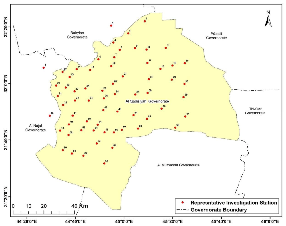
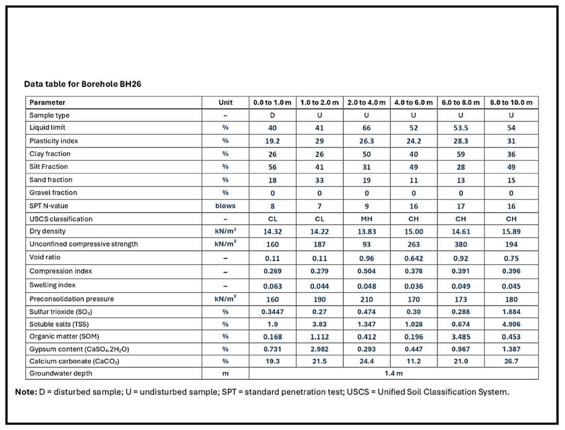
1. Introduction
Finite element modelling has become a standard tool in geotechnical engineering for the analysis of settlement, excavation response, embankment performance, and soil structure interaction [
1,
2,
3]. As numerical modelling has become more common in design and research, greater attention has been given to the selection of constitutive models and the reliability of input parameters [
4,
5]. The predictive quality of a finite element analysis depends not only on mesh design, boundary conditions, and loading assumptions, but also on whether the adopted constitutive parameters adequately represent the compressibility, stress history, and yielding behaviour of the subsurface materials [
6,
7]. This issue is especially important for fine-grained soils, where stress-dependent stiffness, volumetric hardening, and overconsolidation effects strongly influence the response [
8,
9].
Among the constitutive models available for clayey soils, the Modified Cam-Clay model remains one of the most widely used because of its basis in critical state soil mechanics and its relatively compact set of physically meaningful parameters [
10,
11,
12]. In practical applications, the model requires parameters that describe virgin compression, swelling or recompression, initial state, and stress history, commonly expressed through λ, κ,
, preconsolidation pressure, and overconsolidation ratio [
7,
10,
13]. These parameters provide a rational framework for modelling normally consolidated and overconsolidated clay behaviour, and they are implemented in widely used numerical platforms. Despite this theoretical and practical importance, the direct use of Modified Cam-Clay (MCC) in routine engineering remains constrained by parameter availability. In many projects, the available information does not come from a dedicated constitutive testing programme, but from regional or project-based borehole archives containing partial oedometer results, index properties, unit weight data, undrained strength, and field test records. Such datasets often contain useful information, but they are rarely structured in a way that allows direct and traceable conversion into FE-ready constitutive inputs.
A large body of previous research has addressed the determination of Cam-Clay type parameters through laboratory testing, constitutive calibration, and numerical back analysis [
14,
15,
16]. These studies have significantly improved understanding of clay behaviour and model implementation. However, much of that work has focused on high-quality site-specific datasets, advanced laboratory testing, or inverse calibration against case histories. While such approaches are valuable, they do not fully address a common practical problem in geotechnical engineering, namely how to transform incomplete routine investigation records into a standardised material library that can be directly assigned to finite element models. In many engineering settings, the challenge is not the absence of data altogether, but the absence of a transparent workflow that can convert available data into defensible constitutive parameters. Another important stream of research has examined empirical relationships for estimating compressibility-related properties from index tests and routine laboratory measurements. Correlations between liquid limit (LL) and compression index (
), as well as relationships linking void ratio
, plasticity, and consolidation behaviour, have long been used in preliminary geotechnical characterisation [
17,
18,
19]. These correlations are useful when direct measurements are incomplete, but their application in constitutive modelling requires careful standardisation and clear acknowledgement of assumptions. Similarly, preconsolidation pressure
is a key descriptor of stress history, yet in compiled datasets it is often affected by differences in interpretation methods, reporting conventions, or incomplete metadata [
20,
21]. As a result, two major obstacles arise when regional databases are used for constitutive modelling. The first is the need to derive missing or incomplete parameters in a consistent way. The second is the need to preserve engineering meaning so that the resulting parameter set remains suitable for numerical analysis rather than becoming a purely statistical product.
Geotechnical zonation studies provide another relevant background for the present work. Spatial grouping and geographic information system (GIS)-based maps visualisation of subsurface conditions are increasingly used for site characterisation, hazard assessment, and mapping of engineering properties from borehole datasets [
22,
23]. However, many recent GIS-based geotechnical mapping approaches remain focused primarily on stratigraphic description, index classification, standard penetration test (SPT) N-values, bearing capacity, or spatial interpolation of individual engineering variables [
22,
23]. These methods are useful for general ground characterisation, but they do not necessarily produce zones that are directly compatible with constitutive modelling. For finite element (FE) analysis, the objective is not simply to separate soils by description but to identify groups of materials with similar mechanical response under the constitutive law adopted in the model [
7,
16]. A constitutive zone in this sense should be defined by parameters related to compressibility and stress history, not only by stratigraphic or classification labels. This distinction is important because a geological unit may still contain significant variations in overconsolidation ratio (OCR), preconsolidation pressure, or compressibility, all of which strongly influence model response [
24].
A further issue that is often underrepresented in database-driven parameter derivation is the treatment of groundwater in the estimation of initial effective vertical stress. For clay deposits with shallow groundwater, reliance on dry overburden stress alone can distort the estimated stress history and lead to unrealistic OCR values, because OCR is controlled directly by the relationship between preconsolidation pressure and the current effective stress state [
25,
26]. Since OCR directly affects constitutive response in Modified Cam-Clay (MCC), the refinement of effective stress using groundwater conditions is not a secondary adjustment but a necessary part of parameter derivation [
16,
27]. Nevertheless, many compiled borehole datasets are processed without a clear correction strategy for groundwater, particularly when the aim is regional characterisation rather than single-site interpretation. Taken together, the existing literature shows strong development in three related areas, namely constitutive modelling of clays, empirical estimation of compressibility parameters, and geotechnical zonation [
28,
29]. However, a practical gap remains between these areas. There is still limited guidance on how to move from incomplete borehole-based geotechnical records to a finite element-ready constitutive material library through a transparent workflow that includes data cleaning, treatment of missing values, standardisation of preconsolidation pressure, refinement of effective stress using groundwater information, derivation of key constitutive parameters, and grouping into mechanically meaningful constitutive zones. This gap is especially relevant for regional datasets, where the available information may be substantial in volume but inconsistent in format and completeness.
The present study addresses this gap by developing a groundwater-corrected methodology for deriving constitutive input parameters from a regional borehole database of shallow clayey soils. Routine geotechnical and consolidation-related records are used to derive λ, κ, , preconsolidation pressure, initial effective vertical stress, and OCR. The derived parameters are then organised for depth-wise interpretation, GIS-based spatial mapping, material grouping, and finite element (FE) material library development. The purpose is to convert conventional borehole records into a constitutive dataset that is traceable, mechanically interpretable, and directly useful for preliminary finite element modelling.
The objectives of this study are to develop a reproducible workflow for deriving constitutive input parameters from regional borehole and laboratory records, refine the estimation of effective stress and OCR using shallow groundwater conditions, evaluate the vertical and spatial variability of the derived constitutive parameters, and produce representative FE material libraries for practical parameter assignment in numerical modelling. These objectives provide a direct link between routine site investigation records and constitutive model implementation. The study focuses on constitutive input parameters that can be derived from routine borehole and consolidation records and are organised for MCC-based finite element material assignments rather than independent calibration of the full critical state model.
The novelty of this study does not lie in proposing a new constitutive model or a new empirical correlation. Instead, its contribution lies in developing a transparent and reproducible workflow that connects several normally separate stages of geotechnical interpretation into a single FE-oriented framework. The first novel aspect is the conversion of regional borehole archives into a traceable MCC parameter dataset, in which measured, estimated, and completed variables are treated systematically for constitutive use. The second is the incorporation of location-specific groundwater correction before OCR calculation so that the stress-history parameters used for material grouping reflect the effective in situ stress state rather than dry overburden assumptions. The third is the translation of the processed MCC parameter space into practical FE material libraries, reported in both overall and depth-specific forms, together with GIS-based spatial maps that support location-informed parameter selection. In this sense, this study advances the practical use of routine geotechnical archives by transforming scattered borehole records into groundwater-corrected, spatially interpreted, and FE-ready constitutive resources for shallow clayey soils.
3. Methodology
3.1. Data Preparation and Quality Control
The methodological framework adopted in this study was designed to convert routine geotechnical records into a defensible set of constitutive input parameters suitable for finite element modelling. The workflow began with the compilation and standardisation of data extracted from approximately 350 previously completed site investigation reports. From this archive, boreholes were selected on the basis of data usability, reporting consistency, and the availability of the key geotechnical variables required at the target depth intervals of 1, 2, 4, 6, 8, and 10 m below the surface. Before parameter derivation, the database was subjected to a structured quality control procedure. This included harmonisation of variable names and units, checking for duplicate entries, identification of nonphysical values, and screening for obvious transcription or reporting errors. Such steps are consistent with current, established practice in geotechnical data management, where completeness, consistency, traceability, and validation of transferred ground investigation data are essential for reliable downstream interpretation and modelling [
34,
35]. Particular attention was given to parameters that directly affect constitutive interpretation, including dry unit weight, void ratio, recompression index, preconsolidation pressure, and Atterberg limits. Records containing impossible or internally inconsistent values were flagged and reviewed against the broader data pattern. When isolated values could be attributed confidently to entry or reporting errors, corrections were made only where the adjustment was technically evident and consistent with the surrounding dataset. Otherwise, the values were treated as missing. This stage also involved restructuring the data into a form suitable for subsequent derivation, statistical treatment, and constitutive interpretation. The cleaned dataset retained both directly measured variables and variables intended for later estimation, thereby preserving the full information content of the archive while maintaining traceability between observed and derived values. This step was essential because the objective of the study was not merely to summarise geotechnical properties but to generate a modelling-oriented parameter set that could support transparent and reproducible constitutive assignment. Recent work on automated and workflow-based parameter determination for constitutive models similarly emphasises transparency, adaptability, and traceable transformation of source data into modelling inputs [
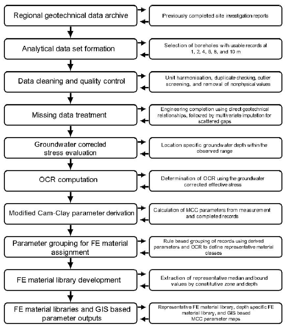
7]. The overall methodological sequence adopted in this study is summarised in
Figure 3.
Figure 3 presents the overall methodological framework adopted in this study to convert a regional geotechnical data archive into FE-ready constitutive inputs. The workflow begins with the selection and standardisation of borehole records, followed by data cleaning, treatment of missing values, and derivation of the principal constitutive parameters. The initial effective vertical stress was refined using the groundwater level assigned to each location within the observed shallow groundwater range, allowing a more realistic calculation of
and OCR. These groundwater-corrected parameters were subsequently used for parameter grouping, FE material library development, and GIS-based spatial interpretation of the key constitutive variables.
3.2. Treatment of Missing Data
Incomplete records are a common feature of regional geotechnical archives, particularly when data are compiled from investigations conducted for different projects, by different laboratories, and under different reporting standards. In the present dataset, missing values were distributed across several variables rather than concentrated in a single field. Discarding all incomplete records would have reduced the regional representativeness of the database and weakened the depth-wise comparisons required for representative material grouping and FE material library development. The proportion of missing values in the variables used for constitutive parameter derivation was low. For all principal variables used in the final constitutive dataset, the missing percentage was less than 3%. The missing entries were scattered among boreholes and depth levels rather than concentrated in a particular location, depth horizon, or single parameter. Because of this low missing-data rate, the treatment strategy was conservative. Direct geotechnical relationships were used first where a physically defined relationship existed, including calculation of PI from LL and PL, and estimation of
from LL where direct compression-index values were unavailable. The few remaining scattered gaps were then completed using multivariate imputation informed by depth, borehole location, index properties, density-related variables, and consolidation parameters. All completed values were flagged separately from directly measured values in the working database. A summary of the missing data percentages and treatment methods for the principal variables used for constitutive parameter derivation is provided in
Table 1.
A structured missing data treatment strategy was therefore adopted. The treatment proceeded in two stages. First, values were estimated using direct geotechnical relationships where a defensible engineering basis existed. Second, the remaining scattered gaps were addressed through multivariate imputation using the broader structure of the database. The imputation process considered the relationships among depth, location, index properties, strength indicators, consolidation parameters, and density-related variables. This approach was adopted because the proportion of missing values was limited relative to the size of the full dataset and because the retained variables exhibited meaningful geotechnical interdependence. Similar motivations underlie recent data management and data-driven geotechnical studies that emphasise preserving dataset continuity while reducing the information loss associated with the deletion of incomplete records [
28,
35]. The purpose of imputation in this study was not to fabricate artificial precision but to preserve the integrity of the regional analytical framework while avoiding unnecessary loss of valid records. All derived and completed values were tracked separately from directly observed data to maintain transparency and reproducibility in the subsequent constitutive parameter derivation. This distinction between observed and completed data is consistent with current expectations for traceable geotechnical data workflows [
35].
3.3. Derivation of Constitutive Input Parameters for MCC-Based FE Modelling
The constitutive parameters required for the present analysis were derived from the cleaned and completed borehole database using standard relationships consistent with MCC interpretation for fine-grained soils [
11,
31]. The principal parameters considered were the virgin compression slope λ, the swelling or recompression slope κ, the initial void ratio
, the preconsolidation pressure
, the initial effective vertical stress
, and the overconsolidation ratio OCR. These parameters were selected because they define the compressibility, stress history, and initial state variables required for constitutive characterisation and subsequent FE implementation. The swelling slope κ was obtained from the recompression index
using Equation (1)
where
is the recompression index expressed in base 10 logarithmic form. This conversion gives the natural logarithm-based parameter required in MCC formulation [
31]. The virgin compression slope λ was derived from the compression index
using Equation (2)
when direct values of
were not available, the compression index was estimated from the liquid limit using the widely adopted empirical relation given in Equation (3)
where LL is the liquid limit expressed as a percentage [
17,
18]. This relation was used as a practical estimation tool for incomplete records, with the recognition that the resulting λ values represent engineering estimates rather than direct laboratory determinations. The initial void ratio
and preconsolidation pressure
were taken from the processed database after quality control and completion of isolated missing entries. Preconsolidation pressure was treated as a key variable because it defines the size of the current yield surface and therefore governs the stress history representation embedded in the Modified Cam-Clay model [
11,
31]. The overconsolidation ratio (OCR) was then calculated using Equation (4)
where
is the initial effective vertical stress at the corresponding sampling depth. Because OCR is highly sensitive to the estimation of
, groundwater correction was incorporated explicitly, as described in the following subsection. The use of these parameters is consistent with constitutive soil modelling practice in nonlinear geotechnical FE analysis, where compressibility and stress history play a controlling role in the predicted soil response [
10].
3.4. Groundwater Corrected Effective Stress and OCR
The study area is characterised by a shallow groundwater table, with recorded groundwater depths ranging from approximately 1.0 to 1.4 m below ground surface across the investigated locations. Because the selected borehole records extend to 10 m depth, a substantial portion of the soil profile lies below the groundwater table. Under such conditions, the use of dry overburden stress alone would overestimate the initial effective vertical stress and, consequently, underestimate the overconsolidation ratio, OCR. Since OCR is a key state variable controlling constitutive response in clay soils, effective stress correction was incorporated explicitly in the parameter derivation workflow [
36]. In this study, the effective stress profile was corrected using the groundwater depth assigned to each investigated location, based on the available field records within the observed regional range of 1.0 to 1.4 m below ground surface. This treatment was adopted to ensure that the calculated initial effective vertical stress,
, reflected the local hydrogeological condition of each borehole rather than a single representative groundwater depth. For depths above the groundwater table, the initial effective vertical stress was estimated as
where
is the dry unit weight and
z is the depth below ground surface. For depths below the groundwater table, the initial effective stress was calculated as the sum of the dry overburden above the water table and the submerged overburden below it, as given in Equation (6)
where
is the groundwater depth below ground surface, and
′ is the submerged unit weight. This expression applies for
. The submerged unit weight was estimated from Equation (7)
where
is the unit weight of water and
Gs is the specific gravity of soil solids. This procedure is consistent with effective stress-based constitutive interpretation and provides a more realistic estimate of the in situ stress state for subsequent OCR calculation and FE material grouping and library development [
37]. The groundwater-corrected effective stress values were then used to calculate OCR for each borehole record at each depth level. By incorporating location-specific groundwater conditions, the resulting OCR profile provides a more defensible representation of stress history than would be obtained from a dry stress approximation. This is especially important in shallow clay deposits, where small changes in effective stress can materially influence the inferred degree of overconsolidation and, therefore, the constitutive classification adopted in finite element modelling [
36].
3.5. Development of the FE Material Library and GIS-Based Constitutive Parameter Maps
The final step of the methodology was the construction of a finite element material library and a set of GIS-based parameter outputs from the groundwater-corrected constitutive parameter dataset and the parameter grouping results. The purpose of this stage was to translate the processed borehole information into forms directly usable in modelling practice and regional geotechnical interpretation. For each constitutive zone, representative values were extracted for λ, κ, , OCR, , and . In addition to central values, lower and upper bound statistics were retained to support sensitivity analysis and parameter selection in design-oriented simulations.
The representative values for each zone were based primarily on robust descriptive statistics, with the median adopted as the principal modelling value and percentile-based bounds used to characterise the likely range of variation. This approach was preferred over simple arithmetic means because the underlying data exhibited natural scatter and moderate asymmetry typical of regional geotechnical datasets. The use of median, lower bound, and upper bound values therefore provided a more stable basis for modelling-oriented parameter selection. Two complementary forms of the FE material library were developed. The first was an overall zone-based library, in which each constitutive zone was represented by a single summary parameter set for regional-scale application. The second was a depth-specific library, in which representative parameter values were reported separately by zone and by standard depth interval. The overall library is suitable for preliminary FE modelling and broad regional characterisation, whereas the depth-specific library provides greater refinement for analyses in which vertical variation must be preserved. In parallel, the derived constitutive parameters were organised into GIS-based spatial outputs for each standard depth level. The GIS-based spatial outputs were generated separately for each standard depth interval using Ordinary Kriging (OK). This method was selected because it uses the spatial correlation structure of the data through variogram modelling and provides both estimated parameter values and an associated interpolation uncertainty. For each MCC parameter and depth level, the borehole point data were projected into a common coordinate system and interpolated over a regular analysis grid covering the study area. Experimental semivariograms were examined and fitted using standard spherical or exponential models, with the final model selected according to the stability of the fitted nugget, sill, and range and the cross-validation performance. The kriging search zone was defined consistently with the fitted variogram range to reduce excessive influence from distant boreholes and to limit local clustering effects. The interpolation was performed on a regular regional analysis grid covering the study area. The grid resolution was selected to support regional interpretation and was not treated as a site-scale measurement resolution. The grid resolution was not intended to imply site-scale precision between boreholes. Interpolation uncertainty was assessed using the kriging standard error and leave-one-out cross-validation, in which each borehole value was temporarily removed and predicted from the surrounding data. The resulting prediction errors were evaluated using mean absolute error and root mean square error. Areas with larger kriging uncertainty or weaker borehole control were interpreted more cautiously. The resulting maps should therefore be understood as regional spatial representations of the derived MCC parameter fields, supporting location-informed parameter selection rather than replacing project-specific ground investigation. The interpolation performance was evaluated using leave-one-out cross-validation. In this procedure, each borehole value was temporarily removed from the dataset, predicted using the remaining borehole values and the fitted kriging model, and then compared with the observed value at the removed location. The prediction errors were summarised using mean absolute error and root mean square error. This procedure was selected instead of permanently withholding a fixed control subset because the objective was to preserve the full regional borehole coverage for the final MCC parameter maps while still providing a quantitative check on interpolation performance. The cross-validation results were used to assess the reliability of the spatial estimates and to identify parameters or depths where the interpolated maps should be interpreted more cautiously. These outputs were developed to support spatial visualisation, engineering interpretation, and location-specific retrieval of parameter values across the study area. In this form, the regional borehole archive is transformed not only into a constitutive material library for FE analysis, but also into a practical geotechnical mapping resource that can assist researchers and designers in identifying representative parameter values at a given location.
Through this procedure, the workflow established a direct connection between routine site investigation data, spatial parameter interpretation, and constitutive model implementation. The final outputs produced in this study are therefore not simply statistical summaries of the borehole archive. Rather, they comprise a modelling-oriented and spatially referenced dataset derived through data cleaning, missing value treatment, groundwater-corrected stress evaluation, constitutive parameter derivation, parameter grouping for FE material assignment, and GIS-supported parameter mapping, with the explicit objective of supporting finite element analyses and regional geotechnical decision-making in shallow clayey deposits.
4. Results
4.1. Overview of the Derived Constitutive Parameter Dataset
The processed site investigation database yielded a complete groundwater-corrected constitutive parameter dataset for all selected depth-specific observations. Following data cleaning, treatment of missing values, and parameter derivation, the final analytical dataset contained values of λ, κ, , , , and OCR across six standard depth levels. This provided a consistent basis for constitutive interpretation, GIS-based spatial mapping, material grouping, and finite element material assignment. The resulting parameter space indicates clear variability in compressibility, density state, and stress history across the shallow clay profile. In particular, the derived values of λ and show that the deposits cannot be represented adequately by a single regional material description, while the groundwater-corrected stress calculations confirm that OCR remains greater than unity over most of the investigated profile. These results demonstrate that the archived site investigation data, once standardised and processed, can be converted into a defensible constitutive dataset suitable for regional geotechnical interpretation, spatial parameter mapping, and modelling-oriented classification. Because the missing percentage of the principal input variables was less than 3%, the completion procedure mainly preserved continuity of the regional depth-specific dataset and did not materially alter the central tendency or engineering interpretation of the derived constitutive parameters.
A compact statistical summary of the final derived dataset is provided in
Table 2. This summary is intended as an overview of the processed parameter space, whereas the depth-related trends and GIS-based spatial distributions of the key constitutive parameters are examined in the following subsections. The summary statistics in
Table 2 indicate moderate overall compressibility and clear variability in state and stress history within the processed dataset. The median values of λ and κ are 0.156 and 0.021, respectively, while the median
is 0.80. The median values of
and
are 170.0 and 52.8 kPa, respectively, yielding a median OCR of 3.41. Overall, the dataset confirms that the investigated shallow clay deposits are predominantly overconsolidated and exhibit sufficient variability in compressibility and stress history to justify subsequent depth-wise analysis, GIS-based spatial mapping, parameter grouping, and FE material library development.
4.2. Depth-Wise Variation in Key Constitutive Parameters
The derived constitutive parameters show systematic variation with depth across the six standard investigation horizons. This depth dependence is particularly evident in λ, , , and OCR, indicating that the shallow clay sequence is mechanically heterogeneous and cannot be represented satisfactorily by a single uniform parameter set. The observed trends are consistent with progressive changes in compressibility, density state, and stress history through the profile. The virgin compression slope, λ, generally increases with depth, indicating that the deeper part of the profile tends to exhibit greater primary compressibility than the near-surface deposits. By contrast, κ remains relatively low and less variable, which is consistent with the narrower range typically associated with swelling and recompression behaviours in clayey soils. This distinction suggests that the most significant vertical change in constitutive response is linked to virgin compression rather than to unloading and reloading characteristics.
The initial void ratio
also shows a clear depth-related pattern, with lower values near the surface and progressively higher values at greater depth. This trend is compatible with the increase in λ, since deeper soils with larger initial void ratios commonly show higher compressibility. The preconsolidation pressure,
, reflects substantial variation between horizons, but when considered together with the groundwater-corrected effective stress, the OCR values show a particularly clear trend. OCR decreases progressively with depth, indicating that the shallowest part of the profile is strongly overconsolidated, whereas deeper horizons remain overconsolidated but to a lesser degree. This depth-wise behaviour is mechanically significant because OCR governs the relative position of the current stress state with respect to the constitutive yield surface and therefore influences stiffness, onset of yielding, and settlement response in MCC analysis. The combined variation of λ,
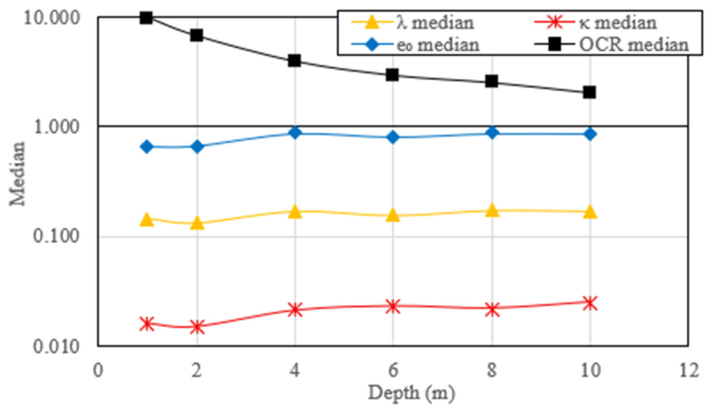
, and OCR confirms that the investigated deposits should be interpreted as a vertically evolving constitutive system rather than as a single homogeneous clay layer. The depth-related trends of the key parameters are summarised in
Table 3 and illustrated in
Figure 4.
Table 3 shows that the constitutive parameters vary systematically with depth. The median value of λ increases overall from the shallow horizon to the deeper part of the profile, while κ remains comparatively low and less variable. The median
also increases with depth, indicating a generally looser and more compressible soil state in the deeper horizons. In contrast, the groundwater-corrected OCR decreases progressively from 9.83 at 1 m to 2.02 at 10 m, confirming that the deposits are overconsolidated throughout the investigated profile but with a clear reduction in stress history effect at depth. These results support the interpretation that the shallow clay sequence is vertically nonuniform and should not be represented by a single constitutive parameter set. From a mechanical perspective, the reduction in OCR with depth indicates a progressive decrease in the influence of previous stress history on the current soil response. The shallow horizons, with high OCR values, are expected to behave predominantly within the recompression range under moderate loading and exert greater apparent stiffness before reaching the yield surface. In contrast, the deeper horizons, although still overconsolidated, have lower OCR values and are therefore closer to the normally consolidated state. These layers are more likely to approach virgin compression under additional foundation or embankment loading. The simultaneous increase in λ and e
0 with depth further supports this interpretation, because higher λ indicates greater virgin compressibility and higher e
0 indicates a looser initial soil state. For FE modelling using MCC, this combination is significant because λ controls plastic volumetric compression, e
0 defines the initial state, and OCR controls the relative position of the current stress state with respect to the yield surface. Therefore, using a single averaged MCC parameter set would obscure the mechanically important contrast between stiff, highly overconsolidated shallow clay and more compressible deeper clay. The depth-specific FE material library is consequently required to represent the vertical evolution of stiffness, yield mobilisation, and settlement response more realistically.
4.3. Spatial Distribution of Key Constitutive Parameters
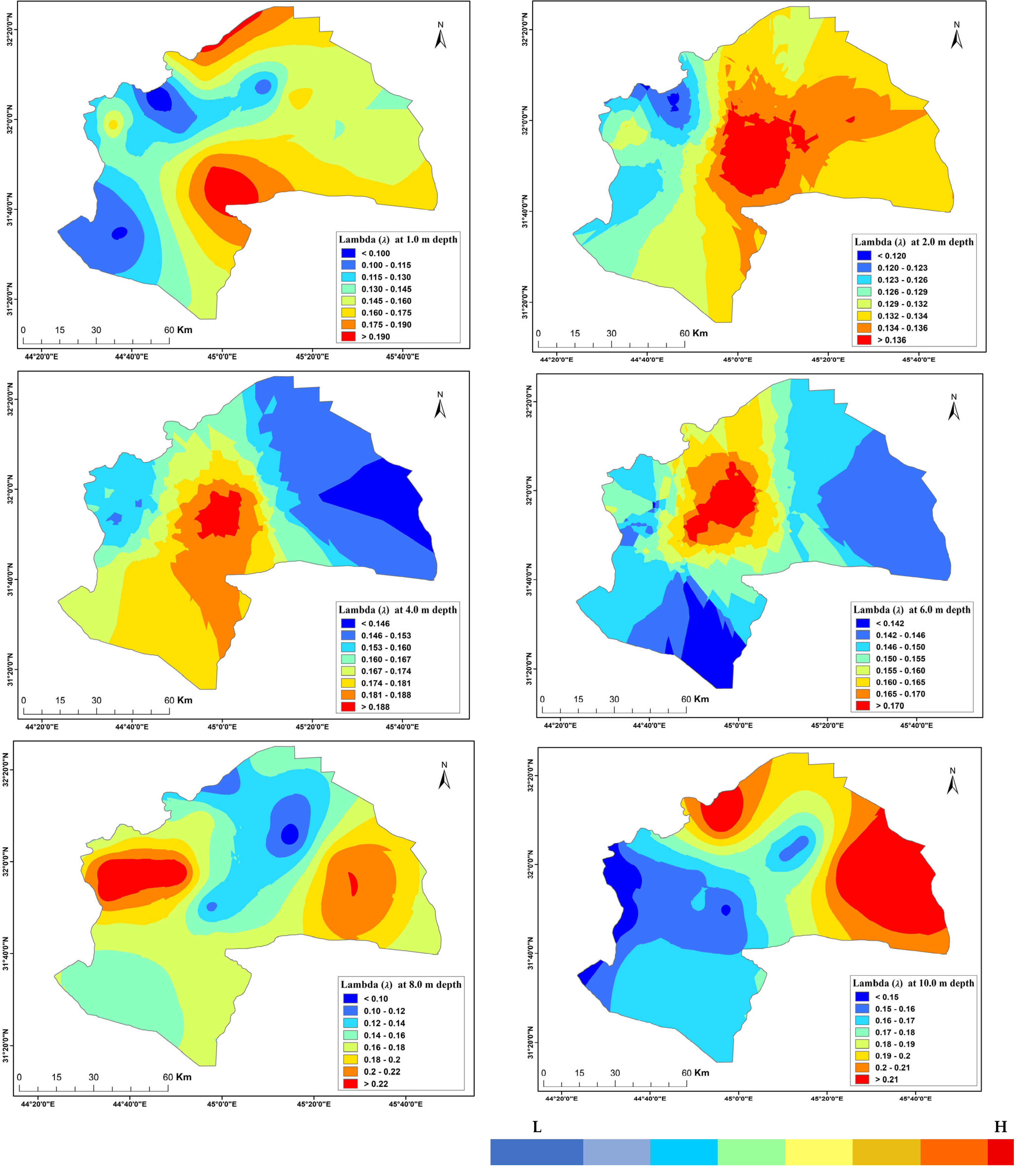
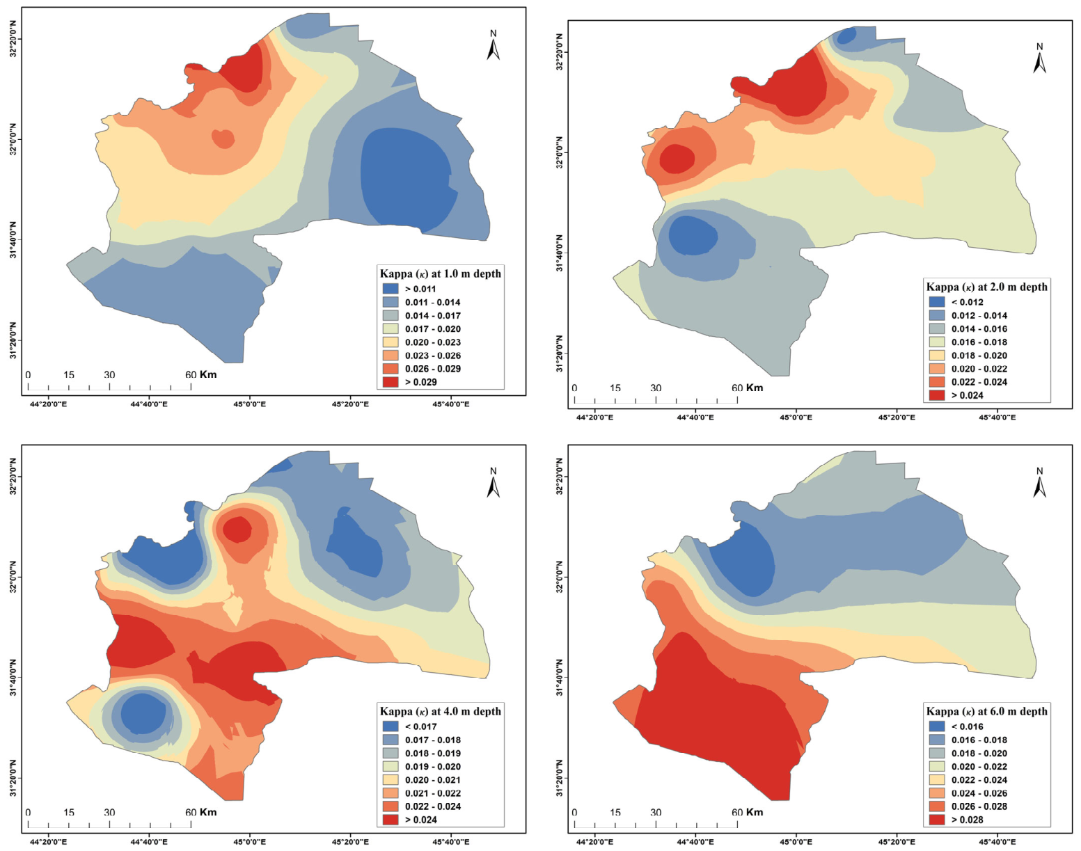
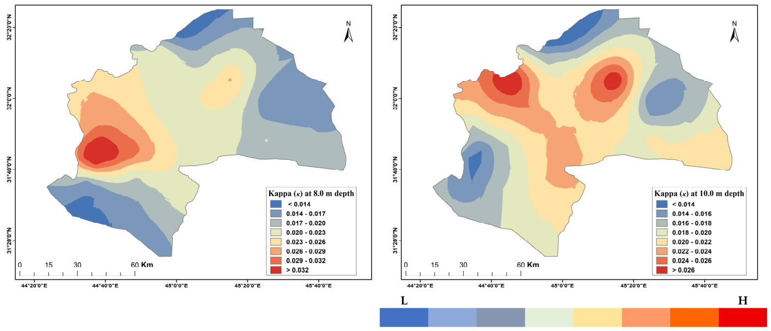
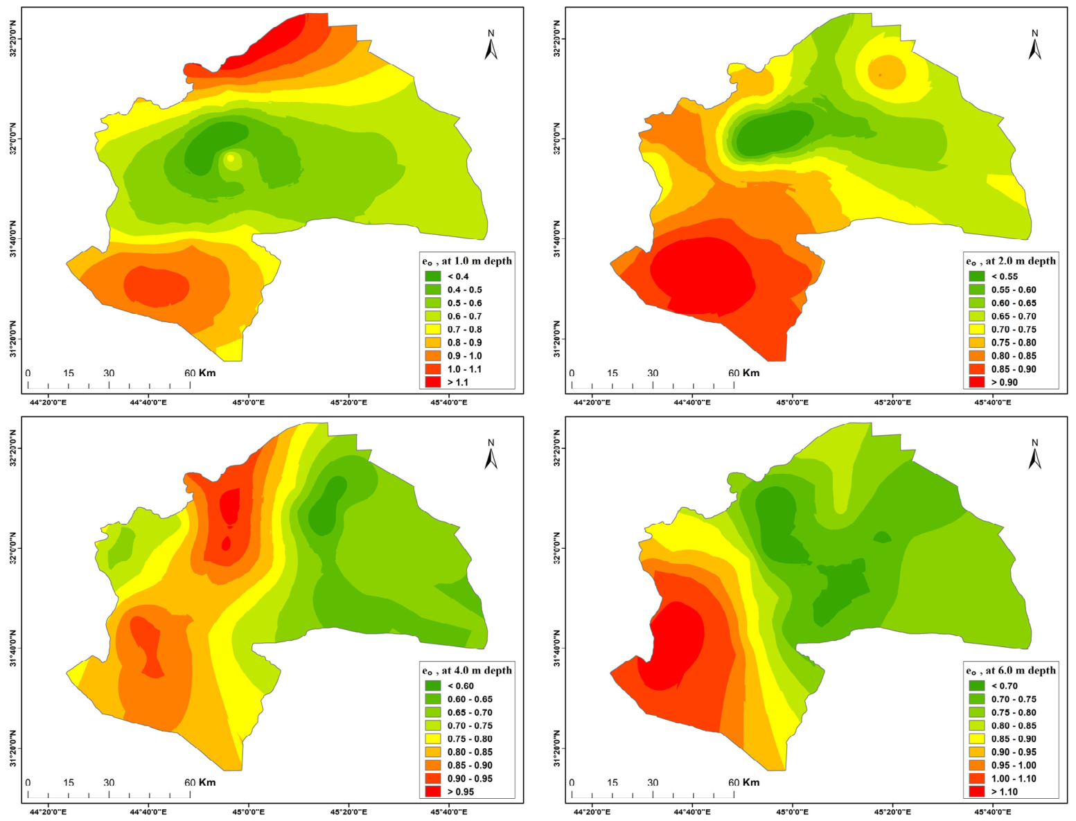
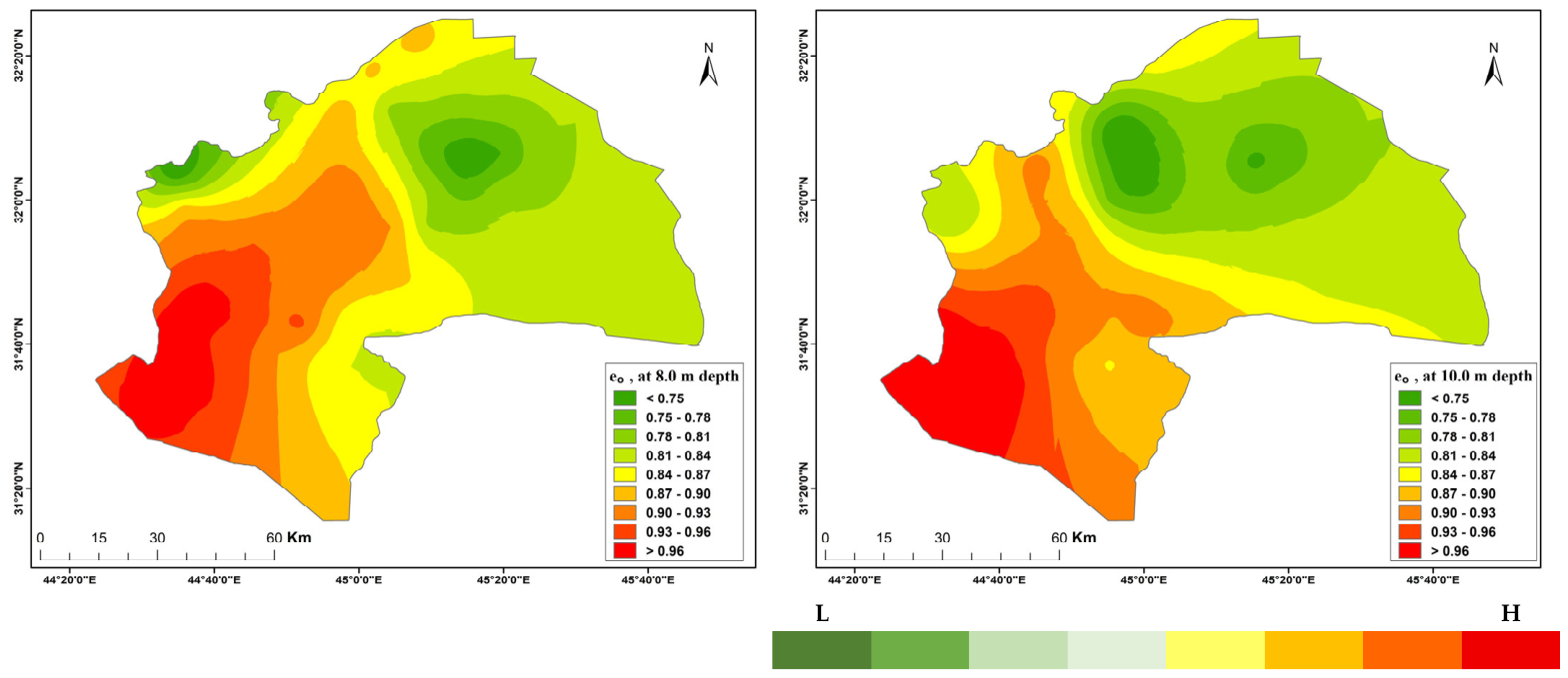
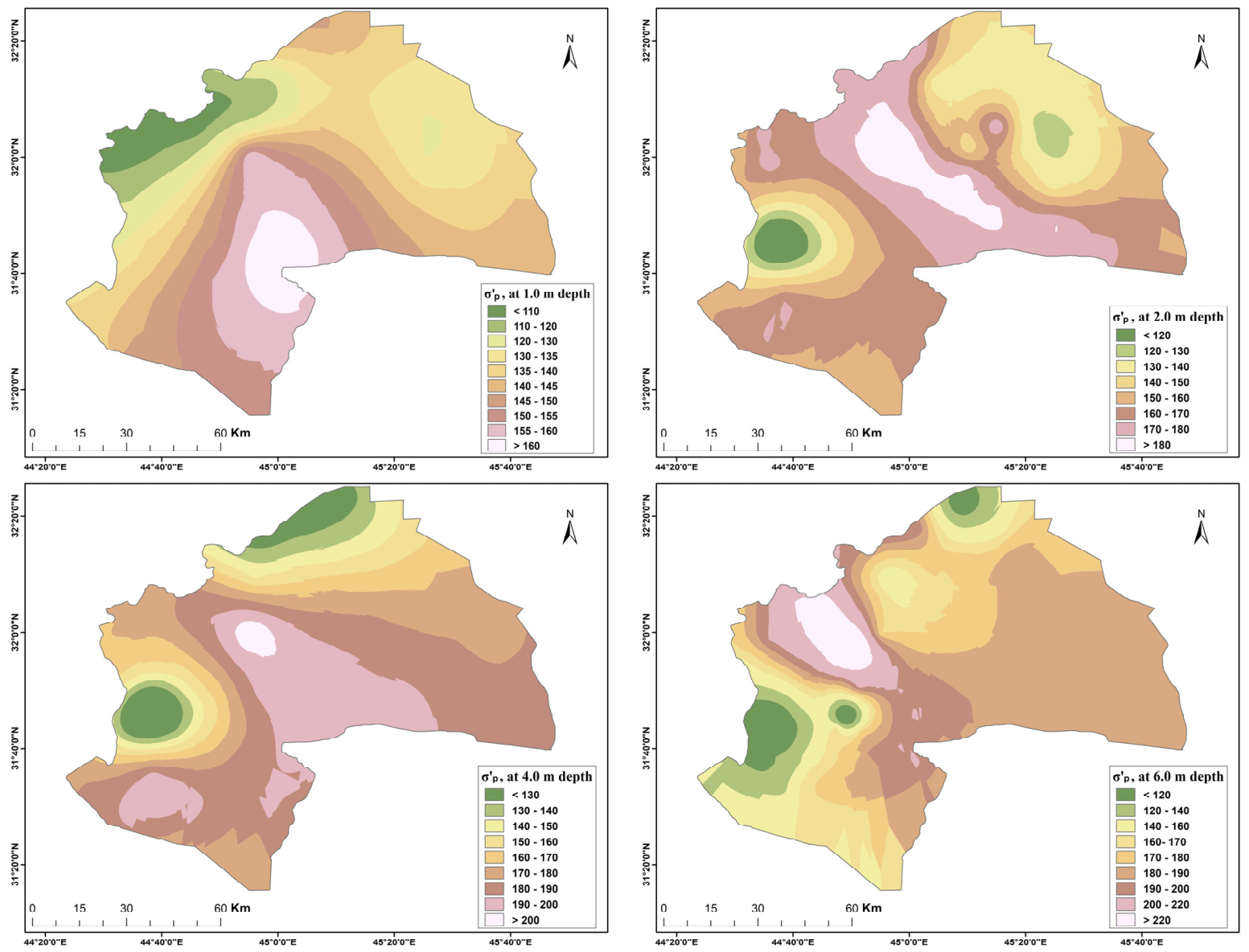
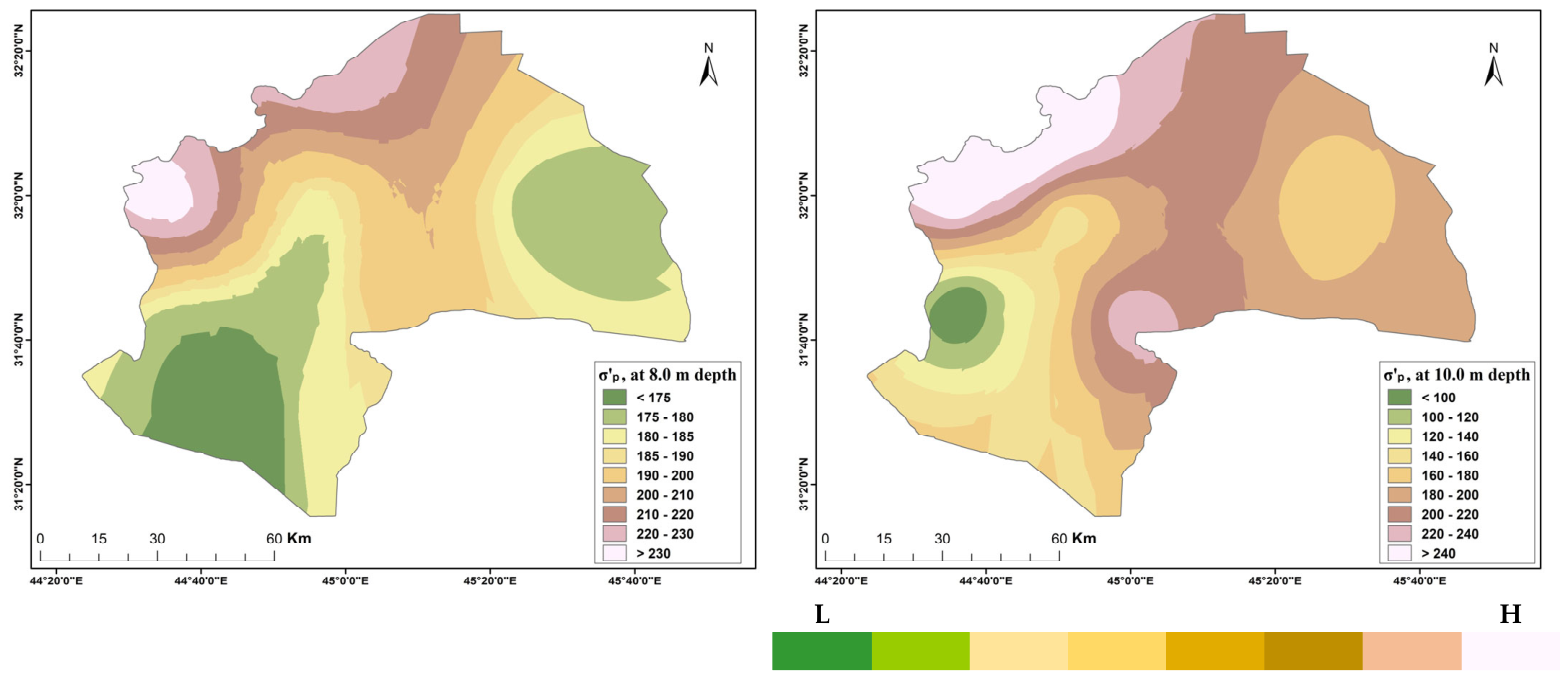
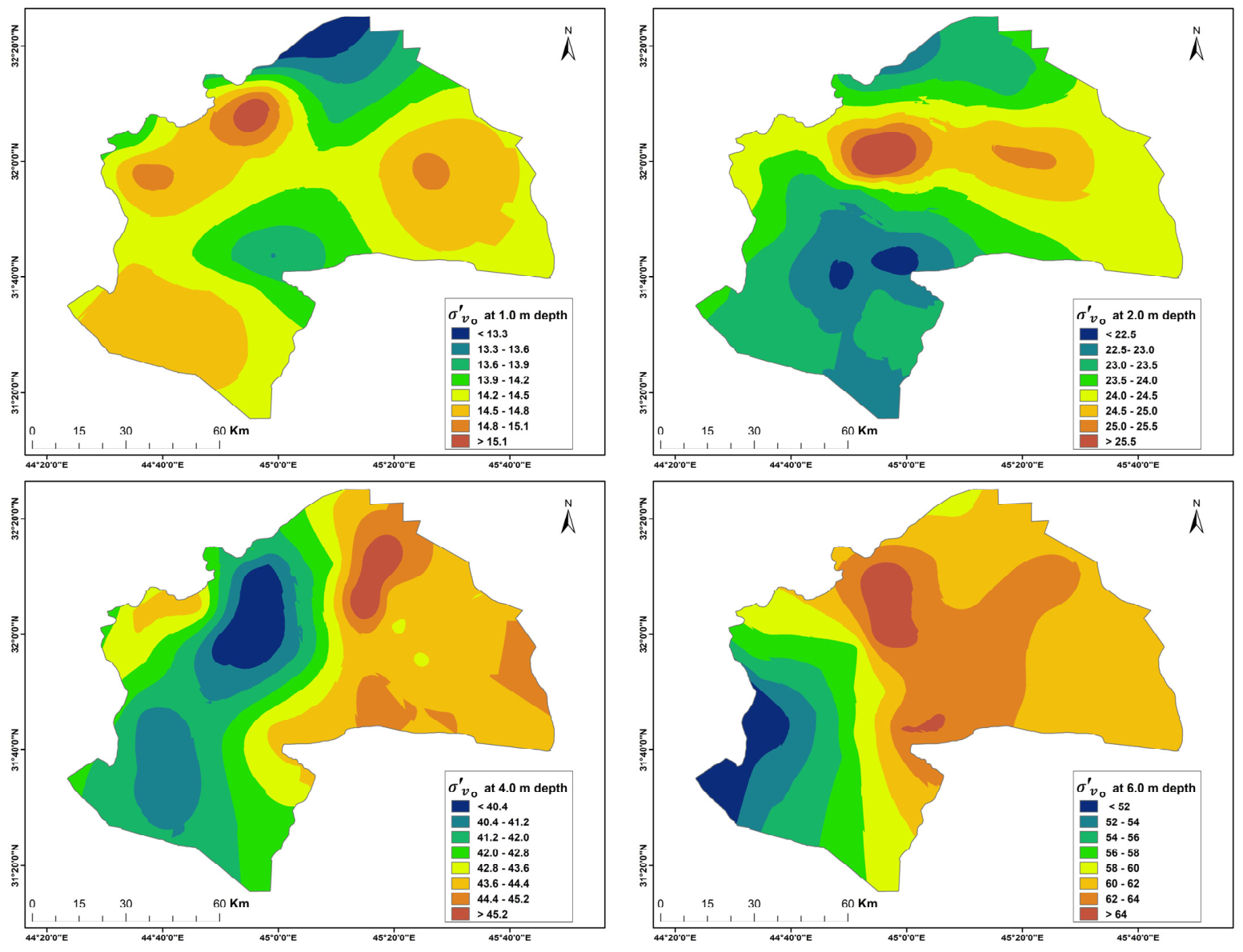
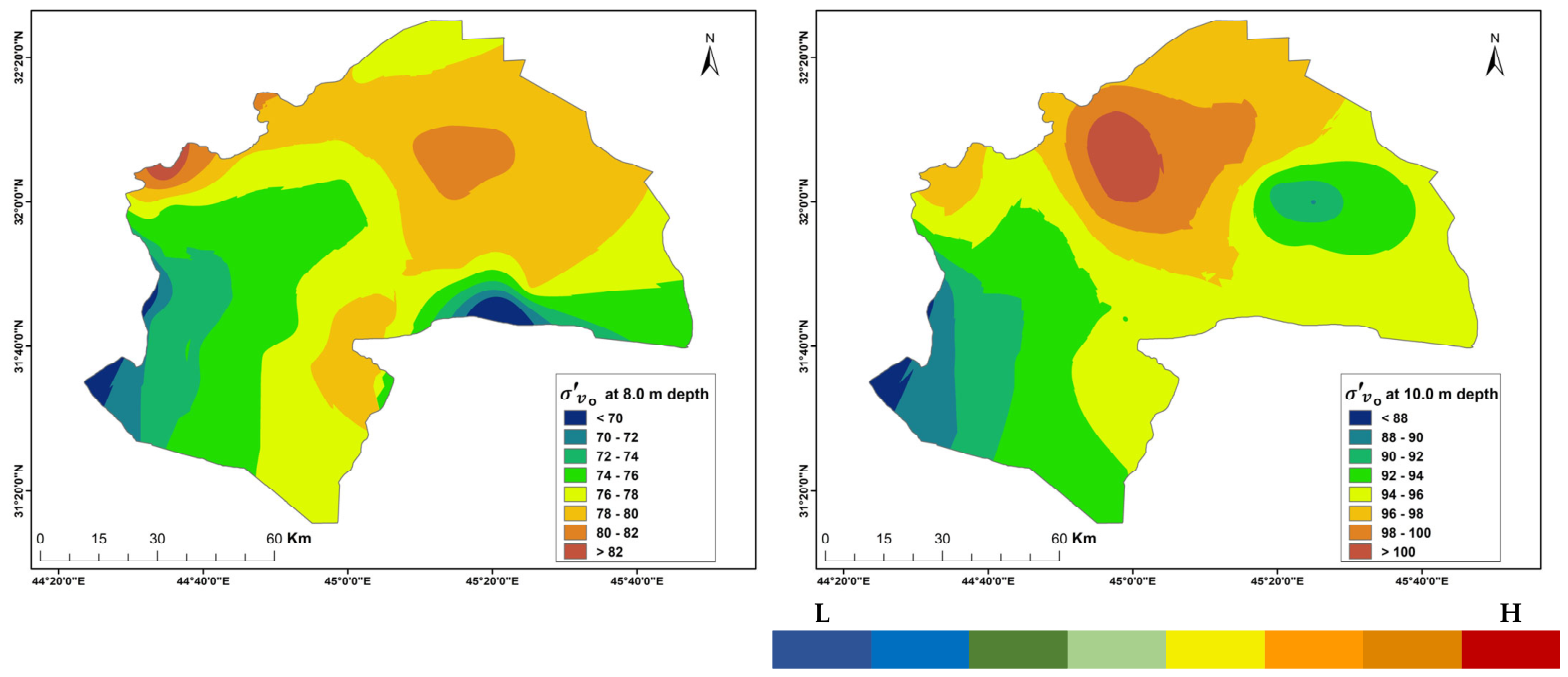
In addition to their vertical variation, the derived constitutive parameters exhibit clear spatial variability across the study area. Because the analytical dataset is based on regionally distributed boreholes, GIS-based mapping was used to examine the horizontal distribution of the key parameters at each standard depth. This step is important because FE material assignment and location-informed parameter selection depend not only on average parameter values but also on whether those values show coherent regional organisation. The GIS-based distributions indicate that the derived parameter fields are not spatially uniform. The mapped values of λ show that virgin compressibility varies laterally across the study area, with distinct zones of comparatively higher and lower values identifiable at several depths. This pattern suggests that the more compressible response of the clay sequence is spatially structured rather than randomly scattered, which is directly relevant to settlement prediction and constitutive parameter assignment in numerical modelling. Similarly, the mapped distribution of reveals regional contrasts in yield stress and consolidation history, indicating that laterally variable stress history must be considered in addition to depth-dependent change.
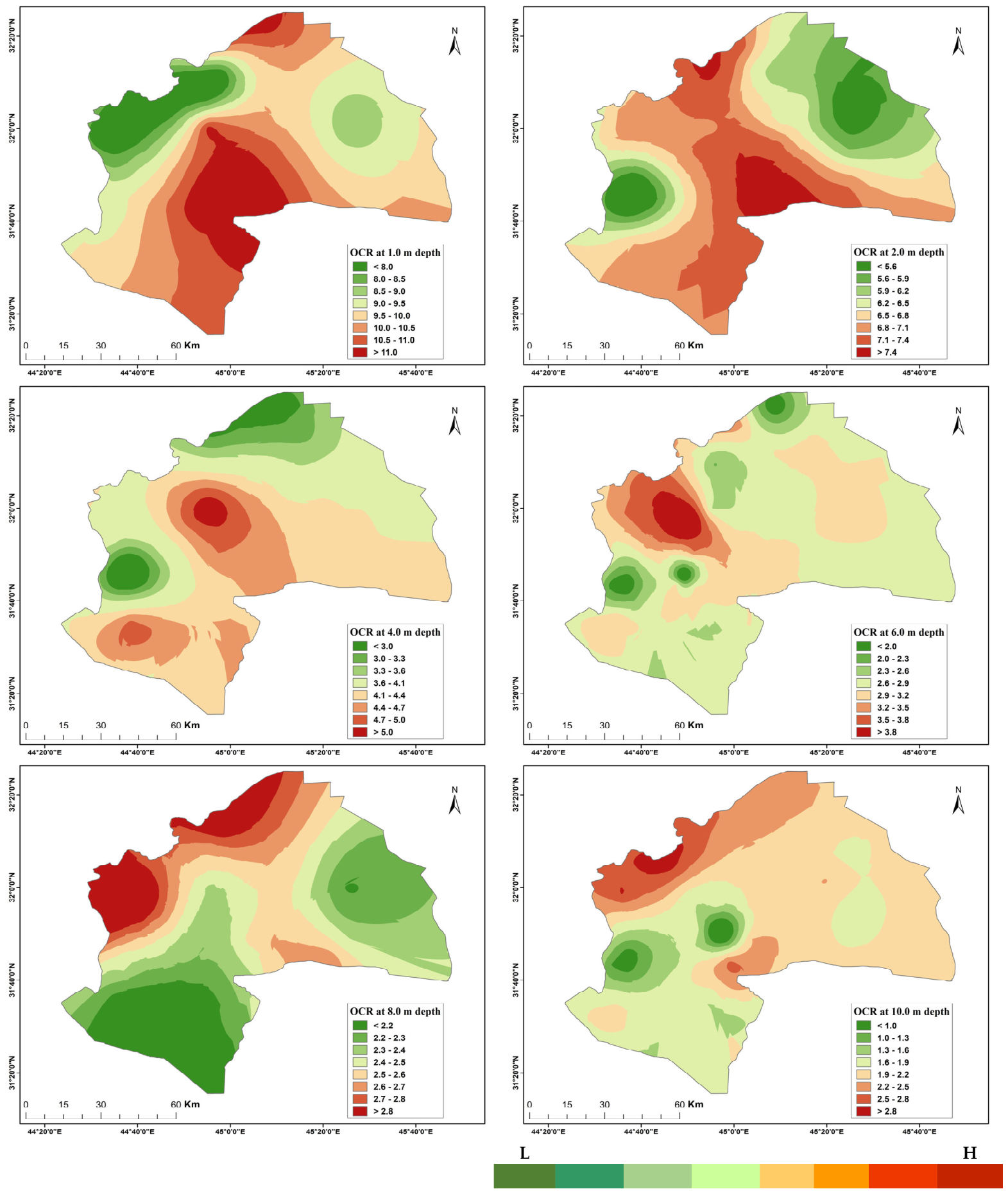
The groundwater-corrected OCR maps provide one of the clearest mechanical indicators of regional variation. Because OCR reflects the combined effect of preconsolidation pressure and present effective stress, its spatial distribution provides a direct indication of the stress history of the shallow clay sequence. The mapped results show that the degree of overconsolidation varies laterally as well as vertically, with some sectors remaining more strongly overconsolidated than others at comparable depths. This finding supports the use of regionally differentiated representative parameter assignment rather than a single profile averaged over the entire study area. The spatial distribution of
further confirms that the density and state of the deposit are laterally variable. Zones of relatively higher void ratio can be identified at multiple depths, indicating that the soil structure is not spatially homogeneous across the region. When considered together with the λ maps, these
patterns help distinguish areas that are both looser and more compressible from those that are comparatively denser and less deformable. In this way, the GIS-based outputs strengthen the interpretation of the regional constitutive framework by linking soil state and stress history to specific spatial domains. Beyond supporting interpretation of regional variability, the GIS-based parameter maps also provide a practical engineering output. Because the spatial distributions were generated separately for each standard depth, they can be used to identify representative values of λ,
, OCR, and
corresponding to specific locations within the study area. The mapped outputs therefore function not only as visualisation tools, but also as a location-based reference framework for preliminary design, regional assessment, and constitutive parameter selection in subsequent modelling studies. Taken together, the GIS-based parameter maps demonstrate that the constitutive behaviour of the investigated soils is controlled by both depth and location. This finding is central to the interpretation developed in the present study because it shows that the final material grouping and FE assignment framework must account for horizontal spatial structure as well as vertical stratification. The leave-one-out cross-validation results indicate that the Ordinary Kriging interpolation provides acceptable regional predictive performance for the derived MCC parameter fields. The mean errors are close to zero for all parameters, indicating limited systematic bias. The normalised RMSE values are generally below about 12%, with the lowest relative error obtained for the groundwater-corrected initial effective stress. These results support the use of the GIS maps as regional-scale spatial interpretation tools for research analysis, urban-scale geotechnical assessment, preliminary FE parameter selection, and sensitivity analysis. However, the maps should still be interpreted cautiously near the margins of the borehole network and in areas with lower local station density. The corresponding leave-one-out cross-validation indicators are summarised in
Table 4.
The kriging-based maps should be interpreted together with the associated interpolation uncertainty, particularly near the margins of the borehole network and in areas with lower local data density. Representative depth-specific GIS maps for selected MCC parameters are presented in this section to illustrate the spatial interpretation procedure (
Figure 5 and
Figure 6). The complete depth-specific map series for all derived MCC parameters is provided in
Appendix A to support detailed spatial interpretation and location-informed parameter selection.
4.4. FE Material Library for Modelling
Based on the processed MCC parameter dataset, a finite element material library was developed to provide representative constitutive parameter sets for use in numerical modelling. Representative summary statistics were extracted for λ, κ,
, OCR,
, and
and median values were adopted as the principal modelling inputs, as summarised in
Table 5 and
Table 6. Lower and upper bound values were retained to support sensitivity studies and uncertainty-aware parameter selection. The resulting material library was organised in two complementary forms. The first is an overall library, which provides representative parameter sets suitable for preliminary modelling and regional assessment. The second is a depth-specific library, in which the representative values are reported separately for each standard depth horizon to preserve the observed vertical variation in compressibility and stress history. This dual structure increases the practical value of the dataset by allowing the user to select either a simplified regional representation or a more refined depth-dependent parameter assignment according to the requirements of the analysis. From a modelling perspective, the material library represents the final transformation of the processed site investigation archive into FE-ready constitutive inputs. Rather than remaining as isolated geotechnical records or descriptive summaries, the data are converted into a structured parameter resource that can be applied directly in settlement, excavation, and foundation analyses. The library also provides a rational basis for bounded parameter selection, which is especially useful in regional or preliminary stage simulations where uncertainty must be acknowledged. The representative FE material library is summarised in
Table 5, while the depth-specific FE material library is presented in
Table 6. Together, these tables provide a practical basis for constitutive parameter assignment in finite element modelling of shallow clayey deposits.
Table 5 presents the representative FE material library derived from the groundwater-corrected MCC parameter dataset. Clear contrasts are evident among the grouped material classes. The soft compressible clay class is characterised by relatively high κ and high
, indicating greater deformability and a softer soil state. By contrast, the stiff and dense highly overconsolidated clay classes exhibit the highest OCR values, confirming their stronger stress history effects, with the dense highly overconsolidated class also showing the lowest
and therefore the densest material state. The high
compressible clay class combines the highest λ and the highest median preconsolidation pressure, indicating a mechanically important class of compressible soils with elevated yield stress. These differences confirm that the regional clay sequence cannot be represented adequately by a single constitutive parameter set and that grouped FE material assignment is warranted.
Table 6 provides the depth-specific FE material library derived from the groundwater-corrected MCC parameter dataset. The results show that the representative constitutive parameters vary markedly with depth. At 1 and 2 m, the profile is dominated by strongly overconsolidated material classes, with OCR values generally exceeding 6.5. From 4 m downward, more compressible classes become increasingly important, while OCR decreases progressively and λ generally increases. The table therefore confirms that both the representative material classes and their associated parameter values are depth-dependent, supporting the use of horizon-specific FE material assignment where vertical variation is important to the analysis.
4.5. Summary of Principal Findings
The results demonstrate that archived site investigation data can be converted into a complete groundwater-corrected constitutive parameter dataset through systematic data cleaning, treatment of missing values, and constitutive parameter derivation. Mechanically, the results indicate a transition from highly overconsolidated and relatively stiff shallow clay to deeper clay layers with higher void ratio, higher virgin compressibility, and lower resistance to virgin compression under new loading. The derived parameters show clear variation with depth, particularly in λ, , and OCR, confirming that the shallow clay sequence is mechanically nonuniform. GIS-based mapping further shows that these parameters are also laterally variable and form spatially coherent regional patterns rather than isolated random fluctuations. This depth-dependent and spatially structured behaviour provides a strong basis for representative FE parameter assignment. The processed constitutive parameter dataset was successfully translated into practical FE material libraries, both in representative overall form and in depth-specific form, for direct use in geotechnical modelling. The final outputs therefore establish a direct link between routine site investigation data and FE-ready constitutive inputs for settlement, excavation, and foundation analysis of shallow clayey soils.
5. Discussion
5.1. Interpretation of Compressibility and Stress History
The results indicate that the shallow clay sequence is mechanically heterogeneous in terms of both compressibility and stress history. This heterogeneity is expressed first through the depth-wise variation in the derived constitutive parameters and second through their spatial organisation across the study area, as shown by the GIS-based maps. Taken together, these patterns demonstrate that the investigated deposits cannot be represented adequately by a single constitutive description, even within the relatively limited depth range considered in this study. The increase in λ with depth indicates that the deeper horizons tend to exhibit greater virgin compressibility than the near-surface soils. When considered together with the increase in , this suggests that the deeper deposits are generally in a looser and more compressible state, whereas the shallowest layers are relatively denser or more structured. From a constitutive perspective, this finding is important because λ controls the slope of the virgin compression line and therefore influences predicted volumetric strain under new loading. A depth-dependent increase in λ implies that the settlement response may become more pronounced in deeper horizons, even where the soil remains overconsolidated.
Correspondingly, the OCR profile shows a strong reduction in stress-history effects with depth. The near-surface layers are markedly overconsolidated, while the deeper horizons remain overconsolidated but to a lesser degree. This pattern is mechanically reasonable for shallow clayey deposits that may have experienced desiccation, seasonal moisture variation, surface unloading, or other forms of historical stress changes near the ground surface. In numerical modelling terms, the implication is that the upper part of the profile is likely to exhibit greater resistance to plastic compression at low to moderate loading levels, whereas the deeper soils may transition more readily toward virgin compression under increasing effective stress. The combined variation of λ, , , and OCR therefore defines a constitutive profile in which shallower soils are stiffer in stress history terms, while deeper soils are more compressible in state and compression behaviour. The GIS-based parameter distributions further show that these characteristics are not only depth-dependent but also laterally variable across the study area. This is a critical result because it confirms that the constitutive response of the deposit cannot be captured adequately by descriptive soil classification alone or by a single regional average parameter set. In this sense, the derived parameter patterns support MCC based finite element material assignment when the input parameters are derived, corrected, and organised in a consistent manner, provided that the input parameters are derived, corrected, and organised in a consistent manner.
5.2. Significance of Groundwater-Corrected OCR
One of the most important methodological outcomes of the present study is the demonstration that groundwater correction materially affects the constitutive interpretation of the regional dataset. Because the groundwater table in the study area lies within about 1.0 to 1.4 m of the ground surface, much of the investigated profile is below or close to the saturated zone. Under such conditions, the use of dry overburden stress alone would overestimate the initial effective vertical stress, particularly at the deeper horizons, and would therefore underestimate OCR. The groundwater-corrected stress calculations produced a more defensible OCR profile by accounting for the reduced effective unit weight below the groundwater table. This is a significant numerical adjustment. In MCC, OCR governs the location of the current stress state relative to the yield surface and therefore directly affects whether the soil responds primarily in recompression or approaches virgin yielding under loading. A systematic underestimation of OCR would lead to constitutive assignments that are artificially closer to normal consolidation, which could bias settlement predictions and distort the evaluation of stiffness degradation and plastic strain development.
The importance of this correction is especially clear when the results are interpreted spatially. Because OCR is a function of both preconsolidation pressure, , and present effective stress, its GIS-based distribution reflects not only inherited stress history but also the physically realistic overburden state of the deposit. The resulting OCR maps, therefore, provide a much stronger basis for regional constitutive interpretation than would have been obtained from uncorrected dry stress estimates. Accordingly, groundwater correction is not simply an improvement in parameter calculation. It is a necessary step for transforming archived site investigation data into meaningful constitutive inputs for FE analysis. A further practical advantage is that this correction strategy can be implemented at a regional scale even when complete piezometric profiles are unavailable, provided that groundwater depth can be assigned from available field records within a defensible local range. This makes the workflow especially useful for regional borehole archives, where site investigation data may be incomplete, but groundwater conditions can still be incorporated in a physically meaningful way. The corrected OCR field therefore serves not only as a constitutive state variable but also as a key bridge between routine geotechnical records, regional interpretation, and FE- ready parameterisation.
5.3. Engineering Value of the GIS-Supported Spatial Analysis
The GIS-based mapping of λ, κ, , OCR, and substantially strengthens the engineering interpretation of the derived dataset. Without the spatial maps, the results would still demonstrate clear vertical variability, but they would provide less evidence that the constitutive properties are regionally organised. The GIS outputs show that the key parameters are distributed in coherent spatial patterns rather than as isolated or random values. This is important because FE parameter assignment at a regional scale is inherently spatial, not only vertical. The mapped distributions of λ show that compressibility varies laterally across the study area and that zones of higher virgin compression tendency can persist across multiple depths. Similarly, the and OCR maps indicate that stress history is not laterally uniform, even where depth is similar. The maps further show that the state of the deposit changes regionally, supporting the interpretation that constitutive behaviour must be understood in terms of both soil state and loading history. Collectively, these spatial patterns provide a more complete picture of the subsurface than a depth summary table alone.
From a geotechnical perspective, the GIS-supported results justify the use of spatially informed parameter selection rather than simple lateral averaging. If one part of the study area is characterised by higher λ and , while another shows higher OCR and lower void ratio, then a single regional parameter set would blur mechanically important contrasts. By contrast, the GIS-based outputs preserve those contrasts and allow them to be incorporated into modelling decisions in a traceable manner. This is also where the present study becomes distinct from purely descriptive geotechnical mapping. The maps are not presented merely to show the geographical distribution of variables. Their function is to support constitutive interpretation, FE material selection, and location-specific retrieval of representative parameter values. In this sense, GIS is used here as an analytical bridge between borehole data and FE modelling, rather than as an end in itself.
5.4. Value of the Parameter Grouping Framework for FE Modelling
The parameter grouping framework developed in this study provides a practical means of translating regional geotechnical variability into FE-ready material classes. Rather than assigning a unique material model to each individual record, the workflow organises the derived MCC parameter space into a manageable set of mechanically interpretable classes. This provides a more robust basis for FE modelling than classification by soil description alone, since materials described simply as clay may still differ markedly in OCR, , λ, and , and therefore in predicted constitutive response. From a modelling perspective, this grouping approach supports flexible parameter assignment. For preliminary regional analyses, the overall material library provides a concise representation of the dominant constitutive behaviour, whereas the depth-specific library preserves vertical variation where greater refinement is required. Because the classes are defined through explicit engineering logic rather than opaque clustering, the resulting material groupings remain transparent, interpretable, and easier to justify in practical modelling applications.
5.5. Practical Applicability of the FE Material Library
The FE material library developed in this study is one of the principal practical outputs of the work. Its importance lies in the conversion of a heterogeneous archive of site investigation records into a format that can be used directly in constitutive modelling. The library provides representative values of λ, κ, , OCR, , and by material grouping and by depth, thereby creating a direct route from processed geotechnical data to numerical model input. For practical modelling, the median values provide a stable basis for baseline simulations, while the P10 and P90 bounds define a rational range for sensitivity analysis. This is particularly useful in preliminary design and regional screening applications, where the objective is not to calibrate a single site with maximum precision but to represent the likely constitutive behaviour of a broader area in a structured and defensible manner. The material library therefore supports both deterministic modelling and bounded evaluation of uncertainty.
Another important feature of the library is that it preserves the distinction between general constitutive behaviour and depth-dependent variation. In some cases, a modeller may require only one representative parameter set for each material grouping. In other cases, depth-specific assignment may be necessary to reproduce the vertical evolution of compressibility and OCR. By providing both formats, the present study increases the practical adaptability of the output and makes it useful across a wide range of engineering applications. The library should not be interpreted as a substitute for project-specific testing, where detailed design decisions depend on highly site-specific constitutive behaviour. The regional scale of the study should also be considered when applying the proposed material library. The investigated area covers a large geographical domain, and the GIS-based maps represent regional trends in the derived MCC parameters rather than point-specific soil properties at the scale of an individual structure or foundation footprint. Local variability may occur within distances smaller than the borehole spacing and therefore cannot be fully resolved by the regional interpolation. Accordingly, the proposed FE material library is most appropriate for research-based case-study analysis, regional geotechnical interpretation, urban planning and preliminary urban design, regional screening, comparison among candidate locations, sensitivity analysis, and early-stage FE parameter selection. For structure-specific soil–structure interaction analysis or final design, the regional parameter values should be used only as initial estimates and should be supplemented by local boreholes, high-quality laboratory testing, and project-specific calibration. Rather, its strength lies in providing a scientifically organised starting point for FE analysis in contexts where routine site investigation data are available but advanced constitutive calibration is not. When used together with the GIS-based parameter maps, the library also enables location-informed selection of representative parameter values, thereby strengthening its practical value for regional assessment and preliminary modelling. In this sense, the study contributes both a practical regional modelling resource and a transferable methodology for converting routine geotechnical archives into finite element-ready constitutive inputs.
5.6. Limitations and Future Development
Several limitations should be acknowledged. First, the final constitutive dataset was developed from a regional archive containing incomplete and heterogeneous site investigation records, and some parameters therefore required structured estimation or imputation. Although this treatment was applied systematically and under engineering control, the resulting dataset should still be interpreted as a regionally derived constitutive resource rather than as an exact substitute for comprehensive, advanced laboratory characterisation at every location. This limitation does not reduce the practical value of the workflow, but it defines the scale at which the results should be used and interpreted. A specific limitation of using routine borehole data for MCC parameterisation is that such records do not provide the same level of constitutive control as advanced laboratory testing. High-quality oedometer and triaxial tests can define compression behaviour, swelling response, yield stress, stress-path dependency, drainage conditions, and stiffness degradation under controlled boundary conditions. By contrast, routine borehole archives often contain index properties, basic consolidation indicators, unit weight data, SPT records, and partial oedometer information collected under different project requirements and reporting standards. The MCC parameters derived in this study should therefore be interpreted as regional engineering estimates suitable for preliminary FE modelling, spatial comparison, and bounded sensitivity analysis, rather than as fully calibrated site-specific constitutive parameters. For detailed design applications, particularly where serviceability or safety is highly sensitive to settlement prediction, the proposed material library should be supplemented by project-specific high-quality consolidation and triaxial testing and calibrated against observed field or laboratory behaviour.
Second, λ was derived partly from empirical estimation where direct compression- index data were unavailable. This approach is acceptable for the regional objective of the present study and is consistent with the use of routine investigation data for constitutive parameterisation. However, it introduces an additional level of uncertainty, which should be recognised where highly refined, project-specific modelling is required. Third, although groundwater correction was incorporated using the groundwater level assigned to each location, the available data still represent a shallow regional groundwater regime rather than a fully resolved transient piezometric profile. This is appropriate for the scale and purpose of the present study, but local design applications may require more detailed hydraulic characterisation.
A further consideration concerns the depth-specific FE material library, in which the number of records varies among material class and depth combinations. At the regional scale, however, the dataset provides broad coverage of the study area and captures the principal patterns of compressibility and stress history within the shallow clay sequence. Some class depth combinations are supported by fewer records than others, but this variation does not affect the overall value of the regional library for the purposes of preliminary modelling and regional interpretation. More broadly, the present study focuses on shallow clayey soils within a specific regional geotechnical setting and should therefore not be generalised directly to other soil types or geological environments without recalibration of the parameter derivation framework. Future development should include validation of the proposed material library through direct FE case studies and comparison against observed field performance. Additional refinement could be achieved through integration of higher-quality consolidation and triaxial data and explicit calibration of constitutive parameters beyond the core MCC compression and stress history variables. The GIS-based parameter maps developed in this study already provide regionally representative spatial coverage and support location-informed selection of representative constitutive values. Future work may strengthen their utility through higher resolution updating, incorporation of additional site investigation data, and separate development of the parameter grouping and constitutive zoning framework, where the spatial classification and GIS-based zone mapping can be examined in greater detail. Such developments would extend the present framework from regional constitutive characterisation to project-specific calibration and more integrated digital geotechnical modelling.
5.7. Broader Contribution of the Study
The broader contribution of this study lies in demonstrating a complete and transparent pathway from archived site investigation data to FE-ready constitutive modelling inputs. The value of the study is not limited to the specific case study area. Similar regional geotechnical archives exist in many parts of the world, yet they remain underused because they are incomplete, inconsistent, or not organised for constitutive analysis. The framework proposed here shows that such archives can be processed in a scientifically structured manner to derive meaningful constitutive input parameters, incorporate groundwater-corrected stress history, and generate both modelling-oriented material libraries and GIS-based parameter outputs.
This contribution is relevant to both research and practice. For researchers, the study provides a framework for linking geotechnical databases, constitutive interpretation, spatial analysis, and numerical modelling within a unified workflow. For practitioners, it offers a practical route for converting routine investigation records into representative parameter sets that can support FE analysis at a regional or preliminary project scale. In both cases, the key contribution is methodological integration. The present study brings together data preparation, missing value treatment, constitutive parameter derivation, groundwater correction, GIS-supported spatial interpretation, and modelling output development within a single coherent framework. In this way, the study demonstrates that routine regional geotechnical archives can be transformed into scientifically defensible and practically usable constitutive resources for spatial interpretation and finite element modelling.
6. Conclusions
This study developed and demonstrated a transparent methodology for deriving finite element-ready constitutive input parameters from regional borehole data for shallow clayey soils. The workflow integrates data cleaning, treatment of missing values, constitutive parameter derivation, groundwater-corrected effective stress evaluation, GIS-based spatial interpretation, and practical FE material library development within a single coherent framework. The results show that routine geotechnical archives can be transformed into a defensible constitutive dataset even where the available records are incomplete and heterogeneous. The derived parameters revealed clear vertical variation, particularly in λ, , and OCR, confirming that the shallow clay sequence is mechanically nonuniform with depth. GIS-based mapping further demonstrated that the key constitutive parameters also vary laterally and form coherent spatial patterns across the study area. These findings show that the constitutive behaviour of the investigated soils is controlled by both depth and location and cannot be represented adequately by a single regional parameter set.
The groundwater-corrected stress evaluation proved to be a critical component of the workflow because it materially influenced the estimation of and OCR and therefore strengthened the constitutive interpretation of the regional dataset. On this basis, the processed constitutive parameter space was translated into representative FE material libraries in both overall and depth-specific form. These outputs provide a practical basis for constitutive parameter assignment in settlement, excavation, and foundation analyses, while the GIS-based parameter maps support location-informed selection of representative values across the study area. The broader contribution of the study lies in demonstrating that archived regional borehole data can be converted into scientifically structured and practically useful constitutive resources for geotechnical modelling. Because the outputs are derived at a regional scale, they are intended for research-based case-study analysis, urban-scale geotechnical interpretation, preliminary FE parameter selection, and regional planning support, while local design applications require site-specific investigation and calibration. The proposed methodology therefore offers a transferable route from conventional site investigation archives to groundwater-corrected constitutive parameterisation and FE-ready material assignments for regional geotechnical modelling of shallow clayey soils.