Article

Advancing Geohazard Assessment in Heritage Areas Through Fuzzy Logic

by
George Faidon D. Papakonstantinou
School of Rural Surveying and Geoinformatics Engineering, National Technical University of Athens (NTUA), 15780 Athens, Greece
Geographies 2026, 6(2), 48; https://doi.org/10.3390/geographies6020048
Submission received: 20 March 2026 / Revised: 6 May 2026 / Accepted: 9 May 2026 / Published: 11 May 2026

Abstract

Preventive geohazard assessment in heritage landscapes presents a methodological challenge, as environmental processes rarely operate within clearly bounded states. Instead, they evolve gradually across space and time and are often only partially observable. Conventional cumulative indices based on linear aggregation and fixed classification thresholds provide operational clarity but may suppress gradual activation, interaction effects, and uncertainty that are critical for preventive heritage management. This study develops a fuzzy geohazard assessment approach that extends cumulative hazard modeling through graded representation and uncertainty-aware aggregation. Environmental variables are represented as spatial fuzzy sets, allowing hazard conditions to be expressed as degrees of activation rather than discrete classes. Hazard-specific activation is derived through rule-based fuzzy inference, while cumulative geohazard conditions are synthesized using a weighted fuzzy γ aggregation operator that balances conjunctive behavior with precautionary disjunctive amplification. The approach is implemented within a Geographic Information System (GIS) environment and demonstrated in Parrhasian Heritage Park, a mountainous heritage landscape in Southern Greece. Results show that cumulative geohazard patterns respond systematically to variations in the precautionary parameter γ, enhancing transitional zones where multiple hazards coexist at moderate activation levels while preserving spatial continuity. Sensitivity analysis indicates that cumulative activation patterns remain structurally stable under moderate variations in membership calibration, supporting preventive GIS-based decision making.

1. Introduction

Heritage areas constitute highly sensitive socioecological systems in which cultural and natural assets of exceptional value coexist with dynamic geomorphological and environmental processes [1]. In such environments, geohazards may lead to irreversible impacts on the physical integrity and long-term conservation of heritage assets. This necessitates preventive and spatially sensitive assessment approaches rather than event-based evaluation [2].
Under conditions of increasing climatic variability, geohazards in heritage areas rarely manifest as isolated catastrophic events. Instead, they emerge through gradual activation and cumulative interaction among geomorphological and environmental processes. Moderate but persistent phenomena, such as slope weakening, surface erosion, or hydrological stress, may progressively alter landscape stability without producing clearly identifiable hazard events. These dynamics challenge conventional approaches based on discrete thresholds or event-driven characterization [3,4].
Within this perspective, the Geohazard Prevention Index (GPI) introduced a cumulative, prevention-oriented framework supporting early-stage spatial screening in heritage landscapes [5,6,7,8].
The present study builds upon this foundation by developing a fuzzy geohazard assessment approach designed to represent gradual activation, process interaction, and environmental uncertainty within cumulative geohazard modeling. In contrast to conventional indices based on crisp classification and linear aggregation, the proposed approach expresses environmental controls and hazard activation as degrees of membership using fuzzy set theory. Hazard activation is derived through rule-based fuzzy inference, while cumulative conditions are synthesized through a weighted fuzzy γ aggregation operator that explicitly controls the balance between conjunctive behavior and precautionary disjunctive amplification. In this way, the approach operationalizes a precautionary interpretation of geohazard conditions within cumulative spatial assessment.
Although fuzzy logic has been widely applied in geohazard susceptibility mapping and environmental decision support, its use has primarily focused on classification flexibility or predictive performance. The integration of fuzzy representation within cumulative preventive geohazard assessment in heritage landscapes has received considerably less attention [9,10,11,12]. The contribution of this study is therefore not to replace cumulative indices but to refine their internal representational structure in order to better represent these processes. This refinement enhances the interpretability of cumulative geohazard conditions within spatially heterogeneous heritage landscapes.
This study extends the Geohazard Prevention Index framework by integrating fuzzy set representation and precautionary γ aggregation into cumulative geohazard assessment. The objective is to develop and demonstrate an approach that enhances the assessment of cumulative geohazard conditions in heritage landscapes.
The paper is structured as follows. Section 2 discusses conceptual and methodological considerations associated with conventional geohazard assessment. Section 3 revisits the Geohazard Prevention Index and outlines the rationale for its evolution. Section 4 presents the design principles of the fuzzy approach. Section 5 formalizes the methodology. Section 6 demonstrates the spatial application. Section 7 discusses implications for heritage management, and Section 8 concludes with perspectives for future research.

2. Conceptual and Representational Challenges in Geohazard Assessment

2.1. Methodological Considerations

Conventional geohazard assessment approaches have been successfully applied to support spatial screening, prioritization, and comparative evaluation across diverse environmental contexts. Their methodological structure, often based on linear aggregation and threshold-based classification, provides transparency and interpretability essential for applied assessment. These characteristics have contributed to the broad adoption of cumulative indices, including the Geohazard Prevention Index, particularly in data-limited settings [13,14].
At the same time, the representation of environmental processes through crisp variables and proportional aggregation reflects an implicit but necessary simplification of complex system behavior. Linear aggregation assumes that the contributions of individual factors can be proportionally combined into a cumulative measure [5,15,16]. In many applications, this assumption produces robust and informative results. However, its reliance on proportional aggregation may limit sensitivity to gradual process emergence and interaction.
In heritage areas, geohazard expression often emerges from the spatial convergence and persistence of multiple moderate processes rather than from the dominance of a single extreme factor. In such contexts, the limitation lies not in the cumulative logic itself but rather in the rigidity of discrete categorical representations when applied to inherently continuous phenomena [17,18]. Discrete classes represent environmental conditions through fixed thresholds (e.g., low, moderate, and high), implying abrupt transitions between states. In contrast, activation degree expresses the extent to which conditions contribute to geohazard activation as a continuous membership value μ(x) ∈ [0, 1], allowing gradual transitions and partial participation across states.
Uncertainty constitutes an additional dimension of this representational challenge. Within this perspective, approaches capable of representing gradual transitions and partial membership may provide a more flexible basis for expressing environmental uncertainty in cumulative geohazard assessment [19,20].
Uncertainty in geohazard assessment is often addressed through probabilistic frameworks, where it is expressed in terms of event likelihoods or conditional probabilities. Such approaches are suitable for modeling well-defined hazard events with sufficient data. In contrast, the present study focuses on representing gradual activation, partial process interaction, and incomplete observability, which are not readily expressed in probabilistic terms.
Deterministic modeling approaches provide rigorous analysis when governing mechanisms and boundary conditions are well defined. However, in landscape-scale preventive assessment, where multiple interacting processes operate under uncertainty, such formulations are not always applicable. The fuzzy framework adopted here therefore emphasizes representational flexibility rather than deterministic solvability.
The adoption of a fuzzy framework does not eliminate inherent ambiguity associated with complex geophysical systems. Instead, it provides a structured way to represent it within the assessment process by expressing environmental conditions and hazard activation as degrees of membership, allowing uncertainty and gradual transitions to be incorporated into spatial analysis.

2.2. Implications for Preventive Assessment in Heritage Contexts

Heritage areas present analytical challenges due to the complexity of interacting environmental processes. In such contexts, geohazard behavior is governed not only by the magnitude of individual processes but also by their spatial interaction and persistence.
From a preventive perspective, the central challenge lies in enhancing sensitivity to emerging cumulative conditions while preserving the strengths of existing cumulative approaches. In heritage landscapes, assessment reliability depends on the ability to represent partial activation and interacting influences.
In this study, evolving spatial patterns refer to the spatial manifestation of gradual activation and interaction among environmental variables rather than explicit temporal dynamics.
These considerations motivate the refinement of cumulative geohazard assessment rather than its replacement [5]. By complementing linear aggregation with methods capable of addressing nonlinearity and uncertainty, it becomes possible to strengthen preventive interpretation while preserving the transparency of established approaches [21]. The Geohazard Prevention Index provides a relevant conceptual foundation for such refinement.

3. Enhancing the Geohazard Prevention Index

3.1. Preventive Rationale, Scope, and Operational Advantages

The Geohazard Prevention Index (GPI) was developed to address limitations of approaches focused on isolated hazards and event-driven characterization [5]. By introducing cumulative and prevention-oriented logic, it shifted attention toward the spatial convergence of multiple geohazards and areas where combined pressures may threaten cultural and natural assets before discrete damaging events occur.
This rationale is particularly appropriate in heritage contexts, where the objective is not the prediction of failure but the early recognition of conditions that may compromise asset integrity and long-term conservation. By structuring assessment around cumulative influence rather than the dominance of a single process, the GPI enables identification of spatial patterns reflecting the combined effect of multiple geomorphological and environmental stressors.
In addition, structured expert judgment for factor weighting provides a flexible mechanism for incorporating process understanding, particularly in data-limited settings [22]. These features make the GPI well suited for early-stage assessment, supporting precautionary decision making and guiding monitoring or low-impact intervention strategies.

3.2. Representational Boundaries and Rationale for Methodological Evolution

These considerations motivate the evolution of the GPI while preserving its cumulative and preventive philosophy and refining the representation and aggregation of environmental information. Fuzzy logic provides a conceptually consistent basis for this evolution by allowing environmental factors and geohazard components to be expressed as degrees of membership rather than discrete classes [19].
Through fuzzy representation and aggregation, gradual transitions and partial activation can be retained within the assessment process, enhancing sensitivity while preserving the transparency and operational strengths of the GPI.
The methodological implications of this transition are formalized in Section 5 and implemented spatially in Section 6.

4. Structure of the Fuzzy Geohazard Assessment Approach

4.1. Design Principles and Analytical Structure

The fuzzy geohazard assessment approach is formulated as an extension of cumulative geohazard prevention for heritage landscapes. Building upon the preventive rationale of the Geohazard Prevention Index, it refines the representation and aggregation of environmental information while remaining compatible with GIS-based assessment practices.
A central design principle of the framework is the precautionary interpretation of environmental conditions in heritage landscapes [23,24]. In these contexts, where irreversible degradation may result from progressive environmental change, this perspective is consistent with conservation-oriented spatial assessment.
The approach follows a two-stage analytical logic separating hazard formation from cumulative interaction. In the first stage, environmental factors are combined to derive hazard-specific activation levels through fuzzy membership functions and rule-based inference.
In the second stage, hazard-specific activation levels are integrated to derive cumulative geohazard conditions, capturing the spatial convergence of multiple hazards within the same spatial units. This separation between hazard formation and interaction preserves interpretability while enabling cumulative synthesis consistent with preventive assessment.
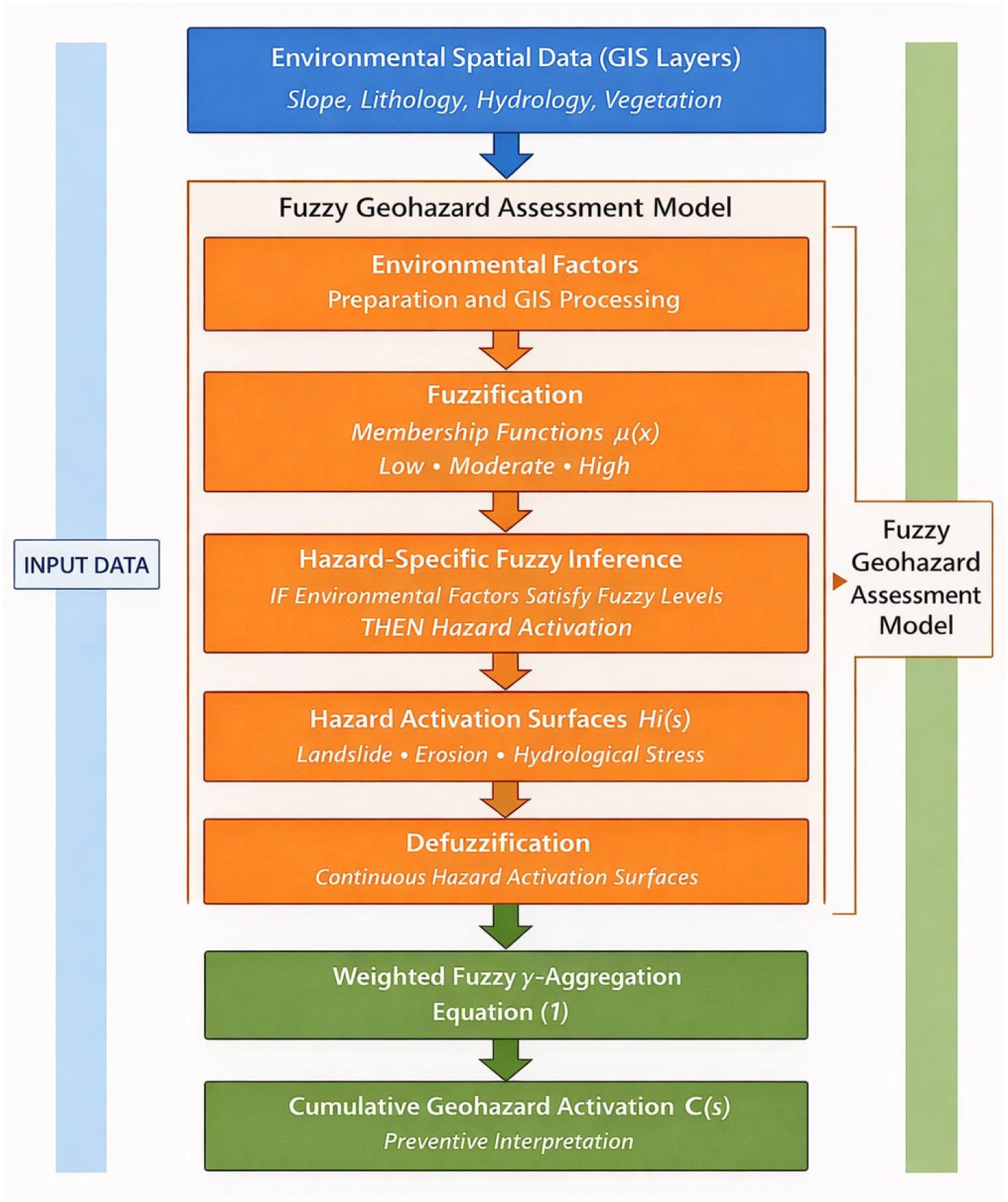
Environmental spatial data are transformed into fuzzy variables through membership functions, combined through hazard-specific fuzzy inference rules, converted into hazard activation surfaces, and subsequently aggregated using a weighted fuzzy γ operator to derive cumulative geohazard activation, supporting preventive interpretation in heritage landscapes (Figure 1).
The following subsection formalizes this analytical structure by specifying the fuzzy representation of environmental variables, the rule-based inference used to derive hazard activation, and the aggregation procedure used to synthesize cumulative geohazard conditions.

4.2. GIS-Based Implementation and Spatial Processing

The fuzzy geohazard assessment approach is implemented within a GIS environment that represents environmental heterogeneity across heritage landscapes. The study domain is discretized into spatial units, typically raster cells, which serve as localized analytical units for evaluating environmental variables, hazard activation levels, and cumulative geohazard conditions.
Cell-level analysis enables the approach to capture fine-scale environmental variation while maintaining spatial consistency across the study area. Local differences in environmental conditions can directly influence hazard activation without being obscured by spatial aggregation.
The GIS environment facilitates the generation of intermediate spatial layers at successive stages of the analysis. Environmental inputs, hazard activation surfaces, and cumulative outputs can be examined independently, enhancing methodological transparency and supporting interpretation and validation through expert geomorphological assessment. Within this GIS-based structure, fuzzy membership functions and rule-based inference are used to derive hazard-specific activation levels from environmental variables.

4.3. Representation of Gradual Activation and Uncertainty Integration

The explicit representation of gradual activation constitutes a central methodological feature of the approach. Environmental processes relevant to geohazard formation do not exhibit abrupt threshold behavior but vary continuously across space [25]. By allowing spatial units to belong simultaneously to multiple activation states, the approach preserves transitions that are typically suppressed in crisp classification schemes [19,21].
Uncertainty arising from incomplete observability and spatial heterogeneity is incorporated directly through graded membership representation, allowing ambiguous or transitional conditions to influence cumulative outcomes. In practical terms, this representation is implemented through fuzzy membership functions that translate environmental variables into activation levels.

4.4. Assessment Outputs and Relevance for Heritage Management

The spatial outputs generated by the approach provide a basis for interpreting geohazard conditions as spatially continuous cumulative activation (as defined in Section 2.2) rather than static classifications. Areas of elevated relevance emerge not only where hazard activation is high but also where multiple processes converge at moderate levels under uncertainty. This perspective is particularly relevant for heritage management, where the aim is to anticipate degradation pathways.
As outputs are expressed as continuous surfaces, they support adaptive interpretation through time. Changes in environmental conditions or expert understanding can be incorporated by adjusting input layers or inference rules without altering the overall structure. This adaptability enhances long-term usefulness for heritage sites subject to evolving pressures.
The approach does not substitute expert judgment or conservation planning but provides a structured analytical context within which such judgment can be applied, reinforcing the role of spatial assessment as a support mechanism for heritage management. The following section presents the formal mathematical formulation of the approach.

5. Formalization of the Fuzzy Geohazard Assessment Approach

5.1. Spatial Domain and Analytical Scope

The fuzzy geohazard assessment approach operates over a spatial domain corresponding to the heritage area under study, discretized into spatial units, typically raster cells. This discretization provides a consistent spatial framework for integrating heterogeneous environmental information while preserving local variability. Each spatial unit functions as an analytical unit in which environmental conditions, hazard activation, and cumulative effects are evaluated.
In contrast to the original GPI formulation, which combines hazards through linear aggregation, the present approach introduces fuzzy representation and γ-based aggregation to capture gradual activation, partial hazard co-occurrence, and uncertainty within cumulative geohazard assessment.
All analytical operations are performed locally at the level of individual cells, ensuring that spatial heterogeneity and site-specific conditions are retained throughout the assessment process. Environmental factors, hazard activation, and cumulative geohazard conditions are treated as spatially explicit variables, allowing direct interpretation of intermediate and final outputs as continuous spatial surfaces. This spatially explicit formulation is essential for preventive assessment in heritage areas, where small-scale environmental variations may have disproportionate implications for asset stability. Within this framework, environmental factors associated with geohazard formation are represented through fuzzy membership functions that express the degree to which local conditions contribute to hazard activation.
Membership functions map environmental variables into normalized activation degrees μ(x) ∈ [0, 1], representing the extent to which each variable contributes to geohazard activation. Depending on the relationship between the variable and hazard processes, either increasing or decreasing functions are applied.
For linear membership functions, activation increases progressively between two threshold values defining a transition zone. Below the lower threshold, the contribution is negligible, while above the upper threshold, full activation is assumed. Between these limits, the contribution varies gradually, allowing continuous representation of intermediate states.
More complex responses may be represented using sigmoidal or piecewise functions, particularly where nonlinear behavior is expected. The selection and parameterization of membership functions are based on geomorphological reasoning, literature evidence, and expert judgment, ensuring consistency with the physical interpretation of each environmental factor.

5.2. Fuzzification of Environmental Factors

Each environmental factor contributing to geohazard activation is transformed into a fuzzy variable through membership functions μ(x) expressing degrees of membership in linguistic states such as low, moderate, and high. Membership functions map factor values to the unit interval [0, 1], allowing gradual transitions and partial activation without imposing fixed thresholds [26,27].
Fuzzification is applied directly to spatial input layers, producing continuous membership surfaces. This representation preserves information in transitional zones where environmental conditions fluctuate around conventional thresholds and reflects the continuous nature of environmental processes. In heritage contexts, where moderate conditions may justify preventive attention, fuzzification enhances sensitivity without increasing analytical complexity.
By replacing crisp classification with graded representation, fuzzification allows environmental information to retain ambiguity and contextual nuance, which are essential for uncertainty-aware interpretation [28]. The selection and shape of membership functions are guided by geomorphological understanding and expert interpretation of environmental thresholds relevant to each hazard.

5.3. Hazard-Specific Fuzzy Inference

Geohazard activation is inferred through rule-based fuzzy reasoning that integrates multiple fuzzified environmental factors relevant to each hazard. Rules are expressed in the form:
IF environmental factors satisfy specified fuzzy levels,
THEN geohazard activation corresponds to a given fuzzy level [29].
At each spatial unit, rule activation is computed using standard fuzzy operators, such as the minimum or product, to represent conjunctive behavior among contributing factors. The outputs of all applicable rules are then combined to derive a fuzzy representation of hazard activation. This inference process allows partial activation to emerge under moderate or uncertain conditions, rather than requiring extreme factor values to trigger high hazard states.
By structuring inference around partial activation and rule interaction, the approach aligns formalization with the gradual and cumulative nature of geohazard processes.

5.4. Defuzzification and Continuous Hazard Representation

Fuzzy hazard representations are converted into continuous hazard activation surfaces through defuzzification using the centroid method [30]. Defuzzification provides a scalar representation of hazard activation that facilitates comparison and subsequent aggregation while preserving the information encoded in fuzzy membership distributions.
Importantly, defuzzification is applied without reintroducing crisp classification thresholds. The resulting activation surfaces express hazard intensity on a continuous scale, maintaining spatial continuity and avoiding abrupt transitions. This step serves as a bridge between fuzzy inference and cumulative aggregation, supporting operational use within a GIS environment without reducing sensitivity [31].

5.5. Fuzzy Cumulative Aggregation of Geohazards

Cumulative geohazard conditions are derived by aggregating hazard-specific activation surfaces through fuzzy aggregation operators [32]. A weighted fuzzy γ operator is used to combine geohazards, allowing both conjunctive and disjunctive behavior, depending on the level of precaution [33]. As γ approaches 0, the operator emphasizes conjunctive behavior, whereas values approaching 1 increase disjunctive amplification. The cumulative geohazard condition is computed using the weighted fuzzy γ aggregation operator defined in Equation (1):
C ( s ) =   ( i = 1 n H i ( s ) W i ) 1 γ   ( 1   i = 1 n ( 1 H i ( s ) ) W i ) γ
C(s) denotes the cumulative geohazard activation at spatial unit s,
Hi(s) ∈ [0, 1] denotes the fuzzy activation level of hazard i at spatial unit s,
Wi represents the weight assigned to hazard i,
and γ ∈ [0, 1] controls the degree of precautionary aggregation.
Hazard weights Wi are normalized so that Σ Wi = 1.
In Equation (1), s denotes a spatial location within the study area, corresponding to a raster cell in the GIS representation of the landscape. The function C(s) represents a scalar field defined over the spatial domain, assigning to each location a cumulative activation value derived from fuzzy aggregation.
The activation function C(s) does not represent an operator in the strict mathematical sense but a spatially distributed scalar quantity resulting from the combination of membership values through fuzzy inference and aggregation. Its properties are determined by the selected aggregation scheme (e.g., γ operator), which controls the balance between conjunctive and disjunctive behavior.
In practical implementation, the spatial domain is discretized into a finite set of raster cells, and C(s) is evaluated at each cell. This discretized representation may be interpreted as a finite array; however, the formulation is not intended as a matrix operator or a functional mapping in the sense of classical operator theory.
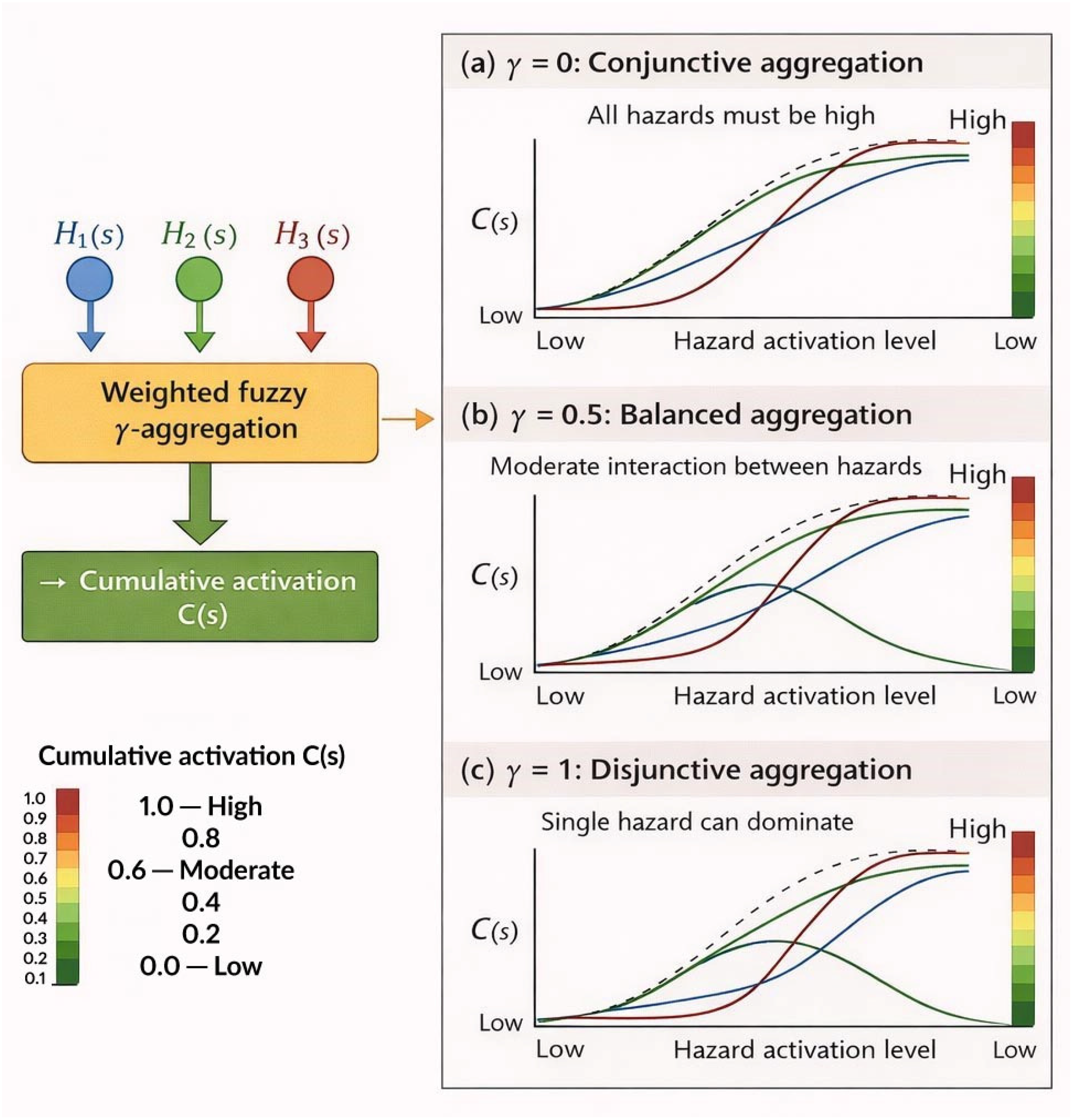
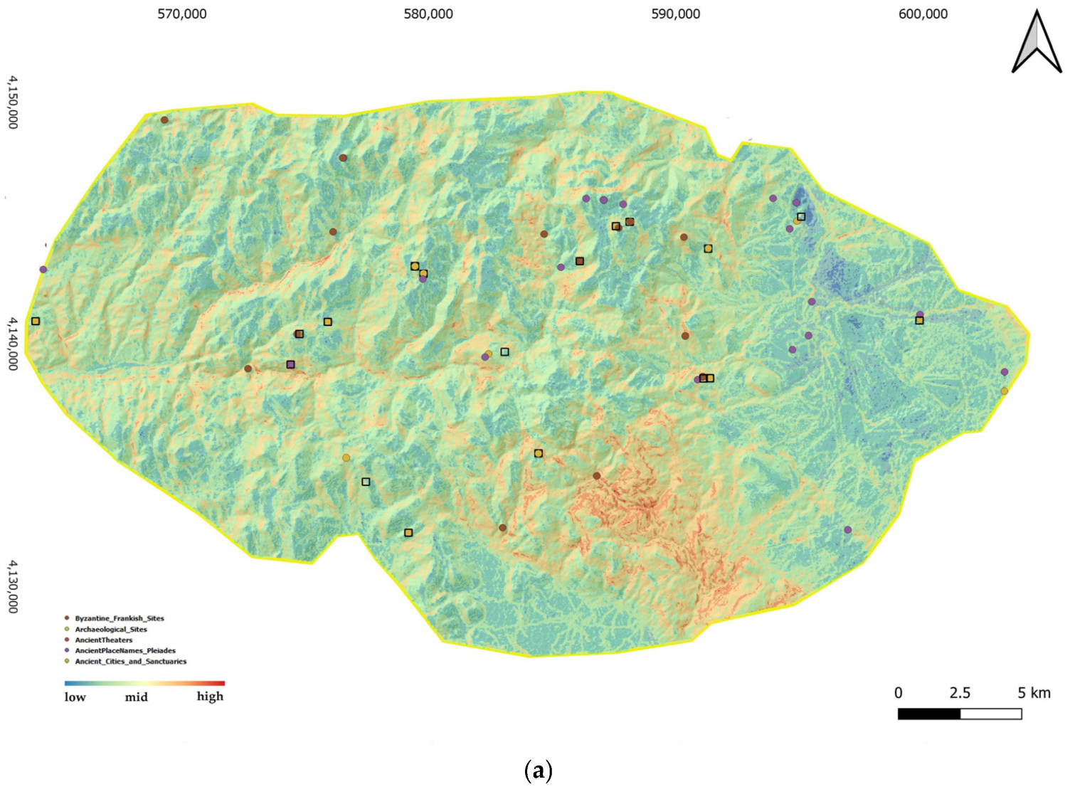
Higher values of γ emphasize conservative interpretation, consistent with the requirements of heritage protection (Figure 2). The weighted fuzzy γ aggregation operator controls the balance between conjunctive and disjunctive aggregation. Lower values emphasize simultaneous activation of multiple hazards, whereas higher values increase precautionary amplification when individual hazards exhibit elevated activation levels.
The resulting value C(s) represents a fuzzy degree of cumulative geohazard activation, expressing preventive concern rather than probability or expected damage. This aggregation allows cumulative conditions to emerge from interacting hazards that exhibit only moderate activation, reinforcing the preventive orientation of the assessment [33,34,35].
A detailed explanation of the operator and its mathematical properties is provided in Appendix A.

5.6. Treatment of Uncertainty Within the Assessment Process

Uncertainty is incorporated implicitly throughout the assessment process through partial memberships, overlapping hazard states, and fuzzy aggregation. Rather than being minimized or externalized, it influences cumulative outcomes by amplifying concern in areas characterized by ambiguous or transitional conditions.
This treatment reflects the conditions typical of heritage contexts, where incomplete observability and evolving environmental processes are common. By allowing uncertainty to contribute directly to cumulative assessment, the approach reduces the risk of systematic underestimation and supports conservative interpretation aligned with heritage management priorities.
This effect arises from the ability of the γ aggregation operator to retain the influence of multiple partially activated factors, even when none individually reaches high activation levels. In contrast to linear aggregation, where moderate contributions may be averaged out, the γ operator preserves the co-occurrence of such conditions and, depending on parameterization, amplifies their combined effect. As a result, areas characterized by the spatial convergence of moderate processes are less likely to be underestimated within the cumulative assessment.
This property is particularly relevant in heritage landscapes, where gradual and interacting processes often precede visible damage. From a management perspective, the ability to detect such emerging cumulative conditions supports precautionary decision making, enabling early intervention, monitoring prioritization, and the protection of sensitive assets before irreversible impacts occur.

5.7. Summary of Methodological Characteristics

The fuzzy geohazard assessment approach presented in this section is characterized by:
  • spatially explicit, cell-based implementation in a GIS environment,
  • fuzzy representation of environmental factors and hazard activation,
  • rule-based inference supporting partial and gradual activation,
  • fuzzy aggregation enabling cumulative geohazard interpretation,
  • explicit sensitivity to uncertainty consistent with preventive objectives.
These characteristics operationalize the methodological evolution of cumulative geohazard assessment outlined in previous sections and provide the analytical basis for heritage-oriented geohazard interpretation and management discussed in the following section.

6. Spatial Application of the Fuzzy Geohazard Assessment Approach

6.1. Study Area and Geographical Setting

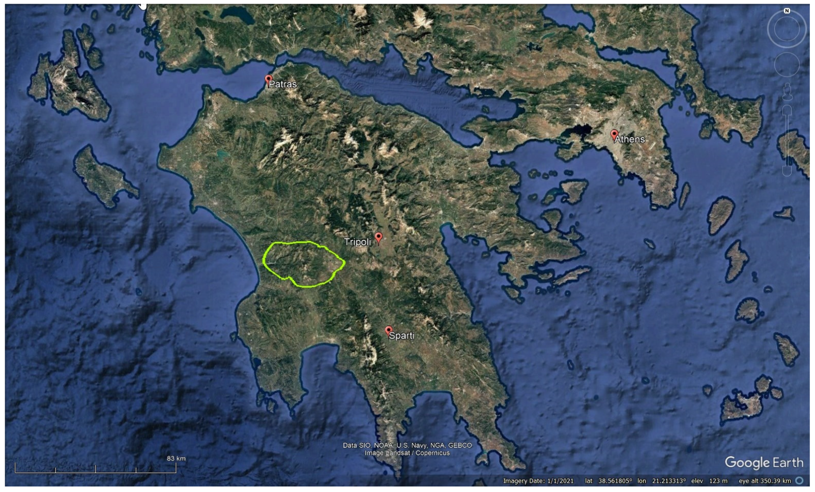
The application presented here is intended as a demonstrative implementation of the approach rather than a full multi-hazard risk assessment. The spatial application of the fuzzy geohazard assessment approach was conducted in Parrhasian Heritage Park, a mountainous cultural landscape located in the western part of Central Peloponnese (Figure 3). The park extends over approximately 670 km2 and occupies a transitional geographical zone spanning portions of Arcadia, Elis, and Messinia [36].
Geomorphologically, the area is defined by a pronounced mountainous envelope formed by three major relief units: Mount Minthi to the north, Mount Tetrazion to the south, and Mount Lykaion to the east. These mountain masses enclose the deeply incised valley of the Neda River, which flows east to west and discharges into the Kyparissiakos Gulf. The relief is strongly dissected, characterized by steep slopes, narrow gorges, and marked elevation contrasts, creating conditions favorable to slope instability and erosion processes [37].
The area lies at the boundary between two principal hydrological basins (GR29 and GR32), with Mount Lykaion functioning as a watershed divide. The drainage network exhibits pronounced incision and localized hydrological concentration, particularly along the Neda Gorge, enhancing geomorphic dynamism. From a geological perspective, the landscape is dominated by limestone formations, tectonic structures, and complex stratigraphic sequences that have shaped both terrain morphology and cultural settlement patterns. The geomorphological setting includes steep carbonate slopes, weathered limestone surfaces, localized marble units, sandstone formations, and structural discontinuities that influence mass movement processes. The interplay between lithology, slope gradient, precipitation, and vegetation cover generates spatially differentiated susceptibility to landslides, surface erosion, weathering, and localized subsidence.
Climatically, the region reflects typical Mediterranean mountainous conditions, with episodic high-intensity rainfall events, seasonal variability, and strong thermal contrasts. These characteristics contribute to progressive geomorphic activity rather than exclusively catastrophic events, reinforcing the suitability of the area for demonstrating cumulative geohazard modeling.
Beyond its geomorphological dynamics, the Parrhasian landscape also hosts significant archaeological and cultural assets, including sanctuaries, temples, fortified settlements, and historic villages distributed across morphologically sensitive terrain. Many of these features are located on elevated ridges, slope transitions, or valley margins, where long-term exposure to geomorphic processes may gradually compromise structural stability.
The study domain was discretized into 5 m raster cells to preserve fine-scale terrain variability captured by the available digital elevation model. All environmental inputs and subsequent hazard activation surfaces were processed at the cell level, ensuring spatial consistency throughout the application.
The spatial implementation of the proposed fuzzy geohazard assessment approach followed four sequential analytical steps. First, environmental raster layers representing geomorphological controls were prepared and harmonized within a common spatial framework. Second, these variables were transformed into fuzzy membership surfaces expressing gradual activation conditions. Third, hazard-specific fuzzy inference was applied to derive landslide and surface erosion activation layers. Finally, the resulting hazard surfaces were aggregated through the weighted fuzzy γ operator to produce cumulative geohazard activation maps under different precautionary scenarios.
The purpose of the present application is methodological demonstration rather than predictive hazard modeling. Parrhasian Heritage Park therefore serves as a representative mountainous heritage landscape used to illustrate the behavior of the fuzzy cumulative assessment framework under realistic environmental conditions.

6.2. Environmental Inputs and Spatial Data Preparation

The spatial implementation of the fuzzy geohazard assessment approach follows a structured four-step workflow:
(1)
environmental variables are prepared and harmonized as spatial raster inputs;
(2)
fuzzification is applied through membership functions to transform variables into graded activation surfaces;
(3)
hazard-specific fuzzy inference is performed, and the resulting fuzzy outputs are converted into continuous activation surfaces through centroid defuzzification;
(4)
the resulting hazard activation layers are aggregated using the weighted fuzzy γ operator to derive cumulative geohazard activation patterns.
This workflow ensures that each step of the modeling process is explicitly defined and operationalized within a GIS environment.

6.2.1. Data Sources and Variable Selection

The spatial application utilized environmental variables representing primary geomorphological controls on slope instability and surface degradation processes within the study area (Table 1). Variable selection was guided by geomorphological reasoning and previous cumulative geohazard assessment applications in mountainous Mediterranean environments.
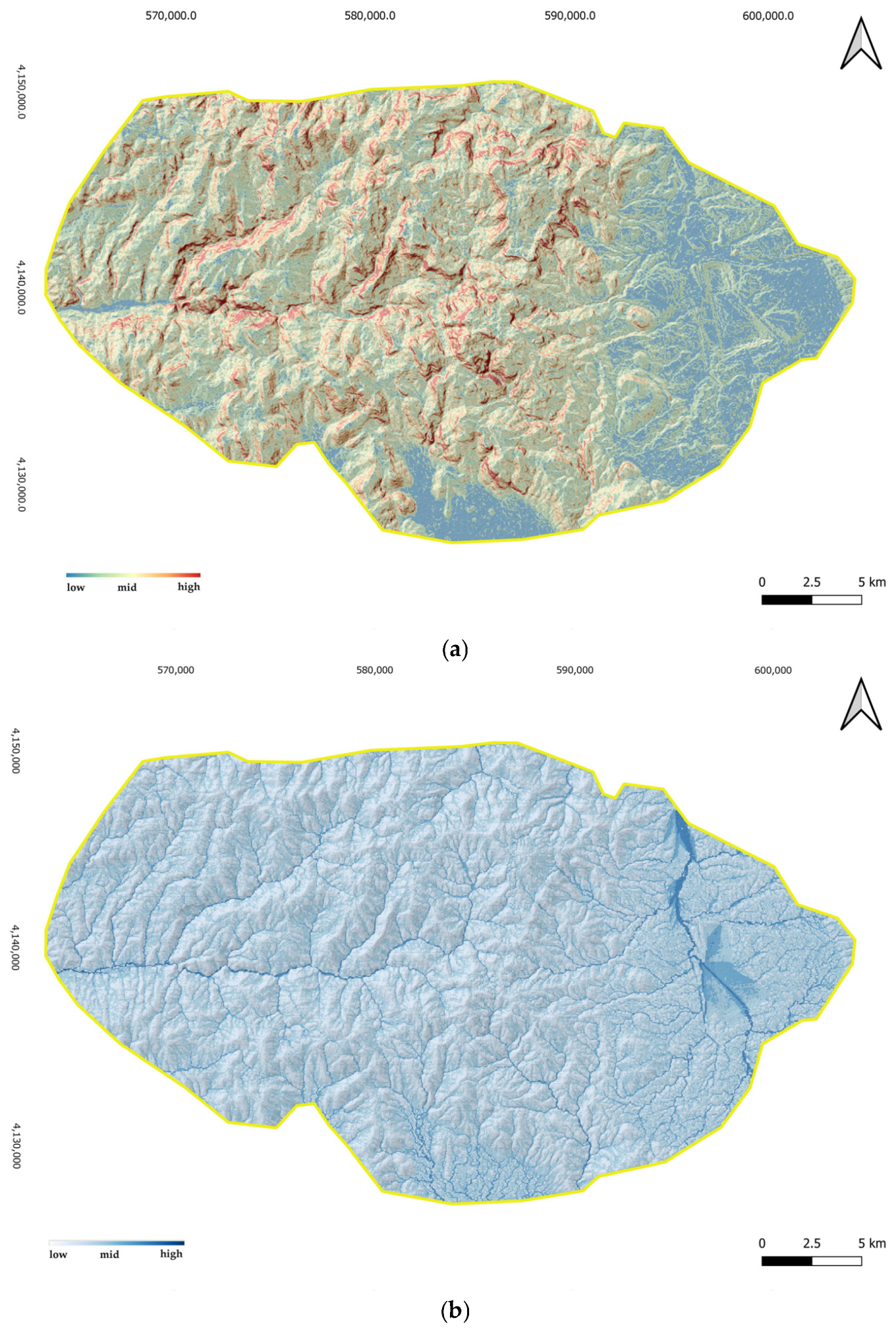
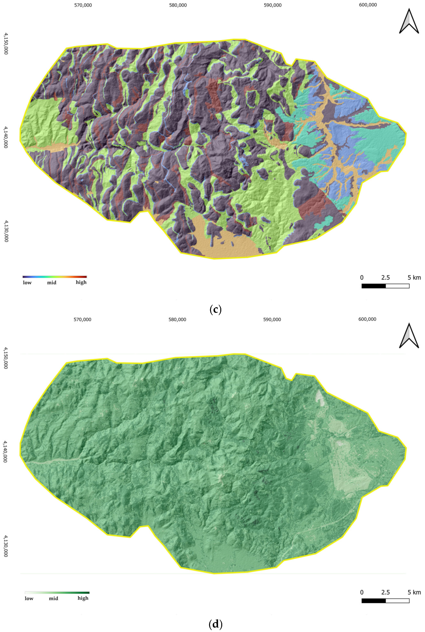
Slope gradient was incorporated as the principal driver of gravitational instability and erosional acceleration. Lithological susceptibility reflects material resistance and structural discontinuities influencing mass movement processes. Distance to drainage was used as a proxy for hydrological concentration and fluvial incision effects. Land cover density represents surface protection, soil cohesion, and vegetation-mediated stabilization (Figure 4).
The selected variables represent complementary geomorphic controls rather than purely statistical predictors, thereby preserving interpretability within a preventive assessment framework.
All datasets were projected in a common coordinate reference system (WGS84) and clipped to the study area boundary.

6.2.2. Spatial Processing and Harmonization

All spatial processing was conducted within a GIS environment using QGIS (version 3.40.11). Raster analyses were implemented using standard terrain analysis and spatial analyst tools.
The DEM was used to derive slope gradient using a second-order finite difference algorithm. Geological vector layers were converted to raster format using majority assignment at the cell level. Euclidean distance to drainage was calculated from the hydrographic network to represent localized hydrological concentration. Land cover classes were reclassified into ordinal vegetation density categories reflecting protective capacity.
All datasets were projected in the World Geodetic System 1984 (WGS84) and harmonized to a 5 m raster grid. No spatial smoothing, threshold-based discretization, or normalization procedures were applied prior to fuzzy transformation to preserve intrinsic spatial variability.
The resulting harmonized raster layers constituted the operational input set for the fuzzy modeling workflow. Specifically, slope, lithological susceptibility, distance to drainage, and vegetation density were retained as the four spatial predictor layers subsequently transformed into fuzzy membership surfaces.

6.2.3. Preparation for Fuzzy Transformation

Prior to fuzzification, all variables were standardized into continuous numerical ranges compatible with membership function formulation. This ensured comparability across heterogeneous datasets while avoiding information loss associated with premature classification.
The harmonized raster layers formed the spatial input basis for hazard-specific fuzzy inference described in the following section. This step ensured that each environmental layer could be translated into a comparable fuzzy representation while preserving its geomorphological meaning. In practical terms, the harmonized rasters were used directly to define variable specific membership functions without prior threshold-based classification.

6.3. Fuzzy Representation and Hazard-Specific Inference

The fuzzy inference stage was implemented using four environmental variables and two hazard components, landslide activation and surface erosion, selected to represent the dominant geomorphological processes operating within the study area.

6.3.1. Fuzzy Membership Formulation

Following spatial harmonization, the environmental variables were transformed into fuzzy membership surfaces representing degrees of participation in linguistic states such as low, moderate, and high activation.
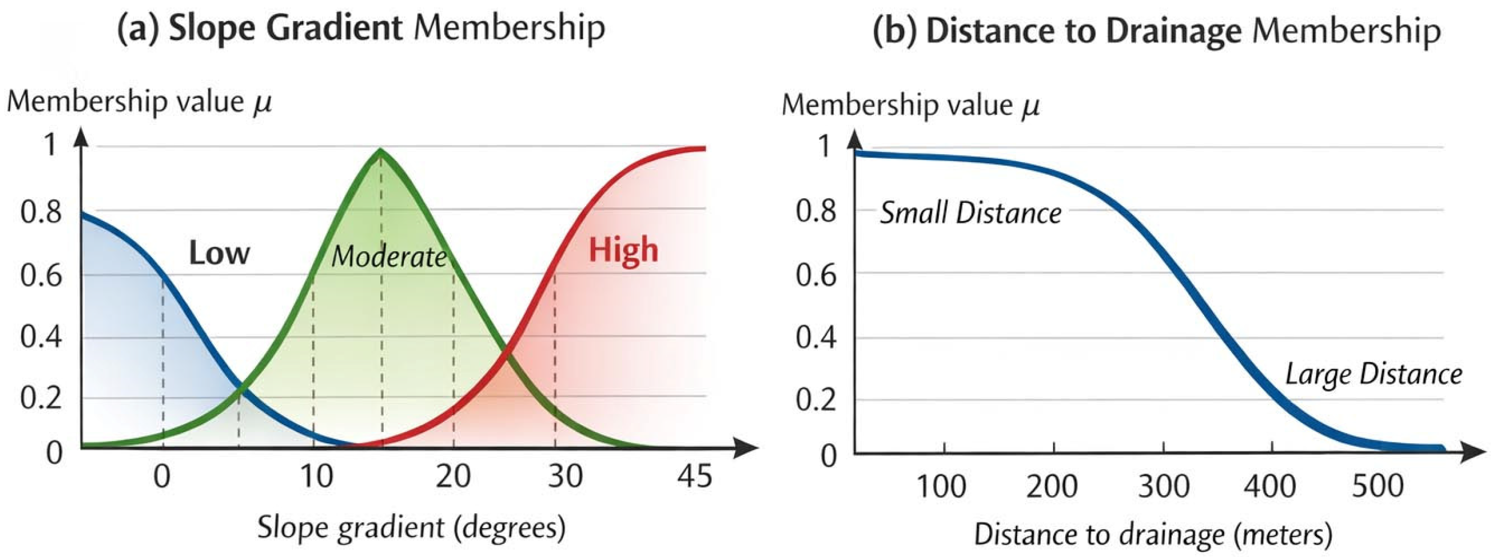
Membership functions were defined based on geomorphological process understanding rather than purely statistical distribution. For continuous variables (e.g., slope gradient and distance to drainage), sigmoidal, triangular, or linear functions were employed to preserve gradual transitions in hazard activation (Figure 5). For lithological susceptibility, categorical units were assigned graded membership values reflecting the relative resistance of materials to gravitational and erosional processes (Table 2).
For example, the fuzzy representation of high slope activation was expressed as (Equation (2)):
μ H i g h S l o p e ( x ) = 1 1 + e a ( x b )
where x is the slope gradient (in degrees), b denotes the transition midpoint, and a controls the steepness of activation growth. This formulation ensures a smooth transition between stability conditions without introducing abrupt threshold discontinuities.
Equation (2) expresses the sigmoidal membership function used to represent gradual activation of individual variables. The formulation ensures smooth transitions without imposing threshold discontinuities.
Parameter a is used in the definition of membership functions (Section 6.3.1) and represents threshold values defining the lower and upper bounds of transition zones for each environmental variable. Parameter b denotes the inflection point of the transition zone, while a controls the steepness of the sigmoid. These parameters are not unknown variables to be estimated but are predefined based on geomorphological reasoning, literature evidence, and expert judgment. Their values are therefore constrained within the physical range of each variable (e.g., slope, distance, or the NDVI).
The fuzzy analysis implemented in this study does not involve solving an inverse or optimization problem. No unknown variables are estimated through calibration. Instead, the method operates as a forward evaluation framework, where environmental variables are transformed into membership values and combined through rule-based inference and aggregation. The number of variables corresponds to the set of environmental factors included in the analysis (e.g., slope, lithology, hydrological proximity, and vegetation), each represented through its respective membership functions. The resulting cumulative activation C(s) is therefore a deterministic function of these inputs within the fuzzy framework.
All membership values were bounded within the interval [0, 1], ensuring compatibility with subsequent fuzzy inference operations. The parameterization of the membership functions was guided by geomorphological reasoning, inspection of local data ranges, and consistency with slope instability conditions reported for Mediterranean mountainous environments.
The membership functions employed for each variable are defined as follows. For slope gradient, the high activation state is represented using a sigmoidal function, producing a smooth, monotonically increasing transition centered on slope values where gravitational instability becomes pronounced in Mediterranean mountainous terrain. The moderate state is defined by a triangular function capturing transitional instability conditions, while the low state is defined as the complement of the high function, ensuring a smooth decrease in low activation membership as slope increases.
For distance to drainage, an inverse sigmoidal function is used to represent proximity, expressing the progressive decay of hydrological influence with increasing distance from the channel network. For lithological susceptibility, scalar membership values are assigned to geological units based on geomechanical criteria and distributed spatially through rasterization. For vegetation density, a linearly decreasing function is applied to represent reduced surface protection under low vegetation cover.
In all cases, adjacent linguistic states are designed to overlap within transitional ranges, allowing spatial units to hold simultaneous partial membership across multiple states and preserving geomorphological continuity through subsequent inference and aggregation.
For the sigmoidal slope function, the midpoint parameter b was set to represent the slope range at which instability increases in the study area, while the steepness parameter a was selected to produce a gradual transition from moderate to high activation. In this way, the adopted functions reflect process behavior and spatial continuity rather than impose rigid threshold effects.
The parameter values used in the membership functions (Table 2) are defined based on geomorphological reasoning, literature evidence, and expert judgment. These values are not derived through statistical calibration but are selected to reflect physically meaningful thresholds and transition ranges associated with each environmental variable. For example, slope-related thresholds correspond to ranges associated with the onset of gravitational instability in Mediterranean mountainous environments, while distance to drainage parameters reflect the spatial extent of hydrological influence on surface processes. Vegetation-related parameters capture the protective role of surface cover.
The graded lithological susceptibility values were assigned based on three geomechanical criteria: material strength and cohesion, degree of weathering and surface alteration, and density of structural discontinuities. Massive unweathered limestone with low discontinuity density was assigned low susceptibility membership, reflecting high resistance to gravitational failure. Sandstone and moderately weathered carbonate formations with intermediate discontinuity density received moderate membership, consistent with variable cementation and susceptibility to surface disaggregation. Weathered limestone surfaces and marble outcrops, where structural anisotropy and alteration introduce preferential failure geometries, were assigned higher susceptibility membership. This ranking is consistent with geomechanical characterizations of lithological susceptibility in Mediterranean slope stability contexts and extends the susceptibility classification structure of the GPI framework [5].
The parameter values summarized in Table 2 should therefore be interpreted as process-informed fuzzy transition settings rather than fixed thresholds. Their role is to ensure consistency between the fuzzy representation and the underlying physical processes while maintaining transparency and interpretability within the preventive assessment framework adopted in this study.
Figure 5 illustrates indicative fuzzy membership functions used for the transformation of environmental variables into fuzzy activation surfaces. (a) Overlapping membership functions for slope gradient representing low, moderate, and high instability states. (b) Inverse sigmoidal membership function describing decreasing hazard activation with increasing distance from drainage channels. The curves demonstrate smooth transitions between linguistic states and the absence of abrupt activation thresholds. The overlapping structure allows spatial units to partially belong to multiple states simultaneously, thereby preserving transitional geomorphological conditions. In implementation terms, these functions were applied cell by cell to the harmonized raster layers, converting each environmental variable into a continuous fuzzy membership surface across the study area.
Parameter values were selected based on geomorphological reasoning and typical activation ranges reported in slope stability studies in Mediterranean mountainous environments. The selected ranges were further examined through sensitivity testing to ensure that moderate parameter variations do not substantially alter the spatial structure of cumulative activation patterns. The resulting membership layers constitute the fuzzy input space upon which hazard-specific inference rules are subsequently applied. In addition, the calibration of membership transitions was cross-checked against the empirical distribution of environmental variables within the study area to ensure that the selected parameters represent meaningful geomorphological activation ranges rather than arbitrary thresholds.
It should be emphasized that the linguistic states low, moderate, and high do not constitute discrete categories. Each state is defined by a continuous membership function that maps raw factor values to graded degrees of activation within [0, 1], allowing spatial units to simultaneously hold partial membership across multiple states. Continuous numerical values therefore underpin the full representation, while the linguistic labels serve solely to organize inference rules in an interpretable form without imposing crisp boundaries. The transition parameters reported in Table 2 define the shape and position of these functions based on geomorphological process thresholds characteristic of Mediterranean mountainous terrain and the empirical value distributions observed within the study area.
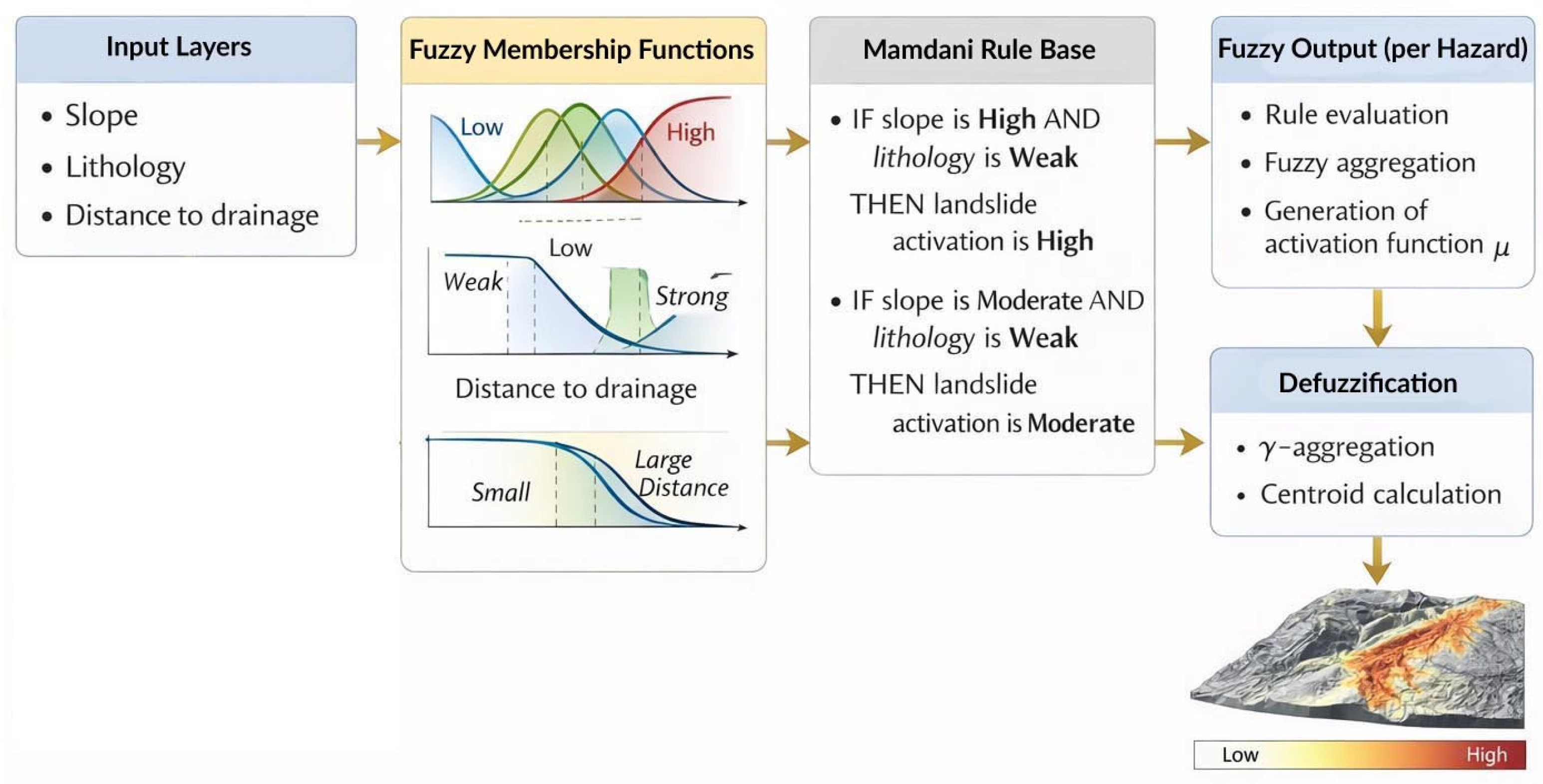
The overall fuzzy inference workflow adopted in the present study is illustrated in Figure 6.
Figure 6 summarizes the fuzzy inference pipeline adopted in the demonstrative application. Environmental variables are first transformed into fuzzy membership values, which are then combined through a Mamdani-type rule base. The resulting fuzzy outputs are subsequently defuzzified using the centroid method to produce continuous hazard activation surfaces.

6.3.2. Rule-Based Hazard Inference

Two hazard components were evaluated independently:
  • Landslide activation
  • Surface erosion activation
For the purposes of the demonstrative application, the analysis focuses on two dominant geomorphological processes: landslide activation and surface erosion. This intentionally limited hazard set allows the structural behavior of the fuzzy inference and γ aggregation mechanisms to be illustrated clearly without introducing additional complexity associated with a larger multi-hazard configuration. Fuzzy inference was implemented using a Mamdani-type rule structure, where rules were constructed to reflect geomorphological reasoning rather than data-driven optimization.
The rule base was designed to represent dominant geomorphological interactions among the selected variables. For clarity, rules constructed in accordance with the geomorphological factor structure of the GPI framework [5] are presented below.
Rules for landslide activation included:
  • IF slope is High AND lithology is Weak THEN landslide activation is High
  • IF slope is Moderate AND lithology is Weak THEN landslide activation is Moderate
  • Rules for surface erosion included:
  • IF slope is High AND drainage proximity is Small THEN erosion activation is High
  • IF slope is Moderate AND land cover is Sparse THEN erosion activation is Moderate
Conjunctive operators were implemented using the minimum function, reflecting the requirement of coactivation among contributing factors.
The rule base was executed independently for each hazard component at the raster cell level. This procedure produced two separate fuzzy output surfaces, one representing landslide activation and the other representing surface erosion activation, which were subsequently defuzzified and carried forward to the cumulative aggregation stage (Figure 7). The rule base was intentionally limited to dominant process interactions in order to maintain interpretability and avoid overparameterization.

6.3.3. Defuzzification and Hazard Activation Surfaces

Hazard activation levels were obtained through centroid defuzzification, converting fuzzy inference outputs into continuous scalar activation values for each raster cell.
The resulting activation surfaces express graded hazard intensity within the interval [0, 1], preserving spatial continuity and avoiding class-based discretization. These surfaces represent degrees of hazard activation rather than probabilities of occurrence or predicted event magnitudes.
Importantly, no post-inference threshold classification was applied prior to cumulative aggregation. This ensures that transitional and moderate activation states remain influential in the subsequent γ aggregation stage.
As a result, each hazard is represented by a continuous raster activation layer with values ranging from 0 to 1, expressing the relative degree of activation of the corresponding process across Parrhasian Heritage Park. These layers constitute the intermediate outputs of the fuzzy inference stage and serve as input variables for the cumulative synthesis stage, where multiple hazards are integrated through the fuzzy γ aggregation operator.

6.4. Cumulative γ Aggregation and Spatial Synthesis

6.4.1. Aggregation Setup

Following hazard-specific fuzzy inference and defuzzification, landslide and surface erosion activation surfaces were combined using the weighted fuzzy γ aggregation operator described in Section 5.
For the purposes of the demonstrative application, equal weights were assigned to both hazard components (W1 = 0.5, W2 = 0.5), reflecting equivalent preventive importance within the geomorphological setting. This neutral weighting configuration was selected to isolate the influence of the γ parameter on cumulative spatial patterns.
The γ parameter operates exclusively at this cumulative synthesis stage and plays no role in hazard-specific inference. Each hazard activation surface is derived independently through its own fuzzy rule base and defuzzification procedure; γ is applied to the resulting activation surfaces during aggregation, governing the precautionary orientation of cumulative synthesis uniformly across all hazard components.
All aggregation operations were performed at the raster cell level, ensuring spatially explicit synthesis without spatial generalization or neighborhood smoothing.

6.4.2. Influence of the Precautionary Parameter

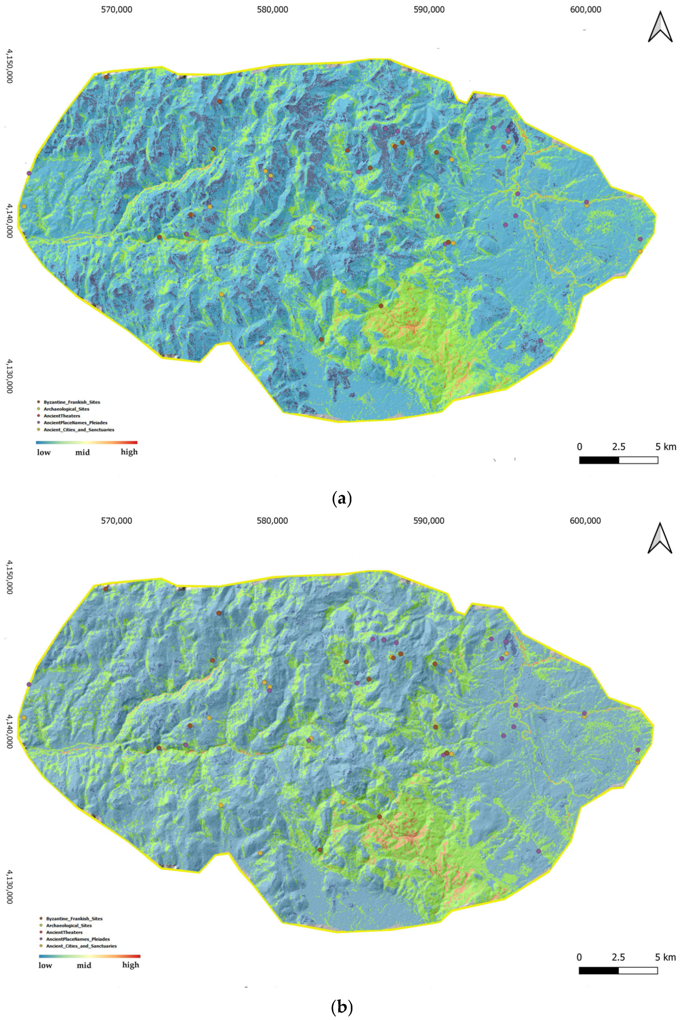
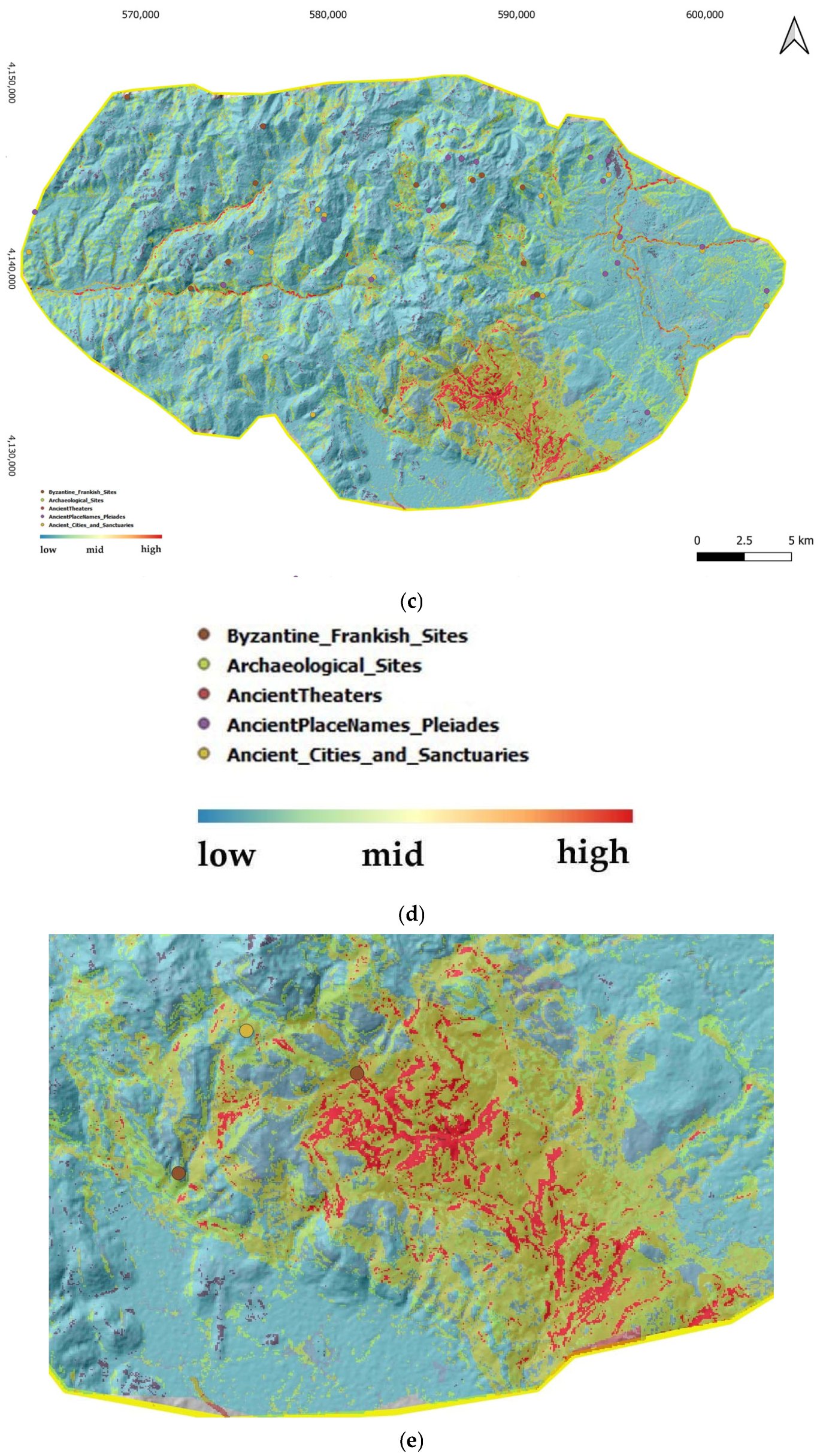
Three γ values were evaluated to illustrate the effect of precautionary orientation:
  • γ = 0.3 (conjunctive tendency)
  • γ = 0.6 (balanced interpolation)
  • γ = 0.9 (disjunctive precautionary tendency)
Under lower γ values, cumulative activation remained concentrated in zones where both hazards exhibited high activation simultaneously. As γ increased, cumulative activation expanded into areas characterized by moderate but spatially convergent hazard conditions.
This behavior reflects the structural properties of the γ operator, which interpolates between strict joint activation and precautionary amplification of partial activation.
At this stage, the two hazard-specific activation rasters were synthesized into a single cumulative geohazard activation surface. The γ operator was applied as the final spatial synthesis step of the fuzzy workflow, combining hazard interaction and precautionary interpretation within the same analytical structure.

6.4.3. Spatial Differentiation and Preventive Patterns

Comparative spatial analysis revealed that the most significant differentiation across γ values occurred in transitional geomorphological zones, particularly along slope–drainage interfaces and lithological boundaries.
These areas typically exhibited moderate activation in both landslide and erosion components. Under conjunctive aggregation (γ = 0.3), such zones remained below high cumulative activation levels. Under precautionary aggregation (γ = 0.9), these areas emerged as spatially coherent zones of elevated preventive concern.
Quantitatively, the proportion of cells exceeding moderate cumulative activation levels (C(s) > 0.6) increased from approximately 15% (γ = 0.3) to 35% (γ = 0.9), indicating substantial sensitivity of cumulative synthesis to precautionary orientation.
The spatial expansion of activation zones occurred gradually rather than abruptly, confirming the absence of threshold artefacts. Cumulative surfaces retained continuous gradients and preserved transitional structures inherited from hazard-specific activation layers.
The resulting cumulative activation surface does not represent probability of failure or predicted event occurrence. Instead, it expresses a graded index of preventive geohazard activation under uncertainty-aware aggregation.
Summary statistics were extracted directly from the cumulative activation rasters produced for each γ scenario. The mean value of C(s), its standard deviation, and the proportion of spatial units exceeding the reference activation level (C(s) > 0.6) were calculated to examine sensitivity to the precautionary parameter.
As shown in Table 3, increasing γ systematically raises both the mean cumulative activation and the proportion of spatial units exceeding moderate concern levels. The increase in standard deviation indicates that precautionary aggregation enhances spatial variability by amplifying transitional zones rather than uniformly scaling hazard intensity.
These values are not intended as predictive accuracy measures but as internal indicators of model behavior under varying aggregation settings. Their purpose is to quantify the response of the cumulative surface to shifts from conjunctive to precautionary fuzzy synthesis. This confirms that the observed spatial differentiation arises from the structural properties of the γ operator rather than differences in input data or weighting configuration.
A brief analytical note examining the environmental class distributions underlying these cumulative activation patterns is provided in Appendix B.
Although the objective of the study is methodological rather than predictive hazard modeling, a qualitative spatial consistency check was conducted. Areas exhibiting elevated cumulative activation broadly correspond with geomorphologically sensitive terrain sectors, particularly along steep slope–drainage interfaces and weathered carbonate formations.
Future research may integrate landslide inventories or erosion observations to evaluate the correspondence between cumulative fuzzy activation patterns and observed geomorphological events.
Taken together, these steps complete the operational workflow from environmental input preparation to hazard-specific inference, defuzzified activation mapping, and cumulative synthesis (Figure 8).

6.4.4. Empirical Spatial Consistency and Discrimination Assessment

To examine the spatial consistency of cumulative fuzzy geohazard activation patterns, a validation exercise was conducted using field observations collected during site visits within Parrhasian Heritage Park. During these surveys, locations exhibiting visible geomorphological activity associated with the two hazard components considered in this study (landslide activation and surface erosion) were recorded as point observations.
A total of 45 field observation points were identified across the study area. The geographic coordinates of these observations were imported into the GIS environment and overlaid with the cumulative fuzzy activation surface C(s) derived from the γ aggregation model under the balanced precautionary setting (γ = 0.6). Raster values of C(s) were subsequently extracted at each observation location.
The distribution of cumulative activation values at the observation points was compared with the overall spatial distribution across the study area. This comparison evaluates the spatial discrimination capacity of the cumulative fuzzy activation surface, that is, its ability to concentrate observed geomorphological activity within areas characterized by elevated cumulative activation.
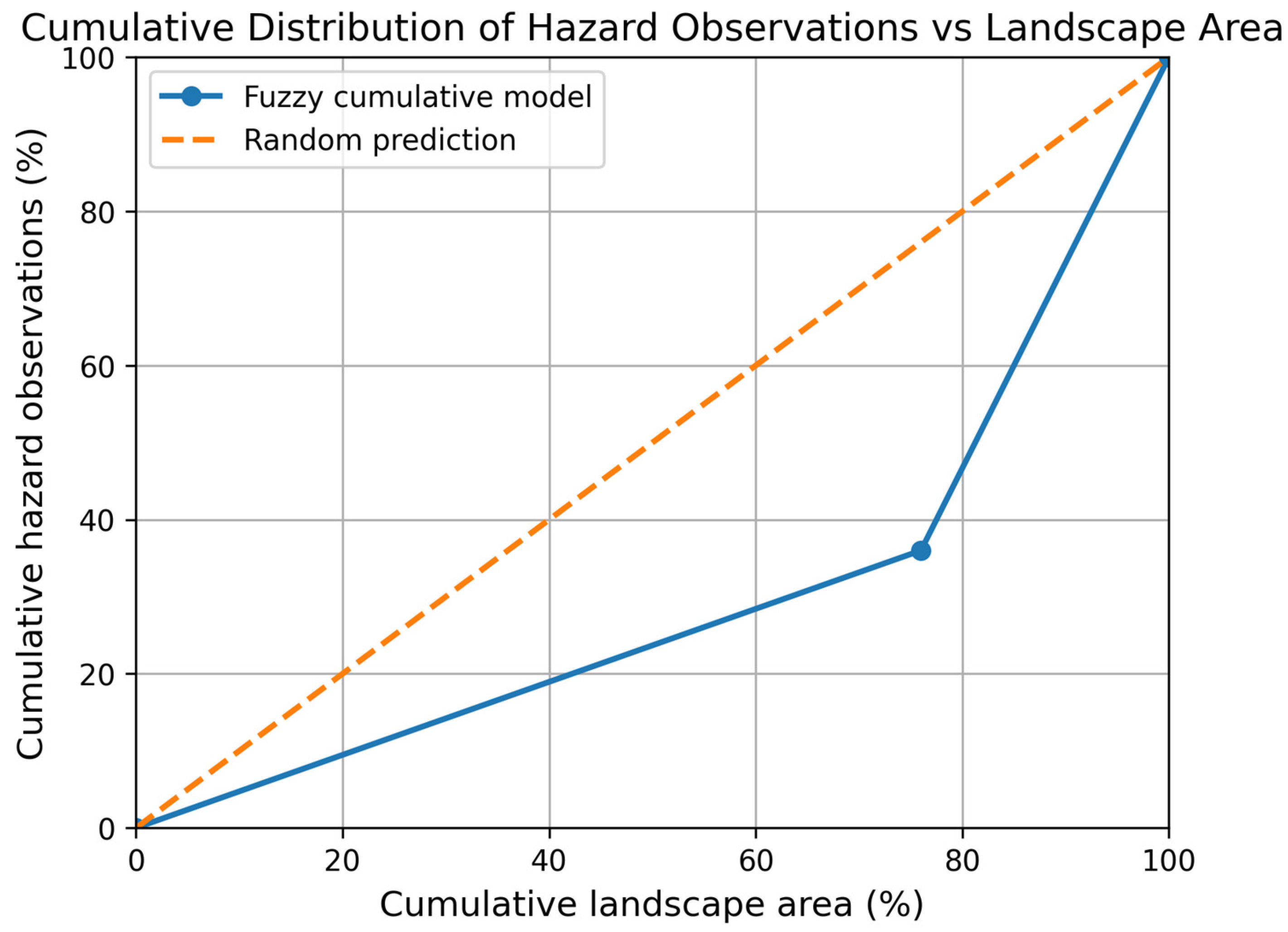
Results indicate that 29 out of 45 observed hazard locations (64.4%) occur in areas where cumulative activation exceeds C(s) > 0.6. In contrast, only 24% of the total landscape area exhibits values above this threshold (Table 4). This concentration of observed hazard locations within a limited portion of the landscape suggests that the cumulative fuzzy activation surface successfully captures terrain sectors characterized by elevated geomorphological sensitivity.
The results demonstrate that observed geomorphological activity is disproportionately concentrated within areas of elevated cumulative activation. While less than one-quarter of the landscape exceeds the reference activation level, nearly two-thirds of the observed hazard locations occur within this zone. This pattern indicates that the cumulative fuzzy activation surface provides meaningful spatial discrimination between geomorphologically active terrain sectors and the broader landscape.
To further illustrate this relationship, a cumulative distribution analysis was performed by ranking the landscape according to cumulative activation values and comparing the cumulative proportion of observed hazard locations with the cumulative proportion of landscape area (Figure 9). Such cumulative success rate plots are widely used in geohazard susceptibility studies to evaluate the spatial discrimination ability of hazard indicators.
The resulting curve shows that 64.4% of the observed hazard locations occur within the 24% of the landscape exhibiting the highest cumulative activation values. The model curve lies above the random prediction line, indicating that hazard observations are preferentially concentrated within the higher activation portion of the cumulative fuzzy surface.
The curve indicates that 64.4% of observed hazard locations occur within the 24% of the landscape exhibiting the highest cumulative activation levels, demonstrating meaningful spatial discrimination of geomorphologically active terrain sectors.
While Figure 9 presents the comparison with random prediction as a reference baseline, the performance of the fuzzy γ aggregation approach can be further evaluated against a conventional linear aggregation method using the same input variables and weighting scheme (Table 4). The results show that the fuzzy approach produces a stronger spatial concentration of high activation values, whereas linear aggregation distributes activation more uniformly across the landscape.
This difference reflects the ability of the fuzzy γ operator to capture interaction effects between contributing factors, leading to enhanced spatial discrimination of geomorphologically active zones compared to linear aggregation.
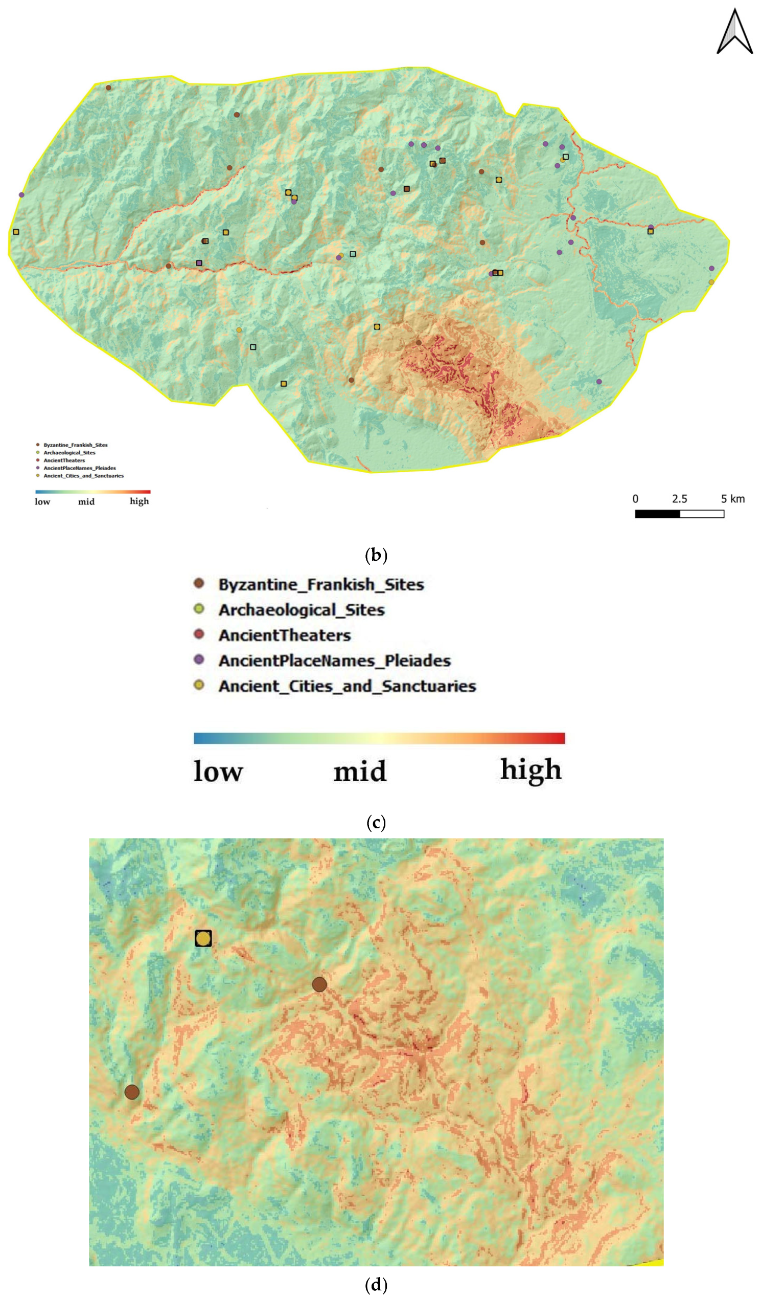
Figure 7 and Figure 8 show the spatial distribution of cumulative activation. The high activation zones identified in these figures correspond to spatial clusters where multiple contributing factors co-occur, particularly in areas characterized by steep slopes, susceptible lithological units, and proximity to drainage networks. These zones represent spatial concentrations of cumulative activation and may be interpreted as priority areas for monitoring and preventive management.
It should be emphasized that the objective of this analysis is not predictive validation of discrete hazard events. Rather, the purpose of the spatial comparison is to examine whether the cumulative fuzzy activation surface highlights terrain sectors where geomorphological processes are observed to be active or emerging. Although the number of field observations does not constitute a complete event inventory, it is sufficient to support an empirical spatial consistency check of the cumulative fuzzy activation surface.
Figure 9 confirms that observed geomorphological activity is preferentially concentrated within areas of elevated cumulative activation, demonstrating the spatial discrimination capacity of the fuzzy γ aggregation surface.

7. Discussion

7.1. Methodological Contribution of the Fuzzy Geohazard Assessment Approach

Conventional cumulative indices often rely on crisp classification and linear aggregation, which may reduce sensitivity to gradual activation and interacting moderate processes. The proposed fuzzy framework addresses these representational limitations while preserving the preventive logic of cumulative geohazard assessment.
The contribution of the present study can be summarized in three methodological aspects. First, environmental variables and hazard activation conditions are represented as spatial fuzzy sets, allowing gradual transitions and partial activation states to be retained within the assessment process. Second, hazard formation and hazard interaction are explicitly separated through a two-stage analytical structure, improving the interpretability of intermediate outputs. Third, cumulative synthesis is performed through the weighted fuzzy γ aggregation operator, enabling precautionary interpretation of interacting hazards under conditions of environmental uncertainty.
The approach does not seek to replace cumulative logic but to refine its internal structure. By expressing environmental factors and hazard activation levels as spatial fuzzy sets, it preserves continuous transitions and overlapping states, which more closely reflect the dynamics of environmental processes [38]. This refinement enhances the internal representational fidelity of cumulative geohazard assessment by allowing intermediate activation states to remain analytically visible.
The spatial application confirms that the approach produces activation surfaces characterized by gradual variation and convergence zones. Transitional areas remain analytically visible within cumulative outcomes. Thus, the methodological contribution is both conceptual and operational: it improves representational fidelity while remaining fully compatible with GIS-based spatial processing [39].

7.2. Precautionary Aggregation and Structured Treatment of Uncertainty

A central innovation of the fuzzy geohazard assessment approach lies in the use of the weighted fuzzy γ aggregation operator. Unlike linear summation, the γ operator introduces a controllable balance between conjunctive and disjunctive behavior [33,34]. This enables precautionary orientation to be expressed explicitly within cumulative synthesis rather than through post hoc interpretation.
As quantified in Table 3, increasing γ systematically expands zones of cumulative activation, particularly under conditions of partial hazard activation. This effect is a structural consequence of precautionary aggregation under partial activation conditions.
In heritage contexts, where underestimation of emerging degradation may lead to irreversible loss, this property is critical. The approach integrates uncertainty directly into cumulative assessment by allowing overlapping memberships and partial activation states to influence cumulative outcomes. Rather than treating ambiguity as residual noise, it is recognized as informative structure within environmental systems. The approach addresses epistemic uncertainty arising from incomplete observability and gradual process evolution through graded membership and precautionary aggregation, avoiding the need for probabilistic calibration or stochastic simulation [40,41].
In this sense, the fuzzy geohazard assessment approach operationalizes precaution in a spatially measurable form.

7.3. Spatial Convergence and Preventive Discrimination Capacity

The comparative analysis across γ values reveals that cumulative activation does not increase uniformly across the landscape. Instead, the most significant differentiation occurs in transitional zones where landslide and erosion activation spatially converge at moderate activation levels.
Such convergence zones are of direct preventive relevance, as they represent early-stage interaction between geomorphological processes. The approach enhances discrimination capacity by identifying these spatial intersections and allowing them to influence cumulative concern. It arises from the structured representation of gradual activation and interaction within fuzzy inference and aggregation.
The spatial distribution differences between fuzzy γ aggregation and linear aggregation warrant explicit interpretation beyond the summary statistics presented in Table 4. Linear aggregation concentrates high cumulative activation in zones where individual hazard values are simultaneously elevated, producing sharp spatial transitions and underweighting areas of moderate coactivation. The γ operator treats moderate coactivation as a structurally distinct condition: two hazards each present at 0.5 activation produce a different cumulative outcome than one hazard at 0.7 and another at 0.3, even when their linear weighted sum is identical. Under precautionary γ settings, the former configuration receives higher cumulative concern because the spatial convergence of co-occurring processes represents an emerging cumulative condition rather than the dominance of a single process.
This distinction has direct implications for preventive heritage management. The transitional zones amplified by fuzzy γ aggregation but suppressed under linear aggregation are precisely the terrain sectors where gradual multi-process degradation is most likely to develop before crossing conventional detection thresholds. Early preventive attention to these zones carries the highest conservation value, as intervention at the stage of partial activation is both feasible and reversible, unlike responses triggered only after linear aggregation identifies a zone as high concern.

7.4. Robustness, Transparency, and Transferability

Sensitivity testing indicates that moderate variation in membership calibration parameters produces limited changes in cumulative activation patterns, suggesting structural robustness of the approach. Expert judgment remains essential for defining membership functions and inference rules, while the intentionally limited rule base prevents over-parameterization and maintains transparency by ensuring that cumulative patterns remain interpretable rather than algorithmically opaque.
The methodological structure is transferable beyond the demonstrated mountainous Mediterranean context. By adapting environmental inputs and rule bases, the fuzzy geohazard assessment approach can support cumulative assessment in coastal archaeological zones, fluvial heritage plains, and semi-arid cultural landscapes.
Importantly, the approach does not aim to predict discrete hazard events. Its objective is preventive sensitivity under uncertainty. In this regard, it complements rather than replaces process-based modeling or event forecasting techniques. Although the approach is not intended for predictive validation of hazard occurrence, qualitative comparison with known geomorphologically sensitive terrain sectors indicates broad spatial correspondence between areas of elevated cumulative activation and zones exhibiting slope instability and erosion processes.
Future applications should evaluate the framework against larger multi-hazard inventories and independent temporal datasets to further assess predictive consistency.

7.5. Rethinking Preventive Accuracy in Heritage Geographies

The fuzzy geohazard assessment approach redefines preventive accuracy as the capacity to detect emerging cumulative activation. In contrast to conventional hazard modeling approaches that focus on predicting discrete hazardous events, the approach emphasizes the preventive interpretation of emerging cumulative activation patterns under uncertainty [42].
In heritage geographies, where cultural assets may deteriorate incrementally due to persistent moderate processes, such early recognition may be more relevant than event prediction. The approach aligns its representational structure with the epistemic realities of environmental systems. In this way, spatial geohazard assessment becomes a more effective decision support instrument for conservation-oriented planning.

7.6. Implications for Heritage Management, Transferability, and Future Perspectives

The fuzzy geohazard assessment approach has direct implications for heritage management practice. By producing continuous cumulative activation surfaces rather than discrete hazard classes, the approach supports prioritization of monitoring, preventive maintenance, and low-impact intervention strategies in a spatially differentiated form. Areas of moderate yet spatially convergent activation are often overlooked in threshold-based schemes. The approach allows these areas to be identified early and incorporated into conservation planning before irreversible degradation occurs.
Importantly, the approach does not prescribe specific management actions. Instead, it provides a structured analytical context within which expert judgment, conservation priorities, and governance constraints can be exercised transparently. Because the precautionary parameter γ is explicitly defined, heritage managers can adjust aggregation behavior to reflect institutional risk tolerance and conservation philosophy, thereby linking methodological configuration to policy orientation.
Future research may focus on multi-site comparative applications, integration with time series environmental monitoring data, and coupling with process-based or probabilistic models to explore complementary predictive and preventive capacities. Such developments would further clarify the operational boundaries of the approach while preserving its core emphasis on cumulative activation and uncertainty-aware spatial reasoning.
The approach focuses on the representation of intrinsic geomorphological and environmental controls influencing geohazard activation rather than on event-based triggering mechanisms. Meteorological and climatic variables, such as rainfall intensity or temporal variability, were not explicitly included, as the objective of the study is to identify spatial patterns of cumulative susceptibility and emerging activation conditions under long-term landscape dynamics.
At the spatial and temporal scales considered, the incorporation of static or slowly varying environmental factors provides a stable basis for preventive assessment. The integration of dynamic climatic inputs would require event-based or time-dependent modeling approaches beyond the scope of the present study.
Nevertheless, the fuzzy approach is inherently flexible and can accommodate meteorological or climatic variables as additional inputs, allowing future extensions toward dynamic hazard modeling and scenario-based analysis.

8. Conclusions

This study presents a fuzzy geohazard assessment approach tailored to the requirements of heritage areas, where cultural and natural assets are exposed to gradual, cumulative, and often uncertain environmental processes. The approach addresses representational constraints associated with geohazard assessment practices based on linear aggregation and fixed classification thresholds.
Building upon the cumulative and preventive logic of the Geohazard Prevention Index, the approach reformulates core analytical operations through fuzzy representation, rule-based inference, and fuzzy cumulative aggregation. This methodological evolution allows geohazard conditions to be expressed as degrees of activation rather than discrete classes, thereby preserving spatial continuity and sensitivity in transitional zones. As noted in Section 5.5, the cumulative activation surface expresses preventive concern rather than probability of failure or predicted event occurrence.
The study reframes preventive accuracy in heritage geohazard assessment by emphasizing the early detection of emerging cumulative activation patterns rather than the prediction of discrete hazard events. This perspective supports precautionary, prevention-oriented interpretation and strengthens the role of spatial assessment as a decision support tool for heritage management and planning. The spatial application demonstrates that cumulative fuzzy aggregation produces stable and interpretable spatial patterns under varying precautionary settings, combining methodological rigor with operational applicability.
Future research may focus on demonstrative applications to specific geohazards and heritage contexts, sensitivity analysis of fuzzy aggregation parameters, and integration with monitoring data to support adaptive conservation strategies. Such developments would further enhance the operational relevance of the approach while preserving its emphasis on uncertainty-aware cumulative geohazard assessment in heritage areas. The approach therefore contributes both a methodological refinement of cumulative geohazard assessment and a conceptual shift toward uncertainty-aware preventive spatial analysis in heritage landscapes.

Funding

This research received no external funding.

Institutional Review Board Statement

Not applicable.

Informed Consent Statement

Not applicable.

Data Availability Statement

The raw data supporting the conclusions of this article will be made available by the author on request.

Conflicts of Interest

The author declares no conflicts of interest.

Abbreviations

The following abbreviations are used in this manuscript:
GPIGeohazard Prevention Index
GISGeographical Information System
QGISQuantum Geographic Information System
DEMDigital Elevation Model
WGS84World Geodetic System 1984
GR29Alfios (Alpheios) River Basin
GR32Neda River Basin

Appendix A. Mathematical Formulation of the Fuzzy γ Aggregation Operator

The cumulative geohazard condition at spatial location s is expressed through a weighted fuzzy γ aggregation operator (Equation (A1)):
C ( s ) =   ( i = 1 n H i ( s ) W i ) 1 γ   ( 1   i = 1 n ( 1 H i ( s ) ) W i ) γ
This operator formalizes a continuous interpolation between conjunctive (AND type) and disjunctive (OR type) aggregation behavior, controlled by the parameter γ. The weighted fuzzy γ aggregation operator belongs to the broader family of parameterized fuzzy aggregation operators that interpolate between t norm and t co-norm behavior, as originally discussed in the foundational literature on fuzzy set theory and aggregation [18,28,33,35]. It is used here as an uncertainty-aware mechanism for cumulative synthesis of fuzzy hazard activation levels.

Appendix A.1. Definitions and Domain

  • s: spatial location (e.g., raster cell).
  • Hi(s) ∈ [0, 1]: fuzzy activation degree (membership) of the i-th geohazard at s.
  • Wi ≥ 0: weight assigned to the i-th geohazard, typically normalized so that (Equation (A2))
    i = 1 n W i = 1
  • n: number of geohazards combined.
  • γ ∈ [0, 1]: precaution/attitude parameter controlling the balance between conjunctive and disjunctive aggregation.
  • C(s) ∈ [0, 1]: fuzzy degree of cumulative geohazard activation, interpreted as preventive concern (not probability).
Under the above conditions (Hi ∈ [0, 1], Wi ≥ 0, γ ∈ [0, 1]), the operator is well defined and yields outputs bounded in [0, 1]. In implementation, small numerical safeguards (e.g., replacing exact 0 by a small ε) may be used to avoid floating point issues without changing the mathematical interpretation.

Appendix A.2. Conjunctive (AND Type) Component

The first term is a weighted product (Equation (A3)):
A ( s ) =   i = 1 n H i ( s ) W i
This component behaves conjunctively: if any Hi(s) approaches 0, then A(s) approaches 0. It therefore expresses the logic that high cumulative activation occurs only when hazards are jointly and consistently activated. It is “strict” in the sense that low activation in one hazard can reduce the overall conjunctive score.

Appendix A.3. Disjunctive (OR Type) Component

The second term is the complement of a weighted product of complements (Equation (A4)):
B ( s ) = 1   i = 1 n ( 1 H i ( s ) ) W i
This component behaves disjunctively: if any Hi(s) approaches 1, then
( 1 H i ( s ) ) W i
approaches 0, the product of complements approaches 0, and B(s) approaches 1 (Equation (A5)). It therefore captures the logic that strong activation of at least one hazard can drive cumulative concern.

Appendix A.4. Role of the γ Parameter (Precautionary Control)

The final operator combines the two components as (Equation (A6)):
C ( s ) =   A ( s ) 1 γ   B ( s ) γ
The parameter γ controls the balance between conjunctive and disjunctive behavior:
  • γ = 0 ⇒ C(s) = A(s) (pure AND type aggregation)
  • γ = 1 ⇒ C(s) = B(s) (pure OR type aggregation)
  • 0 < γ < 1 ⇒ continuous interpolation between the two
In preventive heritage assessment, choosing γ > 0.5 yields a more precautionary interpretation, allowing moderate activations and ambiguity to contribute more strongly to cumulative concern than under a strictly conjunctive operator.

Appendix A.5. Mathematical Properties (Interpretability and Robustness)

With the stated constraints, the operator has properties desirable for spatial cumulative assessment:
  • Boundedness: C(s) ∈ [0, 1].
  • Monotonicity: increasing any Hi(s) does not decrease C(s).
  • Continuity: small changes in Hi(s) or γ yield small changes in C(s), avoiding threshold induced discontinuities.
  • No probabilistic assumptions: the operator aggregates fuzzy membership degrees and does not require independence, probability calibration, or event frequencies.

Appendix A.6. Interpretation of C(s)

The value C(s) is interpreted as a fuzzy degree of cumulative geohazard activation (preventive concern), not as a probability of failure, expected damage, or event forecast. It is particularly suitable for heritage contexts where degradation may emerge through gradual activation and cumulative stress and where uncertainty and partial observability are intrinsic.

Appendix A.7. Numerical Illustration (Two Hazards)

Let n = 2, H1 = 0.30, H2 = 0.70, W1 = 0.40, W2 = 0.60.
Conjunctive component:
A = (0.30)^0.40 ∗ (0.70)^0.60 = 0.4988
Disjunctive component:
B = 1 − ((0.70)^0.40 ∗ (0.30)^0.60) = 1 − 0.4210 = 0.5790
Then:
  • γ = 0 ⇒ C = A = 0.4988
  • γ = 0.5 ⇒ C= √(A ∗ B) = 0.5374
  • γ = 0.8 ⇒ C= A^0.2 ∗ B^0.8 = 0.5620
  • γ = 1 ⇒ C = B = 0.5790
This illustrates how increasing γ shifts the aggregation from strict conjunctive behavior to a more precautionary disjunctive tendency.

Appendix A.8. Conceptual Summary

The operator can be viewed as combining two complementary logics: a strict conjunctive mechanism that requires joint activation and a disjunctive mechanism that elevates concern when any hazard is strongly activated. The parameter γ provides a controllable way to express precautionary attitude in cumulative geohazard assessment. In the present study, C(s) serves as a spatially explicit fuzzy indicator of cumulative activation suitable for conservative interpretation in sensitive heritage areas.

Appendix B. Analytical Interpretation of Cumulative Activation Statistics Based on Environmental Class Distributions

This appendix provides a brief analytical note linking the spatial distributions of the environmental variables to the cumulative activation statistics obtained from the raster-based fuzzy γ aggregation model. The analysis complements the results presented in Table 3 and Table 4 by illustrating how the composition of environmental conditions within the study area contributes to the observed cumulative activation patterns.

Appendix B.1. Environmental Class Distributions

The spatial distributions of the environmental variables were derived from the harmonized raster layers used in the fuzzy modeling workflow. Table A1 summarizes the proportion of the study area occupied by each environmental class.
Table A1. Spatial distribution of environmental variable classes.
VariableClassArea (%)
Slope gradient (°)0–1550.11
15–2223.70
>2226.19
Distance to drainage (m)0–80.60
8–404.48
>4094.92
NDVI0–0.25.17
0.2–0.592.74
0.5–1.01.93
Lithological susceptibility0–0.347.98
0.3–0.614.15
0.6–1.037.87
The distributions indicate that the landscape is largely dominated by moderate environmental conditions, particularly in terms of vegetation density and slope gradients, while zones of strong hydrological influence occur in a relatively small proportion of the area.

Appendix B.2. Interpretation of Cumulative Activation Behavior

Within the fuzzy inference framework, the environmental variables contribute to two hazard activation components representing landslide susceptibility and surface erosion processes. The predominance of moderate environmental conditions across much of the study area results in widespread intermediate hazard activation levels.
When these hazard activations are aggregated using the fuzzy γ operator, the cumulative activation surface reflects the progressive transition from conjunctive aggregation toward precautionary amplification as γ increases. Consequently, higher γ values enhance areas where multiple hazards coexist at moderate activation levels, producing the systematic increase in both mean cumulative activation and spatial variability observed in Table 3 and Table 4.
In the Parrhasian Heritage Park landscape, this behavior highlights transitional geomorphological zones where environmental conditions combine to produce emerging geohazard activation patterns. The analytical overview presented here therefore provides a qualitative explanation for the cumulative activation statistics derived from the raster-based fuzzy modeling workflow.

References

  1. Eze, E.; Siegmund, A. Next generation core competency gaps for disaster risk management and preparedness in UNESCO designated heritage sites. Sustain. Futures 2024, 8, 100239. [Google Scholar] [CrossRef]
  2. Adetunji, O.S.; MacKee, J. Frameworks for climate risk management (CRM) in cultural heritage: A systematic review of the state of the art. J. Cult. Herit. Manag. Sustain. Dev. 2023, 16, 125–155. [Google Scholar] [CrossRef]
  3. Tosan, M.; Maleki, S.; Dastourani, M. Chapter 4—Impacts of climate change on geomorphological processes and hazards using high resolution data derived from unmanned aerial vehicle photogrammetry and terrestrial laser scanning. In Book Quantitative Geomorphology in the Artificial Intelligence Era, Applications of AI for Earth and Environmental Change; Pourghasemi, H.R., Kariminejad, N., Eds.; Elsevier: Amsterdam, The Netherlands, 2025; pp. 91–119. [Google Scholar] [CrossRef]
  4. Gigović, L.; Pamučar, D.; Bajić, Z.; Drobnjak, S. Application of GIS interval rough AHP methodology for flood hazard mapping in Urban areas. Water 2017, 9, 360. [Google Scholar] [CrossRef]
  5. Papakonstantinou, G.F.; Papadopoulou, M.P. Geohazard Prevention Framework: Introducing a Cumulative Index in the Context of Management and Protection of Cultural and Natural Heritage Areas. Land 2024, 13, 1239. [Google Scholar] [CrossRef]
  6. Papakonstantinou, G.F. Mapping Surface Water Pooling Zones and Stream Flow Accumulation Pathways for Vulnerable Populations in Athens: A Geospatial Hydrological Analysis. Geographies 2026, 6, 26. [Google Scholar] [CrossRef]
  7. Papakonstantinou, G.F. Identifying Extreme Heat and Moisture Zones for Vulnerable Populations in Athens: A Geospatial Analysis. Land 2025, 14, 1375. [Google Scholar] [CrossRef]
  8. Chelariu, O.E.; Minea, I.; Iațu, C. Geo hazards assessment and land suitability estimation for spatial planning using multi criteria analysis. Heliyon 2023, 9, e18159. [Google Scholar] [CrossRef]
  9. Zhu, A.X.; Wang, R.; Qiao, J.; Qin, C.Z.; Chen, Y.; Liu, J.; Du, F.; Lin, Y.; Zhu, T. An expert knowledge based approach to landslide susceptibility mapping using GIS and fuzzy logic. Geomorphology 2014, 214, 128–138. [Google Scholar] [CrossRef]
  10. Ouifak, H.; Idri, A. A comprehensive review of fuzzy logic based interpretability and explainability of machine learning techniques across domains. Neurocomputing 2025, 647, 130602. [Google Scholar] [CrossRef]
  11. Leonardi, G.; Palamara, R.; Ciriann, F. Landslide Susceptibility Mapping Using a Fuzzy Approach. Procedia Eng. 2016, 161, 380–387. [Google Scholar] [CrossRef]
  12. Asghari, M.; Maleki, Z.; Solgi, A.; Ganjavian, M.A.; Kianoush, P. Geohazard impact and gas reservoir pressure dynamics in the Zagros Fold Thrust Belt: An environmental perspective. Geosyst. Geoenviron. 2025, 4, 100362. [Google Scholar] [CrossRef]
  13. Wang, J.; Kang, Y.; Feng, B. Disaster resilience in the geohazard prone mountainous areas: Evidence from the Hengduan Mountain, southwest China. Int. J. Disaster Risk Reduct. 2025, 119, 105331. [Google Scholar] [CrossRef]
  14. Gordon, W. Chapter 1—Geohazards and communities. In Book Geohazards and Disasters. Modeling Scenarios as a Challenge for the Future; Elsevier: Amsterdam, The Netherlands, 2025; pp. 1–46. [Google Scholar] [CrossRef]
  15. Ghosh, P.; Lepcha, K. Weighted linear combination method versus grid based overlay operation method—A study for potential soil erosion susceptibility analysis of Malda district (West Bengal) in India. Egypt. J. Remote Sens. Space Sci. 2019, 22, 95–115. [Google Scholar] [CrossRef]
  16. Dikshit, A.; Pradhan, B.; Alamri, A.M. Pathways and challenges of the application of artificial intelligence to geohazards modelling. Gondwana Res. 2021, 100, 290–301. [Google Scholar] [CrossRef]
  17. Ayalew, L.; Yamagishi, H. The application of GIS based logistic regression for landslide susceptibility mapping in the Kakuda Yahiko Mountains Central Japan. Geomorphology 2005, 65, 15–31. [Google Scholar] [CrossRef]
  18. Pradhan, B. Flood Susceptible Mapping and Risk Area Estimation Using Logistic Regression, GIS and Remote Sensing. J. Spat. Hydrol. 2009, 9, 1–18. [Google Scholar]
  19. Feizizadeh, B.; Roodposhti, M.S.; Jankowski, P.; Blaschke, T. A GIS based extended fuzzy multi criteria evaluation for landslide susceptibility mapping. Comput. Geosci. 2014, 73, 208–221. [Google Scholar] [CrossRef] [PubMed]
  20. Walker, W.E.; Harremoës, P.; Rotmans, J.; van Asselt, M.B.A.; Janssen, P.; von Krauss, M.P.K. Defining Uncertainty: A Conceptual Basis for Uncertainty Management in Model Based Decision Support. Integr. Assess. 2003, 4, 5–17. [Google Scholar] [CrossRef]
  21. Zadeh, L.A. Fuzzy sets. Inf. Control 1965, 8, 338–353. [Google Scholar] [CrossRef]
  22. Abdelalim, M.; El Naggar, H. Urban flood hazard mapping in Dubai’s Hyper Arid environment using a 2D HEC RAS and GIS–MCDA–AHP integrated framework. Total Environ. Adv. 2026, 17, 200141. [Google Scholar] [CrossRef]
  23. Aven, T. A risk and safety science perspective on the precautionary principle. Saf. Sci. 2023, 165, 106211. [Google Scholar] [CrossRef]
  24. Jacobs, J.R. The precautionary principle as a provisional instrument in environmental policy: The Montreal Protocol case study. Environ. Sci. Policy 2014, 37, 161–171. [Google Scholar] [CrossRef]
  25. Klaver, N.R.; Dijkstra, T.A.; Barkwith, A.; Dashwood, C.; De Jong, S.M.; van Beek, R.L.P.H. Mass movement hazard & global climate change: Physical deterministic modeling study of the rest and be thankful pass, Scotland UK. Geomorphology 2023, 446, 108979. [Google Scholar] [CrossRef]
  26. Gohil, M.; Mehta, D.; Shaikh, M. An integration of geospatial and fuzzy logic techniques for multi hazard mapping. Results Eng. 2024, 21, 101758. [Google Scholar] [CrossRef]
  27. Azimi, S.R.; Nikraz, H.; Yazdani Chamzini, A. Landslide Risk Assessment by using a New Combination Model based on a Fuzzy Inference System Method. KSCE J. Civ. Eng. 2018, 22, 4263–4271. [Google Scholar] [CrossRef]
  28. Zimmermann, H.J. Fuzzy Set Theory—And Its Applications; Springer: Dordrecht, The Netherlands, 2001; p. 514. [Google Scholar] [CrossRef]
  29. Camastra, F.; Ciaramella, A.; Giovannelli, V.; Lener, M.; Rastelli, V.; Staiano, A.; Staiano, G.; Starace, A. A fuzzy decision system for genetically modified plant environmental risk assessment using Mamdani inference. Expert Syst. Appl. 2015, 42, 1710–1716. [Google Scholar] [CrossRef]
  30. Song, Q.; Leland, R.P. Adaptive learning defuzzification techniques and applications. Fuzzy Sets Syst. 1996, 81, 321–329. [Google Scholar] [CrossRef]
  31. Jiang, T.; Li, Y. 31-Techniques and Applications of Fuzzy Theory in Generalized Defuzzification Methods and Their Utilization in Parameter Learning Techniques. Fuzzy Theory Syst. Tech. Appl. 1999, 2, 871–895. [Google Scholar] [CrossRef]
  32. Choudhary, D.; Choudhury, S.; Saha, A.K. A decision making framework with Complex Linear Diophantine Fuzzy Aczel Alsina aggregation operator for real world problem. Eng. Appl. Artif. Intell. 2026, 168, 113930. [Google Scholar] [CrossRef]
  33. Zimmermann, H.J.; Zysno, P. Latent connectives in human decision making. Fuzzy Sets Syst. 1980, 4, 37–51. [Google Scholar] [CrossRef]
  34. Klir, G.J.; Yuan, B. Fuzzy Sets and Fuzzy Logic, Theory and Applications; Prentice Hall Inc.: Upper Saddle River, NJ, USA, 1995; p. 574. [Google Scholar]
  35. Dubois, D.; Prade, H. Fuzzy Sets and Systems: Theory and Applications; Academic Press: Boston, MA, USA, 1980; p. 393. [Google Scholar]
  36. Parrhasian Heritage Park of the Peloponnesos. Available online: https://www.parrhasianheritagepark.org/ (accessed on 13 March 2026).
  37. Davis, G. Geology of the Sanctuary of Zeus, Mount Lykaion, Southern Peloponessos, Greece, and Field Guide. J. Virtual Explor. 2019, 33, 1. [Google Scholar] [CrossRef]
  38. Parthasarathy, T.N.; Athira, T.M.; Bhoopalan, R.; Tirkolaee, E.B. Hybrid fuzzy multi criteria decision making model for assessing sustainable waste management strategies. Expert Syst. Appl. 2026, 318, 131937. [Google Scholar] [CrossRef]
  39. Altamimi, S.; Fang, L.; Amleh, L. Identifying climatic hazard importance factors for bridges using expert based fuzzy analytic hierarchy process. Int. J. Disaster Risk Reduct. 2025, 133, 105971. [Google Scholar] [CrossRef]
  40. Brandano, M.G.; Conti, C.; Modica, M.; Urso, G. Mapping cultural heritage sites at risk: A support tool for heritage sites management. J. Urban Manag. 2025, 14, 690–699. [Google Scholar] [CrossRef]
  41. Li, M.; Okubo, T.; Kim, D.; Lata, S.; Miyazaki, A. Global challenges and insights in disaster risk management at world cultural heritage sites. Prog. Disaster Sci. 2025, 28, 100477. [Google Scholar] [CrossRef]
  42. Xu, R.; Ma, L.; Song, B.; Cheng, H.; Yang, T.; Song, Y.; He, Y. Geohazard risk assessment model based on deep neural network. Results Eng. 2026, 29, 109029. [Google Scholar] [CrossRef]
Figure 1. Methodological workflow of the fuzzy geohazard assessment approach.
Geographies 06 00048 g001
Figure 2. Behavior of the weighted fuzzy γ aggregation operator.
Geographies 06 00048 g002
Figure 3. Location of Parrhasian Heritage Park in the Peloponnese, Greece (Source: Google Earth).
Geographies 06 00048 g003
Figure 4. Environmental input layers used in the fuzzy geohazard assessment approach: (a) slope gradient, (b) distance to drainage network, (c) lithological susceptibility, and (d) vegetation density derived from land cover data.
Geographies 06 00048 g004aGeographies 06 00048 g004b
Figure 5. Fuzzy membership functions for slope gradient and distance to drainage.
Geographies 06 00048 g005
Figure 6. Schematic representation of the fuzzy inference pipeline used to derive hazard activation surfaces from environmental variables through fuzzy membership formulation, Mamdani-type rule evaluation, and centroid defuzzification.
Geographies 06 00048 g006
Figure 7. Hazard-specific fuzzy inference. (a) Landslide. (b) Erosion. (c) Maps legend. (d) Zoom in high landslide activation area.
Geographies 06 00048 g007aGeographies 06 00048 g007b
Figure 8. Cumulative geohazard activation surfaces derived from the fuzzy γ aggregation operator under three precautionary scenarios: (a) γ = 0.3, (b) γ = 0.6, and (c) γ = 0.9. (d) Map legend. (e) Zoom in high activation area.
Geographies 06 00048 g008aGeographies 06 00048 g008b
Figure 9. Cumulative distribution of observed hazard locations relative to cumulative landscape area ranked by fuzzy cumulative activation values (γ = 0.6).
Geographies 06 00048 g009
Table 1. Environmental datasets, spatial resolution, and functional role of variables used in the fuzzy geohazard assessment approach.
Environmental VariableData SourceSpatial ResolutionProcessingRole in Hazard Modeling
Digital Elevation Model (DEM)National Cadastre5 mSlope derivationControls slope instability and erosion processes
Geological MapInstitute of Geology and Mineral ExplorationVector → 5 m rasterLithology classificationControls material susceptibility to mass movement
Hydrographic NetworkDEM (Topographic Wetness Index)VectorEuclidean distance rasterProxy for hydrological concentration and fluvial incision
NDVI (Landsat 8)USGS30 m → resampled to 5 mReclassification to vegetation densityRepresents surface protection and vegetation-mediated soil cohesion
Table 2. Membership function parameters used in the spatial application of the fuzzy geohazard assessment approach. Parameter ranges are adopted from the GPI framework [5] and translated into fuzzy membership functions.
VariableLinguistic StateFunction TypeParameter ValuesGeomorphological Interpretation
Slope (°)HighSigmoidala = 0.35, b = 22°Rapid activation above ~20°
Slope (°)ModerateTriangular15–22° (peak 18°)Transitional instability
Distance to drainage (m)SmallInverse sigmoidala = 0.02, b = 150 mIncreased hydrological concentration
LithologyWeakAssigned weight0–0.3Low material resistance
LithologyModerateAssigned weight0.3–0.6Medium susceptibility
NDVISparseLinear decreasing0–0.2 vegetation coverReduced surface protection
Table 3. Comparison of cumulative activation metrics across linear aggregation and fuzzy γ aggregation schemes.
MethodMean C(s)Std. DeviationArea with C(s) > 0.6 (%)
Linear aggregation0.400.1413%
Fuzzy γ = 0.30.410.1615%
Fuzzy γ = 0.60.440.1824%
Fuzzy γ = 0.90.470.2135%
Table 4. Distribution of cumulative activation values across the landscape and at observed hazard locations (γ = 0.6).
Cumulative Activation Class (C(s))Landscape Area (%)Hazard Observation Points (n)Hazard Points (%)
(C(s) ≤ 0.6)76%1635.6%
(C(s) > 0.6)24%2964.4%
Total100%45100%
Disclaimer/Publisher’s Note: The statements, opinions and data contained in all publications are solely those of the individual author(s) and contributor(s) and not of MDPI and/or the editor(s). MDPI and/or the editor(s) disclaim responsibility for any injury to people or property resulting from any ideas, methods, instructions or products referred to in the content.