
Advancing Geohazard Assessment in Heritage Areas Through Fuzzy Logic


Abstract
1. Introduction
2. Conceptual and Representational Challenges in Geohazard Assessment
2.1. Methodological Considerations
2.2. Implications for Preventive Assessment in Heritage Contexts
3. Enhancing the Geohazard Prevention Index
3.1. Preventive Rationale, Scope, and Operational Advantages
3.2. Representational Boundaries and Rationale for Methodological Evolution
4. Structure of the Fuzzy Geohazard Assessment Approach
4.1. Design Principles and Analytical Structure
4.2. GIS-Based Implementation and Spatial Processing
4.3. Representation of Gradual Activation and Uncertainty Integration
4.4. Assessment Outputs and Relevance for Heritage Management
5. Formalization of the Fuzzy Geohazard Assessment Approach
5.1. Spatial Domain and Analytical Scope
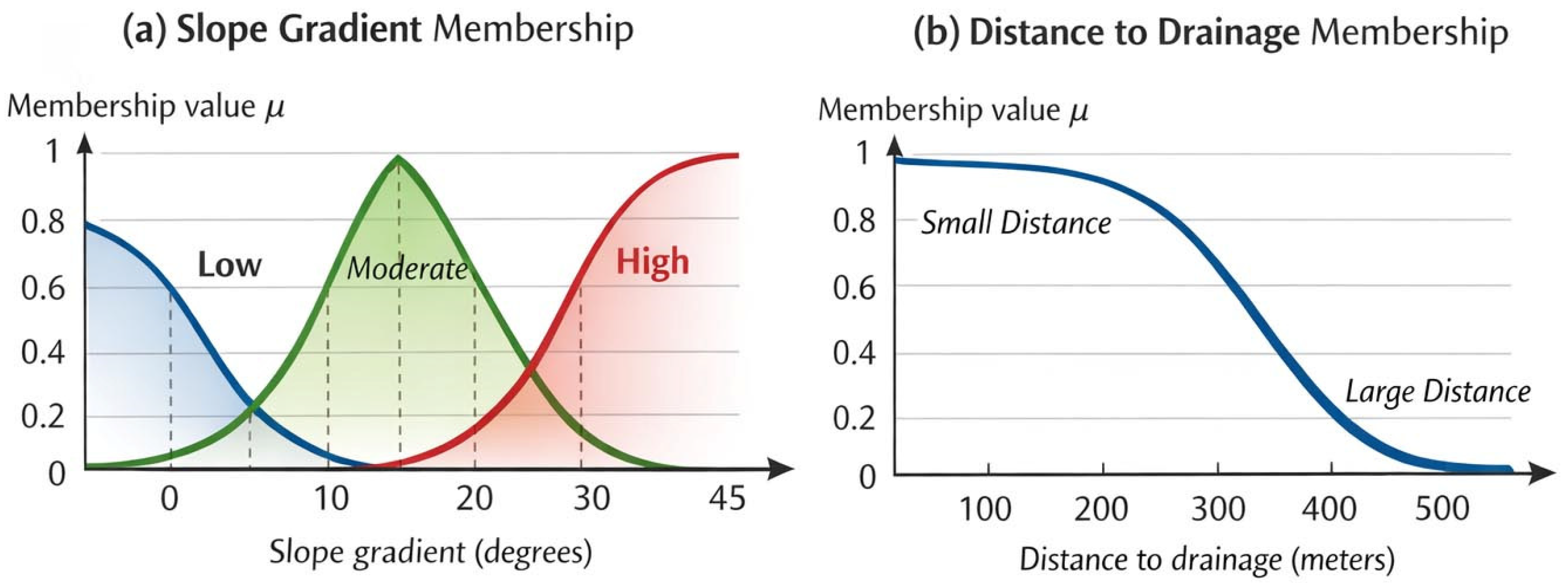
5.2. Fuzzification of Environmental Factors
5.3. Hazard-Specific Fuzzy Inference
5.4. Defuzzification and Continuous Hazard Representation
5.5. Fuzzy Cumulative Aggregation of Geohazards
5.6. Treatment of Uncertainty Within the Assessment Process
5.7. Summary of Methodological Characteristics
- spatially explicit, cell-based implementation in a GIS environment,
- fuzzy representation of environmental factors and hazard activation,
- rule-based inference supporting partial and gradual activation,
- fuzzy aggregation enabling cumulative geohazard interpretation,
- explicit sensitivity to uncertainty consistent with preventive objectives.
6. Spatial Application of the Fuzzy Geohazard Assessment Approach
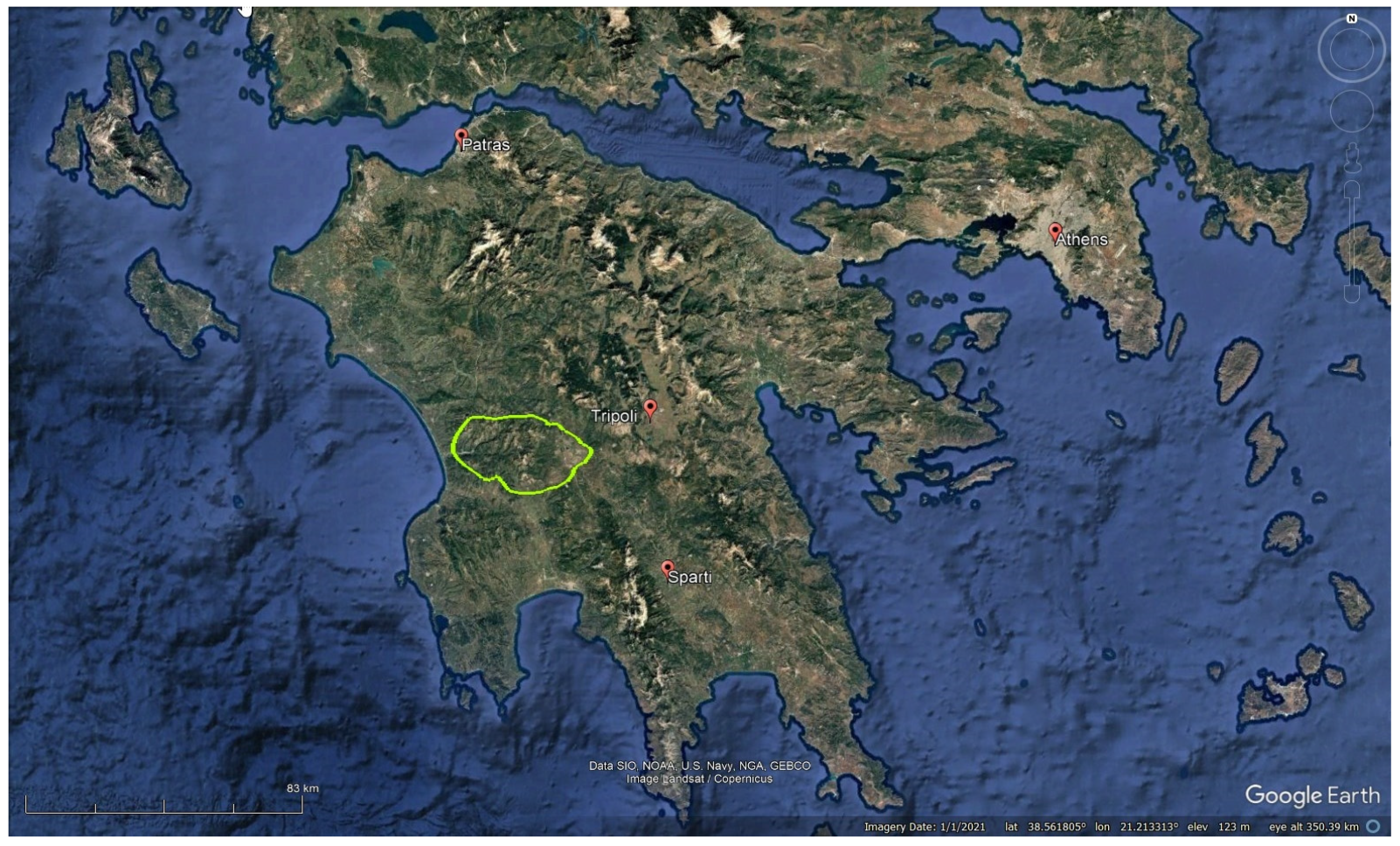
6.1. Study Area and Geographical Setting
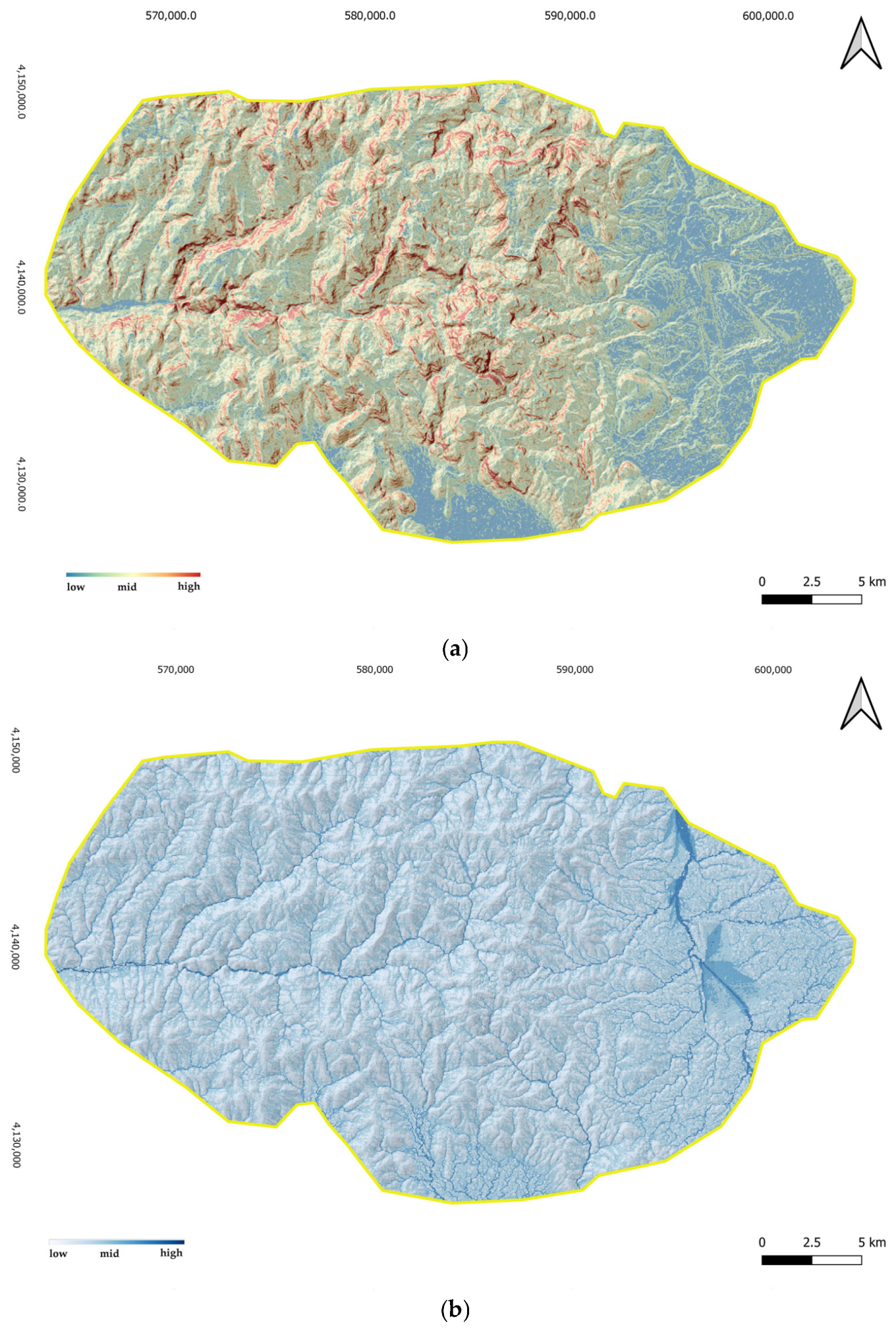
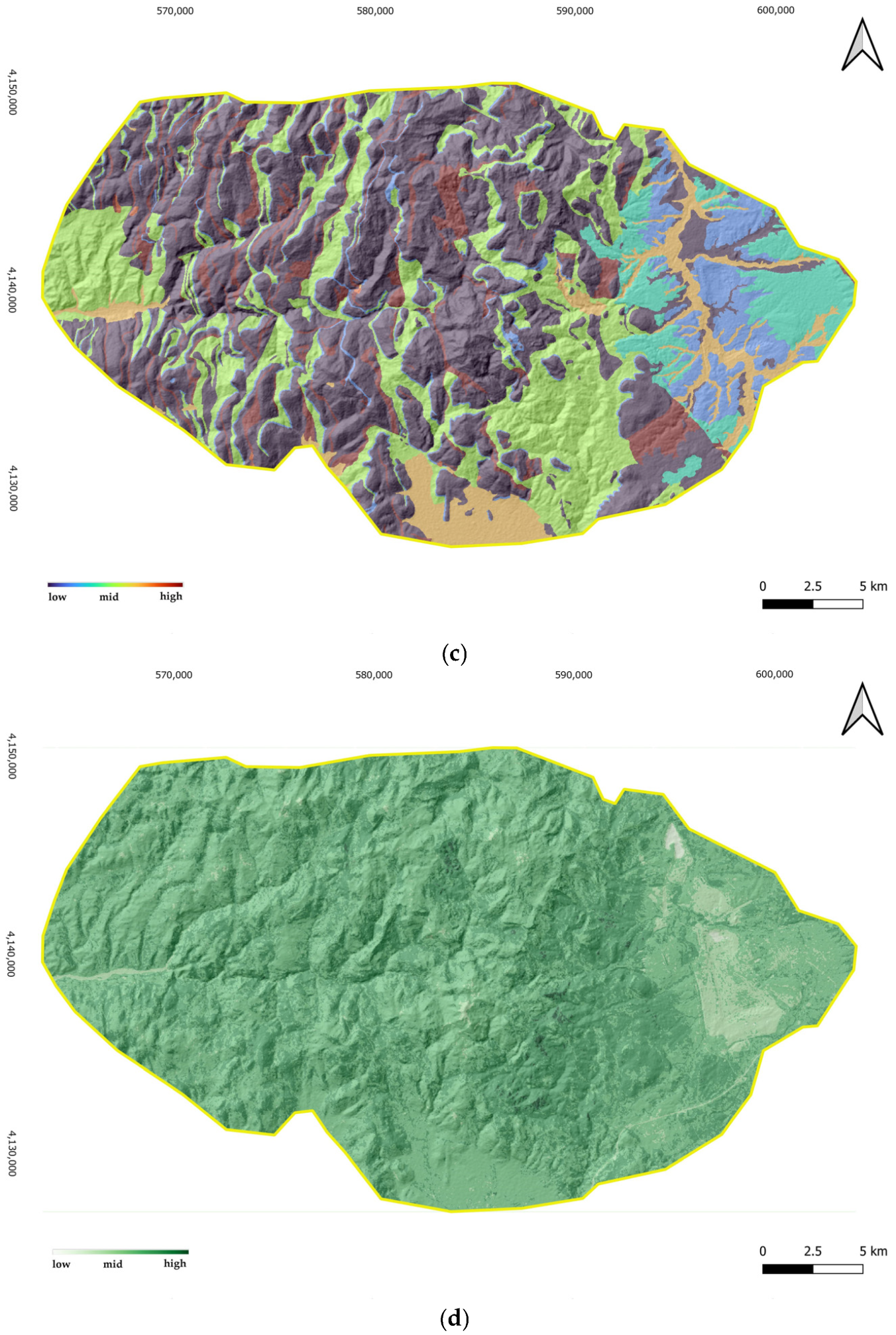
6.2. Environmental Inputs and Spatial Data Preparation
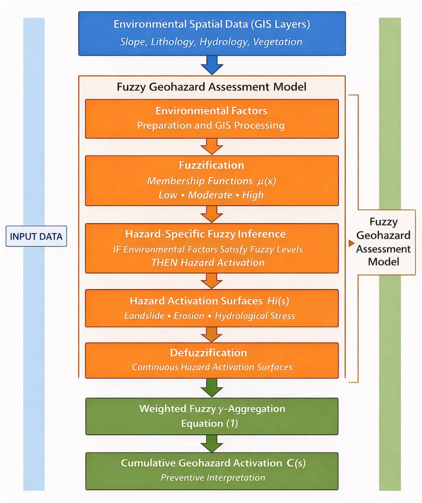
- (1)
- environmental variables are prepared and harmonized as spatial raster inputs;
- (2)
- fuzzification is applied through membership functions to transform variables into graded activation surfaces;
- (3)
- hazard-specific fuzzy inference is performed, and the resulting fuzzy outputs are converted into continuous activation surfaces through centroid defuzzification;
- (4)
- the resulting hazard activation layers are aggregated using the weighted fuzzy γ operator to derive cumulative geohazard activation patterns.
6.2.1. Data Sources and Variable Selection
6.2.2. Spatial Processing and Harmonization
6.2.3. Preparation for Fuzzy Transformation
6.3. Fuzzy Representation and Hazard-Specific Inference
6.3.1. Fuzzy Membership Formulation
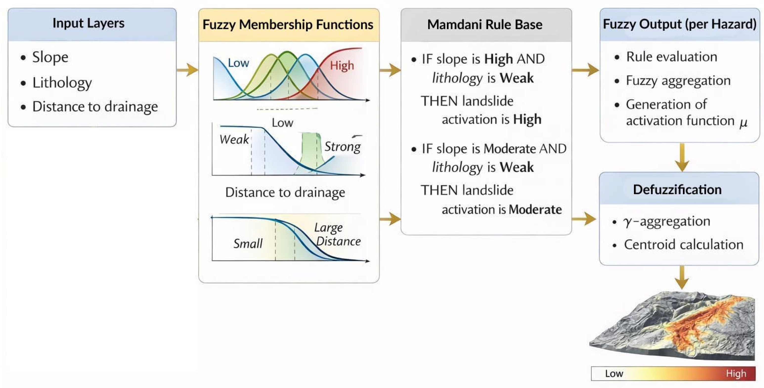
6.3.2. Rule-Based Hazard Inference
- Landslide activation
- Surface erosion activation
- IF slope is High AND lithology is Weak THEN landslide activation is High
- IF slope is Moderate AND lithology is Weak THEN landslide activation is Moderate
- Rules for surface erosion included:
- IF slope is High AND drainage proximity is Small THEN erosion activation is High
- IF slope is Moderate AND land cover is Sparse THEN erosion activation is Moderate
6.3.3. Defuzzification and Hazard Activation Surfaces
6.4. Cumulative γ Aggregation and Spatial Synthesis
6.4.1. Aggregation Setup
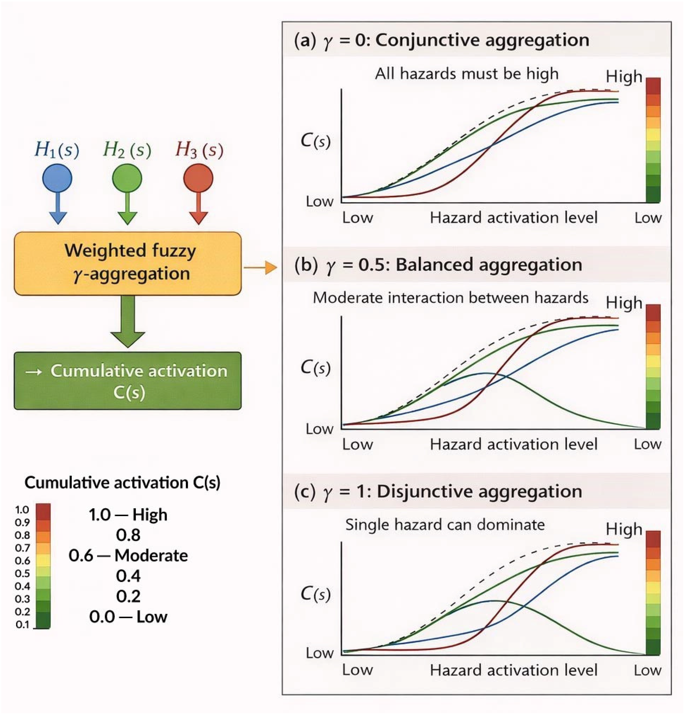
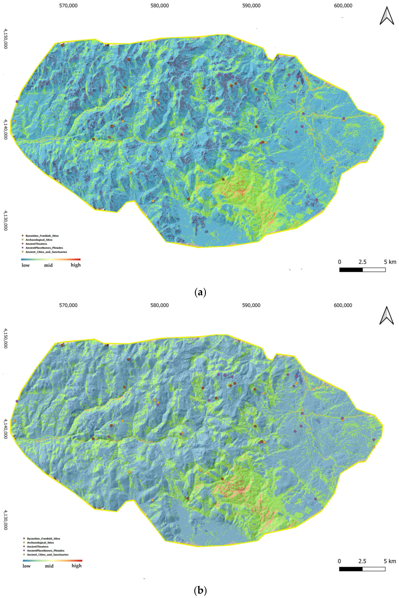
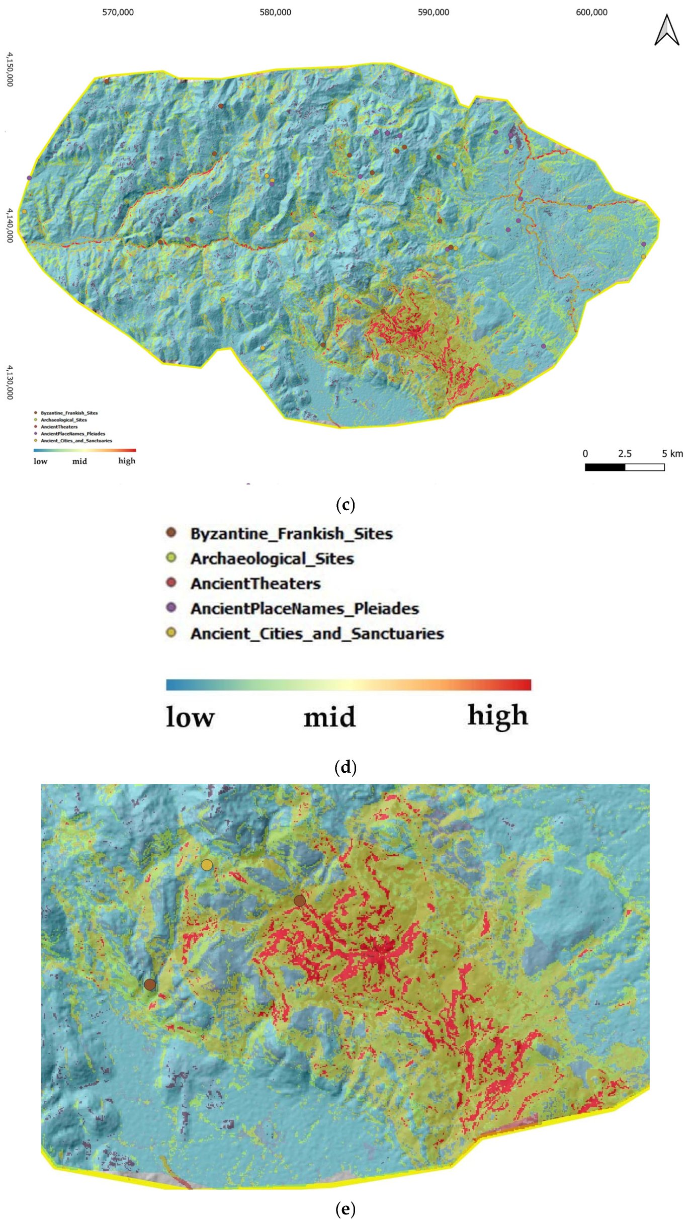
6.4.2. Influence of the Precautionary Parameter
- γ = 0.3 (conjunctive tendency)
- γ = 0.6 (balanced interpolation)
- γ = 0.9 (disjunctive precautionary tendency)
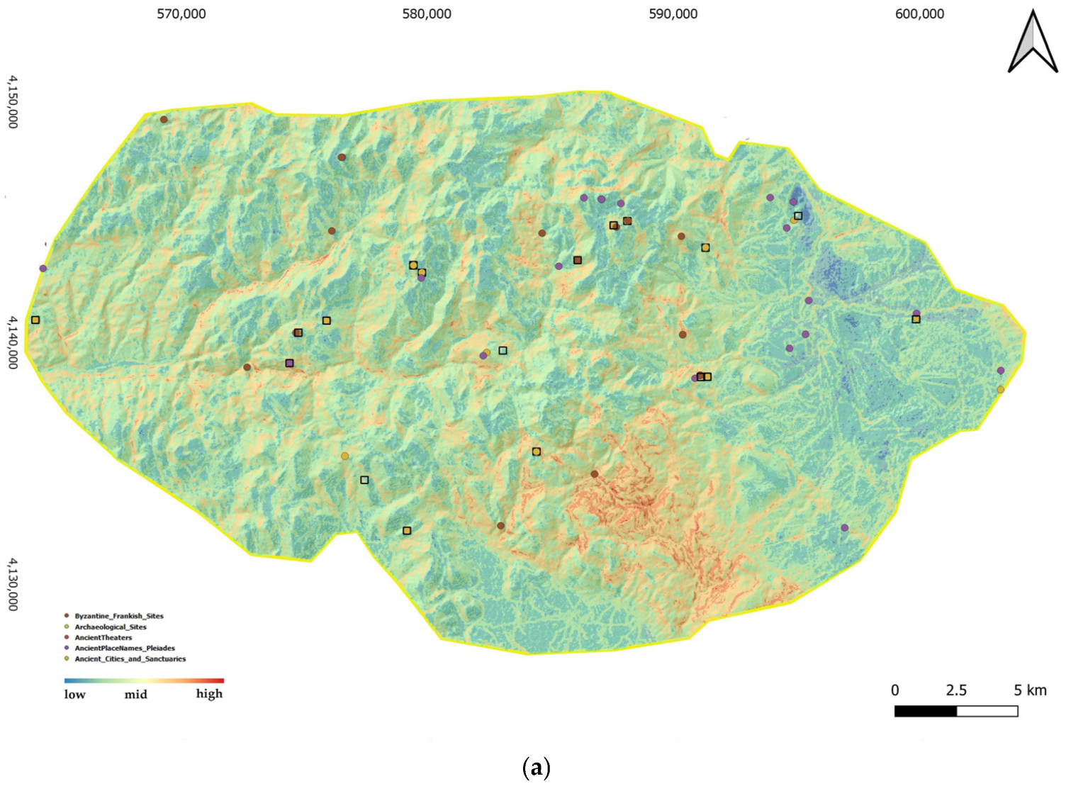
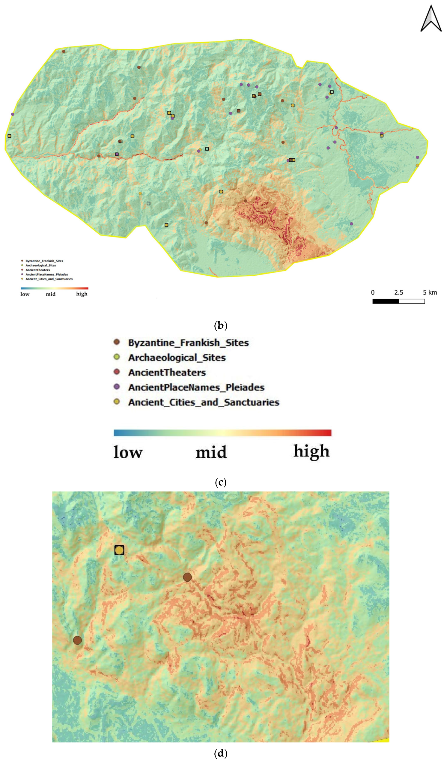
6.4.3. Spatial Differentiation and Preventive Patterns
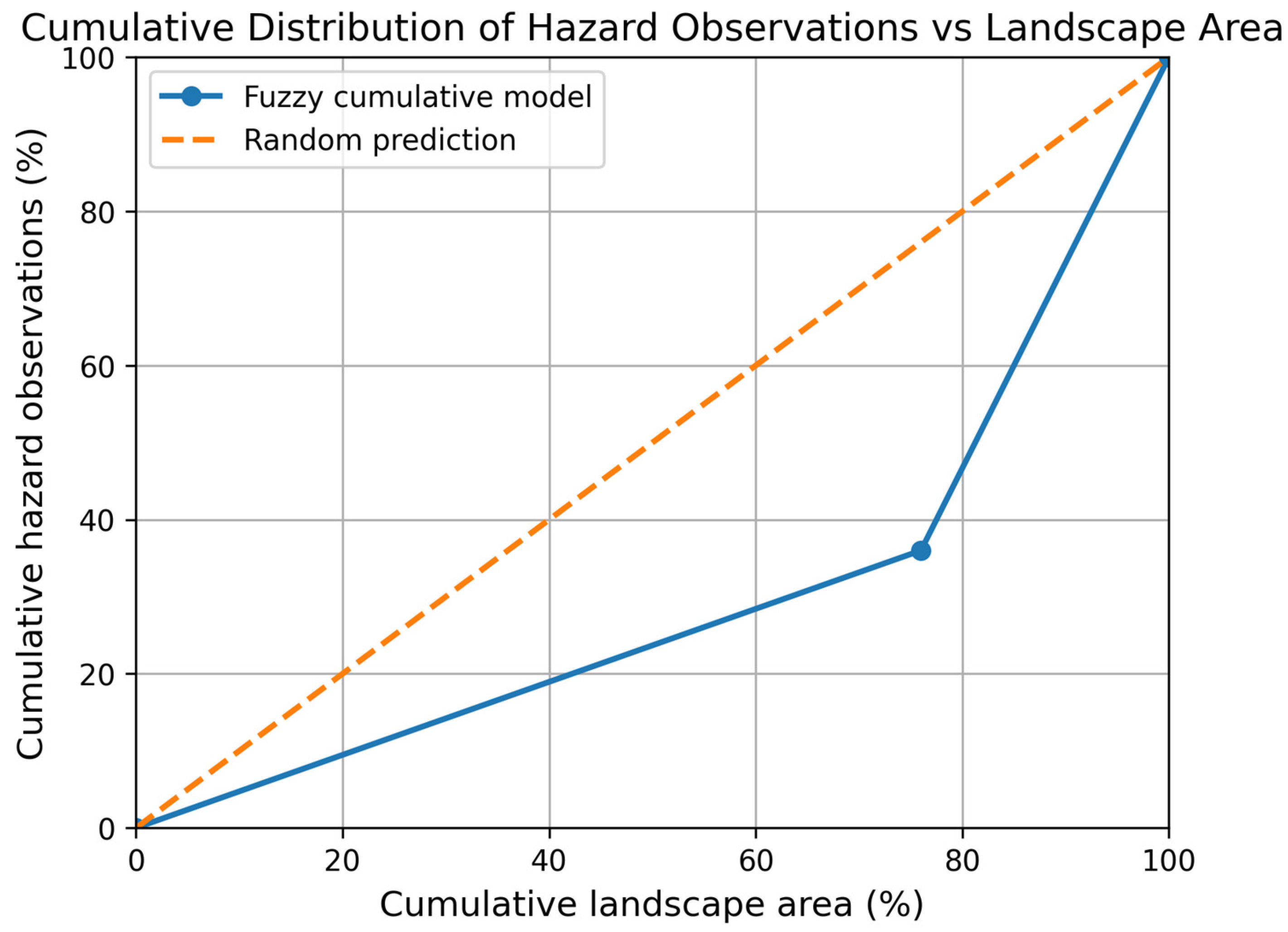
6.4.4. Empirical Spatial Consistency and Discrimination Assessment
7. Discussion
7.1. Methodological Contribution of the Fuzzy Geohazard Assessment Approach
7.2. Precautionary Aggregation and Structured Treatment of Uncertainty
7.3. Spatial Convergence and Preventive Discrimination Capacity
7.4. Robustness, Transparency, and Transferability
7.5. Rethinking Preventive Accuracy in Heritage Geographies
7.6. Implications for Heritage Management, Transferability, and Future Perspectives
8. Conclusions
Funding
Institutional Review Board Statement
Informed Consent Statement
Data Availability Statement
Conflicts of Interest
Abbreviations
| GPI | Geohazard Prevention Index |
| GIS | Geographical Information System |
| QGIS | Quantum Geographic Information System |
| DEM | Digital Elevation Model |
| WGS84 | World Geodetic System 1984 |
| GR29 | Alfios (Alpheios) River Basin |
| GR32 | Neda River Basin |
Appendix A. Mathematical Formulation of the Fuzzy γ Aggregation Operator
Appendix A.1. Definitions and Domain
- s: spatial location (e.g., raster cell).
- Hi(s) ∈ [0, 1]: fuzzy activation degree (membership) of the i-th geohazard at s.
- Wi ≥ 0: weight assigned to the i-th geohazard, typically normalized so that (Equation (A2))
- n: number of geohazards combined.
- γ ∈ [0, 1]: precaution/attitude parameter controlling the balance between conjunctive and disjunctive aggregation.
- C(s) ∈ [0, 1]: fuzzy degree of cumulative geohazard activation, interpreted as preventive concern (not probability).
Appendix A.2. Conjunctive (AND Type) Component
Appendix A.3. Disjunctive (OR Type) Component
Appendix A.4. Role of the γ Parameter (Precautionary Control)
- γ = 0 ⇒ C(s) = A(s) (pure AND type aggregation)
- γ = 1 ⇒ C(s) = B(s) (pure OR type aggregation)
- 0 < γ < 1 ⇒ continuous interpolation between the two
Appendix A.5. Mathematical Properties (Interpretability and Robustness)
- Boundedness: C(s) ∈ [0, 1].
- Monotonicity: increasing any Hi(s) does not decrease C(s).
- Continuity: small changes in Hi(s) or γ yield small changes in C(s), avoiding threshold induced discontinuities.
- No probabilistic assumptions: the operator aggregates fuzzy membership degrees and does not require independence, probability calibration, or event frequencies.
Appendix A.6. Interpretation of C(s)
Appendix A.7. Numerical Illustration (Two Hazards)
- γ = 0 ⇒ C = A = 0.4988
- γ = 0.5 ⇒ C= √(A ∗ B) = 0.5374
- γ = 0.8 ⇒ C= A^0.2 ∗ B^0.8 = 0.5620
- γ = 1 ⇒ C = B = 0.5790
Appendix A.8. Conceptual Summary
Appendix B. Analytical Interpretation of Cumulative Activation Statistics Based on Environmental Class Distributions
Appendix B.1. Environmental Class Distributions

| Variable | Class | Area (%) |
|---|---|---|
| Slope gradient (°) | 0–15 | 50.11 |
| 15–22 | 23.70 | |
| >22 | 26.19 | |
| Distance to drainage (m) | 0–8 | 0.60 |
| 8–40 | 4.48 | |
| >40 | 94.92 | |
| NDVI | 0–0.2 | 5.17 |
| 0.2–0.5 | 92.74 | |
| 0.5–1.0 | 1.93 | |
| Lithological susceptibility | 0–0.3 | 47.98 |
| 0.3–0.6 | 14.15 | |
| 0.6–1.0 | 37.87 |
Appendix B.2. Interpretation of Cumulative Activation Behavior
References
- Eze, E.; Siegmund, A. Next generation core competency gaps for disaster risk management and preparedness in UNESCO designated heritage sites. Sustain. Futures 2024, 8, 100239. [Google Scholar] [CrossRef]
- Adetunji, O.S.; MacKee, J. Frameworks for climate risk management (CRM) in cultural heritage: A systematic review of the state of the art. J. Cult. Herit. Manag. Sustain. Dev. 2023, 16, 125–155. [Google Scholar] [CrossRef]
- Tosan, M.; Maleki, S.; Dastourani, M. Chapter 4—Impacts of climate change on geomorphological processes and hazards using high resolution data derived from unmanned aerial vehicle photogrammetry and terrestrial laser scanning. In Book Quantitative Geomorphology in the Artificial Intelligence Era, Applications of AI for Earth and Environmental Change; Pourghasemi, H.R., Kariminejad, N., Eds.; Elsevier: Amsterdam, The Netherlands, 2025; pp. 91–119. [Google Scholar] [CrossRef]
- Gigović, L.; Pamučar, D.; Bajić, Z.; Drobnjak, S. Application of GIS interval rough AHP methodology for flood hazard mapping in Urban areas. Water 2017, 9, 360. [Google Scholar] [CrossRef]
- Papakonstantinou, G.F.; Papadopoulou, M.P. Geohazard Prevention Framework: Introducing a Cumulative Index in the Context of Management and Protection of Cultural and Natural Heritage Areas. Land 2024, 13, 1239. [Google Scholar] [CrossRef]
- Papakonstantinou, G.F. Mapping Surface Water Pooling Zones and Stream Flow Accumulation Pathways for Vulnerable Populations in Athens: A Geospatial Hydrological Analysis. Geographies 2026, 6, 26. [Google Scholar] [CrossRef]
- Papakonstantinou, G.F. Identifying Extreme Heat and Moisture Zones for Vulnerable Populations in Athens: A Geospatial Analysis. Land 2025, 14, 1375. [Google Scholar] [CrossRef]
- Chelariu, O.E.; Minea, I.; Iațu, C. Geo hazards assessment and land suitability estimation for spatial planning using multi criteria analysis. Heliyon 2023, 9, e18159. [Google Scholar] [CrossRef]
- Zhu, A.X.; Wang, R.; Qiao, J.; Qin, C.Z.; Chen, Y.; Liu, J.; Du, F.; Lin, Y.; Zhu, T. An expert knowledge based approach to landslide susceptibility mapping using GIS and fuzzy logic. Geomorphology 2014, 214, 128–138. [Google Scholar] [CrossRef]
- Ouifak, H.; Idri, A. A comprehensive review of fuzzy logic based interpretability and explainability of machine learning techniques across domains. Neurocomputing 2025, 647, 130602. [Google Scholar] [CrossRef]
- Leonardi, G.; Palamara, R.; Ciriann, F. Landslide Susceptibility Mapping Using a Fuzzy Approach. Procedia Eng. 2016, 161, 380–387. [Google Scholar] [CrossRef]
- Asghari, M.; Maleki, Z.; Solgi, A.; Ganjavian, M.A.; Kianoush, P. Geohazard impact and gas reservoir pressure dynamics in the Zagros Fold Thrust Belt: An environmental perspective. Geosyst. Geoenviron. 2025, 4, 100362. [Google Scholar] [CrossRef]
- Wang, J.; Kang, Y.; Feng, B. Disaster resilience in the geohazard prone mountainous areas: Evidence from the Hengduan Mountain, southwest China. Int. J. Disaster Risk Reduct. 2025, 119, 105331. [Google Scholar] [CrossRef]
- Gordon, W. Chapter 1—Geohazards and communities. In Book Geohazards and Disasters. Modeling Scenarios as a Challenge for the Future; Elsevier: Amsterdam, The Netherlands, 2025; pp. 1–46. [Google Scholar] [CrossRef]
- Ghosh, P.; Lepcha, K. Weighted linear combination method versus grid based overlay operation method—A study for potential soil erosion susceptibility analysis of Malda district (West Bengal) in India. Egypt. J. Remote Sens. Space Sci. 2019, 22, 95–115. [Google Scholar] [CrossRef]
- Dikshit, A.; Pradhan, B.; Alamri, A.M. Pathways and challenges of the application of artificial intelligence to geohazards modelling. Gondwana Res. 2021, 100, 290–301. [Google Scholar] [CrossRef]
- Ayalew, L.; Yamagishi, H. The application of GIS based logistic regression for landslide susceptibility mapping in the Kakuda Yahiko Mountains Central Japan. Geomorphology 2005, 65, 15–31. [Google Scholar] [CrossRef]
- Pradhan, B. Flood Susceptible Mapping and Risk Area Estimation Using Logistic Regression, GIS and Remote Sensing. J. Spat. Hydrol. 2009, 9, 1–18. [Google Scholar]
- Feizizadeh, B.; Roodposhti, M.S.; Jankowski, P.; Blaschke, T. A GIS based extended fuzzy multi criteria evaluation for landslide susceptibility mapping. Comput. Geosci. 2014, 73, 208–221. [Google Scholar] [CrossRef] [PubMed]
- Walker, W.E.; Harremoës, P.; Rotmans, J.; van Asselt, M.B.A.; Janssen, P.; von Krauss, M.P.K. Defining Uncertainty: A Conceptual Basis for Uncertainty Management in Model Based Decision Support. Integr. Assess. 2003, 4, 5–17. [Google Scholar] [CrossRef]
- Zadeh, L.A. Fuzzy sets. Inf. Control 1965, 8, 338–353. [Google Scholar] [CrossRef]
- Abdelalim, M.; El Naggar, H. Urban flood hazard mapping in Dubai’s Hyper Arid environment using a 2D HEC RAS and GIS–MCDA–AHP integrated framework. Total Environ. Adv. 2026, 17, 200141. [Google Scholar] [CrossRef]
- Aven, T. A risk and safety science perspective on the precautionary principle. Saf. Sci. 2023, 165, 106211. [Google Scholar] [CrossRef]
- Jacobs, J.R. The precautionary principle as a provisional instrument in environmental policy: The Montreal Protocol case study. Environ. Sci. Policy 2014, 37, 161–171. [Google Scholar] [CrossRef]
- Klaver, N.R.; Dijkstra, T.A.; Barkwith, A.; Dashwood, C.; De Jong, S.M.; van Beek, R.L.P.H. Mass movement hazard & global climate change: Physical deterministic modeling study of the rest and be thankful pass, Scotland UK. Geomorphology 2023, 446, 108979. [Google Scholar] [CrossRef]
- Gohil, M.; Mehta, D.; Shaikh, M. An integration of geospatial and fuzzy logic techniques for multi hazard mapping. Results Eng. 2024, 21, 101758. [Google Scholar] [CrossRef]
- Azimi, S.R.; Nikraz, H.; Yazdani Chamzini, A. Landslide Risk Assessment by using a New Combination Model based on a Fuzzy Inference System Method. KSCE J. Civ. Eng. 2018, 22, 4263–4271. [Google Scholar] [CrossRef]
- Zimmermann, H.J. Fuzzy Set Theory—And Its Applications; Springer: Dordrecht, The Netherlands, 2001; p. 514. [Google Scholar] [CrossRef]
- Camastra, F.; Ciaramella, A.; Giovannelli, V.; Lener, M.; Rastelli, V.; Staiano, A.; Staiano, G.; Starace, A. A fuzzy decision system for genetically modified plant environmental risk assessment using Mamdani inference. Expert Syst. Appl. 2015, 42, 1710–1716. [Google Scholar] [CrossRef]
- Song, Q.; Leland, R.P. Adaptive learning defuzzification techniques and applications. Fuzzy Sets Syst. 1996, 81, 321–329. [Google Scholar] [CrossRef]
- Jiang, T.; Li, Y. 31-Techniques and Applications of Fuzzy Theory in Generalized Defuzzification Methods and Their Utilization in Parameter Learning Techniques. Fuzzy Theory Syst. Tech. Appl. 1999, 2, 871–895. [Google Scholar] [CrossRef]
- Choudhary, D.; Choudhury, S.; Saha, A.K. A decision making framework with Complex Linear Diophantine Fuzzy Aczel Alsina aggregation operator for real world problem. Eng. Appl. Artif. Intell. 2026, 168, 113930. [Google Scholar] [CrossRef]
- Zimmermann, H.J.; Zysno, P. Latent connectives in human decision making. Fuzzy Sets Syst. 1980, 4, 37–51. [Google Scholar] [CrossRef]
- Klir, G.J.; Yuan, B. Fuzzy Sets and Fuzzy Logic, Theory and Applications; Prentice Hall Inc.: Upper Saddle River, NJ, USA, 1995; p. 574. [Google Scholar]
- Dubois, D.; Prade, H. Fuzzy Sets and Systems: Theory and Applications; Academic Press: Boston, MA, USA, 1980; p. 393. [Google Scholar]
- Parrhasian Heritage Park of the Peloponnesos. Available online: https://www.parrhasianheritagepark.org/ (accessed on 13 March 2026).
- Davis, G. Geology of the Sanctuary of Zeus, Mount Lykaion, Southern Peloponessos, Greece, and Field Guide. J. Virtual Explor. 2019, 33, 1. [Google Scholar] [CrossRef]
- Parthasarathy, T.N.; Athira, T.M.; Bhoopalan, R.; Tirkolaee, E.B. Hybrid fuzzy multi criteria decision making model for assessing sustainable waste management strategies. Expert Syst. Appl. 2026, 318, 131937. [Google Scholar] [CrossRef]
- Altamimi, S.; Fang, L.; Amleh, L. Identifying climatic hazard importance factors for bridges using expert based fuzzy analytic hierarchy process. Int. J. Disaster Risk Reduct. 2025, 133, 105971. [Google Scholar] [CrossRef]
- Brandano, M.G.; Conti, C.; Modica, M.; Urso, G. Mapping cultural heritage sites at risk: A support tool for heritage sites management. J. Urban Manag. 2025, 14, 690–699. [Google Scholar] [CrossRef]
- Li, M.; Okubo, T.; Kim, D.; Lata, S.; Miyazaki, A. Global challenges and insights in disaster risk management at world cultural heritage sites. Prog. Disaster Sci. 2025, 28, 100477. [Google Scholar] [CrossRef]
- Xu, R.; Ma, L.; Song, B.; Cheng, H.; Yang, T.; Song, Y.; He, Y. Geohazard risk assessment model based on deep neural network. Results Eng. 2026, 29, 109029. [Google Scholar] [CrossRef]


| Environmental Variable | Data Source | Spatial Resolution | Processing | Role in Hazard Modeling |
|---|---|---|---|---|
| Digital Elevation Model (DEM) | National Cadastre | 5 m | Slope derivation | Controls slope instability and erosion processes |
| Geological Map | Institute of Geology and Mineral Exploration | Vector → 5 m raster | Lithology classification | Controls material susceptibility to mass movement |
| Hydrographic Network | DEM (Topographic Wetness Index) | Vector | Euclidean distance raster | Proxy for hydrological concentration and fluvial incision |
| NDVI (Landsat 8) | USGS | 30 m → resampled to 5 m | Reclassification to vegetation density | Represents surface protection and vegetation-mediated soil cohesion |
| Variable | Linguistic State | Function Type | Parameter Values | Geomorphological Interpretation |
|---|---|---|---|---|
| Slope (°) | High | Sigmoidal | a = 0.35, b = 22° | Rapid activation above ~20° |
| Slope (°) | Moderate | Triangular | 15–22° (peak 18°) | Transitional instability |
| Distance to drainage (m) | Small | Inverse sigmoidal | a = 0.02, b = 150 m | Increased hydrological concentration |
| Lithology | Weak | Assigned weight | 0–0.3 | Low material resistance |
| Lithology | Moderate | Assigned weight | 0.3–0.6 | Medium susceptibility |
| NDVI | Sparse | Linear decreasing | 0–0.2 vegetation cover | Reduced surface protection |
| Method | Mean C(s) | Std. Deviation | Area with C(s) > 0.6 (%) |
|---|---|---|---|
| Linear aggregation | 0.40 | 0.14 | 13% |
| Fuzzy γ = 0.3 | 0.41 | 0.16 | 15% |
| Fuzzy γ = 0.6 | 0.44 | 0.18 | 24% |
| Fuzzy γ = 0.9 | 0.47 | 0.21 | 35% |
| Cumulative Activation Class (C(s)) | Landscape Area (%) | Hazard Observation Points (n) | Hazard Points (%) |
|---|---|---|---|
| (C(s) ≤ 0.6) | 76% | 16 | 35.6% |
| (C(s) > 0.6) | 24% | 29 | 64.4% |
| Total | 100% | 45 | 100% |
Disclaimer/Publisher’s Note: The statements, opinions and data contained in all publications are solely those of the individual author(s) and contributor(s) and not of MDPI and/or the editor(s). MDPI and/or the editor(s) disclaim responsibility for any injury to people or property resulting from any ideas, methods, instructions or products referred to in the content. |
© 2026 by the author. Licensee MDPI, Basel, Switzerland. This article is an open access article distributed under the terms and conditions of the Creative Commons Attribution (CC BY) license.
Share and Cite
Papakonstantinou, G.F.D. Advancing Geohazard Assessment in Heritage Areas Through Fuzzy Logic. Geographies 2026, 6, 48. https://doi.org/10.3390/geographies6020048
Papakonstantinou GFD. Advancing Geohazard Assessment in Heritage Areas Through Fuzzy Logic. Geographies. 2026; 6(2):48. https://doi.org/10.3390/geographies6020048
Chicago/Turabian StylePapakonstantinou, George Faidon D. 2026. "Advancing Geohazard Assessment in Heritage Areas Through Fuzzy Logic" Geographies 6, no. 2: 48. https://doi.org/10.3390/geographies6020048
APA StylePapakonstantinou, G. F. D. (2026). Advancing Geohazard Assessment in Heritage Areas Through Fuzzy Logic. Geographies, 6(2), 48. https://doi.org/10.3390/geographies6020048