Article

Integrating Disaster Risk Reduction and Climate Adaptation Across Regional, Island, and Municipal Levels: A Systemic Analysis in the Canary Islands


by
Tamara Febles Arévalo
1,2,*,
Jaime Díaz-Pacheco
2,
Pedro Dorta Antequera
2,
Lucía Martínez Quintana
1 and
Abel López-Díez
2
1
Department of Art, City and Territory, University of Las Palmas de Gran Canaria, 35017 Las Palmas de Gran Canaria, Spain
2
Chair of Disaster Risk Reduction and Resilient Cities, University of La Laguna, 38200 Santa Cruz de Tenerife, Spain
*
Author to whom correspondence should be addressed.
Geographies 2026, 6(2), 47; https://doi.org/10.3390/geographies6020047
Submission received: 20 March 2026 / Revised: 23 April 2026 / Accepted: 2 May 2026 / Published: 11 May 2026

Abstract

Disaster risk reduction and management are essential for sustainable development in territories highly exposed and vulnerable to natural hazards. Recent disasters in the Canary Islands have highlighted the importance of proactive preparedness and systemic approaches to risk management, emphasizing the need to better understand existing barriers to disaster risk reduction (DRR). This study develops an analysis of risk governance within the current planning instruments in the Canary Islands, the island of Tenerife, and the municipality of Candelaria. The research examines the integration of DRR across strategic, territorial, urban, and emergency planning at the regional, insular, and municipal levels. The findings identify key challenges and opportunities for integrating DRR within existing planning frameworks, highlighting both the potential and the limitations of current instruments as cross-cutting tools for building more resilient territories. While Tenerife has a relatively solid administrative and planning structure that could support a more systemic vision of risk, sectoral fragmentation and coordination gaps remain. Overall, the study contributes to the ongoing discussion on advancing risk governance from a systemic perspective at the local level. The challenges identified delineate the boundaries and directions for improvement, offering a valuable contribution to the existing body of knowledge.

1. Introduction

Currently, risk governance represents a growing challenge for decision-makers across different levels of government. The ways in which we govern, build, and inhabit territories strongly influences disaster risk reduction (DRR), as disasters are no longer rare events but frequent expressions of systemic risks [1,2,3]. The interdependence among ecological, social, and technical systems constitutes a structural feature of today’s world. Although this interconnectedness can generate benefits and opportunities in terms of efficiency, it can also increase exposure to systemic risks, characterized by complexity, uncertainty, and interrelated effects, thereby posing significant obstacles to risk governance and management [4]. Moreover, the complexity of disaster risk is further amplified by the interaction among hazards [5]. In this context, DRR frameworks have evolved toward a more integrated perspective, promoting a systemic and multi-hazard approach to risk assessment and management that analyzes the interrelationships among hazards, vulnerabilities, and socioeconomic processes [6].
The objective of this study is to analyze risk governance, particularly disaster risks associated with natural hazards, across different spatial scales at the local level, considering the regional, insular, and municipal levels in a case study of the Canary Islands. The aim is to identify barriers and areas of opportunity, based on the analysis of specialized literature, to improve risk governance. In the archipelago, Tenerife is currently implementing risk preparedness measures, supported by existing emergency plans, as well as incorporating the Urban Agenda at the municipal level. In this scenario, Candelaria constitutes an especially relevant case study for several reasons. First, it has been a pioneer in approving the Local Action Plan for the implementation of the Spanish Urban Agenda, becoming the first municipality on the island to formalize this strategic instrument. Second, it is one of the municipalities that have recently approved the Climate and Sustainable Energy Action Plan (PACES). Lastly, its experience in strategic planning processes and in promoting participatory mechanisms with citizens provides significant analytical value for examining how risk governance is being articulated.
The research conducted contributes to efforts to reflect on the implementation of the commitments established in the Sendai Framework for Disaster Risk Reduction 2015–2030 [3] in local contexts. In particular, it aims to advance the understanding of risk governance through systemic and integrated approaches, bringing together diverse perspectives and identifying the main obstacles and opportunities for improvement. This is the first study to analyze this governance framework for DRR through strategic, territorial, and civil protection planning across three levels of government in the archipelago. To carry out this work, the main theoretical concepts supporting the analysis have been contextualized, and the archipelago and municipality are geographically situated. Based on this conceptual framework, the methodology employed is presented, along with the analytical matrix designed to delve into the case study. Finally, the results of the analysis are presented, followed by a discussion aimed at identifying the main barriers and prospects. The challenges and opportunities identified also highlight the areas and directions in which improvements are needed to strengthen risk governance.

1.1. Risk Governance

Risk governance can be understood as the interaction of processes, structures, and actors involved in decision-making [7,8]. It also refers to the processes through which collective goals are established and pursued, where the state is not the only participant [8,9]. Adopting a governance perspective implies recognizing the complexity of interactions and the diverse roles that participate in these processes. Although there are institutional, technical, and legislative mechanisms, as well as frameworks and measures aimed at DRR, their implementation depends on structures and dynamics inherent to governance [10,11]. The capacity to implement these measures collectively and in a coordinated manner across different levels—global, national, and local—is a key factor influencing the efficiency and effectiveness of DRR efforts, contributing significantly to reducing loss of life, the number of people affected, and both direct and indirect impacts.
Over the past two decades, governance in DRR has gained particular relevance with the adoption of the Hyogo Framework for Action by the United Nations International Strategy for Disaster Reduction (2005). Furthermore, the analysis conducted by Nuñez and Ocampo-Salazar [12] shows that risk governance has been approached from various theoretical frameworks, ranging from systems theory and complex adaptive systems [4] to perspectives rooted in political philosophy [13]. According to Wilkinson [7], drawing on contributions by Biermann [14], the literature on earth system governance emphasizes the adaptability of governance mechanisms and processes, as well as legitimacy, accountability, and modes of allocation and access, highlighting social aspects and the political dimension related to resource distribution. It represents the institutional structure and the processes that guide and condition collective action to regulate, mitigate, or control disaster risk [15]. Therefore, risk management or emergency preparedness is considered only one component of risk governance.
Thus, understanding risk governance in complex systems represents a major challenge. From the field of environmental governance and at a more abstract level, Pahl-Wostl [16] identifies four key characteristics for disaster risk governance. Her approach focuses on the domains of politics and public policy, emphasizing both the institutional arrangements that structure collective action—whether formal or informal, state or non-state, centralized or local—and the different modes of policymaking, such as hierarchies, markets, and networks [7]. With the aim of addressing the complexity of these systems and drawing on the approach proposed by Pahl-Wostl [16] as well as Wilkinson’s [7] adaptation, three analytical dimensions are identified for case study analysis: (1) formal and informal institutions; (2) actors and networks; and (3) multilevel interactions.

1.2. Systemic Risk Perspective and Governance

The concept of systemic risk thus refers to threats that generate widespread impacts, cut across different sectors, or may unfold across multiple scales (local, regional, global), going beyond traditional risk management [4,17]. It is considered a cross-cutting phenomenon encompassing multiple operational and strategic domains. The literature and international frameworks suggest that improvements in mitigation, response, and recovery could be achieved if the approach centered exclusively on individual hazards is overcome [18,19,20].
The International Risk Governance Council (IRGC) defines risk governance as “the actions, processes, traditions and institutions by which authority is exercised and decisions are taken and implemented. Risk governance applies the principles of good governance to the identification, assessment, management and communication of risks” [21]. It encompasses all actors, rules, conventions, processes, and mechanisms related to the collection, analysis, evaluation, and communication of relevant risk information, as well as how risk management decisions are made [22]. Operationalizing the concept of systemic risks within tools and instruments for their governance is particularly complex, given that current political and administrative systems do not facilitate addressing complex problems from a coordinated, holistic perspective. The literature and current frameworks emphasize the importance of coordination and cooperation among organizations and entities, promoting joint participation in guiding or governing transitions toward new models that allow adaptation to contextual conditions or the transformation of the system itself [22,23].
According to Wilkinson [7], political and institutional change processes may be better understood from the perspective of adaptation. In the climate change literature, the concept of adaptation has been used “to refer to the ability of a unit to transform its structure, functioning, or organization in response to actual or expected levels of risk, hazard, and/or vulnerability thresholds” [7]. Climate change adaptation is described as “the process of adjustment to current or expected climate and its effects, in order to moderate harm or take advantage of beneficial opportunities” [24]. In this sense, the concept of adaptation refers to forms of collective action in which the involved parties learn about climate risks and improve their management, being closely linked to the concept of disaster risk governance [7]. Enhancing the adaptive capacity [25] of groups and actors in DRM requires continuous learning processes and flexible planning, prepared to be revised as new knowledge becomes available [26,27]. Organizational resilience, in turn, is defined as “the ability of an organization to anticipate, prepare for, and respond to and adapt to incremental change and sudden disruptions in order to survive and prosper” [28].
All of these concepts point to the need to develop dynamic flexibility that contributes to DRR [20]. Disaster risk governance deals with how institutions change, adapt, and transform, or how they remain static over extended periods, creating constraints or opportunities for DRR and management [7]. Institutional learning—here referring to learning that results in formalized or organized changes in practices—is not linear; it can occur at different governance scales and through learning loops. Field et al. [29] differentiate according to the extent to which learning promotes transformative change [7]. The concepts of learning loops and institutional change provide useful analytical frameworks for understanding and evaluating changes in disaster risk governance: single-loop learning focuses on changes in actions; double-loop learning examines the risk management system and reformulates the approach; and triple-loop learning requires changes in decision-making processes [7,16]. Considering the disaster risk cycle—preparedness, response, and recovery and reconstruction [30]—it is important to highlight that the analysis developed in this study focuses on a pre-crisis phase (even though there have been previous and recent crises in the Canary Islands), taking into account existing planning.

1.3. Geographic Context

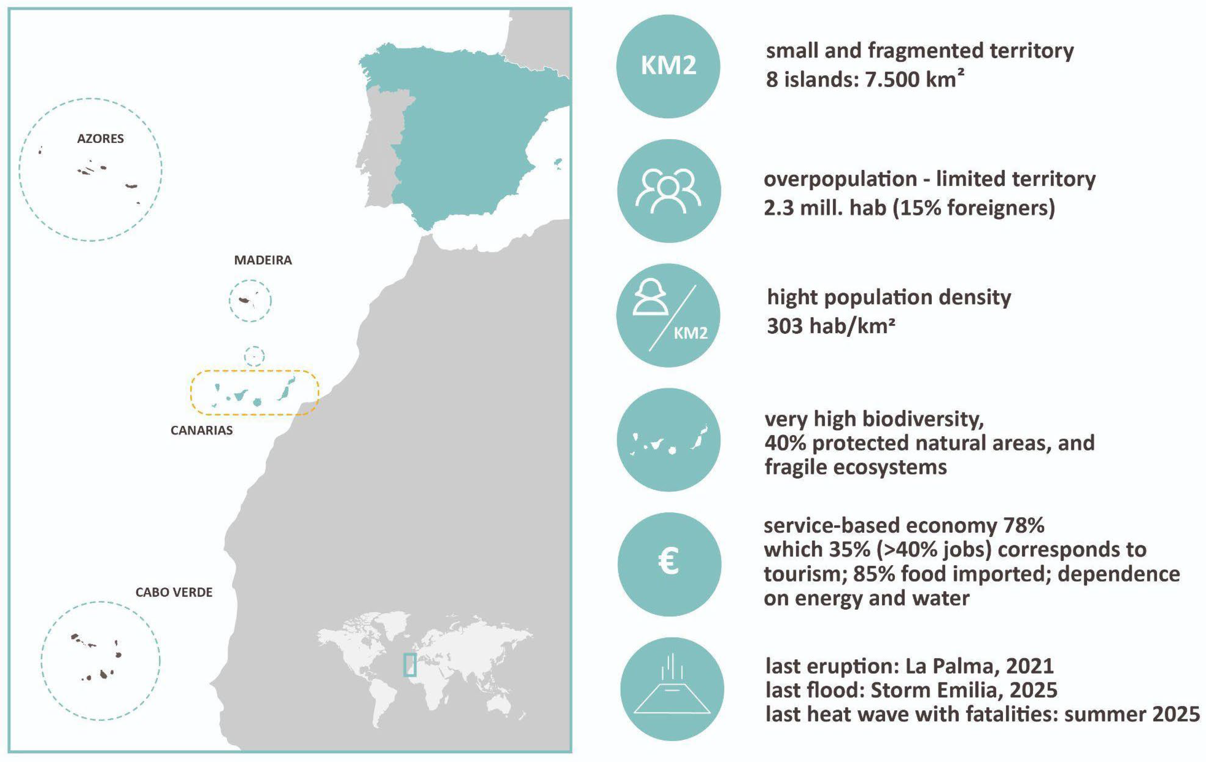
The Canary Islands (Spain) form a volcanic archipelago located in the Atlantic Ocean, 96 km off the northwest coast of Africa (Figure 1). The geological formation and evolution of the archipelago are similar to those of other oceanic volcanic islands situated on a lithospheric plate, such as Hawaii or Réunion [31]. Moreover, in an international context, the Canary Islands are among the most volcanically active regions with the highest proportion of the population exposed to volcanic hazards. This percentage approaches 80%, placing it above countries such as Nicaragua, Guatemala, or Costa Rica [32]. In the national geographic context, the Canary Islands are the only volcanically active region. In addition to geological and geomorphological risks—such as volcanic hazards, seismic activity, landslides, and erosion—there are also forest fires; climatological risks [33,34], as the islands are not exempt from extreme atmospheric events, with vulnerability increasing year by year; anthropogenic risks, such as shortages of basic supplies; and technological risks, such as hazardous materials accidents.
The insular context represents an ideal case of study for investigating and implementing innovative models for risk reduction. The islands concentrate, in a compact form, the needs and challenges that typically affect larger territories, being areas where multiple realities converge, strongly conditioned by prevailing economic and social structures [35]. Furthermore, although the insular condition entails the need to develop and manage autonomous systems for water, waste, energy, or connectivity infrastructure—which increases exposure to internal system failures—they are also particularly vulnerable to systemic risks due to high dependence on external resources and services.
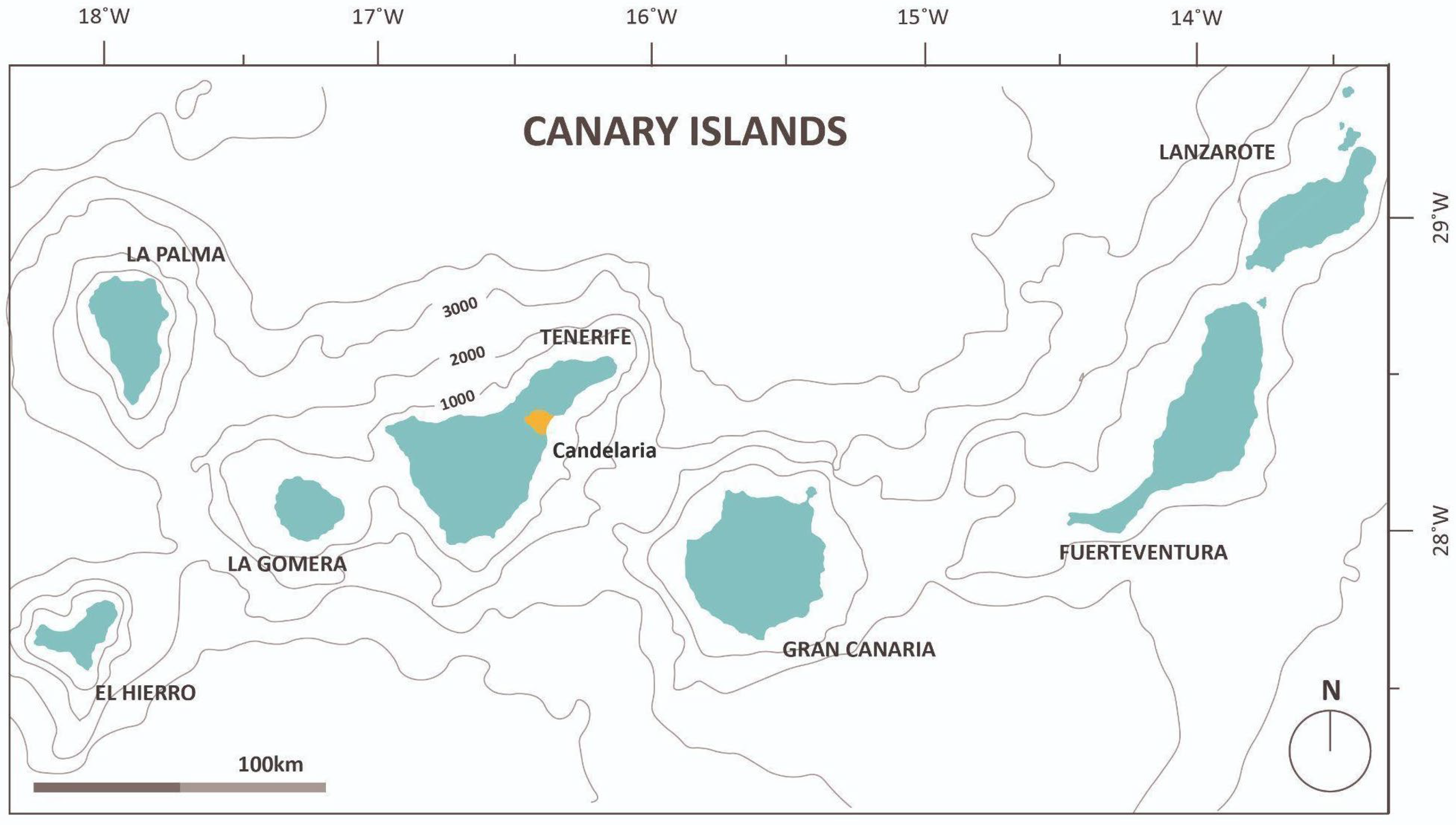
Tenerife is divided into 31 municipalities. The municipality of Candelaria, belonging to the province of Santa Cruz de Tenerife, is located in the southeastern part of the island, in a strategic position between the capital and the south, the area with the highest level of tourism development (Figure 2). The islands encompass highly interconnected risks across interdependent and complex territories and sectors. In addition, the municipality of Candelaria is currently a municipality in Tenerife that features diverse planning instruments that allow for in-depth analysis of the objectives of this research.
In 2019, Candelaria had approximately 28,383 inhabitants [36], approaching 29,000 in 2025 [37], and has experienced demographic growth higher than that of the rest of the island and the archipelago over the past two decades, particularly in the coastal area, which records an annual increase of 5.47% compared to 2.51% in the mid-altitudes [38]. This growth has been accompanied by displacement of the original population. The territorial organization is also characterized by a significant division between the coastal strip (0–300 m) and the mid-altitudes (500–800 m).

1.4. Principal Events in the Canary Islands

The geographic, geological, and climatic context of the Canary Islands archipelago exposes it to a wide variety of natural hazards, both of geological–geomorphological origin—such as volcanoes, earthquakes, and slope movements—and climatic hazards, including floods, droughts, wildfires, and heatwaves [39]. From a geological perspective, volcanic risk constitutes the most significant threat, mainly due to the high level of exposure, particularly on islands such as Tenerife and La Palma, where extensive human settlements are located on active volcanic systems [40]. Historically, the long recurrence intervals of eruptions have contributed to a low social perception of volcanic risk, despite the fact that at least 17 eruptions have been recorded since 1400 in Tenerife, La Palma, Lanzarote, and El Hierro [41].
The recent eruption of Tajogaite in La Palma (2021) demonstrated the high destructive potential of volcanism in the archipelago. Although such events generally result in limited mortality [42], they can produce very severe impacts on infrastructure, livelihoods, and human settlements [43], highlighting the high vulnerability of the archipelago. Seismicity in the Canary Islands is primarily of seismo-volcanic origin. The most significant event since the start of instrumental records occurred in 1989, with a magnitude of 5.2 and an intensity of V, affected Santa Cruz de Tenerife. However, the seismic catalog of the Instituto Geográfico Nacional (IGN) records a maximum magnitude of 5.9 in 1949, coinciding with the Duraznero eruption in La Palma [35]. Furthermore, large landslides have been documented throughout the geological history of the archipelago. Slope dynamics are generally expressed mainly through rockfalls [44], which typically affect highly localized areas but can cause significant infrastructure problems, sometimes resulting in the isolation of settlements.
Climate-related risks, in turn, represent a significant threat to both the environment and the socioeconomic structure [33]. Floods, in particular, stand out due to their high recurrence and impact in the Canary Islands. Episodes of intense rainfall, together with associated floods and slope movements, have caused substantial human and economic losses. The most significant flood events in the Canary Islands are those that have affected urban and tourist areas, including the 1957 floods in La Palma, February 1989 in Gran Canaria, and the March 2002 and February 2010 events in Tenerife, which resulted in major human and material damage [33,39]. Tenerife is the island that has suffered the greatest losses from flooding [45]. Furthermore, storm surges and atypical cyclonic storms, along with floods, are among the adverse meteorological events that have caused the highest economic losses in the archipelago.
In the case of coastal hazards, the increase in exposure and vulnerability due to the rapid occupation of the coastline driven by the tourism–real estate economic model [46] has resulted in a significant rise in coastal damage from storm surges, which have been extensively studied [47,48]. Additionally, tropical-origin phenomena can also cause severe impacts, including fluvial and coastal flooding and strong wind gusts. Notable recent events include Storm Delta in 2005 and Hermine in 2022. Storm Delta, in particular, reached wind gusts of 248 km/h at the summits of Tenerife [39] and caused estimated losses of €88 million, mainly due to severe damage to transport infrastructure and essential service networks [49]. Windstorms have also resulted in significant losses, such as the January 1999 storm, which caused estimated damages of €156 million [33]. It is worth noting that, in the context of climate change, the frequency of such events is expected to increase in the Canary Islands [50].
Another climate-related hazard with significant effects and high frequency is meteorological drought. There are numerous historical records, and studies suggest that there are approximately fifteen droughts per century. The longest drought period in the last 50 years occurred from February 1974 to December 1977 [51]. In recent decades, the southern part of the Canary Islands has experienced a significant increase in drought intensity, driven by decreasing precipitation and rising maximum and minimum temperatures. This phenomenon has produced adverse effects on ecosystems and human activities, increasing the risk of wildfires, aggravating water scarcity for irrigation, and affecting agricultural and livestock production [51]. Furthermore, there has been an increase in the intensity, duration, and seasonality of extreme heat events in the Canary Islands. A recent example is the heatwave in October 2023, which lasted 14 days and recorded a temperature anomaly of 3.6 °C above the average [52]. These events have significant impacts on ecosystems and human health, and also act as a key factor in the occurrence of large wildfires (GIFs) [53].
The occurrence of GIFs is closely linked to adverse weather conditions, such as high temperatures, low relative humidity, and strong winds, combined with the high fuel load present on the islands. Between 2012 and 2024, a total of 13 GIFs were recorded in Tenerife, Gran Canaria, La Palma, and La Gomera, affecting 7.4% of the total land area of the islands and leading to the evacuation of more than 43,000 people [53]. In addition, Saharan air intrusions primarily affect respiratory health and air transport operations, with the February 2020 event being particularly significant, as it resulted in the closure of air traffic across the entire archipelago [54].
In the specific case of the municipality of Candelaria, the official municipal website has provided information on Safety and Emergency Management since 2019. The first activation of the Municipal Emergency Plan (PEMU) occurred in July 2020. In recent years, the PEMU has had to be activated due to coastal events, strong winds, torrential rainfall, storms, floods, high temperatures, heat waves, wildfires, and coastal pollution. Among the most significant events and incidents associated with these activations are the collapse of walls and electricity poles in March 2022 due to strong winds [55], as well as the overflow of sewage systems, interruptions in public lighting, and flooding of some individual homes caused by rainfall in September of the same year [56]. Additionally, the 2023 wildfire [57] is notable, which required the evacuation of more than 26,000 people across the eleven affected municipalities on the island, and the 2024 coastal floods caused by a severe marine storm, which led to the evacuation of 40 people along the coast of Tenerife [58].

2. Material and Methods

This research is conducted using a qualitative-comparative documentary analysis design, aimed at systematically examining risk governance, taking into account the integration of DRR as well as climate change adaptation and mitigation measures in the current instruments of the Autonomous Community of the Canary Islands, Tenerife, and Candelaria. The methodological approach combines a systematic review adapted to the PRISMA 2020 model [59] with a structured content analysis and a comparative analysis of the results.
This study integrates: (1) the analysis of existing conceptual frameworks and methodological references for the development of the analytical matrix; (2) the development of the matrix; (3) the selection of the instruments to be analyzed; and (4) the content analysis using the designed evaluation framework, alongside a comparative analysis of results according to the type of planning examined.

2.1. Analysis of Conceptual Frameworks and Development of the Evaluation Matrix

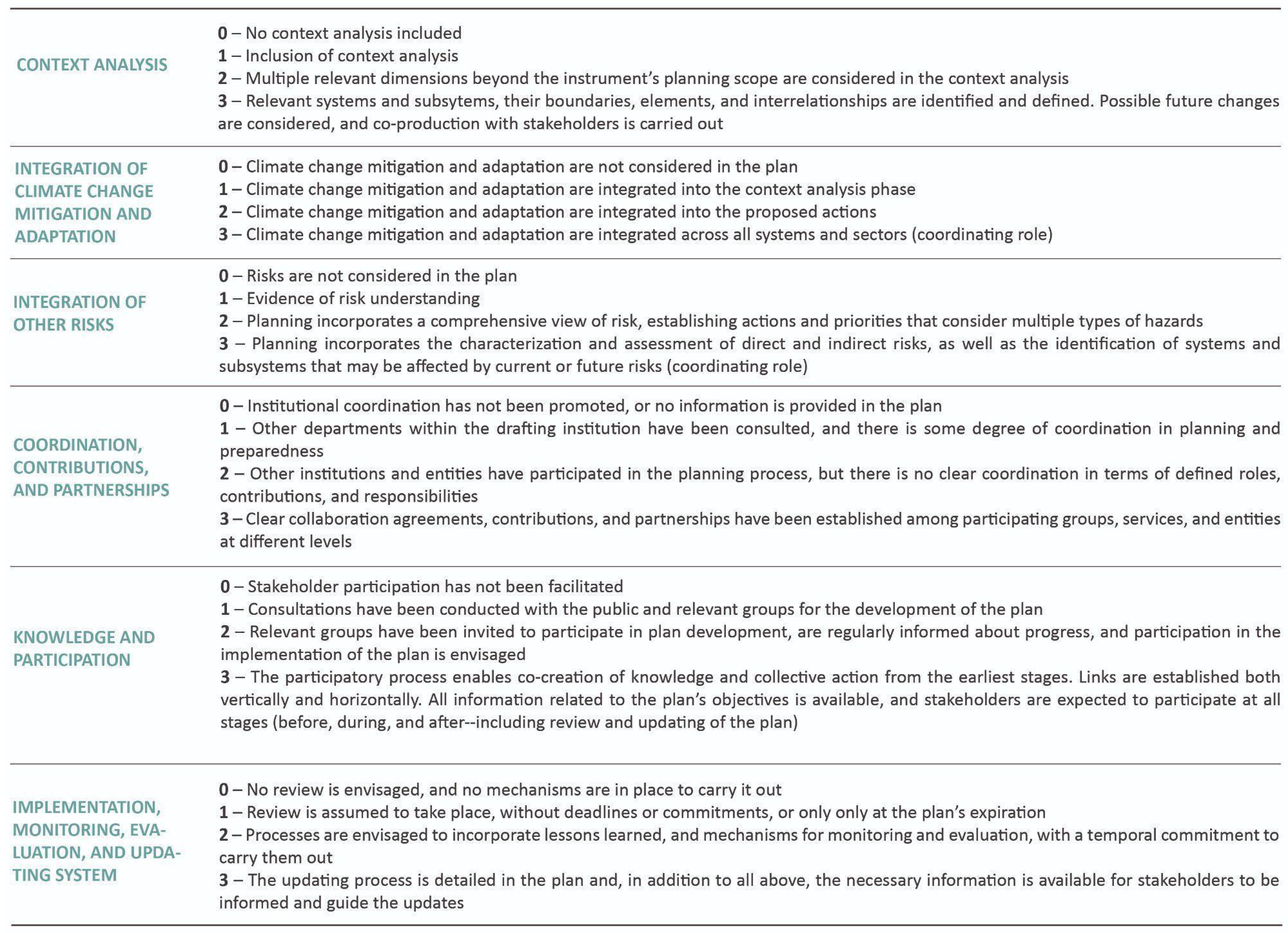
The qualitative content analysis is supported by a structured evaluation tool, developed based on existing conceptual frameworks and methodological references. The analytical tool designed (Figure 3) incorporates a scoring system based on: (A) the Disaster Resilience Scorecard for Cities by the United Nations Office for Disaster Risk Reduction (2017) [60], developed to support local-level implementation and reporting of the Sendai Framework and structured around the Ten Essentials for Making Cities Resilient; (B) the IRGC Guidelines for the Governance of Systemic Risks (2018) [22]; and (C) the frameworks proposed by Hochrainer-Stigler et al. [6] and Mitra and Shaw [4].
In this analysis of risk governance, the specific objectives are: (1) to identify the degree of incorporation of a systemic perspective in the existing instruments, particularly in the context analysis from which they derive—explore the system in IRGC [22]; the whole system approach in Mitra and Shaw [4]; and the system definition in Hochrainer-Stigler et al. [6]—considering the inclusion of future scenarios and the development of knowledge co-creation processes among the involved stakeholders [4,6,34]; (2) to analyze the extent to which DRR and climate change adaptation and mitigation are integrated into planning, taking into account the presence of instruments with policy coordination capacity; (3) to examine the level of institutional coordination, collaborative mechanisms, and shared responsibilities recognized in the frameworks as fundamental aspects for DRR [60]; (4) to identify knowledge-generation processes, information sharing, and stakeholder participation, including both governmental actors and local communities [6,22,60]; and (5) to analyze the existence of implementation mechanisms and the incorporation of institutional learning [7], emphasizing the integration of feedback loops and continuous learning as key elements of resilience [4]—Step 7 in IRGC [22], and the repeated need to update information on hazards, vulnerabilities, and risk data in the Disaster Resilience Scorecard [34].
The proposed matrix addresses these objectives by establishing analytical categories. The first category considered is the context analysis adopted by each instrument. Next, the degree of integration of climate change adaptation and mitigation is examined, along with the incorporation of risk reduction as key elements in planning, strategy formulation, action definition, or the implementation of measures. Likewise, the level of institutional articulation as well as the participation of relevant stakeholders is analyzed. Finally, the existence and implementation of mechanisms for monitoring, evaluation, and updating the instruments are assessed, taking into account the need for their adaptability to changing contexts. In this way, the matrix includes six analytical categories (Figure 3).
The scoring system is based on a matrix of criteria and levels (0–3), defined according to the ideal situation identified in the previously reviewed literature. Within this scale, a score of 0 represents the least favorable scenario, while a score of 3 corresponds to the optimal condition, enabling a systematic assessment of strengths and gaps in the analyzed instruments.

2.2. Information Sources and Instruments Selection

Unlike traditional literature reviews, the instruments analyzed in this study are not sourced from academic databases but instead form part of the regulatory and planning framework established by the autonomous legislation of the Canary Islands and by international frameworks. The PRISMA 2020 guidelines were applied to guide the identification, selection, and justification of the corpus. The selection process was conducted following the subsequent phases.
First, during the identification phase, all current instruments related to strategic planning, territorial and urban planning, and emergency planning at the regional, insular, and municipal levels were considered (234 instruments). This initial phase included legislation, regulations, programs, operating rules of various bodies, guidelines, and other instruments linked to civil protection, territorial and environmental policy, as well as existing strategic frameworks across different scales. Identification was carried out through a review of the institutional web portals of the Government of the Canary Islands, the Island Council of Tenerife, and the City Council of Candelaria (last accessed in March 2026). The main difficulty was associated with the dispersion of information, particularly regarding strategic planning at the regional level, which is not centralized in the Government of the Canary Islands’ regulatory and legal directory. This required conducting targeted searches across individual departments. Additionally, issues with the updating of some institutional repositories were identified, as in certain cases, they still include instruments that are no longer in force.
Second, during the screening phase, a review of the objectives and competencies of each instrument was conducted, along with an assessment of their current validity. This process enabled the exclusion of regulations, legal provisions, programs, or guidelines of a highly specialized nature, focused on specific security forces, emergency services, or narrowly defined sectoral domains—such as police disciplinary and conduct regulations or rules governing the creation and operation of specific technical committees. Additionally, the plans for Protected Natural Areas in Tenerife (42 instruments) were excluded, as the need for a dedicated analysis of this set was identified, whereas the present study, with regard to spatial planning, focuses on insular structural planning and detailed planning at the municipal scale (3 instruments). As a result of this phase, the number of instruments was reduced to less than half of those initially identified (39 instruments), with a total of 195 instruments excluded.
Subsequently, a full review of the remaining instruments (39) was carried out, analyzing the regulatory framework related to emergency management, spatial planning, and cross-cutting strategic frameworks. Finally, although part of the key legislation is included in the study for the purpose of contextualizing the regulatory framework (Table A1 and Table A2 in Appendix A or Section 3.2.3 and Section 3.3), these fifteen instruments (laws, regulations, and guidelines) were excluded from the applied analysis using the designed matrix, as they are not considered planning instruments. Accordingly, the final corpus consisted of 24 planning instruments, as presented in Table A3, Table A4 and Table A5 of Appendix A.

2.3. Analysis Procedure

Once the planning instruments were selected, they were analyzed using the designed matrix, focusing exclusively on the content of the plans. In this regard, the analysis did not assess whether the proposed spatial planning framework effectively promotes climate change adaptation or DRR, but rather whether these aspects are explicitly addressed, either in the contextual analysis or in the planning provisions. To this end, it was necessary for the authors of this study to read and analyze each instrument individually. Within this framework, the matrix was designed to minimize bias, providing an approach to risk governance based on the analytical categories defined in the matrix.
The analysis begins with an examination of each instrument’s objectives, scope, and table of contents. Subsequently, content related to each of the analytical categories included in the matrix was identified. In this way, content deemed not relevant for analysis was excluded. In the case of strategic planning, the excluded content mainly relates to the budgetary framework. In emergency planning, content related to the operational aspects of the plan was excluded. Finally, in spatial planning and urban planning, only content related to the implementation program that develops, organizes, and prioritizes actions derived from planning was excluded.
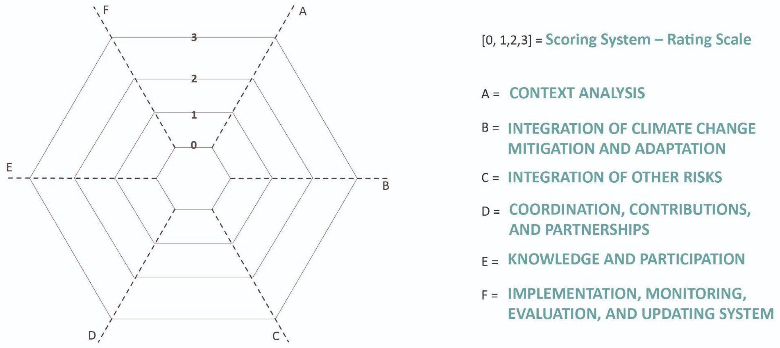
Once this analysis was completed (Table A3, Table A4 and Table A5 in Appendix A), and with the aim of drawing conclusions, a comparative analysis was conducted across the three categories examined—strategic planning, spatial planning, and emergency planning—considering both differences and convergences as well as vertical coherence across scales. To facilitate this comparative analysis, the following analytical diagrams were developed, establishing an average that supports the main conclusions for each category of instruments analyzed (Figure 4).

3. Results

The results are organized as follows: (1) an outline of the institutional structure; (2) an examination of the multilevel legal framework related to strategic planning, territorial and urban planning, and emergency planning; and (3) the results of the analysis at the regional, island, and municipal scales, after applying the analytical matrix. Subsequently, the main challenges and opportunities identified are presented, followed by the conclusions, the study’s limitations, and directions for future research.

3.1. Institutional Structure

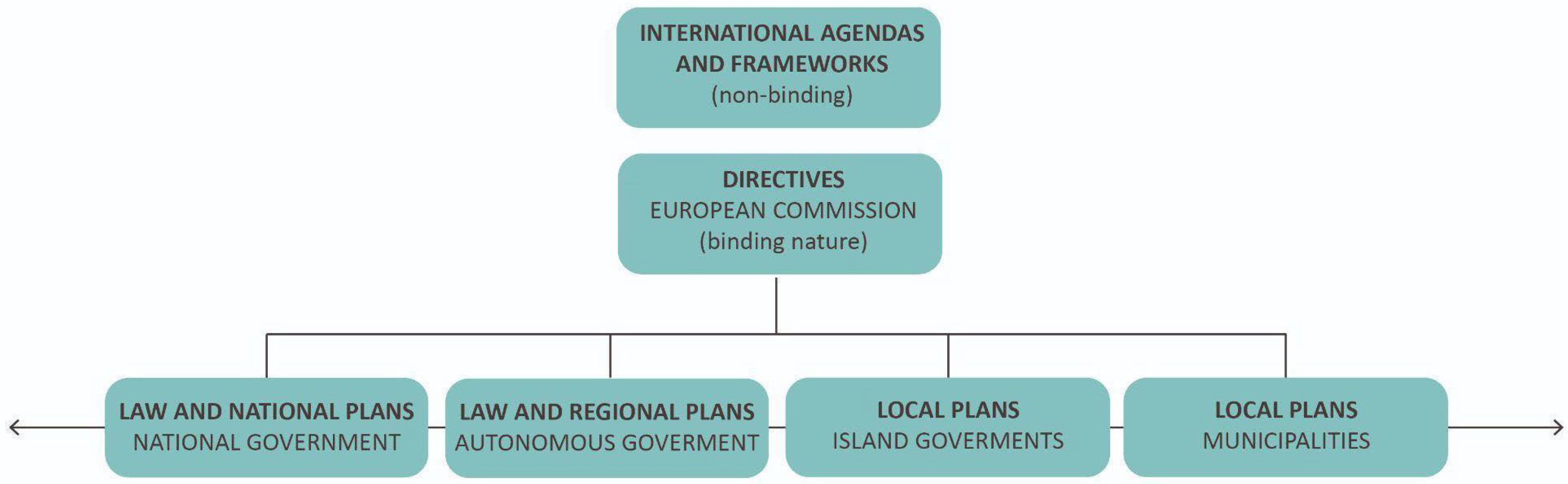
The outermost region status of the Canary Islands refers to their distance from mainland Spain and the rest of the European Union, encompassing not only geographical factors but also socio-economic aspects [61]. The OR status, combined with their vulnerability, exposure, and diverse hazards, requires policies adapted to the territorial, socio-economic, and cultural context. In 2022, the EU renewed its strategy for these territories, urging the promotion of research on climate change, strengthening regional cooperation, adapting Climate Social Fund plans to the ORs, and actively participating in the European climate adaptation mission [62]. DRR governance in the Autonomous Community of the Canary Islands is a multi-level, multi-actor system, integrating European, national, regional, island, and municipal policies (Figure 5).
The spatial scope of the Autonomous Community of the Canary Islands includes the archipelago, comprising the sea, the eight main islands, and the five islets, and it possesses its own legislative powers. Risk management is organized through a decentralized system, in which the Government of the Canary Islands develops planning and coordination at the regional level, while the island councils (Cabildos) and municipalities manage the drafting and implementation of plans, as well as emergency responses, in their respective territories. The functions of the Government include the approval of regulations, territorial and special plans and the creation of coordination bodies [64]. Coordination among administrations is carried out through the Canary Islands Civil Protection and Emergency Response Commission. Recently, the Government of the Canary Islands has established a Risk Analysis Unit within the Emergency and Security Coordination Center (CECOES) to support the evaluation and prevention work of the Directorate General of Emergencies.
The territorial organization of the Canary Islands and its particularity, the uniqueness of the insular phenomenon, has been recognized since 1978, establishing an administration for the islands composed of Cabildos or Councils. The organizational structure of the Cabildo Insular de Tenerife is divided into areas of competence, with the Presidency, Administration and Public Service; Territorial Planning and Historical Heritage Area; and the Natural Environment, Sustainability, Security and Emergencies Area being relevant to this study. Responsibilities for emergency management are assigned to the Natural Environment, Sustainability, Security, and Emergencies Area, which operates primarily through the Civil Protection Service. In addition, the sustainable development agenda and island-scale climate change adaptation planning were moved from the Office of the Presidency to be incorporated within this area.
The Candelaria City Council is organized into government areas that group political functions under the direction of the Municipal Management Office. The governing bodies consist of the Plenary, the Local Government Board, the Informative Commissions, and the Spokespersons Board. Additionally, the City Council has established five Community Forums to facilitate citizen participation. The council department responsible for risk management is the Department of Security, Emergencies, and Fleet Services. At the municipal level, the City Council Department of Urban and Environmental Planning and Management, Housing and Urban Agenda is also of interest for this study.

3.2. Management and Regulation

The results are presented below, organized according to the international and European framework, followed by the national context, and finally the local level, covering the three corresponding scales: regional, island, and municipal.

3.2.1. International Context

The year 2015 marked a turning point in the international context with the adoption of the Sendai Framework for Disaster Risk Reduction (March), the Addis Ababa Action Agenda of the Third International Conference on Financing for Development (July), the 2030 Agenda for Sustainable Development (September), the Paris Agreement—COP21 (December), and the preparatory process for the New Urban Agenda (HABITAT III). The approval of these frameworks and agendas in the same year is significant due to the interrelationships among the policies and agreements established. For example, improvements in DRR contribute to sustainable development, and the principles and criteria of sustainable development can help reduce exposure to natural hazards. All of these frameworks consider the interaction among hazards, include provisions aimed at reducing disaster risk and strengthening resilience, and emphasize the need for systemic and adaptive approaches. They explicitly advocate for spatial planning and governance that is integrated, multi-level, and risk-informed [65].
At the European Union level, the Preparedness Union Strategy (2025) was launched with the aim of supporting Member States in preventing threats and strengthening their response capacities. The Strategy comprises 30 key actions, together with an Action Plan designed to foster a culture of preparedness. The proposed actions cover a broad spectrum, ranging from the development of a comprehensive risk and threat assessment to the establishment of public–private cooperation frameworks [66]. The Strategy and the Action Plan focus primarily on emergency preparedness and advocate for an integrated all-risks approach. For its part, the European Climate Law legally enshrines the objective set out in the European Green Deal to make Europe’s economy and society climate-neutral by 2050. Additionally, as a core part of the European Green Deal, the link between climate change and disaster risk reduction is also crucial for the EU Adaptation Strategy, addressing the need to strengthen preparedness and incorporating specific preventive measures. Finally, under the Governance Regulation, Member States are required to develop integrated National Energy and Climate Plans and to provide updates on the advancement of their energy and climate policy implementation [67].

3.2.2. National Context

The 2030 Sustainable Development Strategy in Spain aims to implement the Sustainable Development Goals (SDGs) and the targets of the 2030 Agenda. The Strategy is based on the framework of the SDGs and their targets; however, it does not explicitly develop goals or priority actions related to SDG 11 or urban resilience. Among the identified strategic challenges, the Strategy highlights the need to address the climate and environmental emergency, and its targets include responding to the main risks posed by climate change. While issues related to DRR that are not associated with climate-related threats are not addressed in detail, DRR encompasses various aspects and sectors of development, linking them to the Strategy’s targets, enabling policies, and priority actions.
The National Climate Change Adaptation Plan 2021–2030 (PNACC) constitutes a key instrument for coordination and cross-cutting action to address the effects of climate change in Spain. Its development involved a broad collective process that resulted in nine interrelated specific objectives, reinforcing its coordinating role.
For its part, the Spanish Urban Agenda (AUE) establishes 10 strategic objectives along with specific objectives for each. Although “Strategic Objective 3: Prevent and reduce the impacts of climate change and improve resilience” could incorporate specific goals related to DRR, it focuses exclusively on the effects of climate change. Moreover, “Strategic Objective 1: Plan the territory and make rational use of land, conserve and protect it” is unlikely to address issues related to DRR unless they are explicitly included in its specific objectives and indicators. However, the national Land Law (2015) requires the development of risk mapping for land-use planning [68,69]. Finally, “Strategic Objective 10: Improve intervention instruments and governance” highlights the need for more flexible planning capable of transitioning toward more strategic frameworks; the role of governance as a process based on three pillars—transparency, collaboration, and participation; and the importance of collaboration and knowledge-transfer networks.
The development of strategies for DRR is not aimed solely at strengthening response plans to hazards but rather at improving society’s capacities to manage risk and potential disasters throughout the entire cycle (preparedness–prevention, response, and recovery) [70,71]. Currently, in Spain, there is no strategy defined in these terms, although the National Civil Protection Strategy, approved in 2024, can be noted. Its objectives and lines of action are aligned with the four strategic pillars established in the Horizonte 2035 Plan. It is important to highlight its reference to “risk enhancers,” such as climate change, inadequate land-use planning practices, globalization, and socioeconomic conditions.
Law 17/2015 establishes the development of a National Civil Protection System Strategy, which has not yet been approved and whose main objectives are to conduct a prospective analysis of risks and to align, integrate, and prioritize efforts in order to optimize the System’s resources. Its approval is scheduled for the period 2023–2026. In addition, one of the core pillars of the Horizon 2035 Plan is the adoption of regional and local strategies once the System Strategy has been approved. Emergency response planning in Spain is structured around the Basic Civil Protection Standard, together with civil protection plans, which include the General State Plan, Territorial Plans, Special Plans, and Self-Protection Plans.
Another document is the Effective Framework for Disaster Risk Management in Spain [72], which synthesizes the organizational framework for disaster risk management and climate change adaptation in Spain, complementing what is set out in the National Civil Protection Strategy and adding a set of general measures for prevention, preparedness and response, and post-emergency infrastructure rehabilitation.

3.2.3. Local Context: Documentary Corpus to Be Analyzed

A.
Regional Level: Canary Islands
With regard to strategic planning, the Canary Islands Sustainable Development Agenda (ACDS 2030) serves as a roadmap towards sustainability and resilience, aligned with the SDGs. Although SDG 11 aims to “make cities inclusive, safe, resilient, and sustainable,” significant information gaps and a lack of specific risk-related indicators for 2025 and 2030 persist. The 2024 report incorporates two indicators but notes that the diagnosis related to SDG 11 in the Canary Islands is still under development [73]. In this context, governance is structured through bodies such as the Canary Islands Sustainable Development Council, the Interinstitutional Operational Working Group for the ACDS 2030, the Innovation Centre for Sustainable Development, and the Multi-stakeholder Platform for the ACDS 2030.
Continuing with strategic planning, the Strategy for Demographic Challenge and Territorial Cohesion (ECan) integrates both territorial and insular perspectives, aiming to harmonize the relationship between population, territory, society, and economy. The Canary Islands Circular Economy Strategy (ECEC) seeks to drive the transition toward a more circular economic model, emphasizing environmental sustainability and competitiveness, while the Canary Islands Blue Economy Strategy (ECEA) aims to promote sustainable development of the maritime and coastal sector. Finally, the objective of the Canary Islands Smart Specialization Strategy (RIS3 Canarias) is to promote innovation and regional competitiveness by focusing on strategic areas with high growth potential, fostering research, technological development, and knowledge transfer. All of these strategies include a set of actions and measures to achieve their specific objectives, as well as dedicated governance structures.
For its part, Law 6/2022 of 27 December on climate change and energy transition in the Canary Islands promotes the mainstreaming of objectives across all sectoral policies, citizen participation, and institutional co-responsibility. It acts as a coordinating axis for climate action. In addition, it requires the adaptation of emergency and civil protection plans by incorporating the effects of climate change, extreme meteorological events, and the implementation of an early warning system for the islands and surrounding marine areas. This law is complemented by the Canary Islands Climate Action Strategy (ECAC 2040), which establishes regional guidelines, and by the still-developing Just Transition and Climate Justice Strategy (ECTJC 2040), focused on social adaptation. Furthermore, Law 6/2022 establishes a climate governance system that involves public administrations, citizens, and the private sector.
Likewise, the Guide to the Urban Agenda in the Canary Islands aims to facilitate the drafting of local action plans oriented towards the implementation of the Spanish Urban Agenda within the Canary Islands context. It is a methodological manual that introduces principles such as renaturation, decarbonisation, densification, and urban regeneration, under an approach based on participatory governance and continuous evaluation [74].
Territorial planning instruments constitute essential tools for reducing exposure and vulnerability and for preventing the generation of new risks through a prospective risk management approach [3,69,75]. In the Canary Islands, Law 14/2014 on Harmonisation and Simplification in matters of territorial protection and natural resources represents a key instrument for territorial and environmental planning in an archipelago in which approximately 40% of the land surface is protected due to its natural values. Similarly, Law 4/2017 of 13 July on Land Use and Protected Natural Areas of the Canary Islands regulates territorial planning and urban development across the archipelago, explicitly incorporating the obligation to address DRR and climate change impacts within land-use planning. At present, this law is undergoing a process of revision.
In the field of emergencies, Law 9/2007 on the Canary Islands System of Security and Emergencies strengthens prevention and response under principles of coordination and cooperation, defining competencies and promoting a prospective approach to risk management. It establishes the responsibilities of the regional government, the corresponding regional department, and the coordination and participation bodies. The law promotes prospective risk management, with an emphasis on training and participation by both operational services and the population. It focuses on mechanisms related to security, emergencies, and civil protection.
Emergency planning in the Canary Islands is structured through Territorial Plans, Special Plans, Specific Plans, and Self-Protection Plans. Territorial Plans address emergencies of a general nature, while Special and Specific Plans focus on particular risks that require tailored strategies. Self-Protection Plans, integrated into municipal emergency plans, enable activities or facilities with potential risk to have their own resources and protocols in place. The Territorial Civil Protection Plan of the Autonomous Community of the Canary Islands (PLATECA), in accordance with Law 2/1985 of 21 January on Civil Protection and the Basic Civil Protection Regulation (Royal Decree 407/1992), constitutes the central framework acting as the guiding plan for the overall regional civil protection system [76].
Table A3 in Appendix A presents the analysis of the current planning instruments examined. Fourteen instruments were analyzed at the regional level, of which six correspond to strategic planning and eight to emergency planning.
B.
Island Level: Tenerife
Regarding strategic planning, the Island Development Strategic Framework 2016–2025, promoted by the Cabildo Insular de Tenerife, represented a significant advance toward the implementation of an objective-oriented strategic model for the short, medium, and long term. This instrument allowed for the identification of priority actions across five axes. Axis 2: Social Action included among its programs the Sustainable Urban Development Strategies, while Axis 5: Sustainability and Environment incorporated the Tenerife Resilient Program. This Strategic Framework is integrated into the drafting of the Tenerife Sustainable Agenda 2030, which is currently under development alongside the Education for Sustainability Strategy. In addition, the completion of the Climate and Sustainable Energy Action Plan is also foreseen, which will be incorporated into the Island Climate Action Plan to be approved by the Cabildo in accordance with Law 6/2022.
The Island Land-Use Plan of Tenerife (PIOT) (B.O.C. No. 58, 21 March 2011) is presented as an attempt to integrate planning. At the time of its drafting, it was conceived as a document on natural resources, a territorial planning instrument, an urban development planning tool, and a framework for regulating tourism activities across the entire territory of Tenerife and its surrounding waters. Coinciding with the adaptation of the PIOT to the General Planning Guidelines and the Tourism Planning Guidelines in 2011, just over a year later, the Special Territorial Plan for Civil Protection Services (PTEOPRE) was approved, constituting a territorial planning instrument for the island, developed in accordance with the PIOT. This plan integrates the planning of civil protection facilities, risk analysis and zoning, and the development of a regulatory framework for urban and territorial planning that takes risk prevention into account.
Finally, emergency planning currently includes the Island Territorial Emergency Plan (PEIN), the Tenerife Island Volcanic Emergency Action Plan (PAIV), the Annual Plan for the Prevention, Monitoring, and Suppression of Forest Fires 2025 (INFOTEN), the Tenerife Flood Risk Management Plan (PGRI), and the Special Plan for Flood Defense in Tenerife (PDA). The latter, developed by the Tenerife Island Water Council (CIATF), incorporates among its flood preparedness measures the requirement that the Cabildo Insular de Tenerife develop an Island Action Plan for Flood Risk or a Specific Emergency Procedure for Floods, as established in Decree 115/2018 of 30 July.
Table A4 in Appendix A presents the analysis of the current planning instruments examined. Six instruments at the island level were analyzed, of which two correspond to territorial planning and four to emergency planning.
C.
Municipal Level: Candelaria
Candelaria has extensive annual and multiannual planning and programming, both sectoral and general. For the purposes of this study, the analysis focused on strategic planning, urban planning, and emergency planning. Regarding strategic planning, Candelaria has a long track record in the development of plans such as the Sustainable and Integrated Urban Development Strategies (2017–2022) and the Sustainable Urban Mobility Plan (2012). The Action Plan to implement the Spanish Urban Agenda, approved in 2022, constitutes the strategic intervention framework for the municipality and sets a precedent in the drafting of strategic documents for municipalities with populations between 20,000 and 50,000 inhabitants in the Canary Islands. The technical diagnosis is based on territorial data organized into five thematic blocks, proposing a series of thematic lines of action that are developed transversally, namely: renaturation, integrated water cycle, energy self-sufficiency, waste management, innovation, housing, and mobility [38].
The Climate and Sustainable Energy Action Plan (PACES) aims to reduce emissions in Candelaria by 40% and enhance the municipality’s resilience by addressing climate-related risks and vulnerabilities. Based on the diagnostic assessment, it proposes transversal and sectoral strategic lines focused on adaptation and mitigation processes within the competencies of the local administration.
In terms of urban planning, the Candelaria General Land-Use Plan (PGO) is an instrument aimed at promoting balanced and sustainable economic and social development [77]. At the time of its approval in 2006, the General Planning Guidelines already established the requirement to incorporate risk prevention into planning at all levels. However, the PTEOPRE had not yet been drafted (2012); therefore, only the structural provisions of the PIOT were applied.
Finally, there is the Candelaria Municipal Emergency Plan (PEMU), approved in 2010. This plan defines and organizes hierarchically and functionally the authorities and actors involved, coordinating resources, assessing risks, establishing preventive measures, and integrating actions with other plans and administrations to ensure its implementation and maintenance [78].
Table A5 in Appendix A synthesizes the analysis of the current planning instruments examined. Four instruments were analyzed at the municipal level: two strategic plans, one territorial planning instrument, and one emergency plan.

3.3. Results of the Risk Governance Analysis at Local Context

3.3.1. Regional Level: Canary Islands

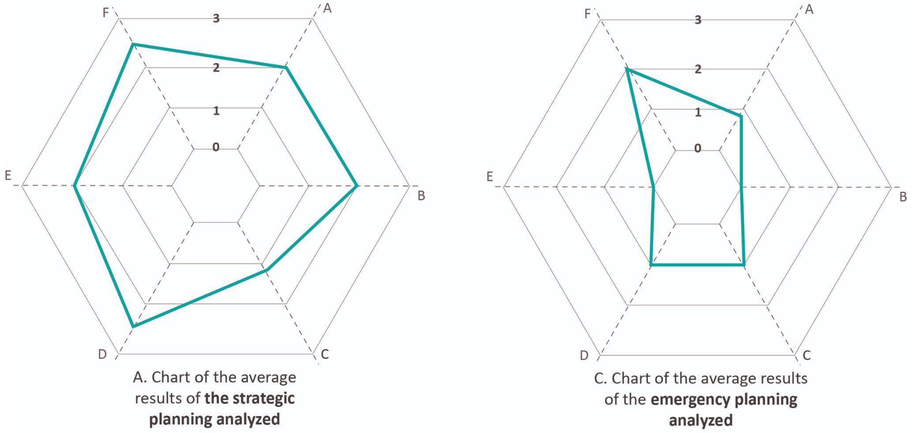
At the regional level, the Canary Islands have an institutional structure and policy instruments that could facilitate the integration of DRR and climate change. The regional government holds responsibilities for environmental protection, spatial planning, and disaster risk management. Table A3 in Appendix A presents the analysis conducted, grouping the instruments into two categories—strategic planning and emergency planning—as summarized in Figure 6. Unlike Table A2, Table A3 does not include the Planning Guidelines in the analysis, as they are not considered a planning instrument. In the field of strategic planning, the ACDS 2030 has represented a significant step forward by recognizing the interrelationship between development, sustainability, and risk. However, despite its comprehensive approach and the inclusion of targets related to resilience and risk management, the Agenda presents limitations in effectively addressing DRR. The dispersion of relevant provisions across different SDGs, targets, and sectoral objectives, in the absence of a binding framework, encourages selective interpretations. Moreover, the ACDS prioritizes development outcomes that are highly interrelated with DRR but does not sufficiently address the spatial and governance processes that contribute to the production of risk.
In turn, to address climate change and its associated hazards, the region does have the ECAC 2040 and its Action Plan at the regional level, which constitute a relevant starting point for collaborative planning, governance, and the implementation of sectoral measures [63]. As noted by González et al., one of the main challenges lies in integrating climate governance into interdisciplinary and sectoral legislation [63]. However, other non-climate-related hazards fall outside this framework. In this regard, there is no comprehensive DRR strategy at the regional scale that articulates the reduction of both climate and non-climate risks in a coherent manner, facilitating intersectoral and multilevel coordination. As at the national level, the Canary Islands lack a comprehensive DRR strategy that transversally articulates objectives, targets, and indicators [71], while greater progress and a coordinating role can be seen in climate change mitigation and adaptation, as does the ECAC and its Action Plan, derived from the Law 6/2022 of 27 December on Climate Change and Energy Transition of the Canary Islands.
In the analysis conducted, regarding strategic planning, it is worth highlighting the incorporation of climate change and other risks in both the ECan and the ECEA, not only in the context analysis but also in the strategies envisaged. Although they are neither part of the analysis matrix (Table A3) nor included in Figure 6, since they are not planning instruments, the Land Use and Protected Natural Areas Law of the Canary Islands incorporates risk and climate change adaptation into territorial planning. In this way, territorial and urban planning can be oriented toward DRR and the implementation of land-use regulations in vulnerable areas. For its part, the Guide to the Urban Agenda in the Canary Islands is mentioned as the framework document for the development of urban agendas in the Canary Islands and does not make reference to DRR.
Finally, within the scope of its competencies, civil protection planning does not establish coordination mechanisms with other key areas for DRR, nor does it explicitly address the effects of climate change—an aspect that is later incorporated in the Canary Islands Climate Change and Energy Transition Law. Likewise, it focuses on specific risks individually—such as floods, earthquakes, chemical hazards, the transport of dangerous goods, wildfires, and volcanic risks—leaving out, for example, geological hazards such as rockfalls (which are estimated to account for at least 89% of the mass movements observed in the archipelago) [79]. Furthermore, although the development of instruments aimed at addressing the impacts of climate change has involved the participation of various stakeholders, civil protection planning has not incorporated participatory processes. The plans establish an organizational and coordination structure, differentiating bodies according to the nature of the functions they perform—management, study and advisory, coordination, or direct intervention. However, coordination is not considered in the processes of drafting or implementing these plans. These issues reveal the persistence of significant gaps in risk governance across the entire risk management cycle—preparedness, response, and recovery.

3.3.2. Insular Level: Tenerife

The island of Tenerife does not yet have an approved sustainable development agenda or a strategy for adaptation and mitigation of the effects of climate change. However, both are currently under development, and progress is being made in education through initiatives such as the Island Environmental Education Action Plan and the Tenerife Environmental Participation and Volunteering Action Plan.
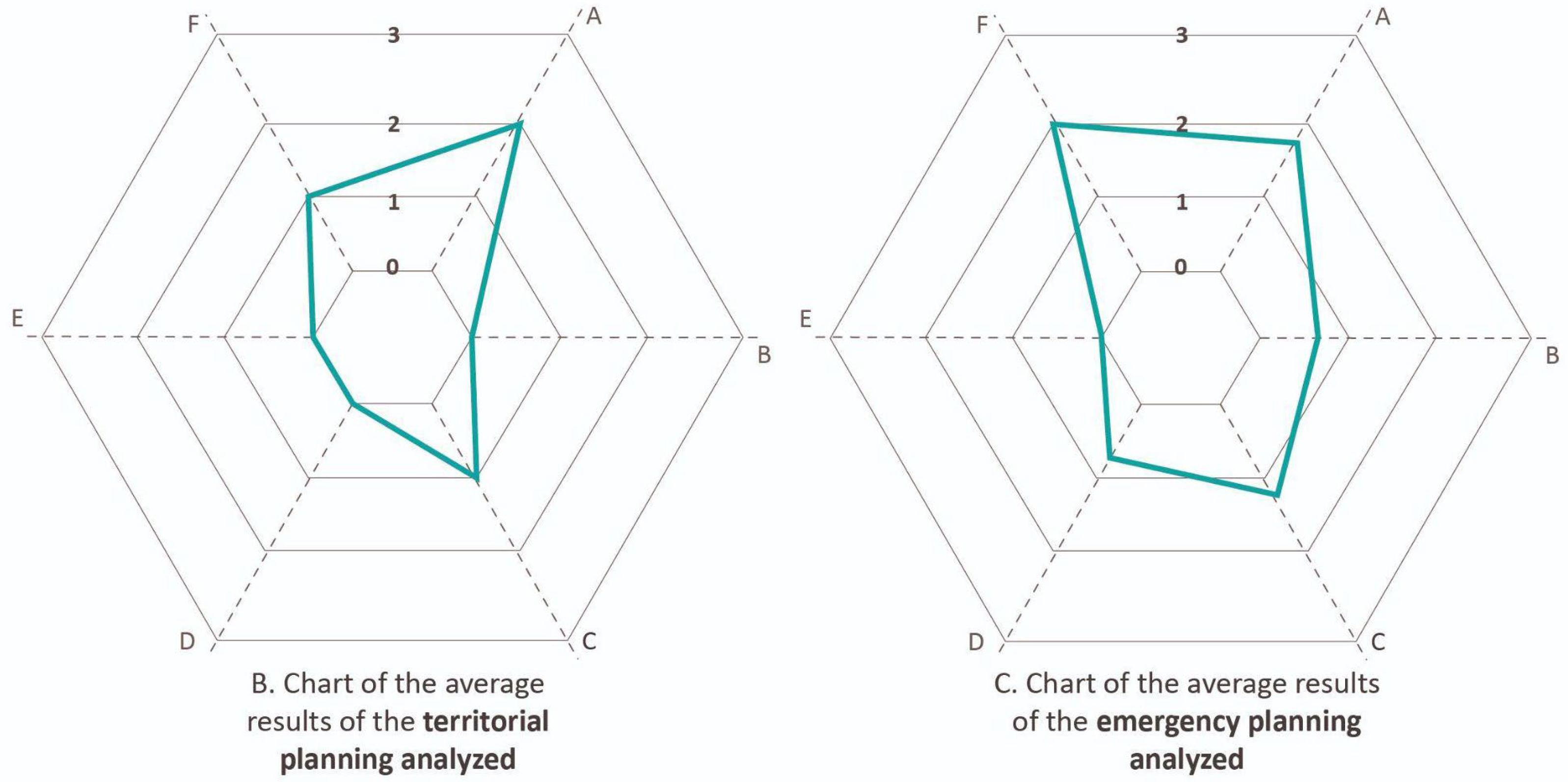
Table A4 in Appendix A presents the analysis conducted, grouping the instruments into two categories—(B) territorial planning and (C) emergency planning—as the aforementioned agendas have not been approved. Figure 7 summarizes the results of the analysis conducted at the island level. This analysis reveals the limited integration of DRR as well as climate change measures in the planning currently in place within the insular context. The lack of approval of strategic island-level planning does not facilitate the acceleration of this process. Regarding coordination, contributions to planning, implementation partnerships, and participation of both stakeholders and local and visiting populations continue to show significant gaps. Emergency planning has made progress in horizontal institutional coordination, yet public participation remains nonexistent.
In terms of implementation and monitoring, all plans include mechanisms that support their execution; however, the actual capacity to implement planned actions does not always materialize effectively, and the updating of plans is generally a slow and complex process. Tenerife is the only island with a PTEOPRE within its territorial planning framework. This plan, approved in 2012 using the methods and regulations in force at that time, represents a relevant precedent that requires updating in accordance with current legislation and the most recent available knowledge. In its normative document, the Territorial Plan addresses only volcanic risk, fire risk, and risks associated with slope dynamics, and most of its provisions are recommendations that lack binding authority. Furthermore, the risk assessment methodologies employed during its development differ in some cases from those currently applied in emergency planning on the islands.

3.3.3. Municipal Level: Candelaria

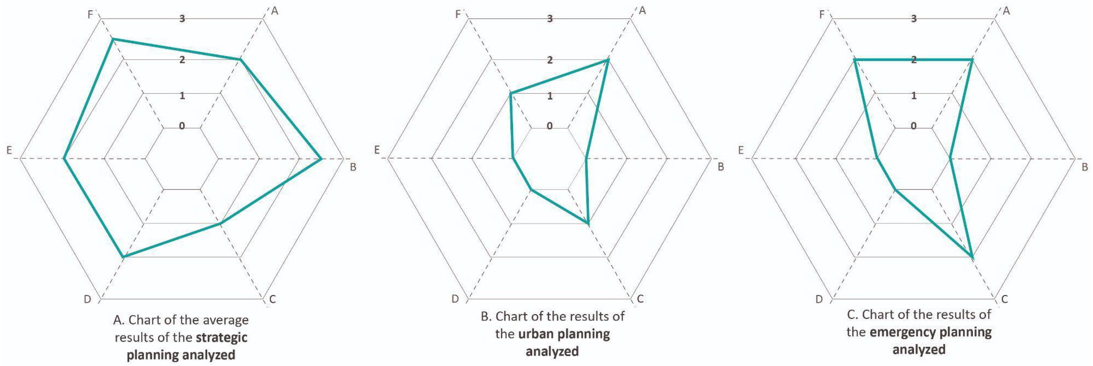
Figure 8 summarizes the results of the analysis conducted, detailed in Table A5 in the Appendix A, grouping the instruments into three categories: (A) strategic planning, (B) territorial planning, and (C) emergency planning. In the field of strategic planning, two instruments with strong integrative potential and a systemic perspective were analyzed: the Local Action Plan and the PACES. Although progress can be observed in the incorporation of climate change adaptation and mitigation measures, the same cannot be said for DRR. Nevertheless, advances can be identified in the incorporation of participatory processes in planning, particularly in comparison with urban planning and civil protection planning, areas in which participation remains virtually absent.
With regard to coordination, contributions, partnerships, knowledge, and participation, detailed territorial planning at the municipal level and emergency planning still present significant gaps. The updating of the PEMU, which is currently underway, and the need to revise the PGO, whose validity period is twenty years, represent important opportunities to incorporate a systemic perspective and to promote the participation of stakeholders.
In relation to the implementation and updating of plans, while the PACES establishes mechanisms for monitoring and updating, the Local Action Plan is limited to defining priorities and a timeline for each action, without including a specific mechanism for updating the plan, although it promotes a participation and updating system that does not exceed five years. Regarding territorial planning, the PGO also does not include updating mechanisms. It does not incorporate a specific risk analysis either, considering potential environmental impacts but not explicitly addressing the risks associated with natural, anthropogenic, or technological hazards, nor those linked to climate change.
Finally, the PEMU incorporates a risk catalog consistent with PLATECA, covering natural, anthropogenic, and technological risks. The main risks identified include intense rainfall, winds, coastal hazards, landslides, and seismic events, as well as extreme temperatures, forest fires, and chemical accidents. These risks, together with those identified in the PACES, directly affect territorial planning, urban development, and local socioeconomic development. However, they are not incorporated into the current planning framework.

4. Challenges and Opportunities

The Canary Islands have an advanced institutional structure and legal framework for emergency management, territorial planning, and addressing the impacts of climate change. However, the multiplicity of administrative levels, together with disciplinary fragmentation, does not facilitate the integration of cross-cutting policies. Establishing a robust risk governance system requires institutional collaboration at all levels, both vertically and horizontally [63]. Consistent with recent studies on the incorporation of DRR, institutional fragmentation, challenges in cross-sectoral collaboration, and outdated regulations are among the major obstacles to integrating DRR into planning [1,80]. Following the analysis categories defined in the matrix applied to the various instruments, the challenges and opportunities identified are detailed below.
Regarding the context analysis, overcoming fragmentation and sectoral silos remains one of the main challenges. Integrating a systemic perspective into administrative operations presents significant difficulties. Nonetheless, the high vulnerability, exposure, and diversity of hazards in the Canary Islands necessarily require a complex territorial perspective [4,6,18]. Similarly, decision-making in DRR and adaptation constitutes a complex process that requires the involvement of multiple sectors from the analysis phase and the co-creation of the diagnostic, an approach that is still observed to a limited extent, particularly in urban planning and civil protection planning [6]. Based on the analysis conducted, the civil protection sector faces the greatest difficulties in incorporating a systemic perspective into the designed planning structure and its areas of responsibility.
The results of the analysis show that the incorporation of DRR remains limited in instruments outside the civil protection domain, occupying a marginal role in plan formulation, despite the growing importance of integrated approaches [1] and the legal obligation for their inclusion (e.g., Law 4/2017). Since the approval of the Climate Change Law (2022), no measures have been incorporated into emergency planning or territorial planning. Although the incorporation of both climate and non-climate risks into regional-level strategic planning should be highlighted, the integration of non-climate risks diminishes at lower scales. Moreover, knowledge is not transferred either across levels or within the same institution; for example, non-climate change threats identified in the PEMU of Candelaria do not appear in other municipal instruments. One of the main conflicts lies in the temporal asymmetry among different planning instruments, as well as between territorial and urban planning and the urgent need to make decisions regarding DRR and adaptation. Neither the PIOT nor the PTEOPRE align with recent regional strategies, such as the ECAC approved in 2023, and neither general urban planning nor civil protection plans have been able to integrate existing legal obligations. These limitations highlight structural weaknesses in risk governance and adaptive governance [1,63]. The effectiveness of DRR and adaptation in insular contexts depends on articulating local and sectoral regulations across multiple scales and implementing governance mechanisms that ensure their compliance [63].
Based on lessons learned from past disasters, numerous studies have proposed guidelines and planning frameworks aimed at strengthening the integration of DRR [81,82]. A recent example in the Canary Islands is the ongoing process to amend the Island Land-Use Plan of La Palma to integrate risk considerations and green infrastructure following the Tajogaite eruption (2021) [83]. Likewise, the need to incorporate anticipatory mechanisms for post-disaster phases within the fields of law, land-use planning, and urban development has been highlighted [84]. In this context, the implementation of Tenerife’s PAIV was also promoted following the conclusion of the La Palma eruption [85], along with the initial steps toward drafting a volcanic risk reduction strategy for the Canary Islands [86]. This period also saw the publication of studies highlighting the need to adopt a multi-hazard perspective in order to design multi-risk management programs in volcanic island contexts [87], as well as research demonstrating the predictive capacity of probabilistic simulation models to support decision-making during volcanic eruptions [88]. Similarly, the recurring need for a flood emergency plan in Tenerife has been identified, as well as the importance of translating scientific knowledge into territorial planning at the municipal scale [89]. The implementation of nature-based solutions has gained particular relevance in an insular context, where increased tourism and demographic growth have been identified as factors driving the expansion of urban areas without adequate consideration of risks [90], neither with respect to wildfires [91] nor in terms of multi-hazard and multi-vulnerability approaches in decision-making [40].
Among the identified opportunities, the existence of an administrative structure and a legal framework stands out, enabling progress toward the integration of DRR and risk-based planning [92]. Likewise, the development of projects and initiatives that foster networking and knowledge transfer [80,93,94] reinforces the importance of incorporating the perspectives of diverse stakeholders and advancing the translation of scientific knowledge into public policy and practice [5]. Initial progress is also observed in the implementation of the Urban Agenda in Tenerife, exemplified by the Candelaria Action Plan, which constitutes a relevant precedent. Although this instrument does not integrate DRR, it includes actions that, when aligned with risk knowledge, could contribute to risk reduction. Furthermore, the ongoing update of the PEMU and the necessary revision of the PGO represent key opportunities to incorporate DRR and climate change adaptation. In this regard, the stages of review, risk assessment, and analysis, together with implementation and monitoring, are identified as particularly suitable moments to facilitate alignment between territorial planning and disaster risk management, as highlighted in several studies on operationalizing such integration [69,95].
In relation to the category of coordination, contributions, and partnerships, although planning increasingly incorporates multilevel coordination mechanisms and structures, these processes lack clear collaboration agreements and partnerships among the groups, services, and entities involved at different levels. Moreover, the practical effectiveness of existing coordination mechanisms remains weak, promoting a fragmented execution of responsibilities. Vertical collaboration between island councils and municipalities is generally limited, while horizontal links across different areas are predominantly determined by individual or departmental capacity and political will [63], where informality predominates [93]. Coordination deficiencies among actors also hinder the effective sharing and use of data. Civil protection and territorial planning operate separately (Section 3.2), impeding interaction between management dynamics and collaborative governance [96], and maintaining a significant gap between policies such as strategic planning, land-use planning, and disaster management. This situation is frequently constrained by conflicts of interest, ambiguities in responsibilities, and tensions regarding which regulations should prevail [63,97]. In this context, coordination is identified as one of the main challenges in risk governance.
Among the lessons learned from wildfire management strategies and the emergency triggered by the Tajogaite volcano in La Palma in 2021, it becomes evident that effective risk governance requires the integration of environmental, territorial, and social policies [91]. Intersectoral alliances and coordinated links between institutions at different scales are essential. In this context, digital tools emerge as key facilitators of coordination [1,98,99]. The need and relevance of these digital tools is consistently evidenced in the focus groups conducted within the framework of projects such as MYRIAD-EU and in the implementation of the PAIV of Tenerife [100]. Alongside strategic planning, efforts are being made to facilitate institutional data through web-based viewers and platforms. Efforts to advance the regional viewer in terms of data, cartography, and plan digitization are also highlighted. At the municipal level, Candelaria has included among its actions, within the framework of the Action Plan, the creation of a municipal Geographic Information Systems (GIS) platform, a Data Observatory, and a Municipal Corporate Platform to store and share information, thereby promoting collaborative work between administrative and political personnel [101]. Access to these advancements was available for a limited period. However, the main challenge lies in ensuring the continuity of these initiatives, which are often constrained by administrative procedures and lack of maintenance.
In the category related to processes for fostering shared knowledge and participation, the results reveal the absence of participatory processes for DRR. Despite the participatory nature of emergency preparedness, the involvement of the local community remains largely limited to outreach, awareness, and occasional consultation through interviews, which have yet to be incorporated into planning. In current planning, both DRR and the analyzed territorial planning continue to lack meaningful inclusion and effective participatory mechanisms with communities. Key challenges include variability in the perceived need to involve the population across disciplines and institutions, community distrust in the processes, weak feedback mechanisms, ensuring diversity among participants, and transforming potential conflicts into consensus. Despite these limitations, recent experiences highlight the value and relevance of participation in improving risk governance on the island, as well as adaptation and preparedness strategies [93,102,103].
Research and practice have advanced the understanding of stakeholders as active actors who enrich the knowledge available for planning and management, contributing to more effective decision-making and improved problem-solving [104]. Several authors highlight the need to move beyond one-way communication models and advance toward participatory frameworks in which the population contributes to all phases of disaster risk governance [1,103]. The literature on participatory DRR emphasizes benefits such as increased effectiveness, efficiency, and sustainability of interventions, as well as a more equitable distribution of risks [7]. At the local level, especially at the municipal scale, community-based planning supports more adaptive approaches [91], and the continuous participation of stakeholders is essential to tailor outcomes to local needs [93]. In this context, Candelaria has structures that can facilitate these processes, such as Community Boards—spaces for meetings, dialogue, and collaboration—and Sectoral Boards—bodies for information sharing, discussion, and consultation. Emphasizing the local context and participatory approaches helps avoid standardized policies that could create new vulnerabilities [1].
Regarding the implementation, monitoring, evaluation, and updating system, although both emergency planning and strategic planning include sections dedicated to these aspects, the actual operational capacity to implement, execute, evaluate, and update plans is limited. In the analyzed context, some studies point to a lack of technical capacity and resources at the municipal level [63], while others, in the field of territorial and urban planning, highlight difficulties in updating plans due to the occurrence of various factors such as procedural, technical, and temporal complexity, economic costs, and political priorities [91].
Institutional learning, understood as social learning that leads to changes in formalized or organized practices, can be observed at different levels of governance through learning loops (Section 1.2). Reactive or single-loop learning predominates, which is reflected, for example, in improvements to early warning systems and the provision of technological enhancements within institutions [105]. Double-loop learning, which involves reviewing and adjusting existing planning approaches, is less frequent due to prolonged periods without plan updates. Currently, the organizational and operational structure of Civil Protection is undergoing transformation with the creation of the Canary Islands Emergency Agency [105]. Finally, triple-loop learning, which transforms the system to strengthen DRR, is the most complex. Examples of this type of learning include modifying territorial and urban planning to address the underlying causes of risk and integrating a systemic perspective into risk governance.
In summary, the analysis of challenges and opportunities in risk governance highlights the complexity and multi-scalar nature of the system under study, while also pointing to potential avenues for improvement. The absence of a systemic vision and a multi-hazard, multi-risk approach in current regulations hinders their incorporation into existing planning, despite growing international attention to systemic risk and multi-hazard events [19,21,106,107]. Moreover, although regulations and frameworks exist that promote risk-informed planning, these have not been sufficient to integrate such approaches into key instruments for the territorial development of the island and the municipality. The lack of a comprehensive DRR strategy underscores the reliance on the willingness and capacity of drafting teams, services, and sectors to develop coordinated strategies across areas, entities, and levels of government, beyond emergency management and civil protection. This situation is particularly critical in light of the 2023 Sendai Framework Midterm Review (MTR), which emphasizes the urgency of adopting integrated approaches that address risks at their source [108].

5. Conclusions

Analyses of risk governance allow for the identification of institutional structures, implementation patterns, and barriers that limit the integration and advancement of disaster risk reduction (DRR) and climate change adaptation, providing key insights for improving policies and processes [1]. This research aimed to analyze risk governance, with an emphasis on disaster risks, at the local level across three scales: regional, island, and municipal. It is the first study to address this governance framework for DRR, based on a review of specialized literature and a qualitative and comparative analysis of thirty-nine regulatory and strategic instruments, seeking to identify areas of opportunity, propose reflections, and outline potential future research directions.
During the course of the study, it was observed that research aimed at adopting a systemic approach to risk governance is continuously evolving. Likewise, the understanding, assessment, and management of multi-hazards and multi-risks are gaining increasing relevance in research, policy, and practice. In the case study, the results highlight a broad yet still fragmented institutional structure, in which risk management continues to be concentrated in the response phase and within the scope of civil protection. The effective integration of risk into strategic and territorial planning remains uneven, limiting the transition toward systemic and multi-hazard risk governance. In this regard, the most recent international frameworks emphasize the need to promote structural transformations that address the underlying drivers of vulnerability and exposure. This study shows that planning has primarily progressed by focusing on external hazards, while the structural conditions shaping exposure and vulnerability—such as land-use planning and the prevailing development model—have received comparatively less attention. As a result, a predominantly reactive form of risk governance persists, closely associated with civil protection and lacking a comprehensive DRR strategy grounded in a systemic perspective, thereby perpetuating existing vulnerabilities and contributing to the generation of new risks.
Furthermore, progress in improving risk governance is constrained by difficulties in achieving effective coordination, as well as by the limited consolidation of participatory processes. This is compounded by the limited implementation of existing instruments and the reduced capacity of current planning frameworks to respond to evolving risks, incorporate changes, and adapt to dynamic contexts.
Among the identified opportunities, the existence of an advanced institutional and legal framework stands out, providing a favorable basis for advancing the integration of DRR and climate change adaptation into planning. Lessons learned from recent disasters also represent an important opportunity, as they contribute to strengthening risk perception and highlight the need to enhance preparedness and review existing planning instruments. The development of projects and initiatives that promote knowledge networks and cooperation also offers opportunities, facilitating information exchange and knowledge transfer among institutional, scientific, and sectoral actors, such as the MYRIAD-EU project or the BlueGreen Governance Project. Additionally, initial progress in integrating the urban agenda at the municipal scale, together with ongoing processes to review and update planning instruments, constitute strategic opportunities to incorporate DRR and climate change adaptation. Further opportunities include the emerging development of participatory approaches in strategic planning, as well as the existence of community governance structures—such as the Community and Sectoral Boards of Candelaria—and the formal recognition of governance structures within recently approved strategic planning. Taken together, these contributions outline pathways for the transition toward systemic risk governance.
This study presents some limitations that should be considered when interpreting its findings. First, the analysis is confined to a single municipality, which limits its generalizability. In this regard, future research should expand the scope of analysis to other municipalities and islands in order to enable comparative assessments and strengthen external validity, taking advantage of the transferability of the methodological framework employed. Second, the analysis of risk governance is restricted to the specific objectives defined in the methodology, the corresponding analytical categories proposed, and a selected set of planning instruments. Consequently, other potentially relevant analytical categories and planning domains—such as sectoral planning—were not considered, although they could offer additional insights. Moreover, the analytical tool used does not allow for the assessment of the quality or relevance of risk reduction and adaptation-related provisions within the instruments analyzed. In addition, the study focuses on institutional structures and formal governance frameworks, which limits its ability to capture other forms of interaction among actors, as well as the informal dynamics that also influence DRR. Furthermore, given the temporal nature of planning processes, medium- and long-term monitoring is required to draw more robust conclusions regarding the effectiveness of integrating DRR and climate change adaptation. In this context, it is important to note that the findings are not static and may evolve in response to future updates, revisions, or the approval of new planning instruments or regulatory frameworks. Finally, future research could incorporate the perspectives of different stakeholders involved in planning—including policymakers, technical staff, and social actors—as well as further explore learning loops. Each of the analytical dimensions of risk governance proposed here opens up potential avenues for future research, and the analytical tool itself could be expanded to include additional dimensions. Likewise, in light of the findings, it would be pertinent to examine in greater detail aspects such as the processes of plan implementation across different scales, as well as the creation and functioning of coordination bodies established to monitor the various plans, and to further explore learning loops.
In conclusion, this study highlights that advancing toward truly integrated risk governance in insular contexts requires overcoming institutional fragmentation and promoting a systemic, participatory, and anticipatory vision. The experience analyzed in Candelaria and Tenerife demonstrates how strategic planning, the integration of urban agendas, lessons learned from recent disasters, and participatory approaches constitute key opportunities to strengthen DRR and climate change adaptation. These findings underscore the need to combine scientific knowledge, institutional innovation, and social participation to consolidate more resilient insular territories that are better prepared to face multiple risks.

Author Contributions

Conceptualization, T.F.A., J.D.-P. and P.D.A.; methodology, T.F.A., J.D.-P. and P.D.A.; formal analysis, T.F.A., J.D.-P. and L.M.Q.; investigation T.F.A., J.D.-P., P.D.A., L.M.Q. and A.L.-D.; resources, A.L.-D.; Writing—Original draft preparation, T.F.A. and J.D.-P.; Writing—Review and editing, T.F.A., P.D.A., L.M.Q. and A.L.-D.; visualization T.F.A.; supervision T.F.A.; project administration A.L.-D.; funding acquisition A.L.-D. All authors have read and agreed to the published version of the manuscript.

Funding

This research is funded by the Canary Agency for Research, Innovation and Information Society (ACIISI) of the Ministry of Universities, Science, Innovation and Culture, and the Canary Islands 2021–2027 Integrated Operational Program of the European Social Fund Plus (ESF+), Priority Axis 3, Thematic Priority 74 (85%), as the first author is part of a researcher training program. This work has been financed through the Planclimac 2 project, Development and Monitoring of Coordinated Actions in the Macaronesia Region on Climate Change Risks and Threats (1/MAC/2/2.4/0006). The project is co-financed by the European Union through the Interreg VI-D MAC (Madeira-Azores-Canary Islands) Cooperation Program 2021–2027.

Data Availability Statement

No data was used for the research described in the article.

Acknowledgments

This research is part of the MYRIAD-EU project: Multi-hazard and Systemic Framework for Enhancing Risk-Informed Management and Decision-Making in the EU. In addition, it has been developed within the framework of a collaboration agreement between the Environmental and Territorial Planning and Management Company S.A. (GESPLAN) and the Chair of Disaster Risk Reduction and Resilient Cities at the University of La Laguna. Finally, we thank the anonymous reviewers for their comments that improved the manuscript.

Conflicts of Interest

The authors declare no conflicts of interest.

Appendix A

Table A1. Regulation instruments in the Canary Islands.
CategoriesRegulation
TerritoryLaw 19/2003 of April 14, approving the General Planning Guidelines and the Tourism Planning Guidelines of the Canary Islands
Law 14/2014 on Harmonisation and Simplification in matters of territorial protection and natural resources
Law 4/2017 of 13 July on Land Use and Protected Natural Areas of the Canary Islands
Decree 181/2018 of December 26, approving the Canary Islands Land-Use Planning Regulation
RisksLaw 9/2007 on the Canary Islands System of Security and Emergencies
Law 43/2003 of 21 November on Forests, as amended by Law 21/2015 of 20 July
Law 6/2022 of 27 December on climate change and energy transition in the Canary Islands
Royal Decree 524/2023 of 20 June, approving the Basic Civil Protection Standard
Table A2. Planning instruments in the Canary Islands.
CategoriesPlanning Instruments
Strategic planningCanary Islands Sustainable Development Agenda (ACDS 2030)
Guide to the Urban Agenda in the Canary Islands
Canary Islands Climate Action Strategy (ECAC 2040)
Canary Strategy for Demographic Challenge and Territorial Cohesion (ECan)
Canary Islands Circular Economy Strategy (ECEC 2030)
Canary Islands Blue Economy Strategy (ECEA 2030)
Canary Islands Smart Specialization Strategy (RIS3)
Territorial planningThe Planning Guidelines constitute the strategic territorial planning instrument of the Government of the Canary Islands, serving as a reference framework for the other planning instruments
Emergency planningTERRITORIAL PLANS
Territorial Civil Protection Plan of the Autonomous Community of the Canary Islands (PLATECA)
Special Territorial Plan for Risk Prevention (PTE-1)
SPECIAL PLANS
Special Civil Protection and Emergency Response Plan for Seismic Risk in the Autonomous Community of the Canary Islands (PESICAN)
Special Civil Protection and Emergency Response Plan for Volcanic Risk in the Autonomous Community of the Canary Islands (PEVOLCA)
Special Civil Protection and Emergency Response Plan for Forest Fires in the Autonomous Community of the Canary Islands (INFOCA)
Special Civil Protection and Emergency Response Plan for Radiological Risk in the Autonomous Community of the Canary Islands (RADICAN)
Special External Emergency Plan for Chemical Risk in the Canary Islands (RISQCAN)
Special Civil Protection and Emergency Response Plan for Flood Risk in the Autonomous Community of the Canary Islands (PEINCA)
Specific Civil Protection and Emergency Response Plan of the Autonomous Community of the Canary Islands for Adverse Meteorological Events (PEFMA)
Table A3. Analysis of planning instruments in the Canary Islands.
Analyzed Current Planning FrameworkContext AnalysisIntegration of Climate Change Mitigation and AdaptationIntegration of Other RisksCoordination, Contributions, and PartnershipsKnowledge and ParticipationImplementation, Monitoring, Evaluation, and Updating System
ACDS 2030221123
ECAC 2040230222
ECan222322
ECEC 2030221322
ECEA 2030222323
RIS3211323
PLATECA102002
PESICAN101002
PEVOLCA101002
INFOCA101002
RADICAN101002
RISQCAN001002
PEINCA101002
PEFMA101002
Table A4. Analysis of planning instruments at the island level.
Analyzed Current Planning FrameworkContext AnalysisIntegration of Climate Change Mitigation and AdaptationIntegration of Other RisksCoordination, Contributions, and PartnershipsKnowledge and ParticipationImplementation, Monitoring, Evaluation, and Updating System
Island Land-U (PIOT)200001
Special Territorial Plan for Civil Protection Services (PTEOPRE)202001
Island Territorial Emergency Plan (PEIN)202002
Tenerife Island Volcanic Emergency Action Plan (PAIV)201002
Annual Plan for the Prevention, Monitoring, and Suppression of Forest Fires 2025 (INFOTEN)111001
Tenerife Flood Risk Management Plan (PGRI)221303
Table A5. Analysis of instruments at the municipal level.
Analyzed Current Planning FrameworkContext AnalysisIntegration of Climate Change Mitigation and AdaptationIntegration of Other RisksCoordination, Contributions, and PartnershipsKnowledge and ParticipationImplementation, Monitoring, Evaluation, and Updating System
Action Plan to implement the Spanish Urban Agenda (2022)221222
Climate and Sustainable Energy Action Plan (2022)231223
Candelaria General Land-Use Plan (PGO)201001
Candelaria Municipal Emergency Plan (PEMU)202002

References

  1. Zhang, S.; Wang, Q.; Ma, R.; Furuya, K. Integrating disaster risk reduction with planning and design across scales: A review of research trends, challenges, and solutions. Prog. Disaster Sci. 2026, 29, 100531. [Google Scholar] [CrossRef]
  2. United Nations. International Decade for Natural Disaster Reduction: Report of the Secretary-General; United Nations: New York, NY, USA, 1999. [Google Scholar]
  3. United Nations Office for Disaster Risk Reduction. Sendai Framework for Disaster Risk Reduction 2015–2030; United Nations: New York, NY, USA, 2015; Available online: https://www.undrr.org/publication/sendai-framework-disaster-risk-reduction-2015-2030 (accessed on 15 March 2026).
  4. Mitra, A.; Shaw, R. Systemic risk from a disaster management perspective: A review of current research. Environ. Sci. Policy 2023, 140, 122–133. [Google Scholar] [CrossRef]
  5. van Maanen, N.; de Ruiter, M.; Jäger, W.; Casartelli, V.; Ciurean, R.; Padron, N.; Daloz, A.S.; Geurts, D.; Gottardo, S.; Hochrainer-Stigler, S.; et al. Bridging science and practice on multi-hazard risk drivers: Stakeholder insights from five pilot studies in Europe. Earth Syst. Dynam. 2025, 16, 2295–2311. [Google Scholar] [CrossRef]
  6. Hochrainer-Stigler, S.; Šakić Trogrlić, R.; Reiter, K.; Ward, P.J.; de Ruiter, M.C.; Duncan, M.J.; Torresan, S.; Ciurean, R.; Mysiak, J.; Stuparu, D.; et al. Toward a framework for systemic multi-hazard and multi-risk assessment and management. iScience 2023, 26, 106736. [Google Scholar] [CrossRef]
  7. Wilkinson, E. Disaster Risk Governance in Volcanic Areas: A Concept Note for Work Package 4 of the Strengthening Resilience in Volcanic Areas (STREVA) Programme; Overseas Development Institute: London, UK, 2013. [Google Scholar]
  8. Nemakonde, L.D.; Van Niekerk, D. A normative model for integrating organisations for disaster risk reduction and climate change adaptation within SADC member states. Disaster Prev. Manag. Int. J. 2017, 26, 361–376. [Google Scholar] [CrossRef]
  9. Stoker, G. Governance as theory: Five propositions. Int. Soc. Sci. J. 1998, 50, 17–28. [Google Scholar] [CrossRef]
  10. Pelling, M.; Wisner, B. Disaster Risk Reduction: Cases from Urban Africa; Earthscan: London, UK, 2009. [Google Scholar]
  11. Ahrens, J.; Rudolph, P.M. The importance of governance in risk reduction and disaster management. J. Conting. Crisis Manag. 2006, 14, 207–220. [Google Scholar] [CrossRef]
  12. Nuñez, M.A.; Ocampo-Salazar, C. Dimensiones de la gobernanza del riesgo de desastres: Una revisión sistemática. Rev. Estud. Latinoam. Sobre Reducción Riesgo Desastr. REDER 2025, 9, 51–66. [Google Scholar] [CrossRef]
  13. Fuentealba, R.; Verrest, H. Disrupting risk governance? A post-disaster politics of inclusion in the urban margins. Urban Plan. 2020, 5, 274–287. [Google Scholar] [CrossRef]
  14. Biermann, F. Earth system governance as a crosscutting theme of global change research. Glob. Environ. Chang. 2007, 17, 326–337. [Google Scholar] [CrossRef]
  15. Renn, O.; Klinke, A.; van Asselt, M. Coping with complexity, uncertainty and ambiguity in risk governance: A synthesis. AMBIO 2011, 40, 231–246. [Google Scholar] [CrossRef]
  16. Pahl-Wostl, C. A conceptual framework for analysing adaptive capacity and multi-level learning processes in resource governance regimes. Glob. Environ. Chang. 2009, 19, 354–365. [Google Scholar] [CrossRef]
  17. Renn, O.; Laubichler, M.; Lucas, K.; Kröger, W.; Schanze, J.; Scholz, R.W.; Schweizer, P.-J. Systemic risks from different perspectives. Risk Anal. 2020, 42, 1902–1920. [Google Scholar] [CrossRef]
  18. Sillmann, J.; Christensen, I.; Hochrainer-Stigler, S.; Huang-Lachmann, J.-T.; Juhola, S.; Kornhuber, K.; Mahecha, M.D.; Mechler, R.; Reichstein, M.; Ruane, A.C.; et al. Briefing Note: Systemic Risk—Review and Opportunities for Research, Policy and Practice from the Perspective of Climate, Environmental and Disaster Risk Science and Management; International Science Council: Paris, France; United Nations Office for Disaster Risk Reduction: Geneva, Switzerland, 2022; Available online: https://www.undrr.org/media/78607/download (accessed on 10 March 2026).
  19. Linkov, I.; Trump, B.D. Resilience and governance. In The Science and Practice of Resilience: Risk, Systems and Decisions; Linkov, I., Trump, B.D., Eds.; Springer: Cham, Switzerland, 2019; pp. 67–88. [Google Scholar] [CrossRef]
  20. Pescaroli, G.; Guida, K.; Reynolds, J.; Pulwarty, R.S.; Linkov, I.; Alexander, D.E. Managing systemic risk in emergency management, organizational resilience and climate change adaptation. Disaster Prev. Manag. Int. J. 2023, 32, 234–251. [Google Scholar] [CrossRef]
  21. Maskrey, A.; Jain, G.; Lavell, A. The social construction of systemic risk: Towards an actionable framework for risk governance. Disaster Prev. Manag. Int. J. 2023, 32, 4–26. [Google Scholar] [CrossRef]
  22. International Risk Governance Center (IRGC). Guidelines for the Governance of Systemic Risks; IRGC: Lausanne, Switzerland, 2018. [Google Scholar] [CrossRef]
  23. Geels, F.W. Socio-Technical Transitions to Sustainability. In Oxford Research Encyclopedia of Environmental Science; Hank, S., Ed.; Oxford University Press: New York, NY, USA, 2018. [Google Scholar] [CrossRef]
  24. Intergovernmental Panel on Climate Change (IPCC). Annex I: Glossary. In Global Warming of 1.5 °C: An IPCC Special Report on the Impacts of Global Warming of 1.5 °C Above Pre-Industrial Levels and Related Global Greenhouse Gas Emission Pathways, in the Context of Strengthening the Global Response to the Threat of Climate Change, Sustainable Development, and Efforts to Eradicate Poverty; Masson-Delmotte, V., Zhai, P., Pörtner, H.-O., Roberts, D., Skea, J., Shukla, P.R., Pirani, A., Moufouma-Okia, W., Péan, C., Pidcock, R., et al., Eds.; IPCC: Geneva, Switzerland, 2018. [Google Scholar]
  25. Brooks, N.; Adger, W.N.; Kelly, P.M. The determinants of vulnerability and adaptive capacity at the national level and the implications for adaptation. Glob. Environ. Chang. 2005, 15, 151–163. [Google Scholar] [CrossRef]
  26. Morgan, M.G.; Dowlatabadi, H.; Henrion, M.; Keith, D.; Lempert, R.J.; McBride, S.; Small, M.; Wilbanks, T. Best Practice Approaches for Characterizing, Communicating, and Incorporating Scientific Uncertainty in Decision Making: Synthesis and Assessment Product 5.2 of the U.S. Climate Change Science Program; National Oceanic and Atmospheric Administration: Washington, DC, USA, 2009.
  27. National Research Council (NRC). Informing Decisions in a Changing Climate: Panel on Strategies and Methods for Climate-Related Decision Support; Committee on the Human Dimensions of Global Change, Division of Behavioral and Social Sciences and Education: Washington, DC, USA; The National Academies Press: Washington, DC, USA, 2009.
  28. BS 6500:2014; Guidance on Organisational Resilience. BSI: London, UK, 2014.
  29. Field, C.B.; Barros, V.; Stocker, T.F.; Qin, D.; Dokken, D.J.; Ebi, K.L.; Mastrandrea, M.D.; Mach, K.J.; Plattner, G.K.; Allen, S.K.; et al. (Eds.) Managing the Risks of Extreme Events and Disasters to Advance Climate Change Adaptation: A Special Report of Working Groups I and II of the Intergovernmental Panel on Climate Change (IPCC); Cambridge University Press: Cambridge, UK, 2012. [Google Scholar]
  30. Baird, A.; O’Keefe, P.; Westgate, K.; Wisner, B. Towards an Explanation and Reduction of Disaster Proneness; University of Bradford Disaster Research Unit: Bradford, UK, 1975; Volume 11. [Google Scholar]
  31. Carracedo Gómez, J.C.; Tilling, R.I. Geología y Volcanología de Islas Volcánicas Oceánicas (Canarias-Hawaii): Apuntes Para Unas Lecciones de Volcanología; Servicio de Publicaciones de la Caja General de Ahorros de Canarias: Santa Cruz de Tenerife, Spain, 2003. [Google Scholar]
  32. United Nations Office for Disaster Risk Reduction (UNDRR). Making Development Sustainable: The Future of Disaster Risk Management. Global Assessment Report on Disaster Risk Reduction; United Nations Office for Disaster Risk Reduction: Geneva, Switzerland, 2015. [Google Scholar]
  33. Dorta Antequera, P. Catálogo de riesgos climáticos en Canarias: Amenazas y vulnerabilidad. Geographicalia 2007, 51, 133–160. [Google Scholar] [CrossRef]
  34. Correa, J.; Dorta, P. Assessment of large forest fires in the Canary Islands and their relationship with subsidence, thermal inversion, and atmospheric conditions. Geographies 2025, 5, 37. [Google Scholar] [CrossRef]
  35. Pescador Monagas, F.; Mirallave Izquierdo, V.; Taira Alonso, J.J. ISLAB. Islas Como Laboratorios del Antropoceno: La Adaptación Urbana al Cambio Climático en Contextos Insulares: Canarias y Cabo Verd; Grupo de Investigación Reconocido (GIR) URBSCAPES: Valladolid, Spain, 2021. [Google Scholar]
  36. Mederos Santana, D. Some Elements of the Tourist Offer in Non-Tourist Areas. The Case of Güímar and Candelaria; Trabajo Fin de Grado; Universidad de La Laguna, Facultad de Economía, Empresa y Turismo: San Cristóbal de La Laguna, Spain, 2021. [Google Scholar]
  37. Instituto Nacional de Estadística (INE). Población por Provincias y Sexo. INE, 2025. Available online: https://www.ine.es (accessed on 10 December 2025).
  38. Ayuntamiento de Candelaria. Plan de Acción Local de Implementación de la Agenda Urbana Española en Candelaria; Ayuntamiento de Candelaria: Santa Cruz de Tenerife, Spain, 2022. [Google Scholar]
  39. Martín Raya, N. Modelos Geográficos Aplicados a la Reducción del Riesgo de Desastres en Espacios Insulares. Ph.D. Thesis, Universidad de La Laguna, San Cristóbal de La Laguna, Spain, 2025. [Google Scholar]
  40. Martín-Raya, N.; Díaz-Pacheco, J.S.; López-Díez, A. Multi-hazard risk assessment analysis in La Palma: An approach for risk mitigation. Geoenviron. Disasters 2024, 11, 33. [Google Scholar] [CrossRef]
  41. Gobierno de Canarias. Plan de Actuación Insular Frente al Riesgo Volcánico de Tenerife (PAIV). Boletín Oficial de la Provincia de Santa Cruz de Tenerife (BOP No. 113). Available online: https://www.bopsantacruzdetenerife.es/bopsc2/index.php (accessed on 10 December 2025).
  42. Ritchie, H. Natural Disasters; OurWorldInData: Oxford, UK, 2022; Available online: https://ourworldindata.org/natural-disasters (accessed on 5 December 2025).
  43. Carracedo, J.C.; García-Rodríguez, M.; Ortega-Guerrero, B.; Guillou, H. Temporal and spatial evolution of the 2021 eruption in the Tajogaite volcano (Cumbre Vieja rift zone, La Palma, Canary Islands) from geophysical and geodetic parameter analyses. Nat. Hazards Earth Syst. Sci. 2023, 118, 2245–2284. [Google Scholar] [CrossRef]
  44. Rossi, M.; Sarro, R.; Reichenbach, P.; Mateos, R.M. Probabilistic identification of rockfall source areas at regional scale in El Hierro (Canary Islands, Spain). Geomorphology 2021, 381, 107661. [Google Scholar] [CrossRef]
  45. López-Díez, A. Cambio Climático y Fenómenos Meteorológicos Extremos en la Macaronesia: Evaluación, Adaptación y Resiliencia. Ph.D. Thesis, Universidad de La Laguna, San Cristóbal de La Laguna, Spain, 2020. [Google Scholar]
  46. Espino, E.P.C.; Calvento, L.H.; Luque, A.Y. Transformaciones humanas y sus consecuencias sobre los litorales de las Islas Canarias. In Les Littoraux Volcaniques: Une Approche Environnementale; Paris, R., Ed.; Presses Universitaires Blaise-Pascal: Clermont-Ferrand, France, 2007; pp. 173–191. [Google Scholar]
  47. Yanes, A.; Marzol, M.V.; Romero, C. Characterization of sea storms along the coast of Tenerife, the Canary Islands. J. Coast. Res. 2006, 48, 124–128. [Google Scholar]
  48. Yanes-Luque, A. Desastres naturales en Canarias: La costa como espacio de riesgo en Tenerife. Semata Cienc. Sociais Humanidades 2017, 29, 4150. [Google Scholar] [CrossRef][Green Version]
  49. López-Díez, A.; Dorta, P.; Díaz-Pacheco, J.; Carballo Acosta, O. Consecuencias de los Eventos Meteorológicos de Rango Extraordinario en Canarias: Temporales de Viento, Inundaciones y Fenómenos Costeros (1996–2016); Universidad de La Laguna: San Cristóbal de La Laguna, Spain, 2018; Available online: https://repositorio.aemet.es/handle/20.500.11765/9953 (accessed on 1 May 2025).
  50. Dorta, P.; Domínguez, A.; Díaz-Pacheco, J.; López-Díez, A.; Martín-Raya, N. Tropical disturbances in the southeastern North Atlantic: State of the art and future prospects. Investig. Geográficas 2023, 79, 33. [Google Scholar] [CrossRef]
  51. Amador González, A.; Marzol Jaén, M.V. La frecuencia e intensidad de las sequías en las vertientes meridionales de las Islas Canarias (1970–2018). Investig. Geográficas 2021, 61, 78–86. [Google Scholar] [CrossRef]
  52. Agencia Estatal de Meteorología (AEMET). Avance Climatológico de Canarias: Octubre 2023. 2023. Available online: https://www.aemet.es/es/serviciosclimaticos/vigilancia_clima/resumenes?w=1&k=coo (accessed on 22 November 2025).
  53. Martín-Raya, N.; López-Díez, A.; Lillo Ezquerra, Á. Characterisation and Analysis of Large Forest Fires (LFFs) in the Canary Islands, 2012–2024. Fire 2026, 9, 7. [Google Scholar] [CrossRef]
  54. Murillo, P. La Calima, el Viento y el Fuego Cierran el Espacio Aéreo y Marítimo en Canarias. EL PAÍS. 23 February 2020. Available online: https://elpais.com/politica/2020/02/23/actualidad/1582449863_096738.html (accessed on 4 December 2025).
  55. Ayuntamiento de Candelaria. Incidencias Candelaria: Alerta por Vientos. 14 March 2022. Available online: https://www.candelaria.es/incidencias-candelaria-alerta-por-vientos-14-marzo-2022/ (accessed on 23 February 2026).
  56. Ayuntamiento de Candelaria. Actualización Recomendaciones e Incidencias Alertas Máximas. Available online: https://www.candelaria.es/actualizacion-recomendaciones-e-incidencias-alertas-maximas-25-septiembre/ (accessed on 23 February 2026).
  57. Ayuntamiento de Candelaria. Información: Incendio Forestal Candelaria. 16 August 2023. Available online: https://www.candelaria.es/informacion-incendio-forestal-candelaria/ (accessed on 23 February 2026).
  58. Ayuntamiento de Candelaria. Incidencias y Medidas: Situación de Alerta por Riesgo de Inundaciones Costeras en Candelaria. Available online: https://www.candelaria.es/incidencias-y-medidas-situacion-de-alerta-por-riesgo-de-inundaciones-costeras-en-candelaria/ (accessed on 23 February 2026).
  59. Page, M.J.; McKenzie, J.E.; Bossuyt, P.M.; Boutron, I.; Hoffmann, T.C.; Mulrow, C.D.; Shamseer, L.; Tetzlaff, J.M.; Akl, E.A.; Brennan, S.E.; et al. The PRISMA 2020 statement: An updated guideline for reporting systematic reviews. BMJ 2021, 372, n71. [Google Scholar] [CrossRef]
  60. United Nations Office for Disaster Risk Reduction (UNDRR). Disaster Resilience Scorecard for Cities; UNDRR: Geneva, Switzerland, 2017; Available online: https://mcr2030.undrr.org/disaster-resilience-scorecard-cities (accessed on 15 November 2025).
  61. Domínguez Vila, A.; Rodríguez-Drincourt Álvarez, J.R. Comentarios a la Ley Orgánica 1/2018, de 5 de Noviembre, de Reforma del Estatuto de Autonomía de Canarias, 1st ed.; Iglesias Machado, S., Expósito Suárez, I., Coord, Eds.; Marcial Pons: Madrid, Spain, 2020; Available online: https://isbnsearch.org/isbn/9788434026582 (accessed on 16 October 2025).
  62. Comisión Europea. Dar Prioridad a las Personas, Asegurar el Crecimiento Sostenible e Inclusivo y Liberar el Potencial de las Regiones Ultraperiféricas de la UE (COM(2022) 198 Final); Comisión Europea: Brussels, Belgium, 2022; Available online: https://eur-lex.europa.eu/legal-content/ES/TXT/?uri=COM:2022:198:FIN (accessed on 16 October 2025).
  63. González, A.G.; Peña-Alonso, C.; González-Dávila, M.; Santana-Casiano, J.M.; González-Santana, D.; Ferraro, G.; Naranjo-Almeida, L.; García-Romero, L. Governance challenges for the adaptation to sea-level rise in the Canary Islands: A multilevel approach. Ocean Soc. 2025, 2, 165–189. [Google Scholar] [CrossRef]
  64. Asamblea Legislativa de Canarias. Ley 9/2007, de 13 de Abril, del Sistema Canario de Seguridad y Emergencias y de Modificación de la Ley 6/1997, de 4 de Julio, de Coordinación de las Policías Locales de Canarias. Boletín Oficial de Canarias. 13 April 2007. Available online: https://www.boe.es (accessed on 16 October 2025).
  65. United Nations. New Urban Agenda. 2017. Available online: https://www.un.org/en/events/citiesday/assets/pdf/the-new-urban-agenda.pdf (accessed on 12 November 2025).
  66. European Commission. Preparedness; European Commission: Brussels, Belgium, 2025; Available online: https://commission.europa.eu/topics/preparedness_es?prefLang=es (accessed on 15 February 2026).
  67. European Commission. Governance of the Energy Union and Climate Action; European Commission: Brussels, Belgium, 2024; Available online: https://climate.ec.europa.eu/eu-action/climate-strategies-targets/governance-energy-union-and-climate-action_en?prefLang=es (accessed on 15 February 2026).
  68. Vargas, J.; Olcina, J.; Paneque, P. Cartografía de riesgo de inundación en la planificación territorial para la gestión del riesgo de desastre: Escalas de trabajo y estudios de casos en España. Rev. EURE—Rev. Estud. Urbano Reg. 2022, 48, 1–25. [Google Scholar] [CrossRef]
  69. Olcina-Cantos, J.; Díez-Herrero, A. Inundaciones en España: El papel de la planificación territorial. Ciudad Territ. Estud. Territ. 2025, 57, 7–46. [Google Scholar] [CrossRef]
  70. Díaz Pacheco, J.; López Díez, A.; Dorta Antequera, P. Desarrollo de una estrategia canaria para la reducción del riesgo de desastres. In La Palma: Una isla de Oportunidades: Repensando el Futuro a Partir de la Crisis Volcánica; García Rodríguez, F.J., Fernández Hernández, C., Eds.; Fundación Fyde CajaCanarias: Santa Cruz de Tenerife, Spain, 2023; pp. 351–358. [Google Scholar] [CrossRef]
  71. Díaz Pacheco, J.; López Díez, A.; Dorta Antequera, P.J. De la emergencia a la resiliencia: Estrategia de Reducción del Riesgo de Desastres. Ambient. Rev. Minist. Medio Ambiente 2025, 144, 80–89. [Google Scholar]
  72. Ministerio para la Transición Ecológica y el Reto Demográfico. Marco Eficaz de Gestión del Riesgo de Catástrofes en España. Madrid, Spain, 2021. Available online: https://www.miteco.gob.es/content/dam/miteco/es/cambio-climatico/temas/impactos-vulnerabilidad-y-adaptacion/marcoeficazriesgosespana_tcm30-524627.pdf (accessed on 1 May 2026).
  73. Consejo Canario de Desarrollo Sostenible. Informe de Progreso y Dinamización de la Agenda Canaria 2030, 2024 ed.; Consejo Canario de Desarrollo Sostenible: Santa Cruz de Tenerife, Spain, 2024; Available online: https://www.gobiernodecanarias.org/agendacanaria2030/documentos/ (accessed on 1 May 2026).
  74. Consejería de Transición Ecológica, Lucha contra el Cambio Climático y Planificación Territorial del Gobierno de Canarias. Guía Metodológica de la Agenda Urbana en Canarias: Metodología para la Redacción de un Plan de Acción Local de Implementación de la Agenda Urbana Española en el Contexto del Archipiélago Canario; Gobierno de Canarias: Santa Cruz de Tenerife, Spain, 2023. Available online: https://www.gobiernodecanarias.org/planificacionterritorial/materias/agenda-urbana/agenda-urbana-canaria/gmt-guia-metodologica-version-digital/ (accessed on 1 May 2026).
  75. Olcina Cantos, J. El tratamiento de los riesgos naturales en la planificación territorial de escala regional. Papeles Geogr. 2010, 51–52, 223–234. [Google Scholar]
  76. Gobierno de Canarias. Plan Territorial de Emergencias de Protección Civil de la Comunidad Autónoma de Canarias (PLATECA); Gobierno de Canarias: Santa Cruz de Tenerife, Spain, 2015.
  77. Ayuntamiento de Candelaria. Plan General de Ordenación de Candelaria (PGO); Ayuntamiento de Candelaria: Candelaria, Spain, 2006. [Google Scholar]
  78. Ayuntamiento de Candelaria. Plan de Emergencias Municipal de Candelaria 2010; Ayuntamiento de Candelaria: Candelaria, Spain, 2010. [Google Scholar]
  79. Montoya-Montes, I.; Galindo, I.; Sánchez, N.; García López-Davalillo, J.C.; García, I.; Cruz Pérez, N.; Ortega, A.; Santamarta, J.C.; Rodríguez Alcántara, J.S.; Hernández Ruiz, M.; et al. Citizens’ observatory on rockfalls in the Canary Islands, Spain. In Citizens’ Observatories on Geohazards, Geoenvironmental Disaster Reduction; Gomes, R.C., Correia, V., Bodó, B., Eds.; Springer: Cham, Switzerland, 2025; pp. 155–169. [Google Scholar] [CrossRef]
  80. Šakić Trogrlić, R.; Reiter, K.; Ciurean, R.L.; Gottardo, S.; Torresan, S.; Daloz, A.S.; Ma, L.; Padrón Fumero, N.; Tatman, S.; Hochrainer-Stigler, S.; et al. Challenges in assessing and managing multi-hazard risks: A European stakeholders perspective. Environ. Sci. Policy 2024, 157, 103774. [Google Scholar] [CrossRef]
  81. Kilvington, M.; Saunders, W. Gaining public input on natural hazard risk and land-use planning. Disaster Prev. Manag. Int. J. 2019, 28, 228–244. [Google Scholar] [CrossRef]
  82. Tag-Eldeen, Z.N. Bridging urban planning knowledge into post-disaster response: Early recovery road map within the international humanitarian cluster system. Int. J. Disaster Risk Reduct. 2017, 24, 399–410. [Google Scholar] [CrossRef]
  83. Cabildo de La Palma. La Palma Incorporará la Prevención de Riesgos y las Infraestructuras Verdes a su Planeamiento Insular. 18 March 2025. Available online: https://www.cabildodelapalma.es/es/la-palma-incorporara-la-prevencion-de-riesgos-y-las-infraestructuras-verdes-su-planeamiento-insular (accessed on 11 February 2026).
  84. Viña Guerra, J.E. Riesgos y desastres naturales: Tratamiento legal urgente de los efectos territoriales y urbanísticos de una catástrofe. Rev. Derecho Urbanístico Medio Ambiente 2023, 57, 121–185. [Google Scholar]
  85. Diario de Tenerife. (2021, Julio 2). El Cabildo Comienza la Implantación del Plan de Actuación Frente al Riesgo Volcánico. Available online: https://www.diariodetenerife.info/el-cabildo-comienza-la-implantacion-del-plan-de-actuacion-frente-al-riesgo-volcanico/ (accessed on 17 October 2025).
  86. Pérez, N.M. Estrategia canaria para la reducción del riesgo volcánico: Una necesidad. In Tajogaite. Enseñanzas de una Erupción Volcánica (La Palma, Otoño 2021): Actas de la XVIII Semana Científica Telesforo Bravo; Afonso Carrillo, J.M., Ed.; Instituto de Estudios Hispánicos de Canarias: Santa Cruz de Tenerife, Spain, 2023; pp. 191–229. [Google Scholar]
  87. López-Saavedra, M.; Martí, J. Multi-hazard risk assessment at the Canary Islands. In Advances in Natural Hazards and Volcanic Risks: Shaping a Sustainable Future. NATHAZ 2022; Malheiro, A., Fernandes, F., Chaminé, H.I., Eds.; Advances in Science, Technology & Innovation; Springer: Cham, Switzerland, 2023. [Google Scholar] [CrossRef]
  88. Martín-Raya, N.; Díaz-Pacheco, J.; López-Díez, A.; Antequera, P.D.; Cabrera, A. A lava flow simulation experience oriented to disaster risk reduction, early warning systems and response during the 2021 volcanic eruption in Cumbre Vieja, La Palma. Nat. Hazards 2023, 117, 3331–3351. [Google Scholar] [CrossRef]
  89. Martín-Raya, N.; Díaz-Pacheco, J.; Dorta Antequera, P.; López-Díez, A. Identifying urban prone areas to flash floods: The case of Santa Cruz de Tenerife. Prog. Disaster Sci. 2024, 24, 100372. [Google Scholar] [CrossRef]
  90. López-Saavedra, M.; Martí, J.; Planagumà, L. How Effective Risk Assessment and Management Is the Key to Turning Volcanic Islands into a Source of Nature-Based Solutions. Land 2023, 12, 686. [Google Scholar] [CrossRef]
  91. Medina Morales, F.; Máyer Suárez, P.; Álvarez, F.T.; Quesada Ruiz, L. Wildfire Dynamics and Risk in the Wildland–Urban Interface in Gran Canaria (Spain): Influence of Climate Change, Land Management, and Civil Protection Policies. Geographies 2026, 6, 9. [Google Scholar] [CrossRef]
  92. Galasso, C.; McCloskey, J.; Pelling, M.; Hope, M.; Bean, C.J.; Cremen, G.; Guragain, R.; Hancilar, U.; Menoscal, J.; Mwang’a, K.; et al. Editorial: Risk-based, pro-poor urban design and planning for tomorrow’s cities. Int. J. Disaster Risk Reduct. 2021, 58, 102158. [Google Scholar] [CrossRef]
  93. Ward, P.J.; Buijs, S.L.; Ciurean, R.; Claassen, J.N.; Daniell, J.; De Polt, K.; Duncan, M.; Gottardo, S.; Hochrainer-Stigler, S.; Šakić Trogrlić, R.; et al. Reducing risk together: Moving towards a more holistic approach to multi-hazard and multi-risk assessment and management. Nat. Hazards Earth Syst. Sci. 2026, 26, 1325–1345. [Google Scholar] [CrossRef]
  94. European Commission. BlueGreen Governance (Grant Agreement No. 101086091). Horizon Europe Research and Innovation Actions. CORDIS—EU Research Results. (2024–2027). Available online: https://cordis.europa.eu/project/id/101086091 (accessed on 14 February 2026).
  95. Wang, J.-J. Integrated model combined land-use planning and disaster management: The structure, context and contents. Disaster Prev. Manag. Int. J. 2012, 21, 110–123. [Google Scholar] [CrossRef]
  96. Ruane, S.; Swapan, M.S.H.; Babb, C. Disaster risk reduction in bushfire prone areas: Challenges for an integrated land use planning policy regime. Sustainability 2020, 12, 10496. [Google Scholar] [CrossRef]
  97. Pinardo-Barco, S.; Sanromualdo-Collado, A.; García-Romero, L. Can the long-term effects of beach cleaning heavy duty machinery on aeolian sedimentary dynamics be detected by monitoring of vehicle tracks? An applied and methodological approach. J. Environ. Manag. 2023, 325, 116645. [Google Scholar] [CrossRef]
  98. Galderisi, A.; Guida, G.; Limongi, G. Emergency and spatial planning towards cooperative approaches: Challenges and opportunities in the multi-risk area of Campi Flegrei. TeMA-J. Land Use Mobil. Environ. 2021, 73–92. [Google Scholar] [CrossRef]
  99. Prenger-Berninghoff, K.; Cortes, V.J.; Sprague, T.; Aye, Z.C.; Greiving, S.; Głowacki, W.; Sterlacchini, S. The connection between long-term and short-term risk management strategies for flood and landslide hazards: Examples from land-use planning and emergency management in four European case studies. Nat. Hazards Earth Syst. Sci. 2014, 14, 3261–3278. [Google Scholar] [CrossRef]
  100. Febles Arévalo, T.L.; Díaz Pacheco, J.; Dorta Antequera, P.; López-Díez, A. Participatory methodology for risk management planning: A strategy for the implementation of the Tenerife Island Volcanic Emergency Action Plan. Int. J. Disaster Risk Reduct. 2025, 120, 105356. [Google Scholar] [CrossRef]
  101. Vargas González, R. Agenda Urbana de Candelaria. Plan de Acción Local de implementación de la Agenda Urbana Española en el T.M. de Candelaria (Canarias). Planur-E Territ. Urban. Paisaje Sostenibilidad Diseño Urbano 2023, 38. Available online: https://www.planur-e.es/index.php (accessed on 17 October 2025).
  102. Hernandez, Y.; Barbosa, P.; Corral, S.; Rivas, S. An institutional analysis to address climate change adaptation in Tenerife (Canary Islands). Environ. Sci. Policy 2018, 89, 184–191. [Google Scholar] [CrossRef]
  103. Pearce, L. Disaster management and community planning, and public participation: How to achieve sustainable hazard mitigation. Nat. Hazards 2003, 28, 211–228. [Google Scholar] [CrossRef]
  104. Abderhalden, J.M.; Scolobig, A.; Stoffel, M.; Huang Lachmann, J.-T.; Calvello, M. Barriers and enablers to stakeholder engagement in the co-creation of disaster risk reduction solutions. Int. J. Disaster Risk Reduct. 2025, 120, 105381. [Google Scholar] [CrossRef]
  105. Gobierno de Canarias. Canarias Unifica y Moderniza su Sistema de Protección Civil Para Mejorar la Respuesta Ante las Emergencias. 2025. Available online: https://www3.gobiernodecanarias.org/noticias/canarias-unifica-y-moderniza-su-sistema-de-proteccion-civil-para-mejorar-la-respuesta-ante-las-emergencias/ (accessed on 1 May 2026).
  106. Dijkman, M. A Framework for Assessing Systemic Risk; World Bank Policy Research Working Paper No. 5282; World Bank: Washington, DC, USA, 2010; Available online: https://documents.worldbank.org/curated/en (accessed on 13 December 2025).
  107. United Nations Development Programme (UNDP). Social Construction of Systemic Risk: Towards an Actionable Framework for Risk Governance; UNDP: New York, NY, USA, 2021. [Google Scholar]
  108. UNDRR. The Report of the Midterm Review of the Implementation of the Sendai Framework for Disaster Risk Reduction 2015–2030. 2023. Available online: https://sendaiframework-mtr.undrr.org/publication/report-midterm-review-implementation-sendai-framework-disaster-risk-reduction-2015-2030 (accessed on 5 February 2026).
Figure 1. Geographic context. Adapted from the MYRIAD-EU project.
Geographies 06 00047 g001
Figure 2. Location of the island of Tenerife and the municipality of Candelaria highlighted in orange.
Geographies 06 00047 g002
Figure 3. Risk governance analysis matrix.
Geographies 06 00047 g003
Figure 4. Analytical diagram.
Geographies 06 00047 g004
Figure 5. Schematic institutional structure. Adapted from González et al. [63].
Geographies 06 00047 g005
Figure 6. Risk governance analysis at the regional level: (A) strategic planning and (C) emergency planning. Each axis is described in Figure 4. Diagram B is missing, as no spatial planning has been analyzed.
Geographies 06 00047 g006
Figure 7. Risk governance analysis at the island level: (B) territorial planning and (C) emergency planning. Each axis is described in Figure 4. Diagram A is missing, as no strategic planning has been analyzed.
Geographies 06 00047 g007
Figure 8. Analysis of risk governance at the municipal level. Each axis is described in Figure 4.
Geographies 06 00047 g008
Disclaimer/Publisher’s Note: The statements, opinions and data contained in all publications are solely those of the individual author(s) and contributor(s) and not of MDPI and/or the editor(s). MDPI and/or the editor(s) disclaim responsibility for any injury to people or property resulting from any ideas, methods, instructions or products referred to in the content.