Review

Geomorphological Mapping Global Trends and Applications

by
Adolfo Quesada-Román
* and
Manuel Peralta-Reyes
Physical Geography Laboratory, School of Geography, Universidad de Costa Rica, San José 2060, Costa Rica
*
Author to whom correspondence should be addressed.
Geographies 2023, 3(3), 610-621; https://doi.org/10.3390/geographies3030032
Submission received: 8 August 2023 / Revised: 11 September 2023 / Accepted: 14 September 2023 / Published: 17 September 2023
(This article belongs to the Special Issue Mapping of People and Places for Statistics)

Abstract

:
This study conducts a bibliometric analysis of 735 research papers on geomorphological mapping published in English between 2000 and 2021 using the Web of Science database. The analysis focuses on key metrics such as annual publication rates, journal distribution, common keywords, and frequently cited papers. The results demonstrate sustained investment in geomorphological mapping research over the past two decades, driven by advancements in data analysis, GIS technologies, and cross-institutional and cross-country collaboration. While European universities and research centers lead the field, researchers from Latin America and Asia are also making noteworthy contributions. However, research concentration remains largely in Europe, particularly at low altitudes. The study highlights the vital importance of investment in geomorphological mapping research and the benefits of collaboration to advance understanding and knowledge production. It also emphasizes the need for greater geographic and cultural diversity among researchers to ensure a more comprehensive and inclusive approach to research in this field.

1. Introduction

Geomorphological mapping is a fundamental component of Earth Science that has gained increasing importance in recent years [1,2]. Geomorphology is the scientific study of landforms and the processes that shape them, including erosion, weathering, and tectonic activity [3,4]. The process of geomorphological mapping involves the identification, classification, and description of processes and landforms using a combination of field observations, remote sensing data, and topographic maps [5,6].
Geomorphological mapping is essential for understanding the Earth’s surface and the processes that shape it [7,8]. It provides valuable information for a range of scientific disciplines, including geology, geography, hydrology, ecology, and archaeology [9,10]. Geomorphological maps can be used to identify potential natural hazards, such as landslides, volcanic eruptions, and floods, and to create strategies for management and mitigation of their associated risks [11,12,13,14,15]. Moreover, geomorphological mapping is crucial for the exploration and management of natural resources. It provides valuable information on the distribution, composition, and structure of geological formations, including mineral deposits, oil and gas reservoirs, and groundwater aquifers [16,17,18]. This information is essential for making informed decisions about natural resources extraction, conservation, and management [19,20,21].
In recent years, advances in remote sensing technology and digital mapping techniques have revolutionized the field of geomorphological mapping, enabling scientists to generate highly detailed and accurate maps of the Earth’s surface [22,23,24,25]. These advances have opened new opportunities for interdisciplinary research and collaboration, as well as for the development of innovative solutions to global challenges such as climate change and environmental degradation [26,27,28]. Given the importance of geomorphological mapping in Earth Science, it is essential that we continue to invest in this field, supporting research, education, and technological development [29,30,31]. By doing so, we can deepen our understanding of the Earth’s surface, its processes, and its resources, and develop sustainable strategies for managing and conserving our planet [32,33,34].
Geomorphological mapping research has shown significant growth in the past two decades, with advances in data analysis, GIS technologies, and global collaboration contributing to increased knowledge production. However, research concentration remains largely in Europe, and there is a need for greater geographic and cultural diversity among researchers to ensure a more comprehensive and inclusive approach to research in this field [35,36,37,38]. The study aim is to perform a bibliometric analysis of geomorphological mapping studies published in English between 2000 and 2021 to classify its key trends and applications. Specifically, the study aims to assess annual publication rates, journal distribution, common keywords, frequently cited papers, and geographic and cultural diversity among researchers.
The study’s findings may have significant implications for the future of geomorphological mapping research. The sustained growth of research in this field demonstrates the importance of continued investment and collaboration to advance understanding and knowledge production. However, the concentration of research in Europe highlights the need for greater geographic and cultural diversity among researchers to ensure a more comprehensive and inclusive approach to research. This study may help to inform future research strategies and funding priorities to promote more equitable and collaborative research in geomorphological mapping.

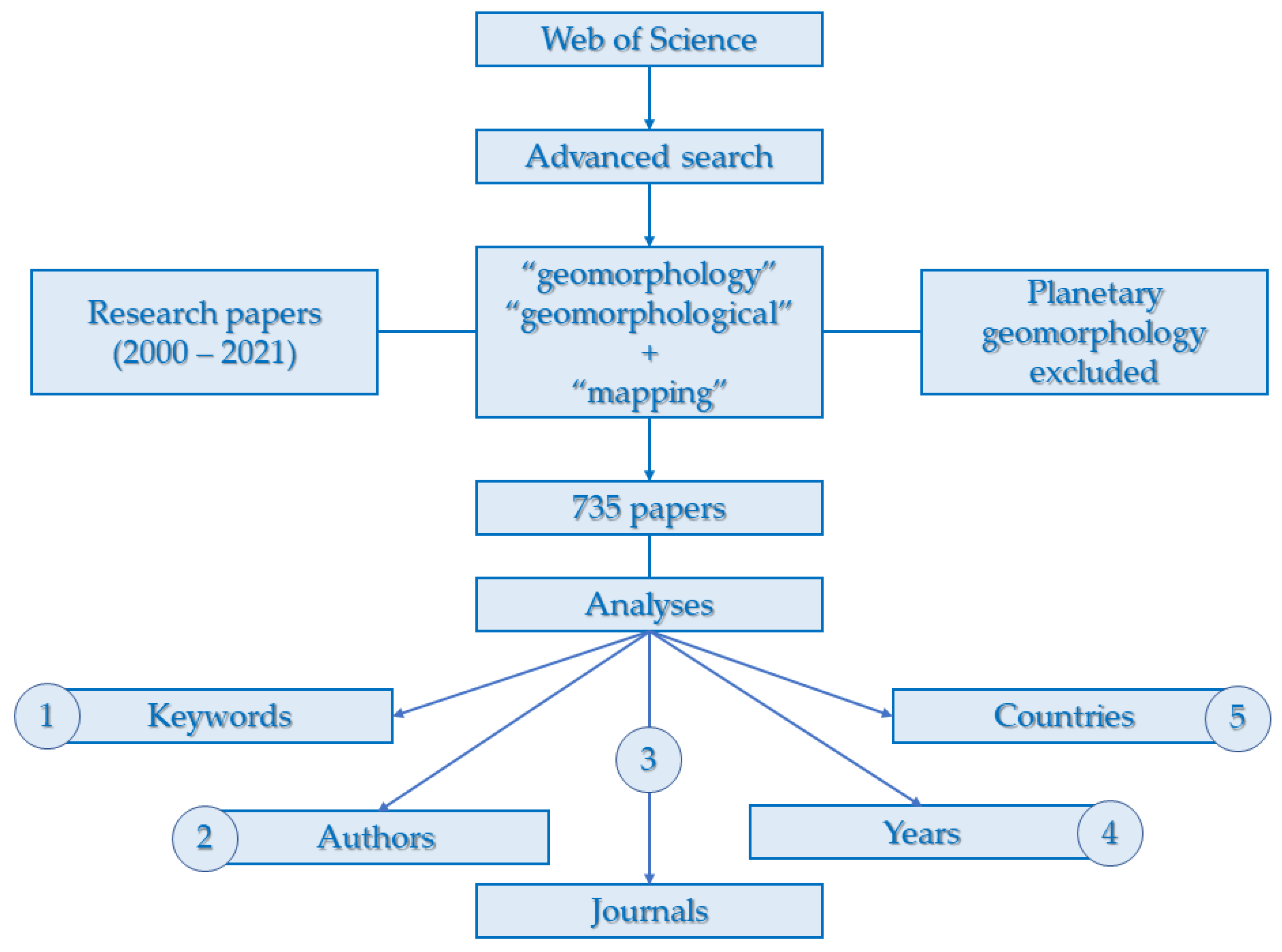
2. Materials and Methods

We conducted a bibliometric analysis of geomorphological mapping research papers published in English between 2000 and 2021. The analysis used the Web of Science (WoS) database using the Advanced search function [39,40,41]. We used the search terms “geomorphology” and “geomorphological” in combination with “mapping”. We excluded planetary geomorphology papers, as our focus was solely on terrestrial studies. The search included all papers published until the end of 2021 (Figure 1). Using the WoS database to recognize cartographic products tends to underestimate the results of geomorphological mapping worldwide, as an increasing amount of these maps support public administration planning and may not be published in WoS-classified journals.
We looked for papers with explicit indications of a place in the abstract. Papers that did not include any reference to a specific geographic location were excluded from the analysis. In total, our search yielded 735 results that met our inclusion criteria (see Supplementary Information). All papers were in English and were research papers. By exclusively utilizing English papers, we aimed to maximize the quality, accessibility, and efficiency of our analysis, while maintaining consistency and reaching a wider audience in the scientific community. To ensure the accuracy of our analysis, we used the citation and publication data provided by the Web of Science database. Our bibliometric analysis focused on several metrics, including the number of papers published each year, the distribution of papers by journal, the most common keywords used in the papers, and the most frequently cited papers in the dataset. By conducting this analysis, we aim to give lines into the state of the art of research on geomorphological mapping and foresee potential areas for future research.

3. Results and Discussion

This study aimed to conduct a bibliometric analysis of global publications about geomorphology, with the goal of mapping their locations and establishing a frequency index to identify hotspots. The study utilized a range of factors to inform its analysis, including the time gap between publications, the source of the publication, the authors of the publication, the country where the study was conducted, the country affiliation of the authors, and the keywords that appeared in the articles. The analysis revealed a serious lack of growth or incipient growth in the number of papers about geomorphological mapping between the years 2000 and 2010. However, during the next decade, from 2011 to 2021, there was a significant increase in the quantity of papers published about geomorphological mapping. This increment was particularly consistent and pronounced in the last few years of the decade.

3.1. Keywords

The study of geomorphological mapping relies heavily on the use of keywords to establish the main subject of investigation and set the direction for inquiry. This approach allows researchers to obtain a deeper understanding of the field by analyzing the trends and insights gleaned from the keywords utilized in publications on geomorphological mapping.
The use of GIS (Geographical Information Systems) technologies in modeling, visualizing, and representing these processes is also emphasized in the study. The analysis of keywords provides valuable insights into the patterns and trends into geomorphological mapping (Table 1). By understanding the most studied topics and technologies, researchers can benefit with fresh knowledge of the current state of geomorphological mapping worldwide. Thus, the use of keywords is essential to furthering our understanding of geomorphological cartography and to identifying new areas for research and exploration. With explicit use of those keywords, the present study compared the number of publications. Table 1 represents the weight of the most used keywords by their frequency.
One of the most frequently cited keywords in this analysis is “Geomorphology” (in 141 times). This indicates the vital role played by the broader field of geomorphology in shaping research in its direct mapping. Other commonly cited keywords include “geomorphological mapping”, “glacial geomorphology”, “Remote Sensing”, “Light Detection and Ranging (LiDAR)”, “Geographic Information Systems (GIS)”, “DEM”, and “Landslides”. The prominence of GIS technologies and hydrometeorological events in the study is noteworthy.
The combination of remote sensing, LiDAR, DEM, and GIS allows for a synergistic approach to geomorphological mapping. Remote sensing provides broad-scale data acquisition capabilities, LiDAR offers detailed and accurate elevation information, while DEM and GIS serve as robust platforms for data integration, analysis, and visualization. Moreover, digital representation contributes to increasing the typology, quality, quantity of manageable and representable geomorphological information. Moreover, it excels in seamless integration with diverse themes across processing scales and conforms easily to international standards. This integration enhances our understanding of landscape dynamics, landform evolution, and the underlying processes shaping the Earth’s surface. Consequently, these keywords have become common in the study of geomorphological mapping due to their instrumental role in advancing the field’s capabilities and insights.
The analysis suggests that a significant focus has been placed on understanding the relationship between geomorphological processes and environmental phenomena such as floods, landslides, and erosion. Landslides, because of excessive water recharge in basins or any other system, can lead to gravitational processes, such as debris flow, rock falls, and other related events that are triggered by the impact of floods.

3.2. Authors

The contributions of authors are a critical factor in understanding the evolution of geomorphological mapping. This study identified the authors who have made significant contributions to the field by analyzing the number of publications focused on geomorphological cartography.
The results reveal that David J.A. Evans, from University of Durham of United Kingdom, is the author with the highest number of investigations, with 16 papers published about geomorphological mapping. Following closely is Francisco Gutiérrez from University of Zaragoza (13), then Professor Enrico Miccadei of the University G. d’Annunzio of Chieti Pescara with 12 publications. Xu, SY, from China, has 11 studies related to geomorphological mapping. Additionally, Frank Lehmkuhl, from Germany, Tommaso Piacentini from the University of Chieti Pescara, and the professor Mauro Soldati from the University of Modena and Reggio Emilia are also important contributors, as is Arjen P. Stroeven, professor at the University of Stockholm, who also has nine publications. Moreover, there are other key authors that are noted in Table 2. Notably, the study finds a predominance of European authors among the most prolific contributors to the field of geomorphological mapping. However, there is also significant research output from Asia, Oceania, and America (and especially Latin America) on this topic, indicating a growing interest and investment in the field of geomorphological mapping across the globe. The impact of collaborations can be seen into the plurality of people from the country of the investigation and overseas.
Therefore, the analysis of the contributions of authors provides valuable insights into the patterns and trends within the field of geomorphology (Table 2). The table presents the impact of the most productive authors, taking into consideration more than six papers related to geomorphological mapping as the initial factor. It is worth noting that while European authors currently dominate the field, research and publications in geomorphological mapping are not exclusive to Europe. Other regions, such as North America, Asia, and Oceania, also contribute significantly to the field and have their own influential authors and institutions. However, the higher concentration of publications from Europe, accounting for three-quarters of the production, contributes to the prominence of European authors in the field of geomorphological mapping.

3.3. Journals

In geomorphological mapping, the choice of the journal for publication is crucial in determining the reach and impact of research findings. This study identified the journals that have published the highest number of papers, revealing some interesting insights. The analysis reveals that Geomorphology by Elsevier (Amsterdam, The Netherlands) is the most significant journal about the discipline. It has existed since 1987, and it is a peer review journal about geomorphological topics and investigations with an H-index of 171. The scope of this journal includes geomorphic themes, tectonics, glacial processes and landforms, mass movements, slopes, weathering and soil erosion, quantitative geomorphology, and GIS applications. Moreover, it includes geomorphic hazards, planetary geomorphology, and vulcanology. The number of publications can be above and over 400 per year, showing a great production of knowledge whose intention is to provide the information to analyze the processes and the changes of landforms to a better understanding of surface Earth dynamics.
Journal of Maps is also an important house of publishing, with an H-index factor of 40, the publisher of which is Taylor and Francis, located in the United Kingdom. It has been publishing since 2005, producing more than a hundred papers annually, concerning social and physical processes that take place on a geographical scale. Furthermore, the study found that several other journals have also made significant contributions to the field of geomorphological mapping, but with less impact. Quaternary Science Review, Earth Surface, Processes and Landforms, and Geografia Fisica e Dinamica Quaternaria have each published several papers on geomorphological mapping topics, demonstrating a diverse range of outlets for researchers to publish their findings.
The study findings highlight the value of journal selection in shaping the reach and impact of research in the field of geomorphology (Table 3). While some journals dominate in terms of the number of papers published, there are also several other journals that have made notable contributions to the field. By identifying the most prolific journals, researchers can gain a better understanding of where to focus their efforts for maximum impact and visibility. As the results show, Geomorphology and the Journal of Maps lead the number of publications about geomorphological research worldwide by a large margin compared to the rest of geomorphological mapping related journals.
These journals exhibit a specialized focus on geomorphology, making them highly attractive to researchers specializing in the field and seeking to contribute to the advancement of knowledge in geomorphological mapping. Renowned for their strong reputation and wide recognition within the geomorphology community, these journals maintain rigorous peer-review processes and uphold high standards for publishing scientific research. Their consistent demonstration of high impact factors signifies their influence and prominence in the scientific community. Moreover, the selection of these journals may also reflect the geographic breadth of published research in geomorphological mapping, as this field often intersects with other disciplines like geology, geography, environmental sciences, and remote sensing. The interdisciplinary nature of geomorphological mapping research is thus supported by these chosen journals, fostering collaboration, and facilitating the exchange of knowledge across diverse disciplines.

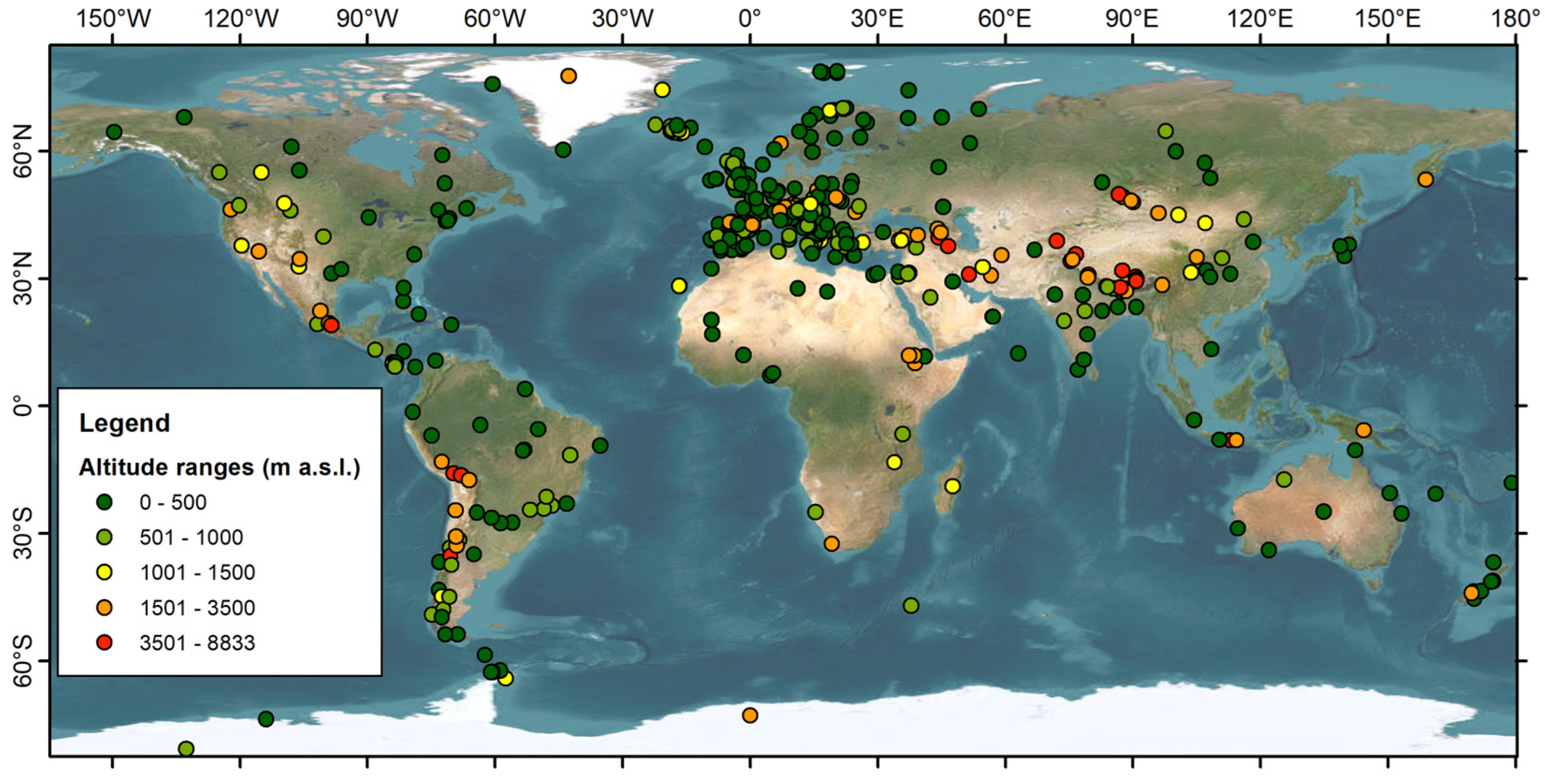
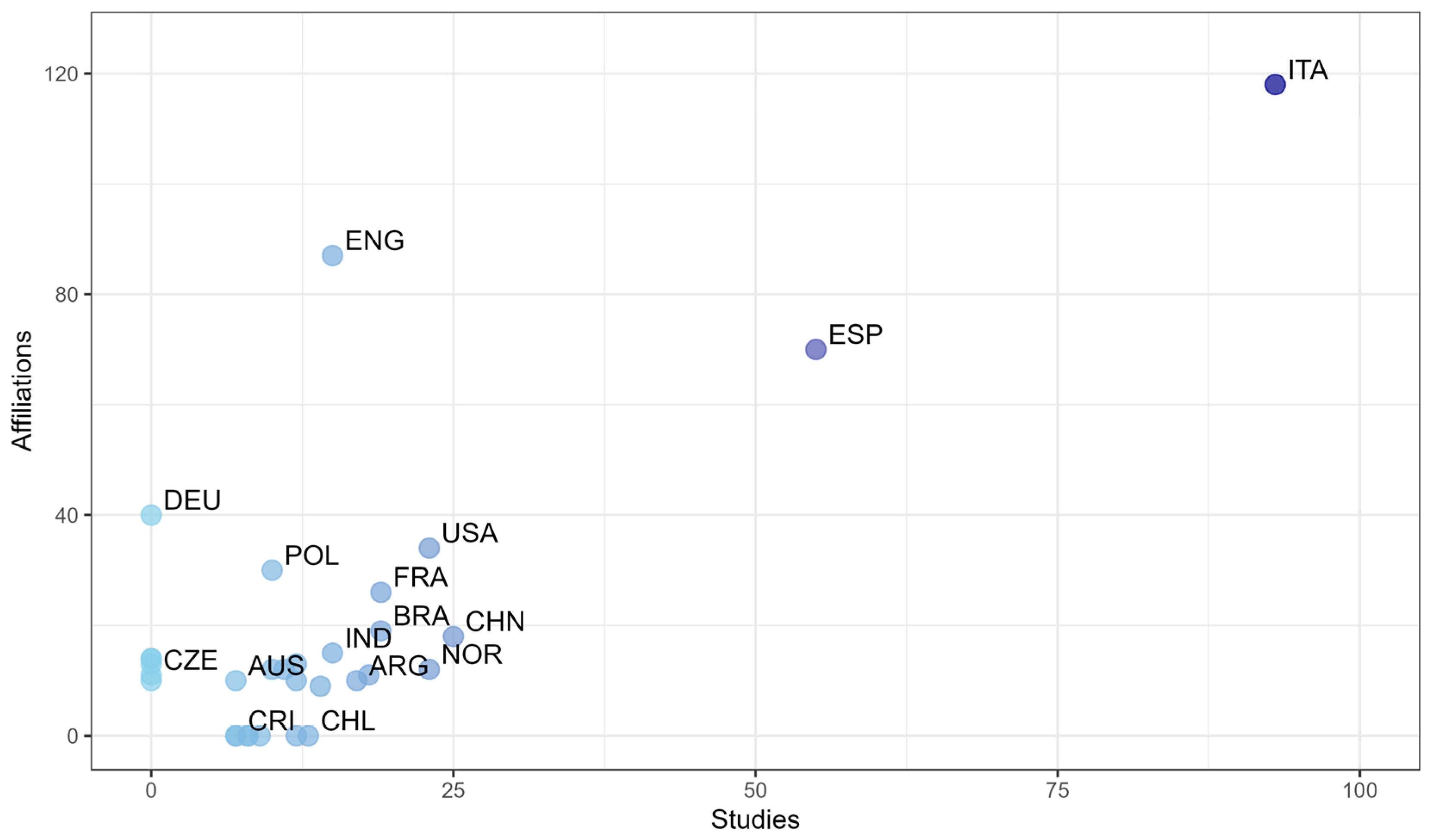
3.4. Country (Publication and Affiliation)
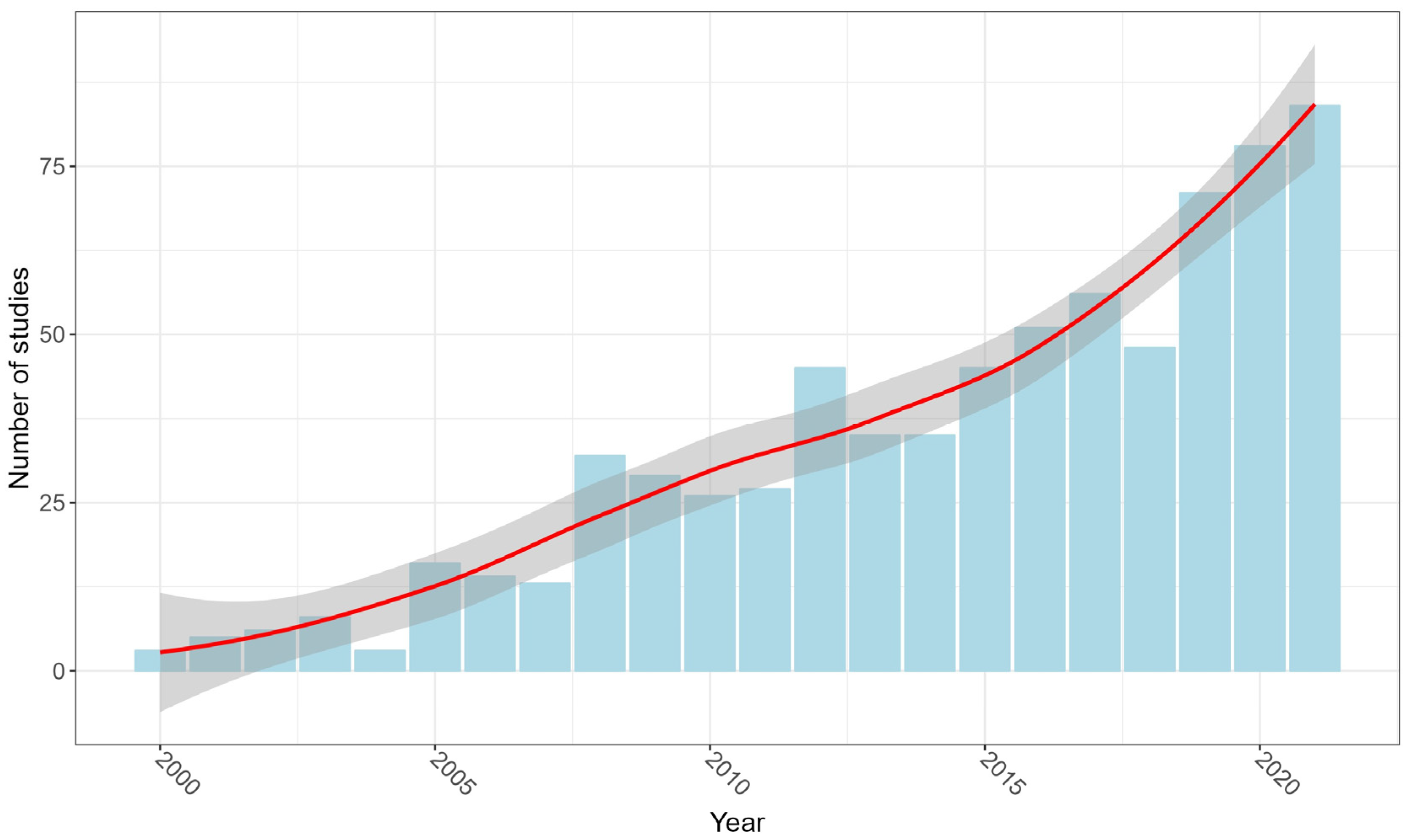
Research on geomorphological mapping is carried out worldwide, but it is highly concentrated in certain areas, with Europe leading the way as the region with the highest number of studies (74.5%), followed by America (12.5%), Asia (9.5%), Oceania (2%), and Africa (1.5%). Italy, Spain, and China are the top three countries with the most extensive research on geomorphological mapping (Figure 2). Interestingly, while Italy tops the list in number of studies, the number of times a paper is cited does not necessarily align with the number of studies produced by a country. For instance, Italy is the most important country in terms of citation, but England, Spain, and Germany follow closely behind. It indicates that the linkage between research production and affiliation is not conclusive, and other factors may come into play, such as funding opportunities or availability of resources.
Italy, Spain, and China are among the leading countries in the production of geomorphological mapping research papers for several reasons. Firstly, Italy and Spain are countries with a rich geological and geomorphological heritage, with a diverse range of landscapes, geological formations, and landforms. This natural diversity and complexity of the terrain provides researchers with a wide range of subjects for study and investigation. Furthermore, Italy and Spain have a long tradition of research in the field of geology and geomorphology, with well-established research institutions and universities that are active in this field. This has created a favorable environment for the growth of research and scientific collaboration, increasing geomorphological mapping publications. Similarly, China has a vast territory with diverse geographical landscapes, including high mountains, deserts, and plains, providing abundant resources for geomorphological mapping research. The country has invested heavily in research and development, including in the field of geosciences, which is linked with more publications in recent years. Moreover, the advancement of technology with the large application of Geographic Information Systems (GIS) and Remote Sensing, has enhanced the accessibility to remote areas and increased the accuracy and precision of research in the field of geomorphological mapping, which has benefited all countries. The natural diversity of the terrain, the long tradition of research, the investment in research and development, and the advancements in technology have contributed to the leadership of Italy, Spain, and China in the production of geomorphological cartography investigations.
To better understand the distribution of geomorphology studies, we mapped these sites worldwide, classified by altitude (Table 4). The map reveals that most of the studies have been conducted principally in Europe, below 2000 m above sea level (Figure 2). They were carried out on diverse topics such as glacial or paleoglacial geomorphology, fluvial geomorphology, coastal geomorphology, and environmental sciences. Europe offers a diverse range of landforms and geomorphological features within this elevation range, making it an ideal location for studying various aspects of geomorphology and environmental sciences. Additionally, Europe has a long history of scientific research and well-established academic institutions, which may have contributed to the concentration of studies in this region [3]. Then, in Southern Asia, those works have been conducted at different altitude ranges, in eolian and fluvial geomorphology, but in the United States roughly all the studies were conducted at low altitude with regard to fluvial, glacial, and coastal geomorphology. In South America, most of the studies are in Brazil, primarily at low altitudes and centered on environmental sciences, dendrogeomorphology, and sedimentary formations, while in the Andes chain of mountains, there are more studies across all altitude ranges. In Central and North America, the variety of studies diminishes, but the number of investigations is still significant. Surprisingly, even in the polar regions, where environmental conditions can be extreme and challenging to conduct research, there are a few studies. As a result, this information provides valuable insights into the distribution of geomorphology studies worldwide, highlighting areas where research is concentrated and underscoring the need for further investigation in other regions. Moreover, it is important to acknowledge the need for further research in other regions and at higher elevations to obtain a more comprehensive understanding of global geomorphological processes and their implications.
The difference between the country of the study and the country affiliation is the source of the funding for the investigation, the institution that leads the study. As Figure 3 demonstrates, the importance of country of affiliation is not always related to the countries where investigation takes place. For example, China is in the top 3 countries by number of studies. However, by country of affiliation, it is located in 10th place. Brazil and Argentina, recognized as developing countries, figure as 6th and 9th, respectively, in number of studies; thus, in country of affiliation they are 7th and 20th. Norway is another great example; the country ranks 4th in terms of studies due to its abundance of glacial knowledge and other geomorphological formations found in its landforms, but its affiliation is far from being significant, in 18th place. Germany also invests significant amounts in geomorphological mapping studies, being the 4th country in terms of affiliation, but it does not have many studies on its territory.

3.5. Years

The analysis of the data reveals a marked growth in geomorphological mapping publications over the considered years. The data from 2001 to 2021 show that there is a clear trend of increase in the total number of publications. In the first decade, from 2001 to 2010, there was a relatively low production, with no more than 155 papers published during this period. However, in the following decade, from 2011 to 2021, there was a substantial proliferation in the research products, with a total of 580 papers published during this period.
This increase in the number of publications can be linked to several factors, comprising the impact of the technological revolution on GIS, cartography, and transportation, which has made it easier to access and explore remote sites. It is also likely that the increase in funding for research in this field has contributed to the growth in the number of publications. Despite the overall trend of growth, there have also been some periods of steadiness during the 2010 decade. For example, there was a brief period of growth between 2000 and 2004, followed by a period of stability until 2007, after which there was a marked growth in the number of articles published. However, in the following years, the number of publications remained stable at around 35 papers per year, perhaps associated with the 2008 crisis.
Towards the end of the decade, the number of publications on geomorphological mapping increased again, reaching a peak of 78 papers. Although there have been some periods of steadiness in the past, the data show that there has been a clear trend of growth in the number of publications on geomorphological mapping over the years. More specifically, between 2005 and 2007, 2008 and 2011, and 2013 and 2014 there were steadiness periods. However, between 2004 and 2005, there was a huge growth in the total published papers, as well as in the 2007 and 2008 period and the 2011 and 2012 period. Since 2015, the number of publications annually has been historically important, reaching 45 papers, and, excepting 2018, the number continuously increased until the last year of the study, reaching the peak level of 84 papers.
The data analysis shows a clear trend of growth in the number of publications on geomorphological mapping over the years (R2 = 0.91), with some periods of steadiness (Figure 4). The increase in publications can be assigned to various aspects, which include technological advancements and increased funding for research. By unraveling these intricate patterns, researchers gain invaluable insights into the ever-evolving landscape of geomorphological mapping worldwide. This not only enriches our understanding of the subject but also uncovers potential research opportunities that lay the foundation for exciting scientific adventures yet to come.
It is important to note that while Europe has a higher proportion of geomorphological mapping studies, valuable research is being conducted in other continents as well. The varying distribution is influenced by a combination of historical, geographic, infrastructural, and socio-economic factors. Promoting collaboration, knowledge sharing, and enhancing research infrastructure in regions with lower representation can help bridge the gap and foster a more equitable distribution of geomorphological mapping studies worldwide.

4. Conclusions

This study highlights the significant influence of investment in geomorphological mapping as a crucial factor in promoting research and knowledge production in Earth Sciences. Over the last two decades, there has been a continuous increase in geomorphological mapping research due to the impact of data analysis, collaboration between institutions and countries, and the rapid development of GIS technologies. These factors have justified the sustained investment in geomorphology cartography research by some countries. While most of the principal authors in this field are from European universities or research centers, there are also some notable researchers from Latin America and Asia who are contributing to geomorphological mapping. Furthermore, when examining the spatial and geographical distribution of research, it becomes clear that there is a concentration of research in Europe, particularly at low altitudes worldwide. Overall, this study demonstrates the vital importance of investment in geomorphological cartography research and the benefits of collaboration between institutions and countries to advance knowledge and understanding of this field. Additionally, it highlights the need for greater diversity in the geographic and cultural backgrounds of researchers in this field to ensure a more comprehensive and inclusive approach to research.

Supplementary Materials

The following supporting information can be downloaded at: https://www.mdpi.com/2673-7086/3/3/32/s1.

Author Contributions

Conceptualization, A.Q.-R.; Methodology, A.Q.-R.; Formal analysis, A.Q.-R. and M.P.-R.; Investigation, A.Q.-R.; Data curation, A.Q.-R.; Writing—original draft, A.Q.-R. and M.P.-R.; Writing—review and editing, A.Q.-R. and M.P.-R.; Visualization, A.Q.-R. and M.P.-R.; Project administration, A.Q.-R. All authors have read and agreed to the published version of the manuscript.

Funding

Project C1212 Geomorfología Aplicada y Riesgos Naturales en América Central, Vicerrectoría de Investigación, Universidad de Costa Rica.

Data Availability Statement

Data will be shared under request.

Acknowledgments

Hugo Rodríguez-Bolaños for his assistance processing the initial database used for this manuscript.

Conflicts of Interest

The authors declare no conflict of interest.

References

  1. Magliulo, P.; Valente, A. GIS-Based geomorphological map of the Calore River floodplain near Benevento (Southern Italy) overflooded by the 15th October 2015 event. Water 2020, 12, 148. [Google Scholar] [CrossRef]
  2. Woodroffe, C.D. Coasts: Geomorphology and Environment; Cambridge University Press: Cambridge, UK, 2002. [Google Scholar]
  3. Campos, N.; Quesada-Román, A.; Granados-Bolaños, S. Mapping Mountain Landforms and Its Dynamics: Study Cases in Tropical Environments. Appl. Sci. 2022, 12, 10843. [Google Scholar] [CrossRef]
  4. Slaymaker, O.; Spencer, T.; Embleton-Hamann, C. Recasting geomorphology as a landscape science. Geomorphology 2021, 384, 107723. [Google Scholar] [CrossRef]
  5. Tarolli, P.; Borga, M.; Dalla Fontana, G. Geomorphological mapping: A review of approaches and applications in Italy. Geogr. Fis. Din. Quat. 2014, 37, 167–178. [Google Scholar]
  6. Boothroyd, R.J.; Williams, R.D.; Hoey, T.B.; Barrett, B.; Prasojo, O.A. Applications of Google Earth Engine in fluvial geomorphology for detecting river channel change. Wiley Interdiscip. Rev. Water 2021, 8, e21496. [Google Scholar] [CrossRef]
  7. Giaccone, E.; Oriani, F.; Tonini, M.; Lambiel, C.; Mariéthoz, G. Using data-driven algorithms for semi-automated geomorphological mapping. Stoch. Environ. Res. Risk Assess. 2022, 36, 2115–2131. [Google Scholar] [CrossRef]
  8. Dramis, F.; Guida, D.; Cestari, A. Nature and Aims of Geomorphological Mapping. In Developments in Earth Surface Processes; Elsevier: Amsterdam, The Netherlands, 2011; Volume 15. [Google Scholar]
  9. Burt, T.P.; Goudie, A.S.; Viles, H.A. (Eds.) The History of the Study of Landforms or the Development of Geomorphology: Volume 5: Geomorphology in the Second Half of the Twentieth Century; Geological Society of London Memoirs: London, UK, 2022; Volume 58. [Google Scholar]
  10. Goudie, A.S.; Burt, T.P.; Viles, H.A. The global transformation of geomorphology. Geol. Soc. Lond. Mem. 2022, 58, 1–17. [Google Scholar] [CrossRef]
  11. Shroder, J.F. Treatise on Geomorphology; Academic Press: New York, NY, USA, 2013; Volume 1. [Google Scholar]
  12. Wu, X.; Chen, X.; Zhan, F.B.; Liu, Z.; Zhou, S.; Yu, H.; Zhang, W.; Guo, F.; Chen, X.; Guo, J. Global Research Trends in Landslides during 1991–2014: A Bibliometric Analysis. Landslides 2015, 12, 1215–1226. [Google Scholar] [CrossRef]
  13. Carrión-Mero, P.; Montalván-Burbano, N.; Paz-Salas, N.; Morante-Carballo, F. Volcanic Geomorphology: A Review of Worldwide Research. Geosciences 2020, 10, 347. [Google Scholar] [CrossRef]
  14. Vivero, S.; Bodin, X.; Farías-Barahona, D.; MacDonell, S.; Schaffer, N.; Robson, B.A.; Lambiel, C. Combination of aerial, satellite, and UAV photogrammetry for quantifying rock glacier kinematics in the Dry Andes of Chile (30 S) since the 1950s. Front. Remote Sens. 2021, 2, 784015. [Google Scholar] [CrossRef]
  15. Quesada-Román, A. Landslides and Floods Zonation Using Geomorphological Analyses in a Dynamic Catchment of Costa Rica. Rev. Cartogr. 2021, 102, 125–138. [Google Scholar]
  16. Lee, E.M. Geomorphological mapping. Geol. Soc. Lond. Eng. Geol. Spec. Publ. 2001, 18, 53–56. [Google Scholar] [CrossRef]
  17. Quesada-Román, A.; Quirós-Arias, L.; Zamora-Pereira, J.C. Interactions between Geomorphology and Production Chain of High-Quality Coffee in Costa Rica. Sustainability 2022, 14, 5265. [Google Scholar] [CrossRef]
  18. Smith, M.J.; Pain, C.F. Geomorphological mapping. In The SAGE Handbook of Geomorphology; SAGE Publications: London, UK, 2011; pp. 142–153. [Google Scholar]
  19. Bishop, M.P.; James, L.A.; Shroder, J.F., Jr.; Walsh, S.J. Geospatial technologies and digital geomorphological mapping: Concepts, issues and research. Geomorphology 2012, 137, 5–26. [Google Scholar] [CrossRef]
  20. Fuller, I.C.; Gilvear, D.J.; Thoms, M.C.; Death, R.G. Framing Resilience for River Geomorphology: Reinventing the Wheel? River Res. Appl. 2019, 35, 91–106. [Google Scholar] [CrossRef]
  21. Tarolli, P.; Cao, W.; Sofia, G.; Evans, D.; Ellis, E.C. From Features to Fingerprints: A General Diagnostic Framework for Anthropogenic Geomorphology. Prog. Phys. Geogr. Earth Environ. 2019, 43, 95–128. [Google Scholar] [CrossRef]
  22. Cheng, X.; Li, J.; Guo, X.; Yang, X.; Sun, W. A Review of Remote Sensing Applications in Geomorphology. J. Mt. Sci. 2020, 17, 1531–1552. [Google Scholar]
  23. Liu, Z.; Zhou, S.; Yu, H.; Zhang, W.; Guo, F.; Chen, X.; Guo, J. Quantitative Analysis of Tectonic Geomorphology Research Based on Web of Science from 1981 to 2021. Remote Sens. 2022, 14, 5227. [Google Scholar] [CrossRef]
  24. Tarolli, P.; Mudd, S.M. Remote Sensing of Geomorphology, 1st ed.; Elsevier: Amsterdam, The Netherlands, 2020. [Google Scholar]
  25. Quesada-Román, A.; Vargas-Sanabria, D. A geomorphometric model to determine topographic parameters controlling wildfires occurrence in tropical dry forests. J. Arid. Environ. 2022, 198, 104674. [Google Scholar] [CrossRef]
  26. Bocco, G.; Mendoza, M.; Velázquez, A. Remote sensing and GIS-based regional geomorphological mapping—A tool for land use planning in developing countries. Geomorphology 2001, 39, 211–219. [Google Scholar] [CrossRef]
  27. Dadson, S.J. Geomorphology and Earth System Science. Geol. Soc. Lond. Mem. 2022, 58, 99–108. [Google Scholar] [CrossRef]
  28. Viles, H. Biogeomorphology: Past, Present and Future. Geomorphology 2020, 366, 106809. [Google Scholar] [CrossRef]
  29. Deng, Q.; Li, Y.; Chen, X. The Research on the Development of Geomorphology in China. J. Geogr. Sci. 2018, 28, 1469–1480. [Google Scholar]
  30. Quesada-Román, A. Disaster Risk Assessment of Informal Settlements in the Global South. Sustainability 2022, 14, 10261. [Google Scholar] [CrossRef]
  31. Quesada-Román, A. Geomorphology of the Guacimal River Catchment, Costa Rica. J. Geogr. Cartogr. 2022, 5, 58–67. [Google Scholar] [CrossRef]
  32. Quesada-Román, A. Review of the Geomorphological Effects of the 1991 Limón Earthquake. Rev. Geol. Am. Cent. 2022, 65, 370–395. [Google Scholar]
  33. Das, S.; Patel, P.P.; Sengupta, S. Evaluation of different digital elevation models for analyzing drainage morphometric parameters in a mountainous terrain: A case study of the Supin–Upper Tons Basin, Indian Himalayas. SpringerPlus 2016, 5, 1544. [Google Scholar] [CrossRef]
  34. Quesada-Roman, A.; Campos, N.; Granados-Bolanos, S. Tropical Glacier Reconstructions during the Last Glacial Maximum in Costa Rica. Rev. Mex. Cienc. Geol. 2021, 38, 55–64. [Google Scholar] [CrossRef]
  35. Vandelli, V.; Ghinoi, A.; Marchetti, M.; Soldati, M. Discovery and dating of Pre-LGM deposits in a high catchment of the Dolomites (Italy): New insights on climate-related geomorphological processes during the Late Pleistocene. Geomorphology 2019, 332, 22–32. [Google Scholar]
  36. Oguchi, T. Geomorphological Debates in Japan Related to Surface Processes, Tectonics, Climate, Research Principles, and International Geomorphology. Geomorphology 2020, 366, 106805. [Google Scholar] [CrossRef]
  37. Piégay, H.; Kondolf, G.M.; Minear, J.T.; Vaudor, L. Trends in Publications in Fluvial Geomorphology over Two Decades: A Truly New Era in the Discipline Owing to Recent Technological Revolution? Geomorphology 2015, 248, 489–500. [Google Scholar] [CrossRef]
  38. Verstappen, H.T. Old and New Trends in Geomorphological and Landform Mapping. Dev. Earth Surf. Process. 2011, 15, 13–38. [Google Scholar]
  39. Nguyen, B.X.; Dinneen, J.D.; Luczak-Roesch, M. A Novel Method for Resolving and Completing Authors’ Country Affiliation Data in Bibliographic Records. J. Data Inf. Sci. 2020, 5, 97–115. [Google Scholar] [CrossRef]
  40. AlRyalat, S.A.S.; Malkawi, L.W.; Momani, S.M. Comparing Bibliometric Analysis Using PubMed, Scopus, and Web of Science Databases. J. Vis. Exp. 2019, 152, e58494. [Google Scholar]
  41. Caputo, A.; Kargina, M. A User-Friendly Method to Merge Scopus and Web of Science Data during Bibliometric Analysis. J. Mark. Anal. 2022, 10, 82–88. [Google Scholar] [CrossRef]
Figure 1. Schematic plot of the employed bibliometric method in geomorphological mapping.
Geographies 03 00032 g001
Figure 2. Global geographical distribution of geomorphological mapping studies based on altitude.
Geographies 03 00032 g002
Figure 3. Number of published papers by country of affiliations and studies in geomorphological mapping.
Geographies 03 00032 g003
Figure 4. Number of publications per year on geomorphological mapping.
Geographies 03 00032 g004
Table 1. Top nineteen keywords most used in geomophological mapping papers.
RankKeywordNP
1Geomorphology141
2Geomorphological mapping82
3Glacial geomorphology52
4Remote sensing48
5GIS39
6DEM33
7Lidar28
8Landslides25
9Fluvial geomorphology20
10Mapping20
11Holocene15
12Karst15
13Landslide15
14Coastal geomorphology14
15Quaternary13
16Tectonic Geomorphology13
17Palaeohydrology12
18Geomorphometry11
19Landscape evolution11
NP: number of publications. This table shows the most frequent keywords in all geomorphological mapping articles.
Table 2. Top fifteen authors ranked by their number of publications (NP) in geomorphological mapping.
RankAuthorsATAFCOHI
1Evans, D.J.A.16Durham UniversityUK57
2Gutierrez, F.13Zaragoza UniversitySpain52
3Miccadei, E.12Università degli Studi “G. d’Annunzio” di Chieti PescaraItaly28
4Xu, S.Y.11Beijing Geosciences University ChinaND
5Lovell, H.10Portsmouth UniversityUK18
6Lehmkuhl, F.9RWTH Aachen UniversityGermany54
7Piacentini, T.9Università degli Studi “G. d’Annunzio” di Chieti PescaraItaly22
8Soldati, M.9Università di Modena e Reggio EmiliaItaly33
9Stroeven, A.P.9Stockholm UniversitySweden42
10Glasser, N.F.8Aberystwyth UniversityEngland64
11Jansson, K.N.8Stockholm UniversitySweden54
12Quesada-Román, A.8Universidad de Costa RicaCosta Rica26
13Stokes, C.R.8Durham UniversityUK58
14Boston, C.M.7Portsmouth UniversityUK15
15Cofaigh, C.O.7Durham UniversityUK59
Abbreviations: AT = Articles; AF = Affiliations; Co = Country; HI = H-Index, ND = No Data.
Table 3. Top twenty journals ranked by total number of publications (NP) in geomorphological mapping.
RankJournalNP
1Geomorphology231
2Journal of Maps126
3Quaternary Science Reviews17
4Earth Surface Processes and Landforms15
5Geografia Fisica e Dinamica Quaternaria13
6Journal of Coastal Research9
7Zeitschrift Fur Geomorphologie8
8Geosciences7
9Marine Geology7
10Catena6
11Journal of South American Earth Sciences6
12Natural Hazards6
13Quaterly Journal of Engineering Geology and Hydrogeology6
14Remote Sensing6
15Arabian Journal of Geosciences5
16Bulletin of the Seismological Society of America5
17Geografiska Annaler Series A- Physical Geography5
18Landslides5
19Natural Harzards and Earth System Sciences5
20Water5
Table 4. Number of geomorphological mapping studies based on its altitude.
Altitude Range (m a.s.l.)NPPercentage (%)
0 to 100043169.4
1000 to 200010216.4
2000 to 3000548.7
3000 to 4000152.4
4000 to 8833193
Total = 621 100
Disclaimer/Publisher’s Note: The statements, opinions and data contained in all publications are solely those of the individual author(s) and contributor(s) and not of MDPI and/or the editor(s). MDPI and/or the editor(s) disclaim responsibility for any injury to people or property resulting from any ideas, methods, instructions or products referred to in the content.

