Review

Real Time Mining—A Review of Developments Within the Last Decade

Faculty of Geosciences, Geoengineering and Mining, Institute of Mine Surveying and Geodesy, TU Bergakademie Freiberg, 09599 Freiberg, Germany
*
Author to whom correspondence should be addressed.
Mining 2025, 5(3), 38; https://doi.org/10.3390/mining5030038
Submission received: 15 April 2025 / Revised: 18 June 2025 / Accepted: 19 June 2025 / Published: 21 June 2025
(This article belongs to the Special Issue Mine Automation and New Technologies)

Abstract

Real-time mining (RTM) has become increasingly significant in response to the growing need for sustainable mineral resource extraction, driven by global population growth and technological progress. This innovative approach addresses critical challenges, such as declining ore grades, deeper and less accessible deposits, and rising energy costs, by integrating advanced online grade monitoring, data analysis, and process optimization. By employing real-time grade control, dynamic mine planning, and production optimization, it enhances the efficiency of resource extraction while minimizing environmental and social impacts. Originally proposed about a decade ago, RTM has gained attention for its potential to revolutionize the industry. This review examines recent advancements in closed-loop concepts, emphasizing the integration of advanced sensors and data analytics to enable continuous monitoring and adaptive decision making across the mining value chain. It highlights the role of online sensor technologies in providing high-resolution data for process optimization and evaluates various mining optimization techniques. The paper also explores data assimilation methods, such as Kalman filters and artificial intelligence (AI), showcasing their ability to continuously update models and reduce operational uncertainties. Ultimately, it proposes a comprehensive framework for adaptive, data-driven mining operations that promote sustainable development, enhance profitability, and improve decision-making capabilities.

1. Introduction

The global demand for mined resources has accelerated over the past decade, driven by population growth, technological advancements, and economic expansion By 2050, the demand for metals is projected to increase significantly, with aluminum rising by 215%, copper and nickel each by 140%, iron by 86%, zinc by 81%, and lead by 46% [1]. Metals such as copper, gold, zinc, and aluminum are essential for the renewable energy transition and achieving net-zero targets due to their critical role in decarbonization technologies, such as wind turbines, solar panels, and electric vehicles [2,3].
This escalating demand intensifies pressure on the mining sector, which faces challenges such as declining ore grades, deeper and more inaccessible deposits, and increasing energy costs. Moreover, mining activities often raise social and environmental concerns, leading to what is known as the “mineral resource dilemma”. This dilemma highlights the tension between the necessity for mineral resources to support technological and societal advancement and the reluctance to endorse mining due to its adverse impacts [4,5]. Balancing these competing interests necessitates greater transparency and sustainable practices in mining operations. The industry must optimize resource extraction while minimizing environmental footprints to meet global demands without exacerbating ecological degradation.
Traditionally, the mining industry has followed a linear value chain, comprising sequential steps from exploration to mine closure. The process begins with exploration, where data is collected to define the spatial extent, geometry, and geotechnical and hydrological conditions of potential sites using methods such as remote sensing, geological mapping, geophysics, and drilling [6]. Resource modeling then creates a 3D orebody model, classifying ore, waste, and rock types to minimize ore loss and dilution [7,8,9]. Mine planning utilizes this data to design optimal extraction sequences, involving production control and planning to ensure consistent product quality through effective blending [10,11,12].
Despite its widespread use, this linear approach has significant drawbacks. It is often subjective, time consuming, and prone to inconsistencies, especially in complex geological settings. Uncertainties in mineral deposits can lead to production deviations from expectations, as resource modeling relies on uncertain data, causing planning inaccuracies [13,14,15]. Furthermore, the traditional fragmented approach involves specialized experts working independently with minimal communication, resulting in delayed feedback and issues that surface only during operations. This lack of integration and real-time communication hinders prompt adaptation and leads to suboptimal decisions. Integrating advanced technologies and real-time data can enhance data integration and cross-phase communication, improving modeling and planning efficiency while reducing operational uncertainty [6].
To address these challenges, the concept of real-time mining (RTM) emerged about a decade ago [16]. RTM aims to optimize resource extraction and minimize environmental impacts through continuous monitoring and immediate data analysis. By employing real-time data from advanced sensors and analytics, RTM enhances process efficiency, maximizes mineral recovery, and facilitates immediate adjustments based on the latest information [17,18]. The core idea is to create a closed-loop management system where operational data feeds back into decision-making processes in real time, enabling dynamic optimization of extraction, processing, and overall efficiency. In general, key constituents of the RTM approach are advanced real-time sensors, optimization algorithms, and data assimilation. Continuous grade control becomes possible, allowing for accurate ore characterization and immediate responses to changes in ore quality [6].
Recent years have seen the emergence of megatrends that have the potential to transform the mining industry. Digital disruption, characterized by the integration of digital technologies into all aspects of operations, is reshaping traditional practices. Advanced online sensors, Internet of Things (IoT) devices, and data analytics methods, such as artificial intelligence (AI) and geostatistics, enable the collection and analysis of vast amounts of real-time data [19,20,21,22]. These innovations improve predictive maintenance, process optimization, and decision making, enhancing efficiency, safety, and sustainability. AI-driven tools also support intelligent mining systems, enabling precise ore deposit modeling, real-time monitoring, geo-metallurgical modeling, and continuous grade control [7,23,24,25,26]. Collectively, these advancements improve resource utilization, reduce environmental impacts, and promote transparency in addressing the mineral resource dilemma.
Significant advances have been made in key constituents of the RTM approach over the past decade, particularly in sensor development and data analytics. Cutting-edge sensors provide near-continuous monitoring of critical indicators, such as ore grade and environmental contamination, enabling early risk detection and timely interventions [6,21,27,28,29,30]. Additionally, data analytics techniques, including AI, geostatistics, and Kalman filters, have enhanced data interpretation, facilitating real-time updates to grade control models, optimizing extraction processes, and reducing ore dilution [16,31,32,33].
Despite its potential, the full RTM concept remains largely theoretical, with limited practical implementation due to technological and operational barriers. Factors such as inadequate sensor designs for field applications, high initial costs, and the need to demonstrate practical utility have hindered widespread adoption. Integrating advanced sensors into the harsh and variable conditions of mining environments poses significant technical challenges that demand robust and durable designs [21]. The technology readiness level (TRL) framework, which ranges from basic principles (TRL 1) to fully operational systems (TRL 9), highlights the substantial gap between research and application. To date, no operational mine has fully integrated RTM approaches, underscoring the low TRL status of these technologies. This status emphasizes the considerable development and testing required to advance key constituents of the RTM approach toward practical deployment.
Additionally, developing real-time data processing algorithms capable of handling the volume and complexity of mining data in operational settings is still underway [7,34]. The absence of pilot projects and field demonstrations means that mining companies are hesitant to invest in key constituents of the RTM approach without clear evidence of their practical benefits and return on investment. Elevating key constituents of the RTM approach to higher TRL levels through collaborative efforts between researchers, technology developers, and industry stakeholders is essential for bridging the gap between concept and practical application.
The primary objective of this review paper is to evaluate the advancements in key constituents of the RTM approach over the past decade, identify the barriers preventing their practical implementation, and propose strategies to bridge the gap between research and industry application. By analyzing existing literature and technological developments, this paper aims to provide insights into transitioning RTM from theoretical frameworks to practical, large-scale operations that meet global demands and optimize ore extraction processes.

2. The RTM Concept

Over the past decade, the concept of RTM has emerged as a transformative approach in the mining industry, shifting from traditional discontinuous and intermittent monitoring systems to continuous process and quality management frameworks. RTM integrates a real-time feedback control loop that immediately links live data collected at the mining face, throughout material handling and processing, with an updatable sequential resource model (see Figure 1) [6]. This integration facilitates near-real-time optimization of long-term planning, short-term sequencing, and production control, providing critical insights to improve efficiency and reduce deviations from production targets.
A closed-loop mineral resource management (CLRM) system in RTM builds a model-based representation of the real system that is continuously updated as new data become available. It builds upon several core elements, as illustrated in Figure 2. These are sensor networks for production monitoring, system models, optimization algorithms for decision support, and data assimilation for real-time model update. Together, these interconnected elements provide a comprehensive, data-driven approach to optimizing mining operations in real time.
The “real system” in this context embodies the physical mining environment, which includes activities such as drilling, blasting, hauling, and processing that interact directly with the orebody. The effectiveness of these activities is influenced by control variables, such as equipment schedules and mine plans. The system is also influenced by inherent variability and uncertainty, which is depicted as “noise” in the figure.
Production monitoring involves sensors that collect real-time data during production. These sensors might measure ore grades, production rates, or equipment performance. Such monitoring can also include higher-level tasks, such as interpreting geological information or assessing grade control sampling. This process provides essential feedback about ore characteristics such as grade and hardness. The concept of “noise” here refers to measurement uncertainties and discrepancies in material tracking. These models are developed and continuously updated using data such as exploration data, geological interpretation, geodesy data, and grade control data.
The system models, including resource and grade control models, provide a mathematical or computational representation of the mining system. Resource models estimate the quantity and quality of mineral resources, while grade control models are focused on the quality of the ore being extracted. Due to the uncertainty inherent in subsurface geology, multiple models are typically created to provide estimates of mineral distribution and orebody characteristics and its uncertainty, using data, such as exploration results, geological assessments, and grade control measurements.
Within the closed-loop management system, optimization algorithms play a critical role in decision making. These algorithms generate efficient mine plans and production control strategies, optimizing parameters, such as equipment schedules and production targets. Optimizers work on different planning horizons, from short-term tasks, such as daily equipment scheduling, to long-term plans, such as designing pushbacks. The “blue loop” in the figure represents the continuous optimization process, where real-time data from production monitoring is used to refine mine planning and operations.
Data assimilation is the process of updating the system models to accurately reflect the performance of the real system. Through advanced data analytics, such as AI and geostatistics techniques, data assimilation reconciles discrepancies between model predictions and observed outcomes, thus enhancing model reliability. Whenever measured outputs deviate from model predictions, the model parameters are updated to reduce these discrepancies, thereby improving the predictive accuracy of the models. This process also helps manage the noise present in both control inputs and system outputs. The red loop in the figure represents this iterative updating of system models, which is informed by real-time production data.
The integration of these elements into a closed-loop mineral resource management system is designed to address uncertainties and improve operational outcomes. By combining real-time monitoring, system models, optimization algorithms, and data assimilation, the system ensures that physical operations are continuously observed, and the data gathered is used to enhance planning and operations. This closed-loop structure facilitates adaptive, data-driven decision making, which leads to increased resource recovery, reduced waste, and minimized operational risks.

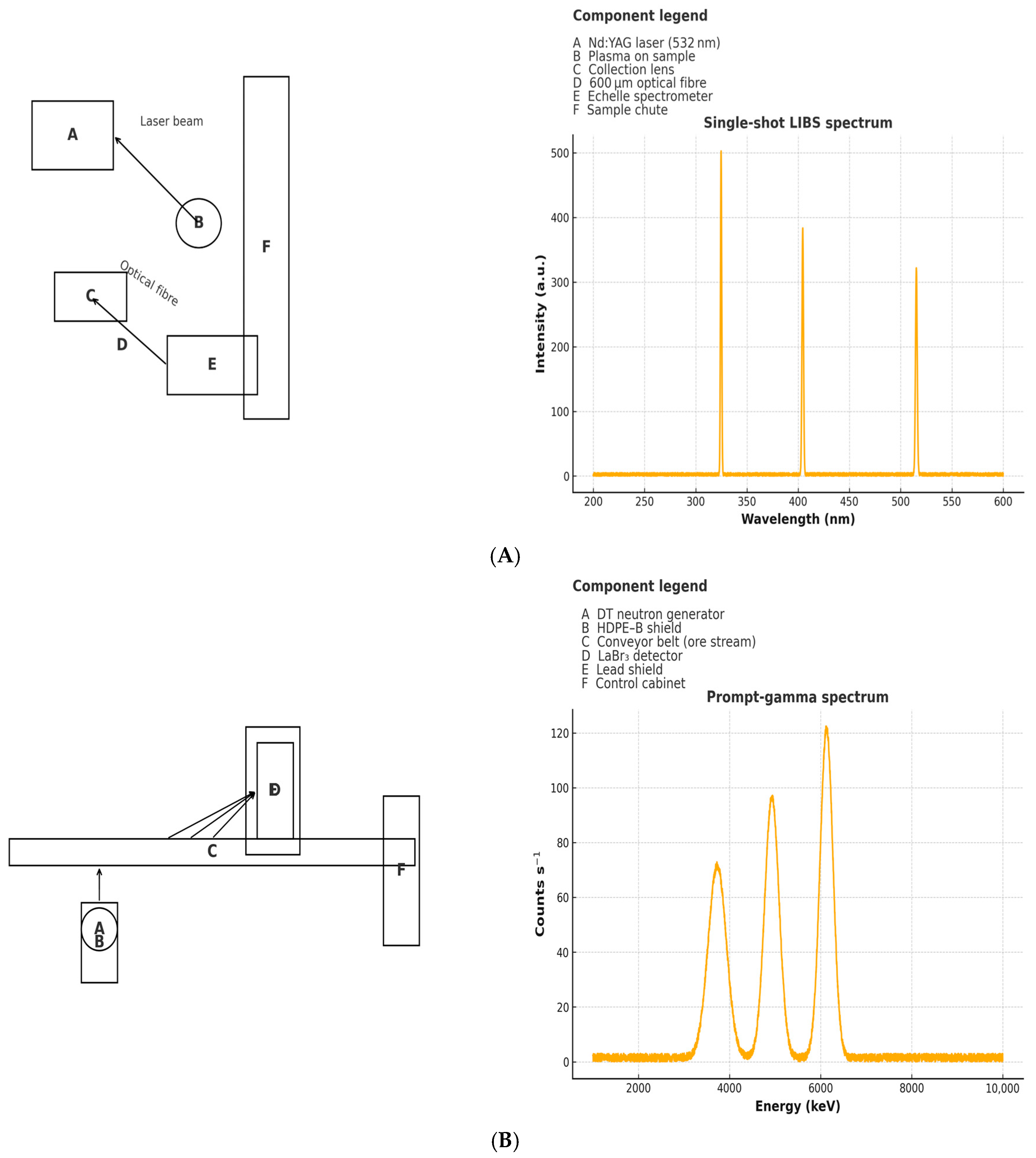
3. Transformation in Mining Operations Through Sensors

Sensor technologies have transformed the mining industry by offering deep insights into material properties, providing rich qualitative, quantitative, and semi-quantitative data across various dimensions, such as geochemistry, mineralogy, and texture [21]. By operating within specific electromagnetic spectrums, sensors offer unique chemical information that is critical for improving mining operations. Additionally, integrating technologies such as belt scales and geometrical sensors further optimizes process efficiency and ensures operational accuracy.
Sensors enhance efficiency and accuracy across different stages of mining. During exploration, sensors reduce costs by minimizing the need for extensive physical sampling and costly laboratory tests. With real-time data, decisions can be made more swiftly, expediting the exploration process. The high-resolution data from sensors helps precisely determine ore grades and other crucial factors, thereby defining resources with greater accuracy.
In the production and grade control stage, sensors monitor ore extraction in real time, ensuring adherence to the production plan, minimizing deviations, and distinguishing accurately between ore and waste. This precision prevents costly errors, such as processing waste or discarding valuable ore, leading to improved operational efficiency and reduced equipment downtime.
In pre-sorting or pre-upgrading of materials along the production process, sensors play a key role in eliminating waste and low-grade material before reaching the processing plant, thereby simplifying the subsequent processes and making them more energy and cost efficient. In the post-stockpile and pre-processing stages, sensors further refine the material by optimizing feed quality, which helps operators increase recovery rates and control costs.
During post-processing and quality control, sensors provide real-time feedback on product quality, allowing immediate adjustments to meet customer specifications. This enhances product value, reduces penalties for off-spec materials, and ensures customer satisfaction.
By integrating sensors at each stage, mining operations are optimized for precision, efficiency, and cost effectiveness, ultimately improving both financial performance and product quality [20]. Table 1 highlights the different impacts of sensors on mining operations.
In contemporary mining operations, the adoption of advanced sensor technologies has resulted in a rich data ecosystem, enabling continuous process monitoring and optimization. One example is measurement while drilling (MWD), an online data recording technology used to optimize blast patterns based on geomechanical properties of rock masses [36,37]. MWD data facilitates the classification of rock benches by blastability, allowing targeted blast optimization that enhances mine-to-mill (M2M) efficiency [38,39]. This M2M optimization is a holistic, data-driven approach that integrates drilling, blasting, and downstream processing operations to maximize overall mining efficiency and productivity [40,41,42].
Another advanced technology is prompt in situ neutron activation analysis (PGNAA), which serves as an elemental analyzer for real-time composition measurement of primary crushed material, significantly enhancing ore evaluation [43]. Fast neutrons from a source, such as Californium-252, interact with atomic nuclei in the mining medium, producing thermal neutrons that emit prompt in situ rays. The intensity and energy of these in situ rays are analyzed to determine the specific elements present, providing rapid, in situ analysis that eliminates the need for physical sampling and reduces errors [44].
Additionally, several emerging sensor technologies, including hyperspectral imaging, infrared technologies, Raman spectroscopy, laser-induced breakdown spectroscopy (LIBS), and light detection and ranging (LiDAR), are transforming raw material characterization across broad spatial and temporal scales [45].
Raman spectroscopy is particularly effective for identifying mineral compositions by detecting vibrational modes of molecules. For instance, it reveals microstructural features of carbonaceous materials through identifying the D (disorder) and G (graphitic) bands, which relate to the degree of crystallinity. Raman spectroscopy is advantageous as it requires minimal sample preparation and enables in-line characterization of materials [46]. The use of wide area illumination (WAI) probes enhances its accuracy in analyzing heterogeneous materials, making it suitable for industrial applications, including mineralogy [47].
LIBS is an advanced analytical technique used for the characterization of raw materials by providing elemental compositions based on plasma emission [48]. Similar to how hyperspectral sensors analyze a wide range of the electromagnetic spectrum for identifying minerals to generate a plasma from the surface of a sample. This plasma emits light at wavelengths unique to the elements within the sample, which are then collected and analyzed. The laser operates typically at 1064 nm, and the spectral range covered by LIBS usually spans the ultraviolet (UV) to visible regions, which includes most elements of the periodic table. LIBS is highly effective for rapid, in situ identification of both major and trace elements in raw materials. For instance, LIBS is capable of detecting elements, such as Si, Al, Fe, Ca, Na, and Mg, as well as trace elements, such as Li, which are difficult to detect using other portable instruments. The emitted light is collected and analyzed to provide real-time data that aids in material characterization. LIBS features several advantages, including the lack of sample preparation, making it particularly useful for field analysis and geological exploration. It also allows for micro-scale spatial analysis, depth profiling, and the detection of elements with low atomic numbers, which are key for understanding mineral compositions and geological histories [49].
In addition, LIBS provides the flexibility of working in challenging field environments due to its ability to operate in different atmospheric conditions, including open-path and stand-off configurations. These features enable it to characterize heterogeneous materials, such as geological samples and archaeological artifacts, by collecting elemental data from multiple spots on the surface and averaging them for comprehensive analysis [50].
Recent advancements in LIBS technology have enhanced its application in geology and mining, particularly for in situ and real-time elemental analysis of raw materials. Innovations, such as improved spectrometer designs and adaptive calibration techniques enable high-resolution characterization of heterogeneous geological samples and mineral ores. These developments address challenges such as matrix effects and enhance LIBS’ accuracy and repeatability in harsh field conditions [51,52]. Furthermore, LIBS’s high-resolution capabilities facilitate the detection of elements, including rare earth elements and toxic components, in complex samples, such as mining waste, solidifying its role in raw material characterization and monitoring [53].
The spectra and prompt gamma peaks shown in Figure 3 are entirely synthetic and were generated solely for illustrative purposes. In Figure 3A, a 532 nm Nd: YAG laser pulse produces a micro-plasma on the sample; the emitted light is collected through a 600 µm optical fiber and analyzed with an echelle spectrometer, yielding an exemplary single-shot LIBS spectrum with discrete elemental lines. Figure 3B depicts the PGNAA arrangement, where a DT neutron source irradiates ore on a moving conveyor and the resulting prompt γ-rays are detected by a LaBr₃ scintillator behind an HDPE shield, producing the illustrative multi-keV energy peaks presented.
LiDAR is an active remote sensing technology used to characterize raw materials by providing detailed geometric and radiometric information through the use of laser pulses. LiDAR works by emitting laser pulses at different wavelengths and then detecting the reflected backscatter from target objects to obtain spatial information in the form of point clouds. It is capable of capturing 3D geometric information with high accuracy [54,55,56]. Multispectral LiDAR (MSL) systems combine both spectral and geometric data, which is particularly beneficial for characterizing complex materials in diverse conditions. MSL operates in multiple spectral channels, typically including visible to short-wave infrared (SWIR) wavelengths. These channels provide a combination of height and intensity data that enables precise classification of minerals and geological features based on their reflectance characteristics [57,58]. As illustrated in recent studies, MSL sensors can collect both spatial and spectral information, allowing for the efficient classification of rock surfaces and the identification of subtle mineral variations [59].
In addition to these advanced sensor technologies, several other sensors are widely used in mining, particularly in material characterization, resource evaluation, and decision making throughout the value chain. RGB sensors are frequently used for color detection and qualitative analysis in mineralogical applications. These sensors capture visible light in three bands (red, green, and blue) and are particularly useful for recognizing minerals with distinct colors and textures, making them valuable for mineral mapping and fragmentation analysis [60,61].
Another important technology is hyperspectral imaging (VNIR/SWIR), which captures data across a wide range of the electromagnetic spectrum. VNIR (visible-near infrared) covers the 0.4–1.0 µm range, and SWIR (short-wave infrared) covers the 1.0–2.5 µm range. These sensors enable precise mineral identification and sorting based on their spectral signatures. Specifically, VNIR is effective in distinguishing sulfide minerals, while SWIR is useful for detecting carbonates, clays, and sulfates. In addition, mid-wave infrared (MWIR) and long-wave infrared (LWIR) sensors, operating in the 2.5–7.0 µm (MWIR) and 7.0–15 µm (LWIR) ranges, respectively, are used for detecting and classifying minerals based on their reflectance or emission characteristics. LWIR is particularly effective for analyzing rock-forming minerals [62,63].
Electromagnetic and X-ray-based technologies, such as dual energy X-ray transmission (DE-XRT) and electromagnetic sensors, are also employed to detect mineral density and other physical properties [64]. These technologies are commonly used in pre-concentration processes to separate ore from waste, improving overall efficiency in mining operations [20,61]. The comparison of sensors can be seen in Table 2.
Despite their potential, continuous advancements in sensor robustness and data fusion are essential to address challenges such as environmental interference and complex mineral compositions [20]. The convergence of advanced sensor technology and data analytics heralds a transformative shift in mining exploration and operational efficiency.

4. Mine Planning and Optimization

Mine planning is a comprehensive process that analyzes the economic conditions of mining operations using geological, structural, and mineralogical data collected during the exploration phase. The primary goal is to determine the optimal sequence for ore block extraction while accounting for blending and geometric constraints, with the objective of maximizing the net present value (NPV) of the operation. Effective mine planning is crucial to the performance of mining operations, as deviations from the planned schedule can significantly affect profitability. Typically, mine planning is divided into distinct phases: short-term and long-term planning. Each phase incorporates elements of production control and logistics, varying in detail and timeframe, but they are interdependent; plans for each phase must align with both immediate operational needs and overarching strategic objectives.

4.1. Long-Term Mine Planning: Strategic Production Scheduling and Ultimate Pit Definition

The aim of long-term mine planning is to establish an optimal production strategy for the entire lifespan of a mining operation. This involves analyzing extraction sequences and destination policies to optimize the operation’s economic value. A resource block model characterizes rock types and mineral grades, enabling the identification of ultimate pit limits (UPL) and the development of an open-pit production schedule (OPS) for the entire project duration [65,66].
Traditional deterministic methods, such as the Lerchs–Grossmann algorithm, are widely used for defining ultimate pit limits and establishing life-of-mine schedules [67]. However, these methods do not account for geological uncertainty, which can lead to suboptimal planning outcomes. To address this limitation, stochastic approaches have been developed. For example, Albor Consuegra and Dimitrakopoulos [68] utilized simulated annealing to enhance pit limit determination, resulting in a 17% larger pit and a 10% higher net present value (NPV) compared to conventional methods. Another example includes the hybrid augmented Lagrangian relaxation method applied by Moosavi, et al. [69], which effectively solved large-scale long-term production scheduling problems, improving convergence speed and achieving better solutions compared to traditional linear methods.

4.2. Short-Term Mine Planning: Detailed Scheduling, Production Control, and RTM

Short-term mine planning focuses on developing a detailed production schedule covering a timeframe from several weeks to a few years. This level of planning involves equipment allocation, resource scheduling, and operational decisions to ensure production targets are met. It is operational in nature, optimizing detailed production sequences and allocating equipment such as trucks and shovels [12].
For example, Both and Dimitrakopoulos [70] presented a joint stochastic optimization model for short-term production scheduling and fleet management, simultaneously addressing uncertainties related to geological conditions, equipment performance, and operational logistics. Their method reduced shovel movement costs by 56% and improved truck allocation efficiency, demonstrating the value of integrated short-term planning approaches. Additionally, Mousavi et al. [71] and Mousavi et al. [72] compared metaheuristic algorithms, such as simulated annealing and Tabu search, for short-term open-pit block sequencing, demonstrating that hybrid approaches outperformed individual algorithms.
It is important to mention that the significance of short-term mine planning has increased due to its critical role in RTM operations. In RTM, dynamic adjustments are often required to deal with uncertainties inherent in mining activities, such as equipment breakdowns, geological variations, and market demand changes. The ability to adapt production schedules in real time ensures that the mine operates efficiently, minimizing production delays and optimizing resource utilization. Techniques such as simulation-based optimization and metaheuristic approaches enable planners to adjust schedules dynamically, incorporating new data and real-time feedback from the mine site [6].

4.3. Stochastic and Deterministic Approaches in Mine Planning

Mine planning can generally employ both deterministic and stochastic approaches. Stochastic methods account for geological uncertainties, resulting in more robust solutions. For instance, Goodfellow and Dimitrakopoulos [73] presented a two-stage stochastic optimization framework for mining complexes that integrates material extraction, blending, and transportation, leading to enhanced production target achievement and increased NPV compared to conventional deterministic methods. Similarly, Lamghari et al. [74] introduced a hybrid approach combining linear programming and variable neighborhood descent, which efficiently addressed the complexities of open-pit production scheduling, providing new best-known solutions for benchmark instances.
In contrast, traditional deterministic methods, such as the Lerchs–Grossmann algorithm, are foundational for defining ultimate pit limits and developing long-term schedules. However, they do not consider geological uncertainty, which can lead to suboptimal planning outcomes [67]. Recent approaches have also sought to combine deterministic and stochastic elements, such as the hybrid augmented Lagrangian relaxation combined with genetic algorithms, which has shown improved performance for large-scale long-term scheduling [69].

4.4. Digital Twin-Enabled Mine Planning and Optimization

Digital twins (DTs) introduce a cyber–physical replica of the mining system into the planning workflow. A DT is a multi-physics, multi-scale simulation that mirrors mine behavior while being continuously updated with field data [75]. The physical layer represents drilling, loading, haulage, processing and logistics, while the cyber layer links orebody models, process simulators and economic evaluators through a real-time data thread. Engineers can therefore test schedules in silico and receive immediate feedback on net present value, energy intensity and emissions.
Research and industrial reports published since 2020 show rapidly growing interest in DTs, a trend fueled by cheaper sensors, edge–cloud connectivity and machine-learning surrogates that cut the time needed for each simulation cycle, which place planning twins at the enterprise or process layer where geological, production and energy data converge and can be re-optimized whenever fresh measurements arrive [75]. Common enabling tools include LiDAR and UAV photogrammetry for geometry updates, plant historians for mass–balance reconciliation and data-driven models that replace slower finite-element codes during iterative pit design.
The connection with RTM is direct. RTM already streams grade, equipment and environmental data into a closed-loop optimization framework. Embedding a DT at the center of that loop turns raw measurements into foresight. Sensor feeds recalibrate geological and process sub-models; the up-to-date twin forecasts key performance indicators (KPIs) and uncertainty; optimizers then issue new long-, medium- and short-term mine planning that can be executed immediately. Planning, monitoring and control thus merge into a self-updating system capable of reacting to grade variability or energy-price shocks within minutes rather than weeks.
At the operational scale, integrated mine-to-mill twins have delivered throughput gains of 5 to 20 percent by jointly tuning blasting parameters, crusher settings and grinding-circuit controls [76]. These implementations underscore three key advantages of digital twins in mine planning and optimization: rapid, what-if evaluation under geological and market uncertainty, holistic KPI dashboards that connect strategic and operational layers, and a seamless hand-off between planning horizons as the twin self-updates.

4.5. Optimization Approaches

Beyond traditional deterministic and stochastic methods, advanced optimization algorithms have been increasingly applied to mine planning to tackle complex, large-scale problems. Particle swarm optimization (PSO) and evolutionary strategies (ES) are examples of nature-inspired algorithms that mimic biological processes to explore the solution space efficiently [77,78]. These algorithms are particularly effective in handling multi-objective optimization problems where trade-offs between different objectives, such as cost, NPV, and environmental impact, must be balanced.
Reinforcement learning, as part of AI methods, has recently emerged as a promising approach in mine planning optimization. Reinforcement learning algorithms learn optimal policies through interactions with the environment, enabling adaptive and dynamic decision-making processes. Reinforcement learning has gained significant attention in recent years for mining optimization applications [79,80,81].
Hybrid approaches, which combine multiple optimization techniques, have also shown significant promise. For instance, the integration of genetic algorithms (GA) with simulated annealing (SA) leverages the global search capability of GA and the local search efficiency of SA, resulting in superior performance in finding optimal or near-optimal solutions [71]. Similarly, combining linear programming (LP) with variable neighborhood descent (VND) [74] has proven effective in addressing the intricacies of open-pit production scheduling, yielding new best-known solutions for benchmarking.
In the following section, we discuss recent advancements in mining optimization techniques, which are summarized in Table 3.
Mining optimization involves a complex interplay of data-driven decision-making processes aimed at maximizing economic returns while managing geological uncertainties and operational constraints. Short-term and long-term planning are interdependent phases that, when effectively synchronized, lead to significant improvements in production efficiency and economic value. By integrating mathematical, statistical, and AI-based optimization techniques, mining operations can address uncertainties, optimize resource allocation, and enhance profitability. The advancements presented demonstrate the critical role that innovative approaches play in achieving greater accuracy, reducing costs, and maximizing value in mining projects.
Building on these foundational concepts, RTM bridges short-term and long-term planning, offering substantial opportunities to revolutionize production control and logistics through continuous data collection and adaptive decision making. By integrating advanced analytics, real-time adjustments, and AI-driven optimization, RTM refines resource allocation, reduces risks, and boosts profitability. Despite its considerable promise in enhancing both production control and logistics, gaps in current research indicate ample scope for further exploration and development of RTM in mining contexts.

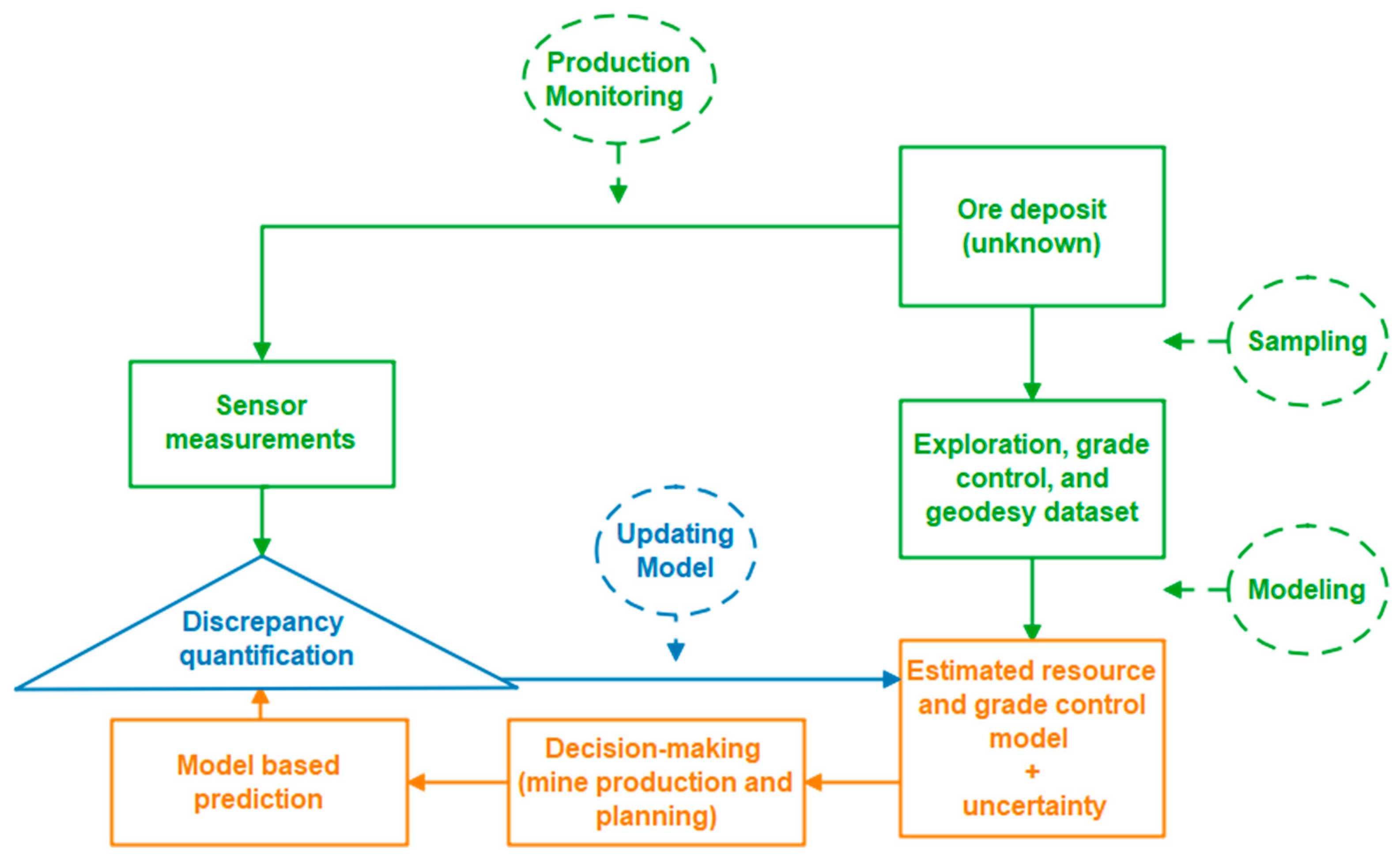
5. Data Assimilation in Closed-Loop RTM Management

The closed-loop concept in RTM involves continuously updating resource models by integrating real-time sensor measurements with predictive models, thus enhancing decision making and operational efficiency. Central to achieving this integration is the process of data assimilation, defined within the RTM framework as the recursive merging of new observations into the current resource model state. These observations may encompass additional spatial data types (spatial fusion) or arrive as sequential, time-stamped production updates, enabling the model to dynamically evolve and maintain accurate representations of the operational environment. Figure 4 presents a closed-loop workflow where sensor measurements from production monitoring are compared with model-based predictions to quantify discrepancies, thereby driving ongoing model updates. Data from exploration, geodesy, and grade control inform these models, accounting for ore deposit characteristics and the inherent uncertainties. Through continual iteration, sampling information and real-time sensor feedback align the estimated resource and grade control models with actual operational outcomes. The discrepancy quantification process ensures that any divergence from predictions is captured and integrated into subsequent model refinements. This adaptive feedback loop facilitates timely decision making for mine production and planning, ultimately optimizing operational strategies. By assimilating up-to-date information at each iteration, the system maintains robust, data-driven resource management.

5.1. Methods for Updating Data Assimilation in RTM Concept

Over the past decade, model-updating methodologies have advanced considerably, evolving from traditional linear Kalman filters to cutting-edge machine-learning approaches, such as reinforcement learning. This progression responds to the growing complexity and scale of RTM applications.
One of the most widely used techniques, the Kalman filter, offers a simple yet effective way to handle linear systems and parameter estimation. Its key limitation, however, lies in its reliance on linear dynamics and Gaussian assumptions, making it less suitable for capturing highly nonlinear relationships. Consequently, it performs best in scenarios where system updates are relatively moderate and largely linear in nature [16,91,92].
Another prevalent approach is the ensemble Kalman filter (EnKF), which accommodates moderate nonlinearities and sequential data assimilation better than the classic Kalman filter. Nevertheless, EnKF still depends on Gaussian assumptions, limiting its performance when variables deviate significantly from Gaussianity or when discontinuities are present. In complex or highly dynamic environments, hybridizing EnKF with other nonlinear methods can improve its robustness and assimilation accuracy [30,93,94].
Most recently, reinforcement learning has emerged as a particularly promising strategy for RTM, thanks to its ability to adapt to complex, high-dimensional datasets and rapidly changing mining conditions [32,95]. Although it demands extensive training data and robust computational resources, its capacity for real-time, adaptive decision making holds significant potential for optimizing operations in dynamic mining environments.
Moreover, other AI and machine-learning approaches, especially deep-learning models, such convolutional networks (e.g., 1-D, 2-D, 3-D CNNs) and recurrent networks (e.g., LSTM, GRU, Bidirectional LSTM, ConvLSTM (recurrent + convolutional)), as well as lightweight transformer encoders and transfer-learning pipelines, are now being deployed as learned surrogates within the red ‘data-assimilation’ loop (Figure 2); they ingest raw or minimally processed sensor streams, output probabilistic risk scores, and feed those to the EnKF or reinforcement learning policy, which then updates the dynamic resource state accordingly.
The diversity of data-assimilation approaches for RTM [31,32,96,97,98,99] illustrates a tension between simplicity and comprehensiveness. Although linear methods, such as the Kalman filter [16,92], have relatively low computational cost and can be easily implemented, they are typically effective only when the state-updating process remains close to linear. By contrast, EnKF-based approaches [30,93,100,101,102] and state of the art machine-learning methods, such as reinforcement learning [31,32], are better suited to severe nonlinearity and higher-dimensional problems. However, they demand significant computational resources and expertise. Thus, the all-important question is how much complexity (and, hence, computational overhead) can an RTM application withstand and still reach its project goals. Some practitioners exist on a spectrum of trade-offs: simpler algorithms are often adequate in relatively stable or mildly non-Gaussian conditions (more examples can be found in Table 4) while more complex hybrid and, most especially, reinforcement-learning-based methods are likely to become increasingly important for sharp dynamic, nonlinear, and high-dimensional mining challenges. The essential element for successful RTM is to find the sweet spot between computational tractability and accuracy within sense of the-RTM extent.
This methodological evolution is illustrated further in Table 4, as it begins with simple linear algorithms (Kalman filter) and works its way up to state-of-the-art machine-learning techniques (reinforcement learning). Simpler approaches perform well for linear or mildly non-Gaussian systems, whereas more complex algorithms are better suited to dynamic, high-dimensional, or nonlinear problems, albeit with increased computational cost. Therefore, selecting the most appropriate method typically involves balancing computational efficiency with the level of accuracy required for reliable decision making in RTM.

5.2. Applications of Updating Data Assimilation in RTM Concept

Several studies have demonstrated the potential of closed-loop data assimilation for RTM. For instance, Benndorf [16] introduced a closed-loop framework employing sequential resource model updating via the Kalman filter. By using synthetic data (representing a fully known environment), this approach showcased significant improvements in prediction accuracy whenever sensor-derived data were assimilated. The mean squared error (MSE) between estimated and actual block values served as the primary evaluation metric, showing substantial reductions in uncertainty, even in scenarios that involved multiple extraction sites and blending.
The updating approach uses the Kalman filter to estimate unknown state parameters recursively based on differences between predictions and observations. Let Z(x) represent a spatial random field with elements Z x i , where ⅈ = 1, …, n denotes the index of discrete extraction locations. The production matrix A describes the contribution of each mining block to the total production during a specific time interval. The relationship between the predicted resource model and sensor measurements can be expressed as (Equation (1)):
z t * = A z * x t
where z t * is the model-based prediction of extracted material for time intervals. Kalman filter updating can then be represented as (Equation (2)):
z * x t + 1 = z * x t + K y t A z * x t
where K is the Kalman gain matrix, determined by Equation (3):
K = C t , t A T A C t , t A T + C v , v 1
where C t , t represents the covariance of the prior model, while C v , v is the covariance of the measurement noise. The Kalman gain controls how much the observed differences (or innovations) between predicted and measured values influence the updated resource model. If the measurement noise is low and the prior model error is high, the Kalman gain increases, resulting in significant updates to the resource model.
Building upon this foundation, Yüksel, Thielemann, Wambeke and Benndorf [94] implemented a closed-loop concept for real-time resource model updating in the Garzweiler lignite mine, focusing on coal quality control. By continuously integrating online ash content measurements from the KOLA system into the model, they achieved up to a 70% reduction in model uncertainty. The EnKF gain determined the weight assigned to new sensor data versus the existing model, guiding the sequential updating process.
Extending this work, Yüksel, Benndorf, Lindig and Lohsträter [93] applied the closed-loop concept to a lignite mining case with multiple production benches. Online ash content measurements were taken using a radiometric sensor on the central conveyor belt, measuring blended material from multiple excavators. The forward simulation technique was used to associate sensor measurements with respective blocks, considering travel time from different excavators. Significant improvements were reported, with an average absolute error (AE) reduction of up to 73% using the updated model, where AE is defined as (Equation (4)):
A E = 1 n i = 0 n l i z * x i
where l i represents the sensor measurements and z * x i are the updated model values. Significant improvements were reported, with an average error reduction of up to 73% when using the updated model compared to the prior model.
Furthermore, the study compared two approaches for generating prior models: one based on geostatistical simulation using drill hole data and the other based on a simplified short-term model, which introduced fluctuations around the company’s mining plan. The simplified approach offered comparable improvements in model predictions, demonstrating the practicality of using a less computationally intensive method for RTM applications. By reducing the computational burden, the short-term model approach facilitated easier operational implementation without the need for complex geostatistical simulations.
Moreover, Wambeke and Benndorf [29] expanded the closed-loop concept through the development of geostatistical models for grade control reconciliation, utilizing the EnKF to handle the complexities involved in large-scale mining operations. They developed a sequential estimation method for updating the grade control (GC) model in real time based on new sensor observations. The algorithm is designed to integrate blended observations from multiple extraction points, making it particularly useful in mining environments where material streams are combined before measurements are taken.
The forward simulation step is crucial for estimating the contribution of individual blocks to blended material streams. This allows for linking each measurement back to its constituent blocks, despite blending from different extraction locations. Unlike previous methods, their forward simulator does not require an analytical formulation of the observation model, enhancing practicality in complex mining scenarios.
Subsequently, Wambeke and Benndorf [30] analyzed the influence of system parameters, such as measurement volume, blending ratios, and sensor precision on algorithm performance. Conducting 125 experiments, they explored how these factors affect the EnKF-based grade control model updating. The blending ratio defines the proportion of material in the blended measurement volume originating from different extraction zones, while the measurement volume represents the amount of material characterized by the sensor over a given time interval.
The updated GC model significantly improved the alignment of predicted versus actual production data. Specifically, the reduction in root-mean-square deviation (RMSE) between predicted and measured values was used to quantify improvements by Equation (5):
R M S E t = 1 N n = 1 N z * n E z t n 2
where z * n represents the true state, and E z t n is the expected value of the estimated block values at time t. By incorporating new sensor observations sequentially, the model progressively reduced uncertainty, resulting in improvements of up to 74% in some scenarios.
Lan, et al. [103] proposed a sequential ensemble-based optimal design (SEOD) method to enhance real-time parameter estimation in groundwater reactive transport models, which has direct parallels to closed-loop concepts in RTM. They employed the SEOD method in both one-dimensional and two-dimensional groundwater models to jointly estimate hydraulic conductivity and geochemical parameters. The results showed significant reductions in RMSE and ensemble spread, indicating the effectiveness of the method in reducing uncertainty and improving model predictions.
The SEOD method utilizes the EnKF to estimate both physical and geochemical parameters, continuously updating the system model based on optimal sensor data collection. This is similar to previous approaches in RTM, where sensor measurements and forward simulations are integrated to update resource models, aiming to reduce uncertainties in model predictions.
The closed-loop concept, as described in this study, involves an iterative process to refine the resource model in real time by assimilating sensor-based observations. The SEOD framework addresses some of the inherent challenges in such systems, including the optimization of sensor placement to maximize information gain, using the Kullback–Leibler divergence (also known as relative entropy, RE) as a metric for determining the value of information obtained from measurements.
Mathematically, the SEOD framework is implemented through the following stages.
  • Forecast Step: The EnKF-based SEOD begins with a forecast step, where the forward model G is used to propagate the current ensemble of state vectors x i , j a to the next time step (Equation (6)):
x i , j + 1 f = G x i , j a
where x f and x a represent the forecast and analysis states, respectively.
2.
Optimal Sampling Design: The SEOD framework aims to determine the optimal locations for collecting new measurements, which is achieved by maximizing the relative entropy (RE) between the previous and posterior distributions. For a Gaussian distribution, RE is given by Equation (7):
R E = J b + ln det B A 1 + Tr A B 1 n 2
where J b is the signal part of RE, and A and B are the covariance matrices of prior and posterior distributions, respectively. The optimal sampling locations are determined using a genetic algorithm (GA) by solving the following optimization problem (Equation (8)):
H o p t = arg max R E H
where H represents the candidate sampling strategy.
3.
Analysis Step: After determining the optimal sampling strategy, the analysis step is performed to assimilate the collected data and update the state vector by Equation (9):
x i , j a = x , j + 1 f + C Y D C D D + C D 1 ( d o b s d i )
where C Y D is the cross-covariance between forecast states and predicted data, C D D is the covariance of the predicted data, and C D represents the measurement error covariance.
The SEOD method, thus, represents a dynamic approach to integrating measurement data for the purpose of parameter estimation. This approach shares similarities with RTM practices where data assimilation techniques, such as EnKF, are used to refine geological models and optimize production processes. A critical difference, however, lies in the use of an optimal sampling strategy to enhance the quality of parameter estimation, leading to more efficient computational performance and better model accuracy compared to traditional methods.
Several studies addressed the limitations of the EnKF in handling non-Gaussian distributions and maintaining geological realism. Nejadi, et al. [104] incorporated the EnKF with probability field (P-Field) simulation to improve characterization of facies boundaries in reservoir models. Jafarpour and McLaughlin [101] combined the EnKF with the discrete cosine transform (DCT) parameterization to reduce dimensionality and preserve geological features. Hu, Zhao, Liu, Scheepens and Bouchard [100] applied a closed-loop concept by combining multipoint simulation (MPS) with the EnKF for real-time reservoir history matching, maintaining geological consistency in facies models. Oliver and Chen [105] discussed data assimilation in truncated plurigaussian (TPG) models, addressing non-monotonic relationships between latent variables and facies types.
For preserving non-Gaussian geological features, Kumar and Srinivasan [97] introduced indicator-based data assimilation (InDA), preserving non-Gaussian characteristics of geological models during assimilation. Ma and Jafarpour [98] integrated soft data into MPS simulation for facies model calibration, improving consistency with training images and observed data.
Zhou, et al. [106] transformed the original state vector into a univariate Gaussian using the normal-score EnKF (NS-EnKF), preserving non-Gaussian distributions in the updated models, crucial for maintaining geological realism. This method is particularly useful in RTM, where maintaining the complex spatial features of geological formations, such as channels or facies boundaries, is essential for accurate model updates. The closed-loop approach presented in this study demonstrates how transforming state variables into Gaussian space can improve data assimilation in non-Gaussian contexts, ultimately enhancing the quality of real-time geological models and reducing uncertainty in decision-making processes.
In smaller-scale grade heterogeneity studies, Li, Sepúlveda, Xu and Dowd [92] presented a rapid updating method to predict grade heterogeneity at smaller scales using a Kalman filter framework, integrating production data for near real-time resource model downscaling. The method improved mining selectivity and ore recoverability by accurately predicting grade heterogeneity within larger mining blocks. The advantages of the proposed method include its ability to integrate different types of sensed data without requiring complex co-kriging or simulation techniques, as well as its computational efficiency.
Prior, Benndorf and Mueller [102] proposed a closed-loop framework for updating resource and grade control models in underground mining, integrating sensor-based information using the EnKF. The approach improved prediction accuracy for ore grade and vein thickness, even with sparse initial conditioning information.
Previously, Tolosana-Delgado, van den Boogaart and Benndorf [33] introduced a closed-loop updating framework for compositional geometallurgical variables, employing log-ratio transformations and flow anamorphosis to handle compositional data in the EnKF while preserving their relationships.
Machine-learning approaches have also gained traction. Avalos, et al. [107] applied machine-learning and deep learning techniques in RTM to forecast energy consumption in semi-autogenous grinding mills. By leveraging recurrent neural networks to model temporal dependencies, they achieved significant improvements in prediction accuracy, enabling dynamic energy management and operational efficiency in real-time settings. Ortiz, et al. [108] highlighted the integration of geometallurgical data and process models within a RTM framework to optimize the mining value chain. By addressing uncertainties through stochastic modeling, the study demonstrated enhanced mine designs and operational strategies for improved economic and environmental outcomes.
Kumar and Dimitrakopoulos [32] proposed a novel approach to updating geostatistically simulated models of mineral deposits in real time using a reinforcement learning framework. They developed a self-learning algorithm based on the deep deterministic policy gradient (DDPG) reinforcement learning method, incorporating actor and critic agents. The purpose of this approach is to learn from incoming data collected during mining operations and to update the geostatistical models accordingly. This approach allows the model to account for high-order spatial statistics, enabling more accurate representation of the mineral deposits’ geological structure and grade distribution.
The proposed method applies reinforcement learning where the mining grid is sequentially visited in a random path. The environment provides the state for each grid node, which includes the properties of blocks, sensor data, conditioning data events, and other contextual information. The actor agent takes actions that predict updated properties for the grid nodes, and these predictions are evaluated by the critic agent. This setup allows for a dynamic model that learns and adjusts based on new incoming information.
Mathematically, the reward at each step is calculated to ensure that the updated properties align with both high-order spatial statistics and the incoming temporal sensor data. The actor–critic system is designed such that the state at time step is updated by incorporating new sensor data and conditioning events to maximize the reward function, which includes terms for spatial and temporal consistency.
Talesh Hosseini, Asghari, Benndorf and Emery [99] integrated the discrete wavelet transform (DWT) with the EnKF to update and improve geological boundary definitions at the Golgohar Iron Ore Mine, significantly increasing boundary accuracy while maintaining consistency with production data.
Finally, de Carvalho and Dimitrakopoulos [31] presented an actor–critic reinforcement learning approach for short-term production planning and fleet management in mining complexes. By defining shovel and truck allocation policies adaptively, the model addressed operational constraints and uncertainties dynamically, resulting in a 47% improvement in cash flow compared to traditional fixed fleet assignments. The continuous update of orebody models based on sensor-collected data further emphasized the practical advantages of integrating RL for adaptive decision making. The performance of these studies are shown in Table 5.
These studies demonstrate significant advancements in data assimilation methods within closed-loop RTM management. The integration of Kalman filters and their variants with innovative techniques, such as DCT, MPS, and reinforcement learning approaches, has led to improved prediction accuracy, reduced uncertainty, and maintained geological realism. The table summarizes these advancements, highlighting the methods employed, case studies undertaken, and the results achieved. Collectively, these works emphasize the practical effectiveness of continuous model updating in modern mining practices, underscoring its value in enhancing operational decision making and efficiency across diverse mining environments.

6. Bridging RTM Implementation Gaps with Advanced Data Analytics

Much progress has been made over the past decade; however, fully integrated RTM concepts remain largely unimplemented in practical, real-world settings. A key tool for assessing the maturity of RTM approaches is the technology readiness level (TRL) framework. Originally developed by NASA, the TRL framework is a metric that ranges from TRL 1, where basic principles are observed, to TRL 9, where systems are fully operational. The framework has been adopted by the European Union and many industries to evaluate innovation across a wide range of sectors, linking technological development to funding and implementation milestones [109,110,111]. When applied to RTM components, this framework reveals a large gap between research and its practical application, demonstrating the need for strategic pathways to move these technologies toward higher TRLs.
In the context of RTM, the maturity levels of key components are as follows: the real system, comprising physical mining activities, such as drilling, hauling, and processing, stands at TRL 7, reflecting successful prototype demonstration in operational environments but still requiring fully integrated automation and data workflows. Production monitoring, which involves advanced sensor networks that measure ore grades and equipment performance, is at TRL 8, with systems routinely deployed and thoroughly tested, though consistent data standardization remains a challenge. By contrast, system models (e.g., digital twins and resource models) currently reach only TRL 5, as they have been validated in relevant mining environments but are not yet fully operational on a large scale. This is primarily due to the fact that many mines operate with incomplete or inconsistent databases. Optimization algorithms, providing real-time decision support, stay at TRL 4, with most testing confined to laboratory or pilot-scale settings and lacking robust deployment in live production due to the need for specialized data scientists and IT infrastructure on site. Data assimilation, which updates system models in near real time by blending sensor data and historical records, reaches TRL 6, having been demonstrated in pilot environments but not widely adopted for continuous industrial use. Taken together, these elements form an overall RTM system whose readiness is estimated at around TRL 6, owing primarily to challenges such as a lack of consistent geodata infrastructure, limited availability of geo data scientists in operations, and interoperability complexities that inhibit seamless integration across sensors, models, and algorithms (see Figure 5). Overcoming these hurdles through standardized data protocols, expanded on-site analytics, and interdisciplinary collaboration is essential for reaching TRL 8–9 and achieving a fully operational, field-proven RTM system.
Although key constituents of RTM, ranging from online sensors and data-assimilation schemes to optimization engines and digital-twin platforms, have advanced markedly in laboratory and pilot studies, their collective deployment is still feasible only in narrowly defined scenarios, such as lignite strip mines with continuous conveyor haulage and in highly selective underground operations (e.g., cut-and-fill or sub-level stoping), that already possess ore-tracking infrastructure and relatively homogeneous mineralogy.
RTM adds value when three factors align, namely when the orebody shows meaningful short-range grade variability, the operation uses a continuous shovel–crusher–belt chain in an open pit or a selective, short-cycle underground stoping method, and rugged online sensors feed time-stamped data into haulage and plant databases for rapid model updates [94,102]. If variability is low or digital infrastructure is limited, as in block caving or room-and-pillar coal, RTM offers little economic benefit.
RTM in underground mines is aimed at tactical, short-range optimizations within the existing stoping plan, such as trimming stope boundaries, real-time muck routing and on-belt blend control, rather than wholesale changes to equipment or mining method. These adjustments occur inside the normal drill–blast–haul cycle and therefore do not require costly redesigns or resequencing of developments.
Most conveyor-mounted PGNAA/LIBS grade sensors have demonstrated reliable operation at TRL 8, whereas multimodal face-imaging and LiDAR-fusion units that must survive blasting cycles remain at TRL 5 to 6. Early pilots, most notably the Garzweiler lignite mine (about 70% reduction in block-model uncertainty) on surface [94] and the Reiche-Zeche vein mine (sequential grade-model updating during cut-and-fill) underground [102], confirm the technical soundness of the approach but also highlight four inter-dependent constraints that still block routine adoption: (i) ruggedized, multimodal sensors with verified calibrations across moisture, dust and vibration regimes; (ii) high-fidelity, time-stamped material-tracking systems absent from many legacy mines; (iii) AI-driven optimization engines that require dense labelled data streams and on-site computing rarely available outside flagship demonstrations; and (iv) persistent interoperability gaps among geological databases, process-control historians and enterprise-resource-planning platforms. Until standardized data backbones, edge-to-cloud analytics pipelines and cross-disciplinary human expertise are co-developed at scale, RTM will remain confined to operations whose geological simplicity and digital maturity can tolerate the present limitations, so tackling these systemic hurdles, rather than isolated sensor or algorithm refinements, must be central to any realistic roadmap for closing the RTM implementation gap.
To advance RTM components toward higher TRLs, strategic collaboration and targeted innovations are paramount. Advanced data analytics and AI are particularly indispensable in enhancing the adaptability, scalability, and operational efficiency of RTM. One foundational requirement involves the development of robust, field-ready sensors capable of withstanding the challenging conditions inherent to mining environments. Partnering with sensor manufacturers can accelerate this process. Moreover, leveraging machine learning, especially reinforcement learning, can bolster predictive capabilities while enabling real-time operational adjustments. These improvements are further supported by digital twins, which dynamically simulate and optimize mining processes.
Integrating AI into optimization algorithms offers real-time decision support by rapidly analyzing and assimilating large volumes of sensor data. Such integration not only expedites technological development but also ensures operational reliability through proactive equipment failure prevention and efficiency optimization. However, these gains hinge on establishing comprehensive material tracking systems and maintaining consistent geodatabases. The absence of such infrastructure, coupled with a lack of on-site geodata specialists, poses a significant bottleneck to effective RTM implementation.
Moving forward, RTM methodologies stand to benefit from hybrid models that merge AI with geostatistical techniques, thereby increasing both adaptability and precision. Advanced computational platforms, including cloud computing and parallel processing, can alleviate current computational bottlenecks. Additionally, the inclusion of diverse data sources, such as soft data and advanced sensor networks, promises to enhance model resolution and accuracy. By harnessing these advancements, RTM can solidify its role as a cornerstone of intelligent mining practices, driving efficient, adaptive, and data-driven resource management.
Advancing key constituents of the RTM approach requires coordinated efforts among researchers, technology developers, and industry stakeholders. Establishing pilot projects and field demonstrations will showcase practical benefits and return on investment, encouraging adoption. Economic incentives and funding mechanisms can offset initial costs, while standardizing protocols ensures compatibility and ease of integration. By leveraging advanced data analytics and AI, the mining industry can bridge the implementation gaps in RTM, advancing key components to higher TRLs. This progression will transform RTM from a theoretical concept into a practical, efficient, and sustainable operational system, effectively addressing the mineral resource dilemma and meeting global demands.

7. Conclusions

Real-time mining (RTM) now stands at the threshold between proof-of-concept pilots and routine industrial deployment; most subsystems have been validated only to about technology readiness levels (TRLs) 5–6. The remaining practical gaps include ruggedized multimodal sensors, interoperable data backbones, and on-site analytics talent able to convert torrents of geo-environmental data into second-by-second decisions. Closing these gaps demands an explicitly interdisciplinary alliance in which geoscientists, mineral-processing engineers, computer scientists, and social researchers co-design solutions so that grade-control algorithms mesh smoothly with drill-and-blast schedules, labor-safety dashboards, and community air-quality monitors. This holistic integration reframes RTM as more than a productivity tool; it becomes a platform for broad socio-economic benefit, delivering higher resource efficiency, lower energy intensity, transparent supply chains, and an enhanced social license that protects jobs in mining-dependent regions while moderating ecological footprints.
To lift RTM to TRL 8–9, we call for a coordinated policy–industry research agenda. Regulators can accelerate progress by mandating open data standards, embedding near-real-time environmental reporting in permitting schemes, and underwriting demonstration mines that de-risk early adoption. Mining companies should organize pre-competitive consortia with sensor manufacturers, artificial intelligence (AI) providers, recycling firms, and local communities to pilot end-to-end digital value chains and share lessons learned. Immediate research priorities are physics-informed machine learning that fuses sparse geological, geotechnical, and socio-environmental streams; resilient edge–cloud architectures that guarantee sub-second feedback despite harsh connectivity constraints; circular-economy metrics that couple RTM outputs with full life-cycle assessments; and governance models that protect data sovereignty while distributing productivity gains equitably. Progress on these fronts will close current readiness gaps and position RTM as a pivotal lever for meeting the European Critical Raw Materials Act, global net-zero goals, and the United Nations Sustainable Development Goals.

Author Contributions

Conceptualization, K.A. and J.B.; Methodology, K.A. and J.B.; Validation, K.A. and J.B.; Formal Analysis, K.A. and J.B.; Investigation, K.A.; Resources, J.B.; Data Curation, K.A.; Writing—Original Draft Preparation, K.A.; Writing—Review and Editing, K.A. and J.B.; Visualization, K.A.; Supervision, J.B.; Project Administration, J.B. All authors have read and agreed to the published version of the manuscript.

Funding

This research was funded by the Saxonian State Scholarship Program (Sächsische Landessti-pendienverordnung, SächsLStipVO), awarded by the Rectorate Commission “Graduiertenförder-ung” at the Technical University Bergakademie Freiberg.

Data Availability Statement

This review article does not involve the generation of new datasets. All data discussed and referenced are derived from previously published sources, which are appropriately cited throughout the paper.

Conflicts of Interest

The authors declare no conflicts of interest.

Abbreviations

The following abbreviations are used in this manuscript:
AEAbsolute Error
AIArtificial Intelligence
CLRMClosed-Loop Mineral Resource Management
DCTDiscrete Cosine Transform
DE-XRTDual Energy X-Ray Transmission
DTsDigital twins
DDPGDeep Deterministic Policy Gradient
EnKFEnsemble Kalman Filter
GAGenetic Algorithm
GCGrade Control
InDAIndicator-Based Data Assimilation
IoTInternet of Things
LIBSLaser-Induced Breakdown Spectroscopy
LiDARLight Detection and Ranging
LWIRLong-Wave Infrared
M2MMine-to-Mill
MWDMeasurement While Drilling
MWIRMid-Wave Infrared
NS-EnKFNormal-Score Ensemble Kalman Filter
NPVNet Present Value
OPSOpen-Pit Production Schedule
P-FieldProbability Field (in EnKF/P-Field simulation)
PGNAAPrompt Gamma Neutron Activation Analysis
PSOParticle Swarm Optimization
KPIsKey Performance Indicators
RLReinforcement Learning
RMSERoot-Mean-Square Error
RTMReal-Time Mining
SEODSequential Ensemble-Based Optimal Design
SWIRShort-Wave Infrared
TPGTruncated Plurigaussian
TRLTechnology Readiness Level
VNIRVisible-Near Infrared
WAIWide Area Illumination

References

  1. Watari, T.; Nansai, K.; Nakajima, K. Major metals demand, supply, and environmental impacts to 2100: A critical review. Resour. Conserv. Recycl. 2021, 164, 105107. [Google Scholar] [CrossRef]
  2. ICA. Copper—The Pathway to Net Zero; International Copper Association: Washington, DC, USA, 2023; p. 41. [Google Scholar]
  3. Pickens, N.; Joannides, E.; Laul, B. Red Metal, Green Demand—Copper’s Critical Role in Achieving Net Zero; Wood Mackenzie: Edinburgh, UK, 2022. [Google Scholar]
  4. Franken, G.; Schütte, P. Current trends in addressing environmental and social risks in mining and mineral supply chains by regulatory and voluntary approaches. Miner. Econ. 2022, 35, 653–671. [Google Scholar] [CrossRef]
  5. Yu, H.; Zahidi, I.; Fai, C.M.; Liang, D.; Madsen, D.Ø. Elevating community well-being in mining areas: The proposal of the mining area sustainability index (MASI). Environ. Sci. Eur. 2024, 36, 71. [Google Scholar] [CrossRef]
  6. Benndorf, J. Closed Loop Management in Mineral Resource Extraction: Turning Online Geo-Data into Mining Intelligence; Springer Nature: Cham, Switzerland, 2020. [Google Scholar]
  7. Anvari, K.; Mousavi, A.; Sayadi, A.R.; Sellers, E.; Salmi, E.F. Automatic detection of rock boundaries using a hybrid recurrence quantification analysis and machine learning techniques. Bull. Eng. Geol. Environ. 2022, 81, 398. [Google Scholar] [CrossRef]
  8. Masoumi, I.; Kamali, G.; Asghari, O.; Emery, X. Assessing the impact of geologic contact dilution in ore/waste classification in the Gol-Gohar Iron Ore Mine, Southeastern Iran. Minerals 2020, 10, 336. [Google Scholar] [CrossRef]
  9. Aghahadi, M.H.; Jozanikohan, G.; Asghari, O.; Hosseini, S.T.; Emery, X.; Rezaei, M. Geochemical anomaly separation based on geology, geostatistics, compositional data and local singularity analyses: A case study from the Kuh Panj copper deposit, Iran. Appl. Geochem. 2024, 173, 106135. [Google Scholar] [CrossRef]
  10. Matthäus, A.; Graham, P.; Soares, A. Real-Time Optimization of Extraction and the Logistic Process in Highly Complex Geological and Selective Mining Settings; European Commission: Brussels, Belgium, 2017. [Google Scholar]
  11. Kumar, A. Artificial Intelligence Algorithms for Real-Time Production Planning with Incoming New Information in Mining Complexes; McGill University: Montreal, Canada, 2020. [Google Scholar]
  12. Blom, M.; Pearce, A.R.; Stuckey, P.J. Short-term planning for open pit mines: A review. Int. J. Min. Reclam. Environ. 2019, 33, 318–339. [Google Scholar] [CrossRef]
  13. Dominy, S.C.; Noppé, M.A.; Annels, A.E. Errors and uncertainty in mineral resource and ore reserve estimation: The importance of getting it right. Explor. Min. Geol. 2002, 11, 77–98. [Google Scholar] [CrossRef]
  14. Lindi, O.T.; Aladejare, A.E.; Ozoji, T.M.; Ranta, J.-P. Uncertainty Quantification in Mineral Resource Estimation. Nat. Resour. Res. 2024, 33, 2503–2526. [Google Scholar] [CrossRef]
  15. Ullah, G.W.; Nehring, M.; Kizil, M.; Knights, P. Environmental, Social, and Governance Considerations in Production Scheduling Optimisation for Sublevel Stoping Mining Operations: A Review of Relevant Works and Future Directions. Min. Metall. Explor. 2023, 40, 2167–2182. [Google Scholar] [CrossRef]
  16. Benndorf, J. Making use of online production data: Sequential updating of mineral resource models. Math. Geosci. 2015, 47, 547–563. [Google Scholar] [CrossRef]
  17. Sánchez, F.; Hartlieb, P. Innovation in the mining industry: Technological trends and a case study of the challenges of disruptive innovation. Min. Metall. Explor. 2020, 37, 1385–1399. [Google Scholar] [CrossRef]
  18. Young, A.; Rogers, P. A review of digital transformation in mining. Min. Metall. Explor. 2019, 36, 683–699. [Google Scholar] [CrossRef]
  19. Aznar-Sánchez, J.A.; Velasco-Muñoz, J.F.; Belmonte-Ureña, L.J.; Manzano-Agugliaro, F. Innovation and technology for sustainable mining activity: A worldwide research assessment. J. Clean. Prod. 2019, 221, 38–54. [Google Scholar] [CrossRef]
  20. Buxton, M.; Benndorf, J. The use of sensor derived data in optimization along the Mine-Value-Chain. In Proceedings of the 15th International ISM Congress, Aachen, Germany, 16–20 September 2013; pp. 324–336. [Google Scholar]
  21. Desta, F. Sensing and Data Fusion Opportunities for Raw Material Characterisation in Mining: Technology and Data-Driven Approach. Ph.D. Thesis, Delft University of Technology, Delft, The Netherlands, 2021. [Google Scholar]
  22. Lessard, J.; de Bakker, J.; McHugh, L. Development of ore sorting and its impact on mineral processing economics. Miner. Eng. 2014, 65, 88–97. [Google Scholar] [CrossRef]
  23. Corrigan, C.C.; Ikonnikova, S.A. A review of the use of AI in the mining industry: Insights and ethical considerations for multi-objective optimization. Extr. Ind. Soc. 2024, 17, 101440. [Google Scholar] [CrossRef]
  24. Jackson, J. Enabling Short Interval Control Using Spatial Dense Geoscience Info Beyond Grade. 2020. Available online: https://smi.uq.edu.au/event/session/6543 (accessed on 18 November 2024).
  25. Anvari, K.; Mousavi, A.; Sayadi, A.R.; Afzal, P.; Sellers, E.; Salmi, E.F. A Hybrid Recurrence Analysis and Wavelet Transformation for Rock Boundary Identification. Preprint 2024. Preprint 2024. [Google Scholar] [CrossRef]
  26. Aghahadi, M.H.; Jozanikohan, G.; Asghari, O.; Anvari, K.; Hosseini, S.T. Spatial Clustering of Primary Geochemical Halos Using Unsupervised Machine Learning in Sari Gunay Gold Deposit, Iran. Min. Metall. Explor. 2024, 41, 2741–2760. [Google Scholar] [CrossRef]
  27. Dalm, M. Sensor-Based Sorting Opportunities for Hydrothermal Ore Deposits: Raw Material Beneficiation in Mining. Ph.D. Thesis, Delft University of Technology, Delft, The Netherlands, 2018. [Google Scholar]
  28. Guatame-Garcia, A.; Buxton, M. Framework for monitoring and control of the production of calcined kaolin. Minerals 2020, 10, 403. [Google Scholar] [CrossRef]
  29. Wambeke, T.; Benndorf, J. A simulation-based geostatistical approach to real-time reconciliation of the grade control model. Math. Geosci. 2017, 49, 1–37. [Google Scholar] [CrossRef]
  30. Wambeke, T.; Benndorf, J. A study of the influence of measurement volume, blending ratios and sensor precision on real-time reconciliation of grade control models. Math. Geosci. 2018, 50, 801–826. [Google Scholar] [CrossRef] [PubMed]
  31. de Carvalho, J.P.; Dimitrakopoulos, R. Integrating short-term stochastic production planning updating with mining fleet management in industrial mining complexes: An actor-critic reinforcement learning approach. Appl. Intell. 2023, 53, 23179–23202. [Google Scholar] [CrossRef]
  32. Kumar, A.; Dimitrakopoulos, R. Updating geostatistically simulated models of mineral deposits in real-time with incoming new information using actor-critic reinforcement learning. Comput. Geosci. 2022, 158, 104962. [Google Scholar] [CrossRef]
  33. Prior, Á.; Tolosana-Delgado, R.; van den Boogaart, K.G.; Benndorf, J. Resource model updating for compositional geometallurgical variables. Math. Geosci. 2021, 53, 945–968. [Google Scholar] [CrossRef]
  34. Bisschoff, R.; Grobbelaar, S. Evaluation of data-driven decision-making implementation in the mining industry. S. Afr. J. Ind. Eng. 2022, 33, 218–232. [Google Scholar] [CrossRef]
  35. Jansen, J.-D.; Douma, S.; Brouwer, D.R.; Van den Hof, P.; Bosgra, O.; Heemink, A. Closed-loop reservoir management. In Proceedings of the SPE Reservoir Simulation Conference, The Woodlands, TX, USA, 2–4 February 2009. SPE–119098-MS. [Google Scholar]
  36. Babaei Khorzoughi, M.; Hall, R.; Apel, D. Rock fracture density characterization using measurement while drilling (MWD) techniques. Int. J. Min. Sci. Technol. 2018, 28, 859–864. [Google Scholar] [CrossRef]
  37. Babaei Khorzoughi, M.; Hall, R. Processing of measurement while drilling data for rock mass characterization. Int. J. Min. Sci. Technol. 2016, 26, 989–994. [Google Scholar] [CrossRef]
  38. Sellers, E.J.; Salmi, E.F.; Usami, K.; Greyvensteyn, I.; Mousavi, A. Detailed Rock Mass Characterization—A Prerequisite for Successful Differential Blast Design. In Proceedings of the YSRM2019—The 5th ISRM Young Scholars’ Symposium on Rock Mechanics and REIF2019—International Symposium on Rock Engineering for Innovative Future—An ISRM Specialized Conference, Okinawa, Japan, 1–4 December 2019. [Google Scholar]
  39. Usami, K.; Salmi, E.F.; Sellers, E.J. Genetic Algorithm to Optimise Rock Fragmentation in Selective Blasting for Grade Engineering. In Proceedings of the 26th International Mining Congress and Exhibition of Turkey, Belek, Antalya, Turkey, 16–19 April 2019; pp. 359–372. [Google Scholar]
  40. McKee, D. Understanding Mine to Mill; The Cooperative Research Centre for Optimising Resource Extraction: Brisbane, Australia, 2013; Volume 96, p. 2013. [Google Scholar]
  41. Salmi, E.; Mousavi, A.; Usami, K.; Sellers, E. Value chain optimization for grade engineering by mine-wide frag-mentation optimisation. In Rock Fragmentation by Blasting; Wang, X.G., Ed.; CRC Press: London, UK, 2022. [Google Scholar]
  42. Salmi, E.F.; Sellers, E.J. A review of the methods to incorporate the geological and geotechnical characteristics of rock masses in blastability assessments for selective blast design. Eng. Geol. 2021, 281, 105970. [Google Scholar] [CrossRef]
  43. Kurth, H. Measuring ore quality using real-time on-belt elemental analysis—More than grade control. In Proceedings of the International Mining Geology Conference, Hobart, Australia, 20–22 September 2017; pp. 20–22. [Google Scholar]
  44. Charbucinski, J.; Malos, J.; Rojc, A.; Smith, C. Prompt gamma neutron activation analysis method and instrumentation for copper grade estimation in large diameter blast holes. Appl. Radiat. Isot. 2003, 59, 197–203. [Google Scholar] [CrossRef]
  45. Clarkson, L.; Williams, D. Critical review of tailings dam monitoring best practice. Int. J. Min. Reclam. Environ. 2020, 34, 119–148. [Google Scholar] [CrossRef]
  46. Jawhari, T.; Roid, A.; Casado, J. Raman spectroscopic characterization of some commercially available carbon black materials. Carbon 1995, 33, 1561–1565. [Google Scholar] [CrossRef]
  47. Lintvedt, T.A.; Andersen, P.V.; Afseth, N.K.; Wold, J.P. In-line Raman spectroscopy for characterization of an industrial poultry raw material stream. Talanta 2024, 266, 125079. [Google Scholar] [CrossRef] [PubMed]
  48. Dalm, M.; Sandtke, M. Geochemical mapping of drill core samples using a combined LIBS and XRF core scanning system. In Proceedings of the Real-Time Mining Conference, Freiberg, Germany, 26–27 March 2019; pp. 26–27. [Google Scholar]
  49. Lawley, C.J.; Somers, A.M.; Kjarsgaard, B.A. Rapid geochemical imaging of rocks and minerals with handheld laser induced breakdown spectroscopy (LIBS). J. Geochem. Explor. 2021, 222, 106694. [Google Scholar] [CrossRef]
  50. Díaz Pace, D.M.; Gabriele, N.A.; Garcimuño, M.; D’Angelo, C.A.; Bertuccelli, G.; Bertuccelli, D. Analysis of minerals and rocks by laser-induced breakdown spectroscopy. Spectrosc. Lett. 2011, 44, 399–411. [Google Scholar] [CrossRef]
  51. Guo, L.-B.; Zhang, D.; Sun, L.-X.; Yao, S.-C.; Zhang, L.; Wang, Z.-Z.; Wang, Q.-Q.; Ding, H.-B.; Lu, Y.; Hou, Z.-Y. Development in the application of laser-induced breakdown spectroscopy in recent years: A review. Front. Phys. 2021, 16, 22500. [Google Scholar] [CrossRef]
  52. Palleschi, V. Laser-induced breakdown spectroscopy: Principles of the technique and future trends. ChemTexts 2020, 6, 18. [Google Scholar] [CrossRef]
  53. Benndorf, J.; Restrepo, D.A.; Merkel, N.; John, A.; Buxton, M.; Guatame-Garcia, A.; Dalm, M.; de Waard, B.; Flores, H.; Möllerherm, S. TRIM4Post-Mining: Transition Information Modelling for Attractive Post-Mining Landscapes—A Conceptual Framework. Mining 2022, 2, 248–277. [Google Scholar] [CrossRef]
  54. Andreas Gunke, S.J. Derivation of Mine from correlates ALS, TLS and RGB Data. In 19. Geokinematischer TU Bergakademie Freiberg; Department of Mine Surveying and Geodesy: Freiberg, Germany, 2018; pp. 79–86. [Google Scholar]
  55. Jiang, C.; Chen, Y.; Tian, W.; Feng, Z.; Li, W.; Zhou, C.; Shao, H.; Puttonen, E.; Hyyppä, J. A practical method utilizing multi-spectral LiDAR to aid points cloud matching in SLAM. Satell. Navig. 2020, 1, 29. [Google Scholar] [CrossRef]
  56. Martienßen, T.; Geier, A.; Wand, R. Untersuchungen Zur Entfernungsmessung Terrestrischer Long-Range Laserscanner; Technische Universitaet Bergakademie Freiberg Universitaetsbibliothek “Georgius Agricola”: Freiberg, Germany, 2016. [Google Scholar]
  57. Donner, R.; Rabel, M.; Scholl, I.; Ferrein, A.; Donner, M.; Geier, A.; John, A.; Köhler, C.; Varga, S. Die Extraktion Bergbaulich Relevanter Merkmale Aus 3d-Punktwolken Eines Untertagetauglichen Mobilen Multisensorsystems; Institutionelles Repositorium der Leibniz Universität Hannover: Hannover, Germany, 2019. [Google Scholar]
  58. Köhler, C.; Donner, M.; Donner, R. Semantische Klassifizierung von 3D-Punktwolken; TU Bergakademie Freiberg: Freiberg, Germany, 2018. [Google Scholar]
  59. Chen, Y.; Jiang, C.; Hyyppä, J.; Qiu, S.; Wang, Z.; Tian, M.; Li, W.; Puttonen, E.; Zhou, H.; Feng, Z. Feasibility study of ore classification using active hyperspectral LiDAR. IEEE Geosci. Remote Sens. Lett. 2018, 15, 1785–1789. [Google Scholar] [CrossRef]
  60. Naseri, A.; Rezaei Nasab, A. Automatic identification of minerals in thin sections using image processing. J. Ambient Intell. Humaniz. Comput. 2023, 14, 3369–3381. [Google Scholar] [CrossRef]
  61. Desta, F.; Buxton, M. Evaluation of sensor technologies for on-line raw material characterization in “Reiche Zeche” underground mine-outcomes of RTM implementation. In Proceedings of the 2019 REAL TIME MINING-Conference on Innovation on Raw Material Extraction, Freiberg, Germany, 26–27 March 2019; pp. 32–47. [Google Scholar]
  62. Riley, D.N.; Hecker, C.A. Mineral mapping with airborne hyperspectral thermal infrared remote sensing at Cuprite, Nevada, USA. In Thermal Infrared Remote Sensing: Sensors, Methods, Applications; Springer: Dordrecht, The Netherlands, 2013; pp. 495–514. [Google Scholar]
  63. Prabhavathy, P.; Tripathy, B.; Venkatesan, M. Unsupervised learning method for mineral identification from hyperspectral data. In Innovations in Bio-Inspired Computing and Applications, Proceedings of the 10th International Conference on Innovations in Bio-Inspired Computing and Applications (IBICA 2019), Gunupur, Odisha, India, 16–18 December 2019; Springer: Cham, Switzerland, 2021; Volume 10, pp. 148–160. [Google Scholar]
  64. Neubert, K.; Wotruba, H. Investigations on the detectability of rare-earth minerals using dual-energy X-ray transmission sorting. J. Sustain. Metall. 2017, 3, 3–12. [Google Scholar] [CrossRef]
  65. Noriega, R.; Pourrahimian, Y. A systematic review of artificial intelligence and data-driven approaches in strategic open-pit mine planning. Resour. Policy 2022, 77, 102727. [Google Scholar] [CrossRef]
  66. Whittle, D. Open-pit planning and design. In SME Mining Engineering Handbook; Society for Mining, Metallurgy, and Exploration: Englewood, NJ, USA, 2011; Volume 1, pp. 877–901. [Google Scholar]
  67. Askari-Nasab, H.; Frimpong, S.; Szymanski, J. Modelling open pit dynamics using discrete simulation. Int. J. Min. Reclam. Environ. 2007, 21, 35–49. [Google Scholar] [CrossRef]
  68. Albor Consuegra, F.; Dimitrakopoulos, R. Stochastic mine design optimisation based on simulated annealing: Pit limits, production schedules, multiple orebody scenarios and sensitivity analysis. Min. Technol. 2009, 118, 79–90. [Google Scholar] [CrossRef]
  69. Moosavi, E.; Gholamnejad, J.; Ataee-Pour, M.; Khorram, E. A hybrid augmented Lagrangian multiplier method for the open pit mines long-term production scheduling problem optimization. J. Min. Sci. 2014, 50, 1047–1060. [Google Scholar] [CrossRef]
  70. Both, C.; Dimitrakopoulos, R. Joint stochastic short-term production scheduling and fleet management optimization for mining complexes. Optim. Eng. 2020, 21, 1717–1743. [Google Scholar] [CrossRef]
  71. Mousavi, A.; Kozan, E.; Liu, S.Q. Comparative analysis of three metaheuristics for short-term open pit block sequencing. J. Heuristics 2016, 22, 301–329. [Google Scholar] [CrossRef]
  72. Mousavi, A.; Kozan, E.; Liu, S.Q. Open-pit block sequencing optimization: A mathematical model and solution technique. Eng. Optim. 2016, 48, 1932–1950. [Google Scholar] [CrossRef]
  73. Goodfellow, R.; Dimitrakopoulos, R. Simultaneous stochastic optimization of mining complexes and mineral value chains. Math. Geosci. 2017, 49, 341–360. [Google Scholar] [CrossRef]
  74. Lamghari, A.; Dimitrakopoulos, R.; Ferland, J.A. A hybrid method based on linear programming and variable neighborhood descent for scheduling production in open-pit mines. J. Glob. Optim. 2015, 63, 555–582. [Google Scholar] [CrossRef]
  75. Nobahar, P.; Xu, C.; Dowd, P.; Faradonbeh, R.S. Exploring digital twin systems in mining operations: A review. Green Smart Min. Eng. 2024, 1, 474–492. [Google Scholar] [CrossRef]
  76. Saldana, M.; Gallegos, S.; Arias, D.; Salazar, I.; Castillo, J.; Salinas-Rodríguez, E.; Navarra, A.; Toro, N.; Cisternas, L.A. Applications of Kuz–Ram Models in Mine-to-Mill Integration and Optimization—A Review. Minerals 2024, 14, 1162. [Google Scholar] [CrossRef]
  77. Guyaguler, B.; Horne, R.N.; Rogers, L.; Rosenzweig, J.J. Optimization of well placement in a Gulf of Mexico waterflooding project. SPE Reserv. Eval. Eng. 2002, 5, 229–236. [Google Scholar] [CrossRef]
  78. Yeten, B.; Durlofsky, L.J.; Aziz, K. Optimization of nonconventional well type, location, and trajectory. SPE J. 2003, 8, 200–210. [Google Scholar] [CrossRef]
  79. Levinson, Z.; Dimitrakopoulos, R.; Keutchayan, J. Simultaneous stochastic optimization of an open-pit mining complex with preconcentration using reinforcement learning. Appl. Soft Comput. 2023, 138, 110180. [Google Scholar] [CrossRef]
  80. Noriega, R.; Boisvert, J. Optimization of underground mining production layouts considering geological uncertainty using deep reinforcement learning. Eng. Appl. Artif. Intell. 2025, 139, 109493. [Google Scholar] [CrossRef]
  81. Noriega, R.; Pourrahimian, Y.; Askari-Nasab, H. Deep Reinforcement Learning based real-time open-pit mining truck dispatching system. Comput. Oper. Res. 2025, 173, 106815. [Google Scholar] [CrossRef]
  82. Pendharkar, P.C.; Rodger, J.A. Nonlinear programming and genetic search application for production scheduling in coal mines. Ann. Oper. Res. 2000, 95, 251–267. [Google Scholar] [CrossRef]
  83. Leite, A.; Dimitrakopoulos, R. Stochastic optimisation model for open pit mine planning: Application and risk analysis at copper deposit. Min. Technol. 2007, 116, 109–118. [Google Scholar] [CrossRef]
  84. Sayadi, A.R.; Fathianpour, N.; Mousavi, A.A. Open pit optimization in 3D using a new artificial neural network. Arch. Min. Sci. 2011, 56, 389–403. [Google Scholar]
  85. Souza, M.J.; Coelho, I.M.; Ribas, S.; Santos, H.G.; Merschmann, L.H.d.C. A hybrid heuristic algorithm for the open-pit-mining operational planning problem. Eur. J. Oper. Res. 2010, 207, 1041–1051. [Google Scholar] [CrossRef]
  86. Shishvan, M.S.; Benndorf, J. Simulation-based optimization approach for material dispatching in continuous mining systems. Eur. J. Oper. Res. 2019, 275, 1108–1125. [Google Scholar] [CrossRef]
  87. Lamghari, A.; Dimitrakopoulos, R. Hyper-heuristic approaches for strategic mine planning under uncertainty. Comput. Oper. Res. 2020, 115, 104590. [Google Scholar] [CrossRef]
  88. LaRoche-Boisvert, M.; Dimitrakopoulos, R. An application of simultaneous stochastic optimization at a large open-pit gold mining complex under supply uncertainty. Minerals 2021, 11, 172. [Google Scholar] [CrossRef]
  89. Levinson, Z.; Dimitrakopoulos, R. Connecting planning horizons in mining complexes with reinforcement learning and stochastic programming. Resour. Policy 2023, 86, 104136. [Google Scholar] [CrossRef]
  90. Levinson, Z.; Dimitrakopoulos, R. A reinforcement learning approach for selecting infill drilling locations considering long-term production planning in mining complexes with supply uncertainty. Min. Technol. 2024, 133, 176–187. [Google Scholar] [CrossRef]
  91. Kalman, R.E. A new approach to linear filtering and prediction problems. In Control Theory: Twenty-Five Seminal Papers (1932–1981); Wiley-IEEE Press: Hoboken, NJ, USA, 1960. [Google Scholar]
  92. Li, Y.; Sepúlveda, E.; Xu, C.; Dowd, P. A rapid updating method to predict grade heterogeneity at smaller scales. Math. Geosci. 2021, 53, 1237–1260. [Google Scholar] [CrossRef]
  93. Yüksel, C.; Benndorf, J.; Lindig, M.; Lohsträter, O. Updating the coal quality parameters in multiple production benches based on combined material measurement: A full case study. Int. J. Coal Sci. Technol. 2017, 4, 159–171. [Google Scholar] [CrossRef]
  94. Yüksel, C.; Thielemann, T.; Wambeke, T.; Benndorf, J. Real-time resource model updating for improved coal quality control using online data. Int. J. Coal Geol. 2016, 162, 61–73. [Google Scholar] [CrossRef]
  95. Avalos, S.; Ortiz, J.M. Multivariate Geostatistical Simulation and Deep Q-Learning to optimize mining decisions. Math. Geosci. 2023, 55, 673–692. [Google Scholar] [CrossRef]
  96. Benndorf, J.; Jansen, J.D. Recent developments in closed-loop approaches for real-time mining and petroleum extraction. Math. Geosci. 2017, 49, 277–306. [Google Scholar] [CrossRef]
  97. Kumar, D.; Srinivasan, S. Ensemble-based assimilation of nonlinearly related dynamic data in reservoir models exhibiting non-Gaussian characteristics. Math. Geosci. 2019, 51, 75–107. [Google Scholar] [CrossRef]
  98. Ma, W.; Jafarpour, B. Integration of soft data into multiple-point statistical simulation: Re-assessing the probability conditioning method for facies model calibration. Comput. Geosci. 2019, 23, 683–703. [Google Scholar] [CrossRef]
  99. Talesh Hosseini, S.; Asghari, O.; Benndorf, J.; Emery, X. Real-time uncertain geological boundaries updating for improved block model quality control based on blast hole data: A case study for Golgohar iron ore mine in Southeastern Iran. Math. Geosci. 2023, 55, 541–562. [Google Scholar] [CrossRef]
  100. Hu, L.; Zhao, Y.; Liu, Y.; Scheepens, C.; Bouchard, A. Updating multipoint simulations using the ensemble Kalman filter. Comput. Geosci. 2013, 51, 7–15. [Google Scholar] [CrossRef]
  101. Jafarpour, B.; McLaughlin, D.B. History matching with an ensemble Kalman filter and discrete cosine parameterization. Comput. Geosci. 2008, 12, 227–244. [Google Scholar] [CrossRef]
  102. Prior, Á.; Benndorf, J.; Mueller, U. Resource and grade control model updating for underground mining production settings. Math. Geosci. 2021, 53, 757–779. [Google Scholar] [CrossRef]
  103. Lan, T.; Shi, X.; Jiang, B.; Sun, Y.; Wu, J. Joint inversion of physical and geochemical parameters in groundwater models by sequential ensemble-based optimal design. Stoch. Environ. Res. Risk Assess. 2018, 32, 1919–1937. [Google Scholar] [CrossRef]
  104. Nejadi, S.; Trivedi, J.; Leung, J.Y. Estimation of facies boundaries using categorical indicators with P-Field simulation and ensemble Kalman filter (EnKF). Nat. Resour. Res. 2015, 24, 121–138. [Google Scholar] [CrossRef]
  105. Oliver, D.S.; Chen, Y. Data assimilation in truncated plurigaussian models: Impact of the truncation map. Math. Geosci. 2018, 50, 867–893. [Google Scholar] [CrossRef]
  106. Zhou, H.; Gomez-Hernandez, J.J.; Franssen, H.-J.H.; Li, L. An approach to handling non-Gaussianity of parameters and state variables in ensemble Kalman filtering. Adv. Water Resour. 2011, 34, 844–864. [Google Scholar] [CrossRef]
  107. Avalos, S.; Kracht, W.; Ortiz, J.M. Machine learning and deep learning methods in mining operations: A data-driven SAG mill energy consumption prediction application. Min. Metall. Explor. 2020, 37, 1197–1212. [Google Scholar] [CrossRef]
  108. Ortiz, J.M.; Avalos, S.; Riquelme, A.I.; Leuangthong, O.; Madani, N.; Frenzel, M. Uncertainty and value: Optimising geometallurgical performance along the mining value chain. Elements 2023, 19, 377–383. [Google Scholar] [CrossRef]
  109. Clay, R.L.; Shneider, M.S.; Marburger, S.; Trucano, T.G. Modeling and Simulation Technology Readiness Levels; Sandia National Laboratories (SNL): Albuquerque, NM, USA; Livermore, CA, USA, 2006. [Google Scholar]
  110. Héder, M. From NASA to EU: The evolution of the TRL scale in Public Sector Innovation. Innov. J. 2017, 22, 1. [Google Scholar]
  111. Manning, C.G. Technology Readiness Levels. Available online: https://www.nasa.gov/directorates/somd/space-communications-navigation-program/technology-readiness-levels/ (accessed on 21 November 2024).
Figure 1. The concept of closed-loop management in RTM.
Mining 05 00038 g001
Figure 2. Key parts of closed-loop management system (adapted from after Jansen, et al. [35]).
Mining 05 00038 g002
Figure 3. Schematic layouts and illustrative (synthetic) outputs of the two sensing technologies investigated. (A) Laser-induced breakdown spectroscopy (LIBS), (B) prompt gamma neutron activation analysis (PGNAA).
Mining 05 00038 g003
Figure 4. Closed-loop workflow for real-time resource and grade control management in mining operations (adapted from after Benndorf [6]).
Mining 05 00038 g004
Figure 5. TRLs for RTM from research to full-scale implementation.
Mining 05 00038 g005
Table 1. Effects of sensors in mining operations [20].
Mine StageSensor EffectsAdvantages of Sensors
ExplorationSensors replace physical sampling and provide real-time data for resource definition (e.g., grade, geometry).
  • Reduce costs and time for sampling.
  • Provide immediate data for decision making.
  • Eliminate extensive need for offline laboratory analysis.
Production & Grade ControlSensors monitor ore grade and material properties at the face to influence real-time extraction decisions.
  • Improve compliance with mining plans.
  • Reduce misclassification of ore and waste.
  • Optimize production sequencing and equipment allocation.
Pre-sorting/Pre-upgradingSensors sort material before crushing, controlling dispatch to specific destinations (e.g., waste or stockpile).
  • Reduce material variability.
  • Increase product homogeneity.
  • Improve efficiency by removing waste early.
Post-stockpile & Pre-processingSensors further refine material by removing residual variability in grade and chemistry.
  • Increase feed quality for processing plants.
  • Enhance process control.
  • Improve precision of material characteristics.
Post-processing & Quality ControlSensors ensure final product quality by analyzing the material stream in real time.
  • Maintain product specifications.
  • Provide immediate feedback for process adjustments.
  • Eliminate off-line quality control analysis.
Table 2. Strengths, weaknesses, and opportunities of material characterization sensors in mining.
Sensor TechnologyApplication in
Mining
StrengthsWeaknessesOpportunities
Measurement While Drilling (MWD)Blast optimization, rock mass blastability analysisProvides real-time geomechanical data, enables M2M optimizationLimited to drilling data, high setup costEnhanced bench characterization, integration with M2M systems
Prompt Gamma Neutron Activation Analysis (PGNAA)Elemental analysis of primary crushed oreReal-time ore composition, high accuracyExpensive, radiation safety concernsIn situ metal grade estimation, reduced sampling errors
Hyperspectral Imaging (VNIR/SWIR)Mineral identification, ore–waste discriminationHigh spectral resolution, rapid, non-contactSensitive to environmental conditions (dust, moisture)Potential for in situ sorting, dynamic technology
Mid-Wave Infrared (MWIR)/Long-Wave Infrared (LWIR)Ore–waste discrimination, mineral classificationEffective for rock analysis, high classification ratesLimited instrument development, weak spectral featuresAutomation potential, integration with chemometric tools
Raman SpectroscopyMineral identificationDetailed fingerprints, in situ handheld instrumentsFluorescence interference, limited elemental correlationReal-time applications, expanded mineral libraries
Laser-Induced Breakdown Spectroscopy (LIBS)Raw material characterization, elemental analysisNo sample prep, effective for major/trace elementsLimited detection range, affected by environmental factorsIn situ exploration, micro-scale spatial analysis
Light Detection and Ranging (LiDAR)Raw material geometry, mineral mappingProvides 3D spatial data, operates in various conditionsLimited spectral data, expensive equipmentMultispectral LiDAR for mineral classification
RGB ImagingMineral mapping, fragmentation analysisPortable, rapid data processing, non-destructiveLimited to surface characteristics, affected by dustEnhanced imaging, ruggedized systems
Electromagnetic SensorsMineral density detection, ore–waste separationEffective for physical property measurementAffected by mineral mixture complexityImproved accuracy, expanded detection range
Dual Energy X-Ray Transmission (DE-XRT)Pre-concentration, ore–waste separationAccurate density-based discriminationLimited to specific mineral densitiesApplication in automated sorting processes
Table 3. Advancements in mining optimization techniques over time.
Author(s)MethodCase StudyResultAdvantages
Pendharkar and Rodger [82]Nonlinear programming and genetic searchCoal mines (Illinois, Virginia, Pennsylvania)Improved production scheduling under cost and geological constraintsPotential to enhance decision support for coal production and blending
Leite and Dimitrakopoulos [83]Stochastic optimization, simulated annealingCopper deposit26% increase in NPVEfficient scheduling with risk analysis; reduced likelihood of production target deviations compared to conventional methods
Askari-Nasab, Frimpong and Szymanski [67]Discrete stochastic simulationIron ore deposit$422 million NPV vs. $414 million (conventional)Better optimization of pit limit using a stochastic production simulator, outperforming Lerchs–Grossmann algorithm
Albor Consuegra and Dimitrakopoulos [68]Simulated annealingCopper deposit17% larger pit limits, 10% higher NPVIntegration of uncertainty to derive optimal pit limits and production schedule improvements
Sayadi, et al. [84]Artificial neural networkEsfordi phosphate mine (Iran)Generated pit with higher profit under impurity constraintsImproved pit limit classification and profitability compared to Lerchs–Grossmann algorithm
Moosavi, Gholamnejad, Ataee-Pour and Khorram [69]Hybrid augmented Lagrangian relaxation and genetic algorithmLong-term production schedulingBetter feasible solutions than traditional linearization methodEffective for large-scale problems; faster convergence than standard methods
Souza, et al. [85]Hybrid heuristic (GRASP and GVNS)Open-pit mining operational planningNear-optimal solutions (less than 1% gap)Dynamic truck allocation, minimized number of trucks while meeting production goals; efficient computing time
Mousavi, Kozan and Liu [72]Hybrid branch-and-bound and simulated annealingShort-term open-pit block sequencingOptimized extraction sequences over short intervalsEfficient in solving short-term sequencing under machine capacity and precedence constraints
Mousavi, Kozan and Liu [71]Comparative analysis of metaheuristicsShort-term open-pit sequencingHybrid TS-SA was superior to SA and TSEnhanced performance and feasibility for real-scale open-pit problems
Goodfellow and Dimitrakopoulos [73]Two-stage stochastic mixed integer nonlinear programmingMining complexesImproved production targets and NPV compared to deterministic methodsJoint optimization of extraction, blending, processing, and transportation under uncertainty
Both and Dimitrakopoulos [70]Stochastic mixed integer programmingReal-world mining complex56% reduction in shovel movement costs and 3.1% reduction in truck costsImproved short-term production scheduling and fleet management by integrating shovel relocation, truck allocation, and uncertainty management
Shishvan and Benndorf [86]Simulation-based optimizationContinuous mining systemMinimized idle time, improved material dispatchingIntegrated deterministic optimization and stochastic simulation for adaptive material dispatching
Lamghari, Dimitrakopoulos and Ferland [74]Hybrid method (linear programming and variable neighborhood descent)Open-pit mine schedulingNew best-known solutions for benchmark instancesEfficient and superior in computational performance compared to recent literature methods
Lamghari and Dimitrakopoulos [87]Hyper-heuristic with reinforcement learning and tabu searchGeneric mining operationsComparable or better results than state-of-the-art methodsRobust against problem-specific details, effective for complex scheduling involving multiple processing streams
LaRoche-Boisvert and Dimitrakopoulos [88]Simultaneous stochastic optimizationOpen-pit gold mining complexMaximized NPV; SAG mill identified as bottleneckIntegrated production scheduling across three mines and stockpiles under supply uncertainty
Levinson and Dimitrakopoulos [89]Stochastic programming and reinforcement learningCopper mining complexJointly optimized short- and long-term schedulesReduced risk of misalignment across timescales, enhanced operational feasibility
Levinson and Dimitrakopoulos [90]Reinforcement learning and stochastic optimizationCopper mining complexImproved production schedule using infill drilling dataReduced uncertainty in production schedule, optimized drilling location selection
Table 4. Strengths, weaknesses, and opportunities of RTM methods.
MethodologyStrengthsWeaknessesOpportunities
Kalman FilterSimple and effective for linear systems; well-established methodology for parameter estimationAssumes linearity and Gaussianity; struggles with nonlinear relationshipsUse in systems with predominantly linear relationships and smaller-scale updates
EnKFWidely used for sequential data assimilation; handles nonlinear problems reasonably wellLimited by Gaussian assumptions; can fail with strongly non-Gaussian or discontinuous variablesHybridize with other nonlinear techniques for improved assimilation of complex datasets
Normal-Score EnKFAddresses non-Gaussian characteristics by transforming variables into Gaussian distributionsTransformation may not ensure joint multi-Gaussianity; requires multiple transformationsUse in settings with moderate non-Gaussianity where the linear update assumption mostly holds
Indicator-Based Data AssimilationSuitable for non-Gaussian relationships; effective for transforming model parametersLimited in handling very complex relationships; covariance-based association may be insufficientExtend the approach to hybrid models using additional nonlinear statistics
EnKF with Compositional DataSuitable for geometallurgical variables; uses transformations to maintain compositional consistencyLog-ratio transformations add complexity; requires careful handling of relationships between variablesApply in compositional geoscience models where maintaining data consistency is crucial
MPS with EnKFMaintains geological realism in facies models; handles complex spatial patterns effectivelyComputationally expensive; requires careful calibration to maintain geological realismImprove computational algorithms to allow for faster and more efficient assimilation in realistic models
MPS with Soft Data IntegrationEnhances facies model calibration by incorporating soft data; maintains geological continuitySensitive to initial conditions; computationally intensiveUtilize for integrating additional soft data in highly uncertain geological environments
EnKF with P-Field SimulationEnhances facies modeling by incorporating probability maps; better integrates geological informationRequires additional assimilation steps; increased computational requirementsUseful for complex geological settings where standard EnKF struggles to reproduce accurate facies
EnKF with TPG ModelsAssimilates data while maintaining facies realism; handles categorical variables through truncation mapsDifficult to handle non-monotonic truncation maps; requires derivative adjustments for accurate data matchingUse in channel facies modeling where categorical boundaries are critical
EnKF with DCTHelps reduce dimensionality and improves history matching for high-dimensional problemsIncreases computational complexity; sensitive to non-Gaussian data distributionsApply for history matching in high-dimensional geological models where data compression is critical
SEOD with EnKFProvides optimized sampling strategies and enhances model parameter estimationTime-consuming optimization; computational overhead when dealing with complex geological dataCombine with simpler methods to balance accuracy and computational efficiency
EnKF with DWTHelps reduce geological boundary uncertainty; enhances real-time data assimilationHigh computational requirement; depends on quality of initial realizationsExtend application for sensor-based geological boundary identification
Reinforcement Learning (DDPG)Learns adaptively in complex environments; able to handle dynamic, high-dimensional datasetsRequires extensive training data; computationally intensive and relies on strong computational resourcesApply in dynamic mining environments where adaptive decision making is beneficial
Actor-Critic Reinforcement LearningLearns adaptively in dynamic environments; can self-optimize based on incoming dataComputationally heavy; requires large datasets for effective learningUse in industrial-scale mining for optimizing resource extraction and adaptive decision making
Table 5. Summary of studies on closed-loop data assimilation.
Author(s)MethodCase StudyResultAdvantages
Jafarpour and McLaughlin [101]EnKF with DCTSynthetic ReservoirsReduced dimensionality, preserved geological realismReduced computational cost; better preservation of channel connectivity
Zhou, Gomez-Hernandez, Franssen and Li [106]Normal-Score EnKFSynthetic Bimodal AquiferPreserved non-Gaussian distributions, improved characterizationPreserved complex spatial features; enhanced quality of real-time geological models
Hu, Zhao, Liu, Scheepens and Bouchard [100]MPS with EnKFFluvial ReservoirMaintained geological consistency, effective history matchingMaintained geological features; effective in real-time history matching
Benndorf [16]Kalman FilterSynthetic DataReduced MSE, improved prediction accuracyImproved decision making by incorporating real-time sensor data; reduced uncertainty even with blending
Nejadi, Trivedi and Leung [104]EnKF with P-Field SimulationReservoir ModelsImproved facies boundary characterizationPreserves statistical properties; prevents overfitting; ensures ensemble diversity
Yüksel, Thielemann, Wambeke and Benndorf [94]EnKFGarzweiler Lignite MineUp to 70% reduction in model uncertaintyDirect incorporation of real-time measurements; better decision making and quality control
Yüksel, Benndorf, Lindig and Lohsträter [93]EnKFLignite Mining with Multiple BenchesError reduction up to 73%Practical and less computationally intensive; improved model predictions
Wambeke and Benndorf [29]EnKFGrade Control ReconciliationEnhanced accuracy, practical for complex scenariosImproved operational efficiency; reduced uncertainties; better resource extraction
Wambeke and Benndorf [30]EnKFAnalysis of System ParametersRMSE reduction up to 74%, improved model alignmentMitigated discrepancies; enhanced production processes
Lan, Shi, Jiang, Sun and Wu [103]SEOD with EnKFGroundwater ModelsReduced uncertainty, improved predictionsOptimal sensor data collection; efficient computational performance; better model accuracy
Oliver and Chen [105]EnKF with TPG ModelsSynthetic ReservoirImproved data match, reduced uncertaintyHandled nonlinearity and non-monotonic relationships; robust in complex geological environments
Kumar and Srinivasan [97]Indicator-Based Data AssimilationSynthetic ReservoirPreserved non-Gaussian distributions, accurate spatial featuresOvercomes EnKF limitations; maintains geological features; accurate in non-Gaussian contexts
Ma and Jafarpour [98]MPS with Soft Data IntegrationFacies Model CalibrationImproved consistency with training images and dataMaintains geological consistency; integrates soft data; effective framework
Li, Sepúlveda, Xu and Dowd [92]Kalman FilterSynthetic DatasetImproved model accuracy, better mining selectivityIntegrates sensed data without complex methods; computational efficiency; practical for rapid decision making
Prior, Benndorf and Mueller [102]EnKFUnderground Mining (Reiche-Zeche)Improved prediction accuracy for ore grade and vein thicknessImproved mining selectivity; effective even with sparse initial data
Prior, Tolosana-Delgado, van den Boogaart and Benndorf [33]EnKF with Compositional DataBauxite DepositAccurate updates, preserved compositional characteristicsReduced uncertainty; improved accuracy for decision making
Kumar and Dimitrakopoulos [32]Reinforcement Learning (DDPG)Synthetic DatasetDynamic model updates, accounted for high-order statisticsIntegrates new information dynamically; suitable for complex mining operations
Talesh Hosseini, Asghari, Benndorf and Emery [99]EnKF with DWTGolgohar Iron Ore MineImproved geological boundary accuracy, high compatibilityEnhances block model quality control; reduces spatial uncertainty; preserves statistical parameters
de Carvalho and Dimitrakopoulos [31]Actor-Critic Reinforcement LearningCopper Mining Complex47% improvement in cash flowDynamic fleet allocation and production scheduling based on real-time data
Disclaimer/Publisher’s Note: The statements, opinions and data contained in all publications are solely those of the individual author(s) and contributor(s) and not of MDPI and/or the editor(s). MDPI and/or the editor(s) disclaim responsibility for any injury to people or property resulting from any ideas, methods, instructions or products referred to in the content.

