Skip to Content
  • 2.9
    Impact Factor
  • 4.5
    CiteScore
  • 23 days
    Submission to First Decision
  • 4 days
    Acceptance to Publication

Mining

Mining is an international, peer-reviewed, open access journal on mining science and engineering published quarterly online by MDPI.

Get Alerted

Add your email address to receive forthcoming issues of this journal.

All Articles (351)

  • Article
  • Open Access

Regional classification of dominant discontinuity sets supports open-pit slope characterization, but dip direction is circular and should not be analyzed as a linear variable. We reanalyzed 73 area-level records from 72 nominal survey areas at the Dabaoshan Open-Pit Mine; Area 9 contained two subareas. Dip direction was encoded by jointly scaled cosine and sine components, and three linear descriptors were standardized. Candidate solutions for K = 2–10 were evaluated using internal validity indices, minimum cluster size, and 300 bootstrap refits. The gap one standard error rule favored K = 2. K = 5 was retained as an exploratory engineering resolution because it had the best silhouette coefficient (0.283) and lowest Davies–Bouldin index (1.154) among K = 2–7 while retaining at least five records per cluster. Its Calinski–Harabasz index was 21.844, and bootstrap stability was moderate (adjusted Rand index, ARI = 0.643 ± 0.168). Circular mean directions ranged from 80.3° to 244.1°, with significant separation in 20,000 permutations (p < 5 × 10⁻⁵). A five-unit radial basis function (RBF) network reproduced the K-Means pseudo-labels with 97.7% ± 3.8% repeated cross-validation fidelity. This measures partition reproducibility, not independent predictive accuracy. The workflow supports structural domain screening; site-specific stability decisions require geometric, hydrogeological, and kinematic evidence.

Mining

6 October 2026
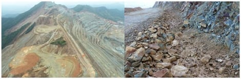
Dabaoshan open-pit stope.
  • Article
  • Open Access

Hyperparameter Optimization of Convolutional Neural Networks Using the Grey Wolf Optimizer for Mineral Prospectivity Mapping

  • Mobin Saremi,
  • Seyyed Ataollah Agha Seyyed Mirzabozorg and
  • Zohre Hoseinzade
  • + 4 authors

Convolutional neural networks (CNNs) have shown considerable potential for mineral prospectivity mapping (MPM); however, their predictive performance largely depends on appropriate hyperparameter optimization. In practice, hyperparameters are commonly selected through trial and error, which is labor-intensive, time-consuming, and often depends on user’s experience with both the application domain and the algorithm. This study investigates the use of the grey wolf optimization (GWO) algorithm to automatically optimize the hyperparameters of a lightweight CNN for regional-scale MPM. To demonstrate the proposed procedure, the Pariz porphyry copper district in Kerman province, Iran, was selected as a case study. Seven evidence layers representing different ore-forming subsystems were generated based on the geological characteristics of the region and a conceptual model of porphyry copper mineralization, and subsequently integrated using both the proposed GWO-CNN model and an expert-tuned CNN. The results of cross-validation show that neither model consistently outperformed the other across conventional classification metrics. The GWO-CNN outperformed the expert-tuned CNN in terms of AUC (0.8 versus 0.76), whereas both models achieved the same mean accuracy. However, in terms of exploration-oriented evaluation, the prediction-area (P-A) plot showed a higher prediction rate for the GWO-CNN (76%) than for the expert-tuned CNN (73%). The performance evaluation highlights the importance of considering prospective area in model evaluation. In addition, the final prospectivity map delineated several exploration targets that show strong spatial associations with intrusive rocks and other favorable geological features related to porphyry copper mineralization. Some targets, however, were identified in areas characterized by weak mineralization-related signals and no known mineral occurrences (KMOs). From the perspective of the survival bias concept, these areas may represent opportunities for future mineral discoveries at depth.

Mining

3 October 2026

Location of the KCMB in the southeastern part of the UDMA [34] (a), the location of the Pariz study area within the KCMB [34,82] (b), and the geological map of the Pariz study area that shows the main lithological units, faults, and known porphyry copper occurrences (c).
  • Article
  • Open Access

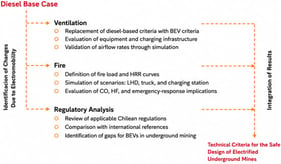
The transition to battery electric vehicles (BEVs) in underground mining offers an opportunity to eliminate direct combustion emissions and optimize ventilation, but it introduces new challenges for emergency management and operational safety. This study assesses the impact of that transition on ventilation requirements and on the fire behavior of mining equipment. Air demand was compared between equivalent diesel and electric fleets of load-haul-dump units and trucks, and fire scenarios were modeled through computational ventilation simulation. Thermal failure events in lithium-ion batteries of loading, haulage, and charging infrastructure were analyzed using heat release rate curves whose magnitude was computed from the declared fire load of each unit and whose temporal structure was taken from full-scale tests reported in the technical literature, and the Chilean regulatory framework was reviewed and compared with relevant international regulations, standards, and guidelines applicable to ventilation and emergencies. The results show a reduction in the unit airflow requirement for most of the BEV equipment evaluated, while acceptable thermal conditions are maintained under the modeled scenario. However, the fire simulations generate high concentrations of toxic gases, particularly carbon monoxide and hydrogen fluoride, which compromise habitability and evacuation. Gaps in the Chilean regulatory framework are also identified in ventilation criteria for electric fleets, charging and battery-swapping stations, gas monitoring, and emergency strategies. These results provide the technical criteria for the design of safe and sustainable electrified underground mines in Chile, while offering insights that may also be relevant to other mining jurisdictions undergoing similar transitions.

Mining

3 October 2026

Methodological scheme applied in the study.
  • Article
  • Open Access

Tailings ponds associated with the beneficiation of low-grade sulphide ores are a recognized source of acid mine drainage (AMD) and heavy metal contamination in receiving watercourses. This study assesses the physicochemical quality of process water stored in the Valea Șesei tailings pond, which receives flotation tailings from the Roșia Poieni porphyry copper deposit (Apuseni Mountains, Romania), and evaluates the impact of its discharge on the Arieș River. Ten water samples were analysed for pH, dissolved oxygen, turbidity, conductivity, total dissolved solids, salinity, hardness, and dissolved copper and iron (ICP-OES). Water within the tailings pond was strongly acidic (pH as low as 3.27), with elevated conductivity and turbidity consistent with active AMD generation; pH and conductivity were negatively correlated (r = −0.68), a signature characteristic of sulphide oxidation. At the discharge point, copper and iron concentrations exceeded Romanian STAS 4706/1988 limits by two orders of magnitude and remained 30- to 40-fold above the limit in the Arieș River after dilution. Recomputing exceedances against the current NTPA-001/2002 normative altered this picture for iron, while copper remained non-compliant under both standards. These results confirm a measurable impact of tailings pond discharge on downstream water quality and highlight the need for regular monitoring against current regulatory thresholds.

Mining

1 October 2026

Schematic alteration zonation of the Roșia Poieni porphyry system (not to scale; qualitative): a potassic core (biotite, K-feldspar, quartz, chlorite, anhydrite; chalcopyrite–pyrite–minor bornite) around the Fundoaia microdiorite intrusion, overprinted by a phyllic zone (quartz, phengite, illite; pyrite-dominant, texturally abundant) and by a later, spatially irregular advanced-argillic assemblage (alunite, kaolinite, pyrophyllite), within Middle Miocene andesitic country rock. Redrawn as an original schematic from the zonation described in Milu et al. [9]; this diagram is not a reproduction of any previously published map and does not depict true areal extent or geometry.

Highly Accessed Articles

News & Conferences

Latest Issues

Open for Submission

Journal Sections

Innovative Strategies to Mitigate the Impact of Mining
Reprint

Innovative Strategies to Mitigate the Impact of Mining

Editors: Chongchong Qi, Qiusong Chen, Danial Jahed Armaghani
Mine Automation and New Technologies
Reprint

Mine Automation and New Technologies

Editors: Roohollah Shirani Faradonbeh, Robert Solomon, Phillip Stothard
XFacebookLinkedIn
Mining - ISSN 2673-6489