Systematic Review

Slope Stability Monitoring Methods and Technologies for Open-Pit Mining: A Systematic Review

1
School of Electrical Engineering, Computing and Mathematical Sciences, Curtin University, Perth 6102, Australia
2
Western Australia School of Mines: Minerals, Energy and Chemical Engineering, Curtin University, Perth 6102, Australia
*
Author to whom correspondence should be addressed.
Mining 2025, 5(2), 32; https://doi.org/10.3390/mining5020032
Submission received: 15 April 2025 / Revised: 7 May 2025 / Accepted: 16 May 2025 / Published: 17 May 2025
(This article belongs to the Special Issue Mine Automation and New Technologies)

Abstract

Slope failures in open-pit mining pose significant operational and safety issues, underscoring the importance of implementing effective stability monitoring frameworks for early hazard detection to allow for timely intervention and risk mitigation. This systematic review presents a comprehensive synthesis of existing and emerging methods and technologies used for slope stability monitoring in open-pit mining, including both remote sensing and in situ methods, as well as advanced technologies, such as Artificial Intelligence (AI), the Internet of Things (IoT), and Wireless Sensor Networks (WSNs). Using the Preferred Reporting Items for Systematic Reviews and Meta-Analysis (PRISMA) 2020 guidelines, a total of 49 studies were selected from a collection of four engineering databases, and a comparative analysis was conducted to determine the underlying differences between the various methods for open-pit slope stability monitoring in terms of their performance across key attributes, such as monitoring accuracy, spatial and temporal coverage, operational complexity, and economic viability. Their juxtaposition highlighted the notion that no universally optimal slope stability monitoring system exists, due to a series of compromises that arise as a result of inherent technological limitations and site-specific constraints. Notably, remote sensing methods offer large-scale, non-intrusive monitoring, but are often limited by environmental factors and data acquisition infrequency, whereas in situ methods provide high precision, but suffer from limited spatial coverage and scalability. This review further highlights the capacity of emerging methods and technologies to address these limitations, providing suggestions for future research directions involving the integration of multiple sensing technologies for the enhancement of monitoring capabilities. This study provides a consolidated knowledge base on open-pit slope stability monitoring methods, technologies, and techniques, to guide the development of integrated, cost-effective, and scalable slope monitoring solutions that enhance mine safety and efficiency.

1. Introduction

1.1. Background and Context

Open-pit mining is a cornerstone of Australia’s resources sector, facilitating the extraction of valuable commodities, such as iron ore, coal, and gold. Open-pit mines are typically developed as a series of descending benches excavated into the earth, with haul ramps providing access from the surface to the pit floor, as shown in Figure 1. The resulting pit walls, or slopes, are often steep and geotechnically complex, and are inherently susceptible to failure, due to geological discontinuities, such as joints, bedding planes, and faults, which serve as potential planes of weakness within the rock mass [1].
Over a two-year period, spanning from 2018 to 2020, five slope failures were reported across Western Australian open-pit mines, leading to significant asset and infrastructure damage. During that same period, two fatalities occurred as a result of slope failures in open-pit mines in Queensland and the Northern Territory, underscoring the severe consequences of inadequate slope stability monitoring [2].
Slope failures can occur due to a range of internal and external factors, including geological discontinuities, weak rock masses, and weathering, which reduce the inherent strength of the slope; as well as external triggers, such as heavy rainfall infiltration and groundwater variation, which increase pore water pressure and reduce shear strength; seismic activity, which can induce vibrations that destabilize rock masses; and mining-induced disturbances, such as blasting and excavation, which can undercut or overload the slope, disrupting its equilibrium and triggering slope failure [3,4]. As shown in Figure 2, the four primary failure mechanisms for open-pit slopes, which can be initiated by the aforementioned factors, are:
  • Plane failure, wherein a large section of the pit wall slides along a planar surface, often controlled by pre-existing discontinuities, such as bedding planes, joints, or faults [5];
  • Wedge failure, the most common and hazardous mode of slope failure in open-pit mines, resulting from the intersection of two structural planes, which form a wedge-shaped rock mass, that can detach under the effects of gravity or external forces and descend the slope [6];
  • Circular failure, in which geological material is displaced vertically along a curved failure plane, most commonly observed in slopes with relatively uniform, homogenous materials, like cohesive soils or weathered rock [7];
  • Toppling failure, which occurs when steeply inclined rock columns or blocks overturn due to gravity, undercutting, or external forces, such as water infiltration or seismic activity [8].
Given these risks, effective slope stability monitoring is critical to ensure mine safety and operational continuity. The primary goal of slope stability monitoring is to detect and monitor the rate of slope displacement, as increasing displacement rates are typically indicative of incipient slope failure. It is widely understood that slope failures rarely occur without warning, developing instead from progressive, cumulative displacement over time and, for this reason, the early detection of slope failure indicators is essential in order to enable mine operators to intervene and mitigate risks [1].
Slope monitoring methods, broadly, fall into one of the following categories, based on the manner of data acquisition:
  • Sub-surface monitoring, which measures movements deep within the weathered material of open-pit slopes;
  • Surface monitoring, which detects visible signs of instability and quantifies surface-level deformations and displacements.
Conventional slope monitoring approaches have long relied on the use of geotechnical instruments and geodetic surveys to quantify slope displacements. While advancements in technology have enhanced these processes, there remains a fragmented understanding of the comprehensive landscape of slope stability monitoring methods available in regard to open-pit mining, attributed to the lack of review papers critically appraising existing and emerging methods [4]. For this reason, a systematic review is necessary to synthesize research in the field, to provide an objective assessment of current methods, and to identify gaps requiring further investigation, with the overarching goal of developing strategies for the future of real-time open-pit slope stability monitoring.

1.2. Objectives and Research Questions

This systematic review aims to consolidate knowledge in the field of open-pit slope stability monitoring, with the goal of examining both existing and emerging methods and trends to determine their inherent strengths and weaknesses. The PRISMA 2020 guidelines were adapted for use in this systematic review in order to follow an explicit and reproducible search methodology, ensuring a comprehensive synthesis of the most relevant research on slope stability monitoring methods. The Research Questions (RQs) guiding this systematic review were derived using the outputs from the Population, Intervention, Comparison, Outcome (PICO) mnemonic [9], as documented in Table 1.
Using the PICO criteria from Table 1, the following RQs were established:
  • What are the most widely used monitoring methods for open-pit slope stability, and what are their comparative advantages and disadvantages?
  • What are the emerging trends in continuous and autonomous open-pit slope stability monitoring?
The remainder of this systematic review is structured as follows: Section 2 details the study selection methodology used, while Section 3 presents the search results in the context of answering the aforementioned RQs. Section 4 provides a discussion of the implications of the key findings ascertained from the review, and offers recommendations for future studies, while Section 5 concludes by restating our findings and summarizing our primary arguments.

2. Methods

2.1. Eligibility Criteria

To ensure that the selection process captured only relevant studies, predefined study characteristics were established to determine the eligibility of studies for inclusion in the review, as presented in Table 2.

2.2. Information Sources

The primary focus of this systematic review was to explore existing and emerging methods for monitoring open-pit slope stability. For this reason, the information sources, or databases, used in this review were selected due to their comprehensive coverage of contemporary research in the field of engineering, as illustrated in Table 3.

2.3. Search Strategy

The search strategy used for this systematic review was designed to comprehensively capture relevant studies on open-pit slope stability monitoring across the selected databases. Using the PICO mnemonic criteria from Table 1, a series of keywords and synonyms were developed, as shown in Table 4, which were tailored towards the research scope.
Using these keywords and synonyms, a database search query was developed using a combination of Boolean operators, as demonstrated in Table 5.
The purpose of this database search query was to ensure that any relevant studies discussing slope stability monitoring, in the context of open-pit mining, would be captured, regardless of the specific wording of their titles. Filters were also applied to limit the search results to peer-reviewed journal articles, conference papers, and review papers published within the last 20 years, from March 2005 to March 2025.

2.4. Quality Assessment

Following the PRISMA 2020 guidelines, a quality assessment was conducted using the criteria suggested by [10], to ensure that only methodologically sound and reliable studies were included in the systematic review. Each study was evaluated based on four criteria, documented in Table 6, and those that scored below the cumulative threshold of five points were excluded.

2.5. Study Selection Process

The selection process for this systematic review followed the PRISMA 2020 guidelines using a structured, multi-stage approach to ensure that the included studies were relevant to the research scope and consistent with the inclusion criteria, with Parsifal (https://parsif.al/ accessed on 26 February 2025) serving as a central repository to facilitate study import, quality assessment, data extraction, and analysis. Study selection was conducted on 26 February 2025, with the search results compiled shortly thereafter, following these steps:
  • Searched selected databases using the Boolean search query and exported the results to Parsifal for screening;
  • Identified and removed duplicate studies through manual and automated review in Parsifal;
  • Assessed articles for relevance through title and abstract screening, and excluded studies that were misaligned with the review scope;
  • Conducted a full-text assessment of each study, evaluating them against the eligibility criteria and quality assessment guidelines;
  • Extracted selected studies into a standardized study characteristics table, and categorized each included study based on its primary focus in terms of the monitoring methods used.

3. Results

3.1. Study Selection and Classification

As shown in Figure 3, a total of 644 studies were retrieved from the databases searched using the Boolean search query outlined in Table 5. After removing the duplicate studies, of which there were 29, the remaining 615 studies underwent screening, in which their titles and abstracts were read and assessed for relevance to the research scope. This resulted in the exclusion of 421 papers, with the remaining 194 studies undergoing a full-text appraisal against the eligibility criteria and quality assessment guidelines. A total of 145 papers were excluded at this stage, due to their misalignment with the RQs (103), inaccessibility (24), poor quality (4), and ineligibility (14). This resulted in a final selection of 49 studies, which were included in the systematic review.
The number of studies that were identified and included in this systematic review, broken down by their respective databases, are shown in Figure 4, which, unsurprisingly, demonstrates a high concentration of included studies from Scopus. ScienceDirect and IEEE Xplore both contributed equal proportions of studies, while studies published across the ASCE Library were not included in the final selection, namely due to the large proportion of duplicates found across this database, which were covered by the studies included from Scopus.
The trend, evidenced by Figure 5, reflects a gradual increase in the publication of studies about open-pit slope stability from 2010 onwards, peaking in 2022. Furthermore, the results clearly demonstrate the increased topicality of emerging trends and methods for open-pit slope stability monitoring around 2019 to 2022, with all the recent studies (2023 onwards) focusing solely on remote sensing methods. Mentions of in situ methods occur more commonly in less recent studies, with all the publications in 2017 solely focused on this stability monitoring category. Despite this, 2022 saw a resurgence in studies about in situ monitoring, namely associated with their retrofitting using emerging technologies, such as the IoT and WSNs; however, this trend appears to have tapered off in the following years.
During the study selection process, the included studies were categorized based on the type of open-pit slope stability monitoring method they predominantly focused on. These slope stability monitoring methods, which were identified from the results of the systematic review, are shown in Figure 6.
With reference to Table 7, the majority of the included studies focused on remote sensing techniques (76%), while the remaining 24% examined in situ methods for slope stability monitoring.

3.2. Remote Sensing Methods

The first question in this systematic review, RQ1, focused on analyzing the methods and technologies behind some of the most pertinent forms of slope stability monitoring, in order to gain a better appreciation of their comparative advantages and disadvantages. The first category of open-pit slope stability monitoring uncovered in this systematic review was remote sensing, which uses advanced sensors and techniques to detect slope displacements from afar, by monitoring surface-level changes. Enveloped within this stability monitoring category, the most commonly discussed methods were satellite-based radar, followed by digital photogrammetry, ground-based radar, laser scanning, geodetic surveying, and, finally, thermal imaging, as presented in Table 8.

3.2.1. Satellite-Based Radar

Satellite-based radar systems employ Synthetic Aperture Radar (SAR) to generate Digital Elevation Models (DEMs) and surface velocity maps, enabling the remote detection and monitoring of slope displacements. SAR operates by transmitting microwave pulses from orbiting satellites and recording the amplitude and phase of the backscattered signals. This allows for high-resolution imaging of the Earth’s surface regardless of atmospheric conditions, such as cloud cover or illumination [25].
To detect and quantify slope displacements over time, Differential Interferometric SAR (D-InSAR) is used. This technique exploits the phase component of the radar signal, which is sensitive to changes in the distance between the satellite and the ground surface. By acquiring two or more SAR images from successive satellite passes over the same area and precisely co-registering them, an interferogram is generated by computing the phase difference between corresponding pixels in the SAR images. The total phase difference contains contributions from several sources: satellite geometry, topography, surface displacement, atmospheric delay, and noise. In regard to D-InSAR, the topographic phase is removed using an external DEM, thereby isolating the displacement-related phase component. This residual phase is proportional to the change in the Line of Sight (LoS) distance between the satellite and the ground surface, allowing ground deformation to be measured with millimeter-level accuracy [20,23,34,35,38]. An example of this process is illustrated in Figure 7.
Persistent Scatterer Interferometric SAR (PS-InSAR) builds upon this technique by identifying and analyzing coherent targets, known as persistent scatterers, which exhibit stable phase behavior across a long time series of SAR acquisitions. These targets, such as buildings or exposed rock faces, provide consistent radar reflections that enhance temporal coherence. By modeling and correcting for atmospheric effects and orbital errors across multiple acquisitions, PS-InSAR achieves higher precision and robustness, enabling the detection of long-term, subtle deformations that are often missed by traditional Interferometric SAR (InSAR) approaches [29,33,34,38].
Satellite-based radar systems offer broad spatial coverage due to their orbital vantage point, with the ability to monitor large geographic regions in a single pass. Their LoS-based measurement geometry enables precise displacement measurements across wide areas [20,23,28,30,33,35,36,43]. Moreover, access to freely available satellite datasets, such as those from the European Space Agency’s Sentinel-1 mission, enhances the scalability and cost efficiency of SAR-based slope monitoring solutions [30].
However, several limitations affect the practical application of these techniques. The temporal resolution is constrained by satellite revisit intervals, which typically range from several days to weeks. This limits the ability of D-InSAR and PS-InSAR to capture rapid or sudden slope movements, which are characteristic of highly unstable areas [20,23,24,28,34,35,36,42,43]. Additionally, SAR techniques are susceptible to temporal decorrelation, especially in vegetated or rapidly changing environments, wherein the radar signal coherence between acquisitions deteriorates due to changes in the surface scattering properties. This degradation negatively impacts the quality of interferograms and reduces the accuracy of displacement measurements [25,33].

3.2.2. Digital Photogrammetry

Digital photogrammetry is a remote sensing technique that reconstructs Three-Dimensional (3D) models of objects or environments by fusing images captured from multiple angles. One of the most widely used methods in this context is Structure-from-Motion (SfM), a computer vision technique that recovers both the 3D structure of a scene and the camera’s motion path by identifying and tracking distinct visual features across overlapping images taken from different perspectives, as demonstrated in Figure 8.
The SfM process begins by detecting characteristic feature points in each image, using various algorithms from software packages such as Agisoft. These feature points are then matched across multiple images, allowing the photogrammetry software to compute the relative positions and orientations of the cameras through bundle adjustment, an optimization algorithm that minimizes the re-projection error of the matched points. Once the camera poses are determined, triangulation is applied to the matched feature points to derive their 3D coordinates, resulting in the generation of a 3D point cloud, which can be converted into a 3D mesh or surface model, such as a DEM, representing the terrain geometry. Cloud-to-cloud (C2C) nearest neighbor distance computation algorithms, such as Multiscale Model-to-Model Cloud Comparison (M3C2), commonly used in software packages such as Cloud Compare, can then be used to determine the relative displacement between iterative point cloud acquisitions, thereby quantifying slope displacements [39]. These 3D models provide engineers with high-resolution spatial data, enabling the detection and quantification of surface deformations, cracks, and geological structures with centimeter-level accuracy [39,40,47]. When applied to slope stability monitoring, SfM enables the comparison of 3D models generated at different times (i.e., multi-temporal analysis), facilitating the identification of small-scale surface displacements that might indicate progressive slope failure.
Additionally, the utility of SfM is greatly enhanced when paired with Unmanned Aerial Vehicles (UAVs), which provide flexible, high-resolution data acquisition over challenging and complex terrains. UAV-based photogrammetry enables the rapid and repeatable collection of imagery from multiple altitudes and angles, offering substantial coverage and resolution advantages over fixed ground-based systems [16,26,27,31,40,44,45,46,47]. Compared to traditional slope monitoring methods, photogrammetry offers several key advantages. It provides considerable operational flexibility, since UAV-mounted cameras can access remote or hazardous areas without placing personnel at risk, supporting safer and more efficient inspections [26]. The method is also cost effective, leveraging low-cost, consumer-grade equipment, which makes it significantly more affordable than laser scanning or terrestrial radar interferometry systems [24,26,31]. In addition, the approach delivers high-resolution spatial data, with dense 3D reconstructions offering a comprehensive and detailed view of the slope surface, often with centimeter-level accuracy, depending on the flight altitude and camera quality [39,40,47]. Finally, its ability to support on-demand and frequent monitoring allows UAVs to be deployed as needed, such as after rainfall events or signs of instability, enabling timely assessments of slope behavior and a rapid response to emerging risks [26].
Despite these benefits, the method has limitations. UAV-based photogrammetry is constrained by short flight times, battery limitations, and weather dependency, including reduced performance in rainy or windy conditions [24,27]. Furthermore, low-light conditions or dense vegetation can degrade image quality, making data collection difficult at night or in shaded terrain [47]. The process also requires intensive computation, particularly during point cloud generation and model reconstruction, which limits its suitability for real-time monitoring applications [26,45,46].

3.2.3. Ground-Based Radar

Ground-based radar, much like its satellite-based counterpart, uses SAR to detect and monitor slope displacements. Unlike space-borne SAR, which uses orbital satellites to capture high-resolution spatial images, ground-based radar systems use fixed, stationary equipment, located on the ground, close to the area of interest, that move linearly along a rail to capture SAR images, as demonstrated in Figure 9 [21].
The primary advantage of this is that ground-based radar systems can achieve high-frequency deformation monitoring in real-time [19,21]. Ground-based radar provides sub-millimeter levels of accuracy and the capacity to produce detailed DEMs through techniques such as Ground-Based InSAR (GB-InSAR), which compares multiple SAR acquisitions and measures their phase differences to quantify slope displacements, much like satellite-based D-InSAR [11,12,13,18,19,21,22]. However, in order to achieve this accuracy, ground-based radar necessitates stable installation and favorable weather conditions, as shadows and rain can introduce noise and impact signal propagation, thereby impacting its suitability and efficacy in regions with undesirable climates [12].

3.2.4. Laser Scanning

Light Detection and Ranging (LiDAR) is a laser-based remote sensing technology that generates high-resolution 3D point clouds of slope surfaces, facilitating the monitoring of erosion, slope failures, and subtle displacement trends through the analysis of visualizations, such as DEMs. LiDAR operates by emitting pulses of light that reflect off objects and return to the receiver. The Time of Flight (ToF) for each pulse is then measured and used to calculate the distance to the object, which allows for the derivation of precise 3D coordinates for each reflected point [11,14,16,37]. Laser scanning facilitates rapid data acquisition, yielding near real-time slope stability monitoring [37,41]. LiDAR data acquisition can be conducted using stationary Terrestrial Laser Scanners (TLSs) [11,14,16,17,28,32,37,41] or mobile UAVs [45].
A TLS provides higher accuracy and is capable of sub-millimeter precision [32], making it well-suited for detailed geotechnical assessments. Conversely, UAV-mounted LiDAR provides enhanced spatial coverage, allowing for large-scale, flexible monitoring of open-pit slopes. However, laser scanning is impacted by several factors. Its effectiveness is highly dependent on the LoS, as obstructions, such as vegetation, can reduce point cloud density [14,17,32]. Additionally, the influence of atmospheric conditions, such as rain and the reflectivity of surfaces, can negatively impact signal propagation, affecting measurement accuracy [37].

3.2.5. Geodetic Surveying

Geodetic surveying uses instruments such as Total Stations (TSs), the Global Positioning System (GPS), and Pseudolites (PLs), for high-precision deformation monitoring over vast areas [14,15,20]. These methods provide autonomous, real-time slope stability monitoring, with millimeter-level precision [57].
Among the available geodetic instruments, TSs are perhaps the most commonly used in geological surveying, operating by measuring the variations in the angles and distances between a fixed sensor and various reflective prisms located across an open-pit slope surface. Through repeated surveying, TSs can detect progressive slope movements with high precision, allowing for the tracking of long-term deformation trends. As demonstrated in Figure 10, GPS and PL technologies use differential positioning techniques to determine the relative distances between receivers deployed across an open-pit slope [14,20].
By tracking the changes in spatial coordinates, GPS-based monitoring can detect millimeter-level slope displacements [4]. PLs act as supplementary transmitters that serve to augment GPS signal coverage in areas, such as deep open pits, where the satellite LoS might be obstructed. By integrating these technologies, monitoring networks can be established that achieve enhanced stability, negating the implications of multipath errors, which often degrade GPS measurement effectiveness [15]. Despite their real-time monitoring capabilities and strong measurement accuracy, TSs are dependent on a clear LoS and optimal weather conditions [14]. While PLs provide enhancements to GPS signal quality, their effectiveness is dependent on the positioning and configuration of orbital satellites, meaning that optimal PL positioning requires meticulous planning and may be dependent on available satellite passes, which can hinder its ability to reduce GPS multipath errors in real time [15].

3.2.6. Thermal Imaging

Thermal imaging, such as Infrared Thermography (IRT), is an emerging remote sensing technique, used to detect regions of geological instability in open-pit slopes by analyzing thermal radiation patterns. Similar to the other remote sensing methods discussed, IRT works by measuring the infrared radiation emitted by surfaces, allowing for the generation of heat maps that visualize temperature variations across terrains. These variations, which often manifest as negative temperature anomalies, can serve as indicators of precursory slope failure. While IRT offers non-contact, localized monitoring, it has several limitations, including signal attenuation due to atmospheric conditions, which can cause signal degradation over long measurement ranges [28].

3.2.7. Summary of Remote Sensing Methods

Table 9 presents a high-level summary of the remote sensing methods discussed throughout this section, highlighting their key characteristics and performance attributes.

3.3. In Situ Monitoring Methods

While remote sensing techniques enable large-scale, non-contact monitoring, they are primarily used to measure surface-level displacements. In contrast, in situ methods provide direct, high-precision monitoring of both surface and sub-surface slope movements. These methods rely on traditional geotechnical instrumentation and advanced sensors to track slope displacement directly. The most commonly used in situ technologies include TDR, extensometers, piezometers, advanced sensors, and inclinometers, as shown in Table 10.

3.3.1. Time Domain Reflectometry

Time Domain Reflectometry (TDR) is an in situ monitoring method used to detect slope deformations that occur at the sub-surface level. TDR uses the working principle of transmission lines to detect localized strain and deformation by measuring the reflection of electromagnetic pulses sent along a coaxial or fiber optic cable embedded within a borehole in a slope. This method provides high-resolution, real-time slope stability monitoring, enabling the detection of cracks or internal displacements along the buried wire’s length [51,55,58].
Characteristic impedance varies based on a myriad of factors and is dependent on the physical parameters and dimensions of the transmission line. Shear stress and tensile strain are common by-products of sub-surface slope displacement, and these forces can affect the characteristic impedance of the wire, causing portions of transmitted pulses to reflect back to the TDR sensor [60], as demonstrated in Figure 11.
By analyzing the travel time of the reflected pulse, the exact location of displacements can be determined with sub-millimeter precision [48], while variations in the amplitude of the signal can be used to provide an estimate of the magnitude of deformation [58]. Due to the use of durable materials, such as optic fiber cables, TDR excels in harsh environments, such as deep boreholes, making it well-suited for long-term slope stability monitoring [58]. For this reason, TDR is a fairly economical in situ monitoring technique [59].
Despite this advantage, TDR installation is often a complex procedure, requiring extensive drilling [55,58]. This discrete, point-based installation procedure also means that TDR has a limited spatial resolution, making it less effective for capturing distributed slope deformation trends across vast areas.

3.3.2. Extensometers

Visual indicators of slope failure, such as tensile cracks, are commonly monitored by using in situ techniques [3], such as wireline extensometers [55,57,58]. These geotechnical devices measure the dilation of cracks by detecting changes in the displacement of a wire that is anchored to the unstable portion of ground, as per Figure 12.
Traditionally, changes in the length of the wire were measured manually [57]; however, the advent of modern sensors, such as vibrating wire displacement transducers, has digitized this process, allowing for remote and continuous slope stability monitoring [58]. Extensometers are widely used in slope stability monitoring [55,56,57,58,59], due to their high precision, with some systems capable of detecting sub-millimeter deformations under optimal conditions [56]. Like the other in situ monitoring methods, extensometers require fixed, stable anchor points, impacting the ease of deployability.

3.3.3. Piezometers

Elevated pore water pressure reduces the effective stress in soils, weakening them and contributing to slope failure [6,7,8]. To combat this, piezometers are installed in open-pit slopes to quantify and monitor groundwater fluctuations. Traditional piezometers require manual, periodic data acquisition; however, modern sensors, such as automated pressure transducers, have enabled real-time, continuous monitoring of pore water pressure [56,57]. The discrete, point-based installation of piezometers means that they have a limited spatial resolution; however, this can be overcome by installing an array of sensors across vast spaces for increased coverage. Their deployability is also limited by their installation methodology, as they are often placed within boreholes, which requires extensive drilling [59].

3.3.4. Advanced Sensors

Modern sensor technologies provide alternative ways to detect physical phenomena such as strain and slope displacement. The first of these methods uses Fiber Bragg Grating (FBG) sensors, which use fiber optic technology to detect sub-surface displacements in real-time by measuring strain-induced shifts in the wavelength of reflected pulses of light. This allows FBG sensors to locate strain accumulation and detect tensile crack formation and dilation, with sub-millimeter accuracy. These sensors are highly durable and immune to electromagnetic interference (EMI), due to their use of fiber optic cables. Furthermore, they can be daisy chained to provide distributed sensing over vast distances, increasing their spatial resolution [49]. Inertial Measurement Units (IMUs) are advanced sensors that contain an accelerometer, gyroscope, and magnetometer to measure triaxial linear acceleration and angular velocity simultaneously. By applying sensor fusion algorithms, IMUs track object motion and orientation in 3D space, with high precision. IMUs are able to effectively identify the motion patterns associated with various modes of slope failure, such as toppling failure [59]. Additionally, by combining sensors capable of measuring both force and deformation, a far more comprehensive analysis of the internal dynamics of slope behavior can be attained, with sub-millimeter precision, in real time [53]. Similar to the other in situ monitoring methods, advanced sensors, despite providing precise localized measurements, lack broad spatial coverage, as they rely on discrete point measurements rather than continuous spatial data [49,52,53]. This makes them less effective for detecting widespread slope instabilities without the use of extensive sensor networks.

3.3.5. Inclinometers

Among the available geotechnical instrumentation, borehole inclinometers are widely used for slope stability monitoring [56,57,58,59], due to their ability to measure localized angular deformation and detect sub-surface displacement trends. Borehole inclinometers use Micro-Electro-Mechanical System (MEMS) sensors and probes to detect differential movements in real time, with sub-millimeter accuracy. As deformation within the slope occurs, due to shearing forces, for instance, the inclinometer measures the change in the inclination of the sensor, relative to its initial position, which allows for the quantification of the rate and magnitude of sub-surface displacement [4], as shown in Figure 13.
Continuing the trend seen across in situ monitoring methods, the predominant limitation of borehole inclinometers is enveloped within their complex and invasive installation procedure, which requires specialized drilling, increasing operational and maintenance costs [59].

3.3.6. Summary of In Situ Monitoring Methods

Table 11 provides an overview of the in situ monitoring methods discussed, summarizing their measurement accuracy, spatial coverage, and temporal resolution, as well as key advantages and limitations.

3.4. Comparison of Monitoring Method Categories

The previous sections outlined the most common remote sensing and in situ monitoring methods used for open-pit slope stability monitoring. While each method ultimately works towards the same common goal, their effectiveness varies widely based on a myriad of factors, such as measurement precision, spatial coverage, and temporal resolution, due to the inherent differences in the underlying technologies, sensors, and data processing techniques used. These systemic differences are presented in Table 12, which contrasts the key performance attributes associated with the slope stability monitoring methods commonly used in open-pit mining.
Table 11. Summary of in situ monitoring methods for open-pit slope stability monitoring.
MethodAccuracySpatial CoverageTemporal
Resolution
AdvantagesLimitations
Time Domain Reflectometry<1 mmLocalizedReal timeVery precise, cost effective for long-term monitoringRequires borehole installation, limited to predefined zones
Extensometers<1 mmLocalizedReal time or PeriodicAccurate for uniaxial measurementsPoint-based over predefined instabilities (e.g., tensile cracks)
PiezometersN/ALocalizedReal timeReliable for pore water pressure monitoringInstallation challenges, affected by groundwater fluctuations
Advanced Sensors<1 mmLocalizedReal timeHighly accurate and adaptableRequires expert installation and data interpretation
Inclinometers<1 mmLocalizedReal time or PeriodicWell-established method, reliableRequires borehole installation, operationally inflexible

3.5. Emerging Trends in Open-Pit Slope Stability Monitoring

Traditional slope stability monitoring methods have inherent limitations and weaknesses that impact their overall effectiveness, as discussed in the prior section. However, advancements in technology have continued to drive innovations in slope stability monitoring in an effort to address these shortcomings. As shown in Table 13, of the 49 studies included in the review, 12% discussed emerging trends, such as the IoT, WSNs, and the growing role of AI and Machine Learning (ML) in detecting and analyzing indicators of slope failure. In response to RQ2, this section explores these advancements, highlighting the underlying technologies, strengths, and limitations.

3.5.1. Improved Failure Detection Using Artificial Intelligence

Computer vision is increasingly being applied to slope stability monitoring to enhance predictive modeling and provide early failure detection. Computer vision leverages neural networks, a subset of ML, to enable computers to interpret and analyze visual data from the world around them. In the context of slope stability monitoring, computer vision can be used to detect tensile cracks [46] and other surface anomalies that are indicative of deformation [54].
The process starts with data acquisition using UAVs [46] or ground-based cameras [54], followed by processing techniques, such as noise reduction, data augmentation, thresholding, and edge detection. This breaks the image into smaller segments, which undergo feature extraction, wherein characteristics, such as crack patterns [46] and contours around deformed areas [54], are extracted using advanced algorithms and analyzed through Convolutional Neural Networks (CNNs) [46], which recognize, classify, and categorize these deformations. Like other remote sensing methods, a primary advantage of the use of AI-driven failure detection systems, such as the computer vision approaches outlined in [46,54], is their ability to automate manual processes and reduce operational risk. As stipulated by [46], visual inspection is still the most effective way for geotechnical engineers to identify and track tensile crack formation in open pits; however, this is an inherently hazardous process. The application of advanced ML failure detection models, as illustrated in the literature, can enhance and streamline this process.
Despite the qualitative nature of these approaches, their object detection precision is strong, with more robust algorithms, such as the Efficient Neural Network (ENet) [46] and the Improved Region Growing Segmentation Method (IRGSM) [54], achieving only a few false positives during testing. This accuracy comes at a cost to the temporal resolution, however, due to the high computational demands associated with image processing in computer vision applications [46]. Furthermore, the effectiveness of computer vision is limited when monitoring complex environments that may be heavily textured or shaded [46,54], as detection algorithms may flag false positives, affecting detection reliability. In addition to this, CNN-based image classification also requires large, high-quality datasets for training, increasing the complexity and resource demands of implementing computer vision for slope stability monitoring [46].

3.5.2. Industrial Automation for Real-Time Monitoring

The unification of the IoT and WSNs provides an avenue for industrial automation, by enabling automated data acquisition for real-time open-pit slope stability monitoring. The IoT refers to a network of ubiquitous, interconnected devices that collect, share, and interpret data remotely, while WSNs consist of spatially distributed sensor nodes that wirelessly communicate geotechnical and environmental measurements [59], such as displacement [52] and strain [48,50].
In the context of open-pit mining, Industrial IoT (IIoT) systems use smart sensors, processes, such as edge computing, and cloud-based platforms to automate and interpret slope stability data. The integration of WSNs with the IoT improves slope stability monitoring by allowing for the provision of real-time stability alerts, centralized data storage, and remote accessibility. In situ methods, such as TDR, can be enhanced through IoT-enabled sensor networks, which enable real-time, automated detection of slope deformation trends, and centralized data processing in the cloud [48]. WSNs augment the spatial coverage of sensing systems through the deployment of an array of low-power, wireless sensor nodes [50], enabling large-scale data acquisition over vast distances, while IoT infrastructure facilitates wireless data transmission and analysis. The primary advantage of this combined approach lies in its ability to provide a cost-effective and scalable alternative to in situ monitoring that minimizes infrastructure requirements, while enabling large-scale deployments in potentially hazardous or inaccessible environments [48,52,59]. Additionally, AI-driven analytics and real-time cloud computing provide these systems with enhanced failure detection, predictive analytics, and early risk mitigation capabilities [59].
Despite these transformative capabilities, two primary limitations constrain unified IoT–WSN slope stability monitoring. While recent advancements in the field of wireless communications have resulted in the development of energy-efficient techniques, such as Long Range (LoRa), power consumption remains a limiting factor, as sensor nodes require long-term energy solutions to remain operationally viable [52]. Additionally, due to the heterogeneous nature of the IoT, its lack of protocol standardization poses potential threats to data security and network vulnerability [59].

4. Discussion

4.1. Key Findings: Traditional Open-Pit Slope Stability Monitoring Methods

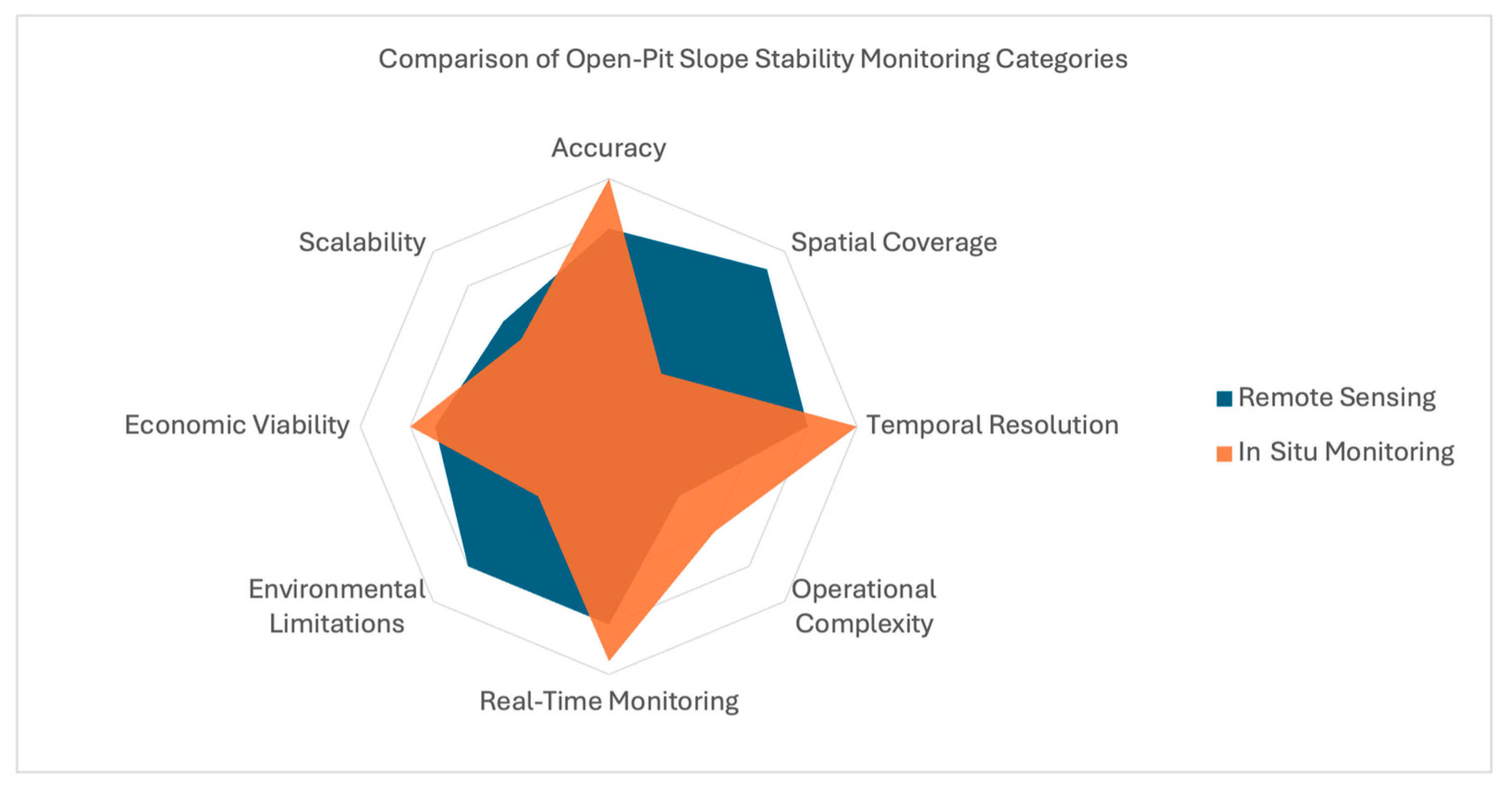
This systematic review examined a comprehensive collection of slope stability monitoring methods used in open-pit mining, with a focus on their accuracy, spatial coverage, and practical limitations. The findings reveal that significant trade-offs exist between key performance dimensions, as illustrated in Figure 14. Consequently, no single monitoring technique can be considered a universal or ‘gold standard’ solution, and, instead, the effectiveness of each method is highly context dependent, shaped by the specific geotechnical, environmental, and operational conditions of a given site.

4.1.1. Measurement Accuracy and Spatial Coverage

The results indicate that the trade-off between measurement accuracy and spatial coverage is, perhaps, the most polarizing difference between remote sensing and in situ monitoring. In situ monitoring methods, such as TDR and extensometers, provide a high degree of measurement accuracy by directly quantifying local strain, stress, and displacement within slopes [4,48,49,52,53,56]. However, their reliance on point-based measurements results in limited spatial coverage, impacting their ability to provide a holistic evaluation of overall slope stability.
In contrast, remote sensing methods, such as satellite-based radar and geodetic surveying, offer enhanced spatial coverage, enabling the detection of slope instabilities across vast areas [20,23,28,30,33,35,36,43,57]. This comes at a detriment to measurement precision, however, as these methods are highly susceptible to environmental interference, due to the indirect nature of the data acquisition process used [25,33]. This trend is further demonstrated by methods using UAV-borne digital photogrammetry and LiDAR, which, despite providing good spatial coverage, are constrained due to the inherent limitations associated with data interpolation [32,39,40,47]. However, this is only broadly the case, as the review findings suggest that some remote sensing methods, such as ground-based radar and TLS, can achieve a balance between accuracy and coverage due to their fixed installation, allowing for slope stability coverage over moderately large areas [19,21,32]. For this reason, it can broadly be surmised that remote sensing covers larger areas, but may have lower precision, while in situ monitoring provides high-precision, localized open-pit slope stability monitoring.

4.1.2. Temporal Resolution and Real-Time Monitoring

The relationship between the temporal resolution of slope stability monitoring methods and their real-time monitoring capabilities are a pertinent example of the compromises that can arise due to the underlying technologies associated with each monitoring technique. The most prominent example of this is the low temporal resolution of satellite-based radar, which can vary from several days to weeks, due to the infrequency of satellite passes used to acquire SAR spatial images. For this reason, D-InSAR and PS-InSAR are unsuitable for real-time, continuous open-pit slope stability monitoring, due to the underlying limitations of the InSAR technique and its dependence on satellite revisit times [20,23,24,28,34,35,36,42,43].
Contrary to this, in situ monitoring methods have unanimously high temporal resolutions, with sensors capable of continuous, near real-time data acquisition, due to their high sampling rates [51,55,56,57,58,59]. Despite the temporal limitations of satellite-based radar, other remote sensing methods demonstrate enhanced real-time monitoring capabilities, depending on the sensing technologies used. Ground-based radar and geodetic surveying provide real-time subsidence monitoring, due to their use of high-frequency sensing instrumentation [19,21,26,28,37,41,57]. UAV-borne digital photogrammetry and LiDAR, laser scanning, and thermal imaging all provide frequent, yet periodic, slope stability monitoring, due to the need for data post-processing [26,45,46], achieving a balance between the temporal resolution and monitoring frequency. While the ability of remote sensing methods to provide continuous slope stability monitoring varies from method to method, as shown in Figure 15, it is broadly evident that in situ techniques are better equipped for real-time data acquisition and monitoring, due to the inherently high temporal capabilities of their sensors.

4.1.3. Operational Complexity and Measurement Accuracy

The results suggest that the operational complexity and installation requirements of the monitoring methods are closely related to their overall effectiveness. The primary implication of this is that more accurate techniques are typically more costly due to the specialized infrastructure and maintenance associated with their implementation and operation [55,58,59], and this increased complexity impacts their accessibility, as evidenced by the shift in the industry towards open-source stability monitoring frameworks [30,43,44]. This relationship is most distinct across the in situ monitoring methods, which require specialized sensor installation within deep boreholes, allowing for precise, localized monitoring in predetermined failure zones [55,58,59].
These methods involve time-consuming and laborious installation, maintenance, and recalibration procedures [56]; however, their measurement accuracy and ability to capture sub-surface slope deformations justify their continued use in open-pit mining applications, despite their dwindling appearance in contemporary research (see Figure 5 and Table 7). Conversely, remote sensing methods provide a compromise between operational flexibility and monitoring efficacy due to their non-intrusive and cost-effective deployability. Both satellite-based radar and UAV-borne digital photogrammetry and LiDAR provide broad spatial coverage with minimal installation effort, making them well-suited for monitoring large slopes. However, this ease of deployment comes at the cost of measurement precision, as these remote sensing methods rely on indirect measurements and data interpolation, making them more susceptible to the effects of environmental interference [20,23,24,26,28,30,31,33,35,36,43]. Alternatively, stationary or fixed sensing equipment, such as ground-based radar and TLS, offer superior measurement accuracy, albeit at a detriment to operational complexity [11,12,13,18,19,21,22,32].

4.1.4. Environmental Limitations

The harsh environments found across many of the world’s open-pit mines can severely undermine many of the most common slope stability monitoring methods available, impacting both data quality and measurement accuracy. Remote sensing methods, such as digital photogrammetry, ground-based radar, geodetic surveying, laser scanning, and thermal imaging, all rely on clear atmospheric conditions and unobstructed visibility to accurately document surface-level slope displacements. Cloud coverage, rain, and dust can degrade image quality and impact signal propagation, introducing noise and artifacts that reduce measurement accuracy [11,12,14,27,28,37,47]. Additionally, remote sensing methods require a direct LoS to the target area, making them less effective in areas with dense vegetation, wherein obstructions can impact data acquisition and lead to unreliable results [25,33]. In contrast, in situ monitoring methods, like TDR, are less affected by environmental factors, given that they are properly installed, maintained, and recalibrated as needed. This is attributed to their use of durable materials, such as fiber optic cables, which are embedded deep within the sub-surface level of open-pit slopes [58,59].

4.1.5. Economic Considerations

The cost effectiveness of slope stability monitoring methods is broadly influenced by the balance between the initial investment costs associated with technology procurement and installation, long-term operational and maintenance expenses, and the overall risk mitigation benefits. Remote sensing methods exhibit inherent variability in their initial investment costs, due to the nature of the technology and sensors used. UAV-borne sensing using digital photogrammetry or LiDAR is considerably more economical than conventional laser scanning, geodetic surveying, and ground-based radar, due to its use of consumer-grade drones and digital cameras [24,26,31]. Satellite-based radar is similarly inexpensive due to the lack of infrastructural investment required by mine operators, who can, instead, tap into vast repositories of imaging data that are freely available via online databases [30].
The primary economic benefits associated with the use of remote sensing methodologies lie in their ability to reduce the need for manual inspections, minimizing personnel exposure to hazardous areas, while covering wide slope areas with minimal deployment efforts, yielding cost savings in the long term [26,30]. Despite the lower per unit cost of in situ monitoring methods using TDR, extensometers, piezometers, and inclinometers, their reliance on drilling boreholes and regular maintenance results in higher cumulative operational costs over time, particularly in large-scale mines where extensive monitoring is required [55,58,59]. The choice of monitoring method is, therefore, often the product of a myriad of factors, such as budget constraints, mine lifespan, and operational priorities. Remote sensing, broadly, provides a more cost-effective solution for large-scale, low-maintenance monitoring, while in situ methods remain the most accurate means for quantifying slope displacements in high-risk failure zones.

4.1.6. Suitability for Different Mine Conditions

The effectiveness of slope monitoring methods is heavily influenced by site-specific conditions, such as mine depth and visibility, slope geology, and external operational factors, such as the frequency of blasting. For deep pits with limited satellite visibility, geodetic surveying using technologies such as GPS can be impacted by the restricted LoS to satellites, degrading signal propagation and affecting measurement efficacy [14,15,20]. In such instances, ground-based radar and laser scanning provide enhanced monitoring capabilities by offering continuous, surface-level observations that are independent of any satellite constraints [21,37,41]. However, UAV-borne sensing using digital photogrammetry and LiDAR surpasses these approaches due to its unparalleled operational flexibility, allowing for remote maneuverability across vast terrains, unconstrained by elevation limitations [26].
The unique geology of each slope presents another challenge, as surface monitoring alone may not be sufficient to detect significant internal deformations, such as highly fractured rock masses. In these scenarios, in situ methods such as TDR and extensometers are more suitable, as they provide direct measurements of internal strain and shear deformation within the rock mass [55,58]. In active open-pit environments, frequent blasting is a common occurrence and, for this reason, the monitoring methods in use must account for the probability of rapid slope deformation. Ground-based radar and high-frequency geodetic surveying using TSs are particularly effective in these circumstances, due to their ability to provide real-time measurements and capture minute slope displacements, with high precision [19,26,50], with methods such as satellite-based radar being ineffective due to the limited temporal resolution [20,23,24,28,34,35,36,42,43]. In situ sensors also provide effective slope stability monitoring due to their real-time sensing capabilities, as per Table 11 and Table 12, given that they are equipped with wireless networking technologies for remote and automated data collection.

4.1.7. Scalability and Long-Term Viability

Open-pit mines are inherently large and expansive, with the long-term viability of slope stability monitoring methods depending, in part, on their ability to scale efficiently and effectively, all while maintaining consistent accuracy and reliability. Remote sensing methods are, predominantly, well-suited for large-scale slope stability monitoring, as discussed in Section 4.1.1, with the exception of digital photogrammetry and thermal imaging.
Despite this, UAV-borne sensing, in particular, is highly scalable for periodic inspections, as it allows for rapid deployment over large areas, without the need for extensive infrastructure, due to its operational flexibility [26]. Its scalability is, however, impacted by the inherent limitations associated with contemporary drone technology, such as limited battery life and payload capacity restrictions, impacting its continuous monitoring capabilities and long-term viability [24]. Traditional in situ monitoring techniques, while offering high accuracy, can be logistically challenging to the scale of large or complex mine sites. Geotechnical instruments, such as TDR, piezometers, extensometers, and inclinometers, for instance, require extensive installation within boreholes and are limited to predetermined areas of interest, reducing their overall operational flexibility and, therefore, their scalability [55,58,59].

4.2. Key Findings: Emerging Technologies for Open-Pit Slope Stability Monitoring

The findings from this systematic review highlight the transformative implications of the use of emerging technologies, such as AI, ML, the IoT, and WSNs, in improving the accuracy, efficiency, and scalability of slope stability monitoring in open-pit mines. As discussed throughout Section 4.1, traditional monitoring methods have inherent limitations and trade-offs need to be made; however, the results indicate that emerging technologies can remedy these challenges by improving failure detection, providing real-time monitoring, and digitizing and automating manual processes, as demonstrated in Table 14.

4.2.1. The Role of Artificial Intelligence

Perhaps one of the most significant benefits of using emerging technologies for open-pit slope stability monitoring is their ability to enhance failure detection and provide predictive analytics. While visual inspection remains a widely used and reliable method for identifying early signs of slope instability [54], it exposes personnel to hazardous environments and is inherently prone to subjectivity and human error, and, significantly, is unsuitable for high-risk or rapid failure zones [56]. AI and ML techniques, particularly computer vision-based approaches, augment traditional methods by leveraging ML methods like CNNs to automate slope failure detection.
As demonstrated in [46,54], AI-driven image analysis can remotely detect surface deformations, such as tensile cracks, with high precision, serving as an effective early warning system. Unlike traditional monitoring methods, which primarily measure slope displacement or forces such as stress and strain, AI models using computer vision focus on identifying visual indicators of slope failure, such as cracking, scarping, or raveling. The benefit of this approach lies in its ability to empirically and objectively detect significant precursory indicators of slope failure [1,5,6,7,8], which may be overlooked or missed during infrequent, manual site inspections. By providing continuous, automated detection, AI-driven models can reduce the need for personnel to conduct field inspections in hazardous conditions, thereby improving operational safety.
Despite these strengths, computer vision-based failure detection faces several challenges, akin to those seen across the other remote sensing methods. High computational demands, the risk of false positives due to complex terrains and environmental interference, and a dependence on large, high-quality datasets for ML model training, all impact its practical implementation [46]. Similar to digital photogrammetry and thermal imaging, AI-driven image analysis is also restricted by LoS limitations and, therefore, has a fairly localized spatial resolution. For this reason, AI-driven methods are most effective when used as complementary tools alongside traditional monitoring techniques, due to their inability to cover vast areas effectively in typical site conditions.

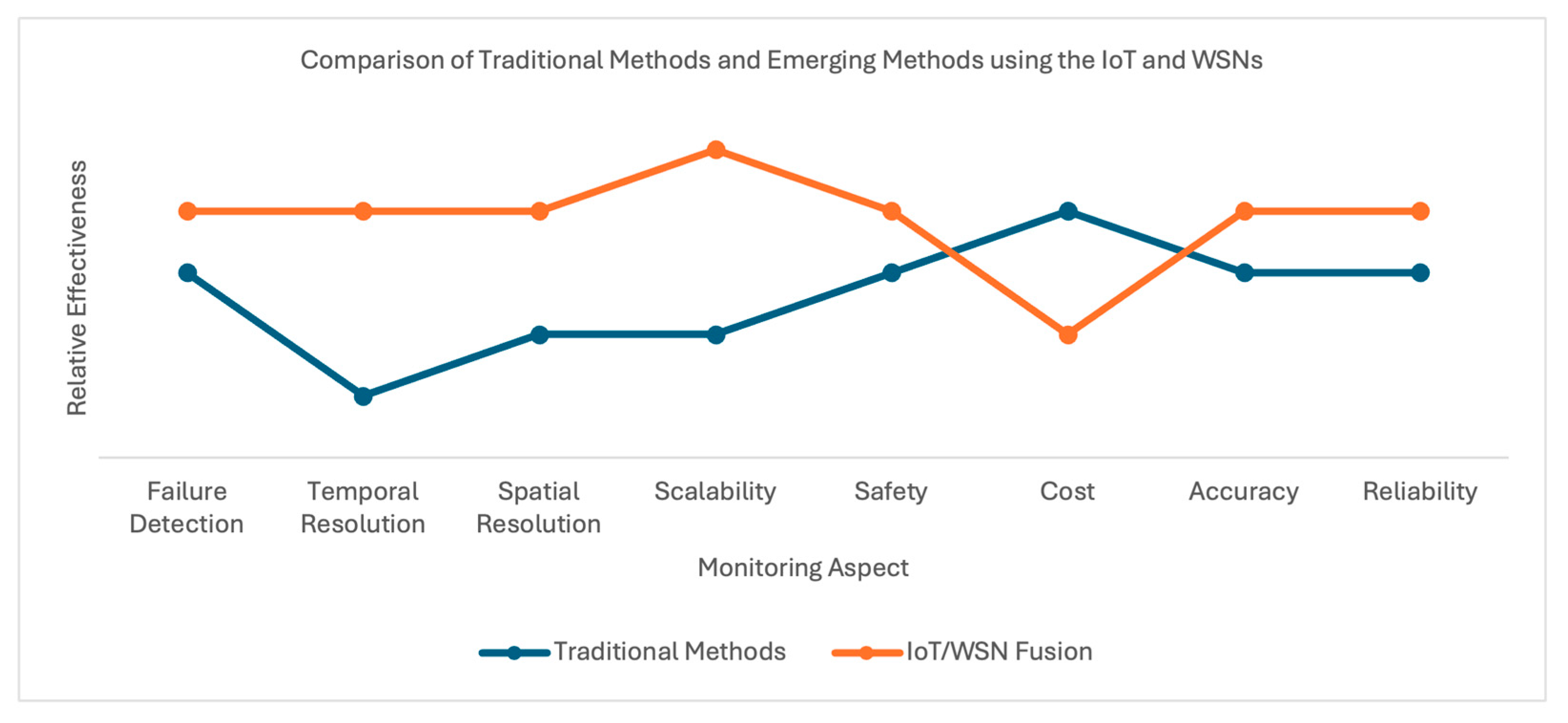
4.2.2. Integrated Monitoring Using the IoT and WSNs

The integration of the IoT and WSNs into geotechnical monitoring systems augments the scalability, flexibility, and responsiveness of traditional monitoring approaches. By deploying low-power wireless sensor nodes that capture and transmit physical data, such as stress, strain, or pressure, to cloud-based platforms, these systems enable real-time data acquisition, automated processing, and centralized data management [59], essentially providing iterative benefits to in situ solutions. This distributed networking architecture allows for broad spatial coverage and supports continuous monitoring across expansive and often hazardous environments, as demonstrated in [48,50,52].
Unlike conventional monitoring methods, which often face trade-offs between temporal resolution, spatial coverage, operational safety, and cost, as discussed throughout Section 4.1, the fusion of the IoT and WSNs presents a comprehensive framework, with minimal compromises. As shown in Figure 16, this approach excels across all key performance attributes in that it is scalable, cost effective, accurate, and supports continuous remote monitoring.
Furthermore, the integration of AI and edge computing within IoT frameworks enables real-time failure detection, advanced predictive analytics, and early risk mitigation strategies, enhancing both operational safety and decision making. This synergy allows for proactive slope management that can outperform traditional systems in terms of both responsiveness and precision [59].
The two primary limitations of IoT and WSN adoption within large-scale mining operations are associated with the inherent, underlying restrictions of the respective technologies. The remote nature of wireless sensor nodes presents power consumption challenges, and the lack of protocol standardization across IoT networks introduces data security and interoperability issues [52,59]. Despite these constraints, it is clear that the fusion of the IoT and WSNs serves as a transformative and complementary advancement in the field of open-pit slope stability monitoring.

4.3. Future Research Directions

In light of these findings, Table 15 presents a comprehensive evaluation of all the open-pit slope stability monitoring methods discussed in this review, collectively contrasting their strengths and weaknesses to identify potential gaps for future research. Accordingly, the following discussion focuses on these gaps, distilling them into clear, structured, future research directions.

4.3.1. Suggestion: Improve Monitoring Accuracy

Slope monitoring accuracy is a significant driver of effective operational safety in open-pit mining [1,2,3,4]. While most methods perform well in regard to capturing even the most minute slope displacements, notable limitations impact image-based techniques, such as digital photogrammetry and computer vision, particularly in challenging environmental conditions, postulating the need for further investigation.
The efficacy of digital photogrammetry is constrained by two predominant gaps, as highlighted by [26,27,47], namely: reduced effectiveness in shaded or heavily vegetated areas, and reduced DEM accuracy due to data interpolation. To address the first gap, HDR imaging technologies should be explored for open-pit mining applications, as they have demonstrated improved shadow detail preservation in other domains, including agriculture [61]. Regarding DEM accuracy, the integration of multi-sensor data extracted from in situ sources can be used to further enhance output precision, as evidenced by [62], while deep learning methods can be explored to mitigate interpolation artifacts and improve DEM fidelity [63].
Similarly, computer vision-based image analysis is also impacted by two principal limitations, in that its hazard detection accuracy is reduced in complex environments, and its object recognition capabilities are dependent on rigorously trained ML models that use high-quality datasets [46,54]. To address these issues, other ML models or algorithms should be explored, as analogous studies have demonstrated the effectiveness of various model optimization techniques in enhancing object detection accuracy, particularly in domains such as complex industrial construction environments [64]. Furthermore, the difficulty associated with obtaining high-quality datasets for ML model training may be circumvented by exploring the applicability of GenAI for producing synthetic datasets [65], particularly in the context of hazardous open-pit mines, where accessibility might be limited.

4.3.2. Suggestion: Enhance Spatial Coverage

Comprehensive spatial coverage is essential for providing holistic insights into overall slope stability, given the particularly complex geomechanics of vast open pits [54].
In situ methods, fundamentally, face limitations in this regard due to their point-based, localized nature [4,48,49,52,53,56]. In contrast, remote sensing techniques typically excel in this regard as they offer a superior LoS [19,21,32], with the exception of image-based approaches, such as digital photogrammetry and computer vision [26,46], which are tempered due to their underlying data collection methodologies. To overcome the spatial limitations inherent to in situ techniques, such as TDR, extensometers, inclinometers, and piezometers, future research efforts should investigate the retrofitting of traditional in situ monitoring frameworks with WSN capabilities and distributed sensor nodes, as described by [48,50,59], to achieve increased spatial granularity, while also facilitating real-time, autonomous data collection.
The spatial performance of image-based remote sensing methods can be enhanced by leveraging context-aware sensing frameworks, guided by key geotechnical parameters. Specifically, incorporating ground control elements, such as TARPs and RMC criteria, into deployment and data interpretation strategies [66] for autonomous UAVs could optimize monitoring frequency, thereby improving spatial coverage in high-risk areas. These context-aware sensing frameworks, which have been shown to greatly enhance the efficacy of computer vision-based image analysis in other domains [67,68], would allow monitoring systems to adapt dynamically to geotechnical risk profiles, enhancing overall slope coverage and maximizing monitoring efficiency.

4.3.3. Suggestion: Improve Temporal Resolution and Real-Time Monitoring

The effectiveness of any slope stability monitoring method is largely determined by its ability to provide advanced notice of incipient slope failure. Accordingly, temporal resolution, defined by the frequency of data acquisition, is a key performance metric, as systems capable of continuous or near real-time monitoring enable more proactive risk mitigation and timely intervention [1,4,54]. Despite this, popular remote sensing methods, such as satellite-based radar and digital photogrammetry [20,23,24,26,28,34,35,36,42,43], as well as emerging technologies, such as computer vision-based image analysis [46], provide unsatisfactory performance across this criterion, necessitating the requirement for further research.
The periodic and infrequent nature of SAR acquisitions is a limiting factor for both D-InSAR and PS-InSAR, restricting its ability to function effectively in volatile and evolving landscapes, such as open-pit mines [33,36]. For this reason, future research should explore the development of context-aware monitoring frameworks that integrate geotechnical parameters, such as slope angle, excavation rates, and ground control elements, to dynamically prioritize monitoring frequency and sensor deployment. These frameworks could enhance the temporal resolution through coordinated, integrated sensing strategies that complement satellite observations with ground-based sensors or UAV-based monitoring during satellite pass intervals.
The temporal resolution of digital photogrammetry is principally constrained by the high computational demands of data processing, particularly for 3D models and point cloud generation [26,45]. This issue is further compounded when coupled with ML-based computer vision techniques [46,54], which typically require significant Graphics Processing Unit (GPU) resources. However, advancements in edge computing have demonstrated the feasibility of performing such computationally intensive tasks in near real time, as shown in analogous domains like powerline inspection [69]. Similarly, recent studies in autonomous UAV navigation and mapping [70] have highlighted the benefits of offloading processing tasks to edge nodes to significantly improve responsiveness and data throughput.
To overcome the temporal limitations associated with conventional computer vision models, future research should investigate more efficient algorithms, such as YOLO, or lightweight, bespoke models designed for resource-constrained environments. When deployed in conjunction with edge AI on UAV platforms, these solutions could facilitate real-time hazard detection and adaptive monitoring in critical areas. This integrated approach has shown promise in comparable applications, such as autonomous road object detection on mine haul ramps, and presents a viable path toward improving the temporal resolution in open-pit slope stability monitoring systems [71].

4.3.4. Suggestion: Address Environmental Limitations

Environmental conditions, such as adverse weather, can significantly impact the reliability and effectiveness of remote sensing and in situ slope monitoring technologies.
This trend is most evident across remote sensing methods, particularly those reliant on optical and radar imaging, wherein the results indicated that the impacts of dust, rain, and cloud cover could lead to signal attenuation and degraded image quality [11,12,14,27,28,37,47]. For this reason, future research should investigate the suitability of redundant monitoring frameworks that leverage complementary sensor technologies capable of operating under varying environmental conditions. Such redundancy, in tandem with context-aware sensing, would ensure continuity in data acquisition during weather-induced disruptions, by, potentially, combining radar-based systems with rugged in situ sensors, thereby offering auxiliary monitoring to augment the overall reliability of the mine’s monitoring efforts.
While in situ monitoring systems, such as extensometers, inclinometers, and piezometers are inherently designed to operate under extreme conditions, they are, nonetheless, susceptible to degradation over time, leading to issues such as sensor drift and damage [72]. For this reason, to improve system durability, future research should investigate fiber optic technologies, which are resistant to EMI and environmental degradation, as demonstrated in analogous contexts, such as landslide monitoring [73].

4.3.5. Suggestion: Improve Economic Viability and Scalability

High equipment and ongoing maintenance costs pose significant limitations for various slope stability monitoring methods. Remote sensing technologies, including ground-based radar, thermal imaging, and laser scanning, along with in situ tools, such as TDR, extensometers, piezometers, and inclinometers, typically require substantial initial capital investment, are labor intensive to install and operate, and demand long-term maintenance, especially at scale [24,26,55,58,59]. To address these financial barriers, future research should explore the viability of low-cost, modular sensors, such as those discussed in Section 3.3.4. Despite the preliminary nature of these studies, advanced sensors like IMUs have been shown to provide a promising, cost-effective alternative to traditional in situ methods, due to their capacity to maintain acceptable accuracy and reliability [59]. For this reason, similar technologies should be examined for their applicability to open-pit slope stability monitoring.
Aside from equipment costs, the challenge of scaling these methods across large, geotechnically complex mine sites remains a significant gap in the research. This limitation is most evident in regard to in situ methods, which are inherently localized and require substantial infrastructure [55,58,59]. When implemented over extensive areas, the cumulative costs of installation and maintenance can rise quickly, hindering their feasibility for broad deployment across vast slope regions. To address this issue, future research should explore the use of IoT-enabled WSNs, as mentioned in Section 3.5.2, utilizing low-power sensor nodes and long-range, efficient networking protocols like LoRa. Their successful implementation in fields such as landslide monitoring and environmental hazard detection [74,75] showcases their potential to facilitate cost-effective, large-scale deployments in open-pit mining.

4.4. Limitations of This Review

While this systematic review followed a structured research methodology and presented a comprehensive analysis of prominent open-pit slope stability monitoring methods, it is evident that there is a noticeable bias toward certain technologies, particularly remote sensing methods, such as satellite-based radar and UAV-borne sensing. This trend likely reflects a topical bias within the available body of the literature, which may overrepresent novel approaches, potentially skewing the review’s results. As a result, more traditional methods using in situ sensors, such as piezometers, inclinometers, and extensometers, may appear elusive and antiquated. Although this does not constitute a methodological flaw in the review itself, it introduces a research focus bias that may influence comparative assessments between traditional and emerging methods. More broadly, this limitation clearly delineates the lack of contemporary research covering in situ methods, once more supporting this review’s recommendations regarding the integration of the IoT and WSN technologies into traditional slope monitoring frameworks.
We also acknowledge that the inaccessibility of several studies during the full-text screening stage may have introduced a risk of selection bias, despite extensive efforts to obtain these articles. However, we believe that the thematic analysis of the included studies reflects consistent patterns and key findings across a diverse range of sources, suggesting that the overall trends identified in this review are robust. While we cannot entirely rule out the potential for bias, we do not expect that the exclusion of these inaccessible studies would significantly alter the conclusions drawn in this review.
Another limitation of this review lies in its exclusive focus on slope stability monitoring methods, deliberately excluding studies related to slope design, modeling, and stability analysis. In addition to this, our review does not consider health and safety aspects associated with asset tracking and monitoring. While this scoping decision allowed for analytical depth, it also constrained the breadth of the findings, particularly regarding integrated risk management practices. This limitation is especially relevant in the context of Section 4.3.2 and Section 4.3.3, which explore opportunities for context-aware sensing and real-time hazard detection, both of which benefit from holistic integration with geotechnical design and modeling data.
In addition, this review concentrated solely on monitoring applications within the context of open-pit mining, excluding analogous domains such as TSFs, embankments, and landslides. Although this focus was intended to ensure contextual relevance, it may have led to the exclusion of valuable insights, given that these applications often employ similar instrumentation, sensors, and monitoring approaches.
Lastly, several of the emerging methods identified, such as AI-based computer vision and IoT-enabled WSNs, are still in the nascent stages of application to open-pit mining. Consequently, their validation is often limited to controlled or simulated laboratory environments, which creates a significant data gap concerning their large-scale deployment, reliability, and long-term effectiveness.

5. Conclusions

This systematic review has examined, analyzed, and summarized 49 studies on slope stability monitoring methods in open-pit mining, comparing remote sensing and in situ technologies, while identifying emerging trends, such as AI-driven computer vision and IoT-enabled WSNs.
The findings reveal that remote sensing technologies constitute the bulk of contemporary research, focusing on advanced modalities like InSAR and LiDAR, while exploring the use of UAVs to generate DEMs, using digital photogrammetry techniques. These methods are broadly accurate, precise, and effective at detecting and monitoring indicators of incipient slope failure, namely, geological displacement and visual signals like scarping, raveling, and cracking. In situ methods, conversely, are far less common in state-of-the-art literature. Despite this, the review results indicate that reliable geotechnical instruments, like TDR, extensometers, piezometers, and inclinometers, are unanimously praised for their effectiveness in tracking and quantifying sub-surface slope displacement trends, despite their rudimentary operating principles and methodologies. Emerging technologies, such as AI, ML, the IoT, and WSNs, act as a mediator between the old and the new, providing enhanced predictive monitoring capabilities and continuous real-time stability monitoring.
Through comparative analyses, the findings suggest that no single method is universally optimal, as each exhibits trade-offs between key performance attributes, such as measurement accuracy, spatial coverage, temporal resolution, operational complexity, and cost. While traditional methods, such as remote sensing and in situ monitoring, remain highly effective in certain domains, their limitations, particularly in regard to scalability, automation, and adaptability, underscore the value of integrating emerging technologies.
Further to this, the review also identified several prominent research gaps, particularly in the areas of real-time monitoring, economic viability, and adaptability to complex geotechnical and environmental conditions. These limitations served as the basis for the stipulation of a detailed set of future research directions, focused on improving accuracy through sensor fusion, enhancing spatial and temporal coverage via distributed sensor networks built on ground control elements, and reducing operational constraints through the use of modular, low-cost equipment.
Overall, the findings of this review highlight that the future of open-pit slope stability monitoring lies in the implementation of hybrid frameworks, leveraging the strengths of both traditional and emerging technologies, such as AI. By pursuing interdisciplinary research across geotechnical and electrical engineering and data science, the mining industry can push towards smarter, safer, and more efficient slope stability monitoring solutions, to ensure that every mine worker goes home safely after their shift.

Author Contributions

Conceptualization, R.L.R., M.S., S.K., and I.M.; methodology, R.L.R., M.S., S.K., and I.M.; writing—original draft preparation, R.L.R.; writing—review and editing, R.L.R., M.S., S.K., and I.M.; visualization, R.L.R.; supervision, M.S., S.K. and I.M. All authors have read and agreed to the published version of the manuscript.

Funding

This research received no external funding.

Data Availability Statement

The review protocol and quality assessment documentation is available upon request from the corresponding author.

Conflicts of Interest

The authors declare that there are no conflicts of interest.

References

  1. Geotechnical Considerations in Open Pit Mines. Available online: https://www.worksafe.wa.gov.au/publications/geotechnical-considerations-open-pit-mines-guideline (accessed on 26 February 2025).
  2. Mines Safety Bulletin, No. 171 Pit Wall Failure Management. Available online: https://www.worksafe.wa.gov.au/publications/mines-safety-bulletin-no-171-pit-wall-failure-management (accessed on 26 February 2025).
  3. Narendranathan, S.; Nikraz, H. Optimal System Design for Instrumented Slope Monitoring in Open Pit Mines. In Proceedings of the International Conference on Advances in Geotechnical Engineering (ICAGE 2011), Perth, Australia, 7–9 November 2011. [Google Scholar]
  4. Mohammed, M.M. A Review on Slope Monitoring and Application Methods in Open Pit Mining Activities. Int. J. Sci. Technol. Res. 2021, 10, 181–186. [Google Scholar]
  5. Raghuvanshi, T.K. Governing factors influence on rock slope stability—Statistical analysis for plane mode of failure. J. King Saud Univ. Sci. 2019, 31, 1254–1263. [Google Scholar] [CrossRef]
  6. Singh, B.; Goel, R.K. Chapter 17–Types of Failures of Rock and Soil Slopes. In Engineering Rock Mass Classification, 1st ed.; Singh, B., Goel, R.K., Eds.; Elsevier: Boston, MA, USA, 2011; pp. 211–230. [Google Scholar]
  7. Mohtarami, E.; Jafari, A.; Amini, M. Stability analysis of slopes against combined circular–toppling failure. Int. J. Rock Mech. Min. Sci. 2014, 67, 43–56. [Google Scholar] [CrossRef]
  8. Bobet, A. Analytical solutions for toppling failure. Int. J. Rock Mech. Min. Sci. 1999, 36, 971–980. [Google Scholar] [CrossRef]
  9. Carrera-Rivera, A.; Ochoa, W.; Larrinaga, F.; Lasa, G. How-to conduct a systematic literature review: A quick guide for computer science research. MethodsX 2022, 9, 101895. [Google Scholar] [CrossRef]
  10. Kmet, L.; Lee, R. Standard Quality Assessment Criteria for Evaluating Primary Research Papers from a Variety of Fields. HTA Initiat. 2024. [Google Scholar] [CrossRef]
  11. Agliardi, F.; Crosta, G.B.; Meloni, F.; Valle, C.; Rivolta, C. Structurally-controlled instability, damage and slope failure in a porphyry rock mass. Tectonophysics 2013, 605, 34–47. [Google Scholar] [CrossRef]
  12. Monserrat, O.; Crosetto, M.; Luzi, G. A review of ground-based SAR interferometry for deformation measurement. ISPRS J. Photogramm. Remote Sens. 2014, 93, 40–48. [Google Scholar] [CrossRef]
  13. Mecatti, D.; Macaluso, G.; Barucci, A.; Noferini, L.; Pieraccini, M.; Atzeni, C. Monitoring open-pit quarries by interferometric radar for safety purposes. In Proceedings of the 7th European Radar Conference (EURAD 2010), Paris, France, 30 September 2010. [Google Scholar]
  14. Francioni, M.; Salvini, R.; Stead, D.; Giovannini, R.; Riccucci, S.; Vanneschi, C.; Gullì, D. An integrated remote sensing-GIS approach for the analysis of an open pit in the Carrara marble district, Italy: Slope stability assessment through kinematic and numerical methods. Comput. Geotech. 2015, 67, 46–63. [Google Scholar] [CrossRef]
  15. Wang, J.; Gao, J.; Liu, C.; Wang, J. High precision slope deformation monitoring model based on the GPS/Pseudolites technology in open-pit mine. Min. Sci. Technol. 2010, 20, 126–132. [Google Scholar] [CrossRef]
  16. Francioni, M.; Salvini, R.; Stead, D.; Litrico, S. A case study integrating remote sensing and distinct element analysis to quarry slope stability assessment in the Monte Altissimo area, Italy. Eng. Geol. 2014, 183, 290–302. [Google Scholar] [CrossRef]
  17. Kromer, R.A.; Hutchinson, D.J.; Lato, M.J.; Gauthier, D.; Edwards, T. Identifying rock slope failure precursors using LiDAR for transportation corridor hazard management. Eng. Geol. 2015, 195, 93–103. [Google Scholar] [CrossRef]
  18. Liu, B.; Ge, D.; Li, M.; Zhang, L.; Wang, Y.; Zhang, X. Using GB-SAR technique to monitor displacement of open pit slope. In Proceedings of the 2016 IEEE International Geoscience and Remote Sensing Symposium (IGARSS), Beijing, China, 10–15 July 2016; pp. 5986–5989. [Google Scholar] [CrossRef]
  19. Qi, Y.; Zhang, M.; Qi, L.; Tan, W.; Sun, J.; Huang, P.; Xu, W. Application of Ground-based Deformation Monitoring Radar in Mine Slope Monitoring-Taking a mine in Inner Mongolia as an example. In Proceedings of the 2019 IEEE International Conference on Signal, Information and Data Processing (ICSIDP), Chongqing, China, 11–13 December 2019; pp. 1–4. [Google Scholar] [CrossRef]
  20. Wei, L.; Liu, S.; Mao, Y.; Wang, R.; Wu, L.; Xu, J. Joint application of DInSAR and ground measurements: A case study on dump stability analysis. In Proceedings of the 2016 IEEE International Geoscience and Remote Sensing Symposium (IGARSS), Beijing, China, 10–15 July 2016; pp. 6002–6005. [Google Scholar] [CrossRef]
  21. Dick, G.J.; Eberhardt, E.; Cabrejo-Liévano, A.G.; Stead, D.; Rose, N.D. Development of an early-warning time-of-failure analysis methodology for open-pit mine slopes utilizing ground-based slope stability radar monitoring data. Can. Geotech. J. 2014, 52, 515–529. [Google Scholar] [CrossRef]
  22. Farina, P.; Coli, N.; Yön, R.; Eken, G.; Ketizmen, H. Efficient real time stability monitoring of mine walls: The çöllolar mine case study. Int. Mining Congr. Exhib. Turkey 2013, 1, 111–117. [Google Scholar]
  23. Tripolitsiotis, A.; Steiakakis, C.; Papadaki, E.; Agioutantis, Z.; Mertikas, S.; Partsinevelos, P. Complementing geotechnical slope stability and land movement analysis using satellite DInSAR. Open Geosci. 2014, 6, 56–66. [Google Scholar] [CrossRef]
  24. Deguchi, T.; Sugiyama, T.; Kishimoto, M. R&D of Drone-Borne Sar System. ISPRS Int. Arch. Photogramm. Remote. Sens. Spat. Inf. Sci. 2019, XLII-2/W13, 263–267. [Google Scholar] [CrossRef]
  25. Intrieri, E.; Carlà, T.; Farina, P.; Bardi, F.; Ketizmen, H.; Casagli, N. Satellite Interferometry as a Tool for Early Warning and Aiding Decision Making in an Open-Pit Mine. IEEE J. Sel. Top. Appl. Earth Obs. Remote Sens. 2019, 12, 5248–5258. [Google Scholar] [CrossRef]
  26. Bar, N.; Kostadinovski, M.; Tucker, M.; Byng, G.; Rachmatullah, R.; Maldonado, A.; Pötsch, M.; Gaich, A.; McQuillan, A.; Yacoub, T. Pit Slope Failure Evaluation in Near Real Time using UAV Photogrammetry and 3D Limit Equilibrium Analysis. Aust. Geomech. J. 2020, 55, 33–47. [Google Scholar]
  27. Li, J.; Yang, T.; Deng, W.; Du, S.; Zhang, Z.; Ma, H.; Wang, H.; Guo, J.; Liu, L. Evaluating failure mechanisms of excavation-induced large-scale landslides in Xinjing open-pit coal mine through integrated UAV imagery and 3D simulation. Landslides 2025, 22, 2021–2036. [Google Scholar] [CrossRef]
  28. Lu, Y.; Jin, C.; Wang, Q.; Han, T.; Li, G.; Zhong, X.; Chen, G. Combining InSAR and infrared thermography with numerical simulation to identify the unstable slope of open-pit: Qidashan case study, China. Landslides 2023, 20, 1961–1974. [Google Scholar] [CrossRef]
  29. Lee, H.; Moon, J.; Lee, H. Activity of Okgye Limestone Mine in South Korea Observed by InSAR Coherence and PSInSAR Techniques. Remote Sens. 2022, 14, 6261. [Google Scholar] [CrossRef]
  30. Haupt, S.; Engelbrecht, J.; Sibolla, B.; Mdakane, L.W. Time Series Insar Analysis for Slope Stability Monitoring Using Sentinel-1 in Open Pit Mining. ISPRS Int. Arch. Photogramm. Remote. Sens. Spat. Inf. Sci. 2023, XLVIII-1/W, 945–951. [Google Scholar] [CrossRef]
  31. Chand, K.; Mankar, A.K.; Koner, R.; Naresh, A.R.V.S. Dump slope change detection and displacement monitoring using UAV close-range photogrammetry. Sādhanā 2024, 49, 277. [Google Scholar] [CrossRef]
  32. Hu, H.; Fernandez-Steeger, T.M.; Dong, M.; Azzam, R. Deformation Monitoring and Recognition of Surface Mine Slope Using LiDAR. In Engineering Geology for Society and Territory—Volume 2; Lollino, G., Giordan, D., Crosta, G.B., Corominas, J., Azzam, R., Wasowski, J., Sciarra, N., Eds.; Springer International Publishing: Berlin/Heidelberg, Germany, 2015; pp. 451–454. [Google Scholar]
  33. Hartwig, M.E.; Paradella, W.R.; Mura, J.C. Detection and Monitoring of Surface Motions in Active Open Pit Iron Mine in the Amazon Region, Using Persistent Scatterer Interferometry with TerraSAR-X Satellite Data. Remote Sens. 2013, 5, 4719–4734. [Google Scholar] [CrossRef]
  34. Paradella, W.R.; Mura, J.C.; Gama, F.F.; Santos, A.R.; Silva, G.G.; Galo, M.; Camargo, P.O.; Silva, A.Q. Complementary Use of Information from Space-Based Dinsar and Field Measuring Systems for Operational Monitoring Purposes in Open Pit Iron Mines of Carajás Mining Complex (Brazilian Amazon Region). ISPRS Int. Arch. Photogramm. Remote. Sens. Spat. Inf. Sci. 2015, XL-7/W3, 905–911. [Google Scholar] [CrossRef]
  35. Hartwig, M.E. Detection of mine slope motions in Brazil as revealed by satellite radar interferograms. Bull. Eng. Geol. Environ. 2016, 75, 605–621. [Google Scholar] [CrossRef]
  36. Carlà, T.; Intrieri, E.; Raspini, F.; Bardi, F.; Farina, P.; Ferretti, A.; Colombo, D.; Novali, F.; Casagli, N. Perspectives on the prediction of catastrophic slope failures from satellite InSAR. Sci. Rep. 2019, 9, 14137. [Google Scholar] [CrossRef]
  37. Bazarnik, M. Slope stability monitoring in open pit mines using 3D terrestrial laser scanning. E3S Web Conf. 2018, 66, 01020. [Google Scholar] [CrossRef]
  38. Fornós, J.R.I.; Sánchez, C. The use of InSAR for monitoring slope stability of rock masses. In Proceedings of the ISRM 1st International Conference on Advances in Rock Mechanics—TuniRock 2018, Hammamet, Tunisia, 29 March 2018. [Google Scholar]
  39. Preston, R.P. Implementation of a Pit Slope-Monitoring Network for Inactive Open-Pit Mines Using Photogrammetry. Rock Mech. Rock Eng. 2021, 54, 3377–3385. [Google Scholar] [CrossRef]
  40. He, Y.; Chen, S.; Zhang, B.; Chen, K. Multimedia Tilt Photography-Assisted Remote Sensing Technology in Mine Ecological Restoration. Comput. Intell. Neurosci. 2022, 1, 1442738. [Google Scholar] [CrossRef]
  41. Zhao, Y.; Wang, S.; Liu, S.; Yang, J. Real time light-independent slope-failure monitoring using LiDAR and 2D-3D semantic segmentation. In Proceedings of the 2022 IEEE Sensors, Dallas, TX, USA, 30 October–2 November 2022; pp. 1–4. [Google Scholar] [CrossRef]
  42. Tang, W.; Motagh, M.; Zhan, W. Monitoring active open-pit mine stability in the Rhenish coalfields of Germany using a coherence-based SBAS method. Int. J. Appl. Earth Obs. Geoinf. 2020, 93, 102217. [Google Scholar] [CrossRef]
  43. Bar, N.; Dixon, R. Unveiling unknowns: Practical application of InSAR for slope performance monitoring and risk management across multiple surface mines. Eng. Geol. 2021, 293, 106326. [Google Scholar] [CrossRef]
  44. Bar, N.; Kostadinovski, M.; Tucker, M.; Byng, G.; Rachmatullah, R.; Maldonado, A.; Pötsch, M.; Gaich, A.; McQuillan, A.; Yacoub, T. Rapid and robust slope failure appraisal using aerial photogrammetry and 3D slope stability models. Int. J. Min. Sci. Technol. 2020, 30, 651–658. [Google Scholar] [CrossRef]
  45. Coccia, S.; Marwan, A.; Klein, E. Combination of UAV-Borne Lidar and UAV-Borne Photogrammetry to Assess Slope Stability. In Proceedings of the 7th World Congress on Civil, Structural, and Environmental Engineering (CSEE’22), Lisbon, Portugal, 10–12 April 2022. [Google Scholar]
  46. Winkelmaier, G.; Battulwar, R.; Khoshdeli, M.; Valencia, J.; Sattarvand, J.; Parvin, B. Topographically Guided UAV for Identifying Tension Cracks Using Image-Based Analytics in Open-Pit Mines. IEEE Trans. Ind. Electron. 2021, 68, 5415–5424. [Google Scholar] [CrossRef]
  47. Mankar, A.K.; Koner, R. Drone Technology and 3D Reconstruction Approach for Efficient Management of Mine Dump Slope. In Sustainable and Innovative Mining Practices; Gorai, A.K., Ram, S., Bishwal, R.M., Bhowmik, S., Eds.; Springer Nature: Cham, Switzerland, 2025; pp. 586–595. [Google Scholar]
  48. Yadav, D.K.; Karthik, G.; Jayanthu, S.; Das, S.K. Design of Real-Time Slope Monitoring System Using Time-Domain Reflectometry with Wireless Sensor Network. IEEE Sensors Lett. 2019, 3, 2500304. [Google Scholar] [CrossRef]
  49. Yang, B.; Aminossadati, S.M.; Chen, Z.; Kizil, M.S. Fibre Optic Sensing Based Slope Crest Tension Crack Monitoring System for Surface Mines. In Proceedings of the 2nd International Conference for Fibre-optic and Photonic Sensors for Industrial and Safety Applications (OFSIS), Brisbane, QLD, Australia, 8–10 January 2017; pp. 27–32. [Google Scholar] [CrossRef]
  50. Yadav, D.K.; Mishra, P.; Jayanthu, S.; Das, S.K. Fog-IoT-Based Slope Monitoring (FIoTSM) System with LoRa Communication in Open-Cast Mine. IEEE Trans. Instrum. Meas. 2021, 70, 9514611. [Google Scholar] [CrossRef]
  51. Yadav, D.K.; Mishra, P.; Jayanthu, S.; Das, S.K. On the Application of IoT: Slope Monitoring System for Open-cast Mines Based on LoRa Wireless Communication. Arab. J. Sci. Eng. 2022, 47, 1387–1398. [Google Scholar] [CrossRef]
  52. Giri, P.; Ng, K.; Phillips, W. Monitoring toppling failures using wireless inertial measurement unit sensors. Geotech. Res. 2022, 9, 83–94. [Google Scholar] [CrossRef]
  53. Zhou, Y.; Li, Y.; Chen, Y. Remote Real-Time Monitoring System for Mine Slope Based on Cloud Computing. Water 2022, 14, 714. [Google Scholar] [CrossRef]
  54. Li, Q.; Song, D.; Yuan, C.; Nie, W. An image recognition method for the deformation area of open-pit rock slopes under variable rainfall. Measurement 2022, 188, 110544. [Google Scholar] [CrossRef]
  55. Kumar, A.; Villuri, V.G.K. Role of Mining Radar in Mine Slope Stability Monitoring at Open Cast Mines. Procedia Earth Planet. Sci. 2015, 11, 76–83. [Google Scholar] [CrossRef]
  56. Vaziri, A.; Moore, L.; Ali, H. Monitoring systems for warning impending failures in slopes and open pit mines. Nat. Hazard. 2010, 55, 501–512. [Google Scholar] [CrossRef]
  57. Nunoo, S.; Tannant, D.D.; Newcomen, H.W. Slope monitoring practices at open pit porphyry mines in British Columbia, Canada. Int. J. Min. Reclam. Environ. 2016, 30, 245–256. [Google Scholar] [CrossRef]
  58. Osasan, K.S.; Afeni, T.B. Review of surface mine slope monitoring techniques. J. Min. Sci. 2010, 46, 177–186. [Google Scholar] [CrossRef]
  59. Yadav, D.K.; Jayanthu, S.; Das, S.K.; Chinara, S.; Mishra, P. Critical review on slope monitoring systems with a vision of unifying WSN and IoT. IET Wirel. Sens. Syst. 2019, 9, 167–180. [Google Scholar] [CrossRef]
  60. Beranek, L.L.; Mellow, T.J. Chapter 1—Introduction and terminology. In Acoustics: Sound Fields and Transducers; Beranek, L.L., Mellow, T.J., Eds.; Academic Press: Cambridge, MA, USA, 2012; pp. 1–19. [Google Scholar]
  61. Suh, H.K.; Hofstee, J.W.; van Henten, E.J. Improved vegetation segmentation with ground shadow removal using an HDR camera. Precis. Agric. 2018, 19, 218–237. [Google Scholar] [CrossRef]
  62. Schiewe, J. Integration of multi-sensor data for landscape modeling using a region-based approach. ISPRS J. Photogramm. Remote Sens. 2003, 57, 371–379. [Google Scholar] [CrossRef]
  63. Ruiz-Lendínez, J.J.; Ariza-López, F.J.; Reinoso-Gordo, J.F.; Ureña-Cámara, M.A.; Quesada-Real, F.J. Deep learning methods applied to digital elevation models: State of the art. Geocarto Int. 2023, 38, 2252389. [Google Scholar] [CrossRef]
  64. Cho, J.; Kim, K. Detection of moving objects in multi-complex environments using selective attention networks (SANet). Autom. Constr. 2023, 155, 105066. [Google Scholar] [CrossRef]
  65. Sengar, S.S.; Hasan, A.B.; Kumar, S.; Carroll, F. Generative artificial intelligence: A systematic review and applications. Multimed. Tools Appl. 2024, 67, 1–40. [Google Scholar] [CrossRef]
  66. Elmouttie, M.; Dean, P. Systems Engineering Approach to Slope Stability Monitoring in the Digital Mine. Resources 2020, 9, 42. [Google Scholar] [CrossRef]
  67. Wang, X.; Zhu, Z. Context understanding in computer vision: A survey. Comput. Vis. Image Underst. 2023, 229, 103646. [Google Scholar] [CrossRef]
  68. Mastouri, M.; Bouyahia, Z.; Haddad, H.; Horchani, L.; Jabeur, N. A Context-Aware, Computer-Vision-Based Approach for the Detection of Taxi Street-Hailing Scenes from Video Streams. Sensors 2023, 23, 4796. [Google Scholar] [CrossRef] [PubMed]
  69. Pu, S.; Xie, L.; Ji, M.; Zhao, Y.; Liu, W.; Wang, L.; Yang, F.; Qiu, D. Real-Time Powerline Corridor Inspection by Edge Computing of Uav Lidar Data. ISPRS Int. Arch. Photogramm. Remote. Sens. Spat. Inf. Sci. 2019, XLII-2/W13, 547–551. [Google Scholar] [CrossRef]
  70. Messous, M.A.; Hellwagner, H.; Senouci, S.M.; Emini, D.; Schnieders, D. Edge Computing for Visual Navigation and Mapping in a UAV Network. In Proceedings of the ICC 2020–2020 IEEE International Conference on Communications (ICC), Dublin, Ireland, 7–11 June 2020; pp. 1–6. [Google Scholar] [CrossRef]
  71. Xu, X.; Zhao, S.; Xu, C.; Wang, Z.; Zheng, Y.; Qian, X.; Bao, H. Intelligent Mining Road Object Detection Based on Multiscale Feature Fusion in Multi-UAV Networks. Drones 2023, 7, 250. [Google Scholar] [CrossRef]
  72. Saha, A.; Mi, Y.; Glassmaker, N.; Shakouri, A.; Alam, M.A. In Situ Drift Monitoring and Calibration of Field-Deployed Potentiometric Sensors Using Temperature Supervision. ACS Sens. 2023, 8, 2799–2808. [Google Scholar] [CrossRef] [PubMed]
  73. Zheng, Y.; Zhu, Z.; Li, W.; Gu, D.; Xiao, W. Experimental research on a novel optic fiber sensor based on OTDR for landslide monitoring. Measurement 2019, 148, 106926. [Google Scholar] [CrossRef]
  74. Wang, C.; Guo, W.; Yang, K.; Wang, X.; Meng, Q. Real-Time Monitoring System of Landslide Based on LoRa Architecture. Front. Earth Sci. 2022, 10, 899509. [Google Scholar] [CrossRef]
  75. Inbavalli, A.; Praveena, R.; Kaviya, M. Assessing Metrics using LoRa Technology for Real-Time Landslide Monitoring within an IoT Framework. In Proceedings of the 4th International Conference on Pervasive Computing and Social Networking (ICPCSN), Salem, India, 3–4 May 2024; pp. 656–662. [Google Scholar] [CrossRef]
Figure 1. Open-pit wall cross-sectional schematic diagram.
Mining 05 00032 g001
Figure 2. Slope failure mechanisms in action: plane failure (top left), wedge failure (top right), circular failure (bottom left), and toppling failure (bottom right).
Mining 05 00032 g002
Figure 3. Flowchart of study identification, screening, and selection, using the PRISMA 2020 guidelines.
Mining 05 00032 g003
Figure 4. Breakdown of study selection by searched databases.
Mining 05 00032 g004
Figure 5. Distribution of included studies based on year of publication.
Mining 05 00032 g005
Figure 6. Categories and methods of open-pit slope stability monitoring.
Mining 05 00032 g006
Figure 7. Data acquisition through D-InSAR, illustrating the phase difference between two SAR acquisitions at different satellite passes due to slope displacement.
Mining 05 00032 g007
Figure 8. Digital photogrammetry data acquisition.
Mining 05 00032 g008
Figure 9. GB-SAR equipment.
Mining 05 00032 g009
Figure 10. GPS differential positioning detecting circular slope failure.
Mining 05 00032 g010
Figure 11. TDR sensor within a slope borehole, detecting the presence of a failure plane by measuring the impedance change in the reflected signal (top right).
Mining 05 00032 g011
Figure 12. Traditional wireline extensometer detecting slope failure initiated by tensile crack formation.
Mining 05 00032 g012
Figure 13. Borehole inclinometer schematic.
Mining 05 00032 g013
Figure 14. Radar chart comparison between remote sensing and in situ monitoring methods for assessing open-pit slope stability.
Mining 05 00032 g014
Figure 15. Heatmap showing the real-time monitoring capabilities of slope stability monitoring methods.
Mining 05 00032 g015
Figure 16. Parallel coordinates plot showing the differences between traditional and emerging methods for open-pit slope stability monitoring.
Mining 05 00032 g016
Table 1. PICO criteria used for evaluating the effectiveness of open-pit slope stability monitoring methods.
PICO CriterionDescriptionValue
PopulationWhat is the topic?Open-pit mines
InterventionWhat is being examined?Slope stability monitoring
ComparisonWhat is the control group?N/A
OutcomeWhat is being measured?Accuracy and effectiveness
Table 2. Inclusion and exclusion criteria used in the study selection process.
CriteriaInclusionExclusion
RelevanceStudies on open-pit slope stability monitoring methods and technologiesStudies focused on underground mining or civil infrastructure, such as tailings storage facilities (TSFs) or embankments
Publication TypeJournal articles, conference papers, review papersGrey literature, textbooks, thesis papers
Publication DateStudies published after 2005Studies published prior to 2005
LanguageStudies published in EnglishStudies in languages other than English
Table 3. Database selection and rationalization.
DatabaseReason for Inclusion
IEEE XploreSpecializes in research covering advanced sensor and networking technologies, such as the IoT, WSNs, and AI
ScopusProvides a broad, multidisciplinary repository of mining engineering research
ScienceDirectPopular database focusing on the intersection of the applied sciences and engineering
ASCE LibraryContains a myriad of research on civil, structural, and mining engineering
Table 4. Keywords and synonyms used to derive the database search query.
KeywordSynonym
Open-pit mineSurface mine, open cast mine, open pit
Slope stabilityRock slope failure, mine slope deformation, slope failure
MonitoringDetection, prediction
Table 5. Database search query used in the study selection process.
(“open-pit mine” OR “surface mine” OR “open cast mine” OR “open pit”) AND (“slope stability” OR “rock slope failure” OR “mine slope deformation” OR “slope failure”) AND (“monitoring” OR “detection” OR “prediction”)
Table 6. Quality assessment criteria and scoresheet used to evaluate selected studies.
CriteriaYes (2 Points)Partial (1 Point)No (0 Points)
Study objective clarity
Study design appropriateness
Study results presented clearly
Study conclusion clear and relevant
Table 7. Categorization of included studies based on monitoring methods used.
CategoryMonitoring MethodStudies (n = 49)References
Remote SensingSatellite-Based Radar, Ground-Based Radar, Digital Photogrammetry, Laser Scanning, Geodetic Surveying, Thermal Imaging37[11,12,13,14,15,16,17,18,19,20,21,22,23,24,25,26,27,28,29,30,31,32,33,34,35,36,37,38,39,40,41,42,43,44,45,46,47]
In Situ MonitoringTime Domain Reflectometry, Extensometers, Piezometers, Advanced Sensors, Inclinometers12[48,49,50,51,52,53,54,55,56,57,58,59]
Table 8. List of remote sensing methods identified in the review.
Remote Sensing MethodReferences
Satellite-Based Radar[15,20,23,25,28,29,30,33,34,35,36,38,42,43]
Ground-Based Radar[11,12,13,18,19,21,22]
Digital Photogrammetry[16,24,26,27,31,39,40,44,45,46,47]
Laser Scanning[14,16,17,32,37,41]
Geodetic Surveying[14,15,20]
Thermal Imaging[28]
Table 9. Summary of remote sensing methods for open-pit slope stability monitoring.
MethodAccuracySpatial CoverageTemporal
Resolution
AdvantagesLimitations
Satellite-Based Radar1–10 mmVery LargeLow (Periodic)Wide-area monitoring, effective for long-term displacement analysis, with low infrastructure investmentLow temporal resolution due to data acquisition frequency, susceptible to atmospheric interference
Digital Photogrammetry1–10 cmModerateLowCost effective and flexible, suitable for rapid data collection and terrain modellingLimited measurement resolution, requires optimal ambient conditions
Ground-Based Radar<1 mmLargeReal timeVery high accuracy, continuous monitoringLimited operational flexibility, high cost
Laser Scanning<1 mmModerateNear real timeHigh precision, operationally flexibleLoS requirements, limited coverage, high cost
Geodetic Surveying1–10 mmLargeReal timeHigh accuracy, reliable for long-term displacement trackingLabor-intensive deployment, requires skilled operators
Thermal ImagingN/ALocalizedLowEffective for detecting surface anomalies to augment other methodsLow spatial resolution, influenced by surface emissivity
Table 10. List of in situ monitoring methods identified in this review.
In Situ Monitoring MethodReferences
Time Domain Reflectometry[48,50,51,55,57,58,59]
Extensometers[55,56,57,58,59]
Piezometers[54,57,58,59]
Advanced Sensors[49,52,53]
Inclinometers[56,57,58,59]
Table 12. Comparison of monitoring method categories for open-pit slope stability monitoring.
AspectRemote SensingIn Situ Monitoring
Measurement AccuracyGood (sub-mm to cm) 1Very high (<1 mm)
Spatial CoverageVariable (localized to large) 2Localized
Temporal ResolutionVariable (up to several weeks) 2Real-time or periodic 3
Monitoring DepthSurface-level displacements onlySurface and sub-surface
Installation ComplexitySimpleDifficult
Real-Time MonitoringMethod dependent 4Yes
Primary StrengthRemote data acquisitionReliability
Primary LimitationLimited temporal resolutionLimited spatial coverage
1 Remote sensing precision varies from sub-mm for GB-InSAR to cm level for UAV-borne photogrammetry (see Table 9). 2 Spatial coverage and temporal resolution are dependent on the underlying technologies used (see Table 9). 3 In situ monitoring frequency varies based on sensor type and deployment setup (see Table 11). 4 Some remote sensing methods are suitable for real-time monitoring, such as GB-InSAR, while others require extensive data post-processing, such as UAV-borne digital photogrammetry (see Table 9).
Table 13. List of emerging trends identified in this review.
Emerging TrendReferences
Artificial Intelligence and Machine Learning[46,54]
The IoT and Wireless Sensor Networks[48,50,52,59]
Table 14. Comparison of traditional and emerging methods for open-pit slope stability monitoring.
AspectTraditional MethodsEmerging Methods
Failure DetectionSoftware-assisted detection of direct and indirect failure indicators (e.g., displacement, strain)AI-driven detection of direct failure indicators (e.g., tensile cracks)
Data CollectionRanges from periodic, infrequent measurements to real-time monitoring, depending on the methodCapacity for continuous, real-time data acquisition enabled by edge computing and cloud-based processing
ScalabilityLimited scalability due to high equipment costs and fixed sensor installationHighly scalable, as the IoT and WSNs enable flexible, cost-effective deployment over vast areas
Operational SafetyRemote sensing minimizes personnel exposure, but in situ methods require maintenance in hazardous environmentsFully remote monitoring, reducing personnel risk, WSNs offer redundancy to enhance reliability
Cost and InfrastructureHigh initial investment and ongoing maintenance costsLower setup and operational costs due to automation and cloud-based storage
Accuracy and ResolutionHigh spatial resolution, but may have limited temporal resolution due to data acquisition intervalsAI improves detection speed and precision, although effectiveness is impacted by scene complexity
Reliability and ChallengesSusceptible to environmental interference, requires data post-processing and expert analysisAI requires large, high-quality datasets for ML model training, the IoT and WSNs depend on power-efficient networking and protocol standardization
Table 15. Gap analysis and future research directions.
AspectIdentified GapAffected MethodsFuture Research Direction
AccuracyReduced accuracy in shaded or vegetated terrainDigital PhotogrammetryInvestigate High Dynamic Range (HDR) technology for the capturing of enhanced shadow details
Reduced accuracy due to data interpolationEnhance DEM capabilities by augmenting with in situ sensor data
Reduced accuracy in regard to complex scenesArtificial Intelligence (Computer Vision)Investigate other ML models and sensor fusion
Requires solid datasets for ML model trainingInvestigate the efficacy of synthetic datasets using Generative AI (GenAI)
Spatial CoverageLimited slope coverageIn Situ MethodsInvestigate retrofitting in situ frameworks with WSN capabilities and distributed sensor nodes
Digital Photogrammetry, Artificial Intelligence (Computer Vision)
Temporal ResolutionPeriodic or infrequent data collectionSatellite-Based RadarInvestigate integrated sensing approaches using ground control elements (e.g., Trigger Action Response Plan (TARP) and Rock Mass Classification (RMC))
Delays due to data processingDigital Photogrammetry, Artificial Intelligence (Computer Vision)Investigate edge computing and edge AI for real-time data processing, and more efficient models, such as You Only Look Once (YOLO)
Operational ComplexitySpecialist data interpretationBoth Remote Sensing and In Situ MonitoringLeverage AI-powered data interpretation tools, such as computer vision
Real-Time MonitoringLack of continuous monitoring capabilitiesSatellite-Based RadarInvestigate integrated sensing to provide real-time monitoring during satellite ‘downtime’
Digital Photogrammetry, Artificial Intelligence (Computer Vision)Investigate integrated sensing using UAVs, in combination with WSNs and edge computing, to provide real-time hazard detection using ML models like YOLO
Environmental LimitationsSignal attenuation due to weather conditionsRemote Sensing MethodsInvestigate monitoring frameworks with redundancy to provide auxiliary monitoring during poor weather conditions
Sensor degradation due to extreme conditionsExtensometers, Inclinometers, PiezometersInvestigate rugged sensors
Economic ViabilityHigh equipment and maintenance costsGround-Based Radar, Thermal Imaging, Laser Scanning, TDR, Extensometers, Piezometers, InclinometersInvestigate the efficacy of low-cost, modular sensors, such as the advanced sensors discussed in Section 3.3.4
ScalabilityHigh cost and complexity limit large-scale deploymentGround-Based Radar, TDR, Extensometers, Piezometers, InclinometersInvestigate the applicability of IoT-enabled WSNs using low-power sensor nodes and networking technologies, such as LoRa
Disclaimer/Publisher’s Note: The statements, opinions and data contained in all publications are solely those of the individual author(s) and contributor(s) and not of MDPI and/or the editor(s). MDPI and/or the editor(s) disclaim responsibility for any injury to people or property resulting from any ideas, methods, instructions or products referred to in the content.

