Abstract
An overview of the meteorological and synoptic conditions for the formation of the severe drought which occurred in 2019–2020 in the southwest of Ukraine showed that the combination of several adverse factors influenced the evolution of the drought over a long period of time. Analysis of two types of drought indices and anomalies in the tropospheric pressure fields showed that the formation of a precipitation deficit began long before the occurrence of drought, due to the repetition of high pressure fields in the region, through which the intensity of the drought increased gradually.
1. Introduction
The territory of Eastern Europe is a region where droughts of different intensities and durations often occur. Southern regions in the warm period of the year are especially susceptible to drought when anticyclonic processes prevail in the atmosphere and contribute to intensive heating and drying of the air and soil due to lack of precipitation. Meteorological and agricultural droughts are widespread and can significantly reduce the yield of grain crops, especially if they occur in spring and summer. The drought of 2019–2020 in the Northern Black Sea region of Ukraine was caused by a long lack of precipitation and warm winter and was the strongest since 1947. It reduced the soil moisture available for crops and led to the damage of 80–100% of crops in the Odessa region in the spring of 2020. This drought had a catastrophic impact on the regional agricultural sector and led to a significant decrease in the export of grain crops.
Droughts are high impact hydrometeorological hazards, which require the improvement of monitoring and forecasting methodologies due to their increasing frequency in changing the climate of all regions of the Earth. The absence of a universal definition of drought and a variety of assessment methods are problematic when choosing the most effective methodology for regional monitoring. This fact leads to the adaption of existing methods and the development of new approaches that can take into account both the physical mechanism for the origin and evolution of drought and the influence of the geographical and climatic features of the study region.
Natural drought is defined as the deviation of meteorological, agricultural and hydrological parameters (for example, the amount of precipitation, soil moisture, river runoff, groundwater level, etc.) from climatic conditions. Meteorological (or atmospheric) drought is formed under conditions of precipitation deficit, under high temperatures and at low humidity, which are created due to the high level of insolation in the absence of clouds [1]. This combination of meteorological parameters leads, on the one hand, to an increase in evaporation and transpiration, and on the other hand to a decrease in runoff, infiltration and soil water supply. Meteorological droughts can quickly begin and end suddenly if an abundant amount of precipitation occurs. However, if there is no precipitation for a long period, the reserves of soil moisture are gradually depleted. Agricultural drought is often determined by the lack of water in the soil to support the growth of crops rather than the absence of normal precipitation for a certain period.
The purpose of this study is to undertake a comprehensive analysis of drought indicators and atmospheric processes, and thereby to identify the conditions for the formation of sever agricultural drought in the Odessa region, located at the southwest of Ukraine in the Northern Black Sea region.
2. Materials and Methods
Drought is characterized by severity, duration and distribution area. Drought monitoring is based on indicators and indices that evaluate changes in the hydrological cycle of the region. Indicators that are used to describe drought conditions are: precipitation, temperature, runoff, groundwater levels, reservoir levels, soil moisture and snow cover. The indices, on the other hand, are the calculated numerical parameters that describe the intensity of drought using climatic and/or current hydrometeorological data. Indices are provided by quantitative measurements, e.g., precipitation and air temperature that correspond to intensity, duration, place and time of drought. They are necessary for tracking and predicting the impact of drought, and can also form historic records to assess future droughts. Within the Drought Risk Reduction Framework and Practices [2], three basic drought monitoring methods are defined for evaluation and early warning:
- use of one indicator or index
- use of several indicators or indexes
- use of composite or hybrid indicators.
Historically, only one indicator or the index was used for tracking drought due to restrictions. Recently, hybrid or composite indicators combining various indicators or indexes have become more reliable in detecting drought. Composite indicators are more effective because the degree of drought severity is estimated using various water content data available in a particular region [3].
Composite drought indicators can combine the parameters obtained from data from both ground observations and satellite remote sensing. These indicators, as a rule, become the basis of drought monitoring systems.
In this study, the severe drought in the Northern Black Sea region was estimated using two indices: a meteorological drought index SPI (the Standardized Precipitation Index; on a 1 month time scale) based on ground observations of precipitation, and an index of anomalies of the satellite-derived index NDVI (Normalized Difference Vegetation Index). The first parameter characterizes the level of precipitation deficit relative to the norm, and the second index characterizes the degree of water stress on vegetation due to the impact of the drought conditions.
A grid dataset of SPI index (0.5 degree) was obtained from the IRI Analyses SPI: Standardized Precipitation Index analyses of multiple global precipitation datasets (http://iridl.ldeo.columbia.edu/SOURCES/.IRI/.Analyses/.SPI/, accessed on 19 March 2021) For any region, meteorological drought is indicated as SPI decreases below −1.0. To determine the intensity of drought, the following criteria of SPI are used [4]: −1.0, …, −1.49 is moderately dry; −1.5, …, −1.99 is severely dry; ≤−2.0 is extremely dry.
The time series of the SPI values were analyzed at the grid points closest to the 10 district centers of the Odessa region, which is the largest region of Ukraine (http://rada.com.ua/eng/regionspotential/odesa/, accessed on 2 May 2021) and which most suffered from drought. Since the area of Odessa region has a meridional orientation, the estimate was made for the northern and southern part of the region (Figure 1).
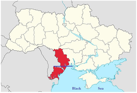
Figure 1.
Position of the Odessa region on the map of Ukraine, on which the blue line divides it conditionally on the northern and southern parts.
A monthly area average of 0.05 degree NDVI for the southern and northern part was taken from the Giovanni database (https://giovanni.gsfc.nasa.gov/giovanni/, accessed on 11 January 2021). Calculation of the monthly index of NDVI anomalies was done using the formula according to [5]:
where NDVIi is value at a particular moment in time; is long-term mean value; is standard deviation. Commonly, a value of NDVIA ≤−1 indicates a drought.
To assess the atmospheric conditions for the formation of a precipitation deficit and the occurrence of drought, the pressure fields at the sea surface level (SLP) and in the middle troposphere (500 hPa level) over the Northern Black Sea region were analyzed during the study period. Analysis and visualization of the results are based on the ERA5 reanalysis data using KNMI Climate Explorer (https://climexp.knmi.nl, accessed on 3 March 2021).
The blocking process in the region was estimated using the ECBI (European Continental Blocking Index), based on an assessment of the state of zonal flow at level 300 hPa [6]. This index is calculated using data of NCEP-NCAR reanalysis for the restricted area (10–60 E and 40–60 N) by the formula:
where is a current pentad value of the zonal component of wind at the level of 300 hPa averaged over the area; is a climatic value of the zonal component of wind at the same level averaged over the area (over the basic period of 1981–2010).
3. Results and Discussion
3.1. Time Course of the SPI
The analysis of the time course of the drought index SPI on a 1 month time scale showed that after relatively favorable spring months at the different points of the Odessa region, the deficit of precipitation (SPI < 0) was observed in almost all months of 2019 (except October), and continued into the first months of 2020 (except February). The lowest of the SPI values was observed in April 2020 (−1.88, …, −1.66), which corresponds to severe drought.
Analysis of the spatiotemporal distribution of the anomalies of satellite-derived vegetation index, NDVI, in March–October showed that in 2019, the positive anomalies were observed only in the spring months. However, since the beginning of summer until the middle of the autumn, an increase in the negative anomalies of the NDVI index was observed. March 2020 was characterized by favorable conditions for vegetation. However, in April, the anomalies of NDVI became negative and reached its lowest point in May (−1.87), which indicates a drought state. In the summer and autumn months, the negative anomalies of NDVI continued throughout the region, and the NDVI values did not exceed 0.47–0.53, which indicates the moderate stress of vegetation during the warm season.
According to the SPI index, in the southern part of the Odessa region, the periods of weak to moderate intensity drought were observed in February–March 2019, as well as from November 2019 to January 2020 (Figure 2a). From April to October 2019, the SPI values varied at about 0, which indicates that precipitation was within the norm. The level of precipitation was above the norm in February 2020, but in March, moderate drought was observed and in April drought reached a severe intensity (SPI values up to −1.88). The summer season of 2020 in the southern part of the Odessa region was characterized by the predominance of drought of different intensities, despite some improvement in the situation with precipitation in May 2020. In August, drought in all points reached the criterion of moderate intensity.
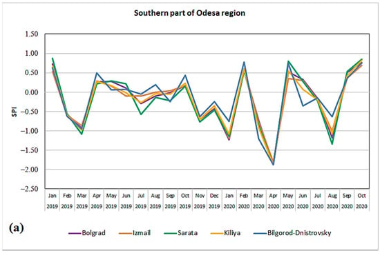
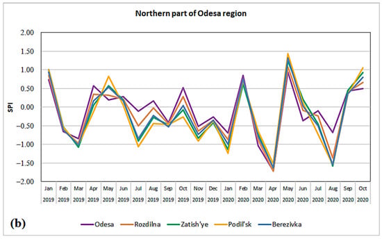
Figure 2.
Time course of monthly drought index SPI in the southern (a) and northern parts (b) of the Odessa region in January 2019–October 2020.
In the northern parts of the Odessa region (Figure 2b), the time course of the SPI index in 2019 is similar to the southern area, but in summer the weak drought prevailed, with the exception of the Odessa, and April–May was characterized by more favorable moisturizing conditions. As in the southern part, the strongest drought was observed in April 2020 (SPI = −1.71, …, −1.62). In the summer, the intensity of drought was higher than in the southern part, and severe drought was observed in August.
The analysis showed that in the cold seasons of 2019–2020 there was a continuous lack of precipitation, which was caused by the absence of southern (or Mediterranean) cyclones, which are the main source of precipitation and accumulation of soil moisture in the south of Ukraine in winter [7]. In addition, winter 2019–2020 was one of the warmest over the past decade. The air temperature in the Odessa region was 3–5 °C above average long-term values, and in February 5–6 °C above average long-term values. A steady transition to temperatures above 0 °C, that is, the beginning of spring, occurred at the end of January 2020 [8]. High winter temperatures and absence of snow cover led to an additional soil draining at the beginning of the growing season of 2020.
3.2. Time Course of the NDVIA
The analysis of the anomalies of the satellite vegetation index NDVIA in March–October 2019 showed that positive anomalies were observed only in the spring months, and the state of vegetation was better in the northern part of the Odessa region (Figure 3). However, from the beginning of the summer to the middle of the autumn, an increase in the negative anomalies was observed and in September–October, NDVIA values reached −1, which indicates a stress on vegetation, associated not only with the end of the growing season, but also dry conditions observed during the summer time. March 2020 was characterized by favorable vegetation conditions, but in April the NDVIA became negative and reached the minimum in May (−1.87) in the southern part of the Odessa region, which indicates a severe drought and strong stress on the plants. In the summer and autumn months, NDVIA negative values continued throughout the region, and the values of the vegetation index NDVI did not exceed 0.47–0.53, which indicates a moderate stress on vegetation during the entire warm season of 2020.
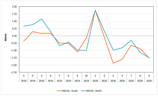
Figure 3.
Time series of monthly NDVIA, averaged over the southern and northern parts of the Odessa region, in March–October 2019 and March–September 2020.
3.3. Dynamics of the Regional Atmocpheric Processes
The formation of a long-term deficit of precipitation and a deficit of soil moisture content is usually a consequence of the long-term exposure of the atmospheric processes which are unfavorable to the formation of precipitation. Therefore, the tropospheric pressure fields over the Northern Black Sea region were analyzed, not only for period of 2019–2020, but over the past ten years, to see the dynamics of the development of atmospheric conditions that led to the severe drought.
The time course of the monthly anomalies of the SLP, averaged in the region of the study (Figure 4a) showed that frequency of occurrence of the positive and negative anomalies was about the same in the period from 2010 to 2020, but there were short periods (about two years) with a predominance of one or another anomaly. Thus, the positive SLP anomalies in the region were typical for 2011–2012 and 2015–2017, during which Ukraine experienced droughts of different intensities [9]. In the period from 2018 to 2020, the frequency of positive anomalies, in general, exceeded negative one, which may indicate the prevalence of anticyclonic processes preceding the drought case study.
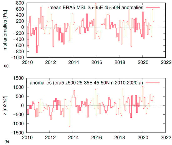
Figure 4.
Time series of the monthly anomalies of the SLP (a) and anomalies of the geopotential height H-500 (b), averaged over the Odessa region during period 2010–2020.
In the middle troposphere in the time course of the geopotential height H-500, there were three periods distinguished with the predominance of anomalies of various signs (Figure 4b). In the period from 2010 to 2013, negative anomalies H-500 prevailed, from 2014 to 2017 no predominance of any anomalies was observed. Since 2018, the average monthly positive anomalies of geopotential heights prevailed, and in the second half of 2019 and in January 2020 positive anomalies reached maximum values. Thus, in the period preceding the drought, the atmospheric circulation conditions in the region were characterized by the predominance of high-pressure circulation systems in the middle troposphere, in which precipitation deficits usually occur.
Drought development occurs, as a rule, under the influence of stationary or blocking anticyclones, leading to cloudless weather and intense radiative heating in the area. Prolonged sequential periods with blocking situations leads to increased drought severity and its geographic expansion. It has been shown that four consecutive pentades per month creates stable conditions for the beginning of drought [10].
Analysis of the time course of the blocking index (ECBI) showed that the most prolonged periods of blocking over the European continent were observed in March–April, August–September and November 2019 (from three to six pentads in sequence), as well as in December 2019–January 2020 (four consecutive pentads) (Figure 5). At the end of winter and in the spring 2020, long-term blocking episodes were not observed.
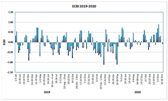
Figure 5.
Time series of the pentad blocking index ECBI in January 2019–December 2020.
4. Conclusions
A comprehensive analysis of the meteorological conditions for the formation of a severe agricultural drought in the Odessa region at the beginning of the growing season of 2020 has shown that this process developed for a long time, gradually gaining intensity. The long-term deficit of precipitation was caused by the high frequency of high-pressure fields (compared to the norm) in the lower and middle troposphere, as well as the lack of conditions for the accumulation of soil moisture in the previous winter period due to high air temperatures and the absence of cyclogenesis processes, which is a typical for cold season in the region.
Institutional Review Board Statement
Not applicable.
Informed Consent Statement
Not applicable.
Data Availability Statement
IRI Analyses SPI: http://iridl.ldeo.columbia.edu/SOURCES/.IRI/.Analyses/.SPI/; Giovanni Online Data System: https://giovanni.gsfc.nasa.gov/giovanni/; ERA5 in KNMI Climate Explorer: https://climexp.knmi.nl; NCEP/NCAR Reanalysis 1: https://psl.noaa.gov/data/gridded/data.ncep.reanalysis.html (accessed on 1 May 2021).
References
- Buchinskij, I.E. Droughts and Dry Winds; Gidrometeoizdat: St. Petersburg, Russia, 1976; p. 214. [Google Scholar]
- UNISDR. Drought Risk Reduction Framework and Practices: Contributing to the Implementation of the Hyogo Framework for Action; United Nations Secretariat of the International Strategy for Disaster Reduction (UNISDR): Geneva, Switzerland, 2009; p. 213. Available online: http://www.unisdr.org/files/11541_DroughtRiskReduction2009library.pdf (accessed on 15 January 2021).
- Drought Monitoring and Early Warning: Concepts, Progress and Future Challenges, Weather and Climate Information for Sustainable Agricultural Development. WMO No. 1006. 2006, p. 24. Available online: https://www.droughtmanagement.info/literature/WMO_drought_monitoring_early_warning_2006.pdf (accessed on 12 May 2021).
- McKee, T.B.; Doesken, N.J.; Kliest, J. Drought monitoring with multiple time scales. In Proceedings of the 9th Conference of Applied Climatology, Dallas, TX, USA, 15–20 January 1995; pp. 233–236. [Google Scholar]
- Jiménez-Donaire, M.P.; Tarquis, A.; Giráldez, J.V. Evaluation of a combined drought indicator and its potential for agricultural drought prediction in southern Spain. Nat. Hazards Earth Syst. Sci. 2020, 20, 21–33. [Google Scholar] [CrossRef] [Green Version]
- Semenova, I.G. Regional atmospheric blocking in the drought periods in Ukraine. J. Earth Sci. Eng. 2013, 3, 341–348. [Google Scholar]
- Semenova, I.; Sumak, K. Cyclonic activity in cold season over territories of Belarus and Ukraine and its relation to the warm season droughts. Croat. Meteorol. J. 2017, 52, 59–73. [Google Scholar]
- Monitoring of Hydrometeorological Activity of the Hydrometeorological Center of Black and Azov Seas for 2020. Available online: http://www.hmcbas.od.ua/2019-11-08-10-35-06.html (accessed on 10 May 2021).
- Semenova, I.H. Synoptic and Climatic Conditions for the Formation of Droughts in Ukraine; FOP Panov A.M.: Kharkiv, Ukraine, 2017; p. 236. [Google Scholar]
- Cherenkova, E.A.; Semenova, I.G.; Kononova, N.K.; Titkova, T.B. Droughts and dynamics of synoptic processes in the south of the East European Plain at the beginning of the twenty-first century. Arid Ecosyst. 2015, 5, 45–56. [Google Scholar] [CrossRef]
Publisher’s Note: MDPI stays neutral with regard to jurisdictional claims in published maps and institutional affiliations. |
© 2021 by the author. Licensee MDPI, Basel, Switzerland. This article is an open access article distributed under the terms and conditions of the Creative Commons Attribution (CC BY) license (https://creativecommons.org/licenses/by/4.0/).