Proceeding Paper

Review of Hybrid Methods for the Characterization of Seismic Hazard in Central America †

by
Carlos Gamboa-Canté
1,*,
Belén Benito
1,
Alicia Rivas-Medina
1,
Ligia Quiros
1,
Mario Arroyo-Solórzano
2 and
Conrad Lindholm
3
1
Escuela Técnica Superior de Ingenieros en Topografía, Geodesia y Cartografía, Universidad Politécnica de Madrid, C/Mercator 2, 28031 Madrid, Spain
2
Helmholtz Centre Potsdam, GFZ German Research Centre for Geosciences and University of Potsdam, 14473 Potsdam, Germany
3
Independent Consultor, 2027 Kjeller, Norway
*
Author to whom correspondence should be addressed.
Presented at the IV Conference on Geomatics Engineering, Madrid, Spain, 6–7 July 2023.
Environ. Sci. Proc. 2023, 28(1), 7; https://doi.org/10.3390/environsciproc2023028007
Published: 21 December 2023
(This article belongs to the Proceedings of IV Conference on Geomatics Engineering)

Abstract

:
This study compares methods that address two key aspects: how to quantify geological information and transfer it to recurrence models, and how to distribute the seismic potential between two types of sources. These methods are as follows: 1) the mom-rate method, 2) the mom-slip method, 3) the Hybrid Method Proposed (MHP), and 4) the method to build hazard models including earthquake ruptures involving several faults named Seismic hazard and earthquake rate in fault systems (SHERIFS). The results show that the peak ground acceleration (PGA) values increase significantly in the vicinity of the faults, when these are modeled as independent sources in the hybrid methods, reaching, in some cases, to be multiplied by a factor of 2.

1. Introduction

It is known that the introduction of faults as independent seismic sources in hazard assessment has a great impact on the results, with respect to those obtained with classical zoning methods (CZM) [1]. Although, at the moment, there are no widely contrasted methodological developments to combine zones and faults in the source models, some approaches have been proposed that use hybrid models (HM) composed of zone-type sources and fault-type. These approaches require modelizing the faults as independent sources, which is possible if geological, paleoseismic, and geodetic data are available.
In this work we compare some methods of seismic hazard assessment (PSHA) that address two key aspects: how to quantify geological information and transfer it to recurrence models, and how to distribute the seismic potential between the two types of sources, i.e., faults and zones. As a pilot zone for the application of the different methods, we take the central zone of Guatemala where the fault systems of Polochic-Chixoy and Motagua are located. According to the study of Alvarado et al. (2017) [2], this is zone G6 for the crustal tectonic regime.
The G6 seismogenic zone has been considered one of the most important areas of Central America for geological, geophysical, seismological, and applied tectonic studies (Figure 1). This zone is located at the contact between two tectonic plates: the North American Plate and the Caribbean Plate. This contact generates the two main fault systems in the region: the Motagua fault system and the Polochic-Chixoy fault system. Due to the constant accumulation of seismic energy in this zone, our study has focused on analyzing, evaluating, and discussing how much the fault system in the region contributes to seismic hazard calculations and its implications for incorporating geological data into such calculations.
To achieve this goal, information has been compiled, such as slip rates, fault geometry, and kinematics, from previous studies by other authors [3,4,5,6,7,8]. By analyzing this information, four possible rupture scenarios have been generated for the study, two of them in the Motagua fault and others two in the Chixoy-Polochic. These scenarios are modelized as independent sources and correspond to the following ruptures:
  • M01: seismicity gap in the Motagua fault [9].
  • M02: segment of Motagua with equal length to the one generated by the earthquake on 4 February 1976 [3].
  • P01: segment with a NE–SW orientation in the Chixoy-Polochic fault that corresponds to the rupture that caused the earthquake on 6 January 1785 [8,10].
  • P02: a E–W rupture that corresponds to the area that caused the earthquake on 22nd July 1816 [4].
A summary of the information for each proposed rupture, obtained from previous studies by other authors, is shown below (Table 1).

2. Materials and Methods
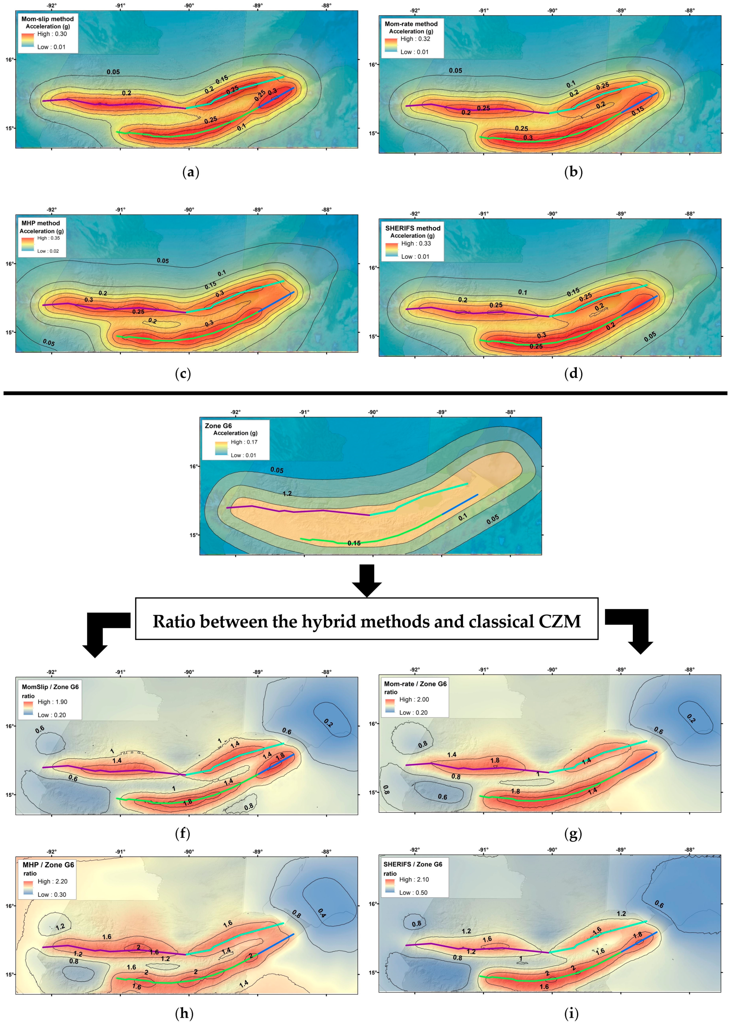
We used four methods to integrate the faults into the calculations of the seismic hazards (Table 2).
These methods are:
  • The mom-slip method, proposed also by Bungum (2007) [11].
  • The mom-rate method, proposed by Bungum (2007) [11].
  • The Hybrid Method Proposed (MHP) by Rivas-Medina et al. (2018) [12].
  • The seismic hazard and earthquake rate in fault systems (SHERIFS) method by Chartier et al. (2019) [13].
An application exercise of the four methods has been carried out in the G6 zone of Guatemala, considering the four rupture scenarios previously proposed. With this, we do not intend to achieve the final results of hazards in the study area, since other neighboring areas are not being considered. The objective of the exercise is to assess the impact of modeling faults as independent sources on the hazard results, compared to the results achieved with the classical zoned method.

3. Results

In order to perform sensitivity analysis of the results, we present the maps of expected ground accelerations, obtained by four different hybrid methods, considering the zone G6 and faults M01, M02, P01 and P02 (Figure 2) as sources. The values of PGA, for a return period of 475 years on rock condition, are shown in these maps. In addition, another map of PGA, for a similar return period, was obtained using the classical zoned method [1] considering only the zone G6. As a result, it was evident that, near the fault systems, there is an amplification of acceleration, due to the integration of fault-type sources in the seismic hazard calculations. Also, Table 3 shows the distribution of the seismic moment of the region for each seismic source, according to each hybrid methodology applied.

4. Discussion and Conclusions

Four rupture scenarios were modeled on the Motagua and Chixoy-Polochic faults and a PSHA calculation was made using four hybrid methods (using zones and faults as sources), thus resulting in four PGA maps for a return period of 475 years. These values were compared with those obtained by the classical zoned method [1]. The results show that the PGA values increase significantly in the vicinity of the faults, when these are modeled as independent sources in the hybrid methods, reaching in some cases to be multiplied by a factor of x2. Accelerations, however, decrease in areas far from the fault, compared to those obtained with classical methods. The dominant distances at which an increase factor is perceived, that is, the impact of the fails, are of the order of 20 km. On the other hand, the distribution of seismic potential between fault systems and background seismicity remains a topic for discussion.
The difference in the results of each method is in the way in which the method distributes the seismic potential of the region to each source that interacts in the region (Table 3). The mom-slip and SHERIFS methods distribute the higher percentage to the source with larger geometry (M02). This is due to the slip rate that interacts with M02 and the rupture area that it generates when applying the scaling laws. The mom-rate method tries to equally distribute the seismic potential according to the geometry of the faults, which is why very similar percentages are observed between the sources. Finally, the MHP method distributes the moment in a more realistic way, based on the information recorded in the seismic catalog and the geometry of the sources, despite the fact that the MHP method, if it considers the information from the seismic catalog, provides a distribution at the moment that is very similar to that given by SHERIFS, which only clearly considers the geometry of the faults and their slip rate. In conclusion, in light of our preliminary results, we can say that the MHP method is the most reliable, followed by SHERIFS, since, despite the fact that both methodologies yield similar results, the MHP method takes into account all the information from the seismic catalog for the distribution of the seismic potential, which is important, compared to the other methods.

Author Contributions

Conceptualization, C.G.-C., B.B., A.R.-M., L.Q., M.A.-S. and C.L.; methodology, C.G.-C., B.B. and A.R.-M.; validation, A.R.-M., L.Q. and M.A.-S.; formal analysis, C.G.-C.; investigation, C.G.-C.; writing—original draft preparation, C.G.-C.; writing—review and editing, B.B., A.R-M. and M.A.-S.; supervision, B.B. All authors have read and agreed to the published version of the manuscript.

Funding

This research was supported by the KUK-AHPÁN Project, grant number RTI2018-094827-B-C21/C22, funded by Ministerio de Ciencia, Innovación y Universidades of the Spanish Government under MCIN/AEI/10.13039/501100011033 and, if applicable, by “FEDER A way to do Europe”.

Data Availability Statement

The data presented in this study are available upon request from the corresponding author. The data are not publicly available because they are part of the project that funded this research.

Conflicts of Interest

The authors declare no conflict of interest.

References

  1. Cornell, A. Engineering Seismic Risk Analysis. Bull. Seismol. Soc. Am. 1968, 58, 1583–1606. [Google Scholar] [CrossRef]
  2. Alvarado, G.E.; Benito, B.; Staller, A.; Climent, Á.; Camacho, E.; Rojas, W.; Marroquín, G.; Molina, E.; Talavera, J.E.; Martínez-Cuevas, S.; et al. The New Central American Seismic Hazard Zonation: Mutual Consensus Based on up to Day Seismotectonic Framework. Tectonophysics 2017, 721, 462–476. [Google Scholar] [CrossRef]
  3. Plafker, G. Tectonic Aspects of the Guatemala Earthquake of 4 February 1976. Sci. New Ser. 1976, 193, 1201–1208. [Google Scholar] [CrossRef] [PubMed]
  4. White, R.A. The guatemala earthquake of 1816 on the chixoy-polochic fault. Bull. Seismol. Soc. Am. 1985, 75, 455–473. [Google Scholar] [CrossRef]
  5. Lyon-Caen, H.; Barrier, E.; Lasserre, C.; Franco, A.; Arzu, I.; Chiquin, L.; Chiquin, M.; Duquesnoy, T.; Flores, O.; Galicia, O.; et al. Kinematics of the North American-Caribbean-Cocos Plates in Central America from New GPS Measurements across the Polochic-Motagua Fault System. Geophys. Res. Lett. 2006, 33. [Google Scholar] [CrossRef]
  6. Franco, A.; Molina, E.; Lyon-Caen, H.; Vergne, J.; Monfret, T.; Nercessian, A.; Cortez, S.; Flores, O.; Monterosso, D.; Requenna, J. Seismicity and Crustal Structure of the Polochic-Motagua Fault System Area (Guatemala). Seismol. Res. Lett. 2009, 80, 977–984. [Google Scholar] [CrossRef]
  7. Garnier, B.; Tikoff, B.; Flores, O.; Jicha, B.; DeMets, C.; Cosenza-Muralles, B.; Hernandez, W.; Greene, D. Deformation in Western Guatemala Associated With the NAFCA (North America-Central American Forearc-Caribbean) Triple Junction: Neotectonic Strain Localization Into the Guatemala City Graben. Tectonics 2022, 41. [Google Scholar] [CrossRef]
  8. Authemayou, C.; Brocard, G.; Teyssier, C.; Suski, B.; Cosenza, B.; Morán-Ical, S.; González-Véliz, C.W.; Aguilar-Hengstenberg, M.A.; Holliger, K. Quaternary Seismo-Tectonic Activity of the Polochic Fault, Guatemala. J. Geophys. Res. Solid. Earth 2012, 117. [Google Scholar] [CrossRef]
  9. Graham, S.E.; Demets, C.; Deshon, H.R.; Rogers, R.; Maradiaga, M.R.; Strauch, W.; Wiese, K.; Hernandez, D. GPS and Seismic Constraints on the M = 7.3 2009 Swan Islands Earthquake: Implications for Stress Changes along the Motagua Fault and Other Nearby Faults. Geophys. J. Int. 2012, 190, 1625–1639. [Google Scholar] [CrossRef]
  10. White, R.A. Catalog of Historic Seismicity in the Vicinity of the Chixoy-Polochic and Motagua Faults, Guatemala; U.S. Geological Survey: Menlo Park, CA, USA, 1984; p. 26.
  11. Bungum, H. Numerical Modelling of Fault Activities. Comput Geosci 2007, 33, 808–820. [Google Scholar] [CrossRef]
  12. Rivas-Medina, A.; Benito, B.; Miguel Gaspar-Escribano, J. Approach for Combining Fault and Area Sources in Seismic Hazard Assessment: Application in South-Eastern Spain. Nat. Hazards Earth Syst. Sci. 2018, 18, 2809–2823. [Google Scholar] [CrossRef]
  13. Chartier, T.; Scotti, O.; Lyon-Caen, H. SHERIFS: Open-Source Code for Computing Earthquake Rates in Fault Systems and Constructing Hazard Models. Seismol. Res. Lett. 2019, 90, 1678–1688. [Google Scholar] [CrossRef]
Figure 1. Zone G6 proposed by Alvarado et al. (2017), with the fault systems of Chixoy-Polochic (top) and Motagua (bottom). The four rupture scenarios, modelized as independent sources for estimation of the seismic hazard by hybrid model, are marked as follows: P01, P02, M01, and M02. Recorded seismicity is also represented.
Environsciproc 28 00007 g001
Figure 2. Result maps of PGA obtained using hybrid methods: (a) mom-slip, (b) mom-rate, (c) MHP, and (d) SHERIFS. (e) The map of PGA obtained using the classical zoning method (CZM) for the G6 zone. And finally, the ratio maps between the PGA value obtained with hybrid methods and the CZM method for: (f) mom-slip, (g) mom-rate, (h) MHP, and (i) SHERIFS.
Environsciproc 28 00007 g002
Table 1. Parameters of the independent sources for estimation of seismic hazard.
CodeFault TypeRake
°
Dip
°
Long. (Km)Width (Km)L/WSlip Rate (mm/yr)Error
Slip Rate (mm/yr)
Stiffness (MPa)
M01Sinistral
strike-slip
0.090.065.018.03.614.01.9300.0
M02Sinistral
strike-slip
0.090.0239.718.013.312.01.9300.0
P01Sinistral
strike-slip
0.090.0168.118.09.33.71.2300.0
P02Sinistral
strike-slip
0.090.0232.018.012.93.71.2300.0
Table 2. Main characteristics of the different methods used to combine zone type sources fault type sources.
DescriptionMom-Slip,
Bungum (2007)
Mom-Rate,
Bungum (2007)
MHP, Rivas-Medina
et al. (2018)
SHERIFS, Chartier
et al. (2019)
Level of knowledgeLow LowMiddleHigh
Rupture hypothesisIndividualIndividualIndividualMultiple
Seismicity distribution modelsGR 1GR 1GR-modifiedGR 1, YC 5, GR-modified, YC modified, non-parametric
Criteria of expertsb-value of the faultb-value of the fault, %Mom 3MMC 4, b-value
region, b-value
background
Ratio R 6, FtF hypothesis 7
OutputsṄmin 2 of the faultGR 1 of the faultMFD 8 of faults and backgroundMFD 8 of faults,
ruptures FtF and
Background
1 GR = Gutenberg–Richter (1956) model. 2 Ṅmin = Accumulative seismicity rate for M ≤ Mmin. 3 %Mom = Distribution percentage of the released seismic moment. 4 MMC = Minimum share magnitude from which seismicity is associated with faults. 5 YC = Youngs–Coppersmith (1985) characteristic earthquake model. 6 Ratio R = Distribution of seismicity between background and faults for each magnitude. 7 FtF = Hypothesis of rupture fault to fault. 8 MFD = Magnitude–frequency distribution.
Table 3. Percentage of the distribution of the seismic moment in each source.
CodeMom-Slip,
Bungum
(2007)
Mom-Rate,
Bungum
(2007)
MHP, Rivas-
Medina et al. (2018)
SHERIFS,
Chartier et al. (2019)
M0116.75%34.04%15.41%12.35%
M0255.00%29.28%48.72%53.93%
P0111.81%18.11%10.53%11.62%
P0216.44%18.57%14.52%16.00%
Background------10.80%6.10%
Disclaimer/Publisher’s Note: The statements, opinions and data contained in all publications are solely those of the individual author(s) and contributor(s) and not of MDPI and/or the editor(s). MDPI and/or the editor(s) disclaim responsibility for any injury to people or property resulting from any ideas, methods, instructions or products referred to in the content.

