
Cloud Types and Geometrical Properties Observed above PANGEA Observatory in the Eastern Mediterranean †

 , , , , and
Abstract
:1. Introduction
2. Data and Methodology
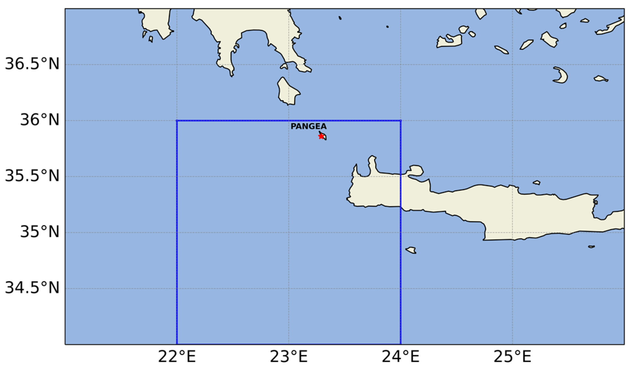
2.1. Study Area
2.2. Dataset
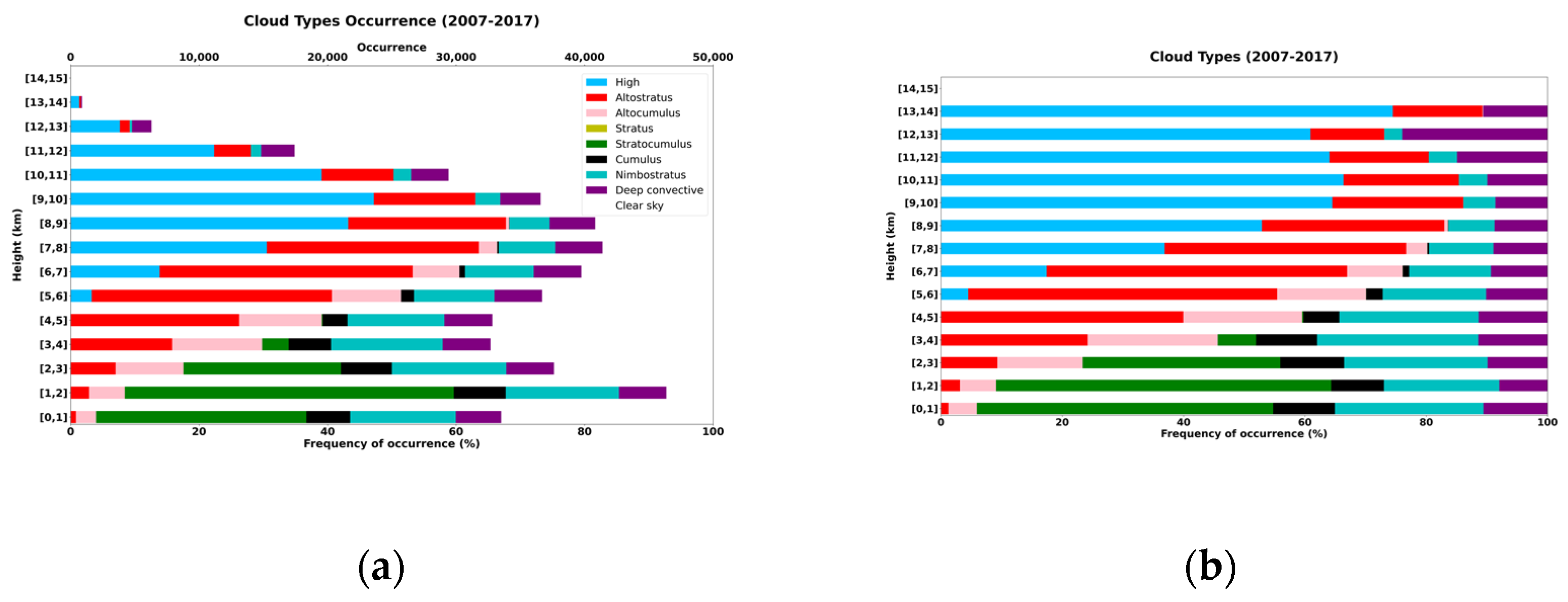
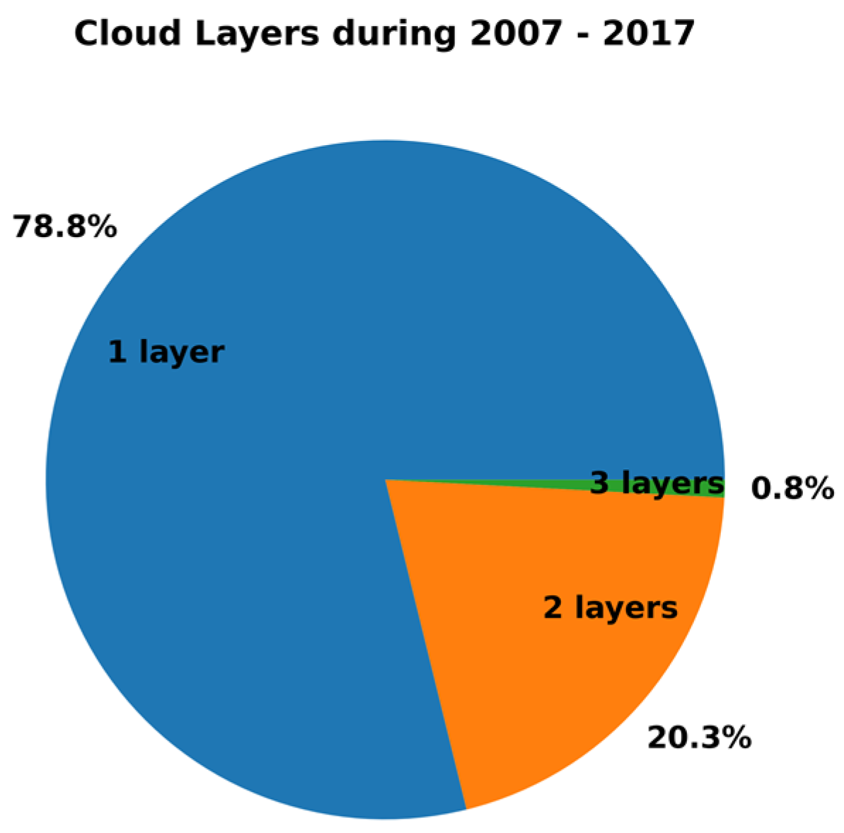
3. Results
4. Conclusions and Future Work
Author Contributions
Funding
 .
.Institutional Review Board Statement
Informed Consent Statement
Data Availability Statement
Conflicts of Interest
References
- IPCC. Climate Change 2014: Synthesis Report. Contribution of Working Groups I, II and III to the Fifth Assessment Report of the Intergovernmental Panel on Climate Change; Pachauri, R.K., Meyer, L.A., Eds.; IPCC: Geneva, Switzerland, 2014; p. 151. [Google Scholar]
- Korolev, A.; McFarquhar, G.; Field, P.R.; Franklin, C.; Lawson, P.; Wang, Z.; Williams, E.; Abel, S.J.; Axisa, D.; Borrmann, S.; et al. Mixed-Phase Clouds: Progress and Challenges. Meteor. Mon. 2017, 58, 5.1–5.50. [Google Scholar] [CrossRef]
- Tan, I.; Storelvmo, T.; Zelinka, M.D. Observational constraints on mixed-phase clouds imply higher climate sensitivity. Science 2016, 352, 224–227. [Google Scholar] [CrossRef] [PubMed]
- Forbes, R.M.; Ahlgrimm, M. On the Representation of High-Latitude Boundary Layer Mixed-Phase Cloud in the ECMWF Global Model. Mon. Weather Rev. 2014, 142, 3425–3445. [Google Scholar] [CrossRef]
- Miglietta, M.M.; Moscatello, A.; Conte, D.; Mannarini, G.; Lacorata, G.; Rotunno, R. Numerical analysis of a Mediterranean ‘hurricane’ over south-eastern Italy: Sensitivity experiments to sea surface temperature. Atmos. Res. 2011, 101, 412–426. [Google Scholar] [CrossRef]
- Marinou, E.; Voudouri, K.A.; Tsikoudi, I.; Drakaki, E.; Tsekeri, A.; Rosoldi, M.; Ene, D.; Baars, H.; O’Connor, E.; Amiridis, V.; et al. Geometrical and Microphysical Properties of Clouds Formed in the Presence of Dust above the Eastern Mediterranean. Remote Sens. 2021, 13, 5001. [Google Scholar] [CrossRef]
- Gkikas, A.; Gialitaki, A.; Binietoglou, I.; Marinou, E.; Tsichla, M.; Siomos, N.; Paschou, P.; Kampouri, A.; Voudouri, K.A.; Proestakis, E.; et al. First assessment of Aeolus Standard Correct Algorithm particle backscatter coefficient retrievals in the eastern Mediterranean. Atmos. Meas. Tech. 2023, 16, 1017–1042. [Google Scholar] [CrossRef]
- Stephens, G.; Wood, N. Properties of tropical convection observed by millimeter-wave radar systems. Mon. Weather Rev. 2007, 135, 821–842. [Google Scholar] [CrossRef]
- Stephens, G.; Vane, D.G.; Boain, R.J.; Mace, G.G.; Sassen, K.; Wang, Z.; Mitrescu, C. The CloudSat mission and the A-Train. Bull. Am. Meteorol. Soc. 2002, 83, 1771–1790. [Google Scholar] [CrossRef]
- Mace, G.; Marchand, R.; Zhang, Q.; Stephens, G. Global hydro-meteor occurrence as observed by CloudSat: Initial observations fromsummer. Geophys. Res. Lett. 2007, 34, L09808. [Google Scholar] [CrossRef]
- Marchand, R.; Mace, G.; Ackerman, T.; Stephens, G. Hydro-meteor detection using CloudSat an Earth-orbiting 94-GHz cloud radar. J. Atmos. Ocean. Technol. 2008, 25, 519–533. [Google Scholar] [CrossRef]
- Sassen, K.; Wang, Z. Classifying clouds around the globe with the CloudSat radar: 1-year of results. Geophys. Res. Lett. 2008, 35, L04805. [Google Scholar] [CrossRef]
- Sassen, K.; Wang, Z. Level 2 Cloud Scenario Classification Product Process Description and Interface Control Document, Version 5.0. 2007. Available online: http://cloudsat.cira.colostate.edu/dataICDlist.php?go=list&path=/2B-CLDCLASS (accessed on 2 June 2006).
- Pan, B.; Liu, D.; Du, Y.; Zhao, D.; Hu, K.; Ding, S.; Yu, C.; Tian, P.; Wu, Y.; Li, S.; et al. Intercomparisons on the vertical profiles of cloud microphysical properties from CloudSat retrievals over the North China Plain. J. Geophys. Res. Atmos. 2023, 128, e2023JD039093. [Google Scholar] [CrossRef]
- Huo, J.; Lu, D. Physical Properties of High-Level Cloud over Land and Ocean from CloudSat–CALIPSO Data. J. Clim. 2014, 27, 8966–8978. [Google Scholar] [CrossRef]
- Marinou, E.; Tesche, M.; Nenes, A.; Ansmann, A.; Schrod, J.; Mamali, D.; Tsekeri, A.; Pikridas, M.; Baars, H.; Engelmann, R.; et al. Retrieval of ice-nucleating particle concentrations from lidar observations and comparison with UAV in situ measurements. Atmos. Chem. Phys. 2019, 19, 11315–11342. [Google Scholar] [CrossRef]

Disclaimer/Publisher’s Note: The statements, opinions and data contained in all publications are solely those of the individual author(s) and contributor(s) and not of MDPI and/or the editor(s). MDPI and/or the editor(s) disclaim responsibility for any injury to people or property resulting from any ideas, methods, instructions or products referred to in the content. |
© 2023 by the authors. Licensee MDPI, Basel, Switzerland. This article is an open access article distributed under the terms and conditions of the Creative Commons Attribution (CC BY) license (https://creativecommons.org/licenses/by/4.0/).
Share and Cite
Koutsoupi, I.; Marinou, E.; Voudouri, K.A.; Tsikoudi, I.; Paschou, P.; Amiridis, V.; Battaglia, A.; Kollias, P.; Giannakaki, E. Cloud Types and Geometrical Properties Observed above PANGEA Observatory in the Eastern Mediterranean. Environ. Sci. Proc. 2023, 26, 205. https://doi.org/10.3390/environsciproc2023026205
Koutsoupi I, Marinou E, Voudouri KA, Tsikoudi I, Paschou P, Amiridis V, Battaglia A, Kollias P, Giannakaki E. Cloud Types and Geometrical Properties Observed above PANGEA Observatory in the Eastern Mediterranean. Environmental Sciences Proceedings. 2023; 26(1):205. https://doi.org/10.3390/environsciproc2023026205
Chicago/Turabian StyleKoutsoupi, Iliana, Eleni Marinou, Kalliopi Artemis Voudouri, Ioanna Tsikoudi, Peristera Paschou, Vassilis Amiridis, Alessandro Battaglia, Pavlos Kollias, and Eleni Giannakaki. 2023. "Cloud Types and Geometrical Properties Observed above PANGEA Observatory in the Eastern Mediterranean" Environmental Sciences Proceedings 26, no. 1: 205. https://doi.org/10.3390/environsciproc2023026205
APA StyleKoutsoupi, I., Marinou, E., Voudouri, K. A., Tsikoudi, I., Paschou, P., Amiridis, V., Battaglia, A., Kollias, P., & Giannakaki, E. (2023). Cloud Types and Geometrical Properties Observed above PANGEA Observatory in the Eastern Mediterranean. Environmental Sciences Proceedings, 26(1), 205. https://doi.org/10.3390/environsciproc2023026205