
Design of a Smart Early Warning Hydrometeorological System: The Easy Project in Ermionida †

 ,
,  and
and 
Abstract
:1. Introduction
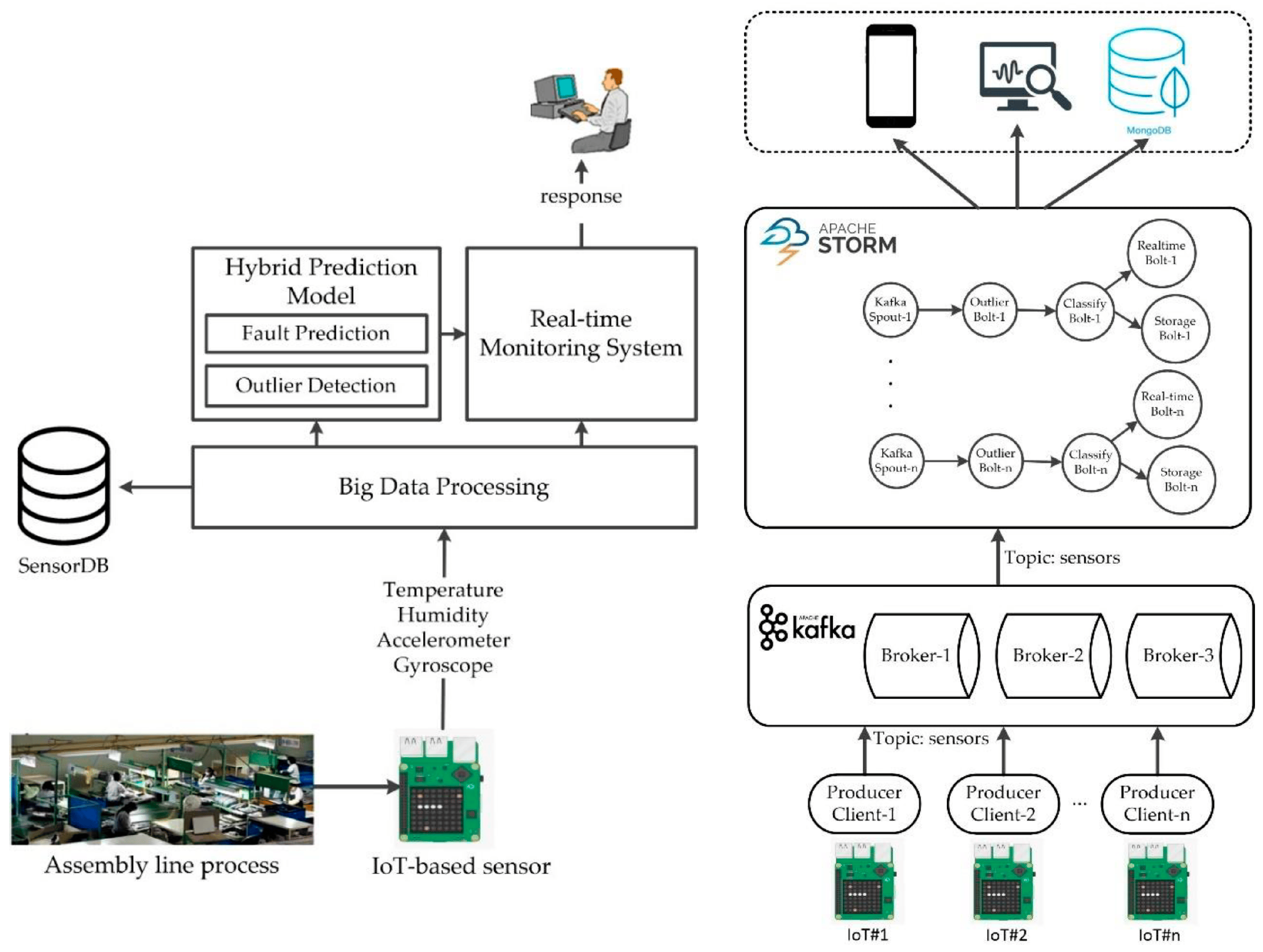
2. Materials and Methods
2.1. IoT Sensors
- Tipping Bucket Rainfall Sensor: an instrument for testing rainfall in nature. In order to meet the requirement of information transmission, processing, recording and display, the amount of rainfall is converted to a pulse output.
- Ultrasonic Automatic Weather Sensor: an automatic weather instrument that simultaneously measures the atmospheric temperature, atmospheric humidity, air pressure, wind speed, wind direction, solar radiation, illuminance/UV, dust concentration and precipitation. Temperature, humidity and air pressure sensors are placed within the radiation shield.
- Ultrasonic liquid level sensors: sensors that emit ultrasonic pulses of sound, use piezoelectric transducers to generate sound waves in the ultrasonic range (typically, frequencies exceed 40 KHz) and can operate with both liquid and dry media. In the frame of the current study, they are used to estimate the velocity of soundwaves in liquid media.
2.2. Development of Smart Hydrometeorological Early Warning System
- Hydrological data, i.e., measurements of stage, discharge, etc.
- Meteorological data, i.e., available information on weather patterns and predictions for precipitation depth, wind speed, air temperature and atmospheric pressure, and corresponding real-time monitoring.
- Historical data, i.e., long-term records of past flood events that may provide an indicative scheme for the identification of future flood events.
2.3. Development of the Application for the Meteorological Measurements
3. Expected Results and Conclusions
- Map viewer. A larger map on the system’s central screen will be displayed, including the available stations and the ability to view the latest measurements and station information in pop-up windows that emerge on the map.
- Display. It will allow the simultaneous creation of multiple graphical representations with data from all available sensors at each station. Multiple options should be available in the graphical representation, such as zooming, viewing selected graphical representations from those already generated, etc.
- Data acquisition. Viewing/exporting all measurements from each station will be possible. It will have the ability to export data per station and per sensor in CSV and/or Excel format.
- Chart generator. Automatic generation of charts for one or more selected measurements, per measurement station and per time interval, based on user-defined parameters, will be possible.
- Analyst. There will be the possibility of automatic processing of historical time series to calculate various statistical measures (e.g., mean, minimum, maximum) on an hourly, daily, monthly and annual basis.
- EWS thresholds. It will have the capability to display notification thresholds on the graphical representations of respective parameters.
- Accessibility for users. The platform will allow the simultaneous monitoring of measurements by different users. It will support graded access for the roles (a) general administrator, (b) group administrator and (c) regular user.
Author Contributions
Funding
Institutional Review Board Statement
Informed Consent Statement
Data Availability Statement
Acknowledgments
Conflicts of Interest
References
- Mechler, R.; Bouwer, L.M.; Schinko, T.; Surminski, S.; Linnerooth-Bayer, J. (Eds.) Loss and Damage from Climate Change: Concepts, Methods and Policy Options; Springer Nature: New York, NY, USA, 2019. [Google Scholar]
- Meyers, R.A. (Ed.) Extreme Environmental Events: Complexity in Forecasting and Early Warning, 2011th ed.; Springer: New York, NY, USA, 2010; ISBN 978-1-4419-7694-9. [Google Scholar]
- Attribution of Extreme Weather Events in the Context of Climate Change; National Academies Press: Washington, DC, USA, 2016; ISBN 978-0-309-38094-2.
- Singh, A.; Zommers, Z. Reducing Disaster: Early Warning Systems for Climate Change; Springer: Dordrecht, The Netherlands, 2014; ISBN 978-94-017-8597-6. [Google Scholar]
- Baldassarre, G.D. Floods in a Changing Climate: Inundation Modelling; Cambridge University Press: Cambridge, UK, 2012; ISBN 978-1-107-01875-4. [Google Scholar]
- European Environment Agency. Annual Report 2004; Office for Official Publications of the European Communities: Luxembourg, 2005; pp. 16–17. [Google Scholar]
- Zschau, J.; Küppers, A.N. (Eds.) Early Warning Systems for Natural Disaster Reduction; Softcover reprint of the original 1st ed. 2003 edition; Springer: Berlin/Heidelberg, Germany, 2014; ISBN 978-3-642-63234-1. [Google Scholar]
- Feloni, E. Assessment of Flood Induced by Heavy Rainfall Using Advanced Methodologies, as a Premise for an Integrated Flood Early Warning System: The Case of Attica Region. Ph.D. Thesis, School of Civil Engineering of National Technical University of Athens, Athens, Greece, February 2019. [Google Scholar]
- Mainetti, L.; Patrono, L.; Vilei, A. Evolution of Wireless Sensor Networks towards the Internet of Things: A Survey. In Proceedings of the SoftCOM 2011, 19th International Conference on Software, Telecommunications and Computer Networks, Split, Croatia, 15–17 September 2011. [Google Scholar]
- World Meteorological Organization (WMO). Guide to Meteorological Instruments and Methods of Observation, 7th ed., Geneva, 2008. Available online: https://www.weather.gov/media/epz/mesonet/CWOP-WMO8.pdf (accessed on 1 June 2023).
- World Meteorological Organization (WMO). Manual on Stream Gauging; WMO: Geneva, Switzerland, 2010. [Google Scholar]
Disclaimer/Publisher’s Note: The statements, opinions and data contained in all publications are solely those of the individual author(s) and contributor(s) and not of MDPI and/or the editor(s). MDPI and/or the editor(s) disclaim responsibility for any injury to people or property resulting from any ideas, methods, instructions or products referred to in the content. |
© 2023 by the authors. Licensee MDPI, Basel, Switzerland. This article is an open access article distributed under the terms and conditions of the Creative Commons Attribution (CC BY) license (https://creativecommons.org/licenses/by/4.0/).
Share and Cite
Chasiotis, A.; Chasiotis, S.; Theodorakis, C.; Bousdeki, M.; Feloni, E.; Nastos, P.T. Design of a Smart Early Warning Hydrometeorological System: The Easy Project in Ermionida. Environ. Sci. Proc. 2023, 26, 185. https://doi.org/10.3390/environsciproc2023026185
Chasiotis A, Chasiotis S, Theodorakis C, Bousdeki M, Feloni E, Nastos PT. Design of a Smart Early Warning Hydrometeorological System: The Easy Project in Ermionida. Environmental Sciences Proceedings. 2023; 26(1):185. https://doi.org/10.3390/environsciproc2023026185
Chicago/Turabian StyleChasiotis, Angelos, Stefanos Chasiotis, Christos Theodorakis, Maria Bousdeki, Elissavet Feloni, and Panagiotis T. Nastos. 2023. "Design of a Smart Early Warning Hydrometeorological System: The Easy Project in Ermionida" Environmental Sciences Proceedings 26, no. 1: 185. https://doi.org/10.3390/environsciproc2023026185
APA StyleChasiotis, A., Chasiotis, S., Theodorakis, C., Bousdeki, M., Feloni, E., & Nastos, P. T. (2023). Design of a Smart Early Warning Hydrometeorological System: The Easy Project in Ermionida. Environmental Sciences Proceedings, 26(1), 185. https://doi.org/10.3390/environsciproc2023026185