Proceeding Paper

Modeling the Impact of the Green Roofs as a Nature-Based Solution to Mitigate the Urban Heat Island Effects over Attica, Greece †

1
Department of Geography, Harokopio University of Athens, HUA, 17671 Athens, Greece
2
Research Centre for Atmospheric Physics and Climatology, Academy of Athens, 10679 Athens, Greece
3
Institute of Earth Surface Dynamics, University of Lausanne, 1015 Lausanne, Switzerland
4
Department of Agriculture Development, Agri-Food and Natural Resources Management, National and Kapodistrian University of Athens, 15772 Psachna, Greece
5
Innovative Technologies Centre S.A. (ITC), 11633 Athens, Greece
*
Author to whom correspondence should be addressed.
Presented at the 16th International Conference on Meteorology, Climatology and Atmospheric Physics—COMECAP 2023, Athens, Greece, 25–29 September 2023.
Environ. Sci. Proc. 2023, 26(1), 174; https://doi.org/10.3390/environsciproc2023026174
Published: 5 September 2023

Abstract

:
The main aim of this study is to model the Nature-based solution of Green Roofs (GRs) in order to assess their efficiency as a mitigation strategy for UHI effects and extreme summertime temperatures over Attica in Greece. The area of study is a region that encompasses Athens, the largest Metropolitan area of Greece, and the suburbs. The analysis has been performed with the use of an advanced modeling system that consists of the mesoscale Weather Research and Forecasting model (WRF) and the advanced multilayer urban canopy scheme building energy parameter and building energy model (BEP/BEM). The two modules are fully coupled, forming WRF urban. For a better description of the urban environment and in order to use the full capabilities of the urban canopy scheme, 11 urban classes corresponding to the WUDAPT Local Climate Zones (LCZ) were used instead of the 3 traditional urban classes that the default version uses. Sensitivity tests for a major heatwave that affected the area of study have been performed in order to evaluate the impact of GRs on the UHI structure. Results indicate that the modification of the roof energy budget decreased the maximum temperature during heatwaves and altered the spatio-temporal pattern of the effect.

1. Introduction

One of the most important problems of middle-sized and large-sized cities is the urban heat island (UHI) effect. As the urban population increases and the green/vegetated areas in the city decrease, the UHI effect strengthens. Climate change has had two important effects on heat islands: it has increased the mean global temperature, which strengthens the heat islands, and it has produced more frequent and prolonged heat waves, which affect the extreme heat conditions of urban areas. In this context, urban planning aims to find methods to mitigate these effects.
GRs are one of the proposed Nature-based solutions for the reduction of the heat island effect. Using GRs in a built-up environment with limited vegetation can reduce both the roof and the ambient temperature significantly, especially during daytime and periods of excessive heat. They can also reduce building energy consumption for cooling by 0.7% compared to conventional roofs, and, as a result, they can reduce peak electricity demand [1,2]. In this study, an advanced numerical modeling approach is used along with a detailed description of the urban landscape in order to assess the impact of GRs on ambient temperature and on the alleviation of the heat island effect.

2. Materials and Methods
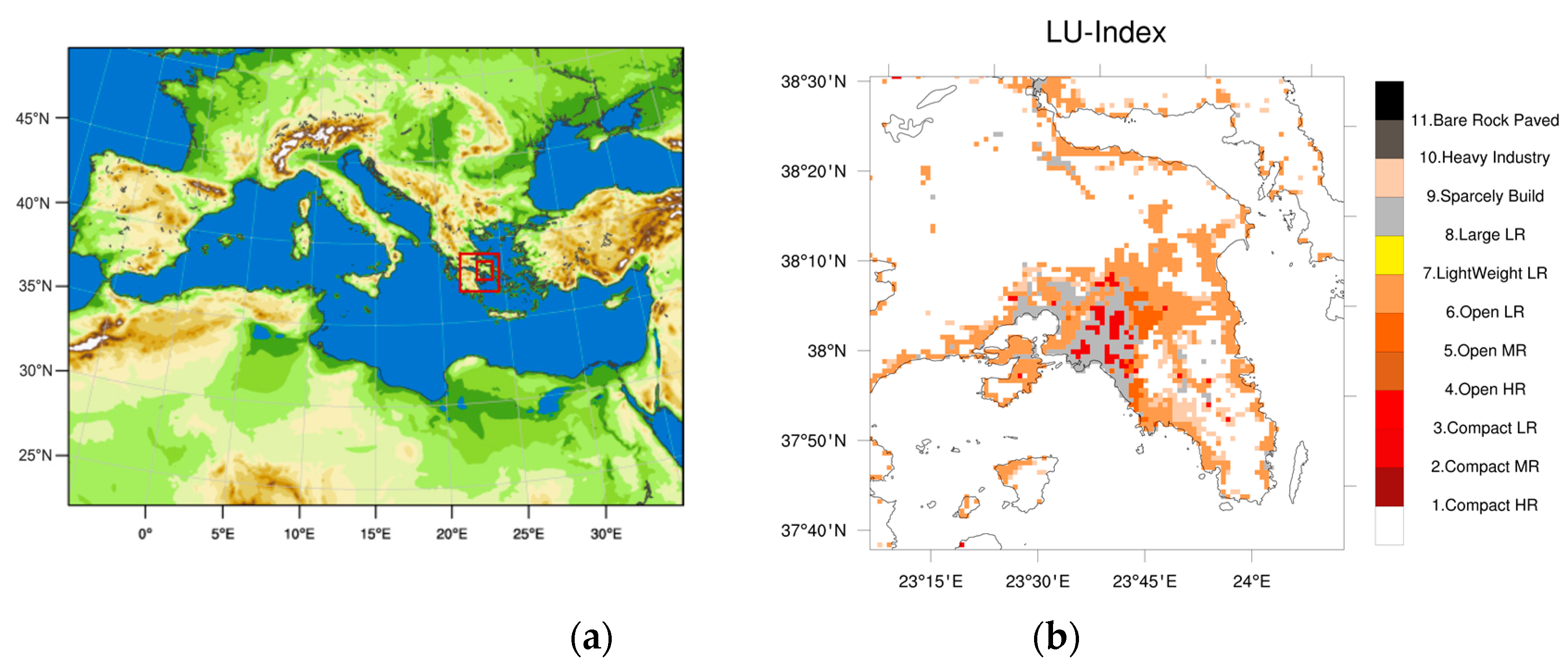
2.1. Study Area

The study region is the Attica basin, which includes the greater Athens area and the built-up zone that extends beyond the central plain. It is characterized by a complex and unique geomorphology since it is a coastal area that is bounded by mountains to W–NW and E–NE. During summer months, HWs are frequent events, especially during July and August [3]. The period of study in this paper is during the prolonged HW event from 28 July to 05 August 2021. Three days during this event were selected to study the impact of GRs on the UHI. The adopted methodology is described in this section.

2.2. Modeling System

The modeling system utilized for this study is the mesoscale Weather Research and Forecasting model (WRF v4.3.3) [4]. In the standard version, the land-atmosphere interaction is represented through the Noah land surface model. The latter considers urban areas as horizontal homogeneous surfaces with specific urban surface properties (USP) (albedo, surface emissivity, soil moisture availability, etc.). The USPs are assigned either according to MODIS urban class or to USGS Land Use classification [5]. In this study, WRF is set up to use an Urban Canopy Model (UCM) instead of the Noah LSM model when urban areas are considered. Utilizing a multi-layer UCM to describe heat, momentum, and TKE exchanges inside the urban canopy layer is the most accurate approach because sources/sinks do not exist only at the ground surfaces but are also vertically distributed on building walls and roofs [6].
The UCM used for the estimation of the city scale effects on the dynamics, thermodynamics, and radiation estimation inside the urban canopy is the BEP/BEM. The selected parameterization is considered as the most advanced method to investigate the UHI effect because the BEP/BEM is a multi-layer Building Energy Parameter (BEP) scheme coupled with a Building Energy Model (BEP/BEM) [6,7]. The BEP computes the impact of the urban buildings and surfaces, horizontal (roof and canyon floor) and vertical (building walls), on the momentum, heat, and turbulent kinetic energy [6], while the BEM has the advantage that it accounts for the anthropogenic heat component and, in particular, models the impact of air-conditioning and heat exchange between the interior of buildings and the outer environment. It was found that fluxes exchanged between buildings and the atmosphere play an important role in the urban climate [7]. Finally, the BEP/BEM incorporates a land-surface scheme for GRs [8,9]. It is a 1D model that calculates the energy and moisture budget by taking into account the incoming net radiation, the precipitation or irrigation, the evapotranspiration heat exchange, and the diffusion of heat and moisture from soil [9].
In order to use the full capabilities of such an advanced urban canopy scheme, the default urban land cover from MODIS is replaced by 11 new urban categories that are based on the Local Climate Zones classification [10]. This classification is universal, and is a product of the World Urban Database and Access Portal Tools (WUDAPT) project. It is a community-based project that aims to acquire and provide information on urban morphology that is relevant to climate, weather, and environment studies on a worldwide basis [11]. The LCZ classification comprise 17 zones, 10 of which are referred to as urban and 1 as rock and paved (Table 1). The classification is based on the surface structure (e.g., building and tree height, density) and surface cover (pervious vs. impervious) properties. Each zone is local in scale, representing horizontal distances of 100 s of m to several km. LCZs link distinct urban types to important surface parameters, which can be used in urban modeling. A total of 11 urban LCZ, as retrieved from the European LCZ map, were used to define the urban land cover inside WRF for the Attica region (Figure 1b) [12].

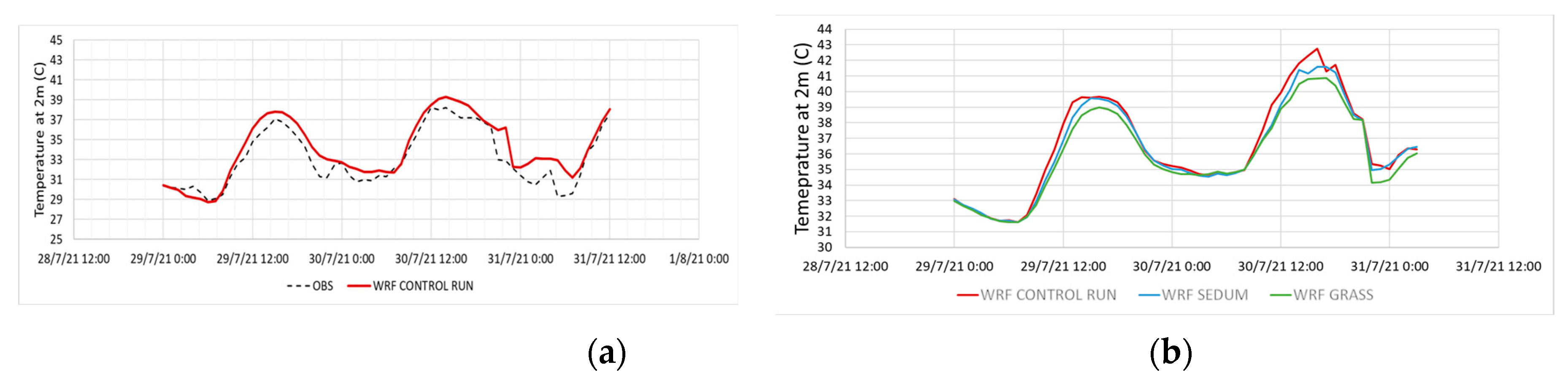
2.3. Sensitivity Analysis
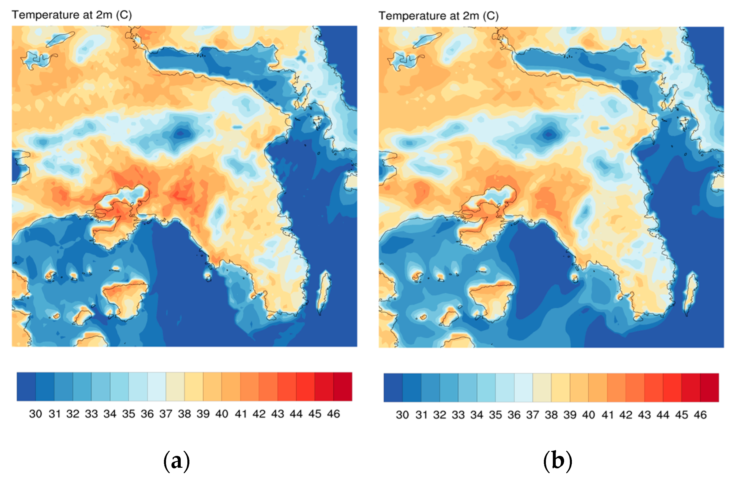
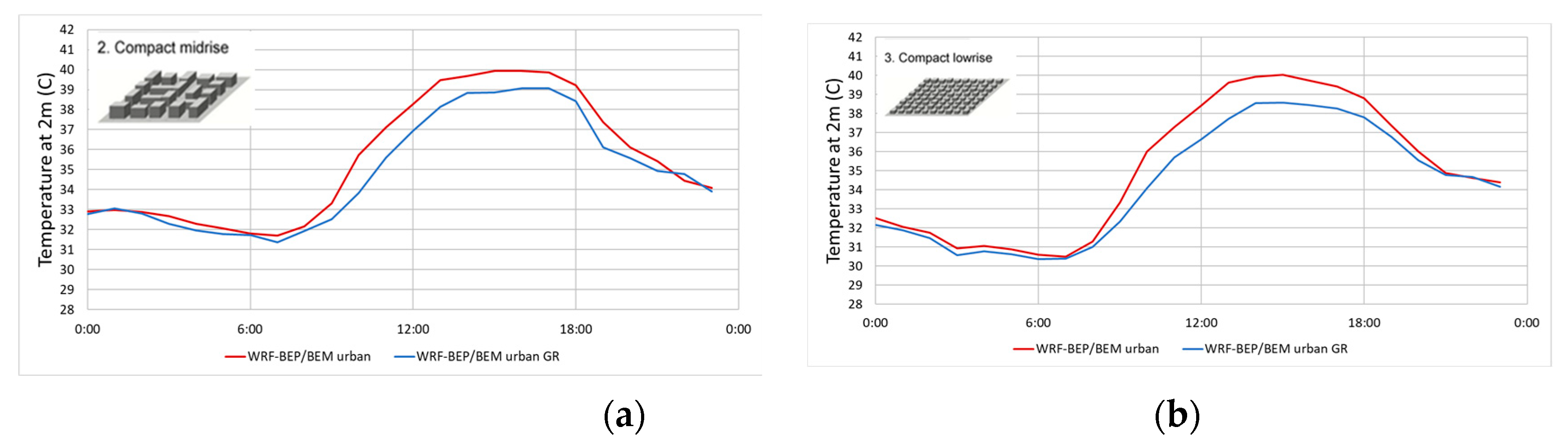
WRF-BEP/BEM was set up to operate with three two-way nested domains. The parent domain extends over the entire European continent and Northern Africa with a 9 km horizontal resolution. The first nested grid extends over Greece with a resolution of 3 km, while the final high-resolution grid covers Attica at a 1-km resolution (Figure 1a). Vertically, all of the domains are described by 45 layers. The first four levels were selected to be inside the urban canopy (about 10 m thick each). The initial and the boundary conditions used are retrieved from the ERA5 reanalysis dataset (ECMWF) with a horizontal resolution of 0.25° × 0.25°, and they are updated every 6 h.
To study the effect of GRs on urban temperature and the extent and intensity of the UHI over Attica during a HW event, 72-h simulations were performed for the period 28–31 July 2021. In particular, a control run and two additional simulations for two GR scenarios were performed: (1) GRASS, which was GRs with grass, and (2) SEDUM, which was GRs covered with sedum. In both cases, the roofs were considered completely covered with a green roof. In dry and moderate climates, sedum is assumed to be an ideal vegetation type that is compatible with NBS and that can withstand weather conditions [8].

3. Results

WRF-BEP/BEM successfully captured the daily variation of air temperature at 2 m, as indicated by the comparison with data from a met station located in Agia Paraskevi. This comparison indicated that the model overestimates the temperature during the night (Figure 2a). This can be attributed to an overestimation of the anthropogenic heat emitted during the night by the BEM model [13]. In all of the selected scenarios, GRs reduced the ambient temperature at 2 m mainly during daytime (Figure 2b). Between the two GR scenarios, grass provided the highest cooling effect compared to sedum (Figure 2a). Grass cover reduced the temperature at 2 m, reaching a reduction of 2 °C during the peak radiation hours, while sedum did not show much of a cooling impact during the same period. This is mainly because sedum vegetation is less effective in converting solar radiation to latent heat flux [8]. Since grass cover provides the best results, the rest of the analysis is based on the GRASS scenario simulations.
Extending the analysis to an area scale, the modification of the roof energy budget due to GR altered the spatial pattern of the temperature and reduced the UHI effect (Figure 3). Compact urban areas that create hotspots with higher temperatures reduce their temperature under the influence of GR (Figure 3). The areas affected the most by the implementation of GRs are those with buildings of lower height. Two characteristic examples are the Athens City center, which is characterized as a compact mid-rise area by the LCZs inside WRF-BEP/BEM, and the Acharnai Center, which is characterized as a compact low-rise area (Figure 4). Both of these areas have a dense mix, few to no trees, and land cover that is mostly paved, and they differ only regarding the heights of the two buildings. The first area includes buildings of 3–9 storeys, while the second one includes buildings with 1–3 storeys The analysis indicated that the reduction in temperature at 2 m was higher in the second case of the mid-rise area. During nighttime, both revealed a small and comparable reduction (Figure 4).

4. Conclusions

In this study, the effectiveness of GRs as a roof top mitigation strategy to reduce the UHI over Attica was assessed during a HW event. WRF coupled with the BEP/BEM urban canopy model was utilized in order to describe the spatial and temporal distribution of near-surface temperature in the urban environment. For a more detailed description of the urban environment, 11 urban categories based on LCZ were used.
The results of this analysis indicated that the modeling system proposed is capable of reproducing the daily profile of the temperatures. The overestimations on temperature and especially during the night indicate that there is a need for a careful calibration of the urban canopy properties that have been assigned to the LCZ, which may contain inaccuracies. The model is sensitive to inaccurate land surface representation, and, thus, extra caution is needed when an area is misrepresented by LCZ.
Regarding GR, both scenarios reduced the ambient temperature. GRASS compared to SEDUM yielded better results. However, SEDUM is a more suitable vegetation type that can withstand weather conditions in dry and moderate climates. The areas that are mostly affected by the implementation of GRs are the low-rise areas where the rooftops are closer to the surface. Finally, the spatial distribution and the intensity of UHI was significantly improved mostly during daytime near the peak of the incoming radiation.

Author Contributions

C.K. contributed to the methodology, formal analysis, investigation, visualization, and writing––original draft preparation; P.M.S. contributed to the methodology, visualization, and review; C.S., M.K., A.P., M.L., and C.M. contributed to the methodology, review, and editing; P.K. contributed to the conceptualization, methodology, supervision, investigation, review, and editing. All authors have read and agreed to the published version of the manuscript.

Funding

This research has been co-financed by the European Regional Development Fund of the European Union and Greek national funds through the Regional Operational Program ‘ATTIKI’–ESPA 2014–2020, in the context of NESTOR project ATTP4-0317076.

Institutional Review Board Statement

Not applicable.

Informed Consent Statement

Not applicable.

Data Availability Statement

The data presented in this study are available on request from the corresponding author.

Acknowledgments

The work was partly supported by computational time granted from the Greek Research & Technology Network (GRNET) in the National HPC facility-ARIS. The European Centre for Medium-Range Weather Forecasts (ECMWF) is also acknowledged for the provision of the ERA5 dataset.

Conflicts of Interest

The authors declare no conflict of interest.

References

  1. Sailor, D.J.; Elley, T.B.; Gibson, M. Exploring the building energy impacts of green roof design decisions—A modeling study of buildings in four distinct climates. J. Build. Phys. 2011, 35, 372–391. [Google Scholar] [CrossRef]
  2. Santamouris, M. Cooling the cities—A review of reflective and green roof mitigation technologies to fight heat island and improve comfort in urban environments. Sol. Energy 2014, 103, 682–703. [Google Scholar] [CrossRef]
  3. Giannaros, C.; Nenes, A.; Giannaros, T.M.; Kourtidis, K.; Melas, D. A comprehensive approach for the simulation of the Urban Heat Island effect with the WRF/SLUCM modeling system: The case of Athens (Greece). Atmos. Res. 2018, 201, 86–101. [Google Scholar] [CrossRef]
  4. Skamarock, W.C.; Klemp, J.B.; Dudhia, J.; Gill, D.O.; Liu, Z.; Berner, J.; Wang, W.; Powers, J.G.; Duda, M.G.; Barker, D.M.; et al. A Description of the Advanced Research WRF Model Version 4; National Center for Atmospheric Research: Boulder, CO, USA, 2019; Volume 145, p. 550. [Google Scholar]
  5. Liu, Y.; Chen, F.; Warner, T.; Basara, J. Verification of a Mesoscale Data-Assimilation and Forecasting System for the Oklahoma City Area during the Joint Urban 2003 Field Project. J. Appl. Meteor. Climatol. 2006, 45, 912–929. [Google Scholar] [CrossRef]
  6. Martilli, A.; Clappier, A.; Rotach, M.W. An urban surface exchange parameterisation for mesoscale models. Bound.-Layer Meteorol. 2002, 104, 261–304. [Google Scholar] [CrossRef]
  7. Salamanca, F.; Krpo, A.; Martilli, A.; Clappier, A. A new building energy model coupled with an urban canopy parameterization for urban climate simulations—Part I. formulation, verification, and sensitivity analysis of the model. Theor. Appl. Climatol. 2010, 99, 331–344. [Google Scholar] [CrossRef]
  8. De Munck, C.S.; Lemonsu, A.; Bouzouidja, R.; Masson, V.; Claverie, R. The GREENROOF module (v7. 3) for modelling green roof hydrological and energetic performances within TEB. Geosci. Model Dev. 2013, 6, 1941–1960. [Google Scholar] [CrossRef]
  9. Zonato, A.; Martilli, A.; Gutierrez, E.; Chen, F.; He, C.; Barlage, M.; Zardi, D.; Giovannini, L. Exploring the effects of rooftop mitigation strategies on urban temperatures and energy consumption. J. Geophys. Res. Atmos. 2021, 126, e2021JD035002. [Google Scholar] [CrossRef]
  10. Stewart, I.D.; Oke, T.R. Local climate zones for urban temperature studies. Bull. Am. Meteorol. Soc. 2012, 93, 1879–1900. [Google Scholar] [CrossRef]
  11. Ching, J.; Mills, G.; Bechtel, B.; See, L.; Feddema, J.; Wang, X.; Ren, C.; Brousse, O.; Martilli, A.; Neophytou, M.; et al. WUDAPT: An Urban Weather, Climate, and Environmental Modeling Infrastructure for the Anthropocene: WUDAPT is an international community-generated urban canopy information and modeling infrastructure to facilitate urban-focused climate, weather, air quality, and energy-use modeling application studies. Bull. Am. Meteorol. Soc. 2018, 99, 1907–1926. [Google Scholar]
  12. Demuzere, M.; Bechtel, B.; Middel, A.; Mills, G. Mapping Europe into local climate zones. PLoS ONE 2019, 14, e0214474. [Google Scholar] [CrossRef] [PubMed]
  13. Ribeiro, I.; Martilli, A.; Falls, M.; Zonato, A.; Villalba, G. Highly resolved WRF-BEP/BEM simulations over Barcelona urban area with LCZ. Atmos. Res. 2021, 248, 105220. [Google Scholar] [CrossRef]
Figure 1. (a) The three domains of WRF with spatial resolution from coarser to finer: 9 km, 3 km, and 1 km. (b) The LCZ categories used in the inner 1 km domain to characterize the urban areas of Attica.
Environsciproc 26 00174 g001
Figure 2. (a) Time-series of the temperature at 2 m from the Control Run (WRF-BEP/BEM) and the temperature at 2 m, as retrieved from a met station located in Agia Paraskevi. (b) Time-series of the temperature at 2 m at Athens city center from the control run and from the two GR scenarios: GRASS and SEDUM.
Environsciproc 26 00174 g002
Figure 3. (a) Spatial variation of the temperature at 2 m from the control run (WRF-BEP/BEM) on 30 July 2021 at 12UTC. (b) Spatial variation of the temperature at 2 m from the GRASS GR scenario on 30 July 2021 at 12UTC.
Environsciproc 26 00174 g003
Figure 4. (a) Time-series of the mean temperature at 2 m for the control run and the GRASS GR scenario for Athens for the HW period of 28–31 July 2021. Athens is located at the center of the Attica basin, and it is characterized as a compact mid-rise area by the LCZs. (b) Time-series of the mean temperature at 2 m for the control run and the GRASS GR scenario for Acharnai for the HW period of 28–31 July 2021. Acharnai is located in the NW part of the Attica basin, and it is characterized as a compact low-rise area by the LCZs.
Environsciproc 26 00174 g004
Table 1. Extra Local Climate Zones categories inside LANDUSE table of WRF (#MODIS).
WRF-Urban ClassesLCZ ClassesLCZ Characterization
31LCZ1Compact high-rise
32LCZ2Compact midrise
33LCZ3Compact low-rise
34LCZ4Open high-rise
35LCZ 5Open midrise
36LCZ6Open low-rise
37LCZ7Lightweight low-rise
38LCZ8Large low-rise
39LCZ9Sparsely built
40LCZ10Heavy industry
41LCZE11Rock and paved 1
1 Has been added to the traditional ten urban classes to take into account large asphalt surfaces, such as big parking lots or airstrips [9].
Disclaimer/Publisher’s Note: The statements, opinions and data contained in all publications are solely those of the individual author(s) and contributor(s) and not of MDPI and/or the editor(s). MDPI and/or the editor(s) disclaim responsibility for any injury to people or property resulting from any ideas, methods, instructions or products referred to in the content.

