Abstract
Climate change has increased forest fire risk across Europe, leading to negative impact on air and water quality, biodiversity, soil and landscape aesthetics. Fire events in Mediterranean areas are linked to adverse effects on watersheds’ hydrological regimes and increased surface runoff. The objective of this work is to investigate the hydrological response under pre- and post-fire conditions at a catchment scale. The study area is the mountainous area affected by the recent fire events of July 2021 in Cyprus. The methodological approach that was developed and applied involves the GIS-based implementation of the time-area (TA) diagram method for the unit hydrograph (UH) determination, under the two scenarios (pre- and post-fire), as well as the estimation of hydrological losses using the SCS-CN method for both scenarios. Two typical rainfall-runoff events for return periods of 20 and 100 years are compared for both scenarios regarding total runoff volume, peak discharge and time to peak. This first investigation of hydrological changes before and after a fire event in the area leads to the conclusion that, mainly due to the reduction of vegetation and soil permeability, there is a significant increase in the peak flow discharge and the total runoff volume.
1. Introduction
Forest fires and floods are amongst the most common natural disasters, causing significant environmental degradation, destruction of properties, damage to infrastructure and even loss of life. These natural processes can cause natural disasters on interaction with human-made aspects such as the existence of settlements, agriculture and infrastructure [1]. In recent decades, climate change has increased forest fire risk across Europe, especially in the vulnerable Mediterranean areas [2]. Large-scale fire events affect the hydrological behavior of watersheds, as they alter the land cover distribution and the soil characteristics (e.g., [3,4]). The fire also contributes to increased soil erosion yield, which leads to higher values in peak discharge. The increased surface runoff ranges from 11–300% in large watersheds to 800% in the smaller ones.
On 3 July 2021, a severe fire event broke out in the Limassol province in Cyprus, leading to the evacuation of the villages Arakapas, Melini, Ora, Odou, Sykopetra, Eptagonia and Ayioi Vavatsinias. A total area of about 30 km2 suffered from this natural disaster; a high number of houses were destroyed, and large areas of pine forest and other vegetation were burned in just a few hours. The objective of this work is the investigation of the hydrological response under pre- and post-fire conditions at a catchment scale for the area affected by this fire event. This analysis is particularly important for the region, since the recent fire has not been studied yet in terms of hydrological procedures that have been affected by the new regime. The investigation of hydrological changes before and after a fire event at a catchment scale leads to the conclusion that, mainly due to the reduction of vegetation and soil permeability, there is a significant increase in the peak flow discharge and the total runoff volume, which is in agreement with previous studies in the field [5]. In general, the proposed approach provides useful information for decision making in natural disaster prevention and management, contributing further to the redesigning of works to control floods and erosion.
2. Study Area and Data Used
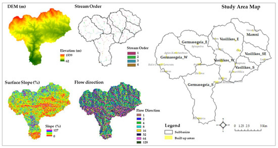
The study area that has been affected by the recent fire event of July 2021 in Cyprus is divided into eight (8) sub-basins (Figure 1, Table 1), and it is in the mountainous area between Limassol and Larnaca provinces. This widespread fire, which is considered the most destructive one in the history of Cyprus in terms of human and economic losses, shaped a new hydrological regime in the area, as around 3134 hectares of vegetation area were burnt. As presented in the map of Figure 1, the eight sub-basins are named according to the main river that they are drained by and their orientation. Thus, three sub-basins are drained by the Germasogeia River, three sub-basins are drained by the Vasilikos River and one sub-basin is drained by the Maroni River. The mean altitude and surface slope for the study area are 628 m and 30%, respectively, and the predominant land-cover types are coniferous forest and sclerophyllous vegetation, according to the available information provided by the CORINE Land Cover (2018) [6].

Figure 1.
Map of the study area.

Table 1.
Geomorphological characteristics of the eight sub-basins.
As the study area consists of ungauged basins, the hydrological analysis was performed using only open access datasets. Table 2 summarizes the datasets that were analyzed in a GIS environment, in order to create the necessary thematic layers as a basis for the hydrological analysis. Additionally, data regarding the available intensity-duration-frequency (IDF) curves from several meteorological stations that operate in the area were used as provided by [7]. Finally, data regarding soil type distribution, and other useful available geographical datasets were incorporated in the analysis, as listed in the same table.

Table 2.
Datasets.
3. Methodology
The methodological approach that was developed and applied for the eight sub-basins’ hydrological analysis involved: (i) unit hydrograph (UH) determination using the GIS-based time-area diagram (TAD) method [8,9] for both pre- and post-fire conditions, as well as (ii) the design storm hyetographs that were determined using the alternating block method (ABM) [10] for the two rainfall scenarios of 20- and 100-year return periods. The estimation of hydrological losses was calculated using the SCS-CN method for both scenarios. Thus, two indicative flood events were investigated through performing event-based rainfall-runoff simulations. The results were compared regarding total runoff volume, peak discharge, and time to peak for each sub-basin and for pre- and post-fire conditions.
3.1. TAD Method and UHs
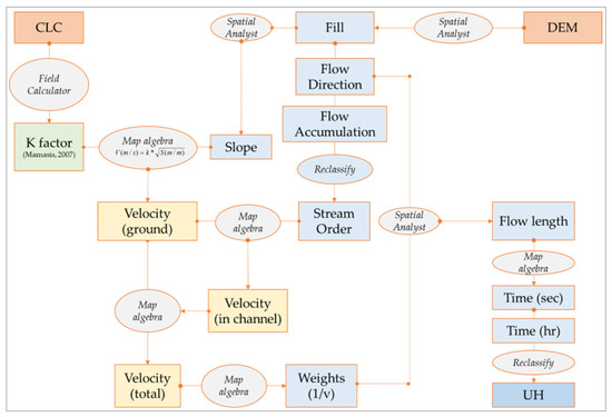
The development of the TAD method in a GIS environment requires the utilization of geographical data, such as the Digital Elevation Model (DEM), as the input terrain dataset, and a layer regarding land cover distribution [6], which is used for the Manning coefficient (K factor) determination. The K factor associated with the land-cover type is defined for both states (pre- and post-fire conditions). As shown in Figure 2, these datasets are involved in the calculation of the overland and in-channel flow velocities for each sub-basin, a dataset that is necessary for the determination of each cell’s runoff time to watershed outlet. Using the map algebra tool, a final raster dataset regarding isochronous curves is obtained, which is then re-classified to extract the TAD at a catchment-scale (Figure 3).

Figure 2.
GIS-based TAD method flowchart.

Figure 3.
Indicative layers in the GIS procedure.
3.2. ABM for Design Storm Hyetographs and SCS-CN Method for Hydrological Losses Estimation
Design hyetographs were calculated for two scenarios regarding return period (20 and 100 years) using the IDF curves in the given meteorological stations’ positions within the study area. The temporal distribution of rainfall was determined using the ABM and the hydrological losses were estimated with the SCS—CN method [11]. For the current study, the weighted (average) value of CN was determined for each sub-basin based on the land uses and hydrological soil type distribution. As shown in Table 3, the pre-fire values of CN are lower than the post-fire ones, since the latter are heavily dependent on the altered land uses corresponding to the burnt area.

Table 3.
Main hydrological characteristics of the flood hydrographs for each sub-basin.
4. Results and Discussion
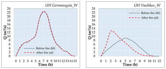
The determination of the UHs using a GIS-based approach for the TAD method development and for hydrological conditions prior to and after the fire event for each sub-basin (e.g., Figure 4), illustrates the fact that severe fire events affect a watershed’s hydrological response in many ways; they generally increase the peak discharge and reduce the time to peak. For reasons of comparison, indicative results are summarized in Table 3, while in the same table one can see that the values of CN used for the hydrological losses estimation also differ in accordance with the total burned area. In general, after this fire event, the value of CN is increased due to changes in land use. In the sub-basins of Vasilikos_W and Vasilikos_E, the highest values of CN are estimated, since these areas have the higher proportion of burnt area. As a result, for example, the sub-basin Vasilikos_W, with a 35% burnt area, presents a peak discharge of 28% higher compared to the pre-fire conditions, and a time to peak 60% lower than the one calculated before fire. On the other hand, sub-basins with a burnt area of 1–3% of the total area, such as the Germasogeia_W, Germasogeia_S and Vasilikos_S sub-basins, do not show any significant change in peak discharge and time to peak compared to the pre-fire conditions.

Figure 4.
Comparison in the UHs, as calculated for pre- and post-fire conditions, indicative for two sub-basins.
5. Concluding Remarks
This paper examines the hydrological response of eight sub-basins under both pre- and post-fire conditions. The hydrological analysis that is executed for the study area illustrates the systematic increase in the peak discharge and the total volume, and the reduction in the time to peak. We also highlight that the more burned areas there are, the stronger the influence in runoff increase will be. Our results underline the significant fire impact on hydrological response, since generally this land cover change increases the effective rain and the roughness coefficient and, consequently, the peak discharge and runoff volume, and further reduces the time to peak during a rainfall event. The fire impact could further increase flood risk in lowlands, as the downstream area is defined as of potentially significant flood risk even before the fire. For instance, in the Germasogeia River Basin, areas located downstream of the July 2021 fire-affected area have been already included in the areas of potentially significant flood risk, and the fact that the river has higher potential to cause flooding during the post-fire period should be taken into consideration. Generally, many parts of the fire-affected area are expected to be more susceptible to desertification, erosion, landslides and floods in the post-fire period. The need for re-assessment of their susceptibility is imperative. This analysis provides useful information for decision making in natural disasters’ prevention and management, and for re-designing flood and erosion works.
Author Contributions
Conceptualization, P.M. and E.F.; methodology, P.M. and E.F.; software, P.M.; validation, P.M., E.F., P.T.N. and E.V.; formal analysis, P.M.; investigation, P.M. and E.F.; resources, E.F.; data curation, P.M.; writing—original draft preparation, P.M.; writing—review and editing, E.F., P.T.N. and E.V.; visualization, P.M.; supervision, E.F. All authors have read and agreed to the published version of the manuscript.
Funding
This research received no external funding.
Data Availability Statement
Data associated with this research work are available from the corresponding author upon reasonable request.
Acknowledgments
This analysis is part of the MSc thesis of Maida. The corresponding author would like to acknowledge the Department of Meteorology for the provision of data regarding updated the intensity–duration–frequency curves for selected stations in Cyprus. The corresponding author would also like to thank the Bodossaki Foundation (Athens, Greece) for the postdoctoral scholarship for the project entitled «Spatial statistical Analysis of urban Flood Events for the integrated flood Risk management»—SAFER, in the frame of which the meteorological/hydrological data were acquired.
Conflicts of Interest
The authors declare no conflict of interest.
References
- Chaudhary, M.T.; Piracha, A. Natural Disasters—Origins, Impacts, Management. Encyclopedia 2021, 1, 1101–1131. [Google Scholar] [CrossRef]
- European Commission. Climate Change and Wildfires, JRC Research Centre. 2020. Available online: https://joint-research-centre.ec.europa.eu/system/files/2020-09/09_pesetaiv_wildfires_sc_august2020_en.pdf (accessed on 9 June 2023).
- Nalbantis, I.; Lymperopoulos, S. Assessment of Flood Frequency after Forest Fires in Small Ungauged Basins Based on Uncertain Measurements. Hydrol. Sci. J. 2012, 57, 52–72. [Google Scholar] [CrossRef]
- Folton, N.; Andréassian, V.; Duperray, R. Hydrological Impact of Forest-Fire from Paired-Catchment and Rainfall-Runoff Modelling Perspectives. Hydrol. Sci. J. 2015, 60, 1213–1224. [Google Scholar] [CrossRef]
- Batelis, S.C.; Nalbantis, I. A Multi-Model Multi-Scale Approach to Estimate the Impact of the 2007 Large-Scale Forest Fires in Peloponnese, Greece. Water 2022, 14, 3348. [Google Scholar] [CrossRef]
- CLC 2018—Copernicus Land Monitoring Service. Available online: https://land.copernicus.eu/pan-european/corine-land-cover/clc2018 (accessed on 1 June 2023).
- Feloni, E.; Baltas, E.; Anayiotos, A.; Michaelides, S. Assessment of the post-fire hydrological response in Cyprus using in situ and remotely sensed data. In Proceedings of the RSCy2023 Conference, Ayia Napa, Cyprus, 3–5 April 2023. [Google Scholar]
- Ross, C.N. The Calculation of Flood Discharges by the Use of a Time Contour Plan. Trans. Inst. Eng. Aust. 2020, 2, 85–92. [Google Scholar] [CrossRef]
- Beven, K. A History of the Concept of Time of Concentration. Hydrol. Earth Syst. Sci. 2020, 24, 2655–2670. [Google Scholar] [CrossRef]
- Chow, V.T. Applied Hydrology; Tata McGraw-Hill Education: New York, NY, USA, 2010; ISBN 978-0-07-070242-4. [Google Scholar]
- Soil Conservation Service. SCS National Engineering Handbook, Section 4: Hydrology; USDA: Washington, DC, USA, 1972. [Google Scholar]
Disclaimer/Publisher’s Note: The statements, opinions and data contained in all publications are solely those of the individual author(s) and contributor(s) and not of MDPI and/or the editor(s). MDPI and/or the editor(s) disclaim responsibility for any injury to people or property resulting from any ideas, methods, instructions or products referred to in the content. |
© 2023 by the authors. Licensee MDPI, Basel, Switzerland. This article is an open access article distributed under the terms and conditions of the Creative Commons Attribution (CC BY) license (https://creativecommons.org/licenses/by/4.0/).