1. Introduction
Two subjects pulled the author’s special attention as he started working as a forecaster in early 1970s, “the origin, structure and movement of the northwest Africa depressions” and the possible interaction between polar (PJS) and subtropical (SJS) jet streams. The main reasons for this were their strong questionable nature and their importance to the configuration of the weather conditions over the Balkans. This sort of jet interaction is something different from the well-known one contributing mainly to the rejuvenation of relatively low latitude origin depressions during northern hemisphere cold seasons, transforming them into vigorous extratropical systems. Many publications have appeared in the international meteorological literature, satisfactorily studying this atmospheric circulation phenomenon. Most of these papers are referenced in [
1], where the role of the coincidence of the right entrance region of a PJ stream with the left exit region of the SJS is stressed. An opportunity was given to the author to deal with the investigation of the North Africa depressions, leading to three papers [
2,
3,
4] revealing their baroclinic nature and also the way that they affect the weather in the Balkans and the neighboring countries. The research regarding North African cyclogenesis is continuing steadily, and many papers have appeared in the international meteorological literature up to the present day, certifying the findings of the abovementioned pioneering papers. These new papers utilize new terminology, changing the term “absolute vorticity advection” to “stratospheric intrusion of PV” without providing analyses of thermal (not dynamical) tropopause and maximum winds charts indicating the positions of its sharp folds, ignoring the fact that the sources of relative vorticity and PV are many and variable inside the troposphere. Maxima of PVs greater than the value of the dynamical tropopause should be examined more carefully before being characterized as “stratospheric intrusions”.
In addition, the possible interaction of the PJS and SJS in summer over Greece and its neighboring countries was investigated at the same time as the gathering of scientific findings presented in conferences and in journals cited in [
5]. Thus, in this short article, it is not necessary to repeat all of the findings resulting from the study of the atmospheric circulation conditions occurring when the subtropical jet stream (SJS) advances poleward far from its normal position, which is through Crete during summer. We will be restricted to mentioning the much more interesting and frequent phenomenon, because it is closely associated with the initiation of spells of Etesian winds outbreaks over the Aegean Sea [
5], which constitutes the so called ”ordinary wind regime over the Greek Seas and mainly the Aegean one in summer”. This finding refers to cases in which the SJS is situated over the Greek mainland. Then the frontal surfaces associated with the polar jet stream or a polar jet streak passing through Greece coming from the north cause severe weather in northern Greece as far south as Larisa (WMO 16648, 39.39° N, 22.26° E). Precipitation does not usually occur south of Larisa because the SJS constitutes a barrier to the southward extension of the upper half part of the cold frontal surface. The only atmopheric process in this case is cold advection in the lower troposphere, resulting in a temperature drop even in south Greece, with the simultaneous establishment of an Etesian winds outbreak, since the combination of the mobile dynamic anticyclone being positioned over the Balkans after the passage of the cold front, while the permanent Cyprus surface low is very active. The main task of this article is to present the weather which occurred from 7 to 10 July 2022, focusing at the same time on identifying how much this case differs from the abovementioned ordinary situation.
3. Results and Discussion
During the time period between 7 and 10 July 2022, the weather over almost all of Greece was particularly severe, with much precipitation and many thunderstorms. As this period falls in the Etesian winds season characterized by northeasterlies and synoptic scale atmospheric stability, as we have mentioned above, the phenomenon has been rare so far, but not unprecedented. The Etesian winds regime sometimes breaks down with the arrival of a low-pressure system over the central and southern Aegean Sea, which is advected, or more often created, by temporary cyclogenesis establishing southerly winds in its south and east sectors [
5]. We will attempt below to identify the physical processes which led to this kind of weather.
On 6 July, a low-index atmospheric circulation prevailed over the north Atlantic and Europe, with a significant wave train perturbation further north than 55° N showing signs of downstream development. The Azores’ high response to the planetary wave number 2 extended northward just west of the British Isles, and a particularly warm subtropical anticyclone settled over almost all of Europe. The permanent Persian summer trough influenced the MSL pressure as far as central Aegean Sea as usual. On the next day, the 7th of July, an anticyclonic breaking of the wave started just east of Britain and northwest Europe. This was a precursor of surface cyclogenesis over southeastern Europe [
6,
7]. Of course, nowadays this kind of precursor is not needed any more, as the ECMWF-IFS works successfully. For a better understanding of the evolution of the perturbation in question, see the brown contour labelled 5560–5564 gpm (
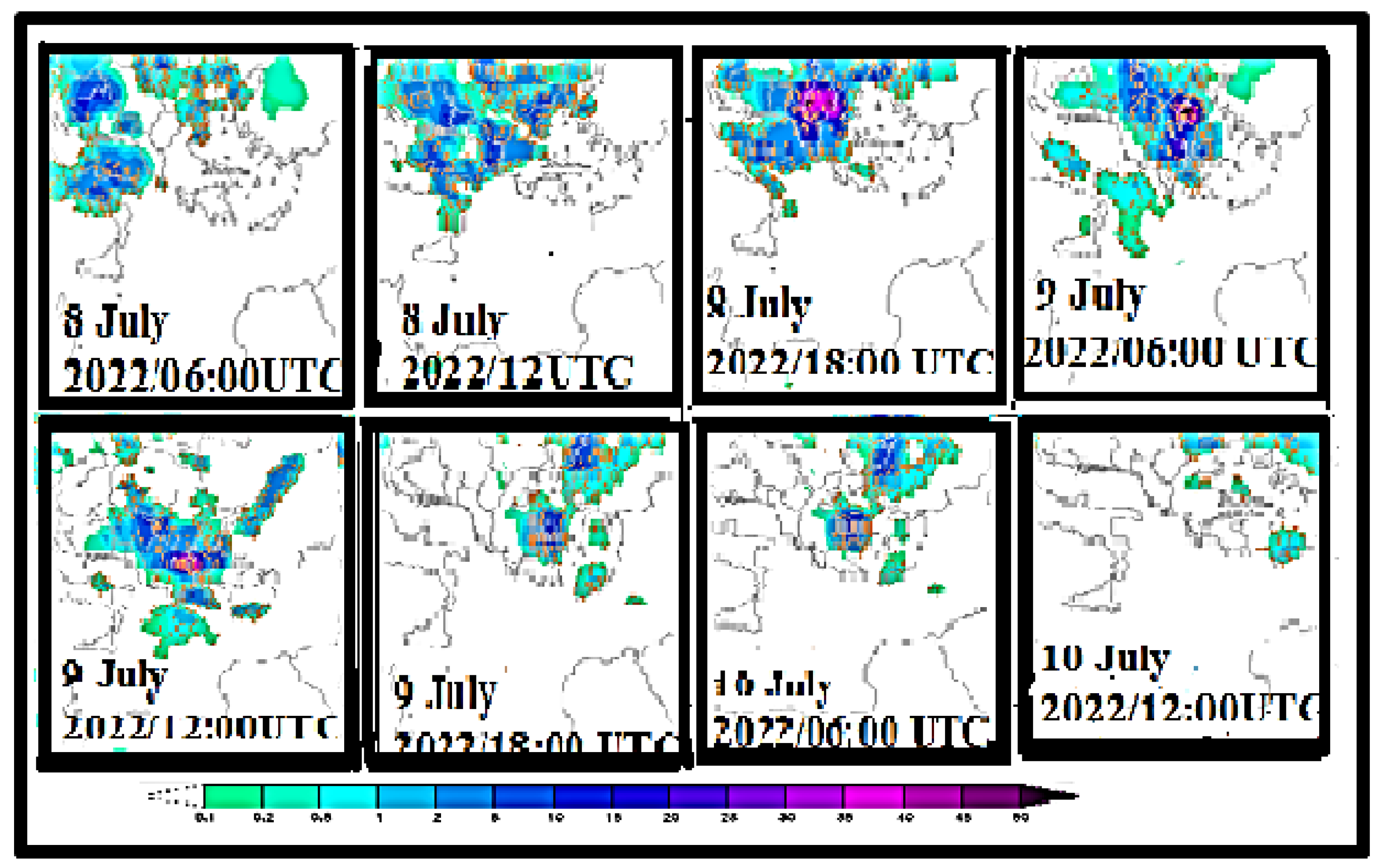
Figure 1). At the end of the day, a 500 hPa trough accompanied by a maximum of relative vorticity appeared just northwest of Greece, moving southward and influencing Italy and Greece. In the morning of 8 July, severe weather occurred (
Figure 2) over most of Italy and north-eastern Greece. The type of heavy precipitation, accompanied by strong electric phenomena, indicated the occurrence of deep convection over Italy and Greece, restricted to Greece over the last half of the considered period. The surface charts obtained from the National Meteorological Service of Italy (
www.meteoam.it, accesed on 10 July 2022) (
Figure 3a) depict a rather smooth low-pressure field over Greece, measured at 1004 hPa, clearly marking the group troughs and the face trough centers of the wave’s baroclinic perturbation at 500 hPa, and outside this, overall, fronts at the surface.
This fact leads to the inference that cold advection only in the upper troposphere above a uniform warm air mass destabilizes the stratification of the atmosphere, converting a great deal of total atmospheric energy to Convective Available Potential Energy (CAPE). The release of CAPE needs a trigger effect to raise the surface air parcels up to the Level of Free Convection (LFC). These trigger effects, lacking up-sliding frontal force, are a result of the Greek summer sun overheating the ground, mainly the mountains, at midday and the advection of relative vorticity both at night and during the day.
Figure 3b (source: “
www.resources.eumetrain.org/eport__MapViewer/index.html”, accessed on 22 July 2022) shows that the temperature at the 500 hPa level over Greece at NW of the Upper Level Front (ULFnt) seen over Chios Island is about −13 °C, while the southernmost part of the ULFnt has collapsed due mainly to adiabatic heating of the polar air mass under the SJS. CAPE values are greater than 1000 j/kg just north of Crete and lower at the rest of Greece. Stream lines show a closed low over the Greek mainland.
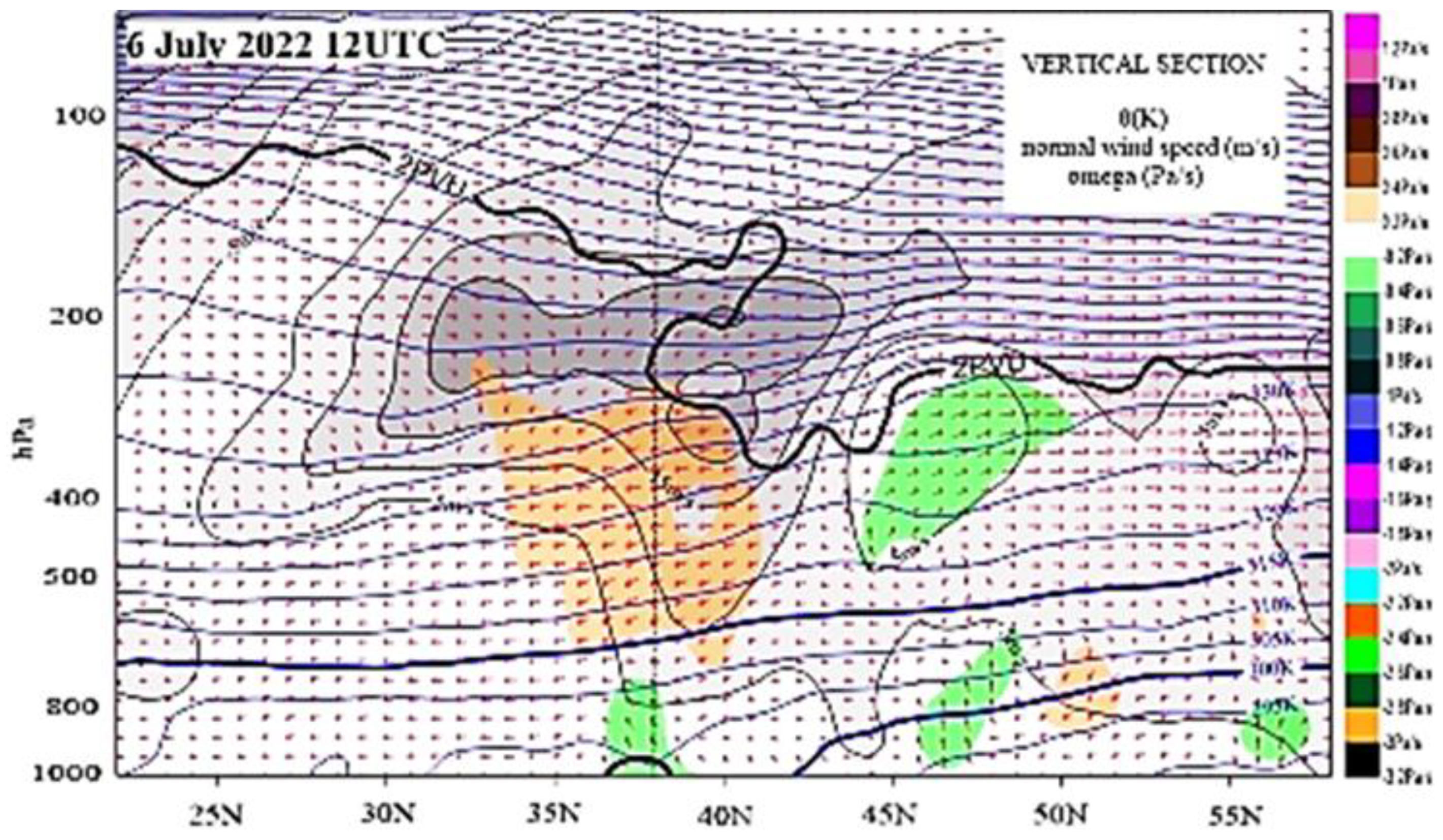
The whole development and evolution of the baroclinic perturbation from 6 to 10 July 2022, is clearly visible in the visualized cross-sections along 23° N meridian passing through Athens (
Figure 4 and
Figure 5). These cross-sections show the north–south variation of wind and temperature (θ) from 20° N to 60° N, where the interactions of the jet streams are better seen mainly along their height, certifying the weather conditions mentioned just above. On 6 July 2022, at 12:00 UTC, the location of SJS appears to be above 33° N at 200 hPa, extending northwards up to about 45° N (
Figure 4). The lowering of the dynamical tropopause and the parallel flow from the north already indicate the presence of a polar jet stream beneath the SJS, just south of 45° N. That is, the face trough of the polar jet stream is located between the brown and green areas of opposite vertical motion. On 7 July, at 12:00 UTC, the interaction between the two jet streams continues clearly resulting in the restriction of the SJS between 35° N and 40° N (
Figure 5a), whereas the polar one appears to be just north of Athens, just beneath the SJS. Over the two next days (
Figure 5b,c), the SJS core was concentrated over Crete Island (35° N), with the PJS advancing southward on 9 July. On these two days, the presence of PV valued at more than 2 PVU in the lower troposphere could contribute to triggering the release of the existing CAPE.
Figure 6 clearly shows the positions of the two jets, verifying
Figure 5c. Finally, since the maximum vorticity had passed the previous day, the rain over Crete on 10 July (
Figure 2) should be attributed to the release of CAPE due to overheating of the Cretan mountains under the Greek summer sun.
4. Concluding Remarks and Suggestions for Future Research
The analysis of weather conditions during the time period from 7 to 9 July 2022, reveals the superiority of mesoscale vertical motion against that of the synoptic scale. Although the ordinary interaction between the SJS and PJS functioned fairly well and the synoptic scale subsistence usually occurring equatorward of the SJS axis suppressed the upward motion of the same scale owing to the PJS, severe weather occurred in and over all of Greece. The combination of the warm air in the lower troposphere with the cold advection in the upper one created favorable conditions for CAPE generation. The release of this CAPE caused deep convection with mesoscale upward motion. This motion is much stronger than that of the synoptic scale. The ordinary interaction is characterized by the presence of a cold frontal surface being followed by a cold anticyclone, moving southward as a pair. This pair is missing in this case. The cold front did not appear at all, and the anticyclone was warm, weak, and far north from its ordinary position. Thus, in the case around 9 July 2022, despite demonstrating an interaction between the two jets, lacks most of the other basic characteristics that would mark it as ordinary. This is an exception. This case must drawn the interest of Greek climatologists, who have to study the phenomenon for more than 30 last years, indicating findings possibly associated with climate change and the appearing crisis.


