Next Article in Journal
Assessing the Impact of Aeolus Wind Profiles in WRF-Chem Model Dust Simulations in September 2021
Previous Article in Journal
The Effect of Apparent Temperature on All-Cause Mortality in England, UK
 
 
Please note that, as of 4 December 2024, Environmental Sciences Proceedings has been renamed to Environmental and Earth Sciences Proceedings and is now published here.
Proceeding Paper

Modelling Future Forest Fire Risk for the Tourism Sector of Crete †

by
Magdalini Tzouveleki
1,
Maria Hatzaki
1,*,
Varvara Antoniou
2,
Anna Karali
3 and
Christos Giannakopoulos
3
1
Laboratory of Climatology and Atmospheric Environment, Department of Geology and Geoenvironment, National and Kapodistrian University of Athens, 15784 Athens, Greece
2
Laboratory of Natural Hazards’ Management and Prevention, Department of Geology and Geoenvironment, National and Kapodistrian University of Athens, 15784 Athens, Greece
3
Institute for Environmental Research and Sustainable Development, National Observatory of Athens, 15236 Athens, Greece
*
Author to whom correspondence should be addressed.
Presented at the 16th International Conference on Meteorology, Climatology and Atmospheric Physics—COMECAP 2023, Athens, Greece, 25–29 September 2023.
Environ. Sci. Proc. 2023, 26(1), 150; https://doi.org/10.3390/environsciproc2023026150
Published: 1 September 2023

Abstract

:
Wildfires are one of the strongest drivers of degradation of Mediterranean ecosystems, while weather and climate are among the main factors influencing fire potential. From this perspective, we attempt to assess the future forest fire risk in Crete in the near (2046–2065) and distant future (2081–2100), under the Representative Concentration Pathways (RCPs) of RCP2.6, RCP4.5, and RCP8.5. A risk assessment model was developed according to the conceptual framework of the “impact chain”, as defined by the Intergovernmental Panel on Climate Change (IPCC), aiming at the formulation of a final composite risk index. The multicriteria spatial analysis, which was implemented with GIS techniques, highlighted the areas that are expected to be heavily affected in the future. It was found that the forest fire risk for the tourism sector increases with the higher emissions scenarios and towards the end of the century, with the south and central parts of the island exhibiting ‘very high’ risk. The effectiveness of this method is underlined, both in terms of implementing the necessary preventive measures against the adverse effects of climate change and of strengthening adaptation planning.

1. Introduction

Nowadays, the consequences of climate change are undoubtedly more evident than ever, as they affect ecological, social, and economic sustainability in various ways. In particular, the increasing frequency of fire incidents constitutes one of the most critical threats to continental and island ecosystems, while having a negative impact on different sectors of the economy, including tourism.
The Mediterranean is considered a high-fire risk region where fires cause severe environmental and economic losses and even loss of human lives. Weather and climate, vegetation conditions and composition, and human activities play an essential role in fire regimes [1]. Mediterranean forests are directly affected by the observed increase in temperature and drought levels, while evidence shows that the risk of fire is set to increase in the coming decades (e.g., [2]).
Crete is of particular interest from a climatological point, but also from an economic point of view, due to its geographical position in the Mediterranean basin and because of its highly touristic profile. The analysis conducted by WWF Greece and the Institute of Mediterranean Forest Ecosystems in 2011 about forest fires in Crete during the period 1983–2008 (http://www.oikoskopio.gr/pyroskopio/pdfs/pyrkagies-kriti.pdf, accessed on 11 July 2023), highlighted the criticality of the phenomenon and its effects. Specifically for Crete, the total area affected was estimated to be 751,949 ha, as a result of 2866 recorded fire incidents.
Thus, the scope of this work is the development of a standard methodological framework for assessing the level of risk of forest fires for tourism sector in the Region of Crete, which is expected to be directly affected by climate change.

2. Material and Methods

Risk-based climate change impact chain (IC) is a conceptual framework that allows integrating data from various disciplines (e.g., geography, climate modelling, stakeholders’ knowledge), methodological approaches, and sources, and follows a participatory approach to facilitate a better understanding and cross-cutting dialogue. Specifically, it is based on the combined use of qualitative and quantitative variables that fully describe the three components of risk, i.e., hazard, exposure, and vulnerability. It was implemented by the German corporation for International Cooperation (GIZ) [3]. Since then, ICs have been increasingly used as a climate risk assessment method, both for research purposes and decision making. Furthermore, it has been updated [4] for the understanding of climate change-related risks as proposed by the IPCC Fifth Assessment Report [5]. The risk results from the interaction of climate hazards, exposure, and vulnerability of the exposed elements, systems, and population. The IC development increases the usability of climate projections and climate impact models and can either involve a sophisticated modelling chain or support a quick diagnosis.
The three risk components are composed of several indicators. For the current study, the selected indicators can be seen in Figure 1. To set up the vulnerability and exposure indicators, we used land cover from CORINE Land Cover (2018) available via Copernicus Land Monitoring, protected areas from the World Database on Protected Areas (WDPA), and information for demographics and economics from the Hellenic Statistical Authority (Census 2011). Flammability per vegetation type was approached with the method proposed by [6].
For the hazard component, we used the Canadian Forest Fire Weather Index (FWI) being one of the most widely used systems [7] that assessed fire danger for research and operational purposes. The FWI has been shown to correlate well with fire activity globally and regionally [8,9,10,11]. Since 2007, the FWI has been adopted at the EU level by the European Forest Fire Information System (EFFIS), a component of the Copernicus Emergency Management Service (CEMS), to assess fire danger level in a harmonized way throughout Europe.
For the calculation of the FWI, we used three-hourly climatic output of air temperature, precipitation, wind speed, and relative humidity derived from three RCM/GCM pairs (ICHEC-EC-EARTH/RCA4, MPI-M-MPI-ESM-LR/RCA4, and MOHC-HadGEM2-ES/RCA4), developed within the EURO-CORDEX initiative (www.euro-cordex.net, accessed on 11 July 2023), for three periods [1986–2005 (reference), 2046–2065 (near future), and 2081–2100 (distant future)]. The future simulations were based on three RCPs, namely, RCP2.6, RCP4.5, and RCP8.5 [5].
The weighting of the indicators, sub-components, and components of the IC were based on experts’ opinions and calculated via the Analytic Hierarchical Process (AHP), a decision support method for multicriteria problems [12,13]. The application of the AHP aims to develop realistic models for more effective decision making on complex problems, taking into consideration quantitative and qualitative variables based on pairwise comparisons [14]. The AHP was performed via the Business Performance Management Singapore’s (BPMSG’s) AHP Online System (https://bpmsg.com/ahp/, accessed on 1 December 2022).

3. Results

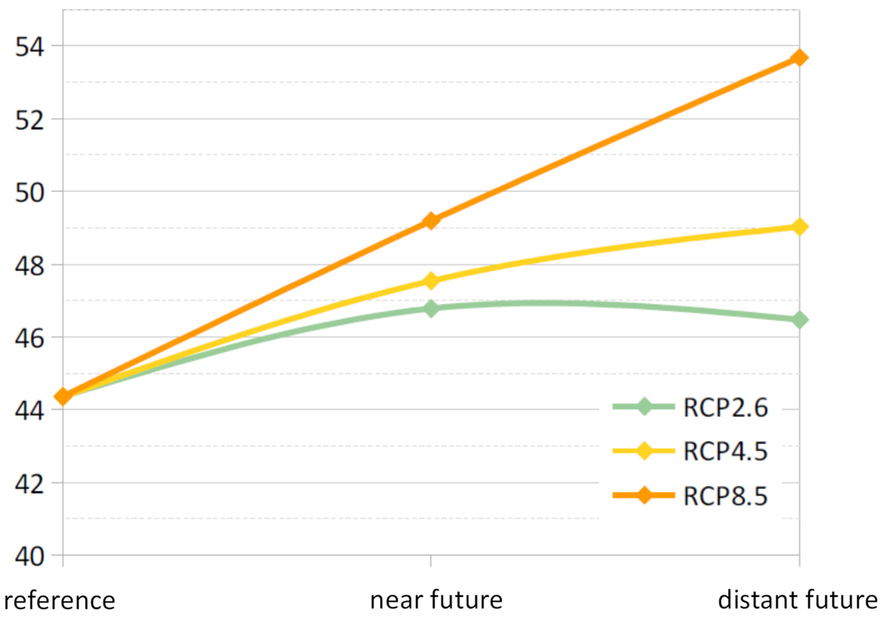
The application of the AHP on the IC, depicted in Figure 1, resulted in the hierarchical structure of the risk model and the respective weights of each indicator, sub-component, and component (not shown). It was found that the risk due to forest fires increases towards the end of the century for the two higher emission scenarios, while it slightly decreases under RCP2.5 (Figure 2). The risk was then classified into five levels: very low, low, medium, high, and very high, and the respective maps were created.
The risk levels for the Regional Units of Crete according to the lower emission (RCP2.6) and the higher emission (RCP8.5) scenarios and for the distant future (Figure 3) show that there is a transition from ‘medium’ to ‘high’ risk levels compared to the reference and near future periods (not shown). On the other hand, the ‘low’ risk areas are limited while ‘very low’ risk appears only in RCP2.6. The respective risk map (Figure 4) shows that a zone of ‘very high’ risk is found only in the Regional Unit of Heraklion and mainly in the southern coastal areas.

4. Conclusions

In this study, a risk assessment model was developed according to the conceptual framework of the impact chain and according to the methodology proposed by the German Agency for International Cooperation [4]. The multicriteria spatial analysis highlighted the areas that are expected to be heavily affected by forest fires due to climate change in the future.
Considering the results per period (1986–2005/2046–2065/2081–2100) and per future climate scenario (RCP2.6/RCP4.5/RCP8.5), we found that risk is expected to increase over time. According to the estimates under RCP8.5, the risk is expected to increase by 20% by the end of the century compared to the reference period (1986–2005), while under RCP2.6, fire risk returns at current climate levels.
The spatial analysis highlights the areas of the island under greater risk in terms of the occurrence of forest fire in the long term. These are primarily identified within the forest zones and areas of high flammability, mostly evident in the southern coastal area of Heraklion, which has the highest percentage of spatial coverage of ‘very high’ risk areas according to all emission scenarios, both in the near and the distant future. However, the ‘moderate’ risk is predominant over time throughout the Region of Crete. In summary, the results highlight the gradual expansion of the ‘high’ to ‘very high’ risk zones and at the same time the shrinking of the less critical areas.
We also demonstrate that the Analytical Hierarchical Process (AHP) is a particularly useful method and yields equally good results compared to the analysis applied in related studies [2]. However, the lack of availability of future data that compose exposure and vulnerability components poses limitations on the future risk assessment. The use of more accurate future data, derived from appropriate simulation procedures of future conditions, can contribute effectively to the optimal efficiency of the risk model.
In conclusion, the increased risk of forest fire occurrence will have a direct impact on the ‘blue’ economy, affecting the sustainable development of tourism on the island of Crete. The effectiveness of the developed model lies in the fact that it can contribute to the necessary preventive measures against the adverse effects of climate change and the strengthening of adaptation planning.

Author Contributions

Conceptualization, M.H., A.K. and C.G.; methodology, M.T., M.H., V.A., A.K. and C.G.; software, M.T.; validation, M.T. and M.H.; formal analysis, M.T. and M.H.; investigation, M.T. and M.H.; resources, V.A., A.K., C.G. and M.H.; data curation, M.T. and M.H.; writing—original draft preparation, M.T.; writing—review and editing, M.H., V.A, A.K. and C.G.; visualization, M.T.; supervision, M.H. All authors have read and agreed to the published version of the manuscript.

Funding

This research received no external funding.

Institutional Review Board Statement

Not applicable.

Informed Consent Statement

Not applicable.

Data Availability Statement

No new data were created.

Conflicts of Interest

The authors declare no conflict of interest.

References

  1. Costa, H.; De Rigo, D.; Libertà, G.; Houston Durrant, T.; San-Miguel-Ayanz, J. European Wildfire Danger and Vulnerability in a Changing Climate: Towards Integrating Risk Dimensions: JRC PESETA IV Project: Task 9-Forest Fires; Publications Office of the European Union: Brussels, Belgium, 2020.
  2. Bacciu, V.; Hatzaki, M.; Karali, A.; Cauchy, A.; Giannakopoulos, C.; Spano, D.; Briche, E. Investigating the Climate-Related Risk of Forest Fires for Mediterranean Islands’ Blue Economy. Sustainability 2021, 13, 10004. [Google Scholar] [CrossRef]
  3. Fritzsche, K.; Schneiderbauer, S.; Bubeck, P.; Kienberger, S.; Buth, M.; Zebisch, M.; Kahlenborn, W. The Vulnerability Sourcebook: Concept and Guidelines for Standardised Vulnerability Assessments; Deutsche Gesellschaft für Internationale Zusammenarbeit (GIZ) GmbH: Bonn, Germany, 2014. [Google Scholar]
  4. GIZ; EURA. Risk Supplement to the Vulnerability Sourcebook. Guidance on How to Apply the Vulnerability Sourcebook’s Approach with the New IPCC AR5 Concept of Climate Risk; GIZ: Bonn, Germany, 2017. [Google Scholar]
  5. The Intergovernmental Panel on Climate Change (IPCC). Climate Change 2014: Synthesis Report. Contribution of Working Groups I, II and III to the Fifth Assessment Report of the Intergovernmental Panel on Climate Change; IPCC: Geneva, Switzerland, 2014.
  6. Xanthopoulos, G.; Calfapietra, C.; Fernandes, P. Fire Hazard and Flammability of European Forest Types. In Post-Fire Management and Restoration of Southern European Forests; Moreira, F., Arianoutsou, M., Corona, P., De las Heras, J., Eds.; Springer: Dordrecht, The Netherlands, 2012; pp. 79–92. [Google Scholar] [CrossRef]
  7. Field, R.D.; Spessa, A.C.; Aziz, N.A.; Camia, A.; Cantin, A.; Carr, R.; de Groot, W.J.; Dowdy, A.J.; Flannigan, M.D.; Manomaiphiboon, K.; et al. Development of a Global Fire Weather Database. Nat. Hazards Earth Syst. Sci. 2015, 15, 1407–1423. [Google Scholar] [CrossRef]
  8. Abatzoglou, J.T.; Williams, A.P.; Boschetti, L.; Zubkova, M.; Kolden, C.A. Global patterns of interannual climate–fire relationships. Glob. Change Biol. 2018, 24, 5164–5175. [Google Scholar] [CrossRef] [PubMed]
  9. Bedia, J.; Golding, N.; Casanueva, A.; Iturbide, M.; Buontempo, C.; Gutiérrez, J.M. Seasonal predictions of Fire Weather Index: Paving the way for their operational applicability in Mediterranean Europe. Clim. Serv. 2018, 9, 101–110. [Google Scholar] [CrossRef]
  10. Dupuy, J.-l.; Fargeon, H.; Martin-StPaul, N.; Pimont, F.; Ruffault, J.; Guijarro, M.; Hernando, C.; Madrigal, J.; Fernandes, P. Climate change impact on future wildfire danger and activity in southern Europe: A review. Ann. For. Sci. 2020, 77, 35. [Google Scholar] [CrossRef]
  11. Karali, A.; Hatzaki, M.; Giannakopoulos, C.; Roussos, A.; Xanthopoulos, G.; Tenentes, V. Sensitivity and evaluation of current fire risk and future projections due to climate change: The case study of Greece. Nat. Hazards Earth Syst. Sci. 2014, 14, 143–153. [Google Scholar] [CrossRef]
  12. Saaty, T.L. The Analytic Hierarchy Process: Planning, Priority Setting, Resource Allocation; McGraw-Hill International Book Co.: New York, NY, USA; London, UK, 1980. [Google Scholar]
  13. Saaty, R.W. The analytic hierarchy process—What it is and how it is used. Math. Model. 1987, 9, 161–176. [Google Scholar] [CrossRef]
  14. Goepel, K.D. Implementation of an Online Software Tool for the Analytic Hierarchy Process (AHP-OS). Int. J. Anal. Hierarchy Process 2018, 10, 469–487. [Google Scholar] [CrossRef]
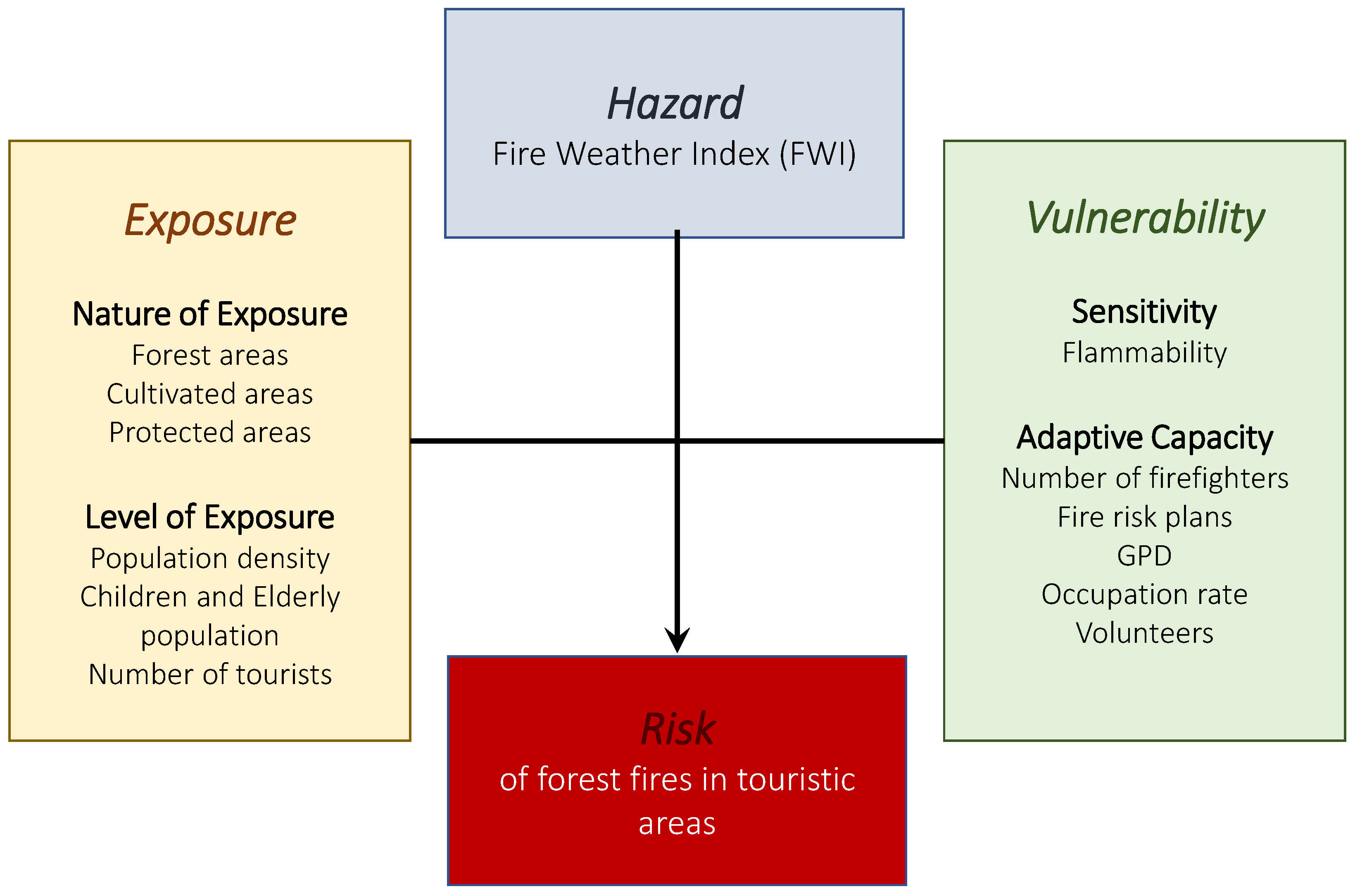
Figure 1. Structure of the impact chain with the selected indicators, according to the IPCC AR5 approach.
Environsciproc 26 00150 g001
Figure 2. Temporal evolution of risk, scaled from 0–100 (vertical axis), from the reference period to the distant future (horizontal axis) according to the three RCPs, averaged over the Region of Crete.
Environsciproc 26 00150 g002
Figure 3. Spatial coverage percentages of each risk level (from very low to very high) for each Regional Unit of Crete in the distant future (2081–2100) according to the RCP2.6 (left) and RCP8.5 (right) climate scenario, respectively.
Environsciproc 26 00150 g003
Figure 4. Risk map for the potential fire impact for Crete in the distant future (2081–2100) and under the RCP2.6 (left) and RCP8.5 (right) emission scenarios, respectively. The risk level from very low to very high is given by a color scale, i.e., from blue to red.
Environsciproc 26 00150 g004
Disclaimer/Publisher’s Note: The statements, opinions and data contained in all publications are solely those of the individual author(s) and contributor(s) and not of MDPI and/or the editor(s). MDPI and/or the editor(s) disclaim responsibility for any injury to people or property resulting from any ideas, methods, instructions or products referred to in the content.