Flood Vulnerability Mapping Using MaxEnt Machine Learning and Analytical Hierarchy Process (AHP) of Kamrup Metropolitan District, Assam †
Abstract
1. Introduction
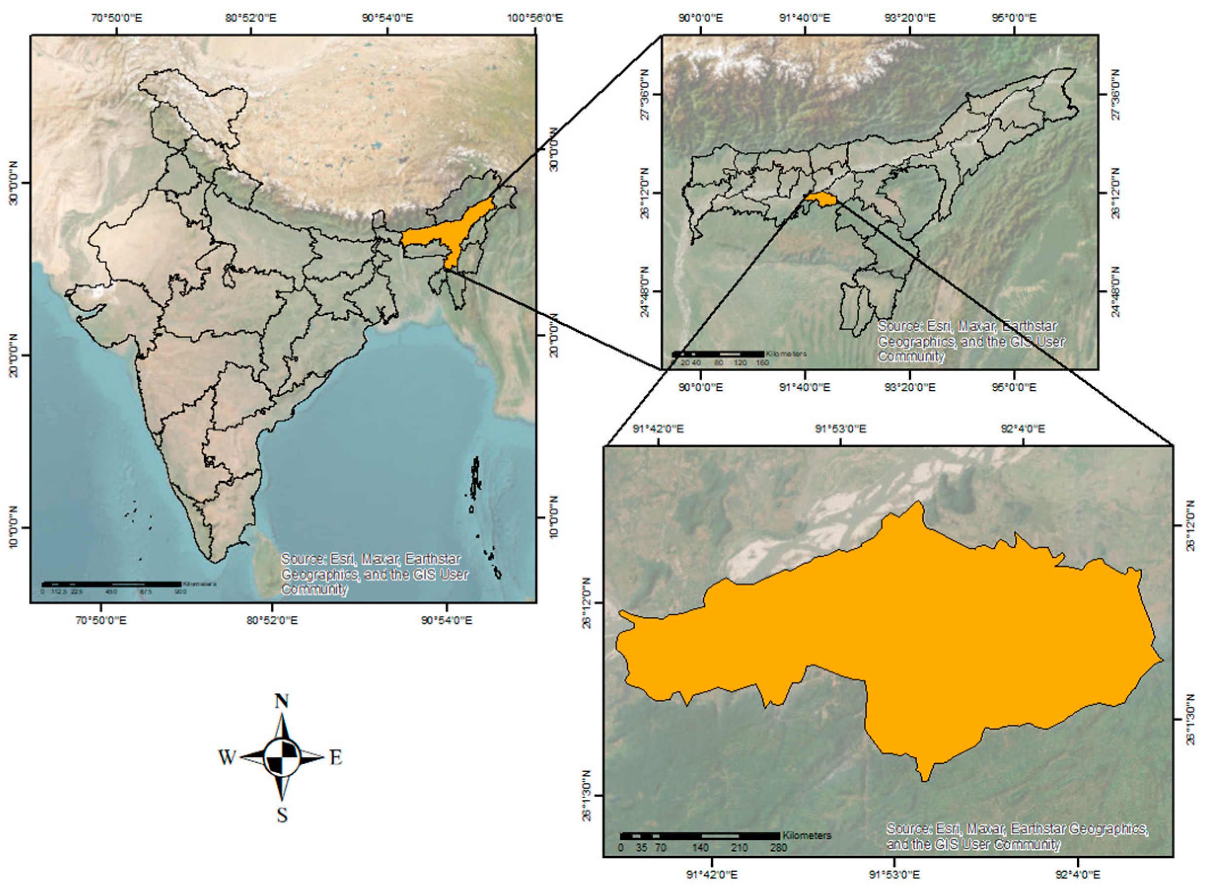
2. Study Area
3. Materials and Methods
3.1. Flood Inventory Mapping
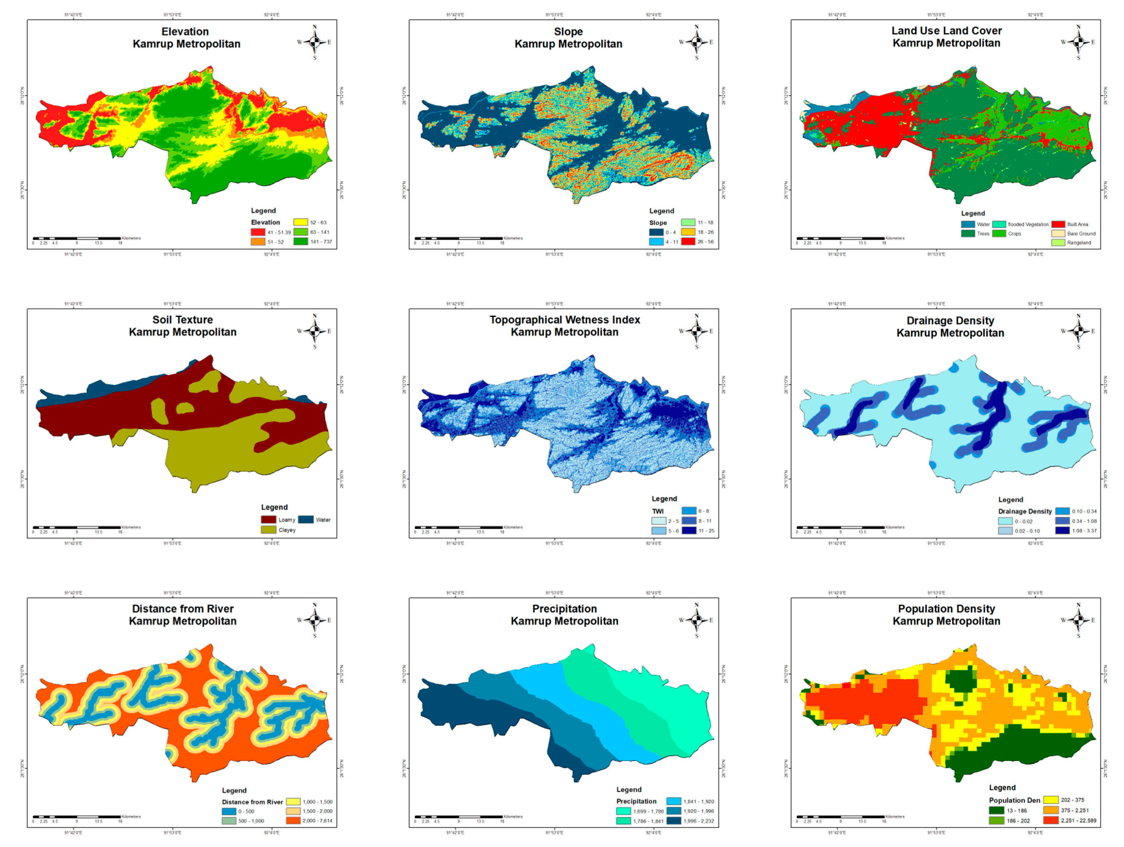
3.2. Flood Conditioning Factors
3.2.1. Elevation
3.2.2. Slope
3.2.3. Land Use Land Cover
3.2.4. Soil Texture
3.2.5. Topographic Wetness Index (TWI)
3.2.6. Distance from River Channel
3.2.7. Drainage Density
3.2.8. Rainfall
3.2.9. Population Density
4. Results
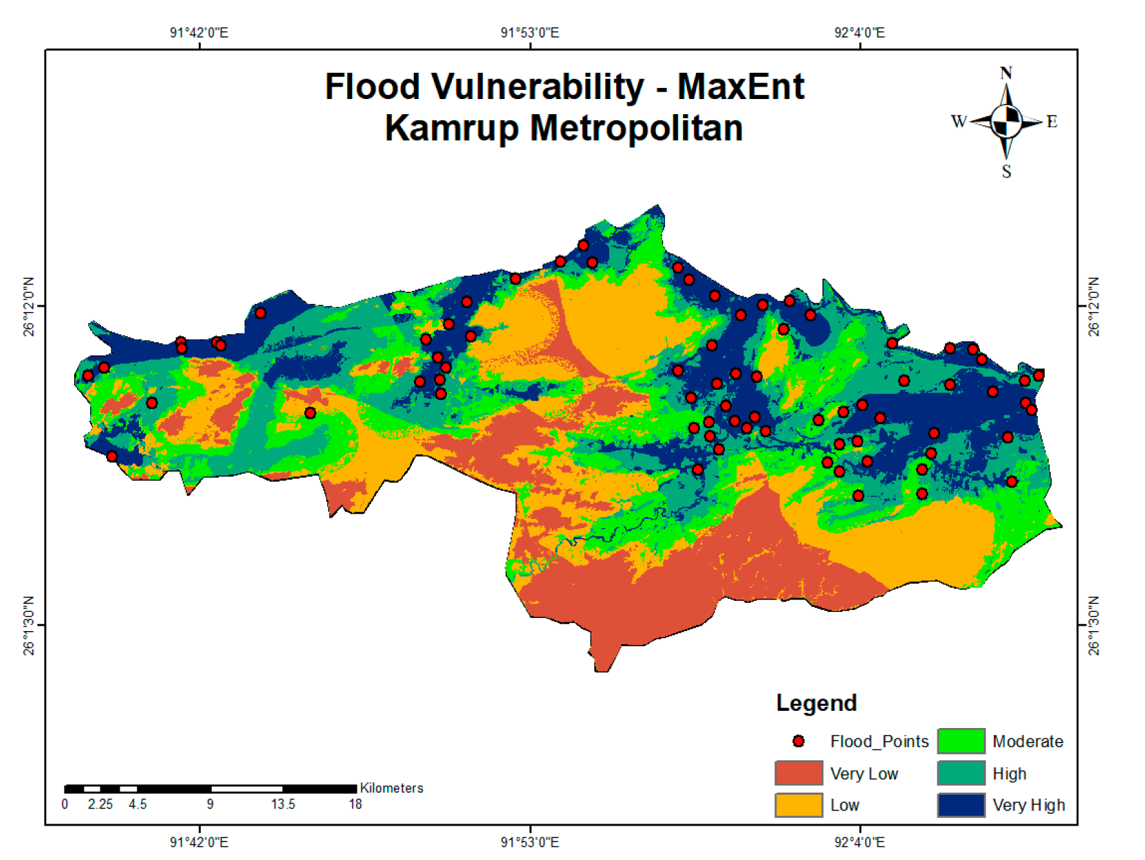
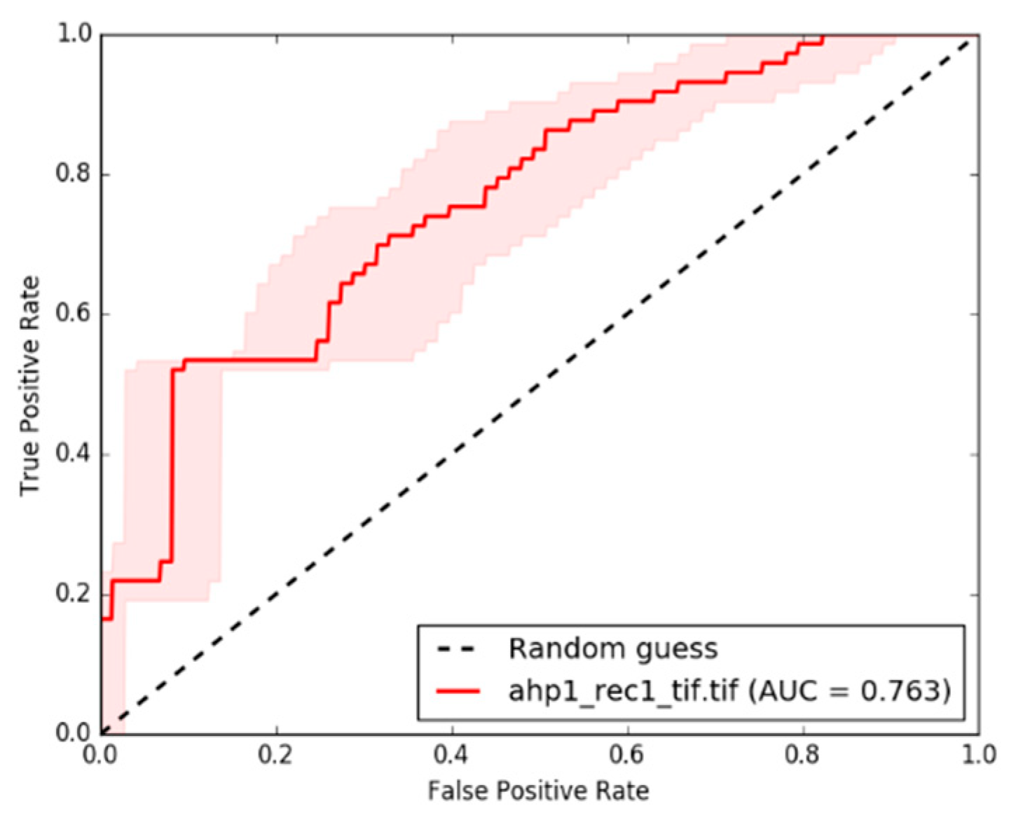
4.1. Maximum Entropy (MaxEnt)
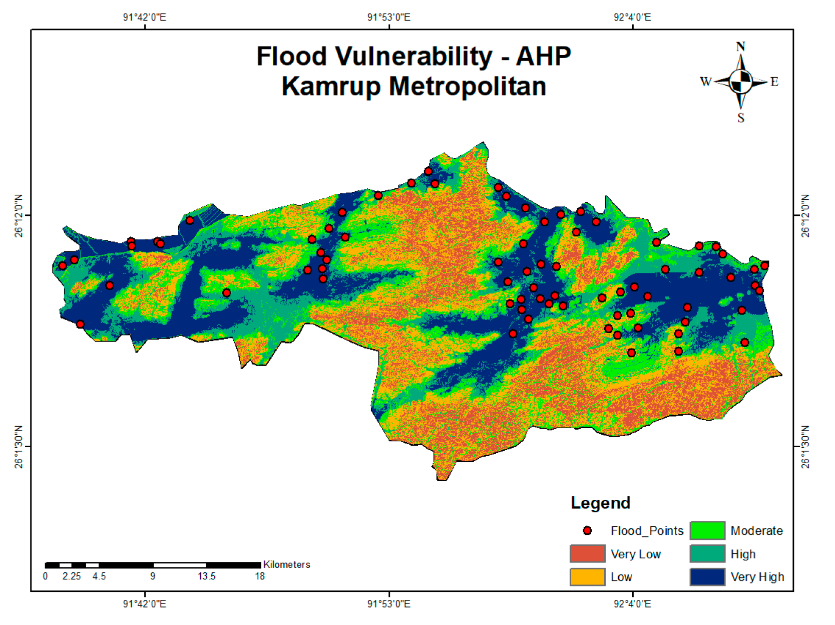
4.2. Analytical Hierarchy Process (AHP)
4.3. Comparative Analysis of sensitivity and Response Curves
4.4. Spatial Extent of Vulnerability
5. Conclusions
Author Contributions
Funding
Institutional Review Board Statement
Informed Consent Statement
Data Availability Statement
Conflicts of Interest
References
- Achour, Y.; Pourghasemi, H.R. How do machine learning techniques help in increasing accuracy of landslide susceptibility maps. Geosci. Front. 2020, 11, 871–883. [Google Scholar] [CrossRef]
- Arnaud, P.; Bouvier, C.; Cisneros, L.; Dominguez, R. Influence of rainfall spatial variability on food prediction. J. Hydrol. 2002, 260, 216–230. [Google Scholar] [CrossRef]
- Castillo, C.; Gómez, J.A. A century of gully erosion research: Urgency, complexity and studyapproaches. Earth-Sci. Rev. 2016, 160, 300–319. [Google Scholar] [CrossRef]
- Kelarestaghi, A.; Ahmadi, H. Landslide susceptibility analysis with a bivariate approach and GIS in Northern Iran. Arab. J. Geosci. 2009, 2, 95–101. [Google Scholar] [CrossRef]
- Kia, M.B.; Pirasteh, S.; Pradhan, B.; Mahmud, A.R.; Sulaiman WN, A.; Moradi, A. An artificial neural network model for food simulation using GIS: Johor River Basin Malaysia. Environ. Earth Sci. 2012, 67, 251–264. [Google Scholar] [CrossRef]
- Kornejady, A.; Ownegh, M.; Rahmati, O.; Bahremand, A. Landslide susceptibility assessment using three bivariate models considering the new topo-hydrological factor: HAND. Geocarto Int. 2018, 33, 1155–1185. [Google Scholar] [CrossRef]
- Pourghasemi, H.; Moradi, H.; Aghda, S.F.; Gokceoglu, C.; Pradhan, B. GIS-based landslide susceptibility mapping with probabilistic likelihood ratio and spatial multi-criteria evaluation models (North of Tehran, Iran). Arab. J. Geosci. 2014, 7, 1857–1878. [Google Scholar] [CrossRef]
- Rahmati, O.; Pourghasemi, H.R.; Melesse, A.M. Application of GIS-based data driven random forest and maximum entropy models for groundwater potential mapping: A case study at Mehran Region Iran. CATENA 2016, 137, 360–372. [Google Scholar] [CrossRef]
- Tehrany, M.S.; Pradhan, B.; Jebur, M.N. Flood susceptibility mapping using a novel ensemble weights-of-evidence and support vector machine models in GIS. J. Hydrol. 2014, 512, 332–343. [Google Scholar] [CrossRef]
- Conoscenti, C.; Rotigliano, E.; Cama, M.; Caraballo-Arias, N.A.; Lombardo, L.; Agnesi, V. Exploring the effect of absence selection on landslide susceptibility models: A case study in Sicily Italy. Geomorphology 2016, 261, 222–235. [Google Scholar] [CrossRef]
- Das, H.; Sonmez, H.; Gokceoglu, C.; Nefeslioglu, H. Infuence of seismic acceleration on landslide susceptibility maps: A case study from NE Turkey (the Kelkit Valley). Landslides 2013, 10, 433–454. [Google Scholar] [CrossRef]
- Jiménez-Perálvarez, J.; Irigaray, C.; El Hamdouni, R.; Chacón, J. Landslide- susceptibility mapping in a semi-arid mountain environment: An example from the southern slopes of Sierra Nevada (Granada, Spain). Bull. Eng. Geol. Environ. 2011, 70, 265–277. [Google Scholar] [CrossRef]
- Saponaro, A.; Pilz, M.; Wieland, M.; Bindi, D.; Moldobekov, B.; Parolai, S. Landslide susceptibility analysis in data-scarce regions: The case of Kyrgyzstan. Bull. Eng. Geol. Environ. 2015, 74, 1117–1136. [Google Scholar] [CrossRef]
- Jaafari, A.; Najaf, A.; Pourghasemi, H.; Rezaeian, J.; Sattarian, A. GIS-based frequency ratio and index of entropy models for landslide susceptibility assessment in the Caspian forest, northern Iran. Int. J. Environ. Sci. Technol. 2014, 11, 909–926. [Google Scholar] [CrossRef]
- Moore, I.D.; Grayson, R.B. Terrain-based catchment partitioning and runoff prediction using vector elevation data. Water Resour. Res. 1991, 27, 1177–1191. [Google Scholar] [CrossRef]
- Grabs, T.; Seibert, J.; Bishop, K.; Laudon, H. Modeling spatial patterns of saturated areas: A comparison of the topographic wetness index and a dynamic distributed model. J. Hydrol. 2009, 373, 15–23. [Google Scholar] [CrossRef]


| Factor | Weight |
|---|---|
| Slope | 0.22 |
| Distance from River channel in meter | 0.17 |
| Land use land cover | 0.05 |
| Soil Texture | 0.10 |
| Elevation | 0.07 |
| Rainfall in mm | 0.04 |
| Population Density | 0.02 |
| TWI | 0.21 |
| Drainage Density | 0.12 |
Disclaimer/Publisher’s Note: The statements, opinions and data contained in all publications are solely those of the individual author(s) and contributor(s) and not of MDPI and/or the editor(s). MDPI and/or the editor(s) disclaim responsibility for any injury to people or property resulting from any ideas, methods, instructions or products referred to in the content. |
© 2023 by the authors. Licensee MDPI, Basel, Switzerland. This article is an open access article distributed under the terms and conditions of the Creative Commons Attribution (CC BY) license (https://creativecommons.org/licenses/by/4.0/).
Share and Cite
Harshasimha, A.C.; Bhatt, C.M. Flood Vulnerability Mapping Using MaxEnt Machine Learning and Analytical Hierarchy Process (AHP) of Kamrup Metropolitan District, Assam. Environ. Sci. Proc. 2023, 25, 73. https://doi.org/10.3390/ECWS-7-14301
Harshasimha AC, Bhatt CM. Flood Vulnerability Mapping Using MaxEnt Machine Learning and Analytical Hierarchy Process (AHP) of Kamrup Metropolitan District, Assam. Environmental Sciences Proceedings. 2023; 25(1):73. https://doi.org/10.3390/ECWS-7-14301
Chicago/Turabian StyleHarshasimha, Akshayasimha Channarayapatna, and Chandra Mohan Bhatt. 2023. "Flood Vulnerability Mapping Using MaxEnt Machine Learning and Analytical Hierarchy Process (AHP) of Kamrup Metropolitan District, Assam" Environmental Sciences Proceedings 25, no. 1: 73. https://doi.org/10.3390/ECWS-7-14301
APA StyleHarshasimha, A. C., & Bhatt, C. M. (2023). Flood Vulnerability Mapping Using MaxEnt Machine Learning and Analytical Hierarchy Process (AHP) of Kamrup Metropolitan District, Assam. Environmental Sciences Proceedings, 25(1), 73. https://doi.org/10.3390/ECWS-7-14301


