Proceeding Paper

Evaluating the Impact of the Billion Tree Afforestation Project (BTAP) on Surface Water Flow in Tarbela Reservoir Using SWAT Model †

1
Green AI, Center of Precision Agriculture, PMAS Arid Agriculture University, Rawalpindi 46000, Pakistan
2
Department of Irrigation and Drainage, University of Agriculture Faisalabad, Faisalabad 38000, Pakistan
3
Department of Agricultural and Biological Engineering, University of California (UC Davis), Davis, CA 95616, USA
4
Department of Farm Machinery and Precision Engineering, Faculty of Agricultural Engineering and Technology, PMAS Arid Agricultural University, Rawalpindi 46000, Pakistan
5
Department of Structural Engineering, University of Agriculture Faisalabad, Faisalabad 38000, Pakistan
6
NCIB, Center of Precision Agriculture, PMAS Arid Agriculture University, Rawalpindi 46000, Pakistan
*
Author to whom correspondence should be addressed.
Presented at the 1st International Precision Agriculture Pakistan Conference 2022 (PAPC 2022)—Change the Culture of Agriculture, Rawalpindi, Pakistan, 22–24 September 2022.
Environ. Sci. Proc. 2022, 23(1), 23; https://doi.org/10.3390/environsciproc2022023023
Published: 26 December 2022

Abstract

:
Khyber Pakhtunkhwa launched the Billion Tree Afforestation Project (BTAP) in 2014. Pakistan also initiated a “10 billion trees in five years” project in 2018. The soil and water assessment tool (SWAT) model was used to forecast the impacts of LULC changes on water yield under three scenarios: before planting, after 1 billion trees planted, and after 10 billion trees planted. Model calibration and validation were undertaken at the Bisham Qila gauging station from 1984 to 2000 and 2001 to 2010. The Tarbela reservoir’s mean annual runoff declined from 53.70 mm to 45.40 mm after 1 billion trees planted, while under the third scenario it approximated 35.05 mm.

1. Introduction

Surface runoff with sediment is caused by erosion. Precipitation (snowfall and rain) and land cover affect soil erosion and runoff [1]. Urbanization increases runoff and sedimentation, reducing infiltration [2]. In the Tarbela reservoir, surface runoff has the greatest impact on sedimentation [3]. Land use change affects runoff and sediment flow. Khyber Pakhtunkhwa (KPK) launched the Billion Tree Afforestation Project (BTAP) in 2014 to meet the country’s water needs and to mitigate and adapt to climate change. On 3 September 2018, Pakistan’s prime minister announced the planting of 10 billion plants across the country, 3 billion of which will be planted in the upper Indus Basin. By 2024, 10 BTAP projects will be completed [4]. We hypothesized that BTAP plantations would reduce the Indus River surface water flow.
There have been no published studies that described the surface runoff at Tarbela reservoir after BTAP planting. We used the SWAT model to calculate the effect of LULC on streamflow. We used three LULC datasets to simulate the SWAT model. Before BTAP planting, stream flow was determined using LULC data. The second scenario used 1 billion trees’ LULC data. In the third scenario, LULC was used after 10 billion trees were planted.

2. Materials and Methods

2.1. Study Area

The study area was the Tarbela Dam drainage basin, one of Pakistan’s largest reservoirs [5]. Terbela Dam is situated at 34°05′23″ N and 72°41′54″ E on the Indus River in Haripur and Swabi. It is 143 m high [4].

2.2. SWAT Model

To simulate hydrological processes, SWAT needs climate variables, LULC, soil data, and river basin management [6]. SWAT can be discretized by grid or aggregated, in addition to HRU [7]. This study used HRU-based discretization. Figure 1 shows the method’s flowchart.

2.3. LULC Scenarios

In land use refinement, land use classes were updated according to changes in the study area, from barren to forest cover. After recreating HRU, the entire forest in the study area expanded as land use was updated. In scenarios 2 and 3, this tool changed barren land into forest. The second scenario was considered from after 1 billion trees were planted until 2017. In scenario 3, 10 billion trees will be planted by 2024, of which 3 billion will be in our study area [4]. In the second scenario, after planting 1 billion trees, 5% BARR land became 5% forest mixed, and in the third scenario, 13% barren land became 13% forest-mixed (FRST); these land use percentages were updated, respectively, in land use refinement.

3. Results

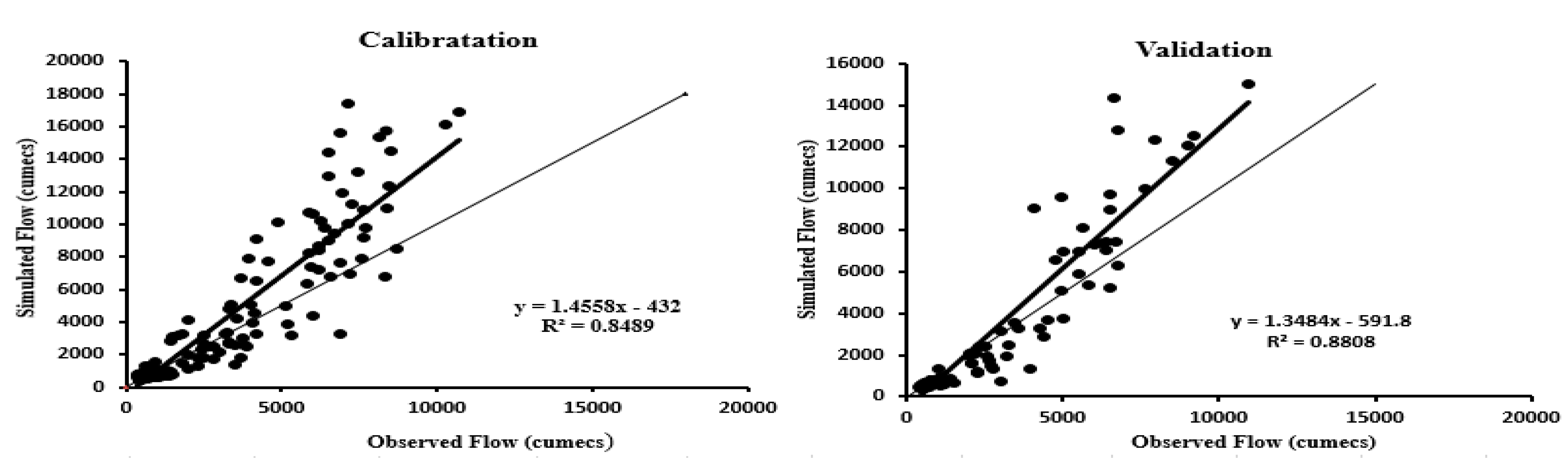
3.1. Calibration and Validation

In this study, calibration and validation of the SWAT model were done at Bisham Qila station. Monthly calibration occurred from 1984 to 2000, and monthly validation from 2001 to 2010. SWAT-CUP SUFI2 was used for calibration. The calibration results were promising, indicating a high model performance that can be used to examine land use and land cover effects on sediments and stream flow.
Figure 2 and Table 1 show the calibration and validation results. The calibration and validation values for R2, PBIAS, and NSE ranged from 0.84 to 0.88.

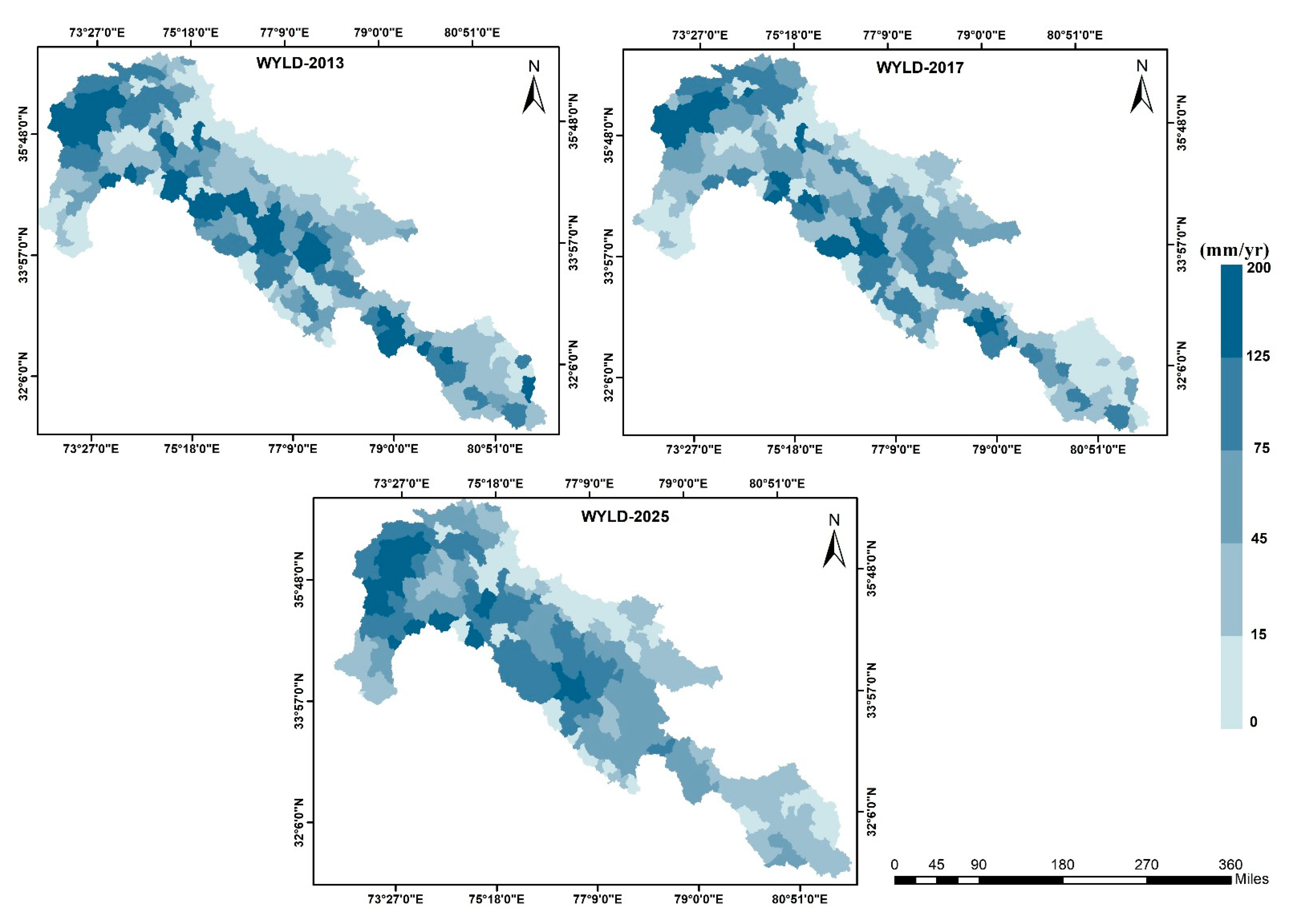
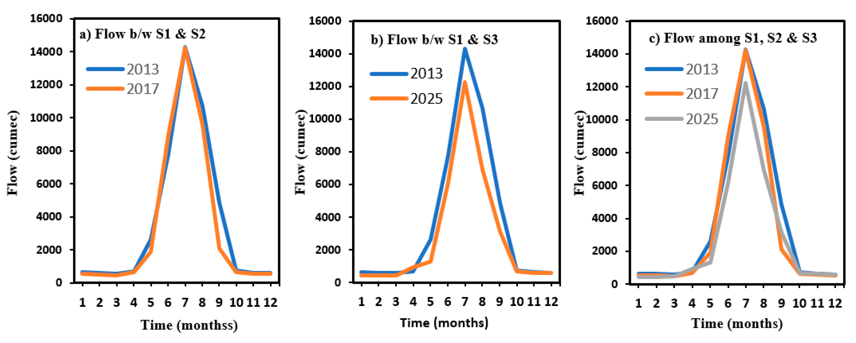
3.2. Impacts of BTAP on Water Yield

Figure 3 shows SWAT sub-basin water yields for 2013, 2017, and 2025. It includes model-developed water yield components. The first, second, and third sub-basin scenarios yielded 54 mm, 45 mm, and 35 mm of water annually, respectively.
Figure 4 shows the model results compared for accumulated water yield at the last sub-basin (300), an inlet of the Tarbela reservoir. After planting 1 billion trees, the peak monthly flow decreased from 14,300 m3/s (in 2013) to 14,225 m3/s (in 2017). After 10 billion trees planted, peak flow was reduced by 12,100 m3/s. Increased forestation from 2013 to 2017 reduced the annual flow by 18%. SWAT evaluation indicates that a 13% rise in forest cover would cause annual flows to drop by 26% from 2013 to 2025.

4. Conclusions

Simulations showed that increasing tree planting reduces water flow. A 3% increase in forest cover (after one billion trees) reduced reduce surface water flow by 18%, and a 13% increase (after three billion trees) reduced water flow by 26%, and sediment flow also reduced, respectively. The effect of BTAP on runoff shows that the Tarbela Dam area needs more forest cover. To stop runoff and sediment from getting into reservoirs, it is suggested that the Indus watershed be managed properly.

Author Contributions

Conceptualization, methodology, software, validation, A.B., A.S., and S.H.; formal analysis, S.S. and M.A.A.; investigation, A.S.; resources, A.B. and S.H.; data curation, A.B. and B.R.; writing—original draft preparation, A.B.; writing—review and editing, S.H. and M.A.H.K.; visualization, S.S.; supervision, A.S. and M.A.A.; project administration, S.H. and S.S. All authors have read and agreed to the published version of the manuscript.

Funding

This research received no external funding.

Institutional Review Board Statement

Not Applicable.

Informed Consent Statement

Not Applicable.

Data Availability Statement

Not Applicable.

Conflicts of Interest

The authors declare no conflict of interest.

References

  1. Salam, M.; Cheema, M.J.M.; Zhang, W.; Hussain, S.; Khan, A.; Bilal, M.; Zaman, M.A. Groundwater storage change estimation using grace satellite data in Indus Basin. Big Data Water Resour. Eng. (BDWRE) 2020, 1, 13–18. [Google Scholar] [CrossRef]
  2. Iqbal, M.M.; Li, L.; Hussain, S.; Lee, J.L.; Mumtaz, F.; Elbeltagi, A.; Dilawar, A. Analysis of Seasonal Variations in Surface Water Quality over Wet and Dry Regions. Water 2022, 14, 1058. [Google Scholar] [CrossRef]
  3. Dahri, Z.H.; Ahmad, B.; Leach, J.H.; Ahmad, S. Satellite-based snowcover distribution and associated snowmelt runoff modeling in Swat River Basin of Pakistan. Proc. Pak. Acad. Sci. 2011, 48, 19–32. [Google Scholar]
  4. Mirza, U.K.; Ahmad, N.; Majeed, T.; Harijan, K. Hydropower use in Pakistan: Past, present and future. Renew. Sustain. Energy Rev. 2008, 12, 1641–1651. [Google Scholar] [CrossRef]
  5. Getachew, H.E.; Melesse, A.M. The impact of land use change on the hydrology of the Angereb Watershed, Ethiopia. Int. J. Water Sci. 2012, 1. [Google Scholar] [CrossRef]
  6. Savvidou, E. A study of alternative Hydrological Response Units (HRU) Configurations in the Context of Geographical Information Systems (GIS)-Based Distributed Hydrological Modeling. Doctoral Dissertation, Department of Civil Engineering and Geoinformatics Engineering, School of Engineering and Technology, Cyprus University of Technology, Limassol, Cyprus, 2018. [Google Scholar]
  7. Shafeeque, M.; Sarwar, A.; Basit, A.; Mohamed, A.Z.; Rasheed, M.W.; Khan, M.U.; Sabir, R.M. Quantifying the Impact of the Billion Tree Afforestation Project (BTAP) on the Water Yield and Sediment Load in the Tarbela Reservoir of Pakistan Using the SWAT Model. Land 2022, 11, 1650. [Google Scholar] [CrossRef]
  8. Dilawar, A.; Chen, B.; Ashraf, A.; Alphonse, K.; Hussain, Y.; Ali, S.; Hussain, S. Development of a GIS based hazard, exposure, and vulnerability analyzing method for monitoring drought risk at Karachi, Pakistan. Geomat. Nat. Hazards Risk 2022, 13, 1700–1720. [Google Scholar] [CrossRef]
Figure 1. Workflow chart of methodology [8].
Environsciproc 23 00023 g001
Figure 2. SWAT model calibration and validation results.
Environsciproc 23 00023 g002
Figure 3. Spatial distribution of water yield for three scenarios (2013, 2017, and 2025) in sub-basins.
Environsciproc 23 00023 g003
Figure 4. Monthly stream flow comparison between first, second, and third scenarios.
Environsciproc 23 00023 g004
Table 1. The calibration and validation values.
Performance IndicatorCalibrationValidation (Water Yield)
R20.850.88
PBIAS11.29.4
NSE0.840.86
Disclaimer/Publisher’s Note: The statements, opinions and data contained in all publications are solely those of the individual author(s) and contributor(s) and not of MDPI and/or the editor(s). MDPI and/or the editor(s) disclaim responsibility for any injury to people or property resulting from any ideas, methods, instructions or products referred to in the content.

