Abstract
Contemporary water and environmental governance must address the diverse common objectives that have merged to target economic development, social equity, and environmental sustainability. Climate and land use changes, coupled with natural environmental hazards, generate immense and complex issues and challenges around the globe. Multilateral environmental agreements, the EU Water Framework and other directives, national policies and international conventions relevant to water and environmental governance indicate an ecosystem approach. With respect to disaster risk reduction, all the Sendai Framework priorities include ecosystems. The natural water retention capacity (hydrological ecosystem services) of river basins benefits from water/environmental governance and the disaster risk reduction perspective of selected environmental hazards is elaborated upon; the presented results underline the measures that improve river basin management and increase resilience to natural environmental hazards at selected river basins.
1. Introduction
The term ecosystem services (ESSs) emerged in the early 1980s [1], as a framework to shape the understanding of the benefits of the ecosystem processes for society. The Convention on Biological Diversity (CBD) [2] defines ecosystems (ES) as a dynamic complex of plant, animal and micro-organism communities and their non-living environment interacting as a functional unit. The European Environmental Agency (EEA) agreed on Europe’s wide list of ecosystem types feasible for data and information aggregation or disaggregation for the mapping and assessment of ecosystems and their services (MAES), as explained in detail in [3]. According to [4], ESSs are the benefits for people from ecosystems classified as regulatory (hydrological cycle and flow maintenance, flood protection, mass stabilization and erosion control, etc.), provisioning (surface and groundwater, etc.), and cultural by the Common International Classification of Ecosystem Services (CICES) [5].
The ES approach is recommended in the majority of multilateral environmental agreements (MEAs) [6,7] and EU Directives [8,9] relevant to integrated river basin management. At the European level, both EU member and non-member countries incorporate the EU Water Framework Directive (WFD) and EU Floods Directive (FD) objectives and requirements into their national law and are obliged to develop river basin management plans (RBMP) and flood risk management plans (FRMP) to support sustainable and integrated river basin management.
Based on the weather- and climate-related events information on economic losses and fatalities [10] evaluation of data and information synthesised from two databases, the analyses of the results from the CATDAT and NatCatSERVICE indicate that disasters from hydrometeorological and climatological events caused nearly 100,000 fatalities, affected more than 11 million people and resulted in total economic losses between EUR 450 and 520 billion from 1980 to 2020. Total losses were between 34 and 44%, 22 and 24%, respectively for hydrometeorological and climatological events.
The Sendai Framework for Disaster Risk Reduction, 2015–2030 (SFDRR) [11], as a global framework advocates a substantial reduction in disaster risk (DR) and loss to life, livelihoods and health in the economic, physical, social, cultural and environmental assets of persons, businesses, communities and countries. The ESSs’ functionality and contribution to disaster risk reduction (DRR) is included in all SFDRR documents and the consideration and incorporation of an integrated environmental and natural resources management approach is recommended. As elaborated in the following, the natural water retention measures applied in the integrated river basin management for the Danube and Tisza River Basins support water-related natural hazard DRR and the ecosystem-based disaster risk reduction (Eco-DRR) approaches. The number of water-related disasters and their consequences entails the identification of possible obstacles and issues for better interdependence in river basin and DRR management and ES incorporation that would enhance disaster risk reduction.
2. Integrated River Basin and Disaster Risk Management and Eco-DRR Synergies
2.1. Planning Framework
In Europe, the development of the RBMPs and FRMPs are elements of integrated river basin (the natural geographical and hydrological unit—instead of administrative or political boundaries) management developed in line with EU WFD and EU FD, respectively. Both plans incorporate management visions, objectives and measures for a 6-year planning period and are updated afterwards. DRR plans (DRRP) are elements of DR management (DRM) and are developed at the national, regional and local levels for natural hazards of interest (floods, droughts, earthquakes, etc.) for a selected spatial scale based on agreed scenarios and risk assessment. The DRRPs set out the goals and specific objectives for reducing disaster risks together with related actions to accomplish these objectives. They should be guided by the SFDRR and considered and coordinated within the relevant development plans, resource allocations and programme activities. “National-level plans need to be specific to each level of administrative responsibility and adapted to the different social and geographical circumstances that are present, e.g., disaster scenarios” [12].
In addition to risk assessment and cross-sectoral cooperation with respect to institutions, decision makers, stakeholders, and public participation are required for successful plan implementation as stipulated in the EU WFD, Flood Directive and Sendai Framework. The necessity for transboundary/international cooperation is emphasized for integrated water and disaster risk management.
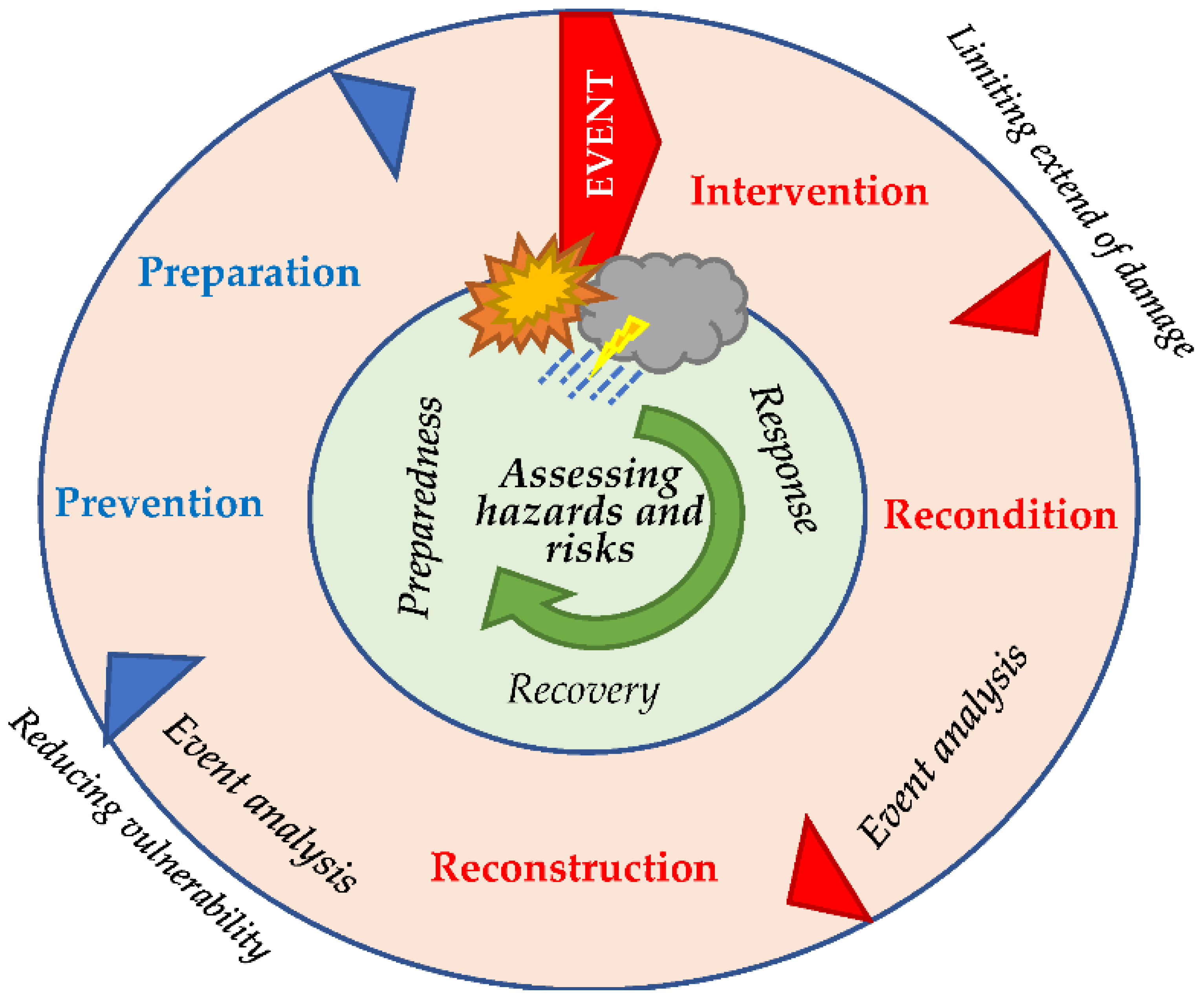
Common segments in the FRM and DRM preparedness, intervention (response), rehabilitation, recovery, and prevention, are based on the risk management cycle (Figure 1) with the main goal to reduce the risks and potential adverse consequences—disasters for human health, the environment, cultural heritage and economic activity. A similar approach is applied for river basin management planning DPSIR (driving forces, pressures, states, impacts, responses) framework with respect to significant river basin water management issues and the planning cycle.

Figure 1.
Risk management cycle (adapted from Integral Management Cycle, FOCP, 2003).
2.2. Spatial Scale
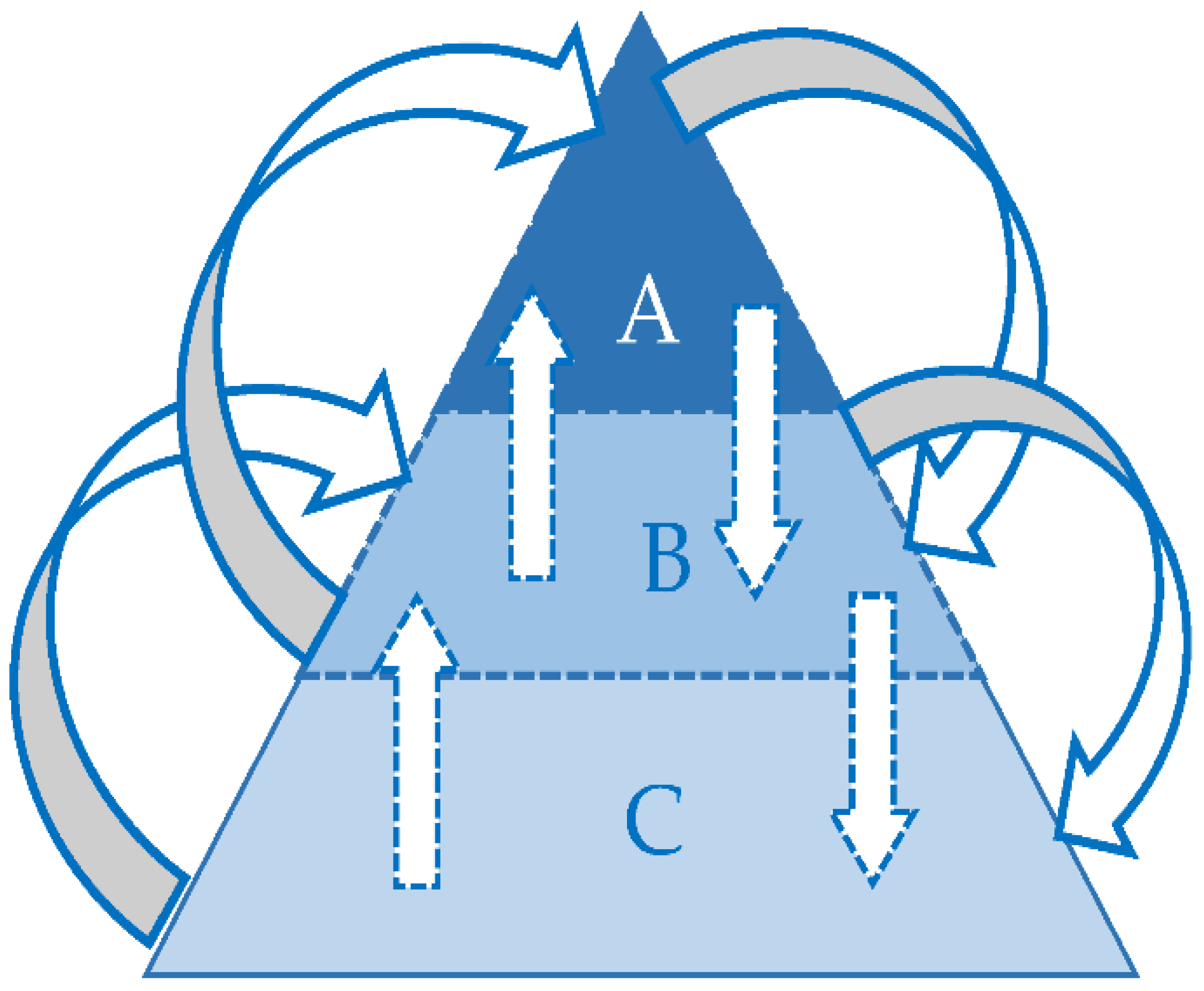
The most effective approach for water management is at the level of the river basin, sub-basin, and river district—the natural geographical and hydrological units—instead of administrative or political boundaries. River basin district means the area of land and sea made up of one or more neighbouring river basins, together with their associated groundwaters and coastal waters, which is identified under EU WFD Article 3(1) as the main unit for river basin management. The Danube River Basin (DRB) is the world’s most international river basin, shared by 19 countries. Integrated water management concepts within the DRB and cooperation among the Danube countries are implemented within the auspices of the International Commission for the Protection of the Danube River (ICPDR), based on the Convention on Cooperation for the Protection and Sustainable use of the Danube River (Danube River Protection Convention, 1998). The Danube River Protection Convention (DRPC) forms the overall legal instrument for co-operation on transboundary water management in the Danube River Basin. As a result, the Danube countries developed the Danube River Basin Management Plan (DRBMP) [13] and the Danube FRMP (DFRMP) [14] plans that are updated every 6 years (planning period) and include measures to address pressures and risks for strategic objectives and visions in line with EU WFD and EU FD. The reported measures (implemented and planned) are based on the Danube countries’ official water management planning documents and have relevance for the whole DRB water management in line with criteria listed in the DRBMP and DFRMP. The planning levels at the spatial scale are divided into A (Danube River Basin-DRB), B (DRB sub-basins—main tributaries e.g., Sava, Tisza, etc.) and C (river basin districts- national level) planning levels. Figure 2 presents the planning level spatial scales applied.
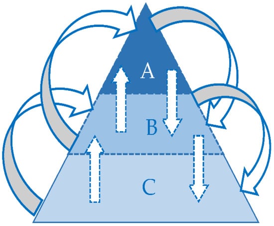
Figure 2.
DRB spatial scale water management planning levels schematics, developed by authors based on [8].
At the national and local levels, the strengthening of DRR governance to manage DR requires adaptation and implementation of the national and local disaster risk reduction strategies and plans, across different timescales, with targets, indicators and time frames, aimed at preventing the creation of risk, the reduction of existing risk and the strengthening of economic, social, health and environmental resilience [11] among the other tasks proposed in the SFDRR priority area 2. DRRM (disaster risk reduction management) plans are updated periodically and developed at the administrative level (local or regional and national). Cooperation and coordination at the international level are defined and organized based on bilateral agreements and international organizations.
2.3. Environmental Hazards and Solutions Inspired by Nature
The EU research and innovation policy agenda on nature-based solutions (NBS) and re-naturing Cities defines nature-based solutions to societal challenges as “solutions that are inspired and supported by nature, which are cost-effective, simultaneously provide environmental, social and economic benefits and help build resilience”. Such solutions bring more and more diverse nature and natural features and processes into cities, landscapes and seascapes, through locally adapted, resource-efficient and systemic interventions [15].
Ecosystem preservation, restoration and their services are the key for successful NBS implementation in urban and rural areas. There have been many projects at the global and EU level that have evaluated, analyzed and implemented NBS in recent years, resulting from the use of nature and natural processes to provide multifunctional and integrated solutions to many of the challenges human society is facing. Many of the existing concepts similar to NBS have multifunctional benefits and are considered as integrated solutions. A significant factor in the reduction of societies and countries’ adaptive capacity to reduce disaster risks is environmental degradation as highlighted in the last decade’s policy documents [15].
3. Eco-DRR, Natural Water Retention Measures (NWRMs) and Floods
In management planning for risks generated by water-related natural hazards, the ecosystem approaches that support DRR and natural water retention capacity are of great importance. Both concepts provide multifunctional benefits, have the potential to reduce environmental hazards and can contribute to climate change adaptation. They can increase grey infrastructure efficiency by their integration with existing and foreseen facilities.
Eco-DRR is the “sustainable management, conservation and restoration of ecosystems to reduce disaster risk, with the aim of achieving sustainable and resilient development” [16]. It supports DRRM for a number of natural hazards, e.g., floods, mass movement, droughts, flash floods, torrents, etc. “Natural Water Retention Measures (NWRMs) are multifunctional measures that aim to protect and manage water resources and address water-related challenges by restoring or maintaining ecosystems as well as natural features and processes with main focus to enhance water retention capacity of aquifers, soils and ecosystems” [17]. Their potential to provide multifunctional benefits include flood- and drought-risk reduction, the improvement of water quality, and habitat improvement, among others. Their implementation supports green infrastructure, preserves or improves water bodies’ quantitative status and can positively affect their status, and can contribute to climate change adaptation and mitigation.
3.1. Danube River Basin—NWRM Support to Ecological Hazards Resilience
The rationale and support for EU WFD and EU FD integration and the importance of the two processes’ coordination and synergy are provided in [13,14,18]. Natural phenomena such as floods, droughts, and heavy rainfall are uncertain and cannot be prevented. The risks of natural hazards are managed by measures to avoid disasters during emergency situations. Natural water retention capacity from the hydrologic response unit to basin level scale support both EU WFD and EU FD objectives. With respect to the latter, the NWRMs reported by the Danube countries are included in the DFRMP, 2021 (Annex 2). These measures support EU WFD environmental objectives, require a multidisciplinary approach and horizontal and vertical coordination, between the sectors and stakeholders and from local to national level. High probability floods have environmental benefits (groundwater recharge) and the NWRM contribution to holistic drought management should be underlined.
3.2. Integrated Tisza River Basin Management Plan (ITRBMP)—NWRMs for Environmental and Flood Risk Objectives Synergy
The Tisza River Basin (TRB) is the largest DRB sub-basin, shared by five Tisza countries. In comparison to DRBM, there is an additional water management issue identified by the ICPDR Tisza group to the TRB—water quantity and water quality inter-linkage and key water quantity management issues: floods and excess water, droughts and water scarcity, and climate change. Secondly, the ITRBMP integrates FRMP objectives and measures. The data and information included in the plan provided by Tisza countries follow ICPDR procedures and the Memorandum of Understanding for the TRB. In addition to FRM measures, the ITRBMP Update, 2019, incorporates “win-win” measures that support EU WFD environmental objectives for flood risk management within the TRB. The identified “win-win” measures in the ITRBMP Update, 2019, are elaborated with respect to the field of action and category to emphasize the NWRM concept within the TRB [18]. All 38 NWRMs are in the prevention field of action; for some of them, an urban or rural area for implementation is indicated, while others are applicable at the catchment-level scale or basin-level scale to improve retention capacity by increasing the safety of existing large dams—the attenuation of reservoirs capacity towards a projected one.
4. Discussion
A solution based on the ESSs’ concept for water-related natural hazard mitigation decreases risks, vulnerability and exposure by regulating the natural phenomena extremes. By providing benefits for human society, these services also prevent environmental degradation. This approach is not new: the application of measures for improved ESSs is well documented through centuries around the globe. They are characterized by a multibenefit, multidisciplinary approach and require political support at the national level for successful implementation at the local/regional level. For both concepts (RBM and DRM) with respect to planning processes, the coordination of activities by various sectors, and stakeholders, along with effective vertical and horizontal cooperation is required. With respect to Eco-DRR and NWRMs for flood risk management, they are more suitable for high probability events and both concepts should be integrated with existing and planned grey infrastructure to increase their level of service for medium and low probability events. Based on [19], for six case studies hazards were mitigated by measures categorized as NWRMs and elaborated in [14,18], e.g., deforestation, polders, etc. The lack of political support and scepticism among practitioners excluded from measures selection and implementation, have been identified for some case studies.
On the other hand, for flood risk management, NWRMs are based on national official data and address basin-level scale risks. Eco-DRR efficiency is still uncertain and design criteria are not well documented, while for the NWRMs, these data and information are better structured and supported. Based on [14], the NWRMs support flood risk management objectives with respect to the avoidance of new risks, reducing new risks, and solidarity principles for the prevention and protection aspects of FRM.
Comparison of RBFRM and DRR plans indicates the development of maps, the use of tools and various software. Plans are developed based on risks, vulnerability and exposure assessment and the resulting measures are proposed based on it. It is not possible to conclude to what extent measures based on ecosystem services, i.e., the Eco-DRR approach are integrated into the DRRM plans that are developed at the administrative boundaries level. It is very likely that better overlapping of the existing plans that are addressing water-related hazards will generate increased security for society and the environment. In a participatory approach with the local population involved in ecosystem-based planning processes, better results and efficiency should be generated. There are a number of concepts with different names and similar targets that support the ecosystem approach; this might generate confusion among practitioners and the general public. Water-related natural hazards are addressed by both ecosystem concepts addressed in this paper. Given the nature and spatial distribution of water-related natural hazards, the DRRM plan development should be based on the natural geographical and hydrological unit—instead of administrative or political boundaries—at least for high risk areas prone to disaster. FRM awareness-raising measures might disseminate to the general public information on the ecosystem services’ benefits and constraints (with respect to probability, maintenance, and downstream influence) for natural hazard management and disaster risk reduction. With no intention of favouring any concept or definition based on ecosystem services, the data and information presented indicate that Eco-DRR and NWRM have synergies and the same goals. There are better-documented data and information available for NWRM benefits (e.g., hydrology based), so Eco-DRR based on this concept would very likely increase natural hazard resilience within the natural geographical and hydrological units.
5. Conclusions
Interaction between the two ecosystem services concepts and objectives that support resilience to water-related natural hazards is indicated for the river basin management of selected river basins. Both integrated river basin and DRR management planning are multidisciplinary and iterative, based on effective cross-sectoral cooperation, diverse stakeholders’ interactions, participatory approaches, and the periodical update of plans. A different spatial dimension for plans might be reconsidered to allow better map, data and information overlap for more effective DRR management, due to the nature of water-driven natural hazards—they do not recognize administrative borders. Different definitions and concepts (Eco-DRR, NWRMs, nature-based solutions—NbS, ecosystem-based adaptation—EbA, etc.) based on ecosystems and their services and benefits might result in a low level of acceptance among practitioners and the general public, combined with confusing statements that this is a new approach, although the majority of measures have all been implemented for centuries around the world at the local level. In some publications, they are advocated as the wizard stick, with no clear message on constraints with respect to low-probability events, land ownership, potential space limits in urban areas, etc. This might increase scepticism and rejection among the stakeholders and decision-makers, despite the great number of benefits that are evident. With respect to low probability events, the Eco-DRR concept should be considered only as support for grey infrastructure. More research and better monitoring of the already applied ecosystem-based approach will increase their integration into policies at the national level and acceptance by practitioners.
Author Contributions
Conceptualization, B.B.M. and B.K.; methodology, B.B.M. and B.K.; formal analysis, B.B.M. and B.K.; investigation, B.B.M. and B.K.; resources, B.B.M. and B.K.; writing, B.B.M. and B.K.; project administration, B.B.M. and B.K.; funding acquisition, B.B.M. and B.K. All authors have read and agreed to the published version of the manuscript.
Funding
This research and publication of this article was funded by the University of Rijeka within projects “Implementation of Innovative Methodologies, Approaches and Tools for Sustainable River Basin Management” (UNIRI-TEHNIC-18-129) and “Hydrology of Water Resources and Identification of Flood and Mudflow Risk in Karst” (UNIRI-TEHNIC-18-54).
Conflicts of Interest
The authors declare no conflict of interest.
References
- Mooney, H.; Ehrlich, P. Ecosystem services: A fragmentary history. In Nature’s Services. Societal Dependence on Natural Ecosystems; Daily, G., Ed.; Island Press: Washington, DC, USA, 1997. [Google Scholar]
- Convention on Biological Diversity (CBD, UN, 1992). Available online: https://www.cbd.int/doc/legal/cbd-en.pdf (accessed on 26 January 2022).
- Maes, J.; Teller, A.; Erhard, M.; Liquete, C.; Braat, L.; Berry, P.; Bidoglio, G. Mapping and Assessment of Ecosystems and their Services. An Analytical Framework for Ecosystem Assessments under Action 5 of the EU Biodiversity Strategy to 2020; Publications office of the European Union: Luxembourg, 2013. [Google Scholar]
- Millennium Ecosystem Assessment (Program). Ecosystems and Human Well-Being; Island Press: Washington, DC, USA, 2005. [Google Scholar]
- Haines-Young, R.; Potschin, M.B. Common International Classification of Ecosystem Services (CICES) V5.1 and Guidance on the Application of the Revised Structure. 2018. Available online: https://cices.eu/resources/ (accessed on 26 January 2022).
- Convention on Cooperation for the Protection and Sustainable Use of the Danube River (Danube River Basin Convention (1998)). Available online: https://www.icpdr.org/flowpaper/viewer/default/files/DRPC%20English%20ver.pdf (accessed on 26 January 2022).
- Convention on the Protection and Use of Transboundary Watercourses and International Lakes (Helsinki Convention on Watercourses and International Lakes, 1992). Available online: https://unece.org/fileadmin/DAM/env/water/pdf/watercon.pdf (accessed on 26 January 2022).
- Directive 2000/60/EC of the European Parliament and of the Council Establishing a Framework for the Community Action in the Field of Water Policy (EU WFD). Available online: https://eur-lex.europa.eu/legal-content/en/ALL/?uri=CELEX%3A32000L0060 (accessed on 25 January 2022).
- Directive 2007/60/EC of The European Parliament and of the Council (23 October 2007) on the Assessment and Management of Flood Risks (EU Floods Directive). Available online: https://eur-lex.europa.eu/legal-content/EN/TXT/?uri=CELEX:32007L0060 (accessed on 25 January 2022).
- European Environment Agency. Economic Losses from Weather and Climate-Related Extremes in Europe Reached around Half a Trillion Euros over Past 40 Years; Publications Office of the European Union: Luxembourg, 2022; Available online: https://data.europa.eu/doi/10.2800/530599 (accessed on 26 January 2022).
- The Sendai Framework for Disaster Risk Reduction 2015–2030. Available online: https://www.undrr.org/publication/sendai-framework-disaster-risk-reduction-2015-2030 (accessed on 7 March 2022).
- UNDRR. Available online: https://www.undrr.org/terminology/disaster-risk-management (accessed on 15 March 2022).
- Danube River Basin Management Plan Update 2021 (DRBMP), (ICPDR). Available online: http://www.icpdr.org/main/publications/management-plans (accessed on 10 March 2022).
- Danube River Basin Flood Risk Management Plan Update 2021 (DFRMP), (ICPDR). Available online: http://icpdr.org/main/activities-projects/flood-risk-management (accessed on 10 March 2022).
- European Commission, Directorate-General for Research and Innovation. Evaluating the Impact of Nature-Based Solutions: A Handbook for Practitioners; Publications Office of the European Union: Luxembourg, 2021; Available online: https://data.europa.eu/doi/10.2777/244577 (accessed on 10 March 2022).
- Guidelines for Ecosystem-based Approaches to Climate Change Adaptation and Disaster Risk Reduction. 2018. Available online: https://www.cbd.int/sbstta/sbstta-22-sbi-2/EbA-Eco-DRR-Guidelines-en.pdf (accessed on 18 February 2022).
- European Commission. Directorate-General for Environment. EU Policy Document on Natural Water Retention Measures: By the Drafting Team of the WFD CIS Working Group Programme of Measures (WG PoM). 2015. Available online: https://data.europa.eu/doi/10.2779/396202 (accessed on 17 February 2022).
- Matić, B.; Perović, M.; Vulić, D. Natural water retention measures contribution to integrated transboundary Tisza River Basin Management - Environmental and Flood risk management objectives synergy. In Proceedings of the International Symposium: Water Resources Management: New Perspectives and Innovative Practices, Novi Sad, Serbia, 23–24 September 2021; pp. 113–117. [Google Scholar]
- Nehren, U.; Sudmeier-Rieux, K.; Sandholz, S.; Estrella, M.; Lomarda, M.; Guillén, T. The Ecosystem-Based Disaster Risk Reduction Case Study and Exercise Source Book, Geneva and Cologne: Partnership for Environment and Disaster Risk Reduction and Center for Natural Resources and Development. 2014. Available online: https://www.preventionweb.net/publication/ecosystem-based-disaster-risk-reduction-case-study-and-exercise-source-book (accessed on 31 January 2022).
Publisher’s Note: MDPI stays neutral with regard to jurisdictional claims in published maps and institutional affiliations. |
© 2022 by the authors. Licensee MDPI, Basel, Switzerland. This article is an open access article distributed under the terms and conditions of the Creative Commons Attribution (CC BY) license (https://creativecommons.org/licenses/by/4.0/).