1. Introduction
According to the EU Water Framework Directive (WFD) 2000/60/EC [
1], achieving the environmental protection objectives of a river basin by the implementation of measures is a key task of integrated river basin management [
1]. EU water policy requires at least good status of all river basin water bodies, reduction of the risk of eutrophication of waters, reduction of sediment input into waters, conservation of NATURA 2000 sites and biodiversity, and the establishment of ecosystem services. The environmental objectives of a river basin can be achieved if the appropriate flow and sediment regimes for a particular type of watercourse and the associated morphology of watercourses are guaranteed. Sediment is associated with environmental quality standards and/or specific pollutants in the river basin, and therefore the WFD relates to sediment quality and quantity management. Sediment management is relevant to EU environmental legislation and is based on: WFD 2000/60/EC, Environmental Quality Standards Directive 2008/105/EC, Floods Directive 2007/60/EC, Protection Directives Nature: Habitats Directive 92/43/EEC and Birds Directive 2009/147/EC, Environmental Impact Assessment Directive 2011/92/EU, and Guidance on Chemical Monitoring of Sediment and Biota within the EU WFD, No. 25, 2010. Good surface water status/potential includes good ecological status/potential. The good ecological status includes the quality of the structure and functioning of aquatic ecosystems, which contains biological, hydromorphological and basic physico-chemical elements that monitor biological indicators of water quality, and good chemical status, that meet all standards of environmental protection for chemicals identified at EU level in Directive 2008/105/EC (priority substances). WFD develops the concept of the ecological water quality status based on the state of biological, hydromorphological and basic physico-chemical elements of quality. Hydromorphological elements supporting the biological element include hydrological regime, flow continuity and morphology, while basic physico-chemical elements supporting biological elements include general indicators (thermal conditions, pH, oxygen conditions, nutrient conditions) and specific pollutants measured in the water column and in the sediment [
2,
3]. Increasing climate change impact can further change the nature of the hydrological regime in the river basin, nutrient, and sediment transport, and thus affect river basin water quality management within integrated river basin management [
4]. River systems provide a wide range of ecosystem services for the benefit of people and the advancement of human society and are linked to the appropriate level of functionality of river processes and the achievement of environmental objectives of the river basin. In this paper, the sediment management methodology, as part of the integrated water management and achieving environmental objectives of the river basin in accordance with the WFD, is presented in the case study of the transboundary rural River Basin Sutla.
2. Materials and Methods
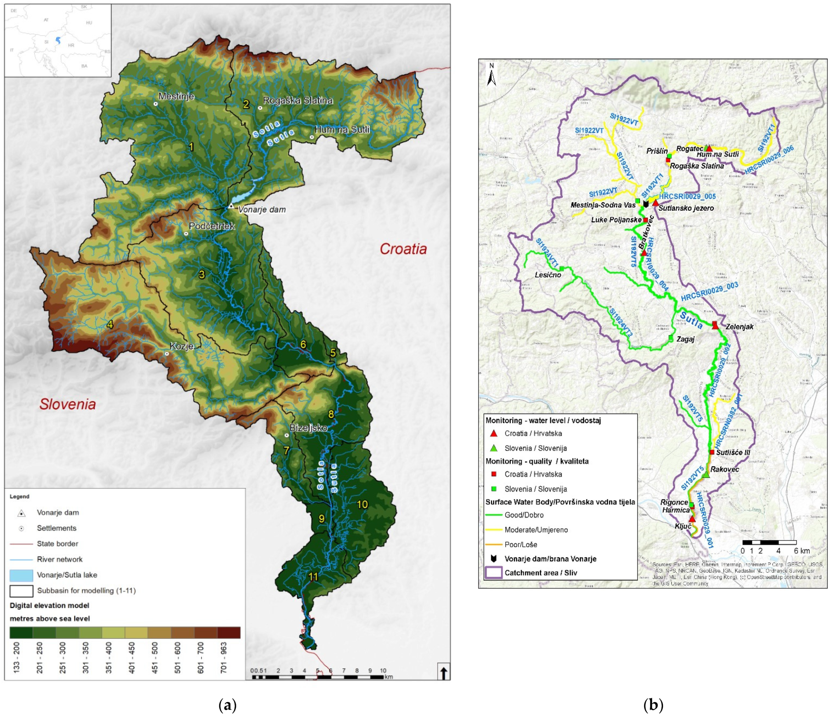
The Sutla River forms the border between the Republic of Slovenia and the Republic of Croatia. The size of the Sutla river basin is 590.6 km
2. After the construction of the Vonarje dam in the 1980s, the Sutla Lake/reservoir Vonarje, was constructed in natural retention with a volume of 12.4 million m
3 and filled in 1980. (
Figure 1).
The aim of building the reservoir was to provide water for the public water supply system for Croatian and Slovenian settlements, irrigation, and flood protection. Shortly after filling, the reservoir eutrophicated due to nutrient intake and organic pollution from point and diffuse sources, so it was emptied in 1989 and now functions as a dry retention basin for flood protection [
5]. Research has been conducted on the Sutla River Basin to address the effective quality management of transboundary rural river basins [
6].
Figure 1a presents a digital elevation model, hydrographic network with lakes and settlements of the rural transboundary Sutla River Basin and the location of Vonarje dam. The Sutla River Basin is divided into 11 sub-basins.
Figure 1b presents the transboundary Sutla river basin, the location of Vonarje dam, water status of the surface water bodies, and locations of surveillance and operational monitoring stations. Surveillance monitoring of the Sutla River Basin surface water bodies has been carried out for parameters: biological quality elements, hydromorphological quality elements, physico-chemical quality elements, priority list pollutants, and other pollutants [
1]. The selection of monitoring stations for surveillance monitoring of the surface water bodies have been done related to the same criteria for Croatia and Slovenia, but each country has its own surveillance monitoring system, and each country has different water bodies of the Sutla river. Most of the measuring stations are on the main course of the Sutla river because, in the past, the biggest problems occurred on it. All water bodies, upstream of the Vonarje dam, have moderate water quality status and all water bodies downstream of the Vonarje dam have good water status. Data obtained from the Sutla River Basin indicate a load of organic matter, nutrients, and sediment in the Sutla River water bodies (
Figure 1b), despite implemented water quality measures, especially the construction of wastewater treatment plants in Rogaška Slatina and Hum na Sutli and implementation of the EU Common Agriculture Policy measures.
For centuries, the Sutla River was the border river between the Austrian and Hungarian parts of the Habsburg Empire, but this was not a major obstacle for residents on both sides of the river [
5]. In 1899, the Sutla river caused damage during annual floods, and the most important hydrotechnical regulation of the river Sutla has been done. The river Sutla has a mostly natural hydraulic and hydrological regime although with the construction of the Vonarje dam and the reconstruction in 2020 [
5], the natural hydrological regime was disturbed by changes in the transport and a significant reduction of suspended sediment. Since Sutla River is a border watercourse of the Republic of Croatia and the Republic of Slovenia, each country has defined its own water monitoring program (quantity, quality, sediment), measuring stations and water bodies (
Table 1).
After Rogaška Slatina measure station, water body CRSI0029 005—retention Vonarje/Sutla Lake, is without measure station. The Republic of Croatia has declared six water bodies on the Sutla River and one water body on the tributary Sutlišće. The Republic of Slovenia has declared two water bodies on the Sutla River and three water bodies on the tributaries Mestinjščica and Bistrica. Within the Croatian and Slovenian monitoring, there is no hydromorphological measuring station on the river Sutla. The assessment of the general hydromorphological condition was based on available data for several hydromorphological elements related to water quality according to the European standard EN15843, as well as on the prescribed Methodology of monitoring and evaluation of hydromorphological indicators [
6,
7]. The sediment assessment methodology is prepared according to the WFD, based on the DPSIR (Driving Forces- Pressure–State–Impact–Measures) problem-oriented approach with the analysis of all relevant data and information. Driving Forces are settlements and agriculture, and the significant pressures are the diversion of watercourses and changing of the flow regimes: the impact of artificial structures in the riverbed, the impact of changes in the wider catchment area on the character of the natural flow. Longitudinal cross-section includes the feature of the longitudinal flow of an individual watercourse. Environmental objectives can be achieved only if appropriate flow and sediment regimes and related river morphology quality are guaranteed. For the Republic of Slovenia, there are no available data on sediment assessment. Downstream of the Vonarje dam, the yield of new material is reduced, and water with its erosion activity deepens the riverbed by increasing the speed of the flow in the upper course. Together with the changed hydrological regime indicates the risk of eutrophication of the Sutla River, as well as the risk of not achieving good water status and environmental objectives of the Sutla River Basin. A significant amount of sediment stops at the Prišlin dam, which was built to reduce sediment input to Sutlansko Lake/Vonarje Reservoir and reduce its operational volume. Due to significant hydro-morphological changes, the flow has changed and, also, the water status. The obligation to define environmental flow (E-flow) in the European Union Water Framework Directive (WFD) [
8] is not explicit, and the implementation of the WFD is more focused on water quality. Related to the presented facts, an innovative holistic approach to an environmental flow (E-flow) assessment downstream of dam Vonarje has been prepared [
9]. The Pressures result in disruption of the natural water regime and its changes; changes in the transport of suspended and bed sediment, i.e., a significant reduction in transport in relation to the period before the construction of the dam; disturbing the status of basic physico-chemical indicators and the status of biological indicators of water quality and hydromorphological elements that describe the ecological state of surface waters. The change in the State water indicators is reflected in the changed hydrological characteristics of watercourses downstream from the dam, as well as the quantity and quality of sediments necessary for the preservation of ichthyofauna. It is necessary to analyze all available State indicators relevant for the good water status (physicochemical, biological, hydromorphological indicators, and sediment) and surveillance monitoring data. Also, the significant Pressures are nutrients and sediment that caused eutrophication of the Sutla Lake in the past. For the spatial quantification of the nutrients and sediment in the Sutla River Basin, the Soil Water Assessment Tool Model (SWAT) has been used on the base of the land use map, assessment of the pressures (settlements, agriculture, industry), conducted measures related to the wastewater treatment plants and good agriculture practice according to the EU Common Agriculture Practice, supported with ArcGIS tool. Based on results, some agriculture and hydromorphological measures, from the EU Nature Water Retention Measures Catalogue and SWAT Catalogue, relevant for the minimization of the sediment transport, have been proposed. The conservation of aquatic ecosystems and ecosystem services for human well-being is significantly influenced by river morphology, which includes the processes of sediment transport and deposition. Changes in the balance of sediment transport cause deepening of the riverbed and collapse of banks, creating slowdowns due to clogging of the flow profile and increasing flow velocities in the watercourse under the action of which local erosions occur. The consequences of changes in the regime of sediment transport in the river flow are usually not immediately visible.
3. Results and Discussion
According to the presented sediment management methodology, the research about sediment management in the Sutla River Basin has been done. Based on the terrestrial, spatial, and land use analysis with the support of ArcGIS, it is concluded that the significant Driving Forces are settlements and agriculture. The changes related to the longitudinal continuity on the Sutla River are caused by the construction of the dam Vonarje and barrier Prišlin. The overall hydromorphological assessment for the section at the measuring station of Luke Poljanske located downstream of the Vonarje dam, and its water body, reflects a slightly changed status. The hydrological state is slightly altered, and the longitudinal cross-section is continuous. The banks of the watercourse are natural, with slightly altered coastal vegetation. Erosion sedimentation processes reflect a moderate deviation from the natural state. The lateral connection of the river with the floodplain and the possibility of lateral movement of the riverbed are mostly natural [
10,
11]. The Sutla River, as part of the Natura 2000 ecological network, is important for the conservation of 8 fish species [
12]. Watercourses, or parts of them, with a bottom drop between 1.5 and 3.2‰ are characteristically inhabited by barbel with accompanying fish species [
13] or Barbus balcanicus for the part downstream of the Vonarje dam. Due to untreated wastewater and leaching of large amounts of nutrients from agricultural and forest lands [
6], the degree of trophy is rising. River sediment transport is a vital component of the natural hydromorphological regime of every open watercourse, including the Sutla River. However, due to anthropogenic influences and anthropogenic impacts on the Sutla River and its banks, the natural processes in sediment transport have changed significantly downstream of the dam Vonarje. Changes in the longitudinal continuity of the river Sutla, caused by the construction of the dam and hydro-technical structures in the watercourse bed, are defined as the types of pressures. The influence of the basin structure is mostly related to the retention of sediments upstream, which directly affects the morphology of cross-sections of watercourses downstream. The significant pressures of the transboundary rural Sutla River basin can cause changes in the hydrological regime and biological indicators of water quality. When designing the construction of the Vonarje dam and Sulansko Lake/Vonarje reservoir, according to the regulations at the time, the biological minimum flow downstream of the dam was defined. Downstream of the Vonarje dam, based on the Sutla river basin research, the E-flow was defined by linking hydrological, morphological, and ecological characteristics with the holistic approach [
10]. In addition to hydrological methods, biological indicators (fish) were introduced, and a new significantly higher E-flow downstream of the dam was obtained [
9]. According to the Decree on the water quality standard (OG 66/2019) [
14], in year 2016, on water quality stations in Croatia the hydromorphological monitoring and sediment assessment started (
Table 2).
Retention Vonarje/Sutla Lake Vonarje is water body CRSI0029 005, without measure station and without assessment. Biological monitoring with sediment assessment, according to the planed monitoring program, is performed every 5 years, and started also in 2016. The measuring station Prišlin for the surveillance monitoring, located just before the sediment retention barrier, is the monitoring station for water and sediment quality on the river Sutla. Considering the location of Prišlin in relation to the topography of the river basin, and the role of the barrier to reduce sediment input into the Vonarje/Sutlansko reservoir, the measured data show moderate to poor water status and sediment quality indicating anthropogenic impact. It should be noted that data from the surveillance monitoring program are needed to assess the status of water and achieve environmental objectives but given the location of measuring stations and the period of their operation, it is difficult to interpret them. This was confirmed by the assessment of nutrient and sediment transport in the basin resulting from land use, and point and diffuse sources of pollution, using the mathematical model SWAT [
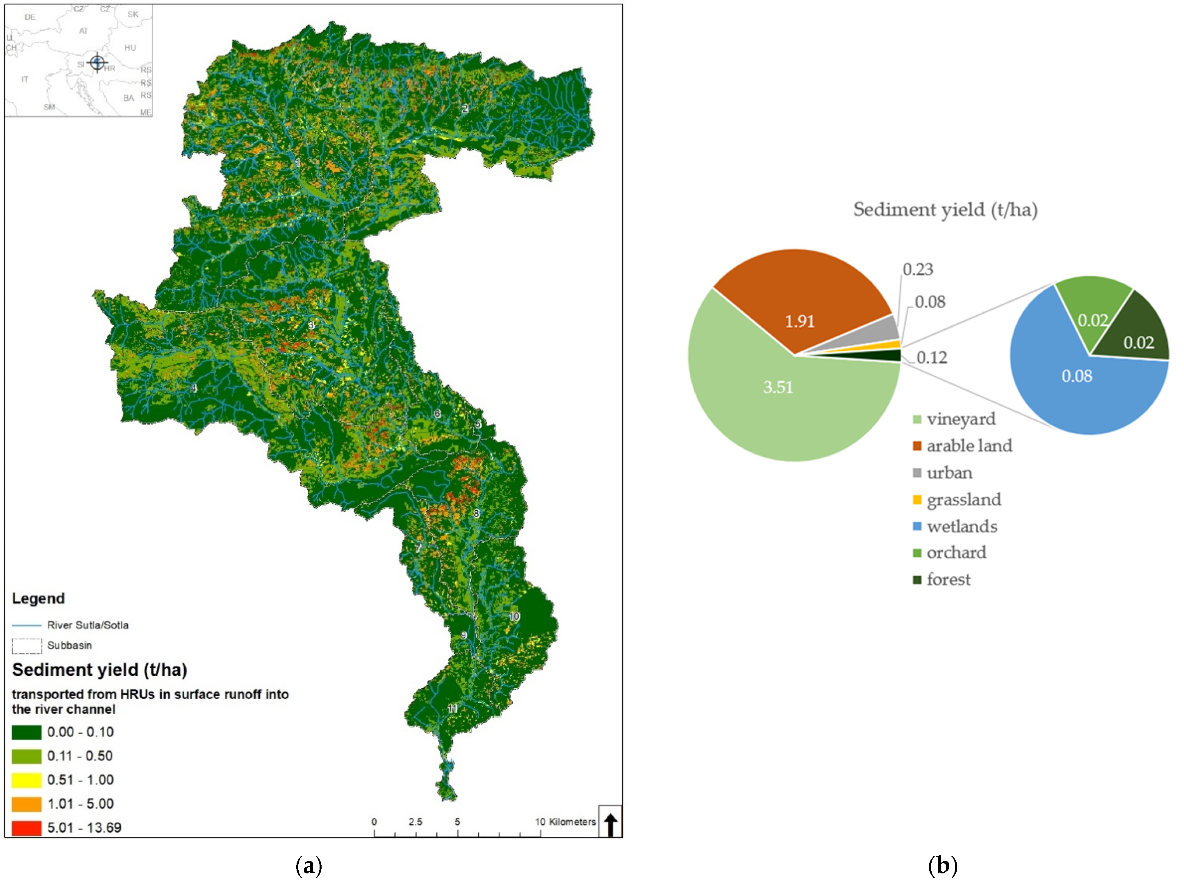
15]. If there was a significant amount of sediment, soil loss, and erosion, it was necessary through agricultural education to influence agricultural land to be overgrown (never bare). In critical cases, afforestation should be implemented to prevent erosion and sediment removal. In the spatial presentation the red color presents the areas of the critical level of the calculated sediment, nitrate-nitrogen, and phosphorus in the Sutla river basin (
Figure 2a).
The sediment source in this river catchment is spatially heterogeneous and, on average, 0.78 t/ha/year. The hydrologic response unit (HRU) is the smallest spatial unit of the model. This study shows that in certain HRUs, sediment yield can reach up to 31.61 t/ha/year [
15]. This value can be exceeded during periods of heavy rainfall. The highest amount of sediment was transported from vineyards (3.51 t/ha/year), followed by arable lands (1.91 t/ha/year) [
15] (
Figure 2b). “Tailor made” agriculture measures, especially for the sub-basins 1 and 2, are proposed: terracing operation with the effect of removing suspended solids (SS 85%), filter strips (SS 65%), residue management (SS 71%), generic conversation practice (SS 75%), wetlands (SS 77%), contouring and strip cropping. The Environmental Quality Standards Directive 2008/105/EC, together with the WFD, defines the good chemical status of water bodies and the obligation to achieve it, and provides a legal basis for the control of priority substances in sediment and biota [
3]. The Decree on water quality standards (OG 96/19) [
14] is limited to water column concentrations and should be also for sediment and biota in the improved surveillance monitoring, as well as a cost-effective approach to initial pollution review, comparing pollution concentrations in different areas, and identifying possible sources of pollution [
16].
4. Conclusions
On the example of the Sutla river basin, based on presented results, it can be concluded that sediment management must be an integral part of integrated water management, which requires specific knowledge and an interdisciplinary approach to the river basin and sediment dynamics. The results of this study show that decisions on introducing measures for preserving water quantity and quality, based on BASE MODEL, must be upgraded related to climate change impact scenarios, and discussed in depth among decisions- and policymakers before the implementation of additional “tailor-made” river basin measures for reducing hot spots of nutrients and sediment in the Sutla River Basin with SWAT model support. Establishing and maintaining a flow regime and defining the E-flow is an important element in the conservation of river ecosystems and the services they provide and should be included as a constraint in water resources assessment and national legislative frameworks [
9,
17].
To successfully manage water quality within integrated river basin management, it is necessary to conduct impact assessments and model different scenarios of the impacts on waters to implement appropriate additional “tailor-made” river basin measures, as well as appropriate monitoring that includes appropriate monitoring of sediment regime and appropriate hydromorphological monitoring. In the analysis of the risk of not achieving good water status and objectives of environmental protection of the river basin, it is important to include the hydrological regime and sediment regime more intensively, hydromorphology, and the realization of ecosystem services within the integrated water management [
17].
Sediment samples should be collected at a frequency corresponding to the expected sediment changes. This indicates the need to improve the surveillance monitoring of the Sutla River by including sediment and biota, which are less affected by rapid changes in water quality and subject to random or systematic/seasonal changes [
1]. It should be emphasized that healthy ecosystems, which are able to provide ecosystem services, should have, in addition to the appropriate water quality for the appropriate type of watercourse, adequate sediment transport and morphodynamics. The concept of integrated river basin management includes a holistic approach that includes application in all aspects of the assessment of water and sediment regime. The management of the rural transboundary river basins, such as the Sutla River Basin, is a particular challenge, even in cases where both countries (Croatia and Slovenia) are members of the EU and implement WFD requirements.


