Next Article in Journal
Significance of Hydromorphological and Sediment Analysis in River Basin Water Quality Management
Previous Article in Journal
Impact of a Wind Farm on the Avifauna of a Mediterranean Mountainous Environment
 
 
Please note that, as of 4 December 2024, Environmental Sciences Proceedings has been renamed to Environmental and Earth Sciences Proceedings and is now published here.
Proceeding Paper

Wellhead Protection Areas Vulnerability and the Use of Pesticides: The Treviso Province Case Study †

Department of Civil, Environmental and Architectural Engineering, University of Padova, Via Francesco Marzolo 9, 35131 Padova, Italy
*
Author to whom correspondence should be addressed.
Presented at the International Conference EWaS5, Naples, Italy, 12–15 July 2022.
Environ. Sci. Proc. 2022, 21(1), 13; https://doi.org/10.3390/environsciproc2022021013
Published: 19 October 2022

Abstract

:
Recent studies have experimentally analyzed the leaching at local scale of some of the most diffused pesticides used in agriculture. To evaluate the vulnerability of wells supplying drinking water to PPPs used within wellhead protection areas (WHPAs), a map of vulnerability has been developed starting from the PPPs sales data in the Treviso province. The PPPs spatial distribution, obtained from the sellers’ locations and the extension of the cultivation areas was superimposed with the extension of the WHPAs, led to a vulnerability map, giving a clear picture of the wells that require PPPs-specific actions.

1. Introduction

According to the European and Italian regulations, wellhead protection areas (WHPAs) are established around drinking water intakes from wells to prevent, by exclusion of any pointwise or diffuse source of pollution from the well location, the extraction, and the distribution of contaminated groundwater to the population. In WHPAs many activities are forbidden but not the use of plant protection products (PPPs), which should be carried out following procedures specifically developed to limit the contamination risk for the water resource. However, recent experimental evidence achieved in Treviso province, Italy, Ref. [1] has shown the potential leaching of PPPs residues from the ground surface via preferential flow paths. Agricultural practices are sometime developed using chemical PPPs in areas where groundwater is extracted for drinking water supply. Both activities represent vital elements in each of our lives, but the interactions that might occur between subsurface water and agricultural practices [2] jeopardize the use of groundwater as a drinking water resource. Concerns on the vulnerability of groundwater to pesticides has raised among people managing supply wells, underpinned by the recent environmental monitoring activities that revealed a diffuse pesticides presence in all the inland fresh-water bodies ([3,4]). Moreover, the development of PPPs-specific actions to minimize the contamination risks for groundwater results in most cases is difficult given the different behavior of each chemical species and the wide spectrum of 400 PPP active ingredients that are allowed for use in the European agricultural lands. Geographical information system (GIS) developed considering spatial information related to pedological soil properties, land uses, and types of cultivation as well as the active ingredients interacting with the groundwater in a given agricultural area, can be a valuable tool to identify wells at risk of contamination. Many examples of these analyses based on GIS are reported in the literature. These concern risks for surface water contamination by pesticides or other pollutants from pastoral agricultural activities, as in the cases of Quaglia et al. [5] in a 10.7 km2 area in Belgium and Foster and McDonald [6] in the British uplands. The former including also spatial information on potential soil erosion, considered as the main cause of pesticides reaching surface water bodies in that study area. Data on pesticides application rates per type of cultivation and spatial distribution of crops were used to develop pesticide use maps in the works of Dabrowski [7], for a 105 km2 basin in South Africa, and Habran et al. [8], for the Wallonia region (20 thousand km2) in Belgium. Both studies were aimed at identifying where specific pesticides were applied. This was to prioritize environmental monitoring activities or public health screening programs. However, the amount of the pesticides’ application was not considered. Larsen et al. [9] and VoPham et al. [10] focused their attention on the pesticides exposure of people living near agricultural areas. The former used public data on pesticides application rates to estimate the potential exposure of the Canadian population. The latter via Landsat images, accounted for the seasonal variation of a 20,000 km2 agricultural area in California, to investigate, classified by subareas, the individual exposure history to pesticides residues displaced from the agricultural fields by the wind-drift phenomenon. Most of published research dealt with surface water contamination, and a limited number of GIS-based analyses have been developed concerning the vulnerability of groundwater to pesticides. In a 30,000 km2 region of Thailand, Thapinta and Hudak [11] developed a map by analyzing pesticides in wells together with geospatial information related to land use, pedological soil properties, and hydrological forcing measurements. In a smaller area (Woodruff county, Arkansans (USA), ~1000 km2), Akbar et al. [12] achieved good results in evaluating the leaching potential of the pesticide bentazon, predicting its presence in the wells in agreement with the field observations. The authors underline, in light of the results obtained, the utility of the vulnerability maps as a tool to better allocate monitoring resources. In the present work we developed a vulnerability map for the WHPAs located in the Treviso province, Italy. With respect to previous works, we consider the extension of the WHPAs to provide a preliminary assessment of which wells are at risk of pesticides contamination. Starting from the georeferenced information on PPPs sales and land use in the study area, we focused our attention on the wine-growing areas of the Prosecco production and on the PPPs used in the Glera-vine integrated defense, being the top selling products in the province. However, owing to the obtained georeferenced database of PPPs sales, the map can be easily adjusted to other types of cultivation.

2. Materials and Methods

2.1. The Study Area

In the north-eastern Italy, the diffused agricultural activities interact with the WHPAs located in the territory. This manifests in the piedmont area of the Treviso province (Veneto, Italy), where the land cover for vineyards for the Prosecco production is increasing. This has mainly happened in a hilly area of 8400 hectares, named hills of Prosecco (Figure 1), classified through the label of denomination of controlled and guaranteed origin (DOCG–European Regulation CE n. 479/2008) and recently recognized as a UNESCO heritage. To keep up with the intense productivity, the wine-growing activity requires phyto-regulation (e.g., application of fertilizers) and defense strategies from diseases caused by fungi, bacteria, and viruses. Policies of the DOCG is to limit the use of PPPs, but in particular cases the vine defense can be achieved only using chemical-based PPPs, as confirmed by the PPPs sales data collected in the province. More than 10 million units (liters or kilograms depending on the PPP formulation) have been sold in 2019 in the province of Treviso and among these, 910 thousand units (approximately 10%) were used in the DOCG territories. Uncertainties about the environmental fate of the PPPs residues in the soil after the applications and about the harmfulness of PPPs mixtures (e.g., fungicides, pesticides, and fertilizers are commonly used together in a single vine treatment), have raised concerns about possible alterations of the groundwater quality and risks for the human health. This fact is of absolute relevance considering that in the Treviso province a volume of 101.5 million cubic meters of water is extracted every year from wells to supply drinking water to a population of approximately 900,000 inhabitants [13] and that around 60% of this volume is supplied from the Prosecco area.

2.2. Data Collection

Table 1 reports the sources of the data used for the WHPAs vulnerability assessment in the Treviso province. The pesticides sale data in the time period 2012–2019 in the 94 municipalities of the Treviso province have been collected by courtesy of the Regional Environmental Agency, ARPAV. Information on the agronomic practices carried out in the Prosecco production has been retrieved from the technical guides commonly consulted by the insiders, the Winemaking Protocol (Protocollo Vitivinicolo in Italian language, www.prosecco.it). The protocol is drawn up every year and reports the updated defense practices that must be used against the common diseases acknowledged in viticulture, e.g., botrytis, iodine, esca, downy mildew. The protocol indicates the PPPs active ingredients that can be used to eradicate the vine diseases. The principal insecticides and generic herbicides to control pests and weeds are indicated too. The information about the harmfulness of all the vine-specific PPPs was retrieved from the safety sheet provided with each product, available in the technical consultation site Fitogest (fitogest.imagelinenetwork.com).

2.3. GIS-Based Analysis

The vulnerability map of WHPAs to vine-specific PPPs was developed in three phases connected to each other. 1. Identification of the PPPs involved in the vine cultivation through the information reported in the Wine-making Protocol 2019 and creation of a database containing all the vine-specific PPPs. 2. Hazard classification of the vine-specific PPPs based on the CLP pictograms and statements (Classification, Labelling and Packaging regulation EC 2008/1272 summarized in Table A1 contained in the safety sheets. 3. Collection on a GIS model of the following information: (i) vineyards extension retrieved from the land-use geospatial data (CLC18), (ii) extension of the WHPAs, and (iii) spatial distribution of the vine-specific PPPs. We stress that the latter was obtained by assuming that the vine-specific PPPs were used in the same municipality of sale or in the neighboring ones. The hazard classification was reorganized starting the CLP of Table A1 by assigning to each product a hazard class ranging from 1 to 5, where 1 stands for low hazard and 5 for very high hazard. Hazard class 5 was assigned to the products showing both the GHS ids GHS06 and GHS08 in their safety sheets while hazard class 1 was assigned to the ones with no CLP pictograms or hazard statements. To identify the WHPAs extension, among the wells supplying water for human consumption, only wells exploiting phreatic aquifers were considered. This has been done to account, in this first approach to the problem, to PPPs infiltration occurring at a distance from the wells shorter than the characteristic length of the WHPAs (L ≈ 102 m). This approach can be justified assuming that the residence time of capture areas in deeper aquifers is much larger than the one characterizing WHPAs related to superficial wells. WHPAs on the territory were defined, for the sake of simplicity, by means of the geometric criteria, i.e., as circular areas having radius of 200 m around the wells. The use of the more realistic hydro-geological criteria (Resolution of the regional council of the Veneto region, 1621/2019), being the necessary data available, leads to different planimetric definition of the WHPA, whose shape greatly differs from the circular one. As a consequence, WHPAs may exceed the 200 m radius more times, and to consider this fact, computations are developed using also a 2000 m radius as upper limit.

3. Results and Discussion

3.1. PPPs Distribution Analysis

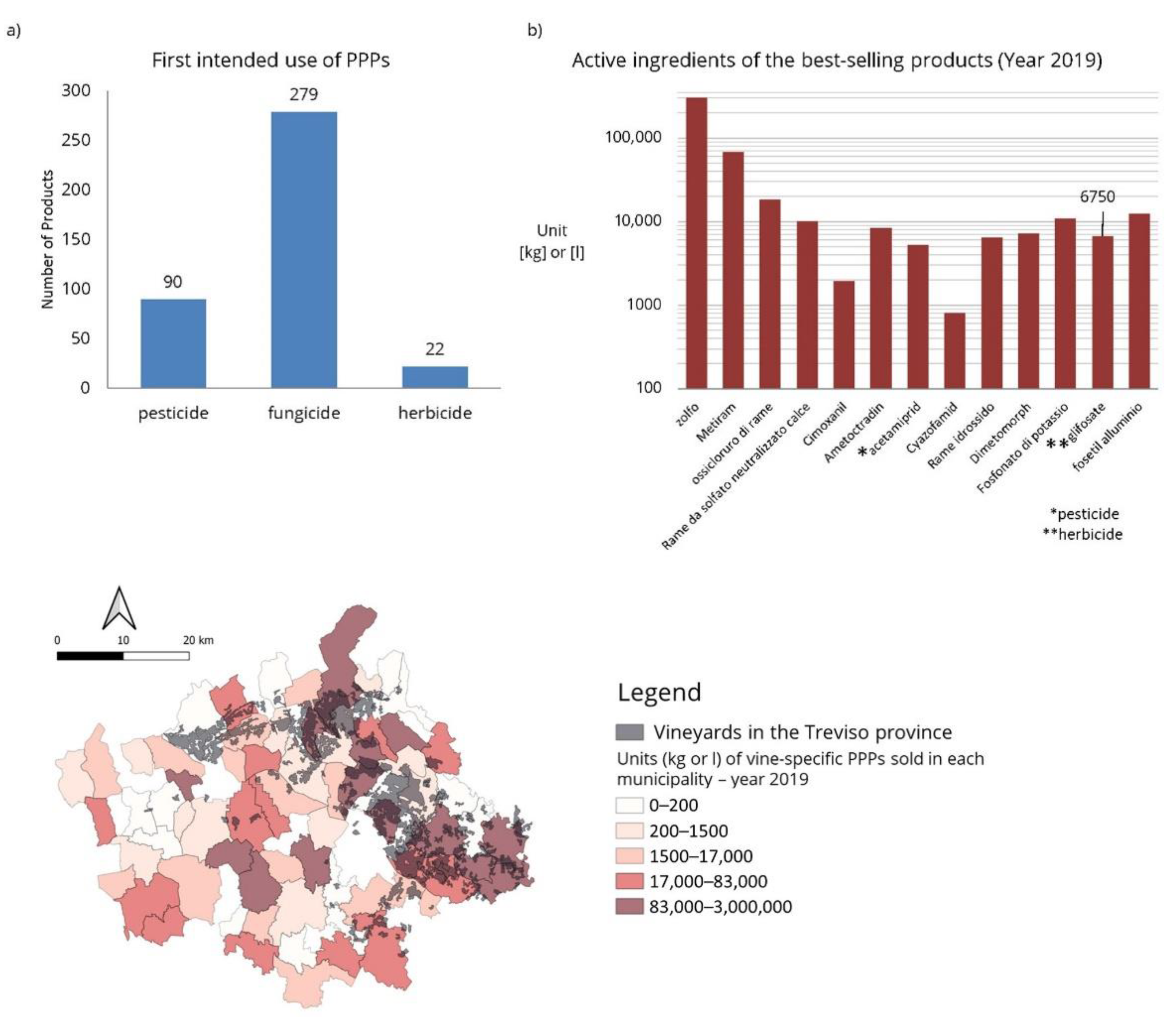
Figure 2 reports the results achieved by analyzing the PPPs sale data of 2019. In the map of the study area, each municipal territory was colored according to the units of PPPs sold, showing a larger number of the registered sales in the northeastern municipalities. The extension of the wine-growing territories in the map (from CLC2018, grey color), hints that the PPPs sales in the Treviso province were principally related to the wine-making practices. This hypothesis is confirmed by the information retrieved by the analysis of the sold active ingredients that is reported in the bar-plots Figure 2a,b. The first shows that the majority of the PPPs active ingredients sold (almost 280) were fungicides. The latter, reporting in a log-scale the units of the active ingredients contained in the first 13 best-selling products, in this order: sulfur, metiram, neutralized copper sulphate lime–Bordeaux Mixture, cimoxanil, ametocradin, acetamipirid, cyazofamid, copper hydroxide, copper oxychloride, dimetomorph, potassium phosphonate, glyphosate, phosethyl aluminum, shows that the majority are fungicides, with the exceptions of glyphosate, which is a herbicide, and acetamipirid, which is an insecticide. The first eight sales all refer to active ingredients applied on leaf or plant, a treatment commonly developed in vineyards. The only one used for weeding, and therefore applied directly on the ground, is glyphosate. The PPPs use, even if related to the only 2019, confirm the hypothesis that the main diseases affecting the vineyard are fungal or bacterial.

3.2. Vulnerability of WHPAs

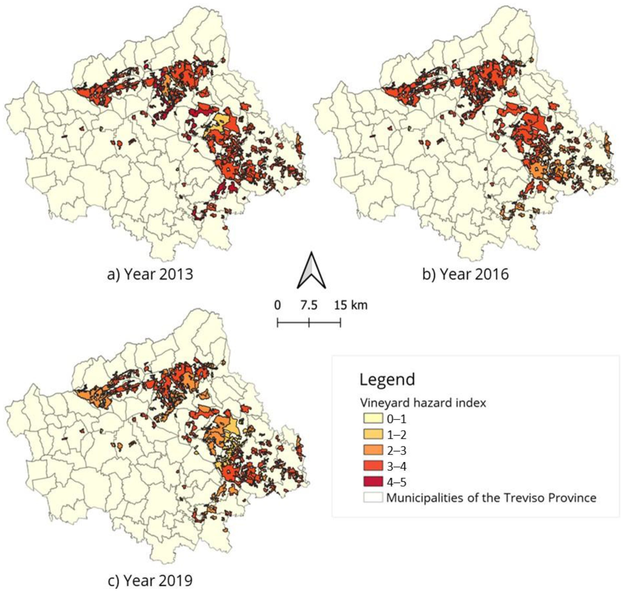
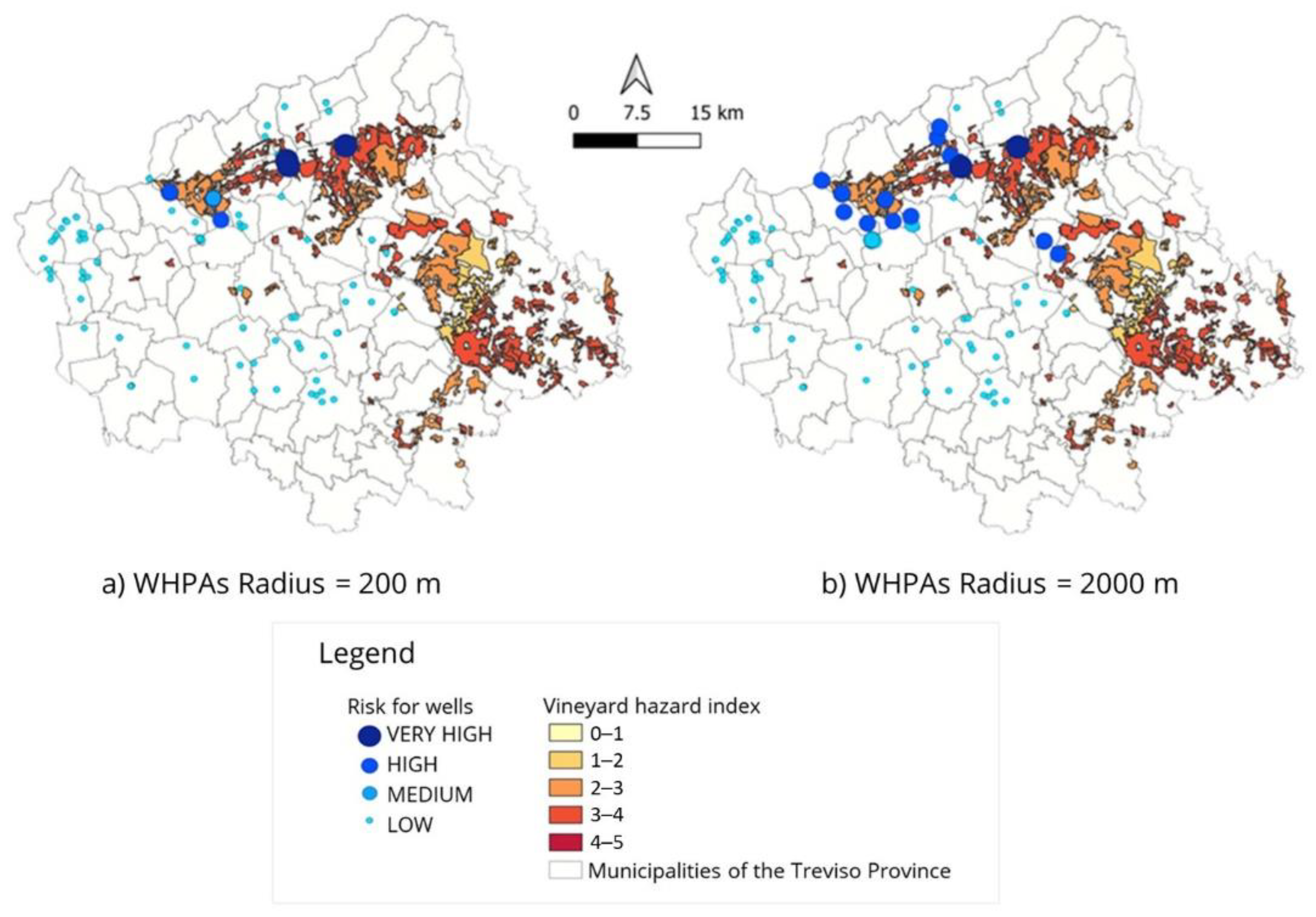
To understand if any changes occurred along the investigate time period 2012–2019, the harmfulness of the vine-specific PPPs distributed in the years 2013, 2016, and 2019, together with the extension wine-growing areas (CLC2018), were used to realize the hazard maps reported in Figure 3. The hazard level is indicated with colors ranging from yellow, for null or low hazard areas, to dark red, for very-high hazard areas. In 2016 the majority of wine-growing areas were characterized by a high hazard level while in 2019 areas with medium and high hazard levels were equally distributed. In 2013 the overall hazard level of the vineyards was in the middle of the other two. However, since the complete national regulation on the PPPs sales registration was available to the regions in 2014 only, missing PPPs sales data in years 2012 and 2013 limit the reliability of the hazard map developed for this latter. Considering the sales data collected along the entire period 2012–2019, although the quantity of PPPs sold in the province is increasing, the total hazard, on average, is decreasing. This result can be linked to the gradual changeover of many winemakers to the more profitable and advertised biological market. From 2013 to 2016, the biological cultivated hectares increased from 11,741 to 18,549 hectares in the Veneto region (http://dati.istat.it/index.aspx?queryid=31926, accessed on 18 October 2022). The information obtained from the 2019 hazard map was used to develop the vulnerability maps reported in Figure 4. The map (a) shows that, already by considering inadequate WHPAs [14], defined as circular areas around the wells having a 200 m radius, four wells have a very high vulnerability, six wells have a high vulnerability, one well has a medium vulnerability, and all of them are located in the DOCG area. This result supports quite well the problem statement presented at the beginning of this work, being the area for the Prosecco production an example of highly exploited agricultural territory that is also strategic for the extraction of drinking water for human consumption. The remaining wells distributed within the Treviso province present a low vulnerability. The choice among very high, high, medium, and low vulnerability, depends on the WHPA surface interested by PPPs and on the level of hazard related to them. As previously explained, due to difficulties to obtain WPHAs’ extensions by isochrone criterion, a second vulnerability map was developed assuming a geometric criterion but increasing the radius up to 2 km. In other words, we realized a trick to account for both elongated shapes of the WHPAs—related to specific subsurface hydrogeological conditions—and spreading phenomena (e.g., wind drift) that affect the application of the plants’ treatments. In this scenario, 23 wells classified as low vulnerability, present now a medium or high vulnerability (Figure 4b). This means that, by properly defining the WHPAs—approximately in between the two considered scenarios—the vulnerability map can provide a prioritization of the wells and of the PPPs-specific actions required to minimize the risk for drinking water supplied for human consumption.

4. Conclusions

The geospatial analysis of the plant protection products sale data in the province of Treviso showed that PPPs sales are increasing and that, within the considered area, the sold PPPs are mainly destined to wine-growing practices. This is confirmed by the fact that the best-selling products are composed of fungicide active substances, being fungal and bacterial adversities mainly affecting the vine plant. Under the assumption that PPPs are used in the municipality of sale, the CLP-based hazard analysis developed for the vine-specific PPPs, led to the outlining of a map showing the hazard of the wine-growing areas. The superimposition obtained between the wellhead protection and the wine-growing areas integrated in GIS, led to a vulnerability map for wells supplying drinking water. The final result depends on the PPPs hazard and the WHPAs extension, the latter being the uncertain definition without the knowledge of the hydrological and geological features of the subsurface at proper scale. Therefore, in a scenario developed assuming the WHPAs as defined by the 200 m radius geometrical criterion, according to D. Lgs 152/2006, a very high vulnerability was ascribed to 4 wells, a high vulnerability to 6 wells, a medium vulnerability to 1 well, being all of them located in the Prosecco area. To account for the uncertainties in the definition of the WHPAs extension, a rough increase of the radius, suggested by the regulation, was applied by changing the 200 m into 2000 m. By this way, we also account in some way for the spreading phenomena, like wind drift, that moves the PPPs beyond the borders of the cultivated areas. In this scenario, 23 wells that before were classified with a low vulnerability, present now a medium or high vulnerability. The obtained result allows to identify agricultural areas where limitations in the PPPs use should be applied. Obviously, a further step of the procedure, not considered here, must be developed to overcome limitations of the present work related to (i) the true amount of PPPs applied by each farmer; (ii) the proper definition of the WHPAs extension; (iii) a realistic footprint of the aerial spread PPPs.

Author Contributions

Conceptualization, L.C. and P.S.; methodology, L.C.; software, L.C.; validation, L.C. and P.S.; resources, P.S.; data curation, L.C.; writing—original draft preparation, L.C.; writing—review and editing, L.C. and P.S.; visualization, L.C.; supervision, P.S. All authors have read and agreed to the published version of the manuscript.

Funding

This research received no external funding.

Data Availability Statement

Not applicable.

Acknowledgments

We acknowledge the companies Alto Trevigiano Servizi s.r.l. and Piave Servizi s.r.l for providing the data related to the location and the properties of the wells; Susanna Lessi of the Environmental Protection Agency of the Veneto region for providing the PPPs sale data; Maria Lucia Roggero for the development of the PPPs sales database for the Treviso province and development of the preliminary set-up of the GIS-based analysis. This research has been developed as a spin-off from the UNI-Impresa 2017 project SWAT by the “Dino Tonini” International centre of Hydrology.

Conflicts of Interest

The authors declare no conflict of interest.

Appendix A

Table A1. Information used for the development of the PPPs hazard classification.
PictogramGlobal IDHazard Statement and [Class] 1
Environsciproc 21 00013 i001GHS05Severe skin burns [1A, 1B, 1C]
Eye damage [1]
Environsciproc 21 00013 i002GHS06Fatal or Toxic (if swallowed, contact with skin, if inhaled) [1–3]
Environsciproc 21 00013 i003GHS07Toxic (if swallowed, in contact with skin, if inhaled) [4]
Skin irritation [2], Eye irritation [2]
Allergic skin reaction [1]
May cause respiratory irritation [ \ ]
Environsciproc 21 00013 i004GHS08May cause respiratory irritation [1] Eye irritation [2]
May cause genetic defects [1A, 1B, 1C]
May cause cancer [1A, 1B, 2], Causes damage to organs [1,2] May damage fertility or the unborn child [1A, 1B, 2]
May be fatal if swallowed and enters airways [1]
Environsciproc 21 00013 i005GHS09Toxic to aquatic life with long lasting effects
1 CLP regulation EC 2008/1272.

References

  1. Costa, L.; Mencaroni, M.; Dal Ferro, N.; Cardinali, A.; Camporese, M.; Morari, F.; Zanin, G.; Salandin, P. Water and pesticides infiltration in the vadose zone driven by natural forcings: Analysis of data from experimental sites. J. Hydrol. 2022; under submission. [Google Scholar]
  2. Arias-Estévez, M.; López-Periago, E.; Martínez-Carballo, E.; Simal-Gándara, J.; Mejuto, J.C.; García-Río, L. The mobility and degradation of pesticides in soils and the pollution of groundwater resources. Agric. Ecosyst. Environ. 2008, 123, 247–260. [Google Scholar] [CrossRef]
  3. Tang, F.H.; Lenzen, M.; McBratney, A.; Maggi, F. Risk of pesticide pollution at the global scale. Nat. Geosci. 2021, 14, 206–210. [Google Scholar] [CrossRef]
  4. ISPRA. National Report on Pesticides in Waters. Data 2017–2018 (Italian); Technical report; Istituto Superiore per la Protezione e la Ricerca Ambientale: Rome, Italy, 2020. [Google Scholar]
  5. Quaglia, G.; Joris, I.; Broekx, S.; Desmet, N.; Koopmans, K.; Vandaele, K.; Seuntjens, P. A spatial approach to identify priority areas for pesticide pollution mitigation. J. Environ. Manag. 2019, 246, 583–593. [Google Scholar] [CrossRef] [PubMed]
  6. Foster, J.A.; McDonald, A.T. Assessing pollution risks to water supply intakes using geographical information systems (GIS). Environ. Model. Softw. 2000, 15, 225–234. [Google Scholar] [CrossRef]
  7. Dabrowski, J.M. Development of pesticide use maps for South Africa. S. Afr. J. Sci. 2015, 111, 1–7. [Google Scholar] [CrossRef] [Green Version]
  8. Habran, S.; Philippart, C.; Jacquemin, P.; Remy, S. Mapping agricultural use of pesticides to enable research and environmental health actions in Belgium. Environ. Pollut. 2022, 301, 119018. [Google Scholar] [CrossRef] [PubMed]
  9. Larsen, K.; Black, P.; Rydz, E.; Nicol, A.M.; Peters, C.E. Using geographic information systems to estimate potential pesticide exposure at the population level in Canada. Environ. Res. 2020, 191, 110100. [Google Scholar] [CrossRef] [PubMed]
  10. VoPham, T.; Wilson, J.P.; Ruddell, D.; Rashed, T.; Brooks, M.M.; Yuan, J.M.; Talbott, E.O.; Chang, C.C.H.; Weissfeld, J.L. Linking pesticides and human health: A geographic information system (GIS) and Landsat remote sensing method to estimate agricultural pesticide exposure. Appl. Geogr. 2015, 62, 171–181. [Google Scholar] [CrossRef] [PubMed] [Green Version]
  11. Thapinta, A.; Hudak, P.F. Use of geographic information systems for assessing groundwater pollution potential by pesticides in Central Thailand. Environ. Int. 2003, 29, 87–93. [Google Scholar] [CrossRef] [Green Version]
  12. Akbar, T.A.; Lin, H.; DeGroote, J. Development and evaluation of GIS-based ArcPRZM-3 system for spatial modeling of groundwater vulnerability to pesticide contamination. Comput. Geosci. 2011, 37, 822–830. [Google Scholar] [CrossRef]
  13. Trentin, T. Setup of Sensor Network and Modelling of the Aquifer System in the High Venetian Plain between Treviso, Padova and Venezia. Ph.D. Thesis, Department of Civil, Environmental and Architectural Engineering, University of Padova, Padua, Italy, 2021. [Google Scholar]
  14. Stauffer, F.; Guadagnini, A.; Butler, A.; Franssen, H.J.H.; Wiel, N.V.D.; Bakr, M.; Riva, M.; Guadagnini, L. Delineation of Source Protection Zones Using Statistical Methods. Water Resour. Res. 2005, 19, 163–185. [Google Scholar] [CrossRef]
Figure 1. Map of the Treviso province showing the locations of the pumping wells and the areas interested by vineyards.
Environsciproc 21 00013 g001
Figure 2. Analysis of the active ingredients class of use (bar-graphs (a,b)) and map reporting the spatial distribution of the PPPs sales.
Environsciproc 21 00013 g002
Figure 3. Hazard maps developed for the wine-growing areas of the Treviso province.
Environsciproc 21 00013 g003
Figure 4. Vulnerability map for the wells of the Treviso province.
Environsciproc 21 00013 g004
Table 1. Data about PPPs, wells, and land use in the Treviso province accompanied with sources.
DataSource
PPPs sale dataPrevention, Food Safety, Veterinary Department, Veneto Region (ARPAV elaboration)
PPPs use in vineyard2019 Winemaking Protocol, Consortium for the Prosecco DOCG protection
PPPs safety data sheetsFitogest technical consultation site
wells properties and locationAlto Trevigiano Servizi and Piave Servizi
Cartographic dataVeneto RegionSuperior Institute for Protection and Environmental Research (ISPRA)
land useCorine Land Cover 2018 (CLC18)
Publisher’s Note: MDPI stays neutral with regard to jurisdictional claims in published maps and institutional affiliations.