1. Pompeii, between Knowledge and Conservation
With an extension of 66 hectares, of which 45 are excavated and 33 are open to the public, Pompeii is the largest archaeological site in the world and one of the most visited. What makes Pompeii unique is not only the extent of the archaeological area which, due to universally known historical events, covers the space of an entire ancient city, but above all the quantity and quality of the archaeological evidence that the site has unearthed, which includes a wide range of movable artefacts, from everyday furnishings to the finest and most precious jewellery and especially fragments of walls, surface coatings, paving surfaces, which constitute what remains today of the ancient public or sacred buildings, roads and the necropolis, which, obviously not being able to be removed, remain in site, becoming the main attraction of the archaeological area and imposing extraordinary efforts in terms of restoration and maintenance, to conserve and preserve for future generations a unique and priceless heritage.
The risk of collapse and other similar losses due to accidental events or human neglect, which inevitably afflicts any archaeological site or context, becomes a particularly serious issue in Pompeii because of the extension of the site, the number of structures, the use of different techniques and materials, which are moreover exposed to atmospheric agents, sometimes without being able to count on adequate protective structures, and the constant stresses of thousands of tourists. These simple considerations make it necessary to consider the risk of losses in Pompeii as an unavoidable factor. Therefore, the only possible strategy becomes preventive maintenance, based on periodic recovery activities and not on sporadic emergency interventions.
The “Great Pompeii Project” (GPP), launched in 2012, is based on this awareness and on the experience gained at the national level with studies and the preventive maintenance projects on particularly complex sites [
1,
2], of which the “Linee guida per la conservazione delle architetture di interesse archeologico” [
3] is one of the major results. This project, funded by the European Union, gave the drafting of a “Knowledge Plan for Surveys and Diagnostics” a central role in the processes of protection, management and improvement of the site. In addition, considerable efforts were made not only to obtain an accurate overview of the state of conservation of the archaeological and monumental evidence, using an accurate survey and documentation of the degradation in progress, but also to create a dynamic and updatable information system capable of providing real and concrete support for a program of interventions which, from a logic of extraordinary actions and generally post-event, could be transformed into “planned conservation”.
2. Pompeii Sustainable Preservation Project. Purpose and Research Activities
The Pompeii Sustainable Preservation Project (PSPP) is an international project entirely based on fundraising and direct financing by private investors, which, operating within the extraordinary context of the necropolis of Porta Nocera in Pompeii, aims to research and experiment with methodologies, techniques and materials for the conservation and restoration of ancient monuments, combining research, heritage conservation and education [
4,
5].
Indeed, research activity is only one of the aims of the PSPP, as it is intended as a preliminary step to restoration and conservation works, conducted directly in the field by experts from different disciplines in collaboration with young restorers involved in the project through an annual summer school. The evaluation of the results achieved increases the initial knowledge base, which is made available for further conservation work in the future.
Building on the successful experience of the Herculaneum Conservation Project [
6,
7,
8], the PSPP operates through an international consortium of public and private institutions under the scientific coordination of the archaeological park of Pompeii, together with the Fraunhofer-Institut für Bauphysik (IBP), which conceived and directed the project and operate the Technische Universität München (TUM), the International Centre for the Study of the Preservation and Restoration of Cultural Property (ICCROM) and a group of researchers from the ex-Institute for Archaeological and Monumental Heritage of the National Research Council (IBAM-CNR), now part of the Institute of Sciences for Cultural Heritage (ISPC-CNR), Catania branch. In addition, these institutions support the PSPP with individual research projects: The School of Geography and Environment of the University of Oxford; the High Institute for Conservation and Restoration of the Italian Ministry of Culture (ISCR), the Department of Ancient History, Ludwig-Maximilians-Universität of Munich (Lmu München), the Deutsches Archäologisches Institut of Rome (Dai) and the University of Pisa.
The Pompeii Sustainable Preservation Project began in 2014 and carries out its activities within the extraordinary context of the necropolis of Porta Nocera and the adjacent Via Nucerina with annual programs that alternate between the three fundamental stages of research, restoration and learning (
Figure 1).
Thanks to the activities carried out until now, it has been possible to obtain an accurate overview of the state of conservation of the funerary monuments within the specific context of the investigation and to identify any causes of degradation in progress. This required an extensive campaign of surveys, necessary to obtain a reference base that would provide a reliable representation of the spatial location, dimensions and volume of each funerary building. Additional geophysical, chemical and microclimatic investigations allowed us to collect information about the environmental components of the context, useful for identifying the causes of possible structural deterioration. Finally, each funerary building was subjected to a process of analysis to define its technical and construction characteristics, the materials used and the main signs of deterioration.
The acquired knowledge made it possible to isolate multiple causes of degradation of abiogenic and environmental nature that affect the future conservation of the monuments. Among these, for instance, particularly serious were the effects on the foundation structures caused by the presence of groundwater, which was facilitated by the position of the two sectors of the necropolis of Porta Nocera and Via Nucerina, located in one of the lowest points of the entire archaeological area. In this way, it was possible to arrive at an overall view of the current level of conservation of the structures, while, at the same time, a process of monitoring the evolution of the main components of the environmental framework overtime was initiated. The response of the current protective structures (such as propping and metal covers over some tombs or glass protections applied on the walls of the most decorated tombs, where mural paintings or painted inscriptions were preserved) and the materials used in previous operations of restoration were also evaluated. The effects carried out on the environmental context by the thousands of visitors who visit the archaeological site every day were also an element of analysis.
The data collected made it possible to obtain a risk index for each funerary building in the investigated area and, from this, a list of priorities, which were considered in the restoration work carried out under the PSPP. The individual actions involved the application of innovative materials in limited parts of the monuments, the behaviour of which was subject to specific evaluations over time. The results achieved have made it possible to acquire valuable knowledge regarding the restoration work to be carried out, the materials that are most compatible with the environmental context, and, thanks to the results of an overall study of the components of the context, also the design of replacement protection structures compared to those currently present.
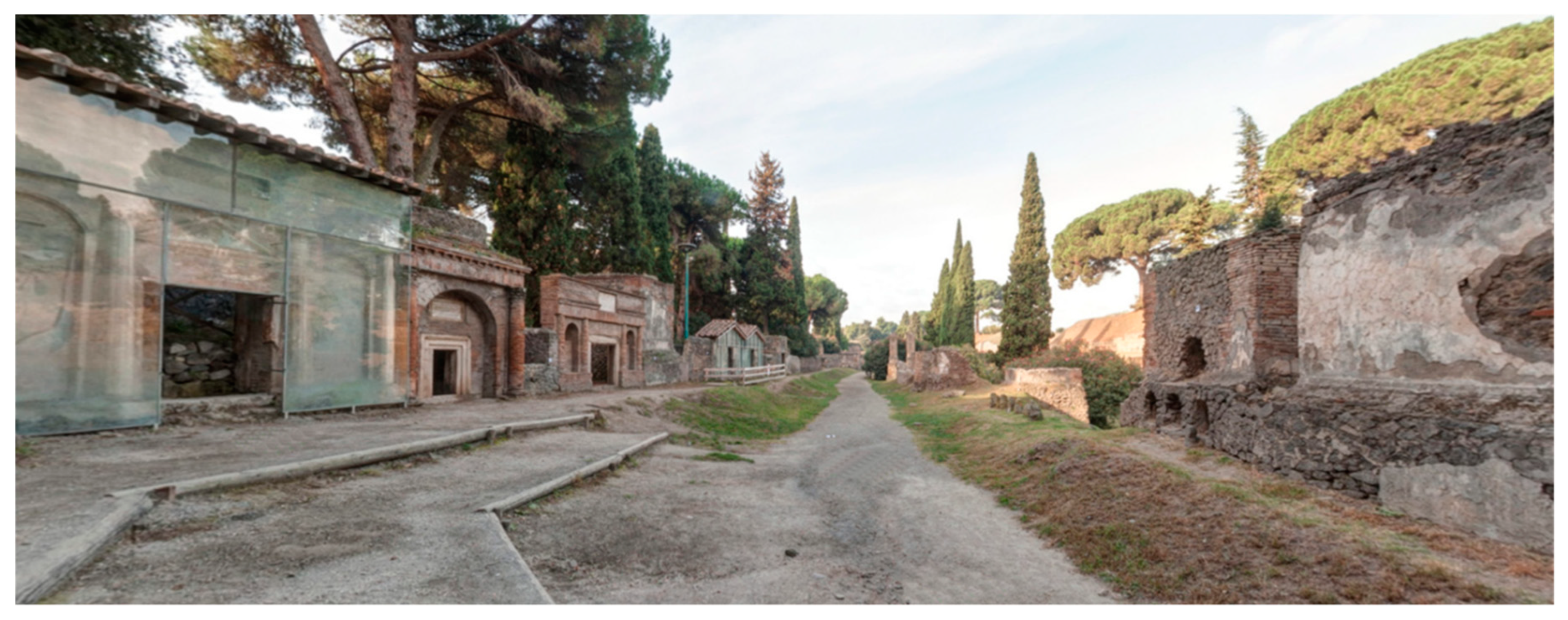
3. The Necropolis of Porta Nocera. The PSPP Case Study
The necropolis of Porta Nocera and the nearby area of Via Nucerina constitute a single funerary site, in addition to the five necropolises identified outside the city walls by the excavations conducted in Pompeii until now [
9]. The two sectors, located in the south-eastern area of the ancient city of Pompeii, were originally part of a single complex, alongside the extra-urban road leading from Porta Nocera to the town of the same name. Today, the two portions of the necropolis are separated by the current forecourt of the amphitheatre (
Figure 2).
The western sector was excavated by Amedeo Maiuri between 1954 and 1956 [
10], while the sector to the east was investigated by Antonio D’Ambrosio and Stefano De Caro in 1983 [
11]. The funerary ritual commonly performed in the necropolis was the cremation and the ashes of the deceased, whose bodies were burnt in pyres that were built near the tombs and were contained into urns which were often located inside funerary enclosures delimited by fencing walls or other boundary elements. A characteristic feature of the tombs in Pompeii and the neighbouring territory was the “columellae”, anthropomorphic steles with, sometimes, elements that indicated the sex or typical features of the deceased, which were set into the ground as markers for individual burials.
The two funerary sectors included a total of 73 enclosures, 15 areas enclosed by simple boundary walls, 12 areas with monumental facades and 6 with simple ones (
Figure 3). The funerary buildings belong to different architectural types. There are few “tomb chambers”, while “house-tombs” and “podium tombs” are more frequent, the latter built with one or more orders, in the form of aediculae, tetrapylon or tholos. Among all of them is the “exedra tomb” with a semi-circular plan datable to the Tiberian period and designed by Eumachia, priestess of Venus as a family tomb, mausoleums. Based on the chronological evidence acquired by the archaeological investigations, the development of the entire necropolis can be dated to between the final decades of the 1st century BC and 79 AD, when the city was destroyed.
The choice of working within the context of a necropolis was stimulating and interesting for various reasons. Although these two contexts have been investigated on several occasions since the middle of the last century, it is only in recent years that they have received adequate attention regarding the importance of the evidence preserved. In fact, these not only make it possible to reconstruct the technical-constructive aspects of the monumental evidence, but also to investigate important questions connected with multiple aspects of the political, social, cultural and economic life of the community that worked, lived and buried its people in the city [
12,
13,
14].
However, the great variety of funerary typologies, the presence of an enormous number of architectural elements, covering or decorative surfaces, the variety of materials used, the different causes of degradation, the previous restoration works themselves and the protection structures put in place during the life of the monument after its rediscovery constitute a set of elements open to multiple readings and countless experiments, but which always require a systematic collection and meticulous organisation of data, as well as their adequate preservation over time, so that, through the appropriate processes of analysis, it is possible to arrive at complete reconstructions. Only in this way can Amedeo Maiuri’s assertion about the discovery of the necropolis of Porta Nocera be realised, allowing us to learn about the world of the living through the tombs of the dead [
15]. The results obtained from the survey activity carried out within the PSPP not only provided a sufficiently precise reference base to support all the project activities but, thanks to the sharing of the same network of cornerstones allowed to enriched with multiple details the most recent cartography of the area.
4. Survey and Digital Reconstruction of the Porta Nocera Necropolis
An accurate and reliable survey of the area of the necropolis of Porta Nocera was an essential requirement for pursuing the objectives of the PSPP. All the information collected during the fieldwork, from the environmental investigations to the analysis of materials and construction techniques of any tombs, have in common the fact of belonging to the same physical place, and through this it becomes possible to investigate the contextual relationships and obtain, even in a dynamic way, useful information to build and keep updated complete knowledge that is capable of monitoring the state of conservation of the archaeological evidence in the area and support any actions of protection and conservation. Moreover, the availability of a digital representation of a three-dimensional physical space provides considerable advantages as a 3D model, with the association of descriptive data of its physical and spatial attributes, which can be used as a powerful tool to simulate the future effects of ongoing phenomena.
Fully conscious of this necessity and the potentialities implied in a digital model of the survey area, the research group of the ex IBAM-CNR of Catania, involved in the activities of the PSPP, carried out several survey campaigns in the area of the necropolis of Porta Nocera and the nearby sector of via Nucerina, to obtain an extremely precise three-dimensional digital model. It was also necessary to obtain a product that was compatible and therefore integrable with the most recent official cartographic representations, to obtain a result that could contribute to a better comprehension of the archaeological area in its entirety.
The most recent cartographic representation of Pompeii, in digital and georeferenced format, created in 2012 and released to the public in 2018 [
16], represents the latest achievement in a cognitive effort and representation of reality, the beginnings of which go back to the first excavation activities conducted under the bourbon dynasty. The survey activity, based on a primary and secondary topographic network distributed throughout the entire archaeological area and linked to an absolute reference system by a series of topographic reference points whose coordinates were acquired through DGPS, is extremely accurate for the area inside the city, but is lacking in the peripheral areas.
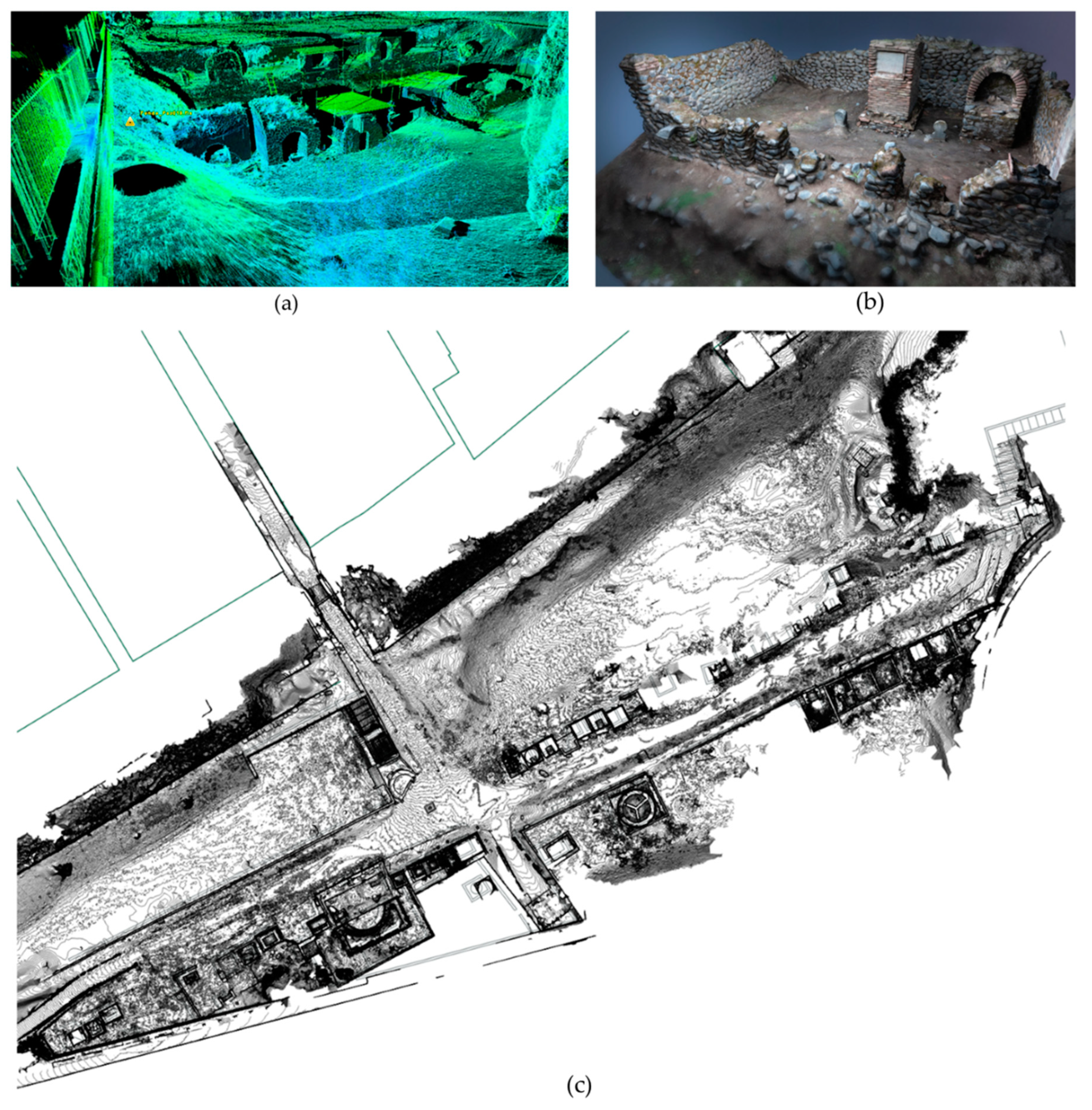
The survey activity carried out within the PSPP has integrated different methodologies and technologies. The first phase of the activity involved the thickening of the topographic network available in the area through the materialisation on the ground of further cornerstones appropriately distributed in the area of the necropolis of Porta Nocera and Via Nucerina, whose absolute coordinates were obtained through the use of DGPS. This provided the reference base for all subsequent survey activities, conducted by integrating laser scanners and photogrammetric surveys from the ground and with low-altitude drone shots.
The data collected, consisting of point clouds and collections of digital images, were subjected to a careful process of elaboration and integration that made it possible to obtain a three-dimensional digital model of extreme precision in the restitution of the spatial, dimensional and volumetric data, extended to cover both sectors of the necropolis and based on georeferenced point clouds with absolute coordinates and textured through the attribution of the chromatic data by the results of the photogrammetric surveys. This model allows, based on specific requirements, for us to obtain single 3D models of sections of the real object of interest, which can range from the geomorphology of the ground to the texture of a wall or the rendering of an architectural moulding.
The results obtained from the survey activity conducted as part of the PSPP not only provided a sufficiently precise reference base to support all the project activities, but thanks to the sharing of the same network of cornerstones it made it possible to enrich the most recent cartography of the area with multiple details (
Figure 4).
5. The Information System of the Pompeii Sustainable Preservation Project
The purpose of the Pompeii Sustainable Preservation Project’s information system is to collect and manage in an integrated manner all the data produced during the project, to facilitate both the processes of analysis and production of information and the sharing of acquired knowledge. Since the spatial attribute constitutes, as has been said, both the common denominator capable of bringing heterogeneous data back to a common factor and the main analysis tool, its correct management plays a central role in the information system which is created. At the moment, the system consists of two fundamental components: a database capable of managing different types of data together with the relative spatial attributes and a GIS platform for the presentation and analysis of the data.
Both components of the information system were designed and implemented by the writer using open-source software [
17]. For the realisation of the database, we used PostgreSQL, an open-source Object Oriented Relational Database Management System [
18] which not only represents an extremely reliable and mature product but also allows, through the PostGIS extension, complete management of the spatial data [
19]. The perfect and easy integration of PostgreSQL with QGis [
20], a desktop GIS software, also open source and now established on the international scene as a valid alternative to commercial solutions, has led to its adoption inside the project. The entire database currently resides on a server at the ISPC-CNR branch in Catania (ex IBAM-CNR) and is accessible remotely through appropriate forms of data entry and/or consultation directly through QGIS.
In designing and implementing an information system to manage data produced in the context of research activities conducted within the Pompeii archaeological site, it was impossible to ignore the fact that one of the aims of the Knowledge Plan of the Great Pompeii Project was the creation of an information system that, through the close combination of old and new data, considered in their exact spatial context, could generate the knowledge that is necessary to implement the planned prevention program that was the ultimate goal of the entire project [
21]. Indeed, it is easy to understand how, from this perspective, the creation of a tool capable of preserving and managing both archival data and those produced by the new research conducted as part of the GPP, represented a priority requirement. Meanwhile, at the same time, the integration of the information system of the GPP with SIGECWeb [
22], the General catalogue information system developed by the Italian Central Institute for Catalogue and Documentation (ICCD), with other databases and web platforms, such as the Information System for the Vesuvian Area (SIAV), certainly represented one of the most important aims among those included in the Knowledge Plan of GPP.
The design of the Information System of GPP has required to mediate between the opposing extremes of observance of norms and standards, according to the ICCD cataloguing system [
23], on the one hand, and the innovation on the other, that was necessary to find a space for recording the specific features of both the Pompeii site and the methodologies employed in the context of the GPP’s activities.
In this perspective, aimed in any case at the creation of an organic and coherent system for managing Pompeii’s archaeological evidence, from the urban scale to the individual wall elements, it was made a recourse, in designing the Information System of the GPP, to the catalogue schemas drawn up by the ICCD [
24]. The SI model (SIto archeologico/archaeological SIte) was used to archive two different levels of the ancient city, the site in its entirety and the divisions into regions. The CA model (Complesso Archeologico/Archaeological Complex), on the other hand, was used for the management of the insulae, while the MA model (Monumento Archeologico/Archaeological Monument), was used to express all the underlying levels, going from the single domus to its internal articulations based on the various rooms, to the walls and floors that represent its constituent elements.
The models that were just mentioned comprehensively cover the different types of material evidence present in the Pompeii archaeological site. In addition to these, there are additional ones through which it is possible to formalise the various types of intervention that may affect archaeological assets in the various ways described previously. The “Inspection”, “Diagnosis” and “Interventions” models together cover the entire range of actions that, with varying levels of intensity, from autoptic analysis to instrumental diagnosis, from excavation to restoration and from this to monitoring, may affect a sector of the city, an archaeological monument or a part of it.
In this case, the outline of the models also includes some elements derived from ones in use for some time by the ex-Superintendence of Pompeii. The list is completed by two descriptive models, for recording the stratigraphic units (US) and the wall technique (USM, USR), which in this case are based on the ICCD ones.
The scheduling system quickly described has been set up as the basis for the creation of a database, with geospatial extension, for data storage and management. Among the possible types of features, through which to give graphic expression to the elements that can have a spatial geographical definition, the “polygon” type was used for the characterisation of all the elements making up the site, whose thematic data, as mentioned, was structured based on the SI, CA and MA models. On the other hand, multi polygon geometry was used for the representation of the areas subject to inspection or excavation activities. The results of the stratigraphic investigation, the analysis of materials and construction techniques, as well as of the degradations conducted based on rectified photo plans associated with the different walls or floors elements, were expressed through the use of two-dimensional features, covering all the geometric primitives: point, polyline and polygon. Overall, the graphic translation of both the archaeological assets and the inspection, diagnosis and intervention activities is essentially based on a two-dimensional representation, while a future implementation of the platform for the management of the data through 3d models is hoped [
25].
In designing the PSPP’s information system, the starting point was, therefore, a detailed analysis of the cartographic records produced for the creation of the Knowledge Plan of the Great Pompeii Project, which constituted the absolute reference for the creation of a database that would be compatible with what had already been achieved through the collaboration between the Pompeii Archaeological Park and the ICCD, while at the same time making it possible to adapt to the specific needs and peculiarities of the PSPP’s data management and analysis.
The strategy adopted in this regard involved respect for the articulations with which the Great Pompeii Project’s information system was intended to manage the complexity of the archaeological evidence present on the site, from the whole urban area to the individual wall or floor elements. At the same time, the central role, which had been assigned in that model, was maintained to the “intervention”, as a tool for acquiring data and taking concrete action on the site. This central unit, constructed within the PSPP information system, respecting the articulation, codification and data present in the catalogue model of the information system of the Great Pompeii Project, represents the main means of communication between the two databases.
In addition to the models for the management of the spatial organisation and the subdivision of the individual archaeological findings into their constituent structural elements, which in the case in question made it possible to move from the funerary building to the single wall and covering surface, additional models were created for the archiving and management of data following the specific requirements and objectives of the PSPP. These data models make it possible to record data from a general level, characterising the entire project, to the registration of the individual survey campaigns and the activities carried out in each of them, including information on the individual researcher or technician involved and the institution to which they belong.
Each activity carried out and described based on the specific type of intervention (survey, technical analysis, non-invasive investigations, archaeological excavation, restoration), as well as maintaining a close link with the subjects and institutions involved—an issue that cannot be neglected in an international project, in which different research groups operate in the field—is further characterised by special detailed models, which make it possible to describe the methodologies and instruments used. In this structure, the individual activities, which can be perfectly integrated with the division into Inspections, Diagnoses and Interventions provided in the information system of the GPP, constitute the link between the human element performing specific actions on the site, whether of knowledge or concrete intervention, and the results achieved, the management of which has been the focus of the greatest efforts in the design and development of the PSPP information system.
These include a heterogeneous set of data: topographic and geophysical surveys, analysis of materials and construction techniques, environmental and microclimatic analyses, identification and mapping of structural degradations. For each of them, special descriptive tables have been drawn up which allow storage of the “raw” data, together with the information useful for the exact location in the physical space and an interpretative content. The integration of three-dimensional spatial data into the PSPP’s information system has followed two different paths, dictated by the necessity to balance the need for precision and accuracy in the rendering of spatial data (geographical, dimensional, volumetric) and surfaces with the limitations of remote visualisation, editing and analysis, which the system had to meet.
The main strength of the entire information system lies in the level of accuracy placed in the management of the spatial data, which has made use of the results obtained through the different surveys carried out.
The first level of integration has been achieved by creating individual geographical layers, starting from the subdivision of the general point cloud of the entire funeral area into smaller portions that have subjected appropriate simplification processes and include the individual funeral building together with the immediate spatial context. Through this solution, it was possible to obtain a very precise reference base of the physical space and individual funeral buildings directly within the GIS environment.
The second level of integration was achieved by creating three-dimensional models of each funeral building, made from the laser scanner and photogrammetric surveys. These models, which can be accessed via links from the GIS platform, are particularly useful whenever there is a need for a visualisation tool capable of providing a highly detailed rendering of the coating surfaces.

