1. Introduction
Dissemination of archaeological and historical research is a complex task because it relies on the final product of the research itself and not on the process, which is, on one hand, less “fashionable” and shareable. For this reason, participatory models are important and can help in the creation of both local awareness and shared knowledge. This paper will display three case studies in which the participatory process has been applied with three different approaches: in the first case, a broad anthropological approach; in the second, a time-framed archaeological approach; in the last case, a spatial-framed approach. The impact and methodology for these three approaches are very different but the outcome is similar: collaborative local community building of shared knowledge.
Since 2016, the Trentino Alto Adige Wiki group, made up of volunteers active on the Wikimedia projects, has organized a series of editathons in collaboration with local museums and cultural institutions. During these events, Wikipedians, experts in specific fields and passionate end users worked together in order to implement the presence of quality content in Wikimedia projects. This type of event is organized mainly (but not only) in museums. A guided tour usually takes place during the first part of the day, while, at a later time, the participants work on Wikimedia projects.
The events organized in Trentino Alto Adige between 2016 and 2018 are:
Museo Diocesano Tridentino (Trento, 14 September 2016 and 17 June 2018).
Museo Caproni (Trento, 27 August 2016).
Museo degli Usi e Costumi della Gente Trentina (San Michele all’Adige, 17 June 2017).
Museo Diocesano Tridentino (Villa Lagarina, 27 May 2017).
Museo Casa Degasperi (Pieve Tesino, 29 July 2017).
Editathon Imago Animi (Cles, 16 June 2018).
Edithaton Archeologia della Grande Guerra (Livo, 8 December 2018).
Usually, an editathon in a museum makes available data that can be used to improve the contributions of several platforms, of which the main ones are:
Wikipedia, a free, collaborative and multilingual encyclopedia and the most famous of the Wikimedia projects.
Wikimedia Commons, a repository of multimedia files published under free licenses.
OpenStreetMap, a free and collaborative map.
Two of the three editathons of 2018, herein discussed and analyzed, were organized in partnership with Arc-Team, on the occasion of two different exhibitions: “Imago animi. Volti dal passato” [
1], held in Cles (Trentino, Italy), and the archaeological section of “Val di Non. Sguardi sulla Grande Guerra” [
2], held in Livo (Trentino, Italy).
These two events were organized in close contact with the researchers who set up the two exhibitions, without failing to respect the rules of the wiki community (e.g., encyclopedicity of the articles, verifiability of the sources).
The third editathon was the “MappatOHM”, a mappathon and editathon organized by OpenHistoryMap in Bologna. The activities spanned three days between April and May and saw the cooperation between volunteers and researchers of University of Bologna.
2. Editathon Imago Animi
The event “Imago animi” [
3], was a development of the open-source exhibition “Facce. I molti volti della storia umana” [
4], held in Padua in 2015, which was in turn derived by the open research study “Taung Project” [
5].
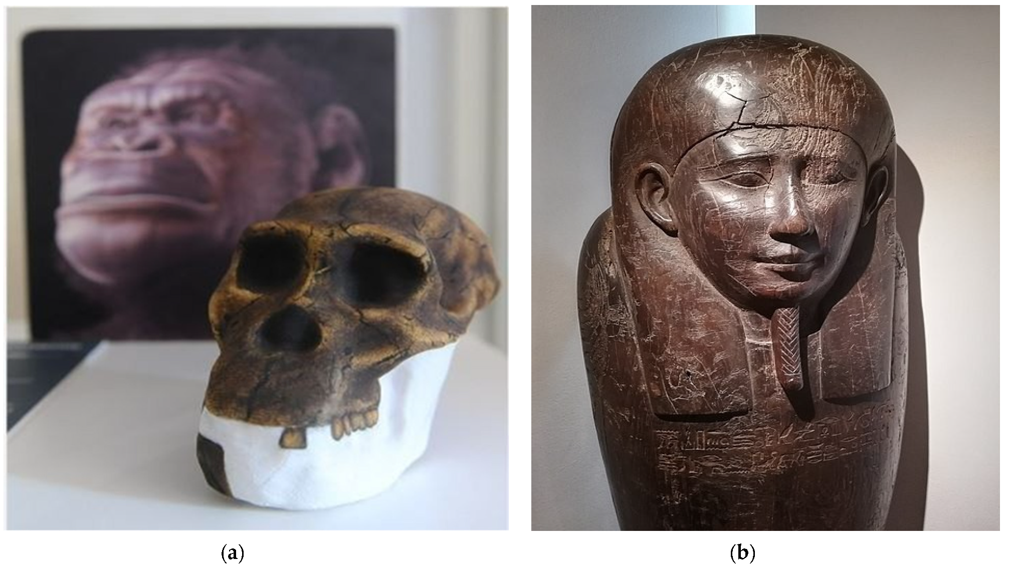
The main topic of this exposition was centered on the human face, analyzed in six sections, through different points of view. The exhibition itinerary started with human evolution, showing some paleo-artistic facial reconstructions of the most important hominids (
Figure 1a), performed with the consistent anatomical deformation technique [
6]. Then, the visitor was introduced to the theme of racism and so-called scientific racism, which was a part of common Western thinking until the end of the Second World War. This section was designed to show the scientific inconsistency of the concept of races within the human species. Continuing with the itinerary of the exhibition, the visitor entered three rooms dedicated to the topic of forensic facial reconstruction, with the possibility to see the aspect of five personalities from the past: the Ptolemaic mummy of the first priest of Thot (
Figure 1b), the poet Francesco Petrarca, St. Anthony of Padua, St. Pauline Visintainer and the Cardinal Bernardo Clesio. The fourth section was focused on the symbolic meaning of hiding the face behind a mask, with an ethnographic collection from Europe, Africa and Oceania. Finally, the exhibition ended with an art section with portraits of modern artists, including James Brown, Luigi Ontani and Ron Gorchov.
The editathon dedicated to the exhibition “Imago animi” involved six participants, four of whom were already experienced, while two were new users. During the editing work, which took place after a guided tour led by members of the Arc-Team, two new articles were created (it.wiki), five articles were substantially implemented (it.wiki) and 45 files were uploaded in Wikimedia Commons (Category: Editathon Imago Animi—June 2018 [
7]).
Given the success in sharing open knowledge of this first event, a new editathon was organized in partnership between the Arc-Team and the Trentino Alto Adige Wiki group, this time focusing on a new topic: the archaeology of the Great War.
3. Editathon Archaeology of the Great War
The exhibition “Archeologia della Grande Guerra”, held in Livo during winter 2018, was the archaeological section of the widespread exhibition “Val di Non.
Sguardi sulla Grande Guerra”, dedicated to the topic of Great War in Non Valley (Trentino, Italy).
The itinerary started with an introduction to the general concept of conflict archaeology, with a specific focus on the First World War. In the room of the ground floor, artifacts were displayed coming from Non Valley and dating back to the period 1914–1918. The last room of this first section was dedicated to the virtual 3D reconstruction of one of the main examples of military architecture of this territory: the Rocchetta roadblock [
8]. On the contrary, the first floor, focused on modern conflict archaeology as a discipline [
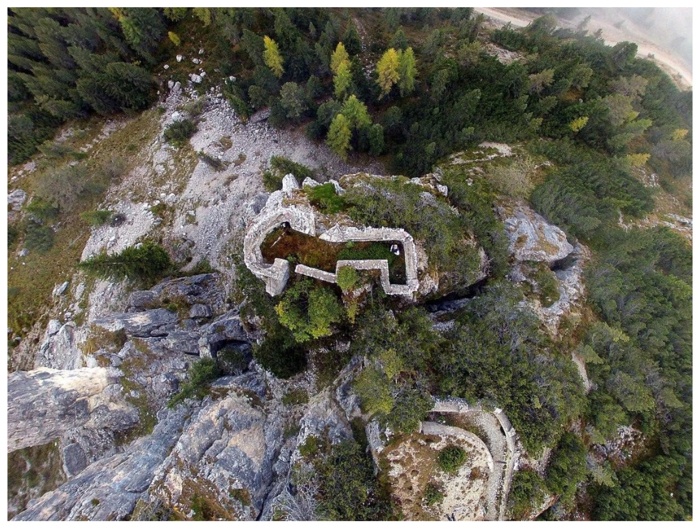
9], analyzed the fieldwork from a logistical perspective in the involved sub-disciplines, such as aerial archaeology (
Figure 2), glacial archaeology, high mountain archaeology, speleoarchaeology and underwater archaeology. In this particular section, some exemplary case studies were also presented, such as the mission on the so-called “devil’s boat” [
10] in the Mandrone lake at 2409 meters above sea level, or the 3D documentation of the tunnel system of Doss Alto, near the Garda Lake [
11].
The editahon related to the exhibition “Archeologia della Grande Guerra” [
12] took place on December 2018. After the visit, the editing started with the help of nine participants, including a new user. During the event, a new article was written in German (de.wiki) and three new articles in Italian (it.wiki). Moreover, 163 files were uploaded on Wikimedia Commons (Category:Archeologia della Grande Guerra a Livo—dicembre 2018 [
13]) and to update the data about Livo in OpenStreetMap.
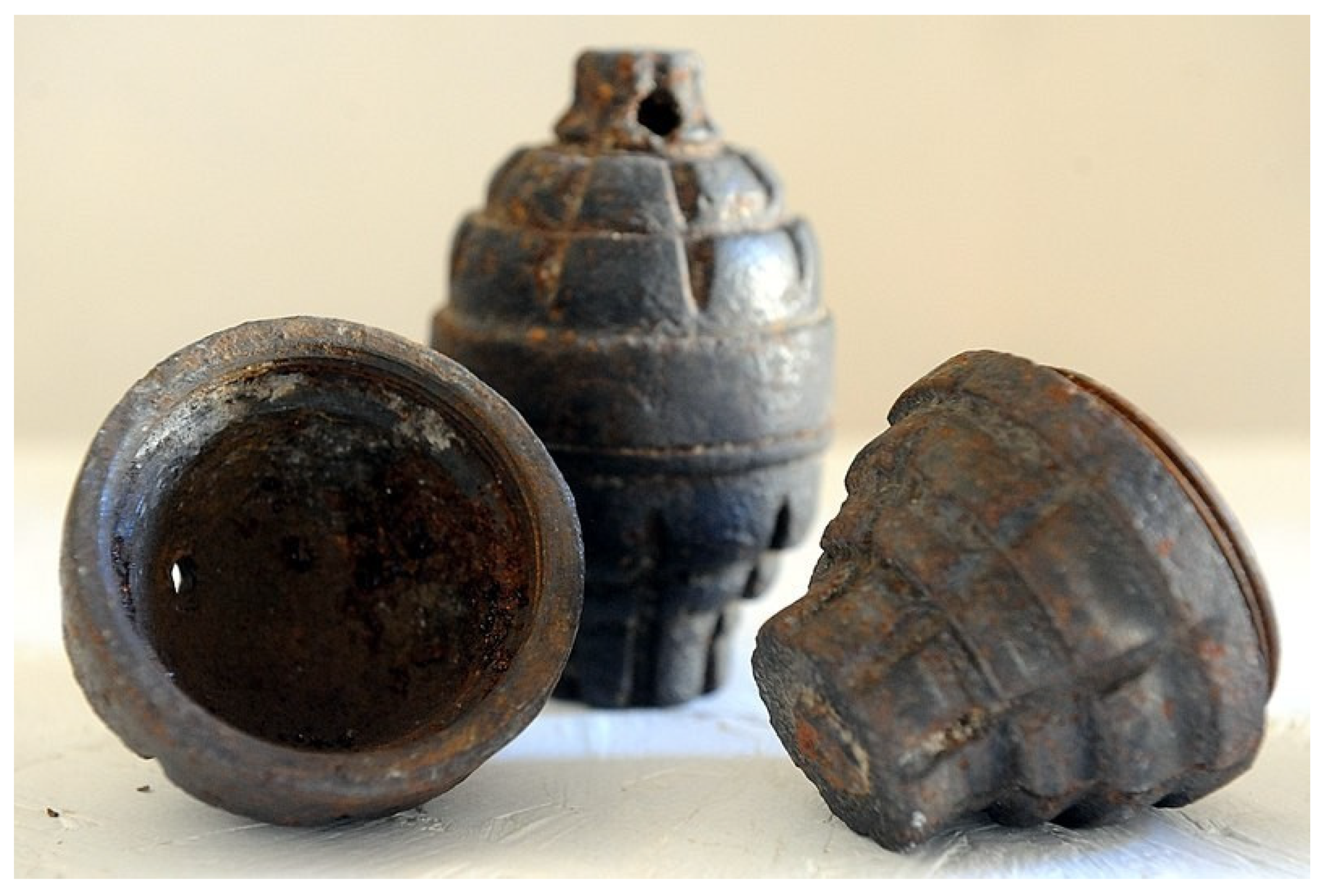
This second experiment in sharing archaeological and cultural open data through wiki platforms gained more visibility than the first event (“Imago animi”). The second event was probably more useful in building a shared knowledge due to better preparation as a result of the acquired experience from the previous event. Indeed, some of the collected photos were particularly useful to improve the specific related articles in
Wikipedia, like the ones dedicated to the SIPE [
14] or Besozzi [
15] grenade (
Figure 3). The last one, in particular, has been enriched with a new photo which “has been assessed under the valued image criteria and is considered the most valued image on Commons within the scope: Besozzi hand grenade” [
16].
4. Open History Map and Location-Framed Editathons
The third case of study relates to a location-framed editathon. As previously seen, data created through historically accurate reconstructions of our past enable the elaboration, reuse and creation of value in the various large knowledge sharing platforms such as Wikimedia and OpenStreetMap. This also opens opportunities for less common ones as well, such as OpenHistoryMap.
This organization was founded in Bologna with the aim to build a shared open data visualization platform for historical datasets, enabling the user to explore the world of the past with modern tools and approaches. This goes beyond a pure vertical GIS, and focuses on offering a new experience, based on the understanding of the main changes in history. OpenHistoryMap organized three editathons, called MappatOHM, in an effort to create a series of interactions with potentially interested users as well as passers-by and visitors curious about local history.
The MappatOHM experience in Bologna was very positive. There were three events in 2018, between April and May, that considered the history of the “zona U”, an area composed of the historical university area of the city center, starting in Via Zamboni and covering the first streets stemming from there as well as part of the nearby Via Belle Arti. The area covers the ancient core of the oldest university in the Western world and, aside from this great educational importance, it has a complex history spanning more than 900 years. The choice of the area was driven by the municipality, considering that the editathons were organized within the European H2020 project “Rock”.
The first MappatOHM covered the present and the awareness of the city towards its own history. The participants were divided into groups in order to explore the area and gather information about the current cultural workshops, galleries and stores within the nearby artist/artisan area of Via Belle Arti. The information was collected into customized field papers that contained both data from OSM and open data published by the municipality. The result of such an operation is double: on one side there is a better understanding of the territory through the exploration, and on the other there is a better understanding of what the municipality already knows and owns and what processes the municipality is applying to grow the value of the area itself.
The second MappatOHM covered the past and saw the collaboration of Eng. Garagnani, a Professor at University of Bologna specializing in digital heritage. With his guidance, the participants recognized the same area previously seen with the modern-day view using the insight of the history of the area and the changes in the buildings and in the wider landscape. The resulting editathon brought updates to both OSM and Wikipedia as well as several subjects for Wikimedia Commons. Moreover, the collected data were prepared as a structured table to be imported into the timeline and map of the OHM project.
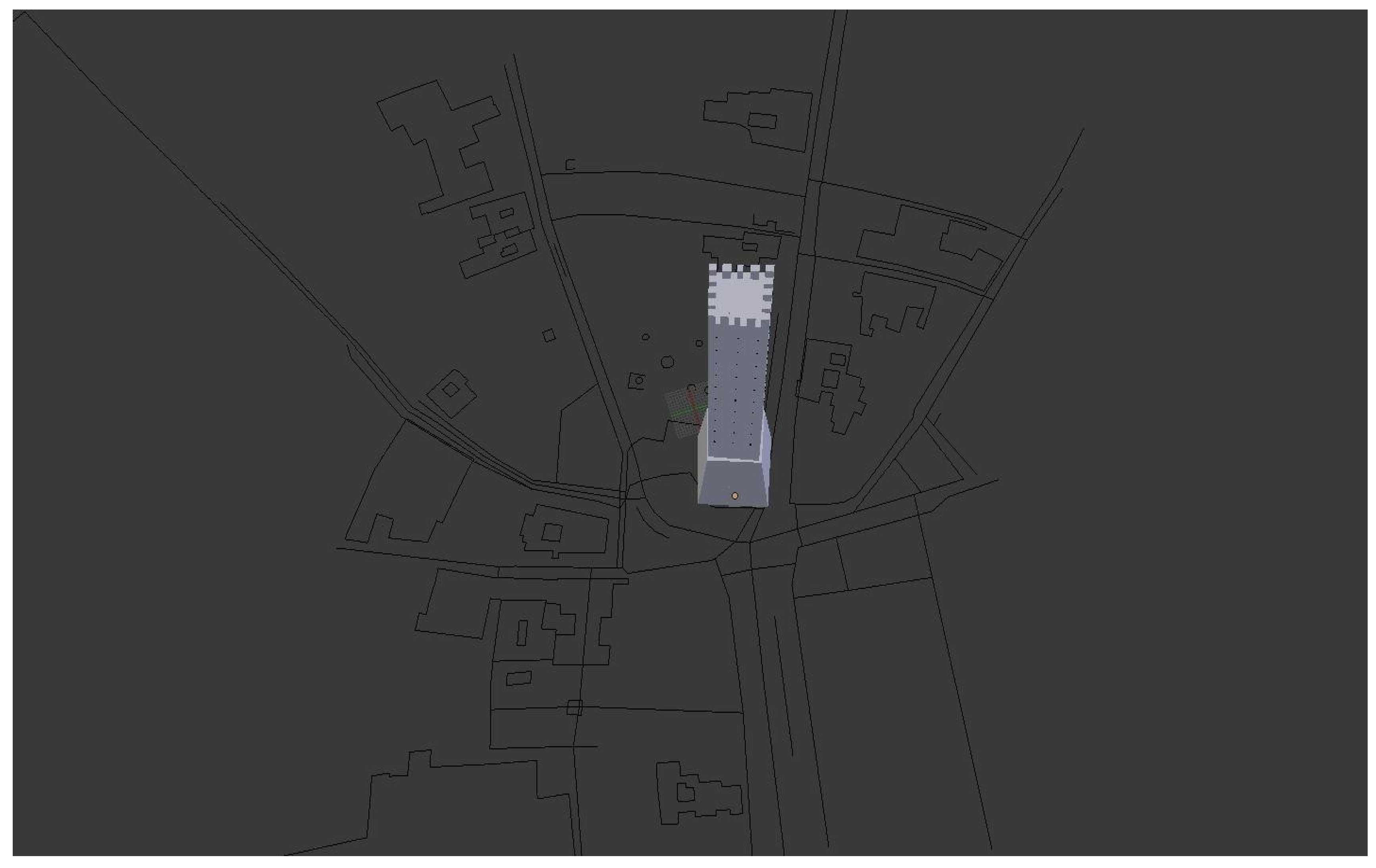
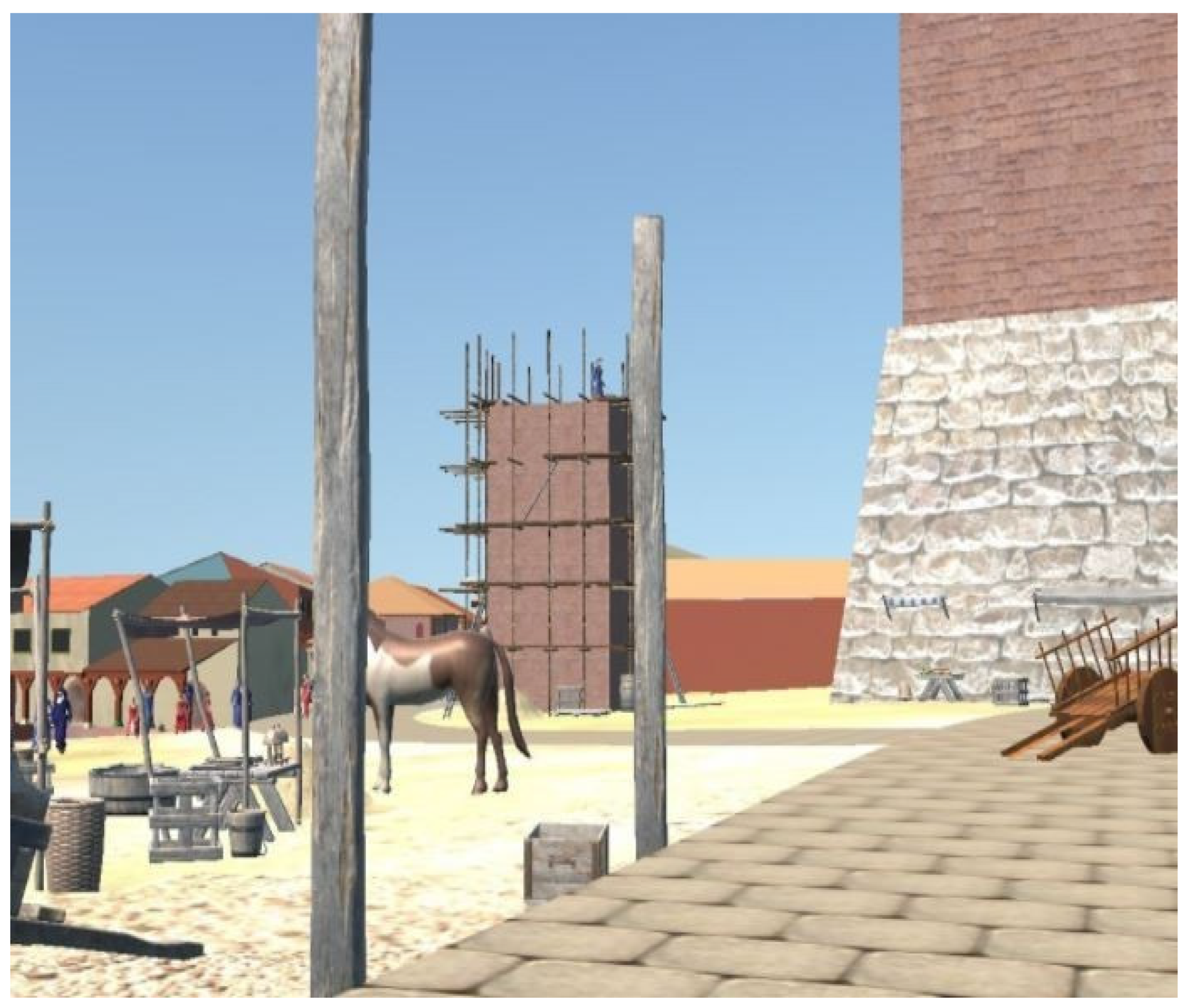
The third and last MappatOHM had the main objective to use the past experiences and to return a result to the community in the form of a VR application. From this perspective, the data collected during the previous editathons were integrated with a 3D reconstruction of the city center (
Figure 4) in a very specific time frame, restricted to 1115 A.D. This year is very important for what is the city center of Bologna today, part of the “zona U”. Indeed, in 1115 A.D., the imperial castle of Matilde di Canossa was just destroyed, the Garisenda tower was built and Asinelli was under construction during the urban expansion just outside the “Porta Ravegnana” (one of the two main doors to the city on the Via Aemilia in the direction of Rimini and Ravenna;
Figure 5).
Although part of the work had been conducted outside of the operations of the editathons, like the 3D reconstruction of the main buildings, the sources found during the events, the data collected, and the images loaded into Commons were key elements in the definition of the details of the final product. Some examples of this combined reconstructive workflow are the 3D scenes describing the building process of a tower (applied to the reconstruction of Torre Asinelli, displayed in construction with scaffolding), the detailed presence of rivers crossing the modern city center and the relic structures of the rare elements of the cities remaining from that time (two of Santo Stefano’s Seven Churches).
5. Conclusions
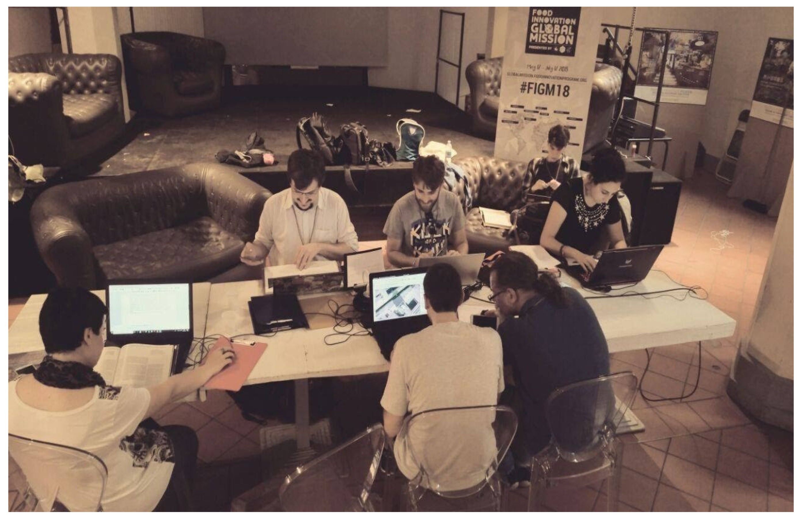
Based on our experiences (
Figure 6), the outcome of participatory models in archaeology has several advantages. On one side, it favors the dissemination of the results of studies and research that would be inherently complex to share outside of a classic scientific paper. On the other side, the data loaded into knowledge sharing platforms improve the average information quality, enabling precise and detailed information storage and helping other researchers and passionate users in their search for reliable sources. As a third positive outcome, the use of these platforms favors the reuse of the data in new forms that cannot be predicted before the creation of the dataset itself. This evident fact generates a secondary dissemination that, although uncontrolled, increases the possibilities of spreading knowledge and awareness about the projects themselves. Finally, the participants gain a better knowledge of their own surroundings.
Author Contributions
Conceptualization, L.M. and L.B.; methodology, L.M., M.M., A.B. and L.B.; software, M.M.; validation, Wikipedia community; formal analysis, L.M., M.M., A.B. and L.B.; investigation, L.M., M.M., L.B. and A.B.; resources, L.M., M.M., L.B. and A.B.; data curation, L.M., M.M., L.B. and A.B.; writing—original draft preparation, L.M.; writing—review and editing, L.B.; visualization, L.M., M.M., L.B. and A.B.; supervision, L.M.; project administration, L.M.; funding acquisition, L.M. All authors have read and agreed to the published version of the manuscript.
Funding
This research received no external funding.
Institutional Review Board Statement
Not applicable.
Informed Consent Statement
Not applicable.
Conflicts of Interest
The authors declare no conflict of interest.
References
- Bezzi, L.; Carrara, N.; Nebl, M.; Animi, I. Volti dal Passato, 1st ed.; Municipality of Cles: Cles, Italy, 2018. [Google Scholar]
- Bezzi, L.; Bezzi, A.; Gietl, R.; Feistmantl, K.; Naponiello, G. Archeologia della Grande Guerra. In Val di Non. Sguardi sulla Grande Guerra, 1st ed.; Postal, G., Ed.; Comunità della Val di non: Cles, Italy, 2018; pp. 14–37. [Google Scholar]
- Wikipedia:Raduni/Editathon Imago Animi. Available online: https://it.wikipedia.org/wiki/Wikipedia:Raduni/Editathon_Imago_Animi (accessed on 15 March 2021).
- Bezzi, A.; Bezzi, L.; Moraes, C.; Carrara, N.; Pievani, T.; Tiziani, M. Facce. I molti volti della storia umana. Una mostra Open Source. In Proceedings of the ArcheoFOSS. Free, Libre and Open Source Software e Open Format nei Processi di Ricerca Archeologica—Atti del IX Workshop, Verona, Italy, 19–20 June 2014; Caravale, A., Basso, P., Grossi, P., Eds.; All’Insegna del Giglio: Florence, Italy, 2016; pp. 271–279.
- Bezzi, A.; Bezzi, L.; Moraes, C.; Carrara, N.; Tiziani, M. Analisi di uno studio Open Source: Il Taung Project. In Proceedings of the ArcheoFOSS. Free, Libre and Open Source Software e Open Format nei Processi di Ricerca Archeologica—Atti del l’VIII Workshop, Catania, Italy, 18–19 June 2013; Stanco, F., Gallo, G., Eds.; Archeopress: Oxford, UK, 2016; pp. 230–239. [Google Scholar]
- Bezzi, L. FACCE. I molti volti della storia umana. BIM 2016, 18, 10–13. [Google Scholar]
- Category:Editathon Imago Animi—June 2018. Available online: https://commons.wikimedia.org/wiki/Category:Editathon_Imago_Animi_-_June_2018 (accessed on 15 March 2021).
- Bezzi, L.; Bezzi, A.; Gietl, R.; Moraes, C.; Naponiello, G. La Tagliata della Rocchetta: La ricostruzione digitale di un forte della grande guerra. APM 2018, 22, 107–117. [Google Scholar]
- Bezzi, L.; Bezzi, A.; Gietl, R.; Naponiello, G.; Feistmantl, K. Archeologia del conflitto moderno: Un approccio alla disciplina basato sulla field archaeology. APM 2018, 22, 57–70. [Google Scholar]
- Bezzi, L.; Bezzi, A.; Camagna, T.; Gietl, R. La barca dei diavoli: Un relitto della Grande Guerra a 2409 m di altitudine. APM 2018, 22, 119–128. [Google Scholar]
- Bezzi, L.; Gietl, R.; Bonfanti, F.; Bezzi, A.; Naponiello, G.; Feistmantl, K. La Grande Guerra sul Garda orientale. Un progetto di archeologia del conflitto. In La Grande Guerra sul Garda Orientale. Operazioni Belliche e Vicende Militari sul lago e L’entroterra Montano, 1st ed.; Bonfanti, F., Ferrari, R., Eds.; Edibus: Vicenza, Italy, 2018; pp. 173–2017. [Google Scholar]
- Wikipedia:Raduni/Archeologia della Grande Guerra Editathon a Livo. Available online: https://it.wikipedia.org/wiki/Wikipedia:Raduni/Archeologia_della_Grande_Guerra_editathon_a_Livo (accessed on 15 March 2021).
- Category:Archeologia della Grande Guerra Editathon a Livo—Dicembre 2018. Available online: https://commons.wikimedia.org/wiki/Category:Archeologia_della_Grande_Guerra_editathon_a_Livo_-_dicembre_2018 (accessed on 15 March 2021).
- SIPE. Available online: https://it.wikipedia.org/wiki/SIPE (accessed on 15 March 2021).
- Besozzi (granata). Available online: https://it.wikipedia.org/wiki/Besozzi_(granata) (accessed on 15 March 2021).
- File:Granate Besozzi WWI.jpg. Available online: https://commons.wikimedia.org/wiki/File:Granate_Besozzi_WWI.jpg (accessed on 15 March 2021).
| Publisher’s Note: MDPI stays neutral with regard to jurisdictional claims in published maps and institutional affiliations. |
© 2021 by the authors. Licensee MDPI, Basel, Switzerland. This article is an open access article distributed under the terms and conditions of the Creative Commons Attribution (CC BY) license (https://creativecommons.org/licenses/by/4.0/).
