Article

Research on Grassland Fire Prevention Capabilities and Influencing Factors in Qinghai Province, China

1
College of Geographic Sciences, Qinghai Normal University, Xining 810008, China
2
School of National Safety and Emergency Management, Qinghai Normal University, Xining 810008, China
3
Academy of Plateau Science and Sustainability, Qinghai Normal University, Xining 810008, China
4
Qinghai Remote Sensing Center for Natural Resources, Xining 810001, China
*
Authors to whom correspondence should be addressed.
Earth 2025, 6(3), 101; https://doi.org/10.3390/earth6030101
Submission received: 30 July 2025 / Revised: 19 August 2025 / Accepted: 21 August 2025 / Published: 22 August 2025

Abstract

Frequent grassland fires have severely affected regional ecosystems as well as the production and living conditions of local residents. Grassland fire prevention capabilities constitute an integral part of the disaster prevention and mitigation system and play an important role in improving grassroots governance. To gain a deeper understanding of the practical foundation and influencing mechanisms of grassland fire prevention capabilities, establish an evaluation index system for prevention capabilities covering the four dimensions of disaster prevention, disaster resistance, disaster relief, and recovery. Combining micro-level survey data, a quantile regression model is used to analyze the influencing factors. The research findings indicate that (1) disaster resistance (0.49) plays a prominent role in grassland fire prevention capabilities, with economic foundations and individual disaster relief capabilities being particularly critical for overall improvement. Although residents have strong fire prevention awareness, their organizational collaboration capabilities are relatively weak, and there are significant differences in prevention capabilities across regions, necessitating tailored, precise enhancements. (2) There are significant differences in prevention capabilities among residents of different agricultural and pastoral production types, with semi-agricultural and semi-pastoral areas having the strongest comprehensive capabilities and pastoral areas relatively weaker. (3) A significant analysis of factors influencing grassland fire prevention capabilities: effective and diverse risk communication is a prerequisite for enhancing residents’ prevention capabilities; the level of panic regarding grassland fires and road infrastructure are important influencing factors, but residents’ understanding of climate change and grassroots organizations’ capacity for mechanism construction have insignificant impacts. Therefore, in future grassland fire disaster prevention and mitigation efforts, it is essential to strengthen risk communication, improve infrastructure, monitor environmental changes and the spatiotemporal patterns of grassland fires, enhance residents’ understanding of climate change, reinforce the emergency response capabilities of grassroots organizations, and stimulate public participation awareness to collectively build a multi-tiered grassland fire prevention system.

1. Introduction

The Qinghai–Tibet Plateau functions as a crucial ecological security barrier and water conservation area in China. Grassland ecosystems play a pivotal role in sustaining the region’s long-term development. High altitude, low temperatures, an arid climate, and fragile ecological structures [1] pose significant challenges for grassland fire prevention and control. Fires occur frequently and spread rapidly, while post-fire recovery is considerably more difficult than in low-altitude areas. Although global grassland fire issues have been widely examined [2], systematic assessments of residents’ fire prevention capabilities on the Qinghai–Tibet Plateau remain limited. Current research is hindered by challenges such as restricted data accessibility and variable quality. The vast expanse and sparse population of the Qinghai–Tibet Plateau, coupled with communication difficulties, make it nearly impossible to obtain detailed data on disaster impacts and recovery [3]. This limitation complicates the validation of assessment results. Disaster prevention and mitigation assessments are often constrained by small sample sizes and inadequate survey indicators. In addition, the diversity of indicator systems reduces the comparability and consistency of assessment outcomes. Therefore, the scientific assessment and analysis of residents’ disaster prevention capabilities constitute a major focus and challenge in current research. This situation not only hinders a comprehensive understanding of regional disaster risks but also restricts the development of targeted disaster prevention and mitigation policies.
Countries abroad began exploring disaster prevention, mitigation, and relief much earlier. Nations such as the United States and Japan have enacted comprehensive disaster prevention and mitigation legislation, including unified fundamental laws and specialized regulations, thereby establishing cross-regional collaborative response systems and enhancing risk governance mechanisms [4]. Addressing natural disaster risks, fostering harmonious coexistence between humans and nature, and advancing the coordinated development of society, the economy, and the environment are not only pressing tasks for national development but also integral components of national security strategy [5]. Qin Lianxia [6] and Shen Long [7] have examined disaster risk assessment and emergency management frameworks in countries including the United States, Japan, and Canada. They emphasize that China should approach meteorological disaster prevention and mitigation with a strategic vision, advance the institutionalization and standardization of relevant systems, and extract strategic-level insights to provide valuable references for improving China’s disaster governance capacity.
Contemporary research, both domestic and international, primarily focuses on developing indicator systems and evaluation frameworks to quantitatively assess systemic disaster prevention capacity [8]. The construction of these systems is often informed by scholars’ disciplinary backgrounds and professional expertise. For example, Zhou Jinfeng [9] and Zhao Xin [10] incorporate indicators such as marine aquaculture area and the number of fishing vessels to assess disaster impacts on coastal fishing communities, while You Zhen [11] and Guo Tengjiao [12] apply indicators such as arable land area and low-lying regions to evaluate land-use vulnerability. With the advancement of risk assessment research, scholars across disciplines have developed customized indicator systems that reflect diverse research scopes, temporal dimensions, and regional specificities. Song Chao [13], Guo Tengjiao [14], and Bo Mingyang [15] have developed evaluation frameworks respectively targeting mudslides, storm surges, and compound hazards involving rainfall and heatwaves, and have proposed corresponding quantitative methodologies. Hasan [16] and Min Li [17] have explored disaster risk reduction strategies and planning measures within residential settings. These studies provide research ideas for risk assessment, but most focus on disasters such as storm surges, floods [18], heavy rainfall, and heat waves [15], with relatively little exploration of grassland fires.
As urban populations continue to rise, disaster-resilient green spaces are increasingly recognized as essential components of urban resilience. Studies have shown that in densely populated areas, fragmented and isolated green spaces provide limited resilience benefits [19]. For example, despite its high green space coverage ratio, Wuhou District experiences uneven distribution and insufficient infrastructure [20]. The case of Wuhan Zhongshan Park highlights the significance of spatial renovation in enhancing park-level disaster mitigation functions [21]. International research emphasizes that pre-disaster planning and the recovery of infrastructure systems are critical to effective post-disaster response. In addition, community collaboration and other “soft systems” serve as fundamental supports for strengthening resistance capacities [22,23,24]. Given the complex and multifaceted nature of urban systems, both domestic and international scholars have approached the design of urban disaster prevention frameworks from diverse dimensions. Seminal work by Bruneau introduced the TOSE framework—addressing technical, organizational, social, and economic aspects of community earthquake resilience [25]. Shaw’s Climate Disaster Resilience Index (CDRI) [26,27] incorporates five dimensions, including natural and physical factors, while Cutter developed the Benchmark Resilience Indicators [28], covering social, economic, and other resilience-relevant domains. Building on these foundations, Chinese scholars [29,30,31,32] have localized and extended these frameworks by integrating socio-ecological perspectives and cloud modeling approaches to optimize evaluation methodologies, refine indicator selection and weighting schemes, and diversify strategies for enhancing systemic resistance. However, most existing studies have been conducted at the urban scale, whereas research at the township, village, and household levels remains relatively scarce [33]. Moreover, such studies often lack practical applicability in rural, pastoral, and particularly highland grassland environments.
In disaster prevention and mitigation research, common methods such as ordinary least squares regression (OLS) [34], geographically weighted regression (GWR) [35], and robust regression [36] are frequently employed to analyze overall trends in disaster prevention and mitigation capabilities. However, these methods are more appropriate for explaining average effects and cannot adequately capture the heterogeneity of influencing factors across different levels of disaster prevention capabilities. The Qinghai–Tibet Plateau, characterized by pronounced socioeconomic disparities, shows marked heterogeneity in residents’ disaster prevention capabilities. Individuals engaged in different types of agricultural and pastoral production often exhibit varying levels of capacity. Exclusive reliance on mean regression may obscure the vulnerability characteristics of disadvantaged or marginalized groups. Quantile regression models [37,38,39] not only reveal overall trends but also capture differentiated mechanisms across different quantiles. This approach provides a novel analytical perspective for assessing grassland fire prevention capabilities.
Against the backdrop of global climate change, the frequency and intensity of extreme wildfires have increased steadily worldwide. However, systematic research on high-altitude grassland fires remains limited. In this context, this study focuses on Qinghai Province as the research area and considers grassland residents as the research subjects. It develops an evaluation index system for disaster prevention capabilities encompassing four dimensions: disaster prevention, disaster resistance, disaster relief, and recovery. Drawing on micro-level survey data, the study evaluates the level of grassland fire prevention capabilities among Qinghai residents engaged in different agricultural and pastoral production types. A quantile regression model is employed to analyze the key factors influencing grassland fire prevention capabilities. The objectives are to strengthen Qinghai Province’s disaster prevention and mitigation strategies, reveal differentiated mechanisms among resident groups, and broaden the international perspective on disaster prevention research.

2. Materials and Methods

2.1. Overview of the Study Area

Qinghai Province, located in the northeastern section of the Qinghai–Tibet Plateau, is one of China’s five principal pastoral regions. It contains approximately 421,333 square kilometers of natural grassland, accounting for 60.47% of the province’s total land area, thereby making grasslands the predominant ecosystem [40]. The province features a general topographical gradient, with lower elevations in the southeast and higher elevations in the northwest, and a terrain interwoven with mountains, plateaus, and basins. Qinghai experiences a plateau continental climate, marked by long and severe winters, strong winds during spring and winter, and a brief summer characterized by simultaneous heat and rainfall. Annual precipitation declines from southeast to northwest, while evaporation increases in the opposite direction. These gradients result in relatively favorable hydrothermal conditions in the east, which has consequently developed into a densely populated region and a core zone for agricultural production. In contrast, the western areas, constrained by harsh environmental conditions, are sparsely populated and primarily reliant on livestock husbandry. Influenced by high elevation, complex geomorphology, and climatic heterogeneity, Qinghai hosts extensive and ecologically diverse grassland ecosystems. These include alpine grasslands, temperate grasslands, desert grasslands, meadows, and marshlands (Figure 1), which are broadly distributed across the province. Overall, the spatial structure of agriculture and animal husbandry in Qinghai follows a distinctive pattern—agriculture in the east, pastoralism in the west, and an integrated agro-pastoral mosaic in the central regions—where combined farming and herding systems constitute the predominant mode of livelihood.
In 2022, the total output value of Qinghai Province’s agriculture, forestry, animal husbandry, and fisheries was approximately CNY 52.853 billion, of which the total output value of animal husbandry was CNY 29.857 billion, accounting for approximately 56.49%. However, grassland fires pose a serious threat to ecosystems, the livelihoods of herders, and regional sustainable development [41,42]. For example, in 2010, a grassland fire in Xiaoda Wa Village, Henan County, caused by fireworks, burned an area of 21.01 hectares, resulting in approximately CNY 30,000 in economic losses; in 2021, a fire in Daji County destroyed 1500 acres of grassland; In 2010, a fire in Kesheng Township, Henan County, caused by herders burning incense, resulted in a burned area of 21.68 hectares. Grassland fires lead to ecological degradation, resulting in reduced biodiversity, weakened carbon sequestration capacity, damage to livestock farming, feed shortages, and increased restoration costs, placing dual pressure on both the ecosystem and the economy. The fire-prone environments of alpine grasslands in the Qinghai–Tibet Plateau’s cold permafrost regions and temperate grasslands in Inner Mongolia are fundamentally different. While both have surface fires, alpine grasslands also have conditions conducive to underground fires, leading to diverse and complex fire patterns. However, Qinghai Province’s grassland fire prevention and control capabilities remain weak: there is a lack of an efficient monitoring and early warning system [43], and the vast expanse of grasslands with sparse populations makes it difficult to detect fires in a timely manner; professional firefighting forces are insufficient, equipment is outdated, rescue capabilities are limited, and reliance on manual response is high; herders have weak fire prevention awareness and lack systematic training and publicity [44,45]; transportation and communication are inadequate, delaying emergency responses. Quantitative measurement of Qinghai Province’s grassland fire prevention capabilities expands the research paradigm for disaster prevention and mitigation in high-altitude grasslands, precisely identifies the social roots of disparities in prevention capabilities, provides governance scheme references for governments, emergency departments, and research institutions, and offers appropriate strategies for grassland fire disaster prevention and mitigation.

2.2. Data Source

The primary data for this study were collected using structured survey questionnaires. To comprehensively evaluate the grassland fire prevention capacities of residents in Qinghai Province—including prevention, resistance, relief, and recovery. The questionnaire mainly consists of two categories: the first section focused on basic demographic and household information, such as age, educational attainment, family composition, the number of grassland parcels, and livestock holdings. The second section examined residents’ knowledge, attitudes, and behaviors related to grassland fire prevention and management across the four key disaster management phases (Table 1).
On the basis of fully investigating the current situation of grassland fires in Qinghai Province and the fire risks and hazards faced by residents, the basic information was obtained through field interviews, and the questionnaire and interview outline were preliminarily formulated based on relevant literature. Subsequently, the content of the questionnaire and the interview outline were revised and improved according to the results of the pre-survey, and finally a formal survey was conducted from July to August 2024. To ensure representativeness, a stratified random sampling method was employed. The main grassland areas of Qinghai Province were stratified according to the frequency of grassland fires. From these strata, 111 townships were randomly selected across seven prefecture-level administrative regions (excluding the provincial capital, Xining), and within each selected township, villages were further randomly chosen for household surveys. A total of 1326 questionnaires were collected in this survey, and after excluding invalid and abnormal questionnaires, 1188 valid questionnaires were finally obtained, with an effective rate of 89.89%. In terms of sample structure, the distribution of respondents covered different types of production areas: 167 people in pastoral areas, 172 people in agricultural areas, and 849 people in semi-agricultural and semi-pastoral areas. This distribution pattern is consistent with the agricultural and pastoral production structure of Qinghai Province and can well reflect the actual characteristics of the research area. Therefore, the sample has strong representativeness and rationality.
Supplementary statistical data were obtained from the China County Construction Statistical Yearbook (2021) and the China County Statistical Yearbook (Township Edition, 2024). Indicators such as road density and administrative capacity were computed from relevant variable combinations. Climatic data—including dryness index, mean annual temperature, and mean annual precipitation—were acquired at a spatial resolution of 1 km from the National Earth System Science Data Center (https://www.geodata.cn).

2.3. Research Methods

2.3.1. Evaluation Index System for Grassland Fire Prevention Capabilities

Considering the availability of data and the inherent characteristics of residents’ disaster prevention capacities, and drawing upon both domestic and international advancements in the construction of disaster prevention evaluation frameworks, this study develops a residents’ assessment system for grassland fire prevention capabilities. The system is grounded in a theoretical framework for disaster prevention capability evaluation and adheres to the principles of scientific rigor, systematic coherence, and operational feasibility. The indicator system is designed to holistically capture a residents’ capacity to prepare for, respond to, and recover from grassland fire disasters. It comprises a total of 32 indicators distributed across four dimensions. Specifically, the disaster prevention capacity includes 4 first-level indicators and 9 s-level indicators; disaster resistance includes 3 first-level indicators and 8 s-level indicators; disaster relief capacity includes 3 first-level indicators and 10 s-level indicators; resistance includes two primary indicators and three secondary indicators. A detailed list of indicators is provided in Table 1.
From a micro-level perspective, residents’ behaviors before, during, and after grassland fires significantly influence their capacity to prevent such incidents. From a macro-level perspective, the ecological environment and socioeconomic conditions in which residents reside are critical factors in disaster risk prevention. This study employs a survey-based questionnaire to examine residents’ preventive behaviors at different stages of disasters, identify variations in their capabilities across four key dimensions, and propose targeted strategies to strengthen their grassland fire prevention capacity.
Disaster prevention capacity constitutes the foundation for residents to cope with grassland fires and serves as a prerequisite for developing effective prevention capabilities. Regarding residents’ fire prevention awareness, this study examined their knowledge of fire sources and hazards, willingness to engage in preventive actions, risk perception, willingness to acquire information on fire prevention periods, and understanding of basic fire prevention knowledge. With respect to fire prevention publicity, the study focused on the frequency of receiving information on grassland fire dynamics and safety measures, and residents’ initiative in seeking fire-related information, assessing subjective willingness, sense of responsibility, and information accessibility. Environmental risk perception assesses residents’ awareness of flammable materials associated with grassland fires and their awareness of mitigation measures such as fire source isolation.
Disaster resistance is largely influenced by distinctive ecological and cultural environments. Existing research suggests that disaster preparedness is significantly associated with family quality, human capital, and material endowments [46,47,48]. Family quality is measured by indicators such as the household dependency ratio, proportion of females, and level of educational attainment. The dependency ratio indicates household vulnerability, while the proportion of females reflects physiological vulnerability. Educational attainment serves as a proxy for cultural literacy, where higher educational attainment enhances the ability to receive and interpret disaster-related information. Family human capital is reflected in two indicators: the proportion of household labor force and the presence of village cadres within the household. A greater share of household labor indicates stronger disaster prevention capacity, while the inclusion of village cadres suggests better access to disaster-related information and greater participation in disaster governance. Family material capital is measured by the number of landline telephones, motor vehicles, and the size of grassland area owned.
Disaster relief capacity embodies the combined efforts of individuals and collectives [49], primarily manifested through resident–government cohesion and interpersonal cohesion among residents [50]. Individual self-rescue capacity during grassland fires is reflected by familiarity with emergency phone numbers, ability to report incidents, sound judgment for self-rescue, familiarity with emergency plans, availability of emergency supplies, and practical measures undertaken during fire events. Cohesion refers to the extent to which individuals exhibit a sense of belonging, compliance, and willingness to collaborate, including trust in governmental relief, clarity of responsibilities, and shared community identity [51]. Mutual aid among residents also contributes to disaster risk prevention capacity [52], playing a positive role in mitigating disaster losses and addressing resource shortages.
Resistance refers to the capacity of residents to rapidly restore normal living conditions and livelihoods following a disaster. The post-disaster compensation security level is assessed through the number of insurance policies held, while economic income recovery is measured by livestock quantity and the proportion of income generated from livestock farming. Residents’ disaster coping capacity and recovery speed are significantly shaped by their economic conditions. According to Guvele [53], a positive correlation exists between the diversification of residents’ income sources and their disaster prevention capacity. A lower proportion of income from livestock farming indicates greater income diversification, which in turn reduces vulnerability to the impacts of grassland fires.

2.3.2. Grassland Fire Prevention Capability Model

(1) Entropy rights method for rights confirmation
The entropy method is employed to calculate the weight coefficients for each indicator. As an objective weighting technique, the entropy method determines indicator weights by calculating their entropy values, thereby minimizing subjective interference and enhancing the objectivity and fairness of the resulting weights [54]. First, the original data is normalized to eliminate differences in units of measurement. Then, the information entropy of each indicator is calculated. The entropy calculation formula is presented as follows:
e j = k i = 1 m y i j i = 1 m y i j × ln y i j i = 1 m y i j
ω j = 1 e j / j = 1 m 1 e j
In the equation, ω j is the weight of the jth indicator; e j represents the information entropy of the jth indicator; y i j is the original value of the jth indicator in the ith questionnaire; k is the Boltzmann constant.
(2) Calculation of grassland fire prevention capacity model
Grassland fire prevention capacity is a composite cognitive and adaptive capability resulting from the interaction and interdependence of multiple factors, including regional natural conditions, socio-economic characteristics, and stakeholder cohesion. It encompasses four core components: prevention, resistance, relief, and recovery capacities. Grassland fire prevention capacity is a dynamic metric that reflects a specific point in time and fluctuates with temporal and environmental changes. The calculation formula is presented as follows:
P = ω 1 F t + ω 2 K t + ω 3 J t + ω 4 H t
F t = i = 1 n ( W F × F i )
K t = i = 1 n ( W K × K i )
J t = i = 1 n ( W J × J i )
H t = i = 1 n ( W H × H i )
In the formula, P (Prevention Capacity) denotes the overall perception level of grassland fire risk. F t , K t , J t , H t represent the time-specific scores for disaster prevention, resistance, relief, and recovery capacities, respectively. The coefficients ω 1 , ω 2 , ω 3 ,   ω 4 are the corresponding weights assigned to these four primary capacity components. W F , W K , W J , W H indicate the weights assigned to each secondary indicator under their respective capacity dimension. Finally, F i , K i , J i , H i represent the scores of the i-th secondary indicator for disaster prevention, resistance, relief, and recovery capacities, respectively.

2.3.3. Quantile Regression Model

Quantile regression can analyze the impact of influencing factors on the grassland fire prevention capabilities of residents at different quantiles, thereby illustrating the trend of the explanatory variable’s influence at different quantiles of the explained variable. This reveals richer information about the relationships between variables and avoids the idealized assumptions underlying traditional mean regression, thereby enhancing the robustness and reliability of the research results [55].
Q Y i t τ X i t = a i + X i t T β τ , i = 1,2 , , n ; t = 1,2 , , T
In the equation, Q Y i t is the conditional partition function of grassland fire prevention capacity; Y i t is the prevention capacity value; a i is the constant term; X i t is the explanatory variable matrix; β τ is the influence coefficient at the T quantile; T is the quantile point set in this paper.
β θ = min α , β k = 1 q i = 1 n t = 1 T w k ρ τ k Y i t α i X i t T β τ k
In the formula, β θ denotes the overall influence coefficient. q represents the total number of quantile intervals, and k indexes the k th quantile interval. ρ τ k denotes the quantile loss function corresponding to quantile w k indicates the weight assigned to the k th quantile. β τ k represents the influence coefficient specific to the k th quantile.
This study draws upon existing literature while incorporating the contextual realities and data availability of grassland fires in Qinghai Province to investigate how natural environmental conditions, risk perception, risk communication, and infrastructure systems affect grassland fire prevention capacity (Table 2). Grassland fires are intrinsically linked to natural environmental factors, and disaster-prone conditions constitute objective ecological factors that influence residents’ preventive capabilities [56,57]. These factors stimulate the development of risk awareness among residents, thereby shaping their behavioral responses to disaster threats. Risk perception is shaped by both external environmental factors—such as prior disaster experiences—and subjective dimensions, including individual recognition, risk judgment, and emotional arousal (e.g., perceived panic). It encompasses perceptions of disaster probability, threat severity to socioeconomic activities, and emotional intensity during disaster occurrences. Effective risk communication enhances residents’ capacity to assess disaster risk, strengthens self-assessment of disaster preparedness [58], and facilitates the acquisition of risk management strategies through social learning mechanisms [59]. Infrastructure systems encompass the physical and institutional structures that enable timely disaster response [60], including transportation capacity, coordination frameworks, emergency mobilization protocols, and the administrative competence of local governing bodies or committees.

3. Results

3.1. Residents’ Ability to Prevent Grassland Fires

3.1.1. Results of Grassland Fire Prevention Capabilities

The entropy weight method analysis (Table 1) shows that among the four primary indicators of grassland fire prevention capabilities for residents in Qinghai Province, disaster resistance capability (0.49) has the highest weight, underscoring its core role in fire prevention. Among these, household material endowment has the largest weight (0.66), while household quality endowment has the smallest. Furthermore, within household human endowment, the weight of village cadres (0.96) is particularly high, indicating that disaster resistance practices depend more on material resources (e.g., motor vehicles and grassland utilization) and grassroots organizational coordination (village cadres’ coordination) as “hard conditions.” This indicates that economic conditions and material foundations play a decisive role in enhancing individual disaster resilience, whereas family education and literacy have relatively limited roles.
Regarding disaster prevention capacity (0.15), residents’ fire prevention awareness has the highest weight (0.626), while environmental risk perception has the lowest (0.025). This indicates that residents have a certain foundation in fire prevention awareness but lack sufficient understanding of other environmental risks, potentially due to the primary focus of publicity and training efforts on fire prevention.
For disaster relief capacity (0.21), individual disaster relief capacity has the highest contribution rate (0.720), while inter-individual cohesion is relatively low. This reflects that disaster relief primarily depends on individual capabilities, and the government influences disaster relief progress through its resource coordination capabilities. However, Qinghai’s vast geographical area and dispersed population may limit communication among herders, thereby weakening collective synergy effects.
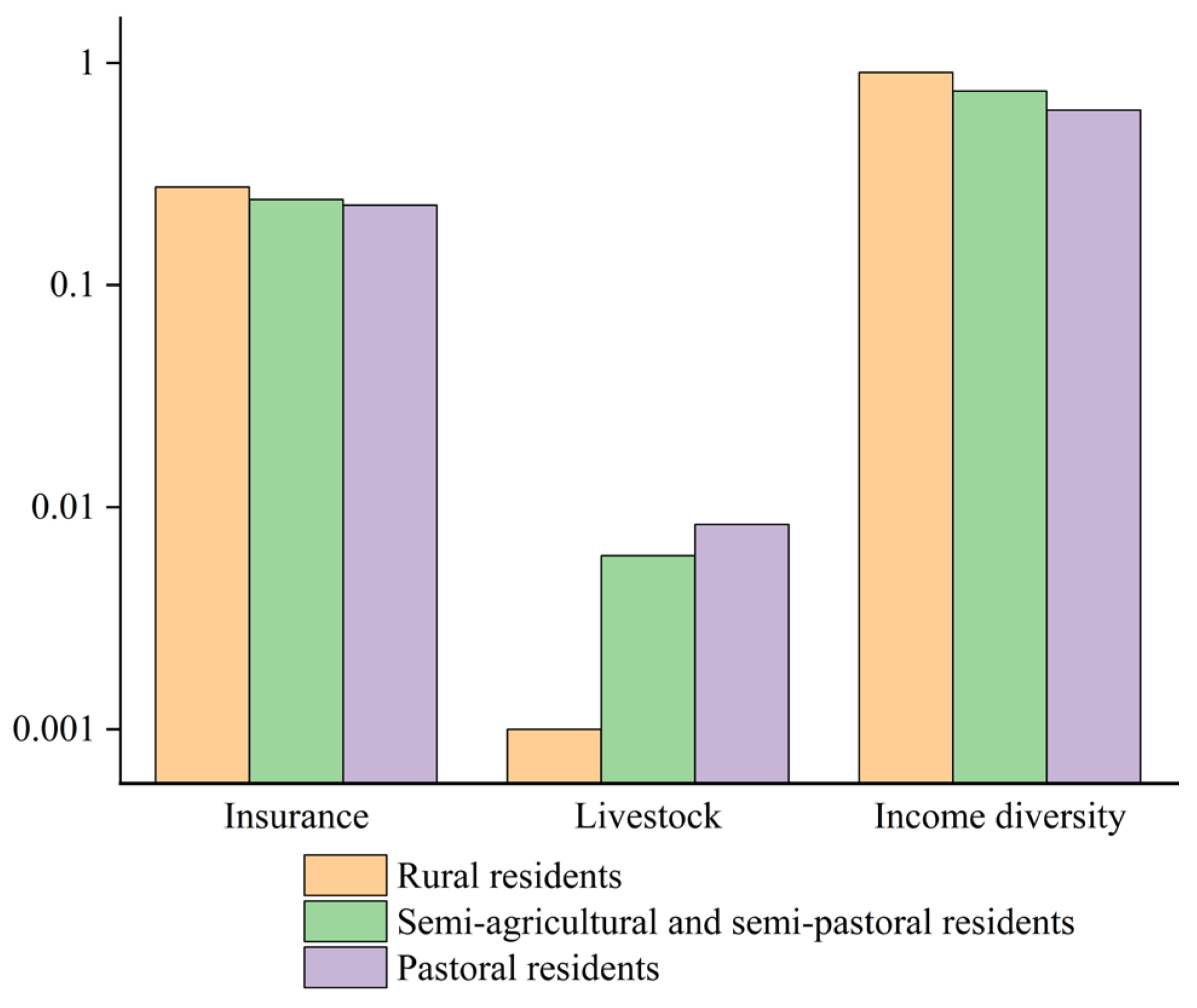
Concerning recovery capacity (0.15), economic income recovery has the highest weighting value (0.760), indicating that income structure diversification and livestock numbers significantly impact post-disaster recovery. Specifically, more diverse income sources and a stronger material foundation are associated with faster economic recovery. Post-disaster compensation and insurance coverage (0.24) serve as supplementary risk transfer mechanisms. However, due to constraints such as limited insurance awareness in pastoral areas and inefficient claims processing, their direct impact on households’ proactive economic recovery is weaker than that of household income structure adjustments.
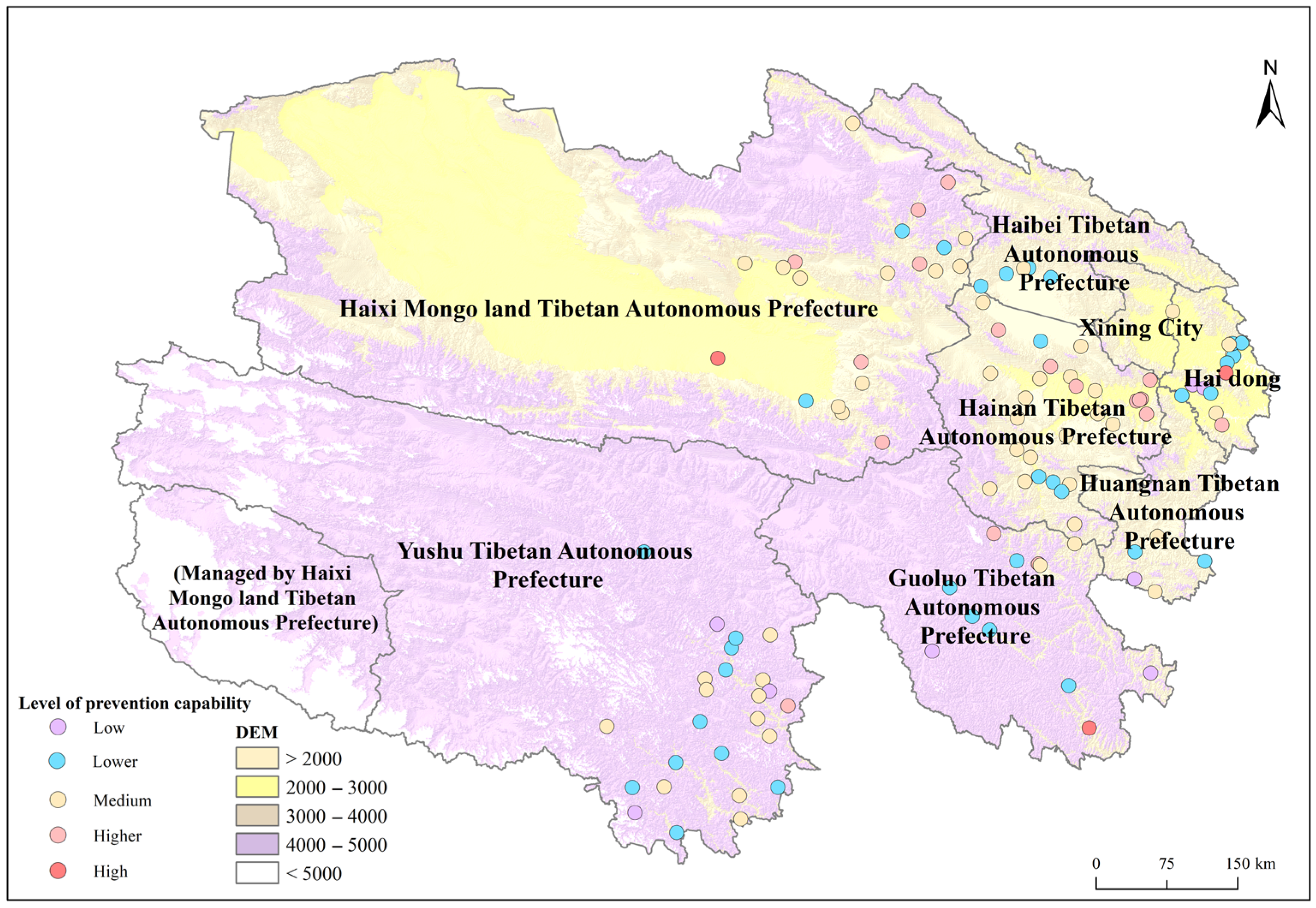
The grassland fire prevention capacity scores, calculated using the proposed evaluation model, range from 0.058 to 0.376. Based on the natural break classification method, these scores were divided into five distinct levels of prevention capacity: low, relatively low, moderate, relatively high, and high. The corresponding score intervals for these categories are as follows: 0.058–0.143, 0.143–0.183, 0.183–0.224, 0.224–0.270, and 0.270–0.376 (Figure 2). According to these classification thresholds, the grassland fire prevention capacity of residents across 111 townships was further categorized into the respective capacity levels, enabling a comparative spatial assessment of prevention capabilities within the study area.

3.1.2. Comparative Analysis of Grassland Fire Prevention Capacities Across Agricultural and Livestock Production Systems

With respect to overall grassland fire prevention capacity, semi-agricultural and semi-pastoral regions exhibit superior performance compared to agricultural regions, which in turn surpass pastoral areas. Semi-agricultural and semi-pastoral areas are commonly situated adjacent to or interspersed within expansive grassland ecosystems. Local livelihoods in these zones depend on a dual economic structure that integrates both crop cultivation and livestock grazing, wherein grasslands constitute a critical resource base for fodder production and pastoral activities. As a result, the protection and stability of grassland environments directly affect livestock survival and the economic resistance of rural households. Owing to the high ecological sensitivity of grassland ecosystems to ignition sources, residents in agricultural areas primarily acquire fire prevention knowledge through institutional channels, including government-led awareness campaigns and educational outreach programs. In contrast, residents of semi-agricultural and semi-pastoral regions typically cultivate fire-related knowledge through intergenerational transmission and sustained practical experience. These communities demonstrate a heightened emphasis on both fire prevention and emergency response, and generally possess a more nuanced and comprehensive understanding of grassland fire behavior, early detection, and mitigation strategies.
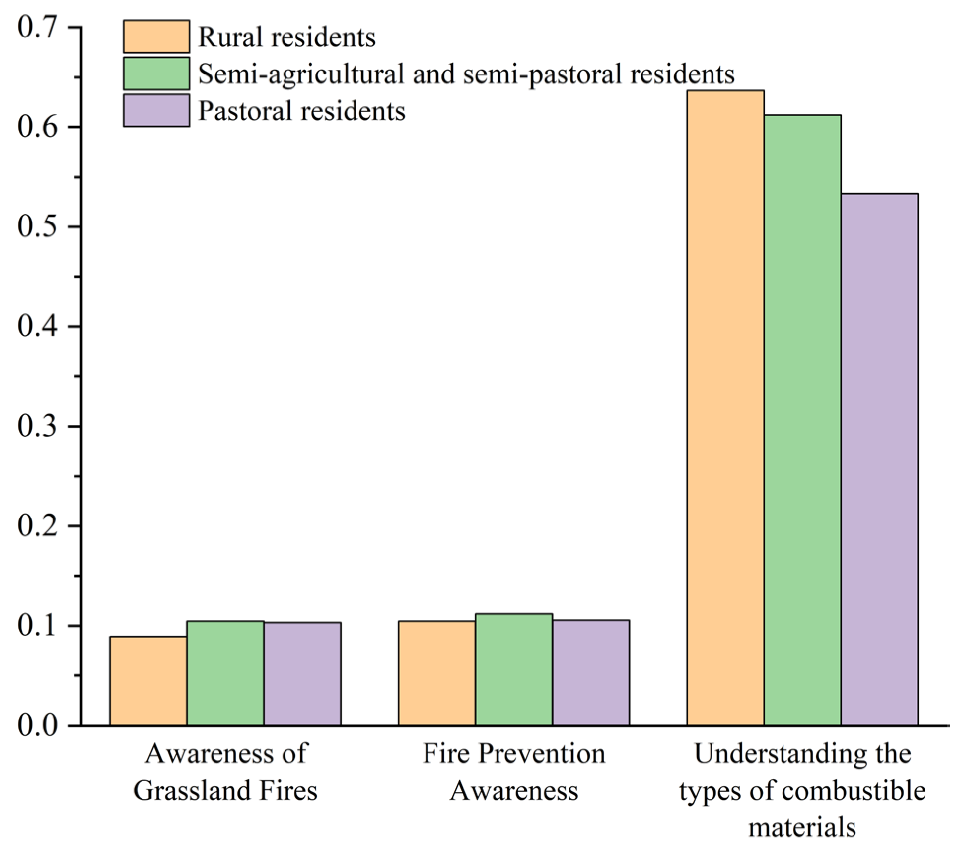
Among the various dimensions of residents’ fire prevention awareness, individuals in agricultural, semi-agricultural/semi-pastoral, and pastoral areas demonstrated relatively high scores in both awareness of fire-prone periods and general fire-related knowledge (Figure 3). This reflects their strong capacity to identify critical phases of grassland fire risk and a broad understanding of fire dynamics. These results suggest that, through the cumulative effects of formal fire prevention education and hands-on experience, residents in grassland regions have developed a relatively mature cognitive framework encompassing fire prevention knowledge and risk perception. This foundation contributes to an enabling environment for the sustained development of comprehensive regional fire prevention strategies. Despite these strengths, environmental risk awareness—particularly concerning the identification of combustible materials associated with grassland fires—remains insufficient across all groups. Pastoral residents, in particular, exhibited the lowest levels of awareness in this dimension. This deficiency appears to correlate with regional disparities in educational attainment. Specifically, the proportions of individuals with a secondary education or higher were 73.25% and 75.50% in agricultural and semi-agricultural/semi-pastoral areas, respectively, whereas the corresponding proportion in pastoral areas was only 54.49%. These disparities reflect uneven access to educational resources and systemic limitations in educational outreach, which hinder residents’ ability to accurately perceive environmental risks and understand technical aspects of combustible materials. As a result, reduced educational attainment may also contribute to lower levels of engagement and motivation in acquiring fire prevention knowledge.
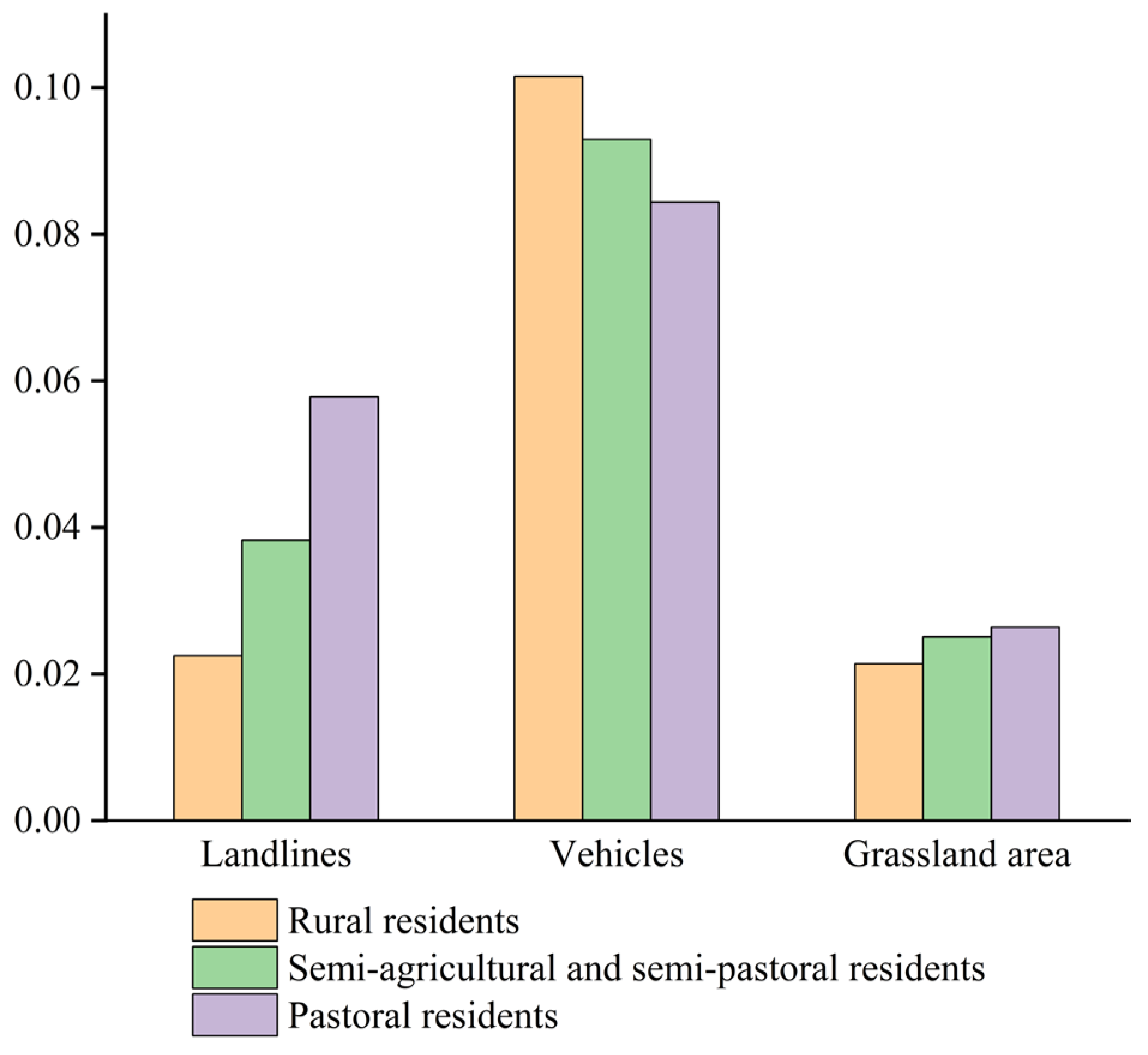
Among the indicators of household material endowment (Figure 4), motor vehicle ownership exhibited relatively high scores, indicating that most households in the study area possess strong transportation capacity and a moderate level of economic capital. This resource is instrumental in facilitating the mobilization of fire prevention resources, population displacement, and rapid emergency response. Compared with pastoral households, those in agricultural and semi-agricultural/semi-pastoral areas demonstrated higher motor vehicle ownership rates, reflecting more developed transportation infrastructure and overall higher levels of material capital. In contrast, pastoral areas scored higher in terms of grassland area and fixed-line telephone penetration. Given the extensive grassland landscapes, residents in these regions place greater emphasis on patrol and surveillance, and actively engage in grassroots fire prevention initiatives. During fire events, livestock and residents can be relocated swiftly to alternative grazing zones, thereby mitigating potential losses. Moreover, the vast and sparsely populated terrain enhances direct lines of communication among herders, villages, and government authorities, enabling more time and coordinated responses to grassland fire emergencies.
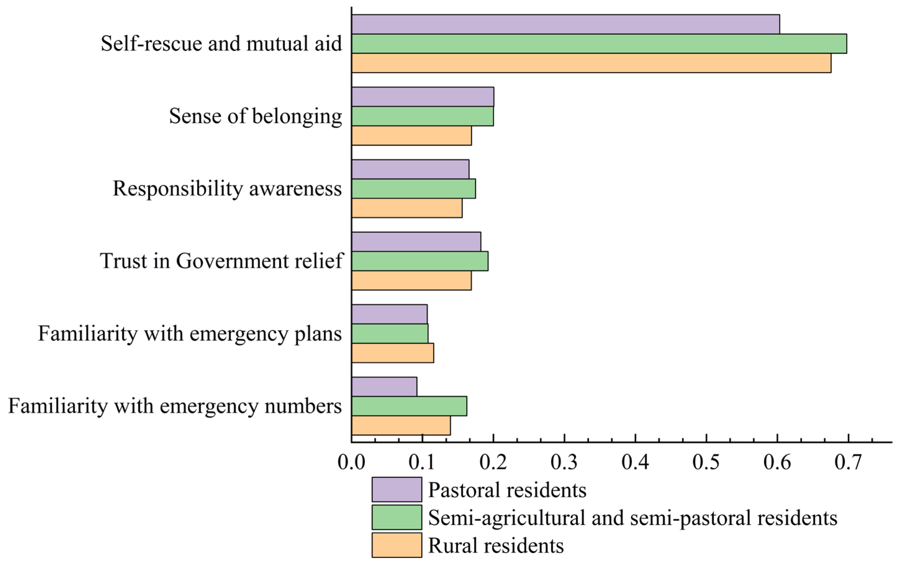
In terms of individual disaster relief capacity (Figure 5), residents of semi-agricultural and semi-pastoral areas achieved the highest scores in familiarity with grassland fire emergency hotlines, significantly outperforming those in both agricultural and pastoral areas. This indicates a higher level of awareness regarding fire reporting procedures and information-gathering capabilities during the early stages of fire events. Regarding familiarity with emergency plans, agricultural area residents scored the highest, marginally ahead of residents in pastoral and semi-agricultural/semi-pastoral areas. This can be attributed to the more frequent organization of emergency drills and public education campaigns in agricultural regions.
The primary information channels also vary across regions. In agricultural areas, 39.53% of residents reported acquiring fire-related knowledge through formal media such as television, WeChat, radio broadcasts, and government briefings. In contrast, 49.10% of pastoral residents relied primarily on informal communication channels, such as conversations with friends and family or passive reception of information. The vast geographical expanse and sparse population distribution in pastoral areas further hinder the efficient dissemination of fire prevention information.
With respect to social cohesion, residents in semi-agricultural and semi-pastoral areas demonstrated the strongest collective cohesion, encompassing both intra-community cohesion and resident–government cooperation. Notably, when asked whether “families should play an important role in disaster prevention and mitigation,” 74.25% of pastoral residents expressed agreement, followed by 68.43% in semi-agricultural/semi-pastoral areas and 54.65% in agricultural areas. This pattern suggests that pastoral and semi-pastoral residents place greater emphasis on collective and familial responsibility in disaster relief, indicating a stronger sense of social responsibility within these communities.
In contrast, residents in agricultural areas exhibited relatively weak cohesion, suggesting that mutual trust and collaboration between the public and local authorities in disaster management remain underdeveloped. Moreover, pastoral production systems are characterized by spatial dispersion, as herders must relocate livestock across wide and remote grazing areas following seasonal cycles. This nomadic pattern reduces the frequency of interpersonal interaction among herders, contributing to weaker community ties and limited social cohesion in pastoral regions.
From the perspective of disaster compensation and economic income recovery (Figure 6), rural residents demonstrated the highest level of insurance participation, with 31.98% of respondents reporting ownership of three or more insurance policies—indicative of relatively high risk awareness. In contrast, only 39.52% of pastoral residents reported having purchased a single type of insurance, highlighting deficiencies in risk management coverage. This disparity is largely attributable to the mobile production practices and spatial dispersion of pastoral households, which complicate insurance access and utilization. Questionnaire responses further revealed a general lack of trust in insurance institutions among pastoral residents, alongside dissatisfaction with delayed claims processing. In comparison, agricultural areas benefit from diversified income sources and exhibit greater economic resistance. Semi-agricultural and semi-pastoral areas, while maintaining moderate levels of livestock holdings and insurance coverage, show strong potential for risk prevention in multi-hazard environments. In contrast, pastoral areas remain highly vulnerable to disasters due to low insurance uptake, a high concentration of economic assets in livestock, and a reliance on single-source incomes. These structural limitations reduce their capacity to absorb shocks and recover economically in the aftermath of fire events or other natural hazards.

3.2. Factors Affecting Residents’ Ability to Prevent Grassland Fires

The Wald test results further indicated that the regression coefficients differed significantly across quantile points. This finding suggests that the mechanisms of action of the variables vary among low-, medium-, and high-capability groups. Residents’ grassland fire prevention capacity in Qinghai Province was selected as the dependent variable, while natural environmental conditions, risk communication, risk perception, and infrastructure and service factors were included as independent variables. A quantile regression model was employed to identify the key influencing factors across different levels of prevention capacity, focusing specifically on the 0.25, 0.50, and 0.75 quantiles (Table 3). To address potential endogeneity concerns and to provide a baseline comparison, ordinary least squares (OLS) regression was also conducted. Prior to modeling, correlation tests and variance inflation factor (VIF) tests were conducted on the explanatory variables. The results indicated that no serious multicollinearity was present. To ensure robustness, additional tests were performed, including repeated estimations at different quantiles and Bootstrap sampling. The results showed that the conclusions of each test were largely consistent with the benchmark regression, indicating that the model demonstrates strong robustness. The overall OLS regression model was significant (F = 20.112, p < 0.001), confirming that the selected variables effectively explain residents’ grassland fire prevention capabilities. In comparison, the quantile regression demonstrated higher goodness-of-fit across different quantiles. The pseudo-R2 values were 0.082 (q = 0.25), 0.092 (q = 0.50), and 0.095 (q = 0.75), all exceeding the OLS R2 of 0.049. Furthermore, the mean absolute error (MAE) of the quantile regression was smaller (0.0478, 0.0395, and 0.0494), underscoring its advantage in fitting accuracy. Due to space limitations, the discussion in this section is restricted to the statistically significant results obtained from the quantile regression analysis.
The influence of annual precipitation (X2) on grassland fire prevention capacity demonstrates substantial heterogeneity. At the 0.25th percentile, annual precipitation exhibits a significantly negative association (p < 0.05), with the most pronounced effect observed among residents possessing low prevention capabilities. However, at the 0.50th and 0.75th percentiles, this influence is statistically insignificant. The effect of aridity (X3) on prevention capacity also varies across percentiles. At the 0.25th percentile, it presents a non-significant negative effect; at the 0.50th percentile, a non-significant positive effect is observed; and at the 0.75th percentile, aridity demonstrates a significant positive effect (p < 0.05). Furthermore, a one-unit increase in aridity leads to a 1.1% improvement in fire prevention capability among high-perception groups, suggesting that environmental dryness has a more substantial facilitative effect on the preparedness of populations already equipped with high prevention capacity.
Panic levels (X6) have a consistently significant positive effect on grassland fire prevention capabilities across the 0.25th, 0.50th, and 0.75th percentiles (p < 0.01), with the magnitude of this effect remaining stable across quantiles. This indicates that panic effectively enhances residents’ disaster awareness and responsive behavior, especially among groups with medium-to-high prevention capacities, where panic is more likely to result in concrete fire prevention actions, thereby substantially improving their preparedness levels.
The effect of road density (X8) on prevention capacity varies by percentile. At the 0.50th and 0.75th percentiles, it exerts a significant positive effect (p < 0.01 and p < 0.05), although the intensity weakens as the percentile increases. This suggests that improved transportation infrastructure strengthens the fire prevention capabilities of resource-equipped and awareness-oriented groups. However, its effect at the 0.25th percentile is not statistically significant, possibly due to persistent obstacles preventing these groups from translating infrastructure advantages into effective prevention actions.
According to the quantile trend, the influence of knowledge acquisition channels (X10) is most evident among high-preparedness groups, with its positive effect intensifying as the quantile increases (p < 0.05). This suggests that access to more diverse and effective fire-related information channels significantly enhances fire prevention capabilities in these populations. Finally, public fire risk communication (X11) demonstrates a significant positive effect on prevention capacity (p < 0.01), indicating that effective public outreach and education efforts play a crucial role in strengthening residents’ disaster preparedness.
Grassland fire prevention capability is primarily driven by effective risk communication. Residents in agricultural regions actively seek fire-related information and benefit from access to multiple communication channels, resulting in significantly enhanced prevention capabilities relative to those in pastoral regions. Furthermore, panic induced by grassland fires serves as a secondary influencing factor; the greater the psychological panic among residents, the higher the likelihood of adopting proactive preventive measures. Populations with higher levels of prevention preparedness express greater concern over climatic aridity. However, substantial gaps remain in residents’ comprehension of climate change, as well as in the capacity of grassroots institutions to establish effective response mechanisms. Therefore, future strategies should prioritize enhancing society-wide fire prevention capabilities through science communication initiatives, meteorological data sharing, emergency preparedness drills, and capacity-building programs for village and township committees. Such efforts are essential to shift from reactive response models to proactive prevention paradigms.

4. Discussion

4.1. Differences in Residents’ Grassland Fire Prevention Capabilities

This study evaluates grassland fire prevention capabilities across various agricultural and pastoral production types in Qinghai Province by developing a comprehensive index system. The analysis reveals significant intergroup differences across four dimensions. Within the constructed evaluation framework, disaster resistance holds the highest weight, primarily due to the critical role of household material endowments in enhancing resistance [61]. This finding suggests that regional disaster mitigation policies should prioritize improvements in household economic conditions and material assets [62,63], without overlooking the need to improve household literacy levels [47]. By contrast, environmental risk perception and household quality endowments carry relatively low weights, indicating that local governments and relevant authorities should intensify efforts to raise awareness of environmental risks and enhance individual-level disaster prevention literacy.
From a production-type perspective, residents in semi-agricultural and semi-pastoral areas exhibit markedly stronger grassland fire prevention capabilities compared to those in purely agricultural or pastoral areas. This can be attributed to more diversified income sources, accumulated practical experience, and higher education levels, which collectively enhance their fire awareness, early disaster identification, and responsive strategies. This advantage derives from their comprehensive knowledge, acquired via intergenerational transmission and cumulative practical experience, underscoring the importance of real-world experience in disaster preparedness. In addition, relatively favorable material conditions in these regions further bolster both prevention and resistance capabilities.
Conversely, pastoral residents tend to have weaker prevention capacities, largely due to factors such as limited education, restricted access to information, and underdeveloped communication infrastructures. This highlights the urgent need to enhance fire prevention education and improve information accessibility in pastoral areas [64]. While these residents demonstrate strong family and collective responsibility awareness, they generally exhibit weak insurance participation and limited economic recovery capacity, indicative of high levels of economic vulnerability [65]. Therefore, it is imperative to promote economic diversification, optimize insurance product design and claims mechanisms, and increase pastoral residents’ engagement in formal risk-sharing mechanisms. Although rural residents generally exhibit strong familiarity with emergency protocols and participate actively in insurance programs, their collective cohesion remains relatively weak. Accordingly, future disaster prevention strategies in rural areas should emphasize strengthening collaboration between residents and local governments, organizing more community-based emergency drills, and cultivating a strong sense of collective participation to enhance overall prevention capacity [66].
Therefore, policy measures should be tailored to the varying capabilities of different regions in order to prevent grassland fires. In pastoral areas, emphasis should be placed on strengthening education [67] and enhancing information dissemination to increase insurance participation. In semi-agricultural and semi-pastoral areas, the advantages of diversified income and higher educational attainment should be leveraged to promote community-based sharing of fire prevention knowledge. In agricultural areas, collective drills and grassroots cooperation should be reinforced to strengthen community cohesion. This study takes Qinghai Province as a case, but the applicability of the constructed evaluation index system to other regions requires further validation. Regional differences in natural conditions, socioeconomic structures, and disaster prevention experience imply that adjustments are necessary when applying the model to other areas. For instance, regions with more abundant grassland resources or a more specialized economic structure may prioritize disaster prevention differently from Qinghai Province’s semi-agricultural and semi-pastoral areas.

4.2. Factors Affecting the Ability to Prevent Grassland Fires

This study developed environmental indicators based on climatic variables, including annual mean temperature, precipitation, and aridity, at the survey sites. Grassland fires are closely linked to climatic conditions and pose substantial natural disaster risks to residents’ livelihoods and daily activities. Disaster-related environmental factors not only constitute objective environmental constraints on residents’ disaster preparedness but also significantly shape their behavioral responses. Nevertheless, some residents continue to adhere to traditional beliefs that their livelihoods are inherently dependent on climatic conditions, regarding grassland fires as natural and uncontrollable phenomena. This perception undermines their initiative and proactive engagement in fire prevention efforts [68].
The findings also indicate that panic intensity plays a statistically significant role in the quantile regression model, whereas variables such as the perceived likelihood of fire occurrence, its impact on production and daily life, and prior disaster experience do not exhibit significant statistical associations. Panic responses are closely associated with risk judgment and behavioral reactions; when panic levels are low, residents tend to respond with passive preventive behaviors [69]. Moreover, levels of social panic are directly influenced by the degree of coordination in governmental disaster prevention efforts and the extent of community participation [70]. In this study, residents with prior experience of grassland fires achieved an average score of 0.199 in disaster prevention capability, compared to 0.195 among those without such experience, indicating comparatively stronger preparedness among the experienced group [71]. However, several studies [72,73,74] have shown that prior disaster experience is not consistently correlated with actual preventive behavior. One possible explanation is that repeated exposure to disaster events can desensitize residents to risks, weakening their awareness and willingness to adopt mitigation strategies. Alternatively, reliance on government trust [75] and community support networks may alleviate perceived risk burdens.
Although “probability” and “perceived severity of impact” are theoretically fundamental components of risk perception, they do not significantly influence grassland fire prevention behaviors in this context. This may be attributable to residents’ development of habitual desensitization or normalization in response to recurrent fire disasters, leading them to underestimate actual risks and delegate responsibility for prevention to governmental authorities. Survey results further reveal that residents in pastoral and semi-pastoral regions exhibit stronger agreement with the notion that fire prevention is primarily the government’s responsibility—75.45% and 76.91%, respectively—compared to 69.77% in agricultural regions, where the belief is slightly less prevalent.
Infrastructure and grassroots services constitute the foundational pillars of disaster prevention capacity enhancement [76]. Among these, road density serves as a proxy for transportation capacity—greater road density indicates a more advanced transportation network, which in turn facilitates faster emergency responses, optimizes material allocation efficiency, and enhances routine patrol and fire prevention management efforts. However, the analysis finds no statistically significant association between the administrative capacities of residents’ committees and their disaster preparedness levels. This may be attributed to the fact that such committees are often not institutionally mandated with fire prevention duties, or they only engage in auxiliary tasks such as awareness campaigns, thereby limiting their ability to assume a substantive role in fire mitigation. Moreover, residents’ committees are primarily located in residential zones rather than directly within grassland regions, leading to spatial mismatches that hinder comprehensive fire management. In addition, committees frequently lack systematic coordination mechanisms with firefighting and forestry departments, typically occupying the terminal position within the fire warning and reporting system. This institutional positioning results in delayed responses and limited capacity for early intervention. Risk governance by government and grassroots institutions is a critical dimension of modern public administration [77], acting as both a guarantor of risk mitigation and a catalyst for social participation [78]. The government’s decision-making power manifests through resource allocation, funding priorities, and research support, directly shaping the structure and efficiency of public disaster relief systems [79]. Prioritizing grassroots emergency management is therefore essential for enhancing China’s overall disaster governance framework.
Furthermore, risk communication demonstrates a statistically significant correlation with fire prevention capacity. The availability and diversity of information sources directly affect the effectiveness of public risk communication, thereby strengthening residents’ disaster awareness. Multiple dissemination pathways contribute to heightened crisis sensitivity regarding grassland fires, while timely and reliable information transmission improves cognitive accuracy, enabling appropriate and efficient behavioral responses that mitigate or prevent fire-related losses [80,81].
Therefore, in the ongoing efforts to prevent and control grassland fires, it is imperative to continuously enhance public risk awareness through the establishment of diversified and efficient information dissemination systems and the reinforcement of risk communication mechanisms. These efforts will form the foundation for improving residents’ knowledge of grassland fire risks and their capacity to respond effectively to fire-related threats. Simultaneously, preventive strategies must align with evolving climate change dynamics, adopt dynamic monitoring of emerging fire risk characteristics, and promote a more scientific and forward-looking approach to fire management. It is also critical to recognize the inherent subjectivity and limitations in residents’ risk perception, with particular emphasis on guiding the public toward proactive prevention awareness and strengthening behavioral response capabilities. Such efforts will facilitate a transition from passive risk acceptance to active community participation, gradually establishing a comprehensive framework for grassland fire prevention and control characterized by broad-based public engagement and integrated, multi-level governance.

5. Conclusions

The primary conclusions are as follows:
(1) Disaster resistance capacity (0.49) was the most influential component of grassland fire prevention in Qinghai Province, with economic foundations and individual relief abilities playing key roles. Despite high awareness levels, limited collaboration and uneven prevention capacity highlight the need for locally adapted policy interventions.
(2) Significant differences in prevention capacity exist across production systems, with semi-agricultural/semi-pastoral residents outperforming pastoral residents. Disparities stem from variations in awareness, education, resources, information access, and insurance coverage, indicating the need for region-specific strategies to improve resistance in vulnerable pastoral areas.
(3) The ability to prevent grassland fires is significantly influenced by risk communication, panic, and climate dryness. The more information people have, the stronger their ability to prevent fires. Effective and diverse risk communication is a prerequisite for improving residents’ ability to prevent fires. The degree of panic about grassland fires and road infrastructure are important factors, but residents’ perceptions of climate change, risk perception, and grassroots organizations’ role in building response mechanisms do not have a significant impact. Therefore, in future grassland fire disaster prevention and mitigation efforts, it is essential to strengthen risk communication, improve infrastructure, monitor environmental changes and the spatiotemporal patterns of grassland fires, enhance residents’ understanding of climate dynamics, reinforce the emergency relief capabilities of grassroots organizations, stimulate public participation awareness, and promote the formation of a multi-stakeholder, scientifically informed prevention and control framework.
This study has several limitations. Some indicators rely on self-reported data from residents, which may introduce subjective bias. In addition, the lack of high-resolution and detailed data constrains further expansion and validation of the results. The indicator system and methodological choices may overlook socio-cultural factors that are difficult to quantify, and the robustness of the conclusions requires validation using alternative methods. Moreover, the model did not fully account for dynamic variables such as long-term climate change trends and the effects of policy implementation.
Future research could proceed in three directions. First, remote sensing and GIS technologies should be integrated to obtain higher-resolution environmental and disaster data, thereby improving the accuracy and reliability of fire risk assessments. Second, the indicator system and model proposed in this study should be applied to different regions and ecosystems to validate their cross-regional applicability and practical value. Finally, incorporating the temporal evolution of fire risk and climate dynamics would allow examination of prevention capability trajectories under long-term climate change and policy implementation.
Nevertheless, the methods and conclusions of this study provide a valuable reference for other grassland regions with similar ecological and social contexts, offering insights for international grassland fire prevention research. In the context of global climate change, the frequency and intensity of grassland fires continue to increase. This study highlights differentiated assessments and micro-level analyses of residents’ prevention capabilities. It thus provides a potential reference path for ecologically vulnerable regions worldwide, including alpine grasslands and arid pastures. The findings not only contribute to disaster prevention and mitigation practices on the Qinghai–Tibet Plateau but also carry significant implications for advancing international disaster risk governance in the context of climate change.

Author Contributions

Writing—original draft preparation, W.X.; conception and writing—review and editing, Q.Z. and F.L.; writing—review and editing, methodology, W.M. and L.L. All authors have read and agreed to the published version of the manuscript.

Funding

This study was supported by the Qinghai Provincial Key R&D and Transformation Program for the Transformation of Scientific and Technological Achievements Special Project, China, under Grant (number 2023-SF-109).

Institutional Review Board Statement

Not applicable.

Informed Consent Statement

Not applicable.

Data Availability Statement

The data presented in this study are available upon request from the corresponding author. The data are not publicly available due to privacy.

Acknowledgments

We are very grateful to the academic editors and reviewers for their valuable suggestions, as well as to the subject students for their contributions to data collection.

Conflicts of Interest

The authors declare no conflicts of interest.

References

  1. Yu, B.; Lv, C. Assessment of ecological vulnerability on the Tibetan Plateau. Geogr. Res. 2011, 30, 2289–2295. [Google Scholar]
  2. Mofokeng, O.D.; Adelabu, S.A.; Jackson, C.M. An Integrated Grassland Fire-Danger-Assessment System for a Mountainous National Park Using Geospatial Modelling Techniques. Fire 2024, 7, 61. [Google Scholar] [CrossRef]
  3. Ding, J.; Zhong, H.; Xu, L.; Yu, J. Comparison of Township Disaster Reduction Capacity Assessment Results Based on Three Methods: A Case Study for 18 Townships in a Certain Distnict of a City. J. Catastrophol. 2024, 39, 80–88. [Google Scholar]
  4. Zheng, Y. Considerations on social defense against meteorological disasters and the government’s enhancement of disaster management capabilities. Public Commun. Sci. Technol. 2019, 11, 166–167. [Google Scholar]
  5. Hu, Y.; Zeng, G. Disaster Mitigation and Prevention by Paying Attention to Global Climate Change. Environ. Sci. Surv. 2011, 30, 15–18. [Google Scholar]
  6. Qin, L.; Zhang, Q.; Guo, J. The Practice and Experience of Meteorological Disaster Prevention and Mitigation in Other Countries. China Popul. Resour. Environ. 2014, 24, 349–354. [Google Scholar]
  7. Shen, L. Canadian Disaster Prevention and Mitigation Addressing Climate Change. Glob. Sci. Technol. Econ. Outlook 2009, 24, 5–12. [Google Scholar]
  8. Ding, Y. Evaluation of Comprehensive Disaster Prevention Capability and Study on Prevention Model of Tibetan Plateau. Master’s Thesis, Qinghai Normal University, Xining, China, 2024. [Google Scholar]
  9. Zhou, J. The coast of Tianjin was hit by storm surges, and marine fisheries suffered heavy losses. China Fish. 2003, 46, 36. [Google Scholar]
  10. Zhao, X.; Gao, L. Research on fishery loss caused by storm surge disaster. Chin. Fish. Econ. 2015, 33, 89–94. [Google Scholar]
  11. You, Z.; Jiang, Q. On land use disaster prevention planning based on the storm-hitting risk regionalization in Jiangsu coastal line areas. J. Saf. Environ. 2013, 13, 254–258. [Google Scholar]
  12. Guo, T.; Xu, X.; Wang, Z. Typhoon Disasters in China’s Coastal Areas and Risk Assessment of its Impact on Land Use Since 1990. J. Catastrophol. 2014, 29, 193–198. [Google Scholar]
  13. Song, C.; Liu, C.; Ye, H. Assessment of City’s ability in Debris Flow Disaster Prevention and Reduction. South-North Water Transf. Water Sci. Technol. 2007, 5, 117–120. [Google Scholar]
  14. Guo, T.; Cao, Q.; Yang, L. Mining Risk Factors of Storm Surge Disasters Based on Disaster Prevention and Mitigation Policy Texts. Trop. Geogr. 2025, 45, 691–703. [Google Scholar]
  15. Bo, M.; Dai, D.; Liao, W. Resilient Response in Coastal Urban Planning Based on Ecosystem-based Disaster Risk Reduction: A Case Study of Compound Rainstorm and Heatwave Extreme Risks in Shanghai. Landsc. Archit. 2025, 33, 1–25. [Google Scholar]
  16. Hasan, Z.; Mahidin, M.; Irwansyah, M. Spatial planning-based disaster mitigation model in coastal settlement zone of Banda Aceh City. IOP Conf. Ser. 2025, 1477, 012023. [Google Scholar] [CrossRef]
  17. Li, M.; Yuji, H.; Wakako, T.; Yuna, N.; Nagasawa, M. A Fire Prevention Measure for Disaster Prevention Planning Based on Resident Conditions and Community Characteristics in Preserved Historic Districts/Village in Japan. Int. J. Archit. Herit. 2025, 19, 194–215. [Google Scholar] [CrossRef]
  18. Wang, Z.; Zhang, F.; Liu, S.; Xu, D. The Impacts of Government Training on Farmers’ Willingness and Behavior of Disaster Prevention and Mitigation in Flood Risk Areas. J. Catastrophol. 2025, 40, 36–41. [Google Scholar]
  19. Yan, B.; Weng, S.; Tan, W. Preliminary study on planning strategies of green space system for disaster prevention of Shapingba downtown with dense work-units in Chongqing. J. Nat. Disasters 2012, 21, 136–143. [Google Scholar]
  20. Chen, J.; Wen, X. Discussion on the Construction of Disaster Prevention Green Space in High-Density Urban—A Case Study of Wuhou District in Chengdu City. J. Huaihua Univ. 2012, 31, 88–92. [Google Scholar]
  21. Wang, C. Analysis of Urban Center Park’s Space Reconstruction for the Function on Disaster Prevention and Refuge-Taking Wuhan Zhongshan Park as an Example. Master’s Thesis, Huazhong Agricultural University, Wuhan, China, 2010. [Google Scholar]
  22. Berke, P.; Newman, G.; Lee, J.; Combs, T.; Kolosna, C.; Salvesen, D. Evaluation of Networks of Plans and Vulnerability to Hazards and Climate Change: A Resilience Scorecard. J. Am. Plan. Assoc. 2015, 81, 287–302. [Google Scholar] [CrossRef]
  23. O’Sullivan, T.L.; Kuziemsky, C.E.; Toal-Sullivan, D.; Corneil, W. Unraveling the complexities of disaster management: A framework for critical social infrastructure to promote population health and resilience. Soc. Sci. Med. 2013, 93, 238–246. [Google Scholar] [CrossRef]
  24. Zorn, C.R.; Shamseldin, A.Y. Post-disaster infrastructure restoration: A comparison of events for future planning. Int. J. Disaster Risk Reduct. 2015, 13, 158–166. [Google Scholar] [CrossRef]
  25. Bruneau, M.; Chang, S.E.; Eguchi, R.T.; Lee, G.C.; O’Rourke, T.D.; Reinhorn, A.M.; Shinozuka, M.; Tierney, K.; Wallace, W.A.; Winterfeldt, D.V. A Framework to Quantitatively Assess and Enhance the Seismic Resilience of Communities. Earthq. Spectra 2003, 19, 733–752. [Google Scholar] [CrossRef]
  26. Joerin, J.; Shaw, R.; Takeuchi, Y.; Krishnamurthy, R. The adoption of a climate disaster resilience index in Chennai, India. Disasters 2014, 38, 540–561. [Google Scholar] [CrossRef] [PubMed]
  27. Razafindrabe, B.; Parvin, G.; Surjan, A.; Takeuchi, Y.; Shaw, R. Climate Disaster Resilience: Focus on Coastal Urban Cities in Asia. Asian J. Environ. Disaster Manag. 2009, 1. [Google Scholar] [CrossRef]
  28. Cutter, S.L.; Burton, C.G.; Emrich, C.T. Disaster Resilience Indicators for Benchmarking Baseline Conditions. J. Homel. Secur. Emerg. Manag. 2010, 7, 1–22. [Google Scholar] [CrossRef]
  29. Li, Y.; Zhai, G. China’s Urban Disaster Resilience Evaluation And Promotion. Planners 2017, 33, 5–11. [Google Scholar]
  30. Liu, M. Urban Resilience Evaluation from the Perspective of Disaster Prevention. Master’s Thesis, North China University of Science and Technology, Tangshan, China, 2022. [Google Scholar]
  31. Sun, Y.; Zhang, L.; Yao, S. Evaluating resilience of prefecture cities in the Yangtze River delta region from a socio-ecological perspective. China Popul. Resour. Environ. 2017, 27, 151–158. [Google Scholar]
  32. Xu, Z.; Tian, J.; Zhang, J. Urban resilience evaluation system and optimization strategy from perspective of disaster prevention. China Saf. Sci. J. 2019, 29, 1–7. [Google Scholar]
  33. Cui, X.; Zhang, X.; Zhang, J. Theme vein and frontier trend of research on disaster resilience at home and abroad. J. Nat. Disasters 2023, 32, 1–12. [Google Scholar]
  34. Jeong, S.; Yoon, D.K. Examining Vulnerability Factors to Natural Disasters with a Spatial Autoregressive Model: The Case of South Korea. Sustainability 2018, 10, 1651. [Google Scholar] [CrossRef]
  35. Shiozaki, Y.; Nagamatsu, S.; Sato, K.; Bhattacharya, Y. A systematic literature review of empirical validation of disaster resilience indicators. Int. J. Disaster Risk Reduct. 2024, 111, 104681. [Google Scholar] [CrossRef]
  36. Mızrak, S.; Çam, H. Determining the factors affecting the disaster resilience of countries by geographical weighted regression. Int. J. Disaster Risk Reduct. 2022, 81, 103311. [Google Scholar] [CrossRef]
  37. Atsalakis, G.S.; Bouri, E.; Pasiouras, F. Natural disasters and economic growth: A quantile on quantile approach. Ann. Oper. Res. 2021, 306, 83–109. [Google Scholar] [CrossRef]
  38. Bernoussi, A.E.; Arrouchi, M.E. A simulation study comparing statistical approaches for estimating extreme quantile regression with an application to forecasting of fire risk. arXiv 2025, arXiv:2506.23161. [Google Scholar] [CrossRef]
  39. Beyene, M.T.; Leibowitz, S.G.; Pennino, M.J. Parsing weather variability and wildfire effects on the post-fire changes in daily stream flows: A quantile-based statistical approach and its application. Water Resour. Res. 2021, 57, e2020WR028029. [Google Scholar] [CrossRef]
  40. Deng, Y.; Hou, G.; Cai, P. A Brief History of Research on Qinghai Grassland. Qinghai Prata. 2024, 33, 23–29. [Google Scholar]
  41. Huang, Y.; Pan, Y.; Xia, X.; Zhou, Q.; Chen, Q.; Zhang, S. Validating MCD64A1 and FireCCI51 burned area mapping in the Qinghai-Tibetan Plateau. Geocarto Int. 2023, 38, 2285345. [Google Scholar] [CrossRef]
  42. Huang, Y.; Xia, X.; Zhou, Q.; Pan, Y.; Chen, Y.; Li, H. Spatial and Temporal Patterns and Causes of Grassland Fires in Qinghai Province. Prog. Geogr. 2023, 42, 1973–1983. [Google Scholar] [CrossRef]
  43. Xu, Y.; Qian, Y.; Da, H.; Li, B.; Guan, Q. Forest and Grassland Fire Risk Prediction and Early Warning Service in Qinghai Province. Adv. Meteorol. Sci. Technol. 2023, 13, 107–110. [Google Scholar]
  44. Shen, X. Adaptation Strategies and Cognition of Climate Changes and Disasters of the Farmers and Herdsmen on the Qinghai-Tibetan Plateau. J. Yunnan Minzu Univ. 2013, 30, 15–19. [Google Scholar]
  45. Zhou, R. The Problems of Education in Tibet and the Countermeasures. J. Xizang Minzu Univ. 2010, 31, 19–23+33+121. [Google Scholar]
  46. Carney, D. Sustainable Livelihoods Approaches: Progress and Possibilities for Change. 2003; 64. [Google Scholar]
  47. Cassidy, L.; Barnes, G. Understanding Household Connectivity and Resilience in Marginal Rural Communities through Social Network Analysis in the Village of Habu, Botswana. Ecol. Soc. 2012, 17, 11. [Google Scholar] [CrossRef]
  48. Cutter, S.L. The landscape of disaster resilience indicators in the USA. Nat. Hazards 2016, 80, 741–758. [Google Scholar] [CrossRef]
  49. Hegney, D.; Ross, H.; Baker, P.; Rogersclark, C.; King, C.; Buikstra, E.; Watsonluke, A.; Mclachlan, K.; Stallard, L. Building Resilience in Rural Communities: Toolkit; The University of Queensland; University of Southern Queensland: Toowoomba, QLD, Australia, 2008. [Google Scholar]
  50. Zhang, X. Research on the Cohesion Promotion of Village Party Organizations Under the Background of Rural Revitalization—From the Perspective of Organization Al Management. Master’s Thesis, Hebei University of Economics and Business, Shijiazhuang, China, 2020. [Google Scholar]
  51. Kulig, J.; Edge, D.; Joyce, B. Understanding Community Resiliency in Rural Communities through Multimethod Research. J. Rural. Community Dev. 2008, 3, 77–94. [Google Scholar]
  52. Schwarz, A.-M.; Béné, C.; Bennett, G.; Boso, D.; Hilly, Z.; Paul, C.; Posala, R.; Sibiti, S.; Andrew, N. Vulnerability and resilience of remote rural communities to shocks and global changes: Empirical analysis from Solomon Islands. Glob. Environ. Change 2011, 21, 1128–1140. [Google Scholar] [CrossRef]
  53. Guvele, C.A. Gains from crop diversification in the Sudan Gezira scheme. Agric. Syst. 2001, 70, 319–333. [Google Scholar] [CrossRef]
  54. Cao, X.; Lei, Y.; Gong, Y.; Zhang, S.; Luo, X. Study on health assessment method of shearer based on combination weighting method. Coal Sci. Technol. 2020, 48, 135–141. [Google Scholar]
  55. Mu, X.; Guo, X.; Ming, Q.; Hu, C. Dynamic evolution characteristics and driving factors of tourism ecological security in the Yellow River Basin. Acta Geogr. Sin. 2022, 77, 714–735. [Google Scholar]
  56. Chou, H.; Su, L.; Zhang, Y.; Tang, J. Risk Preference, Risk Perception and Farmers’ Adoption of Conservation Tillage. Chin. Rural Econ. 2020, 36, 59–79. [Google Scholar]
  57. Luo, X.; Li, H.; Huang, T.; Rose, T. A field experiment of workers’ responses to proximity warnings of static safety hazards on construction sites. Saf. Sci. 2016, 84, 216–224. [Google Scholar] [CrossRef]
  58. Zhang, Y.; Zhao, B.; Liu, H. Study on accident risk perception bias based on emotion analysis. China Saf. Sci. J. 2022, 32, 16–22. [Google Scholar]
  59. Guo, G.; Li, S.; Nan, L. Social learning, social network and pesticide reduction-Empirical evidence from micro data of farmers. J. Arid Land Resour. Environ. 2020, 34, 39–45. [Google Scholar]
  60. Li, L.; Shen, Q. The Evaluation of Storm Surge Disaster Prevention and Mitigation Capability: Case of Coastal Cities in Shandong Province. Chin. Fish. Econ. 2011, 29, 98–106. [Google Scholar]
  61. Khatibi, S.A.; Golkarian, A.; Mosaedi, A.; Sojasi Qeidari, H. Assessment of Resilience to Drought of Rural Communities in Iran. J. Soc. Serv. Res. 2019, 45, 151–165. [Google Scholar] [CrossRef]
  62. Cheng, H.; Chen, C.; He, Y. Influence of Herdsman Household Asset Endowment on Their Livelihood Risk—Based on Qilian Mountain National Park Survey. Acta Agrestia Sin. 2021, 29, 2817–2826. [Google Scholar]
  63. Li, M.; Pan, X. Research on the impact of multi-subject participation in farmers’ disaster risk management mechanism from the perspective of evolutionary resilience: A case study of Y city. J. Agric. Catastrophol. 2024, 14, 313–315. [Google Scholar]
  64. Hasibuan, A.M.; Gregg, D.; Stringer, R. Accounting for diverse risk attitudes in measures of risk perceptions: A case study of climate change risk for small-scale citrus farmers in Indonesia. Land Use Policy 2020, 95, 104252. [Google Scholar] [CrossRef]
  65. Zhang, H.; Bao, W. Agricultural Meteorological Disasters Insurance and Capacity Building of Disaster Prevention and Mitigation. Res. Agric. Mod. 2012, 33, 166–169+248. [Google Scholar]
  66. Magis, K. Community Resilience: An Indicator of Social Sustainability. Soc. Nat. Resour. 2010, 23, 401–416. [Google Scholar] [CrossRef]
  67. Shi, P. Establishing national integrated disaster reduction strategy and improving catastrophe risk governance capacity. J. Nat. Disasters 2008, 17, 1–8. [Google Scholar]
  68. Zhang, X.; Dong, J.; Yang, L. Research on the path of improving agricultural meteorological disaster prevention and mitigation capabilities. Mod. Agric. 2025, 47, 2–4. [Google Scholar]
  69. Tong, D. Behavioral Typing and Judicial Judgement on the Criminal of Using Dangerous Method to Endanger Public Security. Jianghan Trib. 2022, 65, 128–136. [Google Scholar]
  70. Yu, X.; Cao, J.; Wang, X.; Cai, M. System-dynamics-based Emergency Strategy Analysis for Typhoon Disaster. Manag. Rev. 2018, 30, 222–230. [Google Scholar]
  71. Wang, C.; Yin, J. Analysis of the Flood Risk Perception and its Influence Factors of Shanghai Residents. J. Catastrophol. 2022, 37, 149–154. [Google Scholar]
  72. Huang, B. Study on Public Perception of Urban River Flood Risk. Master’s Thesis, Lanzhou University, Lanzhou, China, 2023. [Google Scholar]
  73. Tian, L.; Tu, J. Earthquake Risk Perception and Its Influencing Factors in Rural China: A Case Study on Survey Data in Chuxiong of Yunnan Province. Insur. Stud. 2014, 35, 59–69. [Google Scholar]
  74. Xu, Y.; Wei, J.; Han, Y.; Zhao, Y. Does Disaster Severity Have a Long-Term Effect on Survivors’ Disaster Preparedness? A Survey a Decade after the 2008 Wenchuan Earthquake in China. Disaster Med. Public Health Prep. 2024, 18, e106. [Google Scholar] [CrossRef]
  75. Han, Z.; Wu, G. Why do people not prepare for disasters? A national survey from China. Npj Nat. Hazards 2024, 1, 1. [Google Scholar] [CrossRef]
  76. Sen, M.K.; Dutta, S. A Bayesian Network Modeling Approach for Time-Varying Flood Resilience Assessment of Housing Infrastructure System. Nat. Hazards Rev. 2022, 23, 04022006. [Google Scholar] [CrossRef]
  77. Tang, J. On the Government Risk Management—Based on the Review of the Government Risk Management Practice at Home and Abroad. Chin. Public Adm. 2015, 31, 6–11. [Google Scholar]
  78. Ulnicane, I.; Knight, W.; Leach, T.; Stahl, B.C.; Wanjiku, W.-G. Framing governance for a contested emerging technology: Insights from AI policy. Policy Soc. 2021, 40, 158–177. [Google Scholar] [CrossRef]
  79. Yan, Y.; Xu, C. Public Perceptions of Technological Risk and Government Role Expectation—An empirical study based on “Science, Technology and Society Barometer Survey”. Sci. Soc. 2024, 14, 134–155. [Google Scholar]
  80. Adger, W.N.; Vincent, K. Uncertainty in adaptive capacity. C. R. Geosci. 2005, 337, 399–410. [Google Scholar] [CrossRef]
  81. Kuruppu, N. Adapting water resources to climate change in Kiribati: The importance of cultural values and meanings. Environ. Sci. Policy 2009, 12, 799–809. [Google Scholar] [CrossRef]
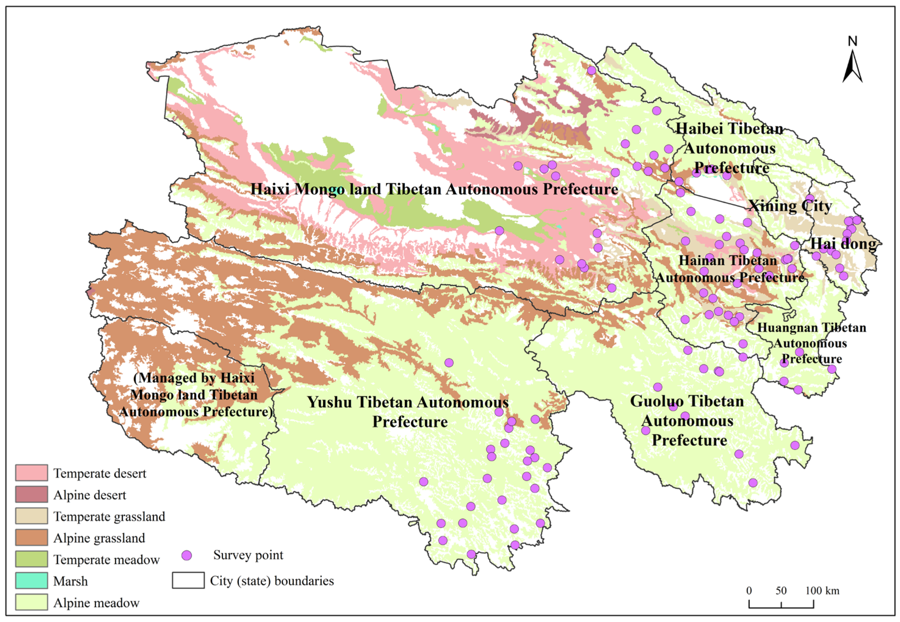
Figure 1. Overview of the research area.
Earth 06 00101 g001
Figure 2. Township grassland fire prevention capability rating.
Earth 06 00101 g002
Figure 3. Grassland fire awareness scores by agricultural production type.
Earth 06 00101 g003
Figure 4. Material endowment scores of resident households engaged in agricultural and livestock production.
Earth 06 00101 g004
Figure 5. Disaster relief cohesion by production type.
Earth 06 00101 g005
Figure 6. Resistance scores by agricultural and livestock production type.
Earth 06 00101 g006
Table 1. Weighting of evaluation indicators for residents’ grassland fire prevention capabilities.
Capability DimensionWeightingPrimary IndicatorWeightingSecondary IndicatorIndicator DescriptionWeighting
Disaster prevention capacity0.15Residents’ fire safety awareness level0.63Awareness of Grassland FiresOverall understanding of grassland fire knowledge0.37
Fire source recognitionUnderstanding of the types of sources of grassland fires0.22
Hazard recognitionUnderstanding the harmful effects of grassland fires0.07
Fire prevention intentionsWillingness to voluntarily learn grassland fire prevention methods0.07
Fire Prevention AwarenessFamiliarity with the grassland fire prevention period0.27
Grassland Fire Prevention Campaign0.21Frequency of information receptionFrequency of receiving information on grassland fire changes and safety measures0.45
ProactivityProactive search and monitoring of fire-related information0.55
Environmental risk awareness0.03Understanding the types of combustible materialsWhat are the combustible materials that contribute to grassland fires?1.00
Fire protection infrastructure completeness0.13Physical facility perceptionAwareness of measures such as fire source isolation and patrol inspections1.00
Disaster resistance0.49Family quality endowment0.09Dependency ratioThe proportion of the total household population aged under 14 and over 64 reflects the vulnerability of the household population.0.69
Proportion of womenThe proportion of women in the total population of households, and the physiological vulnerability of women compared to men.0.11
Level of educationIndicates the level of disaster information reception and judgment capabilities.0.20
Family human capital0.25Proportion of labor force in the householdThe proportion of the working-age population in the total household population0.04
Proportion of village cadres in the villageThe proportion of household members who work as village officials compared to the total household population, and the fact that village officials are more familiar with the village’s disaster prevention and relief facilities than ordinary villagers.0.96
Family material endowment0.66Number of landlinesThe number of telephones owned by households as a percentage of the total household population0.04
Number of vehiclesThe proportion of private cars owned relative to the total number of people in a household0.37
Grassland areaThe proportion of grassland area owned by households relative to the total population of households0.59
Disaster relief capacity0.21Individual disaster relief capacity0.72Familiarity with grassland fire emergency telephone numbersFamiliarity with grassland fire emergency telephone numbers0.45
Alarm reporting capabilityFamiliarity with grassland fire alarm procedures0.05
Correct self-rescue judgmentFamiliarity with correct self-rescue behaviors0.05
Familiarity with emergency plansFamiliarity with emergency plans for the local area0.24
The necessity of preparing emergency suppliesThe necessity of self-funded emergency supplies0.13
Grassland fire emergency response speedWhen faced with a fire, the speed and proactiveness of your response actions are crucial.0.08
Individual-government cohesion0.22Government relief to trustIndividuals’ approval of the government’s relief to grassland fires0.33
Level of understanding of responsibilityUnderstanding of the government’s responsibility for fire safety management0.29
Sense of belongingIndividual responsibility for fire prevention0.38
Cohesion between individuals0.06Neighborhood self-rescue and mutual aidNeighborhood cooperation in responding to fires and mutual rescue tendencies1.00
restorative ability0.15Post-disaster compensation security level0.24Insurance quantityNumber of individuals purchasing insurance1.00
Economic recovery0.76Livestock numbersOne source of household income0.94
Diversification of incomeThe smaller the proportion of livestock income in total income, the greater the diversity of income.0.06
Table 2. Meaning and description of influencing factors.
DimensionIndependent VariableVariable Interpretation and AssignmentMeanStandard Deviation
Natural environmentannual average temperature (X1)Average annual local temperature (°C)−0.6514.141
annual precipitation (X2)Mean annual precipitation in the study area (mm)421.421103.745
Dryness (X3)ArcGIS extraction of dryness of survey points2.3141.094
Risk perceptionPossibility of grassland fires (X4)1 = Strongly disagree; 5 = Strongly agree2.1171.219
Impact on production and daily life (X5)1 = Strongly disagree; 5 = Strongly agree2.8871.411
Level of panic (X6)1 = Strongly disagree; 5 = Strongly agree3.3961.386
Number of grassland fires experienced (X7)The variable was coded on a 5-point ordinal scale: 1 = No experience; 2 = 1–2 times; 3 = 3–4 times; 4 = 5–6 times; 5 = 7 times or more1.2290.512
Infrastructure and ServicesRoad density (X8)The ratio of domestic highway mileage to the registered population7.2535.721
Community committee management capabilities (X9)Percentage of people receiving social support from neighborhood committees per 10,000 people11.45210.339
Risk communicationChannels for acquiring knowledge (X10)Number of channels for obtaining fire-related knowledge1.6530.814
Public communication on fire safety risks (X11)Public understanding and awareness of the causes of grassland fires2.1301.148
Table 3. Results of the quantile regression model test.
DimensionIndependent VariableOrdinary Least Squares MethodQuantile Regression
0.250.500.75
Natural environmentannual average temperature (X1)−0.016 (−0.525)−0.001 (−0.082)0.000 (−0.172)−0.001 (−1.303)
annual precipitation (X2)−0.026 (−0.475)−0.001 * (−1.932)0.000 (−0.955)0.000 (0.671)
Dryness (X3)0.111 ** (2.020)−0.002 (−0.624)0.005 (1.356)0.011 ** (2.523)
Risk perceptionPossibility of grassland fires (X4)−0.015 (−0.520)0.000 (−0.291)−0.001 (−0.550)−0.002 (−0.991)
Impact on production and daily life (X5)−0.025 (−0.856)−0.001 (−0.858)−0.002 (−1.582)−0.001 (−0.342)
Level of panic (X6)0.167 *** (5.924)0.006 *** (4.253)0.007 *** (4.495)0.007 *** (4.278)
Number of grassland fires experienced (X7)0.031 (1.136)0.003 (0.83)0.003 (0.745)0.002 (0.369)
Infrastructure and ServicesRoad density (X8)0.081 *** (2.799)0.000 (1.264)0.001 *** (3.991)0.001 ** (2.083)
Community committee management capabilities (X9)−0.020 (−0.668)0.000 (−0.870)0.000 (−0.753)0.000 (−0.829)
Risk communicationChannels for acquiring knowledge (X10)0.195 *** (6.901)0.013 *** (5.472)0.013 *** (5.308)0.014 *** (4.822)
Public communication on fire safety risks (X11)0.212 *** (7.501)0.008 *** (4.798)0.009 *** (5.280)0.012 *** (5.864)
Sample size1188118811881188
Notes: Statistical significance is denoted as follows: * p < 0.05, ** p < 0.01, *** p < 0.001.
Disclaimer/Publisher’s Note: The statements, opinions and data contained in all publications are solely those of the individual author(s) and contributor(s) and not of MDPI and/or the editor(s). MDPI and/or the editor(s) disclaim responsibility for any injury to people or property resulting from any ideas, methods, instructions or products referred to in the content.