Article

The Role of Geogenic Factors in the Formation of Soil Diversity in the Samara Region (Middle Volga, Russia)

by
Evgeny Abakumov
1,2
1
Department of Applied Ecology, Saint-Petersburg State University, 16 line 26 Vasilyevskiy Island, 199178 Saint Petersburg, Russia
2
All-Russia Research Institute of Agricultural Microbiology, 196608 Saint Petersburg, Russia
Earth 2025, 6(2), 46; https://doi.org/10.3390/earth6020046
Submission received: 12 March 2025 / Revised: 13 May 2025 / Accepted: 14 May 2025 / Published: 20 May 2025

Abstract

The study presents data on the role of lithological factors in the divergence of soil formation in forest–steppe and steppe ecosystems in a region of the East European Plain characterized by extremely contrasting geogenic conditions. Soils from different lithologic–geomorphologic combinations in the Samara region were chosen as the study object. It was shown that, in some cases, bioclimatogenic conditions are less decisive in the formation of the morphological organization and basic chemical parameters of the solum than the lithological characteristics of a particular locality. These lithological factors can transform soil morphology and affect the taxonomic position of soils at the subtype level and below. In landscapes marked by spatial and lithological contrasts at meso- and macro-levels, the use of a bioclimatic classification approach becomes inadequate, because it fails to highlight individual soil features. Thus, the development of lithological taxonomic and diagnostic criteria is necessary for the protection, proper use, and mapping of soils in complex geogenic, particularly lithological, conditions. Within one soil climatic zone, there can exist a large number of lithological soil subtypes, genera, and varieties. In such cases, the lithological framework has a stronger influence on soil spatial distribution than climatic gradients and associated vegetation ecotones.

1. Introduction

The origins of Russian and global soil science lie in the factor theory of soil formation, which was first formulated by Professor V. V. Dokuchaev of Saint Petersburg University [1]. The study of soil formation factors is a part of an independent section of soil science—soil ecology and genesis. One of the main tasks of soil ecology is to develop ideas about the role of individual factors in soil formation and to discern the general laws of the interaction between these factors and soil development [2]. The lithological factors of soil formation, along with relief forms (topography and landscapes), belong to the group of geogenic factors of soil formation. Compared to other factors, the lithological factor remains insufficiently studied, largely due to its underestimation in genetic and geographical soil studies [2].
The terms “soil-forming rock”, “parent material”, “bedrock”, “subsoil”, “solum”, etc., are still ambiguously interpreted. Parent material is by no means a static mineral matrix containing soil in its body; rather, it is an acting agent that determines the course and direction of pedogenic processes on a vertical and lateral (spatial) scale, as well as over time, since different soil-forming rocks are stable to different degrees and respond differently to the same transformation processes. Although much of the East European Plain is characterized by relatively homogeneous lithological conditions, certain post-glacial territories and extraglacial landforms display a wide variety of exposed parent materials. This diversity leads to increased soil diversity and significantly different soil evolution. This has been shown in the northwestern part of the East European Plain, which was subjected to Holocene glaciation [2], as well as in the extraglacial upland of Samara Luka [3], which was not subjected to glaciation at all.
I. A. Sokolov [4], a renowned theorist in Russian soil science, introduced the concept of “soil lithoreflectivity” (the solum’s sensitivity to parent material properties) in his time. The most important factors influencing the lithoreflectivity of soil formation are the abundance of parent materials containing easily weathered minerals, the proportion of inert minerals in the parent material, the presence of carbonates and soluble salts, and the filtration and water-holding capacity of the parent material. Indeed, as I. S. Urusevskaya [5] showed, many soils in the Volga upland (Privolzhskaya upland) have less-developed solums than soils in the Middle Russia upland (Sredne-russkaya upland) under similar bioclimatic conditions.
This is directly related to the abovementioned lithoreflectivity of parent materials in the soil-forming process. Thus, relatively loose and easily water-permeable loess-like loams dominate on the Middle Russia upland, while dense deluviums covered by a thin layer of loess are common in the Volga upland [6]. Looking at the classic map of soil-forming rocks (parent materials) in the European part of the USSR [7] reveals that the Middle Volga region of the East European Plain is extremely specific in terms of the spatial distribution of soil parent materials and their types.
As previously mentioned, it was noted that the spatial diversity of parent materials in the Middle Volga region is greater than in neighboring regions, as reflected in the diversity of soils and the complex organization of soil cover [8,9]. The role of geogenic factors in soil formation was considered in detail in the case of the Samarskaya Luka and the entire Samara region [3,10]. The aim of this study is to analyze soil diversity across the entire Samara region. The objectives of this work were (1) to examine the diversity of soils formed on different soil-forming rocks of the region, (2) to identify the most promising soil areas for special soil protection, and (3) to analyze the role of biogenic factors in the formation of the boreal–subboreal ecotone of soil types.

2. Materials and Methods

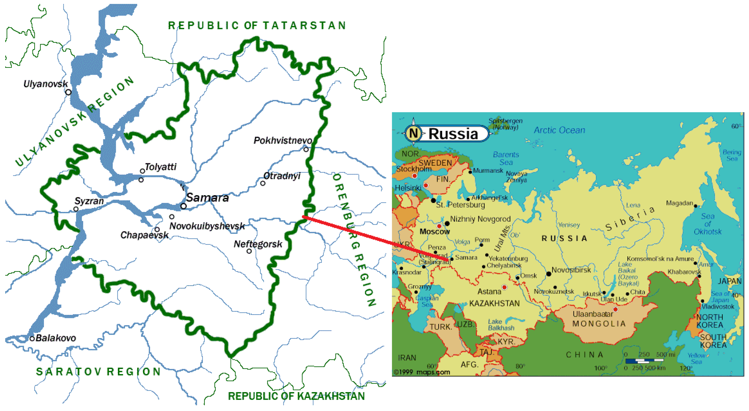
2.1. Geographical Characteristics

The Samara region [Figure 1] is located in the middle reaches of Europe’s largest river, the Volga, and consists of 27 administrative districts and the Samara–Tolyatti agglomeration. The Samara region covers an area of 53.6 thousand square kilometers (0.3% of the total area of Russia). The region stretches 335 km from north to south and 315 km from west to east. The Samara region borders the Republic of Tatarstan to the north, Kazakhstan, the Saratov region and the Orenburg region to the south, the Ulyanovsk region to the west, and the Orenburg region to the east.
The Samara region is one of the key regions in the network of the natural framework of the European part of Russia. The Samara region is located on the border of the Middle and Southern Volga regions, which determines its transit position and the presence of several natural zones on its territory. The uniqueness of natural resources, diversity of natural monuments, and extreme diversity of soils and plant associations are a consequence of very heterogeneous physical and geographical conditions within the Samara region. The heterogeneity of geogenic conditions and biological factors of soil formation, as well as the presence of several climatic zones, are complicated by the presence of the vast Volga basin, the influence of which on the above factors of soil formation contributes to the extreme diversity of soils and the formation of a significant number of intrazonal, relict, and unique soils. The largest water artery of the region is the Volga river, the flow of which is regulated by two reservoirs—the Zhigulev (Kuibyshev) Reservoir (ends near Togliatti) and the Saratov Reservoir (starts downstream from Togliatti). The Volga’s channel and sedimentation regimes have changed significantly due to flow regulation. The increase in the Samara region’s water surface area is also associated with this. The Volga is the largest river in the region and cannot be compared with the other “steppe” rivers. Nevertheless, the Bolshoy Irgiz, Bolshoy Kinel, Maly Kinel, Surgut, Samara, and Kondurcha rivers are the most important waterways in the forest–steppe and steppe landscapes.
In terms of tectonics, the territory of the Samara region is located in the elevated southeastern wing of the Russian Platform. The Precambrian crystalline basement of the platform lies at depths of between 1500 and 5000 m and is covered by sedimentary rocks from the Paleozoic, Mesozoic, and Cenozoic eras. The surface of the Samara region consists of rocks from the Carboniferous, Permian, Triassic, Jurassic, Cretaceous, Paleogene, Neogene, and Quaternary periods. The surface of the Samara region is composed of rocks of the Carbon, Permian, Triassic, Jurassic, Cretaceous, Paleogene, Neogene, and Quaternary systems. The oldest sediments—limestones and dolomites of the Carboniferous period—are exposed within the region on the Zhiguli upland. Permian, Jurassic, Cretaceous, and Paleogene sediments are developed in the area. The Jurassic system is represented in the Samara region by the middle and upper sections. The Middle Jurassic is composed of sands with sandstone lenses and clay interlayers, while the Upper Jurassic is composed of clays with various inclusions. Since the Jurassic clays contain high concentrations of sodium, salinized soils often form in areas where they are found. Permian rocks occupy a huge space in the left-bank part of the region. Their western limit is the Kondurcha r.—Khvorostyanka village. To the north of the B. Kinel and Kutuluk rivers, Permian sediments come to the surface almost everywhere; to the south of these rivers, they are found only in separate islands. Additionally, Permian deposits occupy a vast area on the Samarskaya Luka—in Zhiguli and along its southern edge. In other areas of the right bank, they are lowered very deeply and do not come to the surface anywhere. In the High Trans-Volga regions (Vysokoye Zavolzhye), the sediments of the Permian system are dominated by rocks of the Tatar stage of the upper section: clays of pink, red, and brown color, interbedded with marls of different colors, limestones, sands, and sandstones. Soils of the Bugulminskaya–Belebeyevskaya upland and Sokskiye and Kinelskiye yars (uplands), as well as soils localized in the basins of the Bolshoy and Maly Kinel rivers, in the Samara river valley and in the right-bank part of its basin are formed on the eluvium of the Tatar stage rocks. The entire southeastern part of the Volga region, located south of the Samara river, is composed of rocks of the Triassic and Jurassic systems. Triassic sediments are often exposed on the slopes of watersheds. They consist of red-brown, yellow, gray sands and red and green thinly layered clays with thick, obliquely placed conglomerate slabs. The Upper and Middle Jurassic sediments are distributed on the watersheds of the Blue Syrt, in the upper reaches of the Chapaevka, Bolshoy Irgiz, Syezhezha, and Karalyk, where they are located in a complex with Triassic rocks. Separate massifs of the Upper and Middle Jurassic sediments are located in the westernmost part of the lowland Trans-Volga region. The depressions of the ancient relief, made by Pliocene sediments, are confined to the chest clays. Compared to the Pliocene, they occupy a considerable space. Syrtic clays for the first time were described in detail by I.P. Gerasimov [11]. Syrtic clays are characterized by brown and gray-brown color and by the presence of large calcareous–gypseous nodules. Normally, they are covered by loess or loess-type loams.
Volga terraces: The Mindel terrace consists of straw-yellow fine-grained sands with bands of coffee-colored clayey material. The Riss terrace is composed of brown and yellowish sands, with pockets of quartz sands. The Wurm terrace consists of clayey sands, often replaced by light brown loams.
The most superficial parts of the Earth’s crust in the Samara region consist of Quaternary system rocks, which are the main soil formers. Among these sediments, one can distinguish cheese clays as well as ancient alluvial and modern alluvial sediments and delluvial and eluvial formations.
The region’s landscape has been greatly transformed by humans due to mining, urbanization, and agricultural development. Agrogenic soil degradation is widespread. Some of the arable land has now become fallow. In physical and geographical terms, the region is extremely heterogeneous [12,13]. The most general distinction is between forest–steppe and steppe biomes, although dry-steppe ecosystems can be found in the southeast of the region. Meanwhile, the right bank of the Volga is characterized by the Volga upland and the city of Samara. The High Trans-Volga region is represented by red-colored soil-forming rocks. Sandy deposits of alluvial origin, often saline, are common in the low-lying Trans-Volga region. A separate area is the territory of the syrtic hills. The distribution of ancient sand rocks of aeolian origin is quite widespread in the left bank, as well as in the territory of the Buzuluksky Bor protected area, which leads to extremely specific soils and vegetation cover. By the way, the soil cover is preserved as part of this national park, as well as two more protected areas of federal significance—Samarskaya Luka national park and Zhiguli state reserve. The climatic zone according Köppen [14] is DFa. The annual precipitation in the north reaches 580 mm, in the south it decreases to 460 mm [6], respectively, the evaporation rate varies from 600 mm to 850 mm, and thus the coefficient of humidification varies from 0.96, which corresponds to a forest–steppe climate of 0.70, which already allows classification of the landscape as dry-steppe with a significant moisture deficit. The annual temperature is about 7.0 °C in Samara city, about 6.0 °C in the northern part of the region and 7.1 °C in the southern part of the region. The highest ridge in the region is 381.2 m a.s.l., located on Zhiguly mountains, and the lowest—about 28 m—in the Volga floodplain. In general, the relief of the region is very strongly dissected, with a pronounced basis of erosion, a developed ravine–girder network, and deeply embedded rivers. All this contributes to the release of a wide variety of Quaternary and pre-Quaternary sediments to the surface. Other features of the nature of the region will be discussed below in the description and characterization of soils.

2.2. Field Survey

From 2001 to 2023, field studies were conducted during expeditions by Saint Petersburg State University and the Institute of Ecology of the Volga Basin in the Samara region and neighboring areas (see Figure 2). In total, more than 550 soil sections were described. The main research methods employed were comparative-analytical and comparative-geographical. The analytical methods described below were employed to further clarify the taxonomic position of the soils.

2.3. Soil Taxonomy

In Russia, there are different approaches to soil classification and taxonomy. One of them is traditional—factor-genetic, according to the old classification and diagnosis of soils [15], based on zonal aspects of soils and soil cover. We, in theory, rely on it. However, since one of the tasks of our work was to reveal the lithogenic specificity of the soils, we used a newer method—the substantial-profile classification of soils, developed in Russia—to reflect the morphological specificity of individual profiles [16]. Ideologically, the last classification [16] is much like WRB [17].

2.4. Laboratory

Soil samples were ground and passed through a 2 mm mesh to obtain fine earth. All analyses were conducted on the fine earth after the skeletal fraction was weighed. The total contents of C and N in plant materials were determined using an element analyzer (Euro EA3028-HT Analyser, Pavia, Italy). The pH levels were correspondingly measured potentiometrically with a soil-to-water ratio of 1:2.5 and 1:25 for mineral and organic horizons. The carbonate content was determined by the wet method with the addition of 1 M hydrochloric acid and measuring of the soil mass loss after treating soil with hydrochloric acids (gravimetric approach). Soil texture was determined on the basis of the classical sedimentation method [18].

3. Results and Discussion

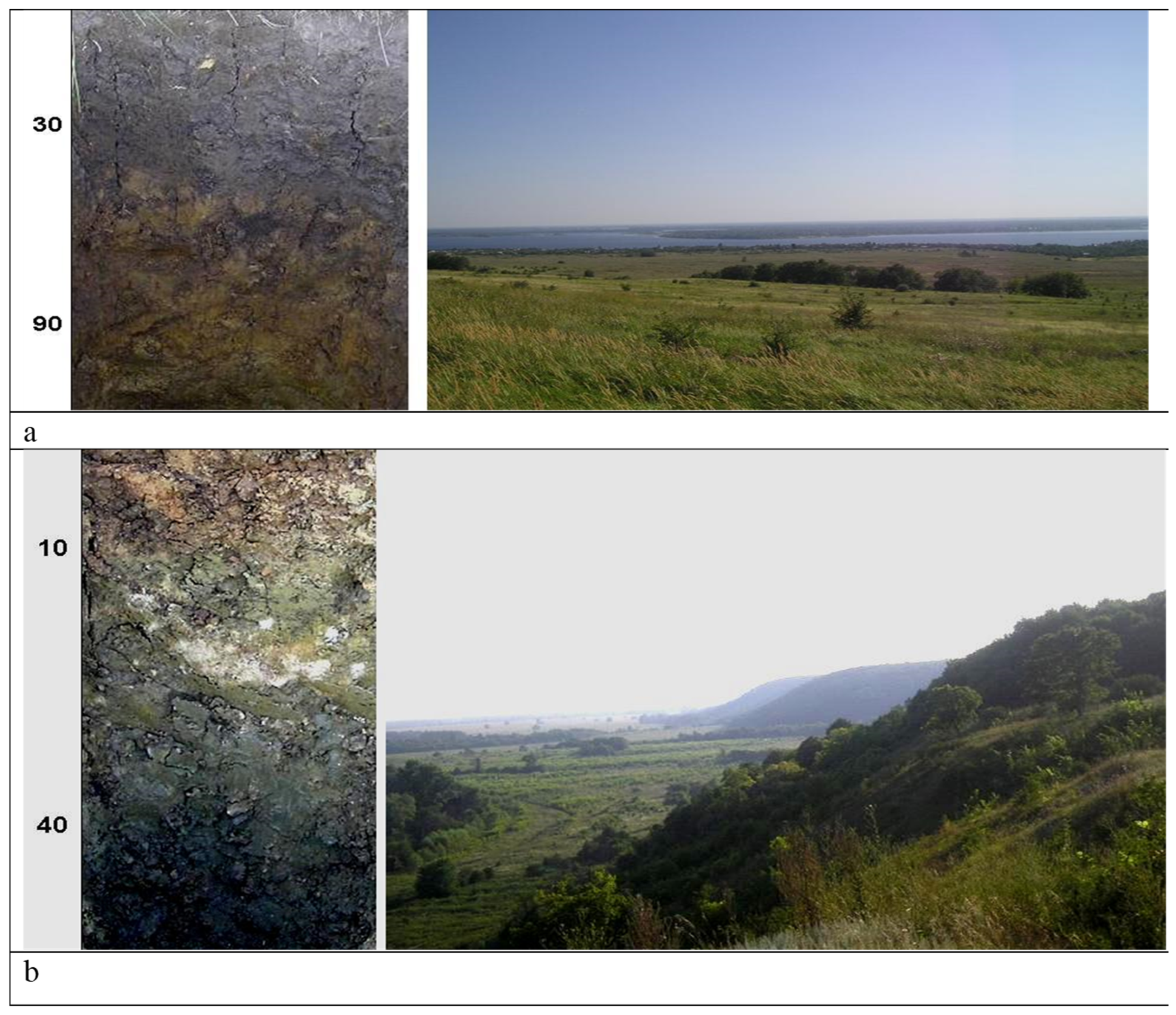
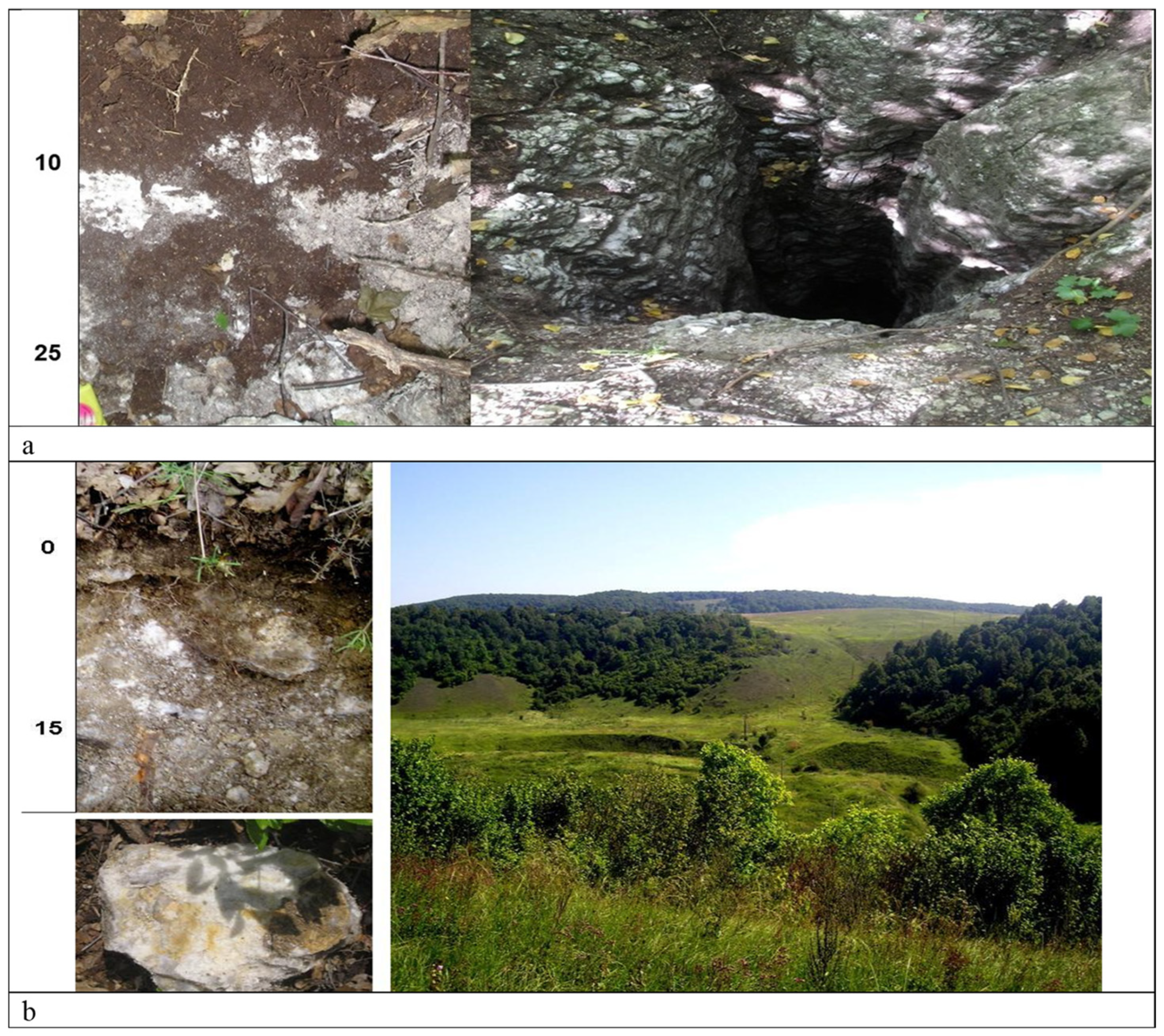
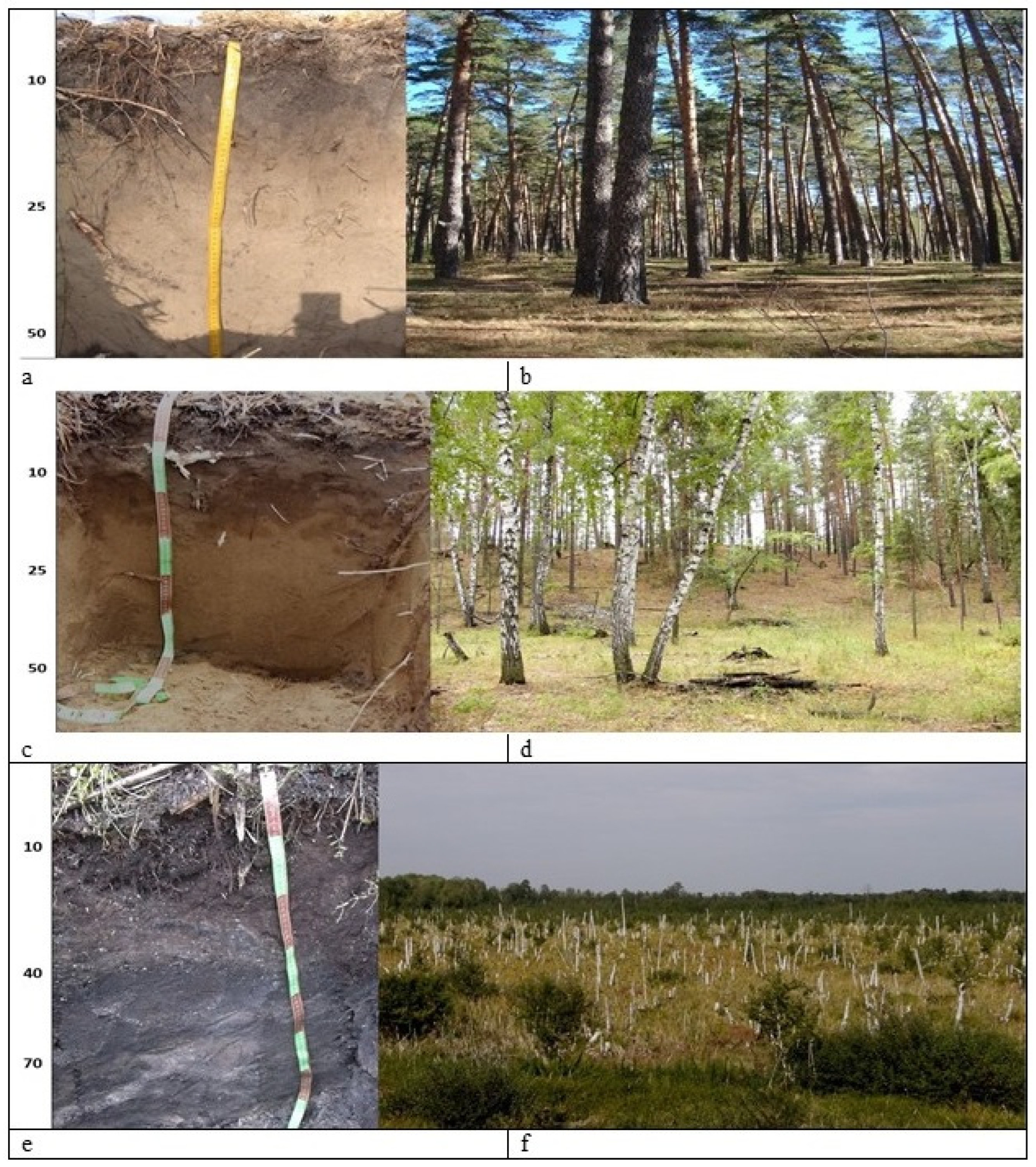
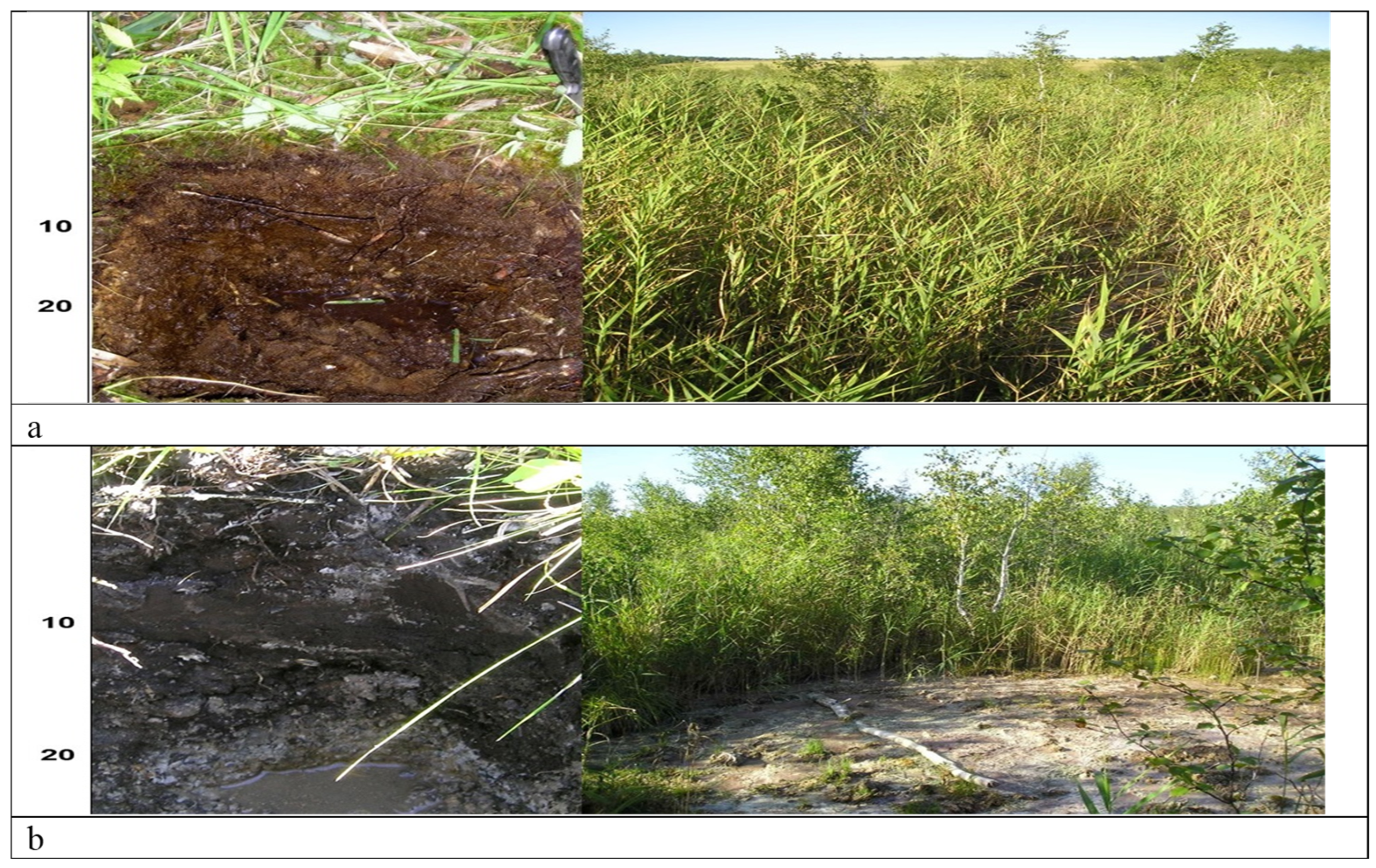
3.1. Soil Diversity, Morphology, and Genesis

The diversity and morphology of soils was reported in the fundamental monograph by V. A. Nosin (1949) [8]. This work summarizes the long-term work of the renowned group of scientists known as the “Samara pedologists”, and contains numerous solum descriptions and diagnostics. Since then, soil studies have been carried out with varying intensity. At the beginning of the twenty-first century, studies of the soils of the Samarskaya Luka peninsula (in the central part of the Samara region) were resumed. This area has been the subject of more soil studies than any other area in the region to date [3,9,10].
When it comes to typical representatives of forest–steppe soils, we are talking about solums of the same soil types, as well as steppe soils of the Phaeozem and Chernozem types (see Figure 3). This is indeed the case for levelled surfaces of uplands and flat valley bottoms. However, this rule works only in case of the presence of soil-forming parent materials represented by a deluvium of bedrock, slightly overlapped from above by loess-like sediments containing increased concentrations of coarse dust.
Figure 3. Zonal representatives of Samara region soils. Samarskaya Luka peninsula. (a) Retisol, watershed, broad-leaved forest, (b) Retisol—denudational valley, fine–broad-leaved mixed forest, (c) Phaeozem, denudational valley, meadow steppe, (d) Chernozem Calcaric, watershed, typical steppe.
Earth 06 00046 g003
It is remarkable that the soil profiles of Retisols—dark colored soils with weakly developed features of eluviation–illuviation of clay of the central part of Samara region—are essentially shallower than solums of the same soil type, developed on loess and loess-like substratas of more western region—Middle Russia upland, as established by Uruzevskaya et al. [5]. Nevertheless, these soils are typical zonal soils for forest–steppe zones [19,20]. They have a well-pronounced humus accumulation horizon AU with a thickness up to 50–70 cm, which transitions to an eluvial horizon AEL of 10–15 cm thickness, changed by a clay illuvial horizon BI (BT) with numerous argilans and cutans covering well-developed crumb aggregates. Such soils are endangered both in Russia and in the world, as relatively underinvestigated forest areas in the forest–steppe are becoming rare [21], and the forest–steppe itself is being degraded and repopulated by humans. Since the “upland” or, better to say, “plakor” (i.e., watershed leveled plain covered by grassland vegetation or forests stand) of the Volga upland, which emerged at the beginning of the Holocene [22], is degrading, the Retisols of these forests should be considered as special objects of soil protection. In Russia, there is currently an article of the law on environmental protection, which speaks about the need to create regional Red Books of soils of the Subjects of the Russian Federation [23]. Two neighboring regions already have Red Data Books of soils—the Republic of Tatarstan [24] and the Orenburg region [25]. The creation of the Red Book of Soils in the Samara region would supplement the information on soil diversity of the natural framework of this part of the European part of Russia as a whole.
The zonal Chernozems of the Samara Oblast and Samarskaya Luka in particular are divided into watershed and valley types of Chernozems. Watershed Chernozems as a rule are more drained and carbonated and are distributed in typical Stipa sp. (feather grass) steppes (Figure 3a–d). Valley Chernozems (Figure 3c) have a deeper, leached profile with a lower carbonate content and are confined to meadow steppes. As a researcher of similar soils from the neighboring region (the Orenburg region) A.I. Klimentyev [26] wrote that the facial peculiarity of soils of these territories is a special influence of geoplastic relief on the formation of soil diversity and their spatial differentiation. In this sense, the significant dissection of the relief and pronounced erosional dissection of the terrain leads to a rapid spatial change in soil types and subtypes in the Samara region from west to east and from north to south. At the same time, the specificity of morphological organization, taxonomic position, and peculiar shortening of the vertical solum of Chernozems in the Samara region, caused by the specificity of soil-forming parent materials in the region, were noted earlier [27]. If even the zonal deep-profile soils of a region have specific features, it is clear that the lithogenic soils will be even more distinctive.
The northeast of the Samara region is located on the uplands and watersheds of the High Trans-Volga region. This area is characterized by the near-surface occurrence of Permian red-blossom rocks, which we also find in the adjacent regions—Tatarstan and Orenburg. Permian rocks are predominantly red-colored and carbonate. Both features are inherited, in some case from red-colored substrates [28]. In general, the phenomenon of red-colored soils formed on red-colored and chestnut rocks is very interesting [29]. Red-colored rocks strongly change the course of soil formation process and morphological organization of soils. In this connection, in 2008, the Field Identifier of Soils of Russia [30] proposed the allocation of an independent morphological feature of soils at the genus level, denoted by the symbol “ro”, meaning red-colored.
Examples of red-colored soils and parent materials of the High Trans-Volga region are presented in Figure 4. The first solum (Figure 4a) represents Chernozem soil with features of clay leaching and illuviation type according to soviet soil taxonomy [14]. According to current Russia soil taxonomy [16], it could also be possible to determine this soil to be like a Chernozem because the thickness of dark-humus colored layer AU is more than 30 cm in depth. At the bottom of this horizon, there are illuviation cutans of clay. Thus, this is leached Phaeozem or Chernozem and one can add an additional qualifier—“red-colored” or “red-profiled”. Thus, the central forest–steppe of the High Volga region is characterized by the presence of at least an extremely specific lithogenically conditioned genus of black earth soils—red-colored soils. Another example of red-colored soils is shown in Figure 3b. This is a soil of fallow farmland located next to active arable land. This soil can also be classified as red-colored Chernozem, on the deluvium of red-colored Permian rocks underlain by limestone sediments. The surface of the field is strongly disturbed by surface water erosion due to the increased density and low infiltration capacity of the parent materials. Slope processes—water erosion and material crumbling—are also characteristic of unplowed slopes, where dense red-colored rocks approach the terrain (Figure 4c). It is probably possible to find Retisols on reddish-colored rocks under the upland oak forests that still remain in some places in the northeast of the region, but this could be the subject of a separate study. In any case, following I.S. Urusevskaya [5], we expect their profile to be shortened, as shown in Figure 4 and for Chernozems.
Figure 4. (a) Red-colored virgin soil (Phaeozem) and steppe in High Trans-Volga region, (b) post-arable abandoned red-colored soil (Phaeozem) and agricultural slope erosion in High Trans-Volga region, (c) slope erosion of red calcaric limestones exposed on slopes.
Earth 06 00046 g004
We will also consider the characteristics of soils formed in the southern forest–steppe and wall zones on syrtic sediments. The origin of syrtic uplands is still a matter of debate. Syrtic uplands are widespread in the south-eastern part of the Samara region, the Saratov and Orenburg regions, Kazakhstan, and other regions in Central Asia. Lithologically, syrtic deposits overlie red-colored sediments which come to the surface in the northern part of the Samara region. The uplands proper are composed of Cretaceous sediments and Akchagyl Sea deposits [30]. Syrtic clays, also known as “brown steppe clays”, are interbedded with sandy loam and are presumably of ancient alluvial origin. In the upper part, they often contain loess-like sediment admixtures [31,32]. They may have formed on Pleistocene extra-glacial uplands where freshwater and brackish bodies of water were formed, which may partly explain the slight salinization of some syrtic parent materials. The upper layers of syrtic clays are often carbonate. These clays are characterized by a high bulk density and an abundance of cracks.
Figure 4 shows the following: The main types of automorphic landscape in the syrtic uplands of the Samara region are presented. In the southern forest–steppe, Phaeozem (Figure 5a) is found on clay soils with low carbonate concentrations. Widespread in the northern typical steppe are typical Chernozems (Figure 5b) with diffuse accumulation of secondary carbonate in the middle solum. Ordinary calcaric Chernozems (Figure 5c), which have very well-expressed secondary carbonate nodules, are found in the central and southern steppe zones. On the border between the Samara and Saratov regions, in the dry steppe area, the driest analogue of Chernozems can be found: chestnut soils (Figure 5d). Thus, clear latitudinal zonality is evident within the semi-arid subboreal belt of the High Trans-Volga uplands. However, in areas with relatively flat plateau terrain, the zonal series is again established, albeit with pronounced regional specificity, despite the extraordinary spatial lithogenic contrast of rocks in Samarskaya Luka significantly disrupting and chaotizing the usual zonal course of spatial distribution of the soils.
Figure 5. Soils of the syrtic uplands of Samara region. (a) Phaeozem. (b) Typical Chernozem. (c) Ordinary Calcaric Chernozem. (d) Kaztanozem (chestnut soil).
Earth 06 00046 g005
A typical topographic combination of soils of typical steppe on syrtic loams is shown in Figure 5. On the edge of the watershed plakor (Figure 6a), there is typical carbonate Chernozem on brown syrtic clay under typical steppe vegetation. In mezzo depression, in this particular case—in the ravine, there is Solonetz—dark-colored soil with an increased sodium content in the soil cation exchange complex is formed (Figure 6b).
Figure 6. Topographic combination of soils in relief. (a) Typical Chernozem on the syrtic clays of the watershed; (b) Solonetz in the accumulation depression in the ravine.
Earth 06 00046 g006
In previous publications, we discussed the specifics of Chernozem soils formed on the sediments of the Akchagyl transgression [3]. In addition to these pre-Quaternary sediments, other pre-Quaternary sediments, such as Khvalyn clays, are widespread in the Samara region. Vertic-type soils are confined to such sediments [33]. These loamy and clayey sediments are dense, compacted, and broken by deep vertical cracks. Since they are located in the Chernozem-steppe zone, they are similar to Chernozem soils, but they exhibit vertic features, which has been previously confirmed for many Volga region soils formed on similar parent materials [34]. Vertic Phaeozems and Chernozems soils are formed on loamy sediments (Figure 7a). On denser clays, poorly developed humus accumulative soils are formed (Figure 7b). Thus, Phaeozem formation on Khvalyn clays is weaker than on loess-like loams, which once again confirms the conclusions obtained earlier by I.S. Urusevskaya et al. [5] on the specificity of forest–steppe and steppe pedogenesis under the influence of various parent materials.
Gypsiferous rocks very rarely act as soil parent materials in the East European Plain. Nevertheless, S.V. Goryachkin [35] describes them as an independent variant of Petrozems—Gypsopetrozems (Gypsolithozems)—Calcic Leptosols. These are variants of the Primary soils division (in the current Russian soil taxonomy [16]), differing from Carbopetrozems and Carbolithozems by the fact that they develop on gypsum-containing parent materials, inherited from quite specific dense rocks. An example of Gypsic Leptosol is provided in Figure 8a. Outcrops of gypsum rocks or close proximity to the surface are observed in several other points of the Samara region, in particular, in the vicinity of Samara city proper. It should be noted that possible finds of similar gypsum soils are predicted in the Middle Volga region, where according to statistics, a significant part of gypsum deposits in Russia are located [35].
Soils formed on the sandy-textured substrates in the steppe of the Samara region are presented in Figure 9.
Figure 7. Soil on the Khvalynsk clays of Samarskaya Luka. (a) Phaeozem vertic. (b) Umbrisol vertic.
Earth 06 00046 g007
Figure 8. (a) Gypsic Leptosol on the weathering material of gyps and gypsum mining since the time of Peter the Great, Samarskaya Luka; (b) Gypsic Leptosol on the exposures of gypsum, Vinnovka settlement, surroundings of the Samarskaya Luka.
Earth 06 00046 g008
Figure 9. Soils on sandy-textured substrata. (a) Sod soil under (b) pine stand in forest–steppe zone, Tolyatti city surroundings; (c) Sod soils on the sand dunes of Buzuluksky Bor special protected area under (d) birch forests in forest steppe zone, border of Samara and Orenburg regions; (e) Eutrophic peat soils of rump peatland of Buzuluksky bor; (f) Eutrophic peat between sandy dunes of Buzuluksky Bor border of Samara and Orenburg regions.
Earth 06 00046 g009
In the forest–steppe and steppe zones of the Russian Federation’s European territory, loamy-clay loess-like parent materials are prevalent. Zonal Retisols and Chernozems of various types and variants dominate these territories. In the same places, where alluvial, aeolian sands and sandy loam, as well as similar deposits of other genesis come to the surface, non-zonal soils—“seropesky soils”—are formed [35], although it is difficult to relate them to intrazonal soils (Figure 9a–f). The phenomenon of the soil-organization process on them consists of the fact that the classical thick accumulative-humus profile is not formed. At the same time, these soils do not resemble Arenosols or Primary soils proper. In them, the thickness of the humus horizon AY can reach 20–30 cm, and in its lower part a layer with eluvial features can be formed; then, this horizon is designated as AYe. At the same time, no independent illuvial horizon is formed. Thus, these are neither Chernozems, nor Retisols, nor Podzols. These are specific gray-humus sandy soils of island pine forests, and more rarely of small-leaved forests.
A typical representative of the “seropesky” soil (Eutric Arenosol (Humic)) profile is provided in Figure 8a. This soil is comparable in terms of genesis with those reported previously for the Rostov region [36]. These soils prevail on the tops and slopes of sandy dunes, covered by pine stand within the whole protected area of Buzuluksky bor, which is located in the territory of two regions of Russia—Samara and Orenburg [37,38]. In the same territory, in the inter-dune depressions, one can find more humid landscape positions (Figure 9c,d) with soils of the same Arenosol type but with more pronounced humus accumulation and a darker-color AY layer. It is necessary to emphasize that one of the key morphological differences in zonal soils—Chernozems and Retisols—is the presence of the dark humus horizon AU [15], while in sandy soils of island pine forests, the upper horizon is represented by a gray humus horizon—AY. However, the rate of humification in the soils of these pine forests is higher than in the southern taiga subzone, due to which the forest litter is almost not expressed and in most cases is not subdivided into sub horizons according to the degree of decomposition and humification of organic matter.
As we mentioned earlier, the work [6] noted that, in the Volga region, relatively northern ecosystems extend further south along sandy rocks, and relatively southern ecosystems extend further north along carbonate rocks. The same can be said of soils. If island pine forests are recognized as one of the most stable southern variants of forest pine formation, then areas of non-zonal soils are found here. The phenomenon of pine forests forming on sandy sediments in the steppe zone and Chernozem soil environments is of great interest in terms of parameterizing the influence of plant edifiers on soils. The productivity and species composition of vegetation changes in the forests themselves and in the ecotone zone around them [39].
Extended eutrophic bogs with bumps can form in extensive depressions between dunes. These bog ecosystems are dominated by peaty eutrophic soils (Figure 9e,f) with increased organic matter content. Thus, the presence of extensive sandy landscapes of hilly type in the steppe zone interrupts the typical latitude zonality. This indicates that the role of the lithological factor in the formation of classical zonality is underestimated towards bioclimatogenic conditions of soil formation.
The idea proposed by A.M. Rusanov et al. [40] is interesting: due to the existence of such areas of forests and soils, a forest–steppe ecotone up to 20 km wide forms on steppe territory, resulting in a peculiar inversion of natural zones. We would like to add that this inversion is largely caused by geogenic factors, particularly lithological factors. The chemical specificity of the soil substrate can result in changes to soil enzymatic activity. Thus, the role of the lithological factor in regulating biological soil properties should be emphasized in the near future [41,42].
Salinized soils are widespread in subboreal ecosystems, including the Samara region. These soils typically include Solonchak, Solonetz, and Solod types. Additional salt accumulation in soils leading to salinization can be lithogenic and related to salt movement in landscapes with altitude differences (here, we do not consider irrigation salinization). In general, salinized soils in forest–steppe and steppe areas are not dominant or zonal; in this sense, they are almost always confined to specific lithogenic factors. The soils in the Samara region have been described in detail previously [8]. Therefore, we only present the most characteristic examples in Figure 10 here. Figure 10a shows Solonetz soils, which are enriched with exchangeable Na as part of the soil-absorbing complex. The middle part of the solum is very dense and has a clumpy structure.
Figure 10. Salinized soils. (a) Solonetz, (b) magnesium Solonchak, (c) sodic Solonchak, (d) lithogenic Solonchak.
Earth 06 00046 g010
Figure 10b shows magnesium-chloride Solonchaks, which change in volume during the day due to the swelling and drying of fine-grained soil saturated with magnesium salts. These Solonchaks are often referred to as “puffed Solonchaks” precisely because of their variable volume. Solonchaks have a much higher intensity of salt accumulation than Solonetz soils. Consequently, they are covered with halophytic vegetation rather than steppe vegetation.
Sodic Solonchak soils are the most toxic. The presence of sodium leads to an extremely high alkalinity of the soil, and because of this, very often the soil surface is lifeless and polygonally cracked, and the Takyric qualifier is often applied to them. An example of a sodic Solonchak is given in Figure 10c. Magnesium-chloride and sodic Solonchaks in this case are not lithogenic, i.e., their salts are not inherited from the parent materials, but additionally accumulated in depressions due to movement in relief. Lithogenic Solonchak, where salts are inherited from the soil-forming rock, is not typical for forest–steppes and steppes; however, it is sometimes found on watershed areas (Figure 10d). In these soils, salts can only be detected analytically and by the presence of halophytic or conditionally halophytic vegetation in the plant community.
Another type of salinization is sulfidic salinization. This is associated with the development of reducing conditions in areas with excess moisture. Such locations are widespread in closed meso-depressions, which are quite typical of regions with pronounced topography—a category to which the region we are describing belongs. Figure 11a shows a Histic Sulfidic Solonchak soil, while Figure 11b shows a Sulfidic Solonchak soil. The habitats of such soils are very small. Nevertheless, these soils are important for understanding and fully assessing soil diversity and the specificity of biogeochemical conditions in the Samara region.
Figure 11. Sulfidic soils. (a) Sulfidic Histosol, (b) Sulfidic Solonchak.
Earth 06 00046 g011

3.2. Soil Analytical Characteristics

Zonal Retisols exhibit a high concentration of organic carbon in their superficial humus-accumulative horizons (see Table 1). The low C/N ratio indicates a high degree of soil organic matter in relation to nitrogen. Retisols in denudational valleys demonstrate higher percentages of carbon, which correspond well with the thickness of the deeper AU horizon. Thus, in the case of a denudational valley, the accumulation of carbon and nitrogen is more pronounced due to the type of vegetation cover—forest with forest edges occupied by meadows. Both Retisols have a pH value close to neutral and contain carbonates only in the parent material, while the rest of the solum has been leached. Eluvial-illuvial differentiation is not strong; some clay accumulation is fixed in the BI and BC horizons.
As for the zonal Chernozems (Phaeozem and Chernozem), they demonstrate a higher organic matter content than Retisols. Chernozem Calcaric has more carbon than Phaeozem. The enrichment of organic matter by nitrogen is comparable to the Retisol index. Chernozem soil reliably indicates the presence of carbonates in the fine earth of the entire soil profile, from the topsoil to the parent material. The relatively high clay content is due to the loess-type parent material. Phaeozems, formed on red-colored parent material, demonstrate a lower humus content than Chernozemic soils formed on loess-like loams. Agric red-colored soils have a lower percentage of organic matter than mature ones, and this could be a result of water erosion developing on the surface of arable soil.
Soils on syrtic clays and loams represent a climatic sequence: Phaeozem—Chernozem Calcaric—Kastanozem. The highest organic carbon content was revealed in Chernozem Calcaric. Kastanozem demonstrates a lower humus portion with a lower thickness of the humus-accumulative horizon. In this soil sequence, there is an increment of carbonate content from north to south, which corresponds well with the pH values. Solonetz is soil characterized by a more alkaline reaction in comparison with Chernozem, resulting from the presence of exchangeable sodium in the fine earth. Due to the accumulation of sodium, Solonetz looks darker than the related Chernozem. This is a result of humus peptization and increasing mobility in the case of sodium salinization. Soils with vertic properties—Phaeozem and Umbrisol—have a low content of organic matter. It is quite possible that the high soil density does not allow the vegetation to develop well, which is why the productivity of the ecosystem is low and little humus accumulates.
Leptosols formed from gypsum debris have a low organic matter content and low humus enrichment by nitrogen in superficial layers and pH values close to neutral. Some of these soils are hyperskeletic due to the presence of gypsic stones inherited from the parent material.
Soils formed on sandy-textured parent materials differ in terms of their chemical characteristics when we compare soils formed on the top of dunes, in depressions, and in peatland. The inter-dune location is favorable for more intensive accumulation of organic matter. This process is essentially more pronounced in Histosol Eutric. The salinized soils demonstrate typical features of these soil groups. Solonchaks are less enriched by organic matter than Solonetz. This could be a result of the toxicity of Solonchaks, which causes even halophytic vegetation to be low in productivity. The most alkaline reaction is typical of sodic Solonchaks, while the lowest pH values, close to neutral, are typical of sulfidic Solonchaks.

4. Conclusions

The latitudinal zonality of soils is most clearly manifested in the western and central regions of the East European Plain. This phenomenon was first observed by V.V. Dokuchaev, the founder of soil science. Classification and taxonomic schemes of soil science work most clearly and accurately here. In more eastern regions, for example, in the Volga upland and the High Trans-Volga and syrtic uplands, the usual zonal shape of soils is affected by continental factors and changes in a less typical way. This is sometimes unrecognizable, which is promoted by the specificity of the geogenic factors—parent materials and relief—that are considered in this article. Zonal soils are normally the dominant type in watersheds and denudation valleys composed of loess parent materials. Where exotic pre-Quaternary rocks emerge closer to the surface, lithogenic soil types are formed, such as vertic, red-colored, gypsum and halomorphic soils. The pedodiversity of the region increases sharply in this connection, which should be taken into account when organizing soil mapping, planning measures for special soil protection, and organizing economic activities. The substantive profile classification of soils in Russia was tested in the Samara region to determine whether the current classification has sufficient apparatus and diagnostic criteria to account for all possible morphological diversity in the region.

Funding

This work was funded by Saint Petersburg State University, Project No. 123042000071-8.

Data Availability Statement

The original contributions presented in this study are included in the article. Further inquiries can be directed to the corresponding author.

Acknowledgments

This manuscript is dedicated to the memory of Professor Sergey Saxonov, (vice director, Zhiguli State Reserve of Russia and Deputy on Science of Volga Basin Ecology Research Institute, who passed away during the pandemic of COVID-19), and to a researcher who has performed much research on the region’s soils in the Samara region (burned and created in Samara city), Professor Elvira Gagarina, Saint Petersburg State University, who passed away in Saint Petersburg, 2022.

Conflicts of Interest

The authors declare no conflicts of interest.

Abbreviations

Designation of soil horizons (according to WRB soil taxonomy [15]):
AYGray humus horizon, unsaturated
AUDark humus horizon, saturated, neutral, or alkaline pH
AUv Dark humus horizon, saturated, neutral, or alkaline pH
BCAHorizon of secondary carbonates—protocalcic
BCAcs, caHorizon of secondary carbonates—protocalcic with Ca and CaSO4 inherited from parent materials
BCAmcHorizon of secondary carbonates—protocalcic with carbonate mycelium—mc
BCA mc, nc, dcHorizon of secondary carbonates—protocalcic with carbonate mycelium—mc, carbonate noodles—nc, carbonate in disperse noodle form—dc
BCcaCalcaric accumulation of Ca in BC transitional horizon
BMKXerometamorphic horizon
BIHorizon of clay illuviation, unsaturated
BIvHorizon of clay illuviation, unsaturated with vertic properties
BSNSolonetz–illuvial horizon
BSNvSolonetz–illuvial horizon with vertic properties
TEHistic eutric horizon of the peat
TEsHistic eutric horizon of the peat with salts accumulation
SSalinized horizon with easily water soluble salts
CParent material
CsParent material with accumulation of easily water soluble salts
CqParent material with features of gleyification in neutral or alkaline media
CcaParent material with Ca, inherited from parent material—calcaric
AJSGray humus horizon with accumulation of easily water-soluble salts
AUroDark humus horizon, saturated, neutral, or alkaline pH with red color inherited from red-colored parent materials
BiroHorizon of clay illuviation, unsaturated with red color inherited from red-colored parent materials
CroParent material with red color inherited from red-colored parent materials
PUroArable (agric) dark humus horizon, saturated, neutral, or alkaline pH with red color inherited from red-colored parent materials

References

  1. Dokuchaev, V.V. Russian Chernozem; Russkaya Kollektsiya: Saint Petersburg, Russia, 2008; 480p. [Google Scholar]
  2. Gagarina, E.I. Lithological Factor of Soil Formation (on Example of North-West Part of Russian Plain); Saint-Petersburg State University: Saint-Petersburg, Russia, 2004; 257p. [Google Scholar]
  3. Abakumov, E. Pedodiversity of Subboreal Ecosystems under Contrasting Geogenic Factors (Case Study of Samarskaya Luka, Middle Volga Region, Russia). Geosciences 2022, 12, 443. [Google Scholar] [CrossRef]
  4. Sokolov, I.A. Soil formation and time: Polyclimaxes and polygenetic of soil. Soil Sci. 1984, 2, 102–112. [Google Scholar]
  5. Urusevskaya, I.S.; Khokhlova, O.S.; Sokolova, T.A. Influence of soil-forming rocks on differentiation of soil cover of the northern part of the Privolzhskaya Upland. Eurasian Soil Sci. 1992, 8, 22–37. [Google Scholar]
  6. Kolomyts, E.G. Boreal Ecotone and Geographical Zonality; Atlas-Monograph: Moscow, Russia, 2005; 390p. [Google Scholar]
  7. Chizhikov, P.N. The Map of Parent Materials of the European Part of the Soviet Union; MSU: Mocsow, Russia, 1968; 1p. [Google Scholar]
  8. Nosin, V.A.; Agafodorov, I.P.; Krylov, V.P.; Sitnikova, B.L. Soils of Kuibyshev Oblast, 1st ed.; Prasolov, L.I., Ed.; OGIZ: Kuibyshev, Russia, 1949; 382p. [Google Scholar]
  9. Abakumov, E.V.; Gagarina, E.I. Soils of Samarskya Luka: Diversity, Genesis, Protection; Saint-Petersburg-State University: Saint Petersburg, Russia, 2008; 153p. [Google Scholar]
  10. Ivanov, I.V. The soils of the Povolzhye. In Proceedings of the X International Congress of Soil Scientists, Kuibyshev, Russia; USSR Academy of Sciences, Institute of Agrochemistry and Soil Science: Puschino, Russia, 1974. [Google Scholar]
  11. Senator, S.A. The natural zoning of the Samara region in the works of various researchers. Samara Luka Probl. Reg. Glob. Ecol. 2015, 24, 6–37. [Google Scholar]
  12. Nature of the Kuibyshev Region; Oblastnoye Isdatelstvo-OGIZ: Kuibyshev, Russia, 1951; 382p.
  13. Cui, D.; Liang, S.; Wang, D. Observed and projected changes in global climate zones based on Köppen climate classification. WIREs Clim Chang. 2021, 12, e701. [Google Scholar] [CrossRef]
  14. Egorov, V.V.; Ivanova, E.N.; Friedland, V.M. Classification and Diagnostics of Soils of the USSR; Kolos: Moscow, Russia, 1977; 225p. [Google Scholar]
  15. Shishov, L.L.; Tonkonogov, V.D.; Lebedeva, I.I.; Gerasimova, V.I. Classification and Diagnostic System of Russian Soils; Oikumena: Smolensk, Russia, 2004; 342p. [Google Scholar]
  16. IUSS Working Group WRB. World reference base for soil resources. In International Soil Classification System for Naming Soils and Creating Legends for Soil Maps, 4th ed.; International Union of Soil Sciences (IUSS): Vienna, Austria, 2022; Available online: https://www3.ls.tum.de/boku/?id=1419 (accessed on 21 March 2025).
  17. Rastvorova, O.G. Soil Physics (Practical Guide) Leningrad; Leningrad State University: Leningrad, Russia, 1983; 178p. [Google Scholar]
  18. Zakharov, K.K. Organic matter of soils of oak forests of the northern forest-steppe of the Volga Highlands (as an example of the Chuvash Republic). Sci. Proc. Cheboksary Branch Main Bot. Gard. Named After NV Tsitsin RAS 2018, 11, 40–49. [Google Scholar]
  19. Chendev, Y.G.; Burras, C.L.; Sauer, T.J. Transformation of forest soils in Iowa (United States) under the impact of long-term agricultural development. Eurasian Soil Sci. 2012, 45, 357–367. [Google Scholar] [CrossRef]
  20. Chendev, Y.G.; Aleksandrovskii, A.L.; Khokhlova, O.S. Anthropogenic evolution of dark gray forest-steppe soils in the southern part of the Central Russian Upland. Eurasian Soil Sci. 2011, 44, 1–12. [Google Scholar] [CrossRef]
  21. Boldyrev, V.A. Phytoindication of soils and soil-forming rocks in the forests of the southern part of the Volga Upland Vestnik of Russian Universities. Mathematics 2014, 19, 1254–1258. [Google Scholar]
  22. Article 62 “Protection of Rare and Endangered Soils” Federal Law of Russia 10.01.2002 N 7-FZ. Available online: https://www.consultant.ru/document/cons_doc_LAW_34823 (accessed on 22 March 2025).
  23. Aleksandrova, A.B.; Kulagina, V.I.; Berezhnaya, N.A.; Grigoryan, B.R.; Ivanov, D.V.; Kulagina, V.I. Red Book of Soils of the Republic of Tatarstan; Foliant: Kazan, Russia, 2012; 192p. [Google Scholar]
  24. Klimentev, A.I.; Chibilev, A.A.; Blokhin, E.V.; Groshev, I.V. Red Soil Book of Orenburg Region; Ural branch of Russian Academy of Sciences Russia: Ekaterinburg, Russia, 2001; 294p. [Google Scholar]
  25. Klimentiev, A.I. Soil-geographical zoning of the Orenburg region. Vopr. Steppeovedeniya 2005, 5, 83–95. [Google Scholar]
  26. Abakumov, E.V.; Gagarina, E.I.; Saksonov, S.V. Experience of application of classification and diagnostics of soils of Russia (2004) in soil research in the Samara region. Izv. Samara Sci. Cent. Russ. Acad. Sci. 2010, 12, 27–30. [Google Scholar]
  27. Abakumov, E. Rendzinas of the Russian Northwest: Diversity, Genesis, and Ecosystem Functions: A Review. Geosciences 2023, 12, 216. [Google Scholar] [CrossRef]
  28. Lesovaya, S.N.; Lebedeva-Verba, M.P.; Chizhikova, N.P. Genesis of soils developed from red-brown clays and loess-like loams in the southwest of the Central Russian plain (the Belogor’e reserve). Eurasian Soil Sci. 2008, 41, 1137–1147. [Google Scholar] [CrossRef]
  29. Field Identifier of Soils of Russia; Soil Institute Named After V.V. Dokuchaev: Moscow, Russia, 2008; 182p.
  30. Plaksina, T.I.; Artyomova, O.V.; Kalashnikova, O.V.; Katsovets, E.V.; Kortchikov, E.S.; Kudashkina, T.A.; Kuzovenko, O.A.; Yudakova, N.A. New materials on the flora of Syrt. Proc. Samara Sci. Cent. Russ. Acad. Sci. 2009, 1–4, 583–587. [Google Scholar]
  31. Gerasimov, I.P. On the genesis and age of Syrt sediments. Tr. Kom. Study Quat. Period 1935, 4, 273–287. [Google Scholar]
  32. Moskvitin, A.I. Quaternary Sediments and the History of the Formation of the Valley of the River Volga in Her Middle Flow; Proceedings of the Geological Institute: Moscow, Russia, 1958; 218p. [Google Scholar]
  33. Khitrov, N.B.; Rogovneva, L.V. Vertisols and vertic soils of the middle and lower Volga regions. Eurasian Soil Sci. 2014, 47, 1167–1186. [Google Scholar] [CrossRef]
  34. Goryachkin, S.V.; Spiridonova, I.A.; Targulian, V.O.; Sedov, S.N. Boreal soils of hard gypsum rocks: Morphology, properties and genesis. Eurasian Soil Sci. 2007, 36, 691–703. [Google Scholar]
  35. Khudenkikh, K.O. Peculiarities of distribution of sulfate rocks and associated gypsum deposits on the territory of the Russian Federation. Min. J. 2018, 3, 4–13. [Google Scholar]
  36. Chernova, O.V.; Bezuglova, O.S. Experience of using data of background concentrations of heavy metals in regional monitoring of soil pollution. Eurasian Soil Sci. 2019, 8, 1015–1026. [Google Scholar]
  37. Klimentiev, A.I. Buzulukskiy Boron: Soils, Landscapes and Geographical Environment Factors of Geographical Environment; Ekaterinburg, Ural branch of Russian Academy of Sciences: Syktyvkar, Russia, 2010; 400p. [Google Scholar]
  38. Kin, N.O. Flora of the Buzuluk bor (vascular plants). In Proceedings of the Scientific Station-Branch of the Institute of Steppe Ural Branch of RAS “Buzulukskiy Bor”, Ekaterinburg, Russia, 2009; 283p. [Google Scholar]
  39. Kin, N.O. The role of island forests of the Russian Plain at the southern limit of the Pinus sylvestris range in the conservation of phytodiversity of the regions of steppe and forest-steppe zones. Probl. Bot. South Sib. Mong. 2024, 23, 132–136. [Google Scholar]
  40. Rusanov, A.M.; Shein, E.V.; Prokhorova, N.V.; Alekhina, G.P. Ecology of steppe ecosystems adjacent to the forest. Vestn. Orenbg. State Univ. 2013, 10, 326–330. [Google Scholar]
  41. Zhou, N.; Han, X.; Hu, N.; Han, S.; Yuan, M.; Li, Z.; Wang, S.; Li, Y.; Li, H.; Rengel, Z.; et al. The Crop Mined Phosphorus Nutrition via Modifying Root Traits and Rhizosphere Micro-Food Web to Meet the Increased Growth Demand Under Elevated CO2. iMeta 2024, 3, e245. [Google Scholar] [CrossRef]
  42. Xing, W.; Hu, N.; Li, Z.; Feng, L.; Zhang, W.; Preez, G.D.; Zhang, H.; Li, D.; Lu, S.; Chang, S.X.; et al. Soil Enzyme Profile Analysis for Indicating Decomposer Micro-Food Web. iMeta 2024, 3, e161. [Google Scholar] [CrossRef]
Figure 1. Inset map of Samara region of the map of Russia.
Earth 06 00046 g001
Figure 2. Key soil survey plots in Samara region. Numbers correspond to Figure 3, Figure 4, Figure 5, Figure 6, Figure 7, Figure 8, Figure 9, Figure 10 and Figure 11.
Earth 06 00046 g002
Table 1. Soil chemical characteristics and texture.
Soil HorizonDepth, cmTOC, %TON, %C/NpH/H2OCaCO3Sand %Silt %Clay%Skeleton %Fine Earth, %
2a Retisol, (watershed Ca) zonal soil
AU0–403.600.409.06.00.00452530595
BEL40–551.750.257.06.50.004822341090
BT55–750.850.0614.25.80.004619351090
BC75–950.600.087.55.90.002727461585
C95–1200.350.057.05.90.502924471787
2b Retisol, (denudational valley) zonal soil
AU0–254.500.587.76.80.00491536397
AU25–502.900.348.56.50.00521335595
BEL50–701.900.1413.56.80.00491437793
BC70–900.600.096.76.90.005112371090
C90–1100.550.0413.87.00.464620341288
2c Phaeozem (Chernozem Luvic, watershed) zonal soil
AU0–205.850.787.56.00.00234532595
AU20–405.400.806.86.00.50283636595
BI40–553.900.557.15.90.902943281090
BC55–902.540.308.56.00.953543221585
2d Chernozem Calcaric (Chernozem Typical, denudational valley) zonal soil
AU0–206.200.817.66.92.50204535694
AU20–401.600.217.67.13.05184636892
BCA40–600.900.185.07.23.602539361288
BCca60–700.460.076.67.34.202537381585
Bca70–1000.680.079.77.55.902833391585
3a Phaeozem (Chernozem red-colored)
AUro0–254.690.677.07.92.00352639793
BIro25–401.980.326.27.92.40322741892
Cro40–500.540.0318.08.32.702724491090
3b Phaeozem Antric (Chernozem agric, red-colored)
PU, ro0–203.800.458.48.01.80354421892
BI ro20–402.100.1712.38.21.903636281684
Cro40–500.410.058.28.42.503926352080
4a Phaeozem (Luvic Chernozem)
AU0–504.520.4410.27.80.004518371090
BI50–703.700.409.37.90.004120391090
B70–901.500.354.37.90.204018421585
Cca90–1200.450.059.08.20.903520451783
4b Calcariv Chernozem (Typical)
AU0–405.130.608.58.20.70293140793
BCAmc40–703.900.419.58.21.502533421090
BCca70–1101.500.216.38.52.503421451288
4c Chernozem Calcaric (Chernozem Ordinary)
AU0–305.050.756.78.20.904120391882
BCA mc, nc, dc30–504.100.567.38.24.103830322080
Cca, cs50–800.950.127.98.710.203527382575
4d Kashtanozem Calcaric (chestnut soil)
AU0–272.580.357.48.44.00314128991
BMK27–451.550.0917.28.612.503432311090
Cca, ca45–900.240.038.08.715.003828341282
5a Chernozem Typical Calcaric combination Solonetz
AU0–654.850.529.37.94.502832401882
BCAmc65–852.150.326.77.95.553030401288
BCca85–1200.500.068.38.08.903424421090
5b Solonetz combination Chernozem Calcaric
AU0–403.890.656.08.62.052830421288
BSN40–652.050.219.88.74.302829431585
Cca, cs65–1200.650.079.38.96.452929421882
6a Phaeozem Vertic
AUv0–252.700.357.77.92.00243838595
BIv25–350.800.098.97.92.80283438595
Cv35–450.250.046.38.24.00322543496
6b Umbrisol Vertic
AUv0–152.500.1714.77.82.50352045595
Cv15–300.290.047.38.02.90381448793
7a Leptosol Gypsic
AU0–100.800.0613.37.20.553923383565
Ccs10–300.150.027.57.50.923731324060
7 Leptosol Gypsic
AU0–100.950.0615.87.20.802832402476
Cca10–300.100.025.07.52.202933383070
8a Umbrisol (Sod soil, top dune)
AY0–201.900.0921.07.00.0074188397
C20–400.210.0210.57.50.00711712496
8c Umbrisol (Sod soil, inter-dune)
AY0–202.800.2014.06.80.00681715595
C20–400.250.0212.57.00.00652510496
8e Histosol Eutric
TE0–3035.082.1216.56.70.20Not detNot detNot detNot detNot det
Cq30–402.340.1219.56.51.50354025496
9a Solonetz Vertic
AUv0–153.100.2512.47.90.55273340892
BSNv15–351.400.0915.57.60.903233351288
BCAcs, ca, q, g45–600.980.0910.97.95.403520451585
9b Solonchak Magnesium Yermic
S0–100.450.067.58.54.64252748991
9c Solonchak Sodic Takyric
S0–100.350.0217.58.83.503217511288
CS10–300.090.019.08.94.202820522080
9d Solonchak Lithogenic
AJS0–100.950.127.97.82.50273142595
CS10–200.120.026.08.54.50292546694
10a Histosol Hyposulfidic
TEs0–2028.001.5218.46.52.80Not detNot detNot detNot detNot det
10b Solonchak Hyposulfidic
TEs0–0225.401.4517.516.82.70223543694
Disclaimer/Publisher’s Note: The statements, opinions and data contained in all publications are solely those of the individual author(s) and contributor(s) and not of MDPI and/or the editor(s). MDPI and/or the editor(s) disclaim responsibility for any injury to people or property resulting from any ideas, methods, instructions or products referred to in the content.

