Integration of UH SUH, HEC-RAS, and GIS in Flood Mitigation with Flood Forecasting and Early Warning System for Gilireng Watershed, Indonesia
Abstract
1. Introduction
2. Materials and Methods
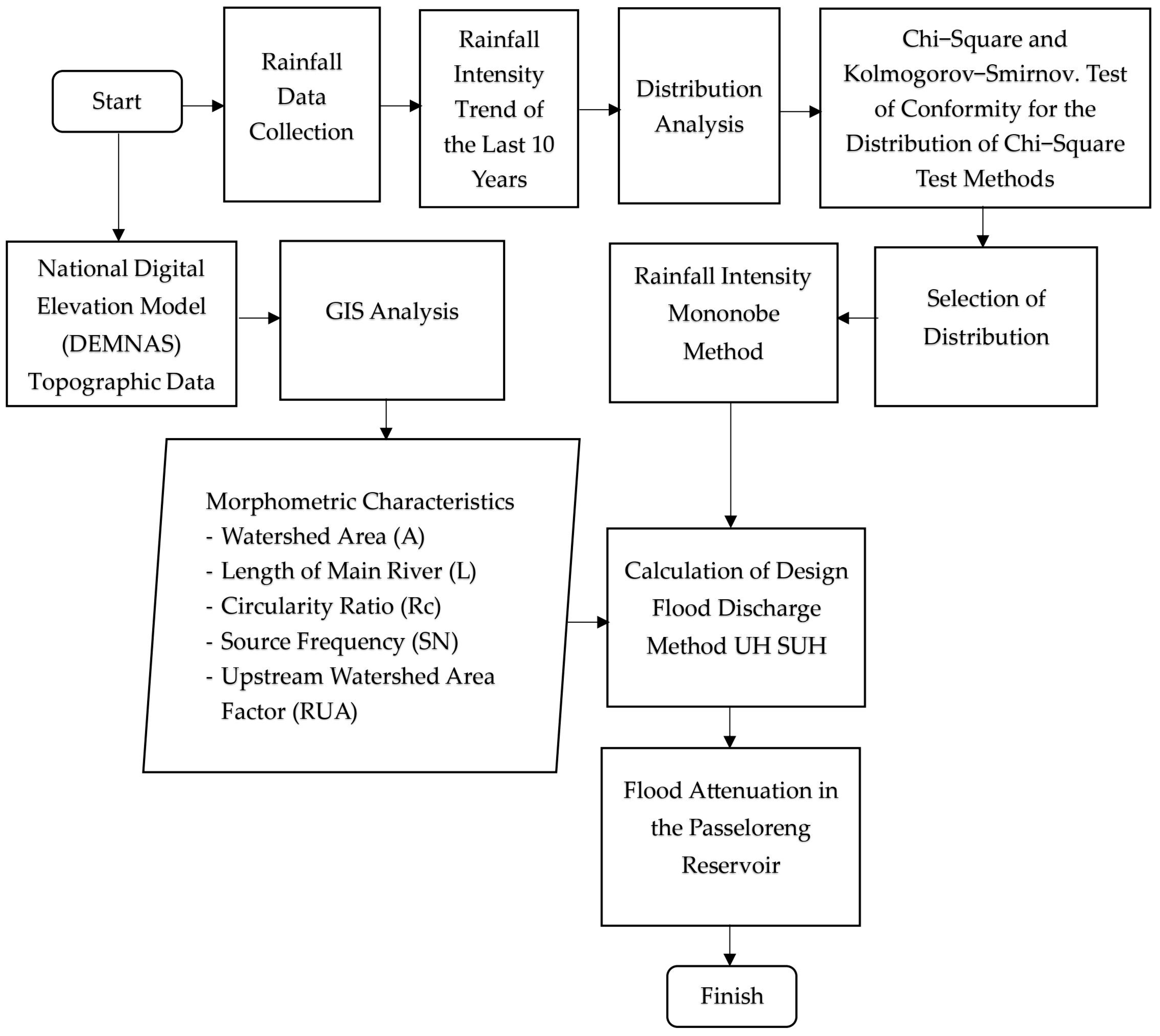
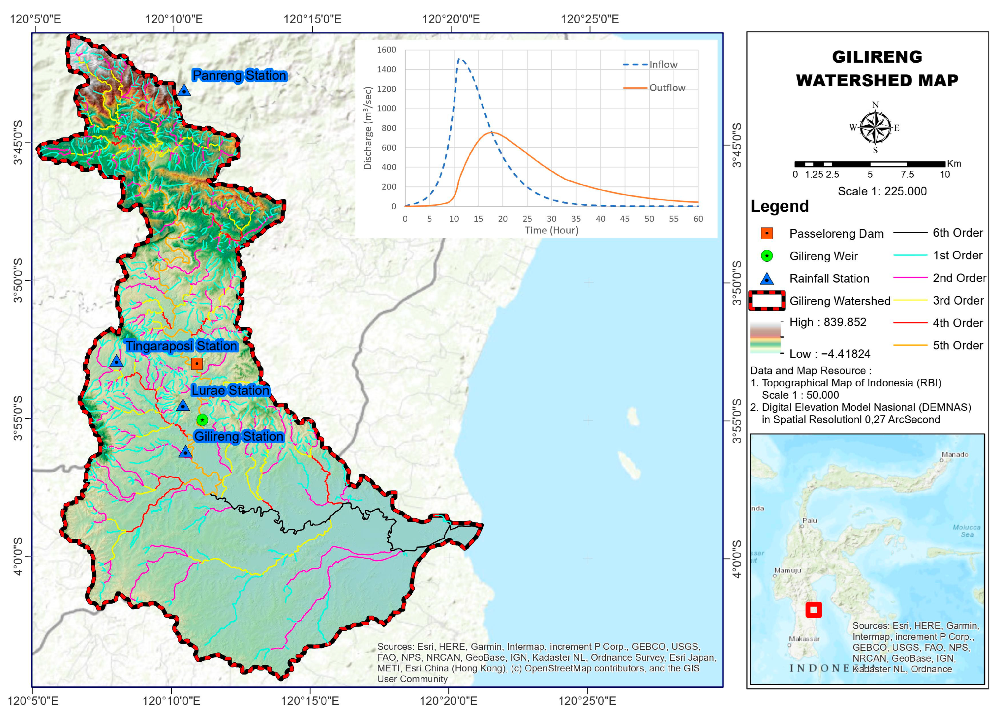
2.1. Flood Hydrology Analysis UH SUH Method
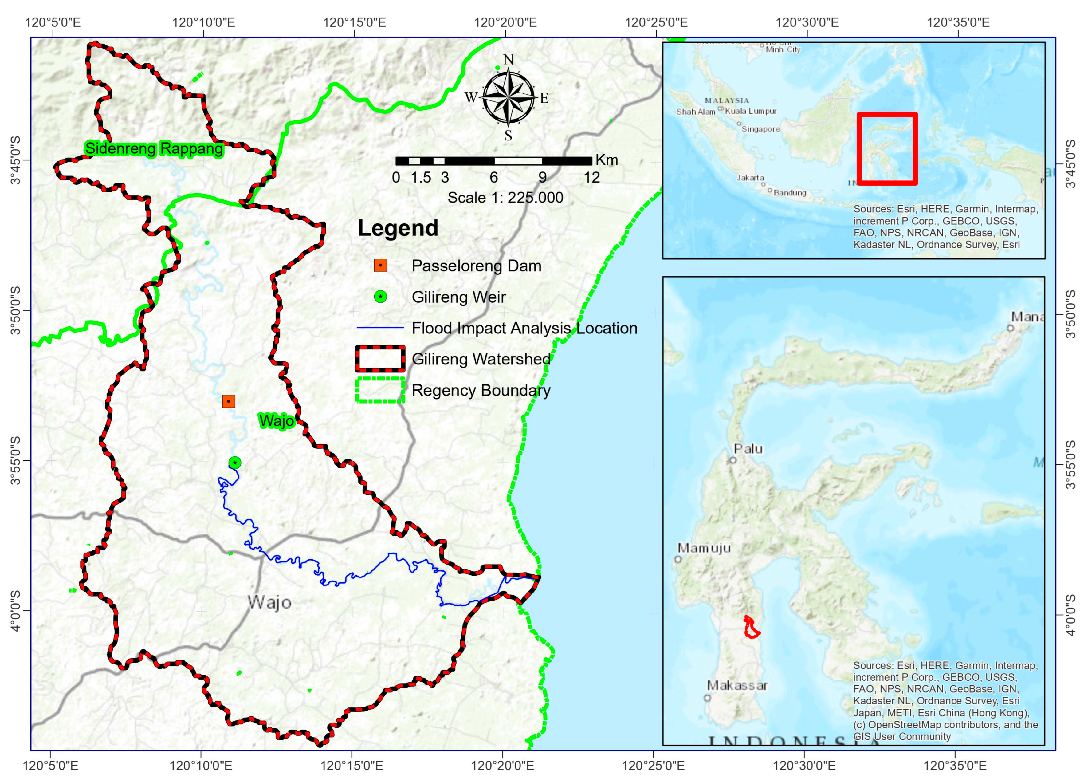
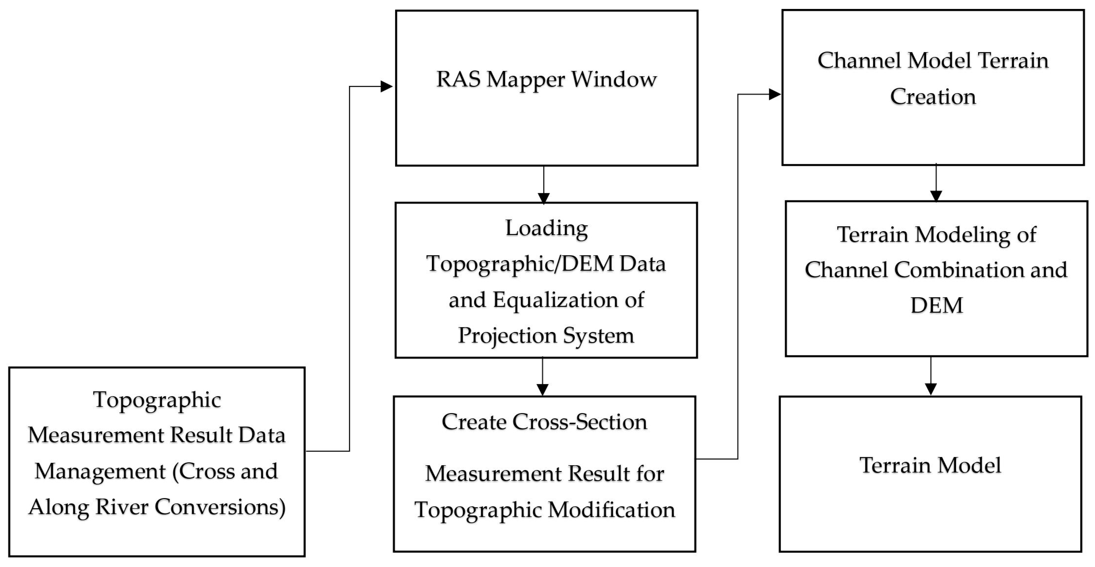
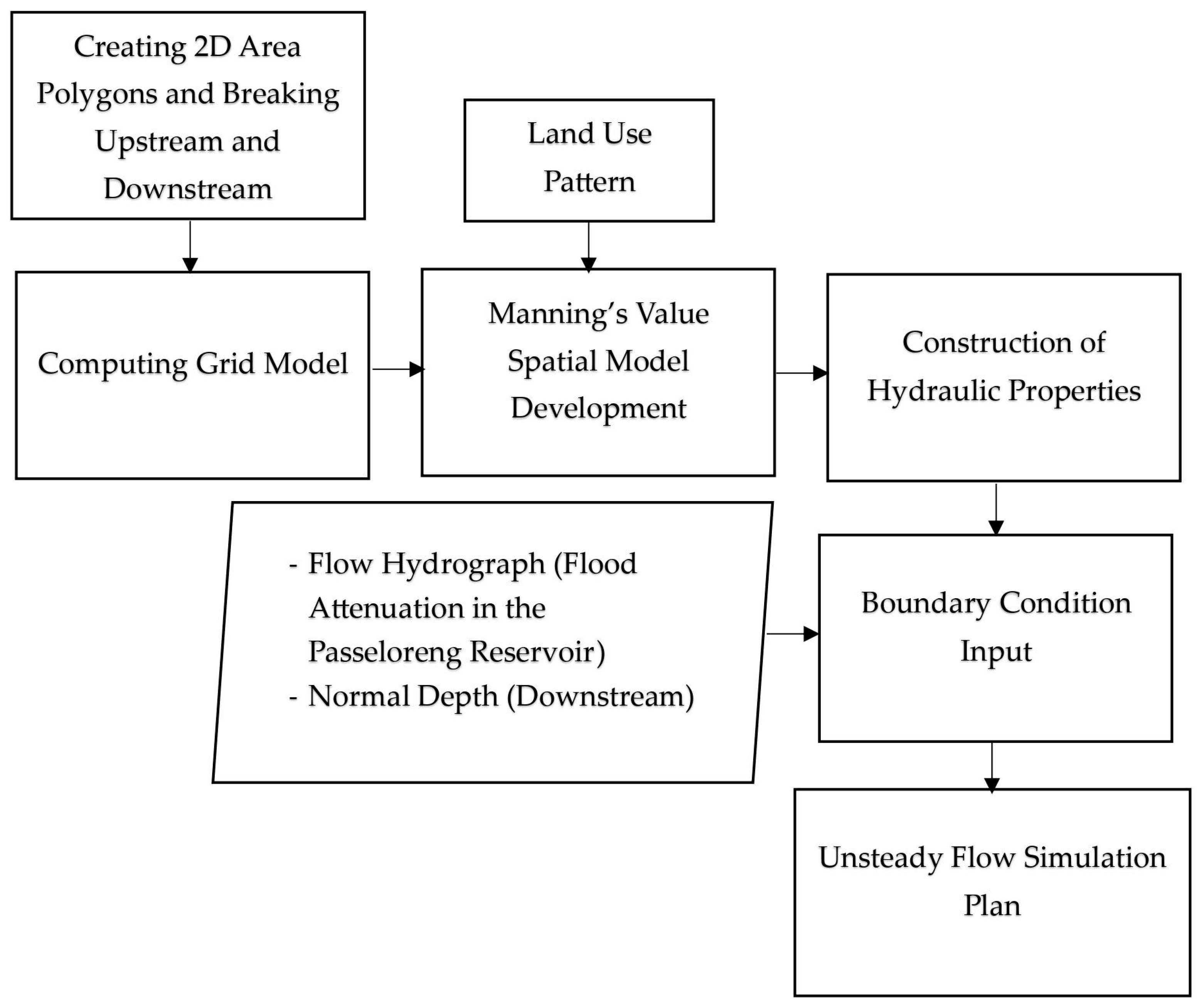
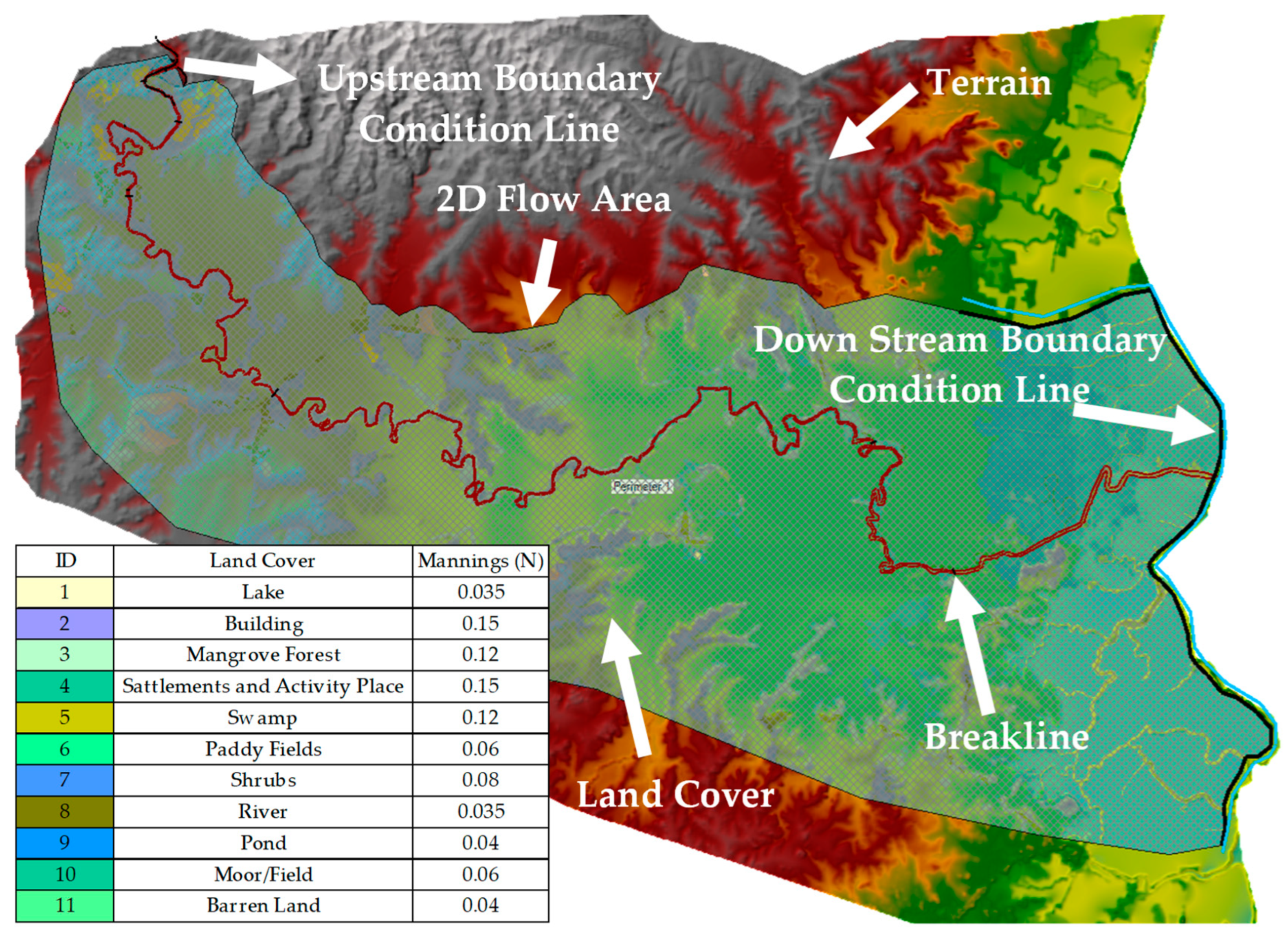
2.2. Flood Hydraulic Tracing Using 2D HEC-RAS Numerical Modeling
2.3. Spatial Modeling of Flood-Prone Areas
2.4. Flood Forecasting and Early Warning System
3. Results
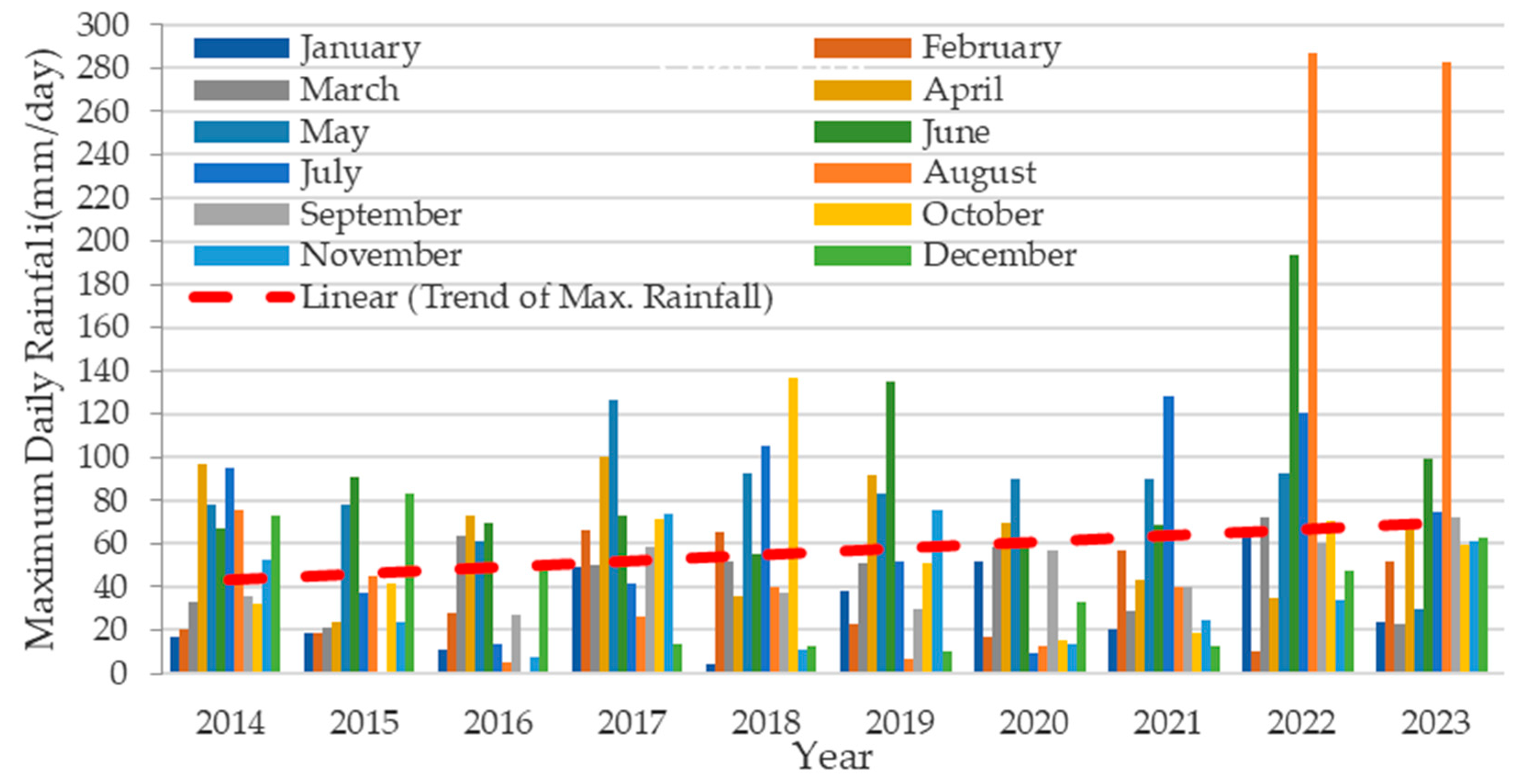
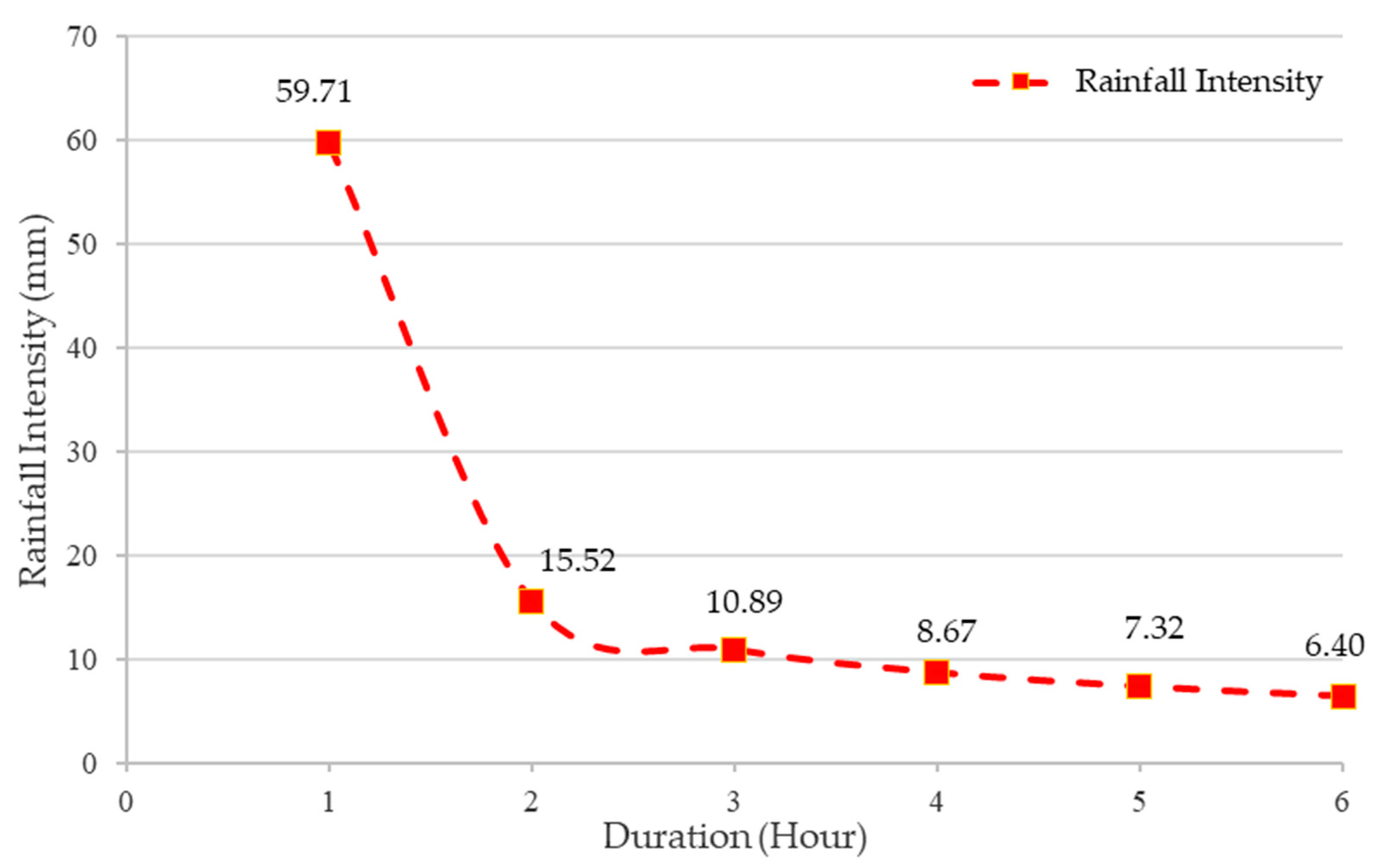
3.1. Flood Discharge Analysis
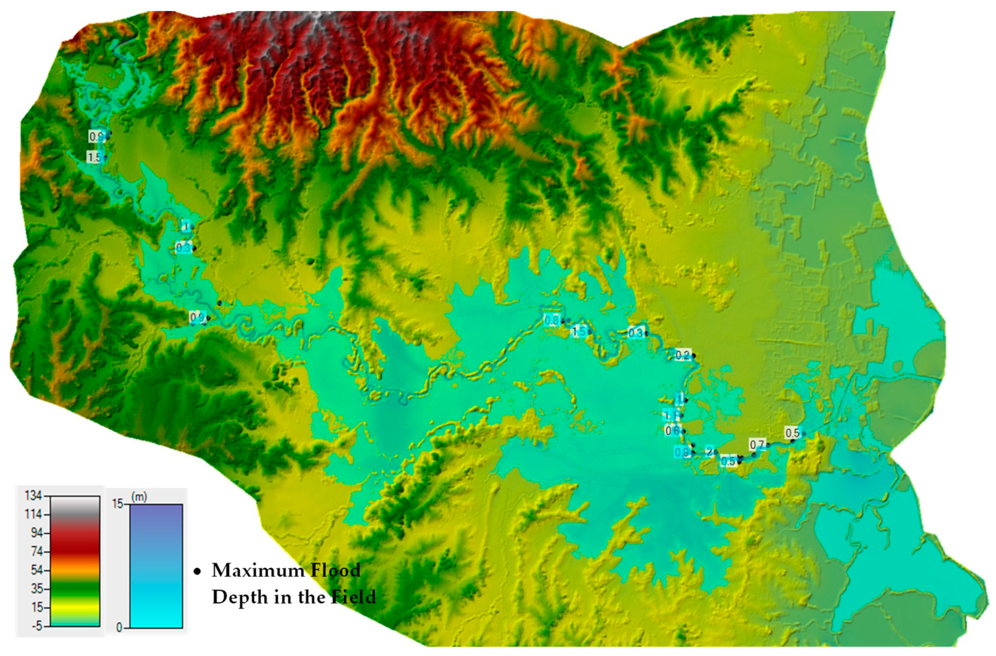
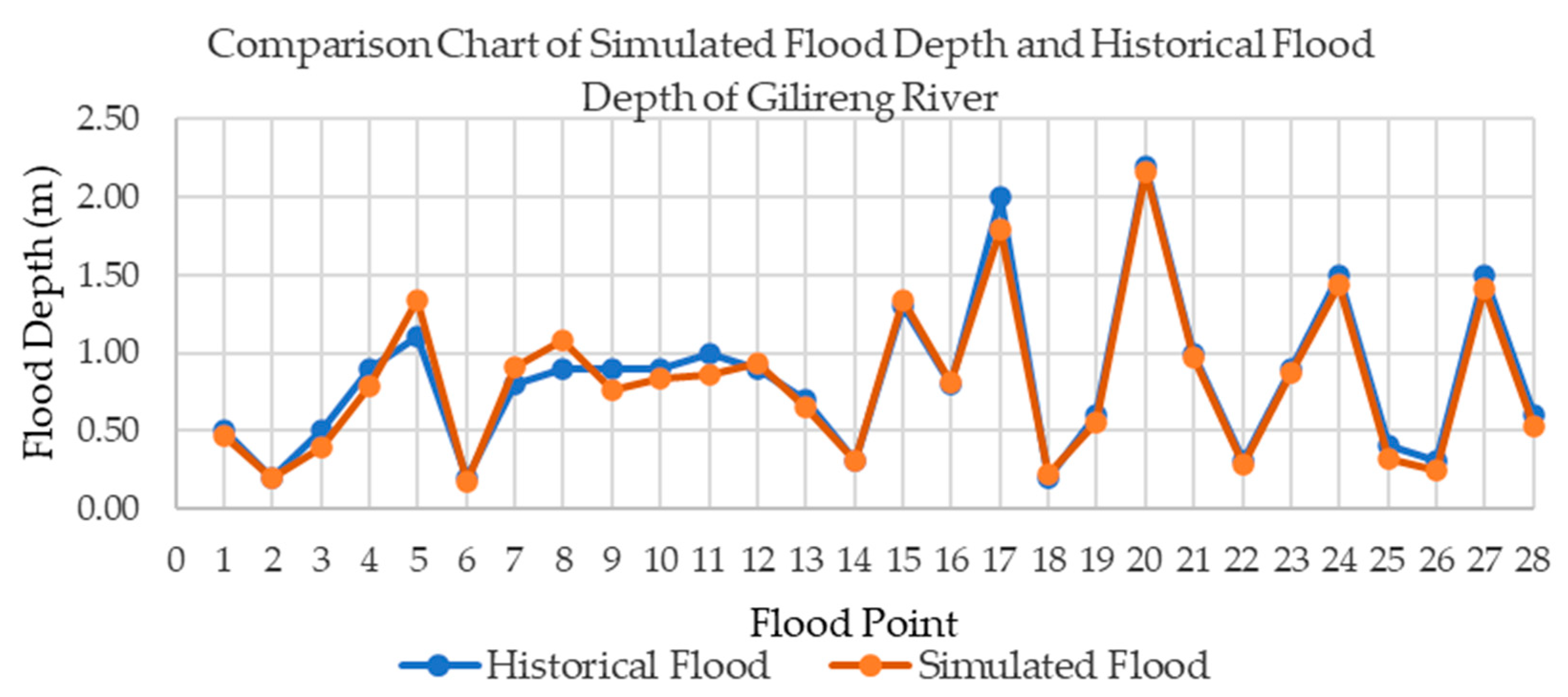
3.2. Flood Hydraulic Tracing
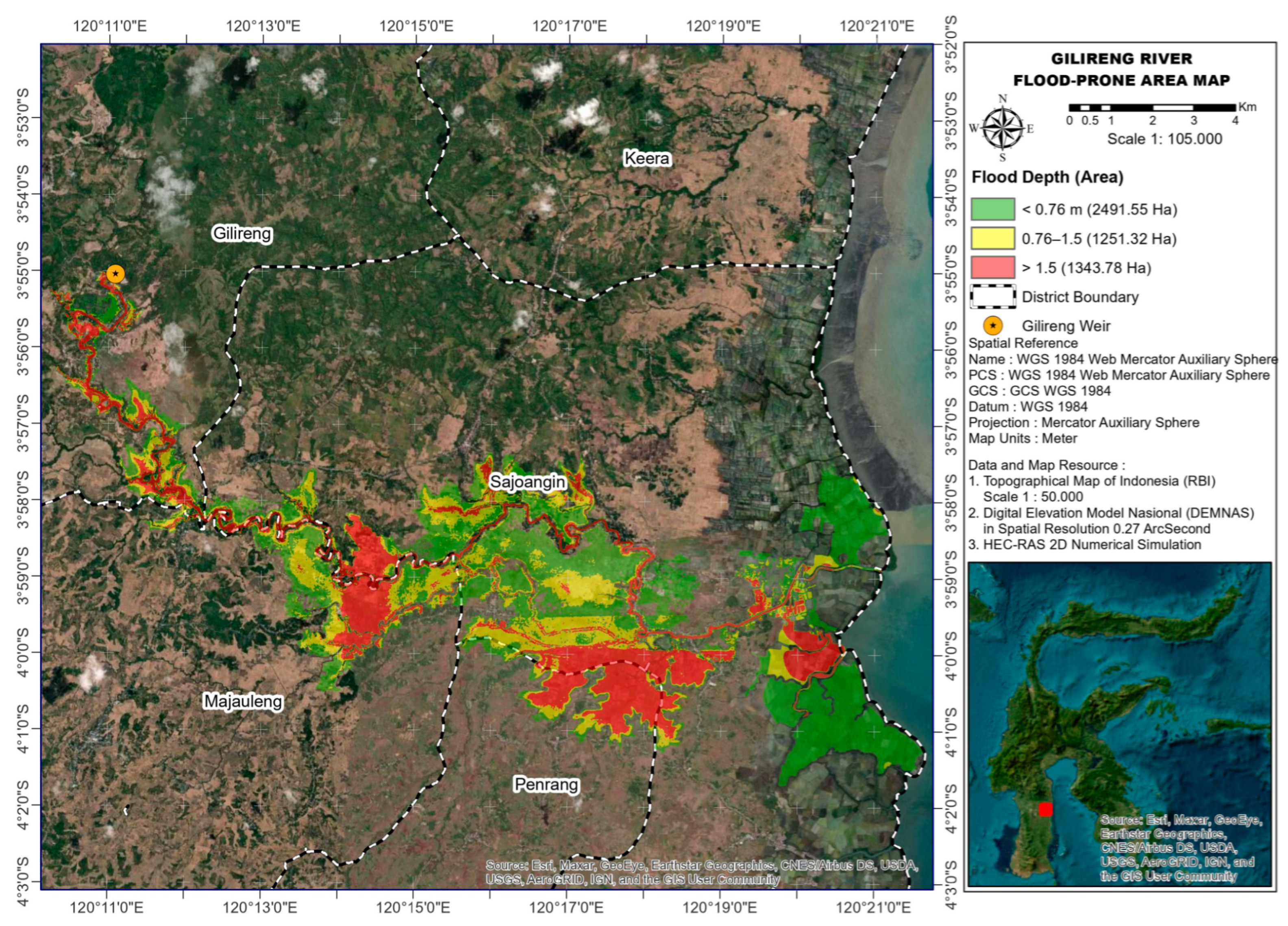
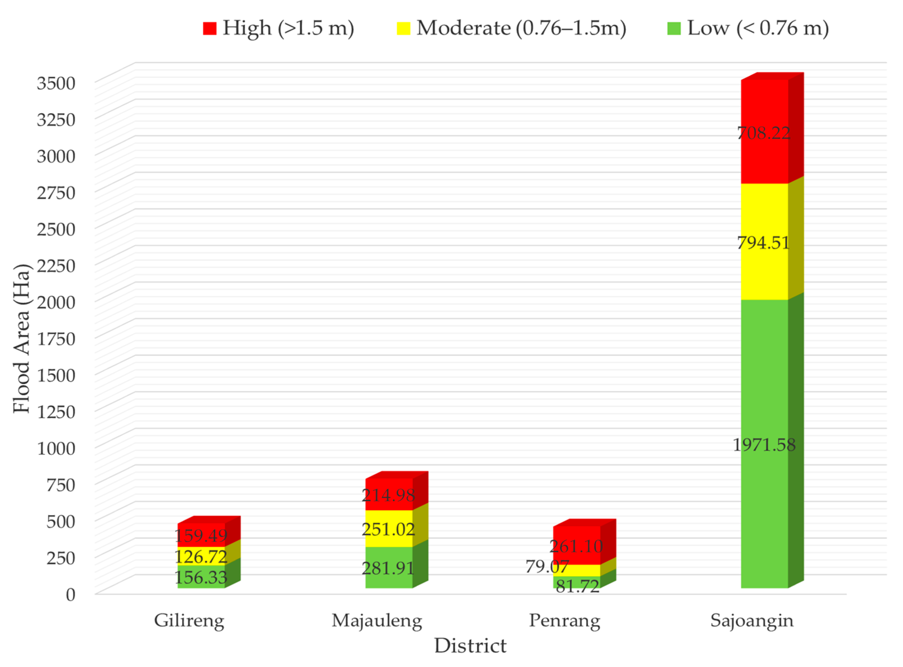
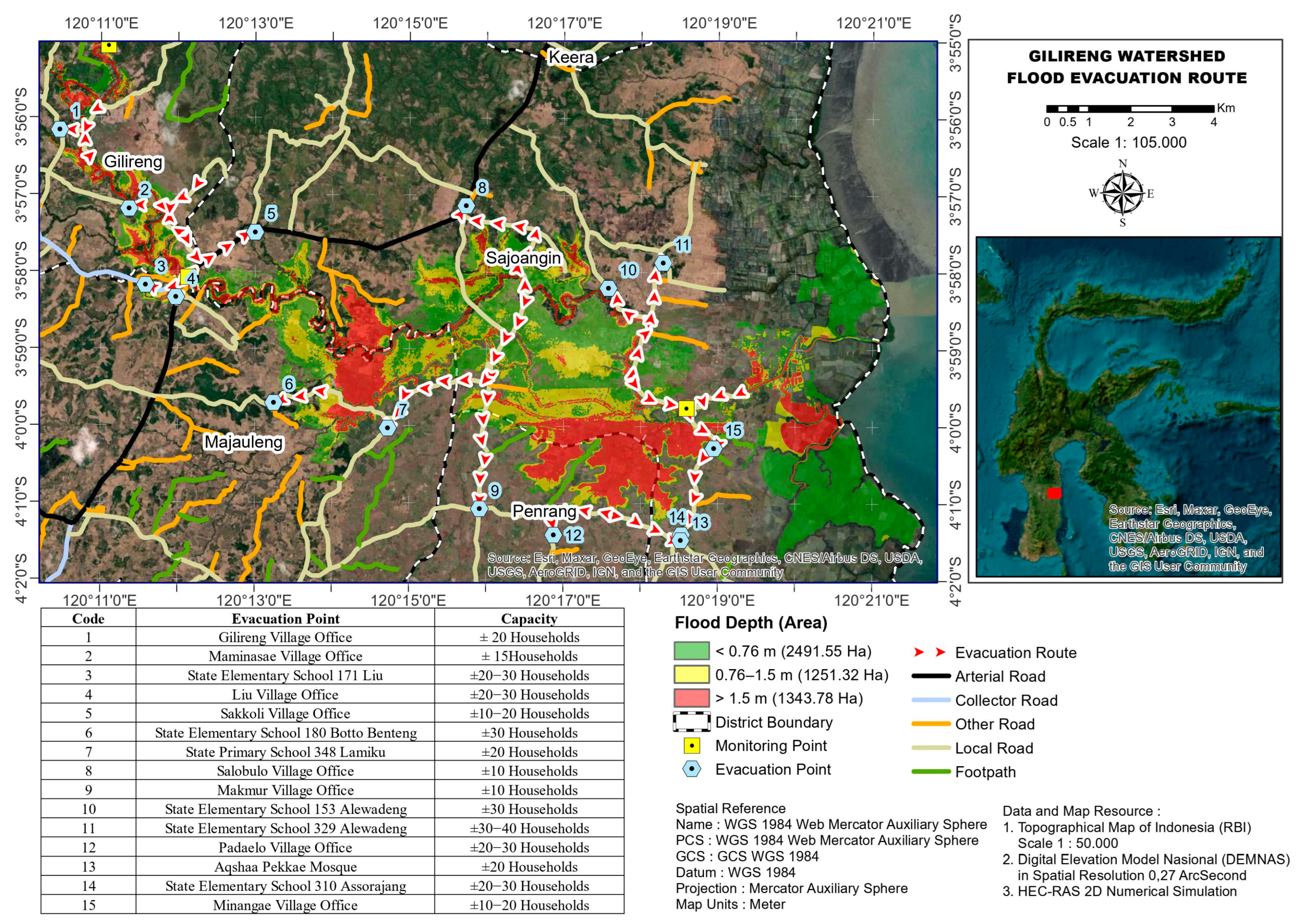
3.3. Spatial Model of Flood-Prone Areas
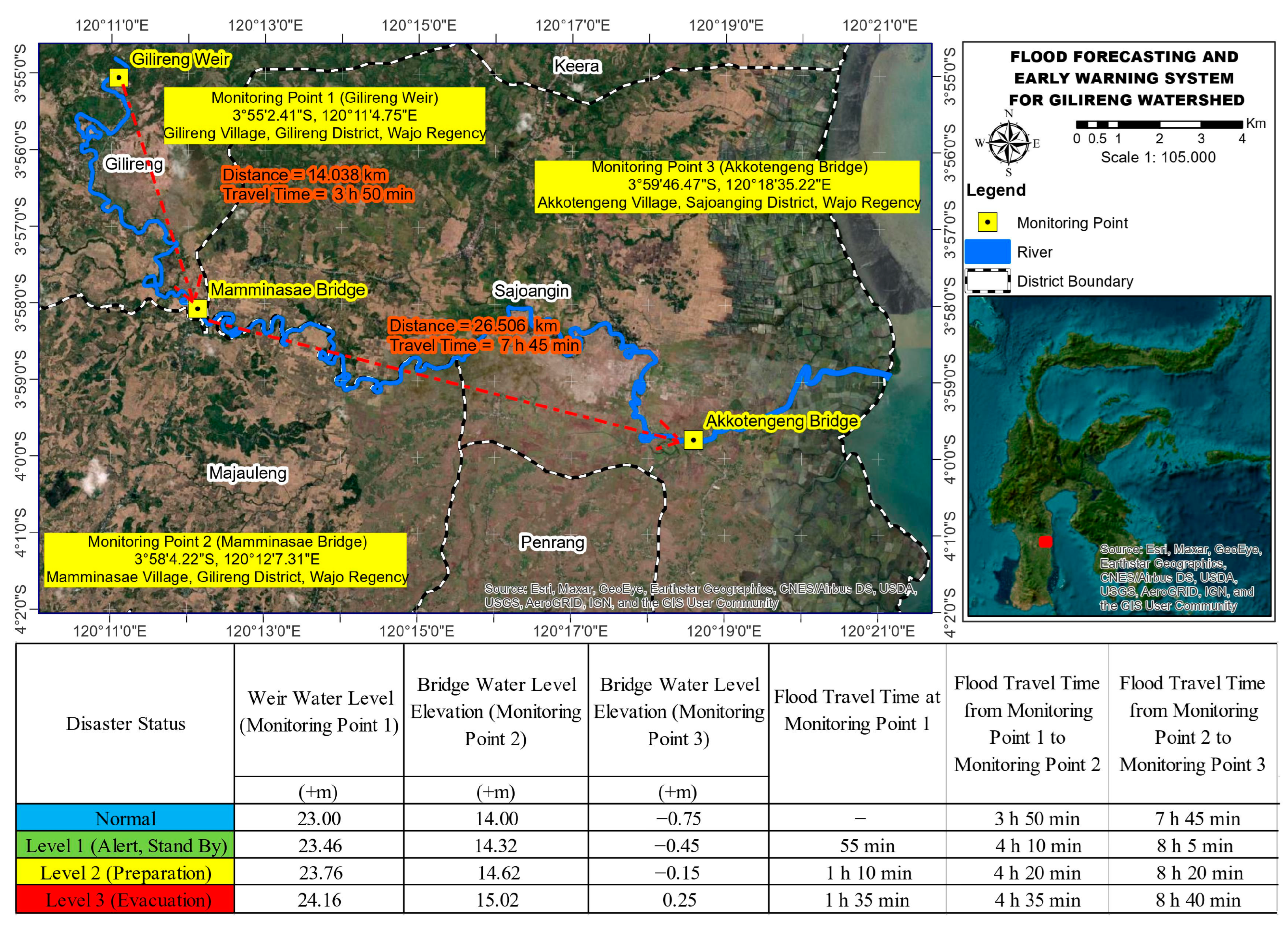
3.4. Flood Forecasting and Early Warning System
4. Discussion
5. Conclusions
Author Contributions
Funding
Data Availability Statement
Acknowledgments
Conflicts of Interest
References
- Fulazzaky, M. Challenges of Integrated Water Resources Management in Indonesia. Water 2014, 6, 2000–2020. [Google Scholar] [CrossRef]
- Asdak, C.; Yulizar; Subiyanto. A National Policy On Indonesia’s Integrated Water Resource Conservation Management. Indones. J. For. Res. 2023, 10, 151–162. [Google Scholar] [CrossRef]
- Ward, P.J.; de Ruiter, M.C.; Mård, J.; Schröter, K.; Van Loon, A.; Veldkamp, T.; von Uexkull, N.; Wanders, N.; AghaKouchak, A.; Arnbjerg-Nielsen, K.; et al. The Need to Integrate Flood and Drought Disaster Risk Reduction Strategies. Water Secur. 2020, 11, 100070. [Google Scholar] [CrossRef]
- Islam, R.; Kamaruddin, R.; Ahmad, S.A.; Jan, S.J.; Anuar, A.R. A Review on Mechanism of Flood Disaster Management in Asia. Int. Rev. Manag. Mark. 2016, 6, 29–52. [Google Scholar]
- Chai, J.; Wu, H.-Z. Prevention/Mitigation of Natural Disasters in Urban Areas. Smart Constr. Sustain. Cities 2023, 1, 4. [Google Scholar] [CrossRef]
- Yang, T.-H.; Liu, W.-C. A General Overview of the Risk-Reduction Strategies for Floods and Droughts. Sustainability 2020, 12, 2687. [Google Scholar] [CrossRef]
- Ramadhan, C.; Dina, R.; Nurjani, E. Spatial and Temporal Based Deforestation Proclivity Analysis on Flood Events With Applying Watershed Scale (Case Study: Lasolo Watershed in Southeast Sulawesi, Central Sulawesi, and South Sulawesi, Indonesia). Int. J. Disaster Risk Reduct. 2023, 93, 103745. [Google Scholar] [CrossRef]
- Mahmud, M.; Kusumandari, A.; Sudarmadji, S.; Supriyatno, N. A Study of Flood Causal Priority in Arui Watershed, Manokwari Regency, Indonesia. J. Manaj. Hutan Trop. 2018, 24, 81–94. [Google Scholar] [CrossRef]
- Mazalena, R.D.; Ahmad; Yusup, Y. Analysis of Run-off Potential for Flash Flood Management in Rahakolowu Watershed. IOP Conf. Ser. Earth Environ. Sci. 2022, 986, 012046. [Google Scholar] [CrossRef]
- Siregar, R.I.; Nursyamsi, N.; Indrawan, I. An Approach of Travel Time of Flood Peaks and Runoff Model towards Low Impact Development. Simetrikal J. Eng. Technol. 2020, 2, 1–12. [Google Scholar] [CrossRef]
- Kuller, M.; Schoenholzer, K.; Lienert, J. Creating Effective Flood Warnings: A Framework From a Critical Review. J. Hydrol. 2021, 602, 126708. [Google Scholar] [CrossRef]
- Lee, J.H.; Yuk, G.M.; Moon, H.T.; Moon, Y.-I. Integrated Flood Forecasting and Warning System against Flash Rainfall in the Small-Scaled Urban Stream. Atmosphere 2020, 11, 971. [Google Scholar] [CrossRef]
- Cole, S.J.; Moore, R.J.; Wells, S.C.; Mattingley, P.S. Real-Time Forecasts of Flood Hazard and Impact: Some UK Experiences. E3S Web Conf. 2016, 7, 18015. [Google Scholar] [CrossRef]
- Silvestro, F.; Rossi, L.; Campo, L.; Parodi, A.; Fiori, E.; Rudari, R.; Ferraris, L. Impact-Based Flash-Flood Forecasting System: Sensitivity to High Resolution Numerical Weather Prediction Systems and Soil Moisture. J. Hydrol. 2019, 572, 388–402. [Google Scholar] [CrossRef]
- Schroeder, A.J.; Gourley, J.J.; Hardy, J.; Henderson, J.J.; Parhi, P.; Rahmani, V.; Reed, K.A.; Schumacher, R.S.; Smith, B.K.; Taraldsen, M.J. The Development of a Flash Flood Severity Index. J. Hydrol. 2016, 541, 523–532. [Google Scholar] [CrossRef]
- Rosmadi, H.S.; Ahmed, M.F.; Bin Mokhtar, M.; Lim, C.K. Reviewing Challenges of Flood Risk Management in Malaysia. Water 2023, 15, 2390. [Google Scholar] [CrossRef]
- Syed Musa, S.M.S.; Md Noorani, M.S.; Abdul Razak, F.; Ismail, M.; Alias, M.A.; Hussain, S.I. An Early Warning System for Flood Detection Using Critical Slowing Down. Int. J. Environ. Res. Public Health 2020, 17, 6131. [Google Scholar] [CrossRef] [PubMed]
- Costabile, P.; Costanzo, C.; Kalogiros, J.; Bellos, V. Toward Street-Level Nowcasting of Flash Floods Impacts Based on HPC Hydrodynamic Modeling at the Watershed Scale and High-Resolution Weather Radar Data. Water Resour. Res. 2023, 59, e2023WR034599. [Google Scholar] [CrossRef]
- Kauffeldt, A.; Wetterhall, F.; Pappenberger, F.; Salamon, P.; Thielen, J. Technical Review of Large-Scale Hydrological Models For Implementation in Operational Flood Forecasting Schemes on Continental Level. Environ. Model. Softw. 2016, 75, 68–76. [Google Scholar] [CrossRef]
- Li, J.; Chen, Y.; Wang, H.; Qin, J.; Li, J.; Chiao, S. Extending Flood Forecasting Lead Time in a Large Watershed by Coupling WRF QPF With a Distributed Hydrological Model. Hydrol. Earth Syst. Sci. 2017, 21, 1279–1294. [Google Scholar] [CrossRef]
- Alqreai, F.N.; Altuwaijri, H.A. Hydrological Modeling and Evaluation of the Efficiency of Culverts in Drainage Basins Affecting the North Railway in Wadi Malham. Sustainability 2023, 15, 14489. [Google Scholar] [CrossRef]
- Sultan, D.; Tsunekawa, A.; Tsubo, M.; Haregeweyn, N.; Adgo, E.; Meshesha, D.T.; Fenta, A.A.; Ebabu, K.; Berihun, M.L.; Setargie, T.A. Evaluation of Lag Time and Time of Concentration Estimation Methods in Small Tropical Watersheds in Ethiopia. J. Hydrol. Reg. Stud. 2022, 40, 101025. [Google Scholar] [CrossRef]
- Mustamin, M.R. Synthetic Unit Hydrograph Modeling Based on Watershed Morphometry in South Sulawesi. Ph.D. Thesis, Hasanuddin University, Gowa, Indonesia, 2024. [Google Scholar]
- Ming, X.; Liang, Q.; Xia, X.; Li, D.; Fowler, H.J. Real-Time Flood Forecasting Based on a High-Performance 2-D Hydrodynamic Model and Numerical Weather Predictions. Water Resour. Res. 2020, 56, e2019WR025583. [Google Scholar] [CrossRef]
- Hou, J.; Han, H.; Li, Z.; Guo, K.; Qin, Y. Effects of Morphological Change On Fluvial Flood Patterns Evaluated By a Hydro-Geomorphological Model. J. Hydroinform. 2018, 20, 633–644. [Google Scholar] [CrossRef]
- Rak, G.; Kozelj, D.; Steinman, F. The Impact of Floodplain Land Use On Flood Wave Propagation. Nat. Hazards 2016, 83, 425–443. [Google Scholar] [CrossRef]
- Tsakiris, G. Flood Risk Assessment: Concepts, Modelling, Applications. Nat. Hazards Earth Syst. Sci. 2014, 14, 1361–1369. [Google Scholar] [CrossRef]
- Peker, İ.B.; Gülbaz, S.; Demir, V.; Orhan, O.; Beden, N. Integration of HEC-RAS and HEC-HMS with GIS in Flood Modeling and Flood Hazard Mapping. Sustainability 2024, 16, 1226. [Google Scholar] [CrossRef]
- Ezz, H. Integrating GIS and HEC-RAS to Model Assiut Plateau Runoff. Egypt. J. Remote Sens. Sp. Sci. 2018, 21, 219–227. [Google Scholar] [CrossRef]
- Yerramilli, S. A Hybrid Approach of Integrating HEC-RAS and GIS Towards the Identification and Assessment of Flood Risk Vulnerability in the City of Jackson, MS. Am. J. Geogr. Inf. Syst. 2012, 1, 7–16. [Google Scholar] [CrossRef]
- Azimah, M.N.; Adib, M.R.M.; Mustaffa, A.A. Integration of Hydraulic Model (HEC-RAS) With Geographical Information System (GIS) in Developing Flood Evacuation Center Along Sembrong River. IOP Conf. Ser. Earth Environ. Sci. 2019, 220, 012057. [Google Scholar] [CrossRef]
- Khaghan, A.; Mojaradi, B. The Integrate of HEC-HMS and HEC-RAS Models in GIS Integration Models to Simulate Flood (Case Study: The Area of Karaj). Curr. World Environ. 2016, 11, 1–5. [Google Scholar] [CrossRef][Green Version]
- Azouagh, A.; El Bardai, R.; Hilal, I.; Stitou el Messari, J. Integration of GIS and HEC-RAS in Floods Modeling of Martil River (Northern Morocco). Eur. Sci. J. ESJ 2018, 14, 130–142. [Google Scholar] [CrossRef]
- Sarsito, D.A.; Bramanto, B. Digital Elevation Model Alternatives Assessment for Deformation Analysis Purposes Using GNSS and INSAR. J. Meteorol. Dan Geofis. 2022, 23, 29–37. [Google Scholar] [CrossRef]
- Ziadat, F.M.; Taimeh, A.Y. Effect of Rainfall Intensity, Slope, Land Use and Antecedent Soil Moisture on Soil Erosion in an Arid Environment. Land Degrad. Dev. 2013, 24, 582–590. [Google Scholar] [CrossRef]
- Mustamin, M.R.; Maricar, F.; Karamma, R. Hydrological Analysis In Selecting Flood Discharge Method In Watershed Of Kelara River. INTEK J. Penelit. 2021, 8, 141–150. [Google Scholar] [CrossRef]
- Ruhiat, Y. Forecasting Rainfall and Potential for Repeated Events to Predict Flood Areas in Banten Province, Indonesia. J. Meas. Eng. 2022, 10, 68–80. [Google Scholar] [CrossRef]
- Faradiba. Analysis of Intensity, Duration, and Frequency Rain Daily of Java Island Using Mononobe Method. J. Phys. Conf. Ser. 2021, 1783, 012107. [Google Scholar] [CrossRef]
- Kusumastuti, C.; Sudjarwo, P.; Christhie, M.; Krisna, T. Intensity-Duration-Frequency (IDF) Curve and the Most Suitable Method to Determine Flood Peak Discharge in Upper Werba Sub-Watershed. Civ. Eng. Dimens. 2019, 21, 70–75. [Google Scholar] [CrossRef]
- Singh, P.K.; Mishra, S.K.; Jain, M.K. A Review of The Synthetic Unit Hydrograph: From The Empirical UH to Advanced Geomorphological Methods. Hydrol. Sci. J. 2014, 59, 239–261. [Google Scholar] [CrossRef]
- Tunas, I.G.; Anwar, N.; Lasminto, U. A Synthetic Unit Hydrograph Model Based on Fractal Characteristics of Watersheds. Int. J. River Basin Manag. 2019, 17, 465–477. [Google Scholar] [CrossRef]
- Zulfa, G.F.; Purnaditya, N.P.; Wigati, R.; Subekti, S.; Priyambodho, B.A. Prediction of Snyder Synthetic Unit Hydrograph Coefficient for Cidurian Watershed. Fondasi J. Tek. Sipil 2023, 12, 271–281. [Google Scholar] [CrossRef]
- Tunas, I.G.; Anwar, N.; Lasminto, U. Fractal Characteristic Analysis of Watershed as Variable of Synthetic Unit Hydrograph Model. Open Civ. Eng. J. 2016, 10, 706–718. [Google Scholar] [CrossRef]
- Tunas, I.G. The Application of ITS-2 Model for Flood Hydrograph Simulation in Large-Size Rainforest Watershed, Indonesia. J. Ecol. Eng. 2019, 20, 112–125. [Google Scholar] [CrossRef] [PubMed]
- Ozbey, N.; Gül, U.S. Constructing Uncertainty Budget for A Two-Dimensional Hydraulic Model. IOP Conf. Ser. Mater. Sci. Eng. 2019, 615, 012059. [Google Scholar] [CrossRef]
- Amaliah, R.; Ginting, B.M. Investigating the Capability of HEC-RAS Model for Tsunami Simulation. J. Civ. Eng. Forum 2023, 9, 161–180. [Google Scholar] [CrossRef]
- Bagheri, K.; Requieron, W.; Tavakol, H. A Comparative Study of 2-Dimensional Hydraulic Modeling Software, Case Study: Sorrento Valley, San Diego, California. J. Water Manag. Model. 2020, 28, C471. [Google Scholar] [CrossRef]
- Brunner, G.W. HEC-RAS, River Analysis System 2D Modeling User’s Manual Version 5.0; Hydrologic Engineering Center, Institute for Water Resources, US Army Corps of Engineers: Davis, CA, USA, 2016.
- Khair, U.; Fahmi, H.; Al Hakim, S.; Rahim, R. Forecasting Error Calculation with Mean Absolute Deviation and Mean Absolute Percentage Error. J. Phys. Conf. Ser. 2017, 930, 012002. [Google Scholar] [CrossRef]
- Amri, M.R.; Yulianti, G.; Yunus, R.; Wiguna, S.; Adi, A.W.; Ichwana, A.N.; Randongkir, R.E.; Septian, R.T. Risiko Bencana Indonesia (Indonesian Disaster Risk), 1st ed.; Jati, R., Amri, M.R., Eds.; Badan Nasional Penanggulangan Bencana: Jakarta, Indonesia, 2016.
- Maricar, F.; Karamma, R.; Mustamin, M.R.; Maricar, M.F. Numerical Simulation of Flood Propagation in the Kelara River Flood Early Warning System. J. Water Manag. Model. 2023, 31, C501. [Google Scholar] [CrossRef]

| Indicator Components | Depth (m) | Class |
|---|---|---|
| Map of Flood-prone areas | <0.76 | Low |
| 0.76–1.5 | Moderate | |
| >1.5 | High |
| Return Period (Year) | Rainfall Plan (mm) |
|---|---|
| 1.01 | 65.601 |
| 2 | 115.518 |
| 5 | 161.539 |
| 10 | 198.687 |
| 25 | 254.064 |
| 50 | 302.111 |
| 100 | 356.444 |
| No. | Morphometric Characteristics | Value |
|---|---|---|
| 1. | Watershed Area (A) | 513.61 km2 |
| 2. | Length Of Main River (L) | 100.81 km |
| 3. | Circularity Ratio (Rc) | 0.22 |
| 4. | Source Frequency (SN) | 0.74 |
| 5. | Upstream Watershed Area Factor (RUA) | 0.52 |
| No. | Coordinates | Historical Flood Depth (m) (A) | Simulated Flood Depth (m) (B) | Error (A–B) | MAPE | |
|---|---|---|---|---|---|---|
| Easting (m) | Northing (m) | |||||
| 1 | 202,775.58 | 9,558,338.80 | 0.50 | 0.47 | 0.03 | 0.07 |
| 2 | 202,531.48 | 9,558,186.71 | 0.20 | 0.19 | 0.01 | 0.04 |
| 3 | 201,294.37 | 9,557,760.99 | 0.50 | 0.39 | 0.11 | 0.21 |
| 4 | 200,236.83 | 9,557,936.65 | 0.90 | 0.78 | 0.12 | 0.13 |
| 5 | 199,971.44 | 9,558,711.29 | 1.10 | 1.33 | −0.23 | 0.21 |
| 6 | 200,247.89 | 9,559,961.76 | 0.20 | 0.17 | 0.03 | 0.16 |
| 7 | 197,255.02 | 9,560,678.27 | 0.80 | 0.91 | −0.11 | 0.13 |
| 8 | 189,129.15 | 9,560,737.03 | 0.90 | 1.08 | −0.18 | 0.20 |
| 9 | 189,038.14 | 9,560,630.61 | 0.90 | 0.76 | 0.14 | 0.15 |
| 10 | 188,783.83 | 9,560,622.25 | 0.90 | 0.83 | 0.07 | 0.08 |
| 11 | 188,760.47 | 9,562,625.03 | 1.00 | 0.86 | 0.14 | 0.14 |
| 12 | 186,829.48 | 9,564,484.95 | 0.90 | 0.93 | −0.03 | 0.03 |
| 13 | 201,952.43 | 9,558,101.19 | 0.70 | 0.65 | 0.05 | 0.07 |
| 14 | 201,631.27 | 9,557,888.82 | 0.30 | 0.31 | −0.01 | 0.02 |
| 15 | 201,362.29 | 9,557,828.37 | 1.30 | 1.34 | −0.04 | 0.03 |
| 16 | 201,252.51 | 9,557,846.68 | 0.80 | 0.82 | −0.02 | 0.02 |
| 17 | 200,762.64 | 9,557,950.15 | 2.00 | 1.79 | 0.21 | 0.11 |
| 18 | 200,253.24 | 9,558,117.62 | 0.20 | 0.22 | −0.02 | 0.08 |
| 19 | 200,019.64 | 9,558,379.36 | 0.60 | 0.55 | 0.05 | 0.09 |
| 20 | 199,914.14 | 9,558,449.88 | 2.20 | 2.16 | 0.04 | 0.02 |
| 21 | 200,065.77 | 9,559,040.17 | 1.00 | 0.97 | 0.03 | 0.03 |
| 22 | 199,171.16 | 9,560,409.07 | 0.30 | 0.29 | 0.01 | 0.05 |
| 23 | 197,387.93 | 9,560,689.23 | 0.90 | 0.87 | 0.03 | 0.04 |
| 24 | 197,874.72 | 9,560,452.94 | 1.50 | 1.44 | 0.06 | 0.04 |
| 25 | 189,389.30 | 9,561,041.98 | 0.40 | 0.32 | 0.08 | 0.20 |
| 26 | 188,805.18 | 9,562,183.30 | 0.30 | 0.24 | 0.06 | 0.20 |
| 27 | 186,785.42 | 9,564,053.65 | 1.50 | 1.41 | 0.09 | 0.06 |
| 28 | 186,878.43 | 9,564,582.61 | 0.60 | 0.52 | 0.08 | 0.13 |
| Amount | 2.74 | |||||
| Overall Mean Absolute Percentage Error (MAPE) (%) | 9.79 | |||||
Disclaimer/Publisher’s Note: The statements, opinions and data contained in all publications are solely those of the individual author(s) and contributor(s) and not of MDPI and/or the editor(s). MDPI and/or the editor(s) disclaim responsibility for any injury to people or property resulting from any ideas, methods, instructions or products referred to in the content. |
© 2024 by the authors. Licensee MDPI, Basel, Switzerland. This article is an open access article distributed under the terms and conditions of the Creative Commons Attribution (CC BY) license (https://creativecommons.org/licenses/by/4.0/).
Share and Cite
Mustamin, M.R.; Maricar, F.; Lopa, R.T.; Karamma, R. Integration of UH SUH, HEC-RAS, and GIS in Flood Mitigation with Flood Forecasting and Early Warning System for Gilireng Watershed, Indonesia. Earth 2024, 5, 274-292. https://doi.org/10.3390/earth5030015
Mustamin MR, Maricar F, Lopa RT, Karamma R. Integration of UH SUH, HEC-RAS, and GIS in Flood Mitigation with Flood Forecasting and Early Warning System for Gilireng Watershed, Indonesia. Earth. 2024; 5(3):274-292. https://doi.org/10.3390/earth5030015
Chicago/Turabian StyleMustamin, Muhammad Rifaldi, Farouk Maricar, Rita Tahir Lopa, and Riswal Karamma. 2024. "Integration of UH SUH, HEC-RAS, and GIS in Flood Mitigation with Flood Forecasting and Early Warning System for Gilireng Watershed, Indonesia" Earth 5, no. 3: 274-292. https://doi.org/10.3390/earth5030015
APA StyleMustamin, M. R., Maricar, F., Lopa, R. T., & Karamma, R. (2024). Integration of UH SUH, HEC-RAS, and GIS in Flood Mitigation with Flood Forecasting and Early Warning System for Gilireng Watershed, Indonesia. Earth, 5(3), 274-292. https://doi.org/10.3390/earth5030015


