Abstract
Water-regulating ecosystem services (ESs) are a key factor in water supply for the population and the economy. In recent years, these ESs have been intensively included in regional and global assessments. However, the degree of knowledge of various water-regulating ESs and the availability of models for their estimation and mapping vary greatly. For example, most regional assessments currently do not take into account the ESs of moisture and precipitation recycling by forests which can lead to erroneous decisions on land use and forest management. To what extent is it possible to make adequate decisions on the basis of a partial assessment of the ESs? In this article, we discuss this problem using the example of boreal forests in the catchment of the Lake Kenozero in the north of the European part of Russia. Using the InVEST model, two ESs were quantified and mapped: water yield regulation due to evapotranspiration and water quality assurance due to prevention of soil erosion. The reduction in water yield due to evapotranspiration was estimated at 125 mm/year, and the prevention of soil erosion was estimated at 9.56 t/ha/year. Forest felling in the study area from 2007 to 2021 led to an increase in runoff and soil erosion by 6 mm/year and 0.03 t/ha/year, respectively. The hypothetical total instantaneous forest loss could lead to an increase in runoff and soil erosion by 71 mm/year and 2.44 t/ha/year, respectively. A tradeoff between these ESs was predictably identified as deforestation led to an increase in water yield and a deterioration in water quality due to soil erosion. The significance of a number of other water-regulating ESs for making regional decisions was expertly assessed. In particular, the importance of the ESs of precipitation recycling of sludge under climate change was discussed. Expanding the range of ESs under consideration increases the likelihood of choosing a protection strategy instead of a harvesting one in forest management.
1. Introduction
Ensuring water security is one of the main goals for mankind under the current global change. It has been proclaimed as Sustainable Development Goal 6: “Ensure availability and sustainable management of water and sanitation for all”. Achieving this goal requires the accounting, maintenance, and effective management of water-regulating ecosystem services (ESs) and the application of relevant nature-based solutions [1,2].
Vegetation performs a wide range of ESs related to water quality, quantity, and timing, namely, ensuring runoff quality, retaining soil, sediments, and nutrients, stabilizing runoff, buffering peak river flows, supporting dry-season flow, preventing floods, and recharging groundwater. The critical role of vegetation, especially forests, in preventing soil erosion and ensuring water quality is considered a key component of environmentally responsible land use and forest management, on which large-scale reforestation projects are based in many regions of the world [3,4,5].
However, water-regulating ESs are studied to a very different extent and cannot be assessed equally accurately to create an information basis for regional decision making. For example, popular in recent years, the InVEST model [6,7,8,9,10,11,12,13,14] evaluates three water-regulating ESs: (a) regulation of water yield due to evapotranspiration, (b) separation of runoff into surface runoff and baseflow, and (c) preventing soil and nutrients from being washed into water bodies. Evaluation of other water-related ESs requires professional modeling, which is not available for wide use in regional and local decision making.
Forests are considered the most important terrestrial ecosystems for water management. The positive role of forests is shown for most water-regulating ESs. However, the influence of forest on water availability remains debatable. The so-called “demand-side” scientific school emphasizes that forests are net users of water within a catchment and decrease water yield. Numerous paired catchment studies showed that forest increases evapotranspiration and decreases river streamflow [15,16,17]. Scholars of the “supply-side” school argue that forests can improve water availability, being a source of downwind precipitation and rather “recyclers” and “redistributors” than “consumers” of water [2,3,4,5,16].
Globally, 20–50% of precipitation over land evaporates from land. Vast inland regions rely heavily on terrestrially recycled moisture, receiving from one-third to four-fifths precipitation from this ecosystem function [16,18,19,20]. Analysis of satellite remote-sensing data confirmed for the tropics that air that has passed over extensive vegetation in the preceding few days produces at least twice as much rain as air that has passed over little vegetation [21]. Thus, vegetation’s influence on the recycling of air moisture and precipitation should be considered an essential ES and included in land and forest management [4,16,18]. These ESs work on regional, continental (see, e.g., [22]), and even intercontinental scales [3,23]. The net effect of this ES varies greatly regionally, and large-scale reforestation can increase water availability in some regions, while decreasing it in others [24]. These effects are studied mainly globally or in tropical regions, while there is a knowledge gap for temperate regions [25]. Despite its importance in the face of climate change, this ES is generally not included in regional assessments, and there are currently no publicly available models for its assessment.
Different possibilities for evaluating different ESs can lead to a bias in favor of easier-to-estimate ESs, while difficult-to-estimate ESs can be underestimated. Such biases in ES assessment can lead to management errors [4,5]. Another difficulty for decision making is in the tradeoffs between different ES, when strengthening of one ES leads to weakening of the other. Among water-regulating ESs, the tradeoff is usually found between water yield and water quality [3,5].
The purpose of this article was to compare the management interpretation of a partial ES assessment by two water-regulating ESs (i.e., ensuring yield and quality of water) with assessment of a wider ES range using the watershed of Lake Kenozero as an example. The tested and discussed hypotheses were as follows: (a) the presence of a tradeoff between the ESs of ensuring water yield and water quality; (b) increasing the likelihood of choosing a conservation strategy instead of harvesting one in forest management.
We first present the results of the physical evaluation of two ESs estimated and mapped by the InVEST model, i.e., water yield regulation and prevention of soil drift into water bodies. We then discuss the importance of other water-regulating ESs which were not quantified for the study area. Subsequently, we analyze tradeoffs and synergies among different water-regulating ESs, as well as their possible managerial interpretations. Lastly, we provide short recommendations on how biases in decision making can be reduced when it is not possible to equally and accurately assess the entire set of water-regulating ESs.
This study was conducted within the framework of the joint project of the Kenozero National Park [26] and TEEB-Russia (http://teeb.biodiversity.ru/en/, accessed on 19 October 2022) on the assessment of biodiversity and ecosystem services.
2. Materials and Methods
2.1. Study Area
The study area was located in the northern moraine part of the Russian Plain, within Fennoscandia (territory center coordinates 62°15′ N, 38°15′ E). It belongs to the Dfc climate type (continental boreal climate with cold summer and without dry season) according to the Koppen–Geiger classification scheme. The climate is formed by the influence of the Arctic seas and intensive transfer of atmospheric masses from the west. The average annual air temperature is about +2 °C. The average duration of the frost-free period is 108 days. Snow cover usually appears in October, lasts 175 days on average, and melts until 1 May. The growing season lasts from May to October. The average annual precipitation is 605 mm/year. The minimum precipitation falls in February, while the maximum falls in June–September.
The study area includes the catchment of Lake Kenozero (620,000 ha) belonging to the White Sea basin and the territory of Kenozero National Park (Figure 1). The catchment of Lake Kenozero includes most of the territory of the national park (140,000 ha). Two areas in the southern part of the park belong to the basin of Lake Lache (White Sea basin) and the basin of the Baltic Sea. The Maselga watershed ridge between the basins of the Atlantic and Arctic oceans is a unique geographic object. From it, two lakes belonging to the basins of different oceans are visible.
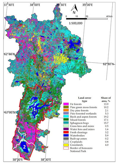
Figure 1.
Study area: land-cover types and their area share in 2021; 1—the catchment of Lake Kenozero; 2—the catchment of Lake Lache; 3—the catchment of Baltic Sea.
The relief is flat with pronounced fluvioglacial forms: elongated ridges, rounded hills, and outwash plains. The ancient crystalline foundation is covered with thick layers of poorly permeable sedimentary rocks. Slow runoff processes in the flat area and a shallow groundwater table have led to the development of swamps. The largest bog massifs are located in extensive depressions with glacial sandy and sandy loam deposits.
The study area is located in the zone of boreal forests of middle taiga. Forests and swamps together occupy 90% of the area (Figure 1) and are typical for the subzones of the northern and middle taiga of the European part of Russia. Spruce forests are the primary zonal formation. Pine forests are also common. Deciduous and mixed forests are located in areas that were previously used for agriculture or were cut down for timber. Furthermore, 6% of the area is occupied by water bodies. Few grasslands (less than 0.1%) are of predominantly anthropogenic origin.
Soils of podzolic, bog–podzolic, bog types are common in the territory. Gley–podzolic soils lie under spruce forests. Typical podzolic soils are common on hillsides in well-drained watersheds under coniferous forests. Illuvial–humus and ferruginous podzols are developed on sands under lichen pine forests. More fertile soddy–podzolic soils are typical in well-drained areas under deciduous and mixed forests. Poor waterlogged bog–podzolic soils (peaty–podzolic) are common on flat poorly drained loam watersheds, under spruce or spruce–pine forests. Bog soils are developed in low areas with constantly excessive moisture.
Currently, the territory is little developed by humankind. Built-up areas and arable land together occupy about 1% of the area. Agriculture is almost undeveloped and is concentrated on small plots near settlements. However, in the past, until the middle of the 20th century, the southern part of the territory in the vicinity of Lake Kenozero was densely populated and converted to agriculture. Forest ecosystems there have been heavily transformed and currently are mainly represented by secondary forests. In 1991, Kenozero National Park was formed to preserve cultural landscapes, as well as natural ecosystems and biodiversity. Outside the park, forest logging was carried out in Soviet times and continues today. Currently, unforested fresh clearcuts occupy about 3% of the area.
2.2. Land Cover and Topography Data and Their Processing
A digital land-cover map of the Arkhangelsk region with 30 m resolution for 2007 was used [27,28]. We updated the 2007 map for 2021 (Figure 1) according to the following algorithm: (1) clearings that existed in 2007 were transferred to the category “deciduous forests”; (2) clearings that were made from 2007 to 2019 were determined from Global Forest Watch [29,30] and were transferred to the category “grasslands”; (3) clearings that were made from 2019 to 2021 were determined from the same source and were transferred to the category “bare ground”. The catchment area was determined by database of elementary catchments of the first order of the Kazan Federal University [31]. The boundaries of the national park were obtained from the Open Street Map for the Arkhangelsk region [32]. A digital elevation model of 30 m resolution was obtained by merging a mosaic of two raster datasets of a digital elevation model from the company NextGIS (Harjumaa, Estonia, https://nextgis.ru/, 19 October 2022). Calculations were made in ArcGIS 10.5 software.
All the above- and below-mentioned raster spatial datasets used in this study were reprojected into the WGS 84/UTM zone 37 N projection and resampled to a minimum spatial resolution equal to the size of one pixel of the vegetation map (i.e., 30 m). The calculations were carried out in the ArcGIS 10.5 software.
2.3. Estimating and Mapping Ecosystem Services
Two ESs were estimated and mapped using the InVEST model: water yield regulation and the prevention of soil flushing into water bodies. ESs were estimated for the following five variants of land cover: (A) vegetation in 2007; (B) vegetation in 2021; (C) bare ground throughout the territory, except for water bodies; (D) bare ground instead of all forests as an imitation of simultaneous total forest loss; (E) grasslands instead of all forests as an imitation of grass overgrowing of total clearings in three years. The following indicators were determined as differences between ES provided by different land covers:
- -
- ESs provided by current vegetation were estimated as difference between ESs in 2021 and ESs provided by only bare ground (land cover C);
- -
- The loss of ES due to forest felling after 2007 was estimated as the difference between ESs in 2021 and ESs in 2007;
- -
- The loss of ES due to hypothetical instant total forest felling was estimated as the difference between ESs in 2021 and ESs provided by bare ground instead of all forests and other land-cover types (landcover D);
- -
- The initial dynamics of ES recovery after total forest felling was estimated as the difference between ESs provided by landcover D and landcover E.
The ES of water yield regulation was estimated and mapped using the “Annual Water Yield” module of InVEST. The annual water yield Y(x) was calculated as the difference between the precipitation in the study area and the actual evapotranspiration using Equation (1)
where P(x) is the annual precipitation and AET(x) is the annual actual evapotranspiration in pixel x.
Y(x) = P(x) − AET(x),
For built-up areas and wetlands, AET was calculated directly from the reference evapotranspiration ET0(x) and has an upper limit determined by precipitation:
where PET(x) is the potential evapotranspiration, ET0(x) is the reference evapotranspiration, P(x) is the annual precipitation in pixel x, and Kc(lx) is the evapotranspiration coefficient for each land-cover type.
AET(x) = Min (PET(x), P(x)) = Min (Kc(lx)ET0(x), P(x)),
For vegetation, the formulas for AET were as follows:
where N(x) is the number of rain events per year, PAWC(x) is the plant available water content, and h(x) is the root bounding layer depth, defined as follows:
h(x) = Min (Root restricting layer depth; Root depth).
The following parameters were used for ES calculation and mapping:
- -
- Average annual precipitation from WorldClim global dataset [33] expressed in mm/year.
- -
- Average annual reference evapotranspiration ET0 from Global Aridity and PET Database, CGIAR [34]. Alfalfa or sward was considered as a reference vegetation cover. On the basis of ET0, the potential evapotranspiration PET of each land-cover type was calculated using the evapotranspiration coefficient Kc (see below).
- -
- Root restricting layer depth from the Harmonized World Soil Database (HWSD) [35]. The “roots” field was used, which expresses the presence of obstacles to the roots at various depths of the soil profile. We used the average values for the depth of obstacles for the roots: class 1—800 mm, class 2—700 mm, class 3—500 mm, class 4—300 mm, class 5—200 mm, and class 6—100 mm.
- -
- Plant available water content (PAWC) calculated in SPAW (Soil–Plant–Air–Water) software based on soil texture data (texture class, the percentage of sand and clay) from HWSD.
- -
- Root depth containing 90% of root biomass according to [36]. This value was 1500 mm for taiga forests and 100 mm for herbaceous communities (i.e., grasslands and croplands on the land-cover map of the study area).
- -
- The evapotranspiration coefficient (Kc) for all forest types was set as 1.0, for croplands and grasslands was set as 0.67, for sphagnum bogs was set as 1.0, for sedge and grass bogs was set as 1.1, for wet swamps and bogs was set as 1.2, for bare ground and fresh clearings was set as 0.50, and for built-up areas was set as 0.56.
- -
- The coefficient for forests was calculated on the basis of the leaf area index (LAI) for the growing season according to 300 m resolution data of the European Union Earth Observation Program Copernicus [37]. LAI values exceeding 3.0, which is typical for forests on study area, were equated to Kc = 1.0 in the InVest model.
- -
- In the study area, areas defined as croplands on the land-cover map were represented by perennial grasses; therefore, the same value of Kc (clover hay, averaged cutting effects) was used for grasslands and croplands from the FAO Guidelines for computing crop water requirements [38].
- -
- The growing season was considered from May to October [39]. The beginning of the initial stage was determined from the average date of the resumption of the vegetation of winter rye and the date of transition of the average daily air temperature through 5 °C. In both cases, this date was 30 April. The initial stage fell in May and June. The beginning of the middle stage, i.e., full summer, was determined from the date of earring of spring wheat (15 July) and the date of blueberry ripening (25 July). This stage fell in July and August. The end stage began when the air temperature passed through 10 °C (5 September), i.e., it fell in September and October.
- -
- Kc values for wetlands were determined on the basis of the principle that a more water-saturated ecosystem has a greater value. InVest suggests that Kc for wetlands can be assumed in the range of 1.0 to 1.2. Therefore, we used the value 1.0 for sphagnum bogs, 1.1 for sedge and grass bogs, and 1.2 for wet swamps and bogs.
- -
- Fresh clearcuts (less than 3 years) were merged into one class with bare ground, because destroyed vegetation in the middle taiga recovers slowly.
- -
- In accordance with InVest, Kc for built-up areas was calculated as Kc = 0.1f + 0.6(1 – f), where f is the fraction of impervious surface in the area. There are no paved roads in the study area; thus, the only impervious surfaces are the roofs of houses. For example, in the Pershlakhta village (village area is 37,374 m2), the total area of buildings is 8.5% (3176 m2) (Figure 2), which is close to the average value. Thus, the share of impermeable surface for the built-up land-cover class was set as 8.5%.
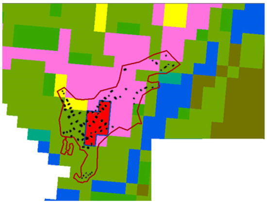 Figure 2. Distribution of buildings within the settlement of Pershlakhta superimposed on the used land-cover map (the red pixels show the built-up land-cover class, red line shows administrative boundary of the settlement, black rectangles show buildings).
- -
- An empirical constant Z that reflects precipitation and hydrogeological characteristics was estimated as 0.2 N according to [40], where N is the number of rains per year, i.e., the number of days with rainfall in periods with an average daily temperature above 0 °C [41].
The ES of prevention of soil erosion and soil flushing into water bodies was evaluated using the “Sediment Delivery Ratio” module. The calculation of potential soil erosion from bare soil USLEbare in the InVEST program is based on the universal soil loss equation (USLE):
where R is the rainfall erosivity factor, K is the soil erodibility factor, and LS is the terrain factor.
USLEbare = RKLS,
Actual soil erosion was calculated using Equation (7).
where C is the cover management factor, and P is the support practice factor for each land-cover type.
USLEactual(l(x)) = USLEbare C(l(x)) P(l(x)),
Prevented erosion was calculated as the difference between potential erosion and actual erosion.
The following parameters were used to calculate potential soil erosion:
- -
- Rainfall erosivity factor R was determined from 1 km resolution data of the Join Research Center of the European Soil Data Center (ESDAC) [42]. In the study area, this parameter varies from 280 to 335 MJ·mm/ha/hr.
- -
- The soil erodibility factor K was determined based on the soil types of the Harmonized World Soil Database HWSDB and the methodology of the Ontario Department of the ministry of Agriculture, Food, and Rural Affairs [43]. One of the most important properties determining soil erodibility is the content of clay, sand, silt, and coarse-grained particles. For soils in the study area, the K value varies from 0.005 to 0.05.
- -
- The terrain factor LS was calculated on the basis of a digital elevation model of the study area using the method of Desmet and Gowers [44] for a two-dimensional surface. It considers, in addition to the classical parameters of length L and steepness S of the slope, the exposure of the slope and the flow accumulation area at the inlet to the grid cell.
- -
- The cover management factor C was set as the average values for land-cover categories according to the materials [45,46]: 0.001 for swamps, 0.003 for forests, 0.31 for clearcuts (as for degraded land), and 0.27 for unvegetated anthropogenic areas. The coefficient for croplands and grasslands was calculated using the abovementioned methodology for the state of Ontario [43]. Two parameters were considered: crop type that is grass in the study area (coefficient is 0.02) and the absence of specialized processing equipment of tillage (coefficient is 0.25). Multiplying these two coefficients, the C factor for croplands and grasslands turned out to be extremely low (0.005), i.e., of the same order of magnitude, for swamps.
- -
- The support practice factor P is the coefficient of soil loss as a result of the presence of certain soil-protective structures (field-protective and snow-retaining forest belts, tree and shrub shafts, shrub thickets, and meadows in erosional landforms). It was set to 1.0, as no such structures are presented in the study area.
3. Results
3.1. General Results
The total values of the two considered Ess for the study area, maps of Ess (see Section 3.2 and Section 3.3) for different land-cover states (see Section 2), and estimates of the changes in regulated parameters due to land-cover changes were obtained (Table 1).

Table 1.
Total ES values and changes in regulated parameters.
3.2. Water Yield Regulation Due to Evapotranspiration
Our estimates show that the runoff from the study area varied from 159 mm/year in 2007 to 164 mm/year in 2021 (Table 1, Figure 3a), i.e., 26–27% of precipitation (605 mm/year). Vegetation reduced the runoff from the study area by 125 mm/year (Table 1, Figure 3b).
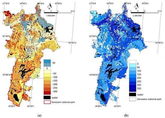
Figure 3.
ES of water yield regulation: (a) annual runoff in 2007 (mm/year); (b) runoff change due to evapotranspiration by vegetation (mm/year).
The largest runoff (250–333 mm/year) occurred from clearcuts older than 3 years, which were overgrown with grass (grassy clearcuts in Figure 4), fresh clearcuts, croplands, and built-up areas; forests were characterized by average values (173–211 mm/year), and there was almost not runoff from swamps (Figure 3a and Figure 4).
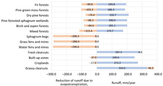
Figure 4.
Contribution of different land-cover types to the ES of water yield regulation: actual runoff (blue bars) and reduction in runoff due to evapotranspiration (orange bars).
Swamps reduced runoff the most (287–290 mm/year), as there was no runoff from them, and evapotranspiration was high (Figure 3b and Figure 4). Forests reduced runoff moderately (74–115 mm/year). Fir and mixed forests in the southern part of the territory, mainly within the boundaries of the national park, made the main contribution (100 mm/year). Deciduous and pine forests in the northern part of the territory reduced runoff to a lesser extent (Figure 3b). Croplands, fresh clearcuts, and built-up areas almost did not regulate the runoff. Grassy clearcuts even increased it a little (Figure 4). This can be explained by the fact that they were located mainly in the north of the study area (Figure 3b) in vast areas on podzolic soils with a large proportion of sand. The water-holding capacity of these soils was less than that in areas of fresh clearings and croplands located in other parts of the study area. In the north of the study area, there were areas of birch and aspen forests, which also slightly (by 5 mm/year) increased runoff (Figure 3b). These areas were located on illuvial–ferruginous podzols with a small root depth. If these forests are cut down, waterlogging can occur, and fens can form in their place.
Forest felling from 2007 to 2021 resulted in an increase in runoff by 6 mm/year, i.e., by 4% (Table 1). The runoff increased by 30–40 mm/year in fresh clearcuts, by 100–120 mm/year in grassy clearcuts older than 3 years, and by 150 mm/year in clearcuts in the southeastern part of the study area due to features of soil drainage there (Figure 5a). On old clearcuts, which by 2021 were overgrown with birch and aspen forests, the runoff, on the contrary, decreased by 110–130 mm/year.
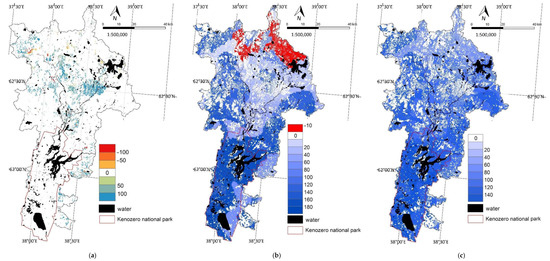
Figure 5.
Runoff changes due to forest felling: (a) changes in runoff between 2007 and 2021 (mm/year); (b) changes after hypothetical case of total forest felling, compared to 2021 (mm/year); (c) changes in runoff 3 years after total forest felling, compared to 2021 (mm/year).
To assess the full ES that forests provide, a hypothetical case of simultaneous total forest loss was tested. In this case, the runoff increased by 71 mm/year, i.e., by 43% (Table 1). It increased the most (by 160–180 mm/year) in the territory of the national park, where logging has not been carried out for several decades (Figure 5b). Increases in runoff were not so evident (by 60–100 mm/year) along the eastern border of the national park. These differences were determined by different types of soils and the conditions of their drainage. The runoff from swamps did not change in the InVEST model, although, in reality, the function of swamps should also change after such large-scale forest loss. In the north of the study area, in some areas currently occupied by birch and aspen forests, runoff decreased by 5–10 mm/year. As mentioned above, felling in these areas can lead to waterlogging. Three years later, when the clearcuts were overgrown with grass, runoff did not begin to return to the initial volume but increased by another 13 mm/year (Table 1). The maximum increase in runoff remained in the territory of the national park, although it was weaker than immediately after cutting (Figure 5c). In areas in the north of the study area, where the runoff decreased immediately after the total felling, after 3 years, it increased and became greater than before the felling.
3.3. Prevention of Soil Erosion and Soil Flushing into Water Bodies
The study area was characterized by a relatively low actual erosion (0.05–0.08 t/ha/year) (Table 1). The map of actual erosion in 2007 shows that, in areas of podzol soils, erosion did not exceed 0.02 t/ha/year (indicated in white in Figure 6a). The southern part of the study area (mostly within the territory of the national park) located on sod–podzolic soils was the most prone to erosion (average erosion = 0.1–0.2 t/ha/year, on the slopes = 0.5 t/ha/year). The heaviest erosion occurred in built-up areas (14 t/ha/year), as well as on croplands and fresh clearcuts (5–6 t/ha/year). Among forest areas, erosion was most noticeable in dry pine forests (1.1 t/ha/year). There was practically no erosion in swamps (Figure 7).
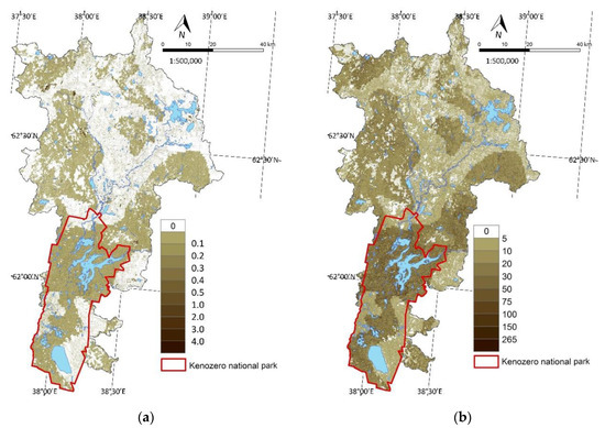
Figure 6.
ES of prevention of soil erosion and soil flushing into water bodies: (a) annual soil loss in 2007 (t/ha/year); (b) avoided erosion (t/ha/year).
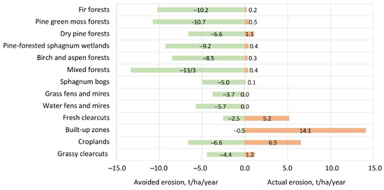
Figure 7.
Contribution of different land-cover types to the ES of prevention of soil erosion: actual (orange bars) and avoided erosion (green bars).
Vegetation prevented erosion of 9.56 t/ha/year (Table 1), i.e., 99% of potential erosion. The greatest contribution to this ES was made by forests (7–13 t/ha/year), especially mixed forests (Figure 7). Forests around Lake Kenozero protected 5 t/ha/year on relatively flat surfaces and up to 60–100 t/ha/year along steep slopes (Figure 6b). The relief was most pronounced around the lake, and potential erosion was the greatest here. Thus, the ES of preventing erosion was manifested to the maximum extent. Swamps and grassy areas prevented erosion twice as weakly as forests (4–7 t/ha/year) (Figure 7). Low values of prevented erosion (up to 5–10 t/ha/year) were also typical for the wide strip in the center of study area due to the high sand content (86%) in podzol soils there (Figure 6b).
Forest felling from 2007 to 2021 resulted in erosion increasing by 0.03 t/ha/year, i.e., 60% (Table 1). The maximum increase in erosion (up to 10–20 t/ha/year) occurred in fresh clearcuts in the western part of the study area, on soils with a high content of silt fractions (Figure 8a). In clearcuts on podzol soils, located in the southeastern part of the study area, erosion increased by no more than 1 t/ha/year. Erosion decreased in small areas of old clearings in the northwestern part of the territory, overgrown with forest during this time.
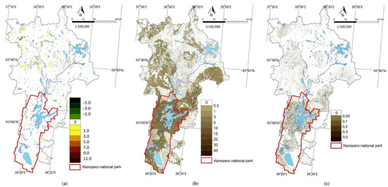
Figure 8.
Erosion changes due to forest felling: (a) changes in erosion between 2007 and 2021 (t/ha/year); (b) changes after hypothetical case of total forest felling, compared to 2021 (t/ha/year); (c) changes in erosion few years after total forest felling, compared to 2021 (t/ha/year).
In the hypothetical case of immediate total forest loss, erosion increased by 2.4 t/ha/year immediately after clearing (Table 1), i.e., more than 30-fold. The maximum increase occurred in the territory of Kenozero National Park (up to 12 t/ha/year on average) and on hilly areas (from 20 to 70 t/ha/year) (Figure 8b). Erosion significantly increased in areas with soddy–podzolic soils in the northern part of the study area (2–5 t/ha/year). On podzol soils, there were no significant increase in erosion (up to 0.5 t/ha/year). After 3 years, as clearcuts were overgrown with grass, the anti-erosion functions of vegetation were almost recovered, and erosion exceeded the initial value by only 0.01 t/ha/year (Table 1). However, an excess of erosion by 0.2–0.3 t/ha/year remained in the national park, as well as on the slopes around Lake Kenozero (up to 0.5 t/ha/year) (Figure 8c). In the northern part of the study area, in areas on soddy–podzolic soils with a heavy mechanical composition, the excess erosion was severalfold lower (from 0.01 to 0.10 t/ha/year).
4. Discussion
4.1. Compliance with Other Studies
Our estimates correspond to classic ideas about the increase in runoff and erosion due to forest loss [47]. For example, in central Sweden, with over 8 years of clearcutting, the average runoff increased by 85% and 110% (220 and 274 mm/year) in two basins that were cut down by 50% and 95% [48]. In European forests, on average, a 10% increase in forest area reduces runoff by 2–5% [49]. Studies using InVEST usually show a decrease in runoff (water yield) as a result of restoration of vegetation or an increase in runoff as a result of forest area reduction [6,12,13,14].
The average values of runoff (about 160 mm/year) and actual evapotranspiration (445 mm/year) obtained by us approximately correspond to other estimates of these indicators for the European boreal forests [50,51]. In the forests of Finland, which are similar in natural conditions to Kenozero forests, 20–70% of precipitation goes to runoff [49]. Our estimates show that about 27% of precipitation goes to runoff.
Our estimates of current erosion are consistent with Eurostat data, indicating that the average erosion in Finland for Corine land-cover classes of agricultural areas, forest, and semi-natural areas is 0.1 t/ha/year [52]. Apparently, in almost completely forested areas like the study area, erosion should be lower, which corresponds to our estimates of 0.05–0.08 t/ha/year.
4.2. Completeness of ES Assessment
We estimated only two components of water-regulating ESs: water yield regulation due to evapotranspiration and ensuring water quality due to preventing erosion. In our assessment, we did not assess several important water-regulating ES, which are directly affected by land use and forest management [3,5], as discussed below.
The first is the ES of separation of runoff into underground and surface components, groundwater recharge, and regulation of the water table. On average, in European regions with a forest area of 70–80% like in our study area, runoff is divided approximately in half between underground and surface components. This function is important not only within a watershed, but also beyond it. Local evapotranspiration can exceed by 20% or more the amount of precipitation if the vegetation uses groundwater coming from adjacent areas [53]. The function of groundwater recharge depends on a variety of geological, climatic, and soil factors; hence, the effects of afforestation or deforestation vary greatly from place to place [54]. In some water-scarce regions, reforestation can lead to undesirable lowering of the water table [3], and deforestation in regions with high water tables often leads to waterlogging [55]. Our estimates did not consider the division of runoff into underground and surface, although we found a tendency to waterlogging of certain areas where runoff decreased after deforestation.
The second is the ES of water retention by vegetation and soil, reduction in runoff peaks, water storage for the dry period, and prevention of floods. European boreal forests reduce runoff fluctuations by about 10% on average [49]. Swamps and swampy forests with the greatest water-retention capacity occupy a significant area in Kenozero catchment. Therefore, it can be expected that, in the study area, the function of stabilizing runoff can be expressed no worse than in average European forests.
The third is the ES of recycling and redistribution of atmospheric moisture and precipitation. The continental part of Eurasia is the most extensive zone, which, to the maximum extent, depends on this ES. From one-third to one-half of precipitation here is provided by vegetation evapotranspiration in windward territories [18]. About 80% of China’s water resources can be provided by moisture evaporating from the Eurasian continent [20]. Moreover, the active functioning of boreal forests in summer enhances moisture transport from oceans into continent [56]. Therefore, vegetation plays a key role in sustaining downwind precipitation, and significant land-use change could affect regional and continental precipitation [18]. The European part of Russia including the study area belongs to the regions with particularly high rates of vegetation-regulated moisture recycling.
4.3. Tradeoffs among ESs Related to Water Regulation
Different ESs can mutually reinforce each other (synergy) or be in conflict (tradeoff). ES synergies do not pose a major management problem, as actions to improve one ES simultaneously improve another. Tradeoffs, when the improvement of one ES worsens another, require a special analysis for adequate decision making.
Most often, trade offs are identified between ESs of different categories, primarily between provisioning and regulating ESs. The tradeoffs between agricultural food production (which is often also considered an ES) and most other ESs are evident, e.g., from results of the massive Grain for Green program in China [57,58]. The conflict between the goal of maximizing wood production and most of the forest’s regulating ESs is well known in forest management [5]. This tradeoff can manifest itself in negative relationships between the intensity of forest harvesting and regulating ES, and in the form of an oppositely directed dynamics of ES as forest exploitation intensifies [59]. Special technologies were developed in forest management for various goals, but the choice of their optimal combination remains an important problem [5]. A multifunctional forest management strategy can help solve it [60].
The ES of water yield behaves in the opposite way to other regulating ESs as it increases with deforestation. Therefore, the goal of increasing water yield is in synergy with ES of food production and in conflict with ES of soil and carbon conservation, as shown in studies using InVEST [12,13,14,61]. The need to optimize the conflict between water yield and other regulating ESs (soil erosion prevention and water quality assurance) is well known in forest management [5].
Within the group of water-regulating ES, the goals of ensuring the quantity and quality of water are in tradeoff. Our estimates for the Kenozero catchment confirmed that forest felling increases water yield and decreases water quality because of soil erosion.
Lastly, there is a tradeoff between different components of the same ES ensuring water amount (water availability). This is a conflict between forest functions of reducing river flow (i.e., water yield) and water redirection to other ecosystems and landscape compartments (groundwater, soil, and atmosphere). Some authors consider water yield in opposition to water conservation [61] with a reciprocal of water retention and water conservation capacity (e.g., [62,63]) or interpret runoff reduction due to forestation as an increase in moisture retention [49]. A key component of this conflict is the tradeoff between the ES of water yield and ES of precipitation recycling because of the fundamental negative relationship between NPP and water yield and positive relationship between NPP and evapotranspiration [57]. Thus, two aspects of the same ecosystem function of evapotranspiration are seen as two conflicting ESs. The question is whether we should consider the water yield or evapotranspiration.
Therefore, considering only the water yield ES can give to decision makers a fundamentally wrong idea of forest ESs. The general direction of forest functioning is not water yield reduction but an increase in total water reserves in different ecosystem compartments (soil and atmospheric moisture, groundwater).
4.4. Approaches to ES Management Having Their Incomplete Quantification
We quantified and mapped only two of the five water-regulating ESs discussed above. The following question arises: Can partial ES assessment be the basis for decision making in forest management?
Two estimated ESs are in a tradeoff because forest harvesting leads to a decrease in water quality and increase in water yield. This formally does not give arguments for choosing between conservation and harvesting strategies. Profit from timber can increase the likelihood of choosing the latter. However, comparing the strength of the impact of logging on these two ES argues for forest conservation. Our estimates show that logging has a stronger impact on water quality than on its quantity; forest felling from 2007 to 2021 led to an increase in water yield by 4% and an increase in erosion by 60%, while, in the hypothetical case of total deforestation, water yield increased immediately by 43%, while erosion increased 30-fold (Section 3.2 and Section 3.3).
Considering other ESs, even those not quantified for this area, increases the likelihood of choosing a forest conservation strategy. The ESs of water retention in soil and runoff stabilization appear to be the least important since the runoff variability coefficient in the study area is pretty low [51]. The ESs of groundwater recharge and water table maintenance are of medium importance since there are no problems with water supply in the study area, but waterlogging of clear cuts is undesirable.
The ESs of recycling and redistribution of atmospheric moisture and precipitation appear to be the most important for the region. As mentioned above, in the boreal forest zone, one-third to one-half of the precipitation can be the result of this ES [18]. In the context of climate change, it can be of key importance for ecosystem stability and climate regulation. For example, a realistic reforestation can increase summer precipitation by 7.6% ± 6.7% on average over Europe, potentially offsetting a substantial part of the projected precipitation decrease due to climate change [64]. The function of forests in enhancing the movement of moist air masses from the oceans into the continents [65,66] enhances forest importance for future climate regulation. Precipitation reduction is not predicted for our study area. In recent years, there has been a slight increase in precipitation in the European taiga zone (5% over 10 years). However, the simultaneous increase in temperature (0.6 °C over 10 years) makes the problem of maintaining the water balance of ecosystems very important. These trends are predicted to continue in the future [67,68], along with an increase in the risk of natural fires and an increase in the fire hazard period [69].
In the absence of quantitative ES estimates, the use of expert ES assessment is quite reasonable, since the impact of non-quantified ES on quantified ones can be significant. For example, the ES of dividing runoff into surface and groundwater components and the ES of precipitation recycling can change runoff and precipitation by 20% to 50% (Section 4.2). Thus, taking into account even an approximate qualitative expert assessment of ES seems to be more appropriate than completely ignoring ES, which cannot currently be quantified.
When choosing the optimal forest management strategy, it is also necessary to consider ES dynamics and spatial scale, as well as the impact of forest diversity on ES.
Clear-cutting leads to an immediate decrease in evapotranspiration and an increase in runoff. Then, rapid reforestation can, conversely, significantly reduce runoff [3,5]. However, our estimates showed that, 3 years after the total deforestation, the runoff continued to grow, albeit at a slower rate (Section 3.2). It takes decades to restore ESs such as runoff stabilization and groundwater recharge [3,5]. As for erosion, our estimates show that, after total deforestation, it can decrease quite quickly as the clearings become overgrown with grass, but the damage from multiple increases in erosion immediately after forest felling can be great (Section 3.3).
In local catchments, the river flow increases after deforestation; however, in larger basins, forest disturbance interacts with the climate, and this leads to more complex and diverse hydrological effects [70]. Accounting for the ES of redistribution and recycling of precipitation requires a transition from the scale of local watersheds of hundreds of square kilometers to precipitation sheds, which can be many thousand square kilometers and have a continental scale [71]. That is, the water-regulating ESs of the Kenozero forests can extend much further than the catchments of Lakes Kenozero and Lache and even the Onega River, which flows into the White Sea. The prevailing movement of air masses from the west distributes precipitation from Kenozero forests throughout the entire European part of Russia. Of course, forests of other regions also contribute to this precipitation shed. Some estimates show that Kenozero forests are a part of precipitation sheds that provide precipitation for most of Eurasia, including the water-deficient regions of China and southwestern Asia (Figure 9) [71].
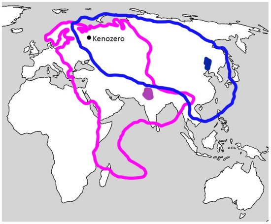
Figure 9.
An example of two precipitation sheds which the Kenozero watershed belongs: light and dark purple colors show the boundary of the precipitation shed and the sink region in Pakistan and light and dark blue colors show the boundary of the precipitation shed and the sink region in China (after [71] with simplification).
Forest biodiversity (species diversity, age of trees and forest stands, and diversity of forest structure and forest types) is a key factor of ecosystem functions and ESs [72,73,74,75]. Natural multi-species forests use water more efficiently than plantations, especially monocultures [3,5]. Inclusion of native species and natural processes in forest restoration can increase some hydrological benefits relative to other forest restoration approaches [76]. Boreal European coniferous forests retain about 40% of precipitation, while deciduous forests retain less than 10% [49]. Mature and old-growth forests have high evapotranspiration and consistent water yield, provide moderated peak discharges, and sustain low flows, while managed forest plantations provide low water yield, especially during dry periods [76].
Thus, our results and discussions highlighted the following issues in the use of assessments of water management services in forest management:
- -
- Evaluation of only one selected water-regulating ES, such as regulation of water yield due to evapotranspiration, can lead to incorrect management conclusions about the optimal intensity of forest exploitation.
- -
- Considering a broader range of ES strengthens argues for a forest conservation strategy instead of a forest exploitation.
- -
- The inclusion of the ES of precipitation recycling in decision making is necessary in the context of climate change. The development of interregional and international markets of water-regulating ESs of forests requires a transition from the scale of a local catchments to a regional or even continental scale.
- -
- Local assessments and mapping of individual ESs are useful for territorial planning of forest protection and use within certain areas, as they allow identifying the importance of different types of vegetation, features of soils, and topography in maintaining ES (Section 3.2 and Section 3.3).
5. Conclusions
Our estimation of two water-regulating ESs (water yield regulation due to evapotranspiration and water quality assurance due to prevention of soil erosion) revealed the tradeoff between them. Forest harvesting leads to a water yield increase due to evapotranspiration weakening and water quality decrease due to soil erosion. Formally, this tradeoff makes it difficult to choose between harvesting and conservation forest management strategies, while the profit from timber increases the likelihood of choosing the harvesting strategy.
However, the use of a more complete set of ESs (including regulation of water table and precipitation recycling), even at the level of approximate expert estimates, increases the likelihood of choosing a conservation strategy instead of a harvesting one in forest management. Given the projected future climate change, the most important forest ES, which should be included in the decision-making process, is recycling and redistribution of air moisture and precipitation. Incorporating this ES into decision making requires extending the spatial scale from local watersheds to precipitation sheds of subcontinental and even continental scale.
Author Contributions
Conceptualization, E.B.; methodology, L.P., E.B. and A.A.; formal analysis, L.P.; investigation, L.P., E.B. and A.A.; writing, L.P., E.B. and A.A.; visualization, L.P. and E.B. All authors read and agreed to the published version of the manuscript.
Funding
This research was funded by Kenozero National Park.
Data Availability Statement
Not applicable.
Conflicts of Interest
The authors declare no conflict of interest.
References
- IPBES. Global Assessment Report on Biodiversity and Ecosystem Services of the Intergovernmental Science-Policy Platform on Biodiversity and Ecosystem Services; Brondizio, E.S., Settele, J., Díaz, S., Ngo, H.T., Eds.; IPBES Secretariat: Bonn, Germany, 2019; 1148p. [Google Scholar] [CrossRef]
- WWAP (United Nations World Water Assessment Programme)/UN-Water. The United Nations World Water Development Report 2018: Nature-Based Solutions for Water. UNESCO, 2018. 2018. Available online: https://unesdoc.unesco.org/ark:/48223/pf0000261424 (accessed on 19 October 2022).
- Creed, I.; van Noordwijk, M. Forest and Water on a Changing Planet: Vulnerability, Adaptation and Governance Opportunities. A Global Assessment Report; International Union of Forest Research Organizations (IUFRO): Vienna, Austria, 2018; Volume 38, Available online: https://www.iufro.org/publications/series/world-series/article/2018/07/10/world-series-vol-38-forest-and-water-on-a-changing-planet-vulnerability-adaptation-and-governan/ (accessed on 19 October 2022).
- Ellison, D.; Morris, C.E.; Locatelli, B.; Sheil, D.; Cohen, J.; Murdiyarso, D.; Gutierrez, V.; Noordwijk, M.; van Creed, I.F.; Pokorny, J.; et al. Trees, forests and water: Cool insights for a hot world. Glob. Environ. Chang. 2017, 43, 51–61. [Google Scholar] [CrossRef]
- FAO; IUFRO; USDA. A Guide to Forest—Water Management; FAO, IUFRO and USDA: Rome, Italy, 2021. [Google Scholar] [CrossRef]
- Gaglio, M.; Aschonitis, V.; Pieretti, L.; Santos, L.; Gissi, E.; Castaldelli, G.; Fano, E.A. Modelling past, present and future Ecosystem Services supply in a protected floodplain under land use and climate changes. Ecol. Model. 2019, 403, 23–34. [Google Scholar] [CrossRef]
- Jia, G.; Hu, W.; Zhang, B.; Li, G.; Shen, S.; Gao, Z.; Li, Y. Assessing impacts of the Ecological Retreat project on water conservation in the Yellow River Basin. Sci. Total Environ. 2022, 828, 154483. [Google Scholar] [CrossRef] [PubMed]
- Karp, D.S.; Tallis, H.; Sachse, R.; Halpern, B.; Thonicke, K.; Cramer, W.; Mooney, H.; Polasky, S.; Tietjen, B.; Waha, K.; et al. National indicators for observing ecosystem service change. Glob. Environ. Chang. 2015, 35, 12–21. [Google Scholar] [CrossRef]
- Li, D.; Wu, S.; Liu, L.; Liang, Z.; Li, S. Evaluating regional water security through a freshwater ecosystem service flow model: A case study in Beijing-Tianjian-Hebei region, China. Ecol. Indic. 2017, 81, 159–170. [Google Scholar] [CrossRef]
- Lüke, A.; Hack, J. Comparing the Applicability of Commonly Used Hydrological Ecosystem Services Models for Integrated Decision-Support. Sustainability 2018, 10, 346. [Google Scholar] [CrossRef]
- Pandeya, B.; Buytaert, W.; Zulkafli, Z.; Karpouzoglou, T.; Mao, F.; Hannah, D.M. A comparative analysis of ecosystem services valuation approaches for application at the local scale and in data scarce regions. Ecosyst. Serv. 2016, 22, 250–259. [Google Scholar] [CrossRef]
- Peng, J.; Hu, X.; Wang, X.; Meersmans, J.; Liu, Y.; Qiu, S. Simulating the impact of Grain-for-Green Programme on ecosystem services trade-offs in Northwestern Yunnan, China. Ecosyst. Serv. 2019, 39, 100998. [Google Scholar] [CrossRef]
- Wang, J.; Peng, J.; Zhao, M.; Liu, Y.; Chen, Y. Significant trade-off for the impact of Grain-for-Green Programme on ecosystem services in North-western Yunnan, China. Sci. Total Environ. 2017, 574, 57–64. [Google Scholar] [CrossRef]
- Zhao, J.; Li, C. Investigating spatiotemporal dynamics and trade-off/synergy of multiple ecosystem services in response to land cover change: A case study of Nanjing city, China. Environ. Monit. Assess. 2020, 192, 701. [Google Scholar] [CrossRef]
- Bennett, B.M.; Barton, G.A. The enduring link between forest cover and rainfall: A historical perspective on science and policy discussions. For. Ecosyst. 2018, 5, 5. [Google Scholar] [CrossRef]
- Ellison, D. Forests and Water. Background Analytical Study 2. United Nations, 2018. Available online: https://www.un.org/esa/forests/wp-content/uploads/2018/04/UNFF13_BkgdStudy_ForestsWater.pdf (accessed on 19 October 2022).
- Filoso, S.; Bezerra, M.O.; Weiss KC, B.; Palmer, M.A. Impacts of forest restoration on water yield: A systematic review. PLoS ONE 2017, 12, e0183210. [Google Scholar] [CrossRef] [PubMed]
- Keys, P.W.; Wang-Erlandsson, L.; Gordon, L.J. Revealing invisible Water: Moisture recycling as an ecosystem service. PLoS ONE 2016, 11, e0151993. [Google Scholar] [CrossRef] [PubMed]
- Tuinenburg, O.A.; Theeuwen JJ, E.; Staal, A. High-resolution global atmospheric moisture connections from evaporation to precipitation. Earth Syst. Sci. Data 2020, 12, 3177–3188. [Google Scholar] [CrossRef]
- van der Ent, R.J.; Savenije HH, G.; Schaefli, B.; Steele-Dunne, S.C. Origin and fate of atmospheric moisture over continents. Water Resour. Res. 2010, 46, W09525. [Google Scholar] [CrossRef]
- Spracklen, D.V.; Arnold, S.R.; Taylor, C.M. Observations of increased tropical rainfall preceded by air passage over forests. Nature 2012, 489, 282–285. [Google Scholar] [CrossRef]
- Swann, A.L.S.; Laguë, M.M.; Garcia, E.S.; Field, J.P.; Breshears, D.D.; Moore DJ, P.; Saleska, S.R.; Stark, S.C.; Villegas, J.C.; Law, D.J.; et al. Continental-scale consequences of tree die-offs in North America: Identifying where forest loss matters most. Environ. Res. Lett. 2018, 13, 055014. [Google Scholar] [CrossRef]
- Lawrence, D.; Vandecar, K. Effects of tropical deforestation on climate and agriculture. Nat. Clim. Chang. 2015, 5, 27–36. [Google Scholar] [CrossRef]
- Hoek van Dijke, A.J.; Herold, M.; Mallick, K.; Benedict, I.; Machwitz, M.; Schlerf, M.; Pranindita, A.; Theeuwen JJ, E.; Bastin, J.-F.; Teuling, A.J. Shifts in regional water availability due to global tree restoration. Nat. Geosci. 2022, 15, 363–368. [Google Scholar] [CrossRef]
- te Wierik, S.A.; Cammeraat EL, H.; Gupta, J.; Artzy-Randrup, Y.A. Reviewing the Impact of Land Use and Land-Use Change on Moisture Recycling and Precipitation Patterns. Water Resour. Res. 2021, 57, e2020WR029234. [Google Scholar] [CrossRef]
- Bukvareva, E.N.; Kozykin, A.V. The first stage of ecosystem accounting in the Kenozersky National Park as a pilot project for the system of protected areas in Russia. In Kenozero Readings 2021. Protected Areas of the Russian North in the Context of Social, Humanitarian and Natural Science Research; Shatkovskaya, E.F., Ed.; Kenozersky National Park: Arkhangelsk, Russia, 2022; pp. 434–443. (In Russian) [Google Scholar]
- Kobyakov, K.N. (Ed.) Mapping of High Conservation Value Areas in Northwestern Russia: Gap-Analysis of the Protected Areas Network in the Murmansk, Leningrad, Arkhangelsk, Vologda, and Karelia regions, and the city of Saint-Petersburg; Kola Wildlife Conservation Center: St. Petersburg, Russia, 2011. (In Russian) [Google Scholar]
- High Conservation Value Forests. Available online: https://hcvf.ru/ru/maps (accessed on 19 October 2022).
- Hansen, M.C.; Potapov, P.V.; Moore, R.; Hancher, M.; Turubanova, S.A.; Tyukavina, A.; Thau, D.; Stehman, S.V.; Goetz, S.J.; Loveland, T.R.; et al. High-Resolution Global Maps of 21st-Century Forest Cover Change. Science 2013, 342, 850–853. [Google Scholar] [CrossRef] [PubMed]
- Global Forest Watch (GFW). Available online: https://data.globalforestwatch.org/documents/tree-cover-loss/explore (accessed on 19 October 2022).
- River Basins of European Russia. Available online: http://mapadmin.bassepr.kpfu.ru/content/services/18 (accessed on 19 October 2022).
- NextGIS. Available online: https://data.nextgis.com/ru/region/RU-ARK/base/ (accessed on 19 October 2022).
- WorldClim. Available online: https://www.worldclim.org/data/worldclim21.html (accessed on 19 October 2022).
- CGIAR Consortium for Spatial Information (CGIAR-CSI). Available online: https://cgiarcsi.community/data/global-aridity-and-pet-database/ (accessed on 19 October 2022).
- Harmonized World Soil Database (HWSD). Available online: https://iiasa.ac.at/models-and-data/harmonized-world-soil-database (accessed on 19 October 2022).
- Schenk, H.J.; Jackson, R.B. Rooting depths, lateral root spreads and below-ground/above-ground allometries of plants in water-limited ecosystems. J. Ecol. 2002, 90, 480–494. [Google Scholar] [CrossRef]
- Copernicus Global Land Service. Available online: https://land.copernicus.eu/global/products/lai (accessed on 19 October 2022).
- Allen, R.G.; Pereira, L.S.; Raes, D.; Smith, M. Crop Evapotranspiration-Guidelines for Computing Crop Water Requirements-FAO Irrigation and Drainage Paper 56; FAO: Rome, Italy, 1998; Volume 300, p. D0 5109.
- Atlas of the Arkhangelsk Region; Main Directorate of Geodesy and Cartography under the Council of Ministers of the USSR: Moscow, Russia, 1976; 38p. (In Russian)
- Donohue, R.J.; Roderick, M.L.; McVicar, T.R. Roots, storms and soil pores: Incorporating key ecohydrological processes into Budyko’s hydrological model. J. Hydrol. 2012, 436–437, 35–50. [Google Scholar] [CrossRef]
- Weather in Russia. Available online: http://russia.pogoda360.ru/ (accessed on 19 October 2022).
- Join Research Center of the European Soil Data Center (ESDAC). Available online: https://esdac.jrc.ec.europa.eu/content/global-rainfall-erosivity#tabs-0-description=0 (accessed on 19 October 2022).
- Ontario Department of the Ministry of Agriculture, Food and Rural Affairs. Available online: http://www.omafra.gov.on.ca/english/engineer/facts/12-051.htm (accessed on 19 October 2022).
- Desmet, P.J.J.; Govers, G. A GIS procedure for automatically calculating the USLE LS factor on topographically complex landscape units. J. Soil Water Conserv. 1996, 51, 427–433. [Google Scholar]
- Ebabu, K.; Tsunekawa, A.; Haregeweyn, N.; Tsubo, M.; Adgo, E.; Fenta, A.; Meshesha, D.; Berihun, M.; Sultan, D.; Vanmaercke, M.; et al. Global analysis of cover management and support practice factors that control soil erosion and conservation. Int. Soil Water Conserv. Res. 2022, 10, 161–176. [Google Scholar] [CrossRef]
- Panagos, P.; Borrelli, P.; Meusburger, K.; Alewell, C.; Lugato, E.; Montanarella, L. Estimating the soil erosion cover-management factor at the European scale. Land Use Policy 2015, 48, 38–50. [Google Scholar] [CrossRef]
- Bosch, J.M.; Hewlett, J.D. A review of catchment experiments to determine the effect of vegetation changes on water yield and evapotranspiration. J. Hydrol. 1982, 55, 3–23. [Google Scholar] [CrossRef]
- Rosén, K.; Aronson, J.-A.; Eriksson, H.M. Effects of clear-cutting on streamwater quality in forest catchments in central Sweden. For. Ecol. Manag. 1996, 83, 237–244. [Google Scholar] [CrossRef]
- European Environment Agency. Water retention potentials of Europe’s forests. In A European Overview Support to Natural Water Retention Measures; EEA Technical Report No 13/2015; European Environment Agency: Copenhagen, Denmark, 2015; 41p, ISBN 978-92-9213-694-9. [Google Scholar] [CrossRef]
- Liu, Y.; Jiang, Q.; Wang, Q.; Jin, Y.; Yue, Q.; Yu, J.; Zheng, Y.; Jiang, W.; Yao, X. The divergence between potential and actual evapotranspiration: An insight from climate, water, and vegetation change. Sci. Total Environ. 2022, 807, 150648. [Google Scholar] [CrossRef]
- Stolbovoi, V.; McCallum, I. Land Resources of Russia (CD-ROM). International Institute for Applied Systems Analysis and the Russian Academy of Science, Laxenburg, Austria, 2002. Available online: http://webarchive.iiasa.ac.at/Research/FOR/russia_cd/guide.htm (accessed on 19 October 2022).
- Eurostat. Available online: https://ec.europa.eu/eurostat/statistics-explained/index.php?title=Agri-environmental_indicator_-_soil_erosion (accessed on 19 October 2022).
- Brooks, P.D.; Chorover, J.; Fan, Y.; Godsey, S.E.; Maxwell, R.M.; McNamara, J.P.; Tague, C. Hydrological partitioning in the critical zone: Recent advances and opportunities for developing transferable understanding of water cycle dynamics: Critical zone hydrology. Water Resour. Res. 2015, 51, 6973–6987. [Google Scholar] [CrossRef]
- Acharya, B.; Kharel, G.; Zou, C.; Wilcox, B.; Halihan, T. Woody Plant Encroachment Impacts on Groundwater Recharge: A Review. Water 2018, 10, 1466. [Google Scholar] [CrossRef]
- Runyan, C.W.; D’Odorico, P.; Lawrence, D. Physical and biological feedbacks of deforestation. Rev. Geophys. 2012, 50, RG4006. [Google Scholar] [CrossRef]
- Makarieva, A.M.; Gorshkov, V.G.; Li, B.-L. Revisiting forest impact on atmospheric water vapor transport and precipitation. Theor. Appl. Climatol. 2013, 111, 79–96. [Google Scholar] [CrossRef]
- Jia, X.; Fu, B.; Feng, X.; Hou, G.; Liu, Y.; Wang, X. The tradeoff and synergy between ecosystem services in the Grain-for-Green areas in Northern Shaanxi, China. Ecol. Indic. 2014, 43, 103–113. [Google Scholar] [CrossRef]
- Liu, D.; Chen, Y.; Cai, W.; Dong, W.; Xiao, J.; Chen, J.; Zhang, H.; Xia, J.; Yuan, W. The contribution of China’s Grain to Green Program to carbon sequestration. Landsc. Ecol. 2014, 29, 1675–1688. [Google Scholar] [CrossRef]
- Sing, L.; Metzger, M.J.; Paterson, J.S.; Ray, D. A review of the effects of forest management intensity on ecosystem services for northern European temperate forests with a focus on the UK. For. Int. J. For. Res. 2018, 91, 151–164. [Google Scholar] [CrossRef]
- Schwaiger, F.; Poschenrieder, W.; Biber, P.; Pretzsch, H. Ecosystem service trade-offs for adaptive forest management. Ecosyst. Serv. 2019, 39, 100993. [Google Scholar] [CrossRef]
- Pan, T.; Zuo, L.; Zhang, Z.; Zhao, X.; Sun, F.; Zhu, Z.; Liu, Y. Effects of Afforestation Projects on Tradeoffs between Ecosystem Services: A Case Study of the Guanting Reservoir Basin, China. Forests 2022, 13, 232. [Google Scholar] [CrossRef]
- Xie, W.; Huang, Q.; He, C.; Zhao, X. Projecting the impacts of urban expansion on simultaneous losses of ecosystem services: A case study in Beijing, China. Ecol. Indic. 2018, 84, 183–193. [Google Scholar] [CrossRef]
- Zhang, B.; Xie, G.; Zhang, C.; Zhang, J. The economic benefits of rainwater-runoff reduction by urban green spaces: A case study in Beijing, China. J. Environ. Manag. 2012, 100, 65–71. [Google Scholar] [CrossRef] [PubMed]
- Meier, R.; Schwaab, J.; Seneviratne, S.I.; Sprenger, M.; Lewis, E.; Davin, E.L. Empirical estimate of forestation-induced precipitation changes in Europe. Nat. Geosci. 2021, 14, 473–478. [Google Scholar] [CrossRef]
- Makarieva, A.M.; Gorshkov, V.G. The Biotic Pump: Condensation, atmospheric dynamics and climate. Int. J. Water 2010, 5, 365. [Google Scholar] [CrossRef]
- Makarieva, A.M.; Gorshkov, V.G.; Sheil, D.; Nobre, A.D.; Li, B.-L. Where do winds come from? A new theory on how water vapor condensation influences atmospheric pressure and dynamics. Atmos. Chem. Phys. 2013, 13, 1039–1056. [Google Scholar] [CrossRef]
- Report on Climate Risks in the Russian Federation. St. Petersburg. 2017. Available online: http://cc.voeikovmgo.ru/images/dokumenty/2017/riski.pdf (accessed on 19 October 2022).
- Report on Climate Features on the Territory of the Russian Federation in 2021. Moscow, 2022. Available online: https://www.meteorf.gov.ru/images/news/20220324/4/Doklad.pdf (accessed on 19 October 2022).
- Second Roshydromet Assessment Report on Climate Change and Its Consequences in Russian Federation. General Summary. Federal Service for Hydrometeorology and Environmental Monitoring (Roshydromet): Moscow, Russia, 2014. Available online: http://downloads.igce.ru/publications/OD_2_2014/v2014/htm/ (accessed on 19 October 2022).
- Wei, X.; Giles-Hansen, K.; Spencer, S.A.; Ge, X.; Onuchin, A.; Li, Q.; Burenina, T.; Ilintsev, A.; Hou, Y. Forest harvesting and hydrology in boreal Forests: Under an increased and cumulative disturbance context. For. Ecol. Manag. 2022, 522, 120468. [Google Scholar] [CrossRef]
- Keys, P.W.; van der Ent, R.J.; Gordon, L.J.; Hoff, H.; Nikoli, R.; Savenije, H.H.G. Analyzing precipitationsheds to understand the vulnerability of rainfall dependent regions. Biogeosciences 2012, 9, 733–746. [Google Scholar] [CrossRef]
- Liang, J.; Crowther, T.W.; Picard, N.; Wiser, S.; Zhou, M.; Alberti, G.; Schulze, E.-D.; McGuire, A.D.; Bozzato, F.; Pretzsch, H.; et al. Positive biodiversity-productivity relationship predominant in global forests. Science 2016, 354, aaf8957. [Google Scholar] [CrossRef]
- van der Plas, F. Biodiversity and ecosystem functioning in naturally assembled communities. Biol. Rev. 2019, 94, 1220–1245. [Google Scholar] [CrossRef]
- Shin, Y.J.; Arneth, A.; Roy Chowdhury, R.; Midgley, G.F.; Leadley, P.; Agyeman Boafo, Y.; Basher, Z.; Bukvareva, E.; Heinimann, A.; Horcea-Milcu, A.I.; et al. Chapter 4: Plausible futures of nature, its contributions to people and their good quality of life. In Global Assessment Report of the IPBES; Brondizio, E.S., Settele, J., Diaz, S., Ngo, H.T., Eds.; IPBES Secretariat: Bonn, Germany, 2019. [Google Scholar]
- Visconti, P.; Elias, V.; Sousa Pinto, I.; Fischer, M.; Ali-Zade, V.; Bбldi, A.; Brucet, S.; Bukvareva, E.; Byrne, K.; Caplat, P.; et al. Chapter 3: Status, trends and future dynamics of biodiversity and ecosystems underpinning nature’s contributions to people. In IPBES: The IPBES Regional Assessment Report on Biodiversity and Ecosystem Services for Europe and Central Asia; Rounsevell, M., Fischer, M., Torre-Marin Rando, A., Mader, A., Eds.; Secretariat of the IPBES: Bonn, Germany, 2018; pp. 187–382. [Google Scholar] [CrossRef]
- Jones, J.; Ellison, D.; Ferraz, S.; Lara, A.; Wei, X.; Zhang, Z. Forest restoration and hydrology. For. Ecol. Manag. 2022, 520, 120342. [Google Scholar] [CrossRef]


Publisher’s Note: MDPI stays neutral with regard to jurisdictional claims in published maps and institutional affiliations. |
© 2022 by the authors. Licensee MDPI, Basel, Switzerland. This article is an open access article distributed under the terms and conditions of the Creative Commons Attribution (CC BY) license (https://creativecommons.org/licenses/by/4.0/).