Article

Identifying Meteorologic and Oceanic Conditions Contributing to a Unique Phytoplankton Bloom Occurrence in Micronesia during October 2013

1
Goddard Earth Sciences Data and Information Services Center/Adnet Systems Inc., Code 610.2, NASA Goddard Space Flight Center, Greenbelt, MD 20771, USA
2
NASA Goddard Space Flight Center, Greenbelt, MD 20771, USA
*
Author to whom correspondence should be addressed.
Retired.
Earth 2022, 3(3), 951-974; https://doi.org/10.3390/earth3030056
Submission received: 12 July 2022 / Revised: 31 August 2022 / Accepted: 5 September 2022 / Published: 10 September 2022

Abstract

:
On the first several days of October 2013, daily chlorophyll a (chl a) data acquired by the Moderate Resolution Imaging Spectroradiometer (MODIS) onboard the National Aeronautics and Space Administration (NASA) Aqua satellite detected a marked increase in chlorophyll a concentrations (chl a) in the vicinity of Chuuk Lagoon and the Federated States of Micronesia. Such an increase, likely indicative of a phytoplankton bloom, has not been observed in this location at any other time during the MODIS-Aqua mission, which commenced in 2002 and continues to present. Examination of sea surface wind data from the Modern Era Retrospective analysis for Research and Applications Version 2 (MERRA-2) reanalysis dataset indicated that the region experienced a sequence of alternating elevated and very low wind speed events prior to the observation of the bloom. The influence of the winds can be seen in MERRA-2 sea surface skin temperature data. Elevated windspeeds for several days likely induced a mixing of deeper waters with higher nutrient levels to the surface, which was followed by stratification and phytoplankton growth during low wind intervals and finally transport induced by a brief high windspeed event. Analysis of hourly MERRA-2 maximum windspeed data over a 40-year period indicated that this sequence was climatologically rare.

1. Introduction

The basic factors which foster a phytoplankton bloom in marine and lacustrine waters are well known. What is required is a standing stock of phytoplankton, sufficient nutrient concentrations, a stratified water column, and sunlight for photosynthesis. Alhough these factors are well-known, there are numerous different mechanisms that provide these factors [1]. Nutrients can be provided in several ways: from terrestrial sources delivered to bodies of water by rivers and streams; via upwelling or wind-mixing from deeper waters; or from airborne pathways both natural and anthropogenic. Seasonal “spring” blooms occur as surface water temperatures increase and sunlight hours also increase, and the growing phytoplankton population utilizes replenished nutrient concentrations in surface waters as water column stratification is established. These factors contribute to the development of a bloom, which is generally defined as a period of increased or accelerated phytoplankton growth resulting in a relatively rapid increase in water column phytoplankton population. The phytoplankton population in a bloom will considerably exceed the normal background population.
One of the main common factors for both sustained phytoplankton growth in productive regions and for episodic phytoplankton blooms is ocean surface winds. Upwelling zones, such as the Peru and Benguela upwelling zones, are caused by sustained winds in a single alongshore direction that induce Ekman circulation in the water column, which induces an upwelling of deep waters with elevated nutrient concentrations adjacent to the coast. Episodic wind-mixing events, such as those which occur on the Pacific Ocean side of the Central American cordillera in the boreal winter, [2] cause brief (multi-day) phytoplankton blooms as elevated linear winds mix deeper waters with elevated nutrient concentrations to the surface. These events also have a recognizable signature, as elevated wind speeds are followed by decreased SST, which is followed by increased chlorophyll a concentrations (chl a).
Anomalous wind-associated phytoplankton blooms: While recurring episodic wind-mixed or upwelling-induced phytoplankton blooms have been frequently described and are well studied in the oceanographic literature, the occurrence of anomalous blooms caused by wind events is not as commonly described. By their very nature as anomalous (meaning that they occur in locations or at times that blooms are not commonly observed), such events are relatively unpredictable, and they can be short-lived and ephemeral, thus making their study more difficult. Despite this relative rarity, some events of this type have been described. Kubryakov, Zatsepin, and Stanichny (2019) [3] observed anomalous phytoplankton blooms in the Black Sea persisting for a period of about three months, which were caused by four consecutive strong wind events. Another event in the Black Sea which caused an anomalous autumn bloom was a quasi-tropical cyclone occurring 25–29 September 2005. This event is described in Stanichny, Kubryakova, and Kubryakov (2021) [4]. Chow et al. (2019) [5] describes a very large phytoplankton bloom occurring in 2010, which was fostered by anomalous anticyclonic winds in the oligotrophic waters of the North Pacific Subtropical Gyre. In the Bay of Bengal and Arabian Sea ocean regions, Chen et al. (2013) [6] observed anomalous winds in January 1998 and December 2005 which caused phytoplankton blooms detected in Sea-viewing Wide Field-of-view Sensor (SeaWiFS) chl a data. The latter event described in this paper may have been enhanced and sustained by the passage of three tropical cyclones. An absence of wind can also be an important factor, particularly in shallow tropical reef environments; Furnas et al. (1990) [7] importantly note that phytoplankton blooms developed in lagoons of the Great Barrier Reef during intermittent calm periods when water residence times exceed phytoplankton generation times.
With the exception of Furnas et al. (1990), the mechanism of the generation of an anomalous phytoplankton bloom by anomalous winds is essentially the same. The essential step occurs when nutrients from subsurface waters are brought to the surface by the wind event or events, providing the stimulus for rapid phytoplankton growth. These events create wind-driven currents at the surface, and they can be augmented by interactions with the local oceanic current environment. Their duration is determined both by the length of the wind event causing the bloom and the oceanic conditions set up by the winds, which ultimately determine the amount of nutrients which will nourish the elevated concentrations of actively growing phytoplankton. In order for the bloom to occur, sufficient light must be available for photosynthesis. The development of stratification due to higher sea surface temperature, concentrating nutrients in a shallow layer, is also an important factor.
The October 2013 anomalous phytoplankton bloom: During October 2013, during the routine examination of daily ocean color images acquired by NASA’s Moderate Resolution Imaging Spectroradiometer (MODIS) on the Aqua satellite, Norman Kuring of the NASA Ocean Biology Distributed Active Archive Center (OBDAAC) observed a sinuous feature of elevated chl a emanating from Chuuk Lagoon in the western tropical Pacific Ocean and extending east. Maximum concentrations of approximately 0.4–0.5 mg/m3 were located south and east of Chuuk Lagoon, and lower concentrations extended toward Pohnpei. Elevated chl a was also observed east of Pohnpei. No other feature of comparable magnitude and extent has been observed here before or after the October 2013 event. In this paper, factors which could have caused this very unusual event are described and evaluated to determine the likeliest cause.

2. Materials and Methods

In order to investigate the wind regime occurring in this region and the time period of the event, a dataset with high temporal resolution and full coverage of the region would be useful. The Modern-Era Retrospective analysis for Research and Applications (MERRA-2) dataset [8] is archived and distributed by the NASA Goddard Earth Sciences Data and Information Services Center (GES DISC), and provides several wind data products at hourly temporal resolution. The MERRA-2 wind data are available for analysis and visualization in the Geospatial Interactive Online Visualization and Analysis Infrastructure (Giovanni), which is a Web data service provided by the GES DISC [9].
McCarty et al. (2016) [10] describes the input observations for the MERRA-2 data assimilation process. For winds that occurred during October 2013, the following surface wind data were included in the reanalysis:
  • Japanese Meteorological Agency (JMA) Atmospheric Motion Vectors;
  • European Organisation for the Exploitation of Meteorological Satellites (EUMETSAT) Atmospheric Motion Vectors;
  • National Oceanic and Atmospheric Administration (NOAA) Geostationary Operational Environmental Satellite (GOES) Atmospheric Motion Vectors;
  • NOAA/EUMETSAT Advanced Very High-Resolution Radiometer (AVHRR) Atmospheric Motion Vectors;
  • MODIS winds;
  • Special Sensor Microwave Imager (SSM/I) and Special Sensor Microwave Imager/Sounder (SSMIS) Wind Speed—the use of these data ended on 29 October 2013;
  • Advanced Scatterometer (ASCAT) surface winds.
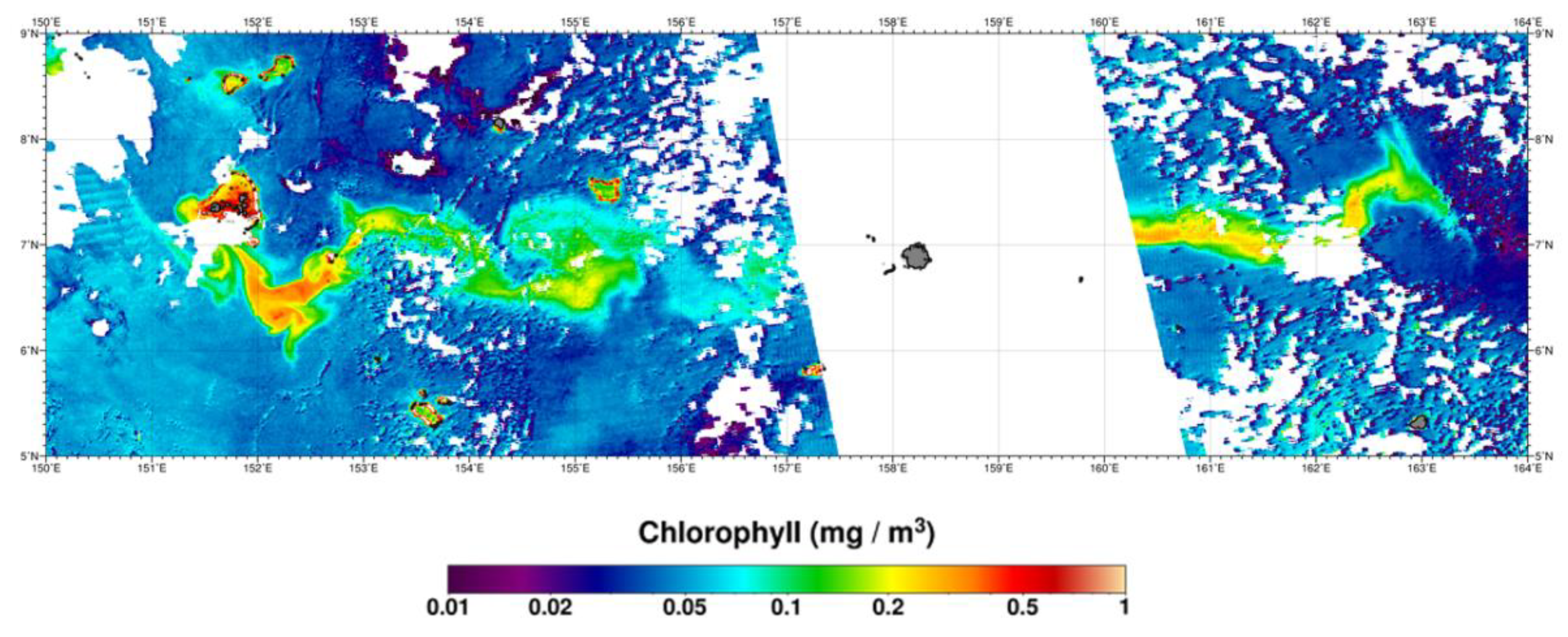
The wind variable examined from MERRA-2 was surface wind maximum speed hourly, in data product M2T1NXFLX (hourly time-averaged 2-dimensional data consisting of assimilated surface flux diagnostics). As a proxy for sea surface temperature (SST), the surface skin temperature (SSkT), time average hourly, in data product M2T1NXSLV (hourly time-averaged two-dimensional data consisting of meteorology diagnostics at popularly used vertical levels), was also examined. The spatial resolution of both data products is 0.5 × 0.625 degrees. MERRA-2 northward and eastward wind component data from data product M2I3NPASM were also used in this study.
Although MERRA-2 does not have a SST data variable, it does provide an SSkT variable. This data product is an excellent substitute for SST, because the input data for its generation is satellite-observed SST data for oceanic regions. Akella et al. (2017) [11] state that “The SST and sea ice concentration in the quasi-operational GEOS ADAS come from the Operational Sea Surface Temperature and Ice Analysis system (OSTIA; Donlon et al., 2012 [12])” [GEOS = Goddard Earth Observing System, Version 5; ADAS = Atmospheric Data Assimilation System]. Akella et al. modified the calculation of SSkT to account for the diurnal heating/cooling cycle. OSTIA, in turn, uses satellite SST input from the Group for High-Resolution SST (GHRSST). Since SSkT is based on SST data input, in this region, SSkT provides an accurate estimate of SST with hourly temporal resolution. These data are preferable to individual satellite instrument datasets, which are predominantly once or twice daily observations (such as for MODIS-Aqua), and these observations will also be affected by cloud cover obscuration. Area-averaged time series for each data variable were generated for the period 15 September–15 October 2013 for the Chuuk Lagoon region.
We also accessed historical weather observations on the website World Weather Online [13], which provide weather station observations for the island of Weno in Chuuk Lagoon. These observations are compared to the MERRA-2 wind data in the Discussion section.
MODIS-Terra and MODIS-Aqua cloud fraction data and MODIS-Aqua Photosynthetically Available Radiation (PAR) data, both available from NASA Giovanni, were used for the analysis in Section 4.4. They are provided by the Level-1 and Atmosphere Archive & Distribution System (LAADS) Distributed Active Archive Center (DAAC) and the Ocean Biology DAAC (OBDAAC), respectively.

3. Results

As described in the Introduction, a routine examination of MODIS-Aqua ocean color imagery in October 2013 revealed the presence of an elevated chl a feature extending eastward from Chuuk Lagoon and Pohnpei. The discovery image of this feature is shown in Figure 1.
The image in Figure 1 was processed from MODIS-Aqua Level 2 “satellite swath” data. The processing software was “l2gen”, which was part of the SeaDAS data processing system Version 6.4 [14]. The version of l2gen was 6.7.0. The data format was netCDF, CF-1.6.
Chuuk Lagoon, formerly and perhaps more familiarly known as Truk Atoll, is a coral atoll located in the Federated States of Micronesia (FSM). It is located at 7°25′ N, 151°47′ E in the southwestern Pacific Ocean. The encircling coral atoll has an approximate circumference of 225 km. Water depths within the lagoon can exceed 50 m, but much of the water depth lies between 10 and 25 m. Several islands are located within the atoll.
Pohnpei is the largest island in the FSM, with a central island surrounded by fringing reefs. Pohnpei is located at 6°53′ N 158°14′ E. Pohnpei is located approximately 700 km east and just slightly south of Chuuk Lagoon.
Possible causes considered for this event included the passage of a tropical cyclone near the islands, an El Nino–Southern Oscillation (ENSO) associated alteration of normal oceanic currents in the region, and an anomalous wind regime. The passage of a tropical cyclone was quickly dismissed by examination of both remote sensing data using the NASA Worldview web service [15] and by examining storm reports for 2013 from the Joint Typhoon Warning Center [16]. The closest storm in both spatial and temporal proximity to this event was Typhoon Danas, which was centered at approximately 16.5 deg N, 150.5 deg E on 2 October 2013, with approximately 30 knot winds on that date [17]. The ENSO state can be evaluated using the Oceanic Nino Index (ONI) [18]. For the entire year of 2013, the ONI was in an ENSO neutral state with values ranging from −0.4 to −0.2. An El Niño condition is indicated by values of +0.5 or higher persisting for five consecutive overlapping three-month periods, and a La Niña condition is indicated by values of −0.5 or lower persisting for five consecutive three-month periods. Due to the ENSO-neutral state, anomalous current flow in this region would not be expected.
Based on these considerations, potential causation by anomalous winds in this region was considered to be the most likely mechanism that would generate the observed chl a features. The data and methodology used to investigate such a mechanism are presented in the following discussion.
Figure 2 shows a view of conditions before the bloom, also demonstrating the normal level of cloudiness in the region, compared to a view of the region during the maximum bloom extent. Both figures were generated with NASA Giovanni using MODIS-Aqua 8-day data products, where the instrument observations are binned and averaged over 8-day intervals. Because this process uses all of the valid observations available in the time period, it usually results in a data product with reduced interference from cloud cover. During the 16-day period during which the bloom reached maximum, it was the dominant chl a signal and thus is similar to the single day image shown in Figure 1. Despite lingering effects of cloud cover, no indications of a bloom are seen in the period 6–14 September 2013.
Figure 3 shows a climatology of the region for the period 2003–2021, which also used MODIS-Aqua 8-day chl a data products.

3.1. MERRA-2 Wind Data and SSkT Data

Figure 4 is a time-series plot of the MERRA-2 surface maximum windspeed data for Chuuk Lagoon over the time period 15 September 2013 to 15 October 2013. Elevated windspeed periods occurred during 15–20 September, 26–28 September, and on 5 October, and these were sustained through 10 October. Minima occurred during 21–23 September, and 2–4 October.
Figure 5 is a time-series plot of the MERRA-2 SSkT data in the Chuuk Lagoon region over the time period 15 September–15 October 2013. Elevated temperatures are apparent during 20–24 September, 30 September–1 October, and particularly during 3–4 October, decreasing markedly on 5 October.

3.2. MERRA-2 Windspeed Variability Filter Test

Because of the importance of the variable windspeeds observed during the period prior to and during the initiation of the increased chl a, which indicated the presence of a phytoplankton bloom, we created a digital filter to examine the 40-year record of MERRA-2 surface maximum windspeed in this region. The importance of this sequence will be described in the Discussion section. The digital filter consisted of searching for these events in succession, occurring in a 20-day period:
(a)
“Trigger” event: windspeed exceeding 9 m/s;
(b)
“Sustainer” event: windspeed exceeding 8 m/s at least 5 days after the initiation “trigger” event;
(c)
“Lull/Zero” event; windspeed less than 2 m/s, with the average of the following 6 or more hours less than 1 m/s;
(d)
“Peak” event; windspeed exceeding 10 m/s. Note that the windspeed of some “Trigger” events is higher than the “Peak” event—this nomenclature was used because this event in the sequence we examined was both the highest windspeed and had a short duration.
This is the variable windspeed pattern which is observed preceding and during the phytoplankton bloom event. The filter searching for this sequence of events was applied to the area-averaged time series data for the Chuuk Lagoon region created with the NASA Giovanni system. The application of the filter to the time series data discovered 24 events in the period 1980–2019. The results are shown in Figure 6.
The discovery of 24 windspeed events matching the filter sequence indicated that the windspeed sequence was not unique in the 40-year time series. Examination of the results, however, indicated that the timing of the sequence coinciding with the phytoplankton bloom did appear unique; only five events occurred in the September–October period, and only one event, in 2013, occurred when remotely sensed ocean color data were available.
Table 1 provides the date, time, and magnitude of the “Trigger” event for each of the sequences shown in Figure 6. September–October events are emphasized with boldface. One other event occurring in August 1997 is noted; Sea-viewing Wide Field-of-view Sensor (SeaWiFS) data became available in September 1997, but examination of SeaWiFS 8-day data products in Giovanni did not indicate the presence of a bloom.
This analysis therefore engendered the question: is there a unique characteristic of the winds during the September–October period?

3.3. MERRA-2 Wind Direction Data

To address the uniqueness question raised by the digital filter test, the MERRA-2 northward and eastward wind component data (M2I3NPASM) were examined with area-averaged time series data plots created for the Chuuk Lagoon region, also using the Giovanni system. The results of this examination are displayed in Figure 7. The data examined in these plots are the eastward and northward instantaneous wind at 3-hourly temporal resolution for the near surface 950 hPA pressure layer (this is an atmospheric profile data product with data available for atmospheric pressures from 1000 to 1 hPA). The data were plotted for the period January 2012–December 2015.
These plots revealed that the region does experience an apparent cyclic seasonal pattern in both the eastward and northward wind components. With positive values indicating eastward and northward directed winds, it is notable that mid-year (approximately August–November) is the period where eastward and northward wind dominates, and this was particularly notable for the eastward component in September–October 2013. The primary period when both the eastward and northward winds dominate at the same time appears more temporally constrained.
To confirm the seasonal pattern shown in Figure 7, the time period was extended one year, and the seasonality is also apparent in 2015. However, there is more variability in 2015. Given that this period coincides with the commencement of the strong 2015–2016 El Nino–Southern Oscillation event, the higher variability may be related to this. In 2013, both the northward and eastward component tendencies (i.e., winds directed north and east) were more tightly clustered in the September–October time period than prior or subsequent years. This is better visualized with a three-year rather than a four-year time period.
The last results presented in this section prior to the Discussion are the northward and eastward winds for the period examined earlier, when the unique phytoplankton bloom was observed, in September–October 2013. These results are shown for the Chuuk Lagoon region in Figure 8, extended to October 30, to show the winds for the full duration of the bloom. The complete time sequence of the bloom will be presented in the Discussion section.

4. Discussion

4.1. Description of Wind Event Sequence

The previous section described the results of our examination of windspeed and wind direction data during the period when the unusual phytoplankton bloom in and adjacent to Chuuk Lagoon took place. The following discussion describes the sequence of events and their causal significance.
As discussed in the Introduction, increased windspeed over the ocean is known to cause water column mixing, which commonly results in nutrient transport from subsurface waters to the surface. These increased surface nutrient concentrations can foster increased phytoplankton productivity and may trigger blooms. The mechanism has been described for both seasonally episodic events and for anomalous events, as shown by the references in the Introduction. Hurricanes and cyclones are also known to mix deep waters to the surface, resulting in higher chromophoric matter concentration and chl a in storm wakes [19].
Chuuk Lagoon is surrounded by oligotrophic waters, but even oligotrophic waters will have increased nutrient concentrations at depths below the surface due to ongoing biological productivity and the remineralization of organic matter. Although the increased concentrations at shallow depths may be modest, they will normally still exceed surface concentrations and thus may be utilized when wind action brings them to the surface [20,21].
For the October 2013 bloom event, we observed a period of increased windspeed with northeastward winds of approximately 9–10 m/s from 18 to 20 September. Note that the actual windspeed may have been higher, as averaging and temporal resolution will generally reduce maximum values of remotely sensed data compared to in situ observations. We refer to this event as the “Trigger” event possessing sufficient energy to mix the water column and transport nutrients to the surface. SSkT data decreased during this period, supporting the likelihood of mixing. During the following period, as winds abated, SSkT increased, allowing stratification.
The cooling observed on the 15th and 16th (Figure 5) was due to the elevated windspeed of the “Trigger” event, and as the windspeed subsided, the lagoon waters warmed under low mixing conditions, which is consistent with the increased amplitude of the diurnal cycles after September.
From 26 to 28 September, the region experienced another elevated windspeed period, with MERRA-2 maximum surface windspeed exceeding 8 m/s. We refer to this period as the “Sustainer” event, as the magnitude and duration again would have mixed the water column. SSkT declines at this time. During this period, it is important to note that the wind direction was predominantly eastward. Examination of MODIS-Aqua ocean color data on the NASA Worldview site [8] indicated diffuse elevated chl a (0.2–0.3 mg/m3) east of Chuuk Lagoon on 28 September, indicating that the water column was in a state that encouraged phytoplankton growth.
The most important factor in the “Sustainer” period is the increasing windspeed trend commencing on the 24th, ebbing slightly, and then reaching its maximum on 26–27 September. The minimum SSkT occurs nearly simultaneously.
From 29 September through 5 October, the Chuuk Lagoon region experienced very low windspeeds, including a near-zero windspeed interval on 3 October. The accuracy of the MERRA-2 data at this time was confirmed by the World Weather Online website [13], as shown in Table 2. SSkT increases by almost a degree K during this period, which is clearly seen in Figure 4. We refer to this as the “Lull/Zero”event—a period when surface stratification would have been promoted, thus allowing the growing phytoplankton population stimulated by the previous events to fully utilize increased nutrient concentrations provided by wind mixing, creating ideal conditions for a bloom. Note that Furnas et al. [7] indicated that blooms developed in Great Barrier Reef lagoons during intermittent calm periods, which are analagous to the calm period occurring at Chuuk Lagoon on 3 October.
As windspeed accuracy is important to this analysis, we consulted an evaluation of the MERRA-2 reanalysis dataset published by the Goddard Modeling and Assimilation Office (GMAO) [22], which produces the dataset. They indicate that MERRA-2 windspeeds compare most closely to the Cross-Calibrated Multi-Platform (CCMP) Ocean Surface Wind Vector L2.5A Monthly Analyses available from the Physical Oceanography Distributed Active Archive Center of the NASA Jet Propulsion Laboratory, with a mean difference of only 0.05 m/s. They also state that MERRA-2 winds are weaker than surface observations, which would indicate that the windspeed data used for our analysis were lower than the actual windspeeds. Higher windspeeds would provide more energy for mixing deeper in the water column. A more detailed physical oceanographic analysis of events could provide more information on wind forcing; for the purpose of identifying the potential causal wind pattern, MERRA-2 wind data should be sufficient.
The final event, which we have termed the “Peak” event, occurred primarily on 5 October. Although the digital filter used a 10 m/s criterion, the MERRA-2 surface maximum windspeed actually reached 14 m/s, which was accompanied by a marked reduction in SSkT (World Weather Online [13] indicates gusts to 40 km/h, ≈11 m/s, during this period). The winds declined from maximum values in the following days, but they still continued to be directed northeastward (with the eastward component somewhat larger than the northward component) until 9 October.
Figure 9, Figure 10 and Figure 11 provide spatial context for each of the four sequential events we have described. These time-averaged maps were generated with NASA Giovanni. The surface maximum wind speed, the eastward instantaneous wind, and the northward instantaneous wind are shown for each event.
Figure 12 provides maps of the SSkT minimum on 27 September at 23:00 Z, and the SSkT maximum on 3 October, also at 23:00 Z.
The subsequent observation of the narrow extended plume of elevated chl a on 12 October is therefore explained as the result of alternate water column mixing and stratification events during specific wind direction conditions, which were followed by a period of wind transport that extended the plume eastward toward Pohnpei. Stratification would have been augmented by the likely very calm conditions within the Chuuk Lagoon geological boundaries during the “Lull/Zero” event period. Although Pohnpei does not have a lagoon such as Chuuk Lagoon, it too likely experienced the alternating windspeeds, and the island itself could have also enhanced the bloom due to the “island mass effect”, which will be described below.

4.2. Duration of Bloom

To determine the full duration of the bloom, from approximate initiation to approximate termination, we used NASA Worldview to look at the available MODIS-Aqua daily ocean color data. There is no indication of higher chl a outside of the lagoon on 9 September, which provides a clear view. (Also refer to the top panel of Figure 2.) A partial view on 21 September, which was subsequent to the “Trigger” event, indicates a small area of higher chl a quite near to the lagoon. On 28 September, subsequent to the “Sustainer” event, an area of higher chl a is located east of the lagoon, which is also visible on 30 September and 3–4 October. No other clear views are available until 12 October, when the entire feature is visible.
Following the observations of 12 and 13 October, a small area of elevated chl a is visible east of Chuuk Lagoon on 19 October and also on 30 October. A fainter area can be seen on 6 November, and slightly elevated chl a is apparent over a wide area on 10 November. Figure 8 shows that by the end of October, southward and westward winds became dominant.
Intriguingly, the region was affected during this period by the tropical system which would become Super Typhoon Haiyan, which made its closest approach to Chuuk Lagoon on 4 November and was a strong storm system west of the lagoon on 5 November. Thus, any remaining connection to the early October events would have been significantly disturbed by the effects of Haiyan following its passage.

4.3. Significance of Wind Direction

Now that the temporal sequence of events contributing to both bloom and plume formation has been described, an important remaining topic is the significance of wind direction. As has been shown, the uniqueness of this event is related to both the alternating elevated and low windspeeds, occurring during a period in which northeastward winds dominated, which is a wind direction unlike that which occurs over most of the other months of the year.
Figure 13 is a MODIS-Terra image of Chuuk Lagoon, which was acquired under nearly cloud-free conditions on 29 March 2013. Figure 14 displays a bathymetric map of the lagoon and adjacent ocean, which was acquired from the Digital Atlas of Micronesia [23]. The image and maps (and other available imagery and maps) indicate that the island and reef boundary of Chuuk Lagoon on the southwest and west side is considerably more open to the ocean than the north and east sides of the lagoon. Therefore, winds blowing northward and eastward are considerably more capable of transporting open ocean water from outside the lagoon boundary into the lagoon compared to winds blowing southward and westward. This observation supports our proposed mechanism for the formation of the unique October 2013 bloom.
The “Trigger” event wind direction was northeastward, which would have transported open ocean waters into the lagoon from the southwest. The “Sustainer” event wind direction was primarily eastward, so that open ocean waters could enter the lagoon through the gap on the western side. During the “Lull/Zero” period, the wind direction of any low windspeed winds was actually southward, with virtually no eastward component, until northward windspeed began to increase after 3 October to the “Peak” event windspeed on 5 October, during which the winds were again directed north and east.
The wind directions occurring during this period would therefore first transport waters from the mixed water column with increased nutrient concentrations into the lagoon. The next step was low wind conditions enhancing stratification and encouraging bloom development, along with wind directions that may have gently moved lagoon waters with elevated phytoplankton population out of the lagoon, although not far. The final step was the creation of the narrow plume of increased chl a by the elevated and sustained northeastward winds.
One other aspect of this event concerns the values of the observed chl a in the plume. Compared to seasonal blooms such as the North Atlantic Bloom, or concentrations in upwelling zones such as the Benguela or Peru upwelling zone, or for the episodic winter wind-mixed events off the western coast of Central America where windspeeds can approach hurricane force, the maximum concentrations observed in this plume are much lower. Even though the plume concentrations are considerably higher than normal oligotrophic values, which generally range from lower than 0.1 mg/m3 to the detectable minimum, the chl a values in the plume do not indicate a large phytoplankton population. These chl a values are consistent with a modestly elevated nutrient supply from shallow depths in the water column that did not persist for a long period of time.
Support for the wind-mixing mechanism as the cause of the event is found in Kahru et al., 2010 [24]. These authors examined winds, chl a, and SST over the global oceans. The authors state, “The correlation between chl-a and wind speed is generally negative in areas with deep mixed layers and positive in areas with shallow mixed layers.” As the western tropical Pacific is primarily an area with low windspeeds and thus a shallow mixed layer, this statement applies to the Micronesia region. Figure 1a in Kahru et al. shows a global map of the oceans with areas of positive and negative correlation between monthly windspeed anomalies and chl a, and Micronesia is a region of positive correlation. More significantly, Figure 3a of Kahru et al. clearly shows Chuuk Lagoon in a region of high correlation between positive chl a anomalies and positive eastward wind pseudostress anomalies, which accords with our observations of the MERRA-2 wind directions in the period preceding the observation of the October 2013 chl a plume. Although Kahru et al. define positive chl a anomalies as values that exceed mean chl a values, because the elevated concentrations seen in the October 2013 event are substantially higher than the mean for the region (refer to Figure 3), this event would appear to be consistent with the definition of Kahru et al.
Because the plume observed in October 2013 was also seen extending to and past Pohnpei island, east of Chuuk Lagoon, the presence of this island may have enhanced the bloom due to the well-known “island mass effect”. Winds blowing consistently in the northeastward direction for a few days would have induced a surface current that would have encountered the Pohnpei island platform. This interaction would induce the subsurface current flow to shoal toward the surface, perhaps with more nutrients to sustain an increased phytoplankton population. Island mass effect chl a enhancements are observed in several archipelagic locations and have been characterized with remote sensing [25,26,27,28].
It is possible that both the Chuuk Lagoon chl a plume and the Pohnpei chl a plume are attributable to the island mass effect. However, the extreme calm period of winds, in combination with an increased nutrient concentration, would have provided ideal conditions for enhanced phytoplankton growth within the lagoon. These factors lead to our conclusion that the bloom reached its maximum within the lagoon, and the waters with elevated phytoplankton concentration were transported out of the lagoon by the elevated windspeed event on the 5 October. In addition, while not conclusive, an association of the lagoon and the chl a plume is suggested by the morphology of the highest chl a waters adjacent to the lagoon on 12 October.

4.4. Examination of Cloud Cover

In the course of manuscript revisions, it was noted that due to the shallowness of the waters in Chuuk Lagoon, phytoplankton growth will not be light-limited. This led to the consideration that another factor affecting bloom development could have been cloud cover over the region. In this tropical region, the primary influence on light availability will be cloud cover. A brief examination of MODIS cloud fraction data provided interesting results. Adrea-averaged time-series of MODIS-Terra and MODIS-Aqua daily daytime cloud fraction were plotted with NASA Giovanni for the same region used in Figure 9, Figure 10 and Figure 11 (Figure 15). MODIS-Terra has a mid-morning local time equatorial crossing time, and MODIS-Aqua has an early afternoon local time equatorial crossing time, so the daytime cloud fraction may be slightly higher for MODIS-Aqua.
Both plots show the same basic pattern. During the period we have indicated for wind mixing, commencing on 16 September and continuing to 28 September, the daytime cloud fraction was high, ranging from 70 to 100%. During the lull period we have suggested was conducive to phytoplankton growth, the cloud fraction decreases markedly, to a minimum below 50%. As would be expected, the cloud fraction also reaches a minima when the elevated chl a feature was observable, just prior to 15 October.
To further evaluate this factor, we also plotted MODIS-Aqua 8-day Photosynthetically Available Radiation (PAR) data against the MODIS-Aqua cloud fraction data shown in Figure 15. This plot (Figure 16) supports the description above. The period with the highest cloud fraction values, 16–28 September, also has significantly reduced PAR. During the following three 8-day periods, including the period when the high chl a plume was visible on 12 October, PAR increased. These higher PAR values are consistent with the lower cloud fraction values occurring in late September through mid-October.
These data suggest that during the wind-mixing period, phytoplankton growth would have been inhibited by reduced PAR. During the lull period, the effects of stratification and higher nutrient availability could have been enhanced by increased solar radiation, promoting phytoplankton growth. Increased PAR would also have maintained phytoplankton growth during the days prior to when the feature was observed.
The growth of photosynthesizing phytoplankton benefits from the increased availability of solar radiation. When other factors are favorable for a phytoplankton bloom, decreased solar radiation at the ocean surface can delay the development of a bloom, as Acker et al., 2006 [29] showed for a delayed development of the North Atlantic Bloom near Newfoundland due to higher than average spring cloud cover in 2003. The MODIS-Terra cloud fraction data and the MODIS-Aqua cloud fraction and PAR data shown here indicate that cloud cover and its effect on PAR before and during the bloom period were likely a contributing factor to the unique conditions inducing this event.

5. Conclusions

Phytoplankton blooms initiated and sustained by nutrients provided by wind mixing have been commonly observed well before the era of satellite remote sensing. Satellite remote sensing provided much more extensive global coverage and many more examples of this common process. For the case examined in this paper, ocean color remote sensing enabled the observation of a singular bloom that might otherwise have gone unnoticed and unremarked. We have shown that the singular nature of this bloom likely resulted from a unique and fortuitous combination of alternating, days-long elevated and low windspeed events and seasonally occurring wind directions, which were accompanied by sufficient light availability. This combination created ideal conditions for the development of a phytoplankton bloom in a region where phytoplankton blooms are exceedingly rare.
Our investigation of this event was constrained by the availability of observations and related modeling; the available data resources still provided sufficient data to elucidate a likely sequence of causation. Further investigation could involve modeling the physical oceanographic aspects of this event, or any similar events, if such could be discovered. While such modeling might be of interest, it would not be likely to produce much additional insight, as the effect of wind mixing on the chemistry and biology of the surface ocean is already well established. Furthermore, because of the demonstrated rarity of events such as this, obtaining any in situ verification data would be problematic. Therefore, the use and analysis of remotely sensed data variables provides the most fruitful method for investigating nature’s remarkable surprises such as this.

Author Contributions

Formal analysis, A.H.; Investigation, J.A. and N.K.; Methodology, J.A., A.H. and N.K.; Visualization, J.A., A.H. and N.K.; Writing—original draft, J.A. J.A. authored the manuscript, and created the time-series data plots with Giovanni, and other graphic images. A.H. analyzed the downloaded MERRA-2 surface maximum windspeed data with the digital filter described in the manuscript. N.K. processed MODIS-Aqua remotely-sensed ocean color data to create Figure 1 and provided context on the image creation and the observation of the event. All authors have read and agreed to the published version of the manuscript.

Funding

This research received no external funding.

Data Availability Statement

The data used in this study are available from the NASA Goddard Earth Sciences Data and Information Services Center (GES DISC) archive (https://disc.gsfc.nasa.gov, accessed on 11 July 2022 and they are also resident in the Giovanni analysis system (https://giovanni.gsfc.nasa.gov, accessed on 11 July 2022. The data used for Figure 1 are available from the Ocean Biology Distributed Active Archive Center (OBDAAC), https://oceancolor.gsfc.nasa.gov/, accessed on 11 July 2022 and are also resident in the Giovanni analysis system. Dataset DOIs for the data used in this study: M2T1NXFLX: 10.5067/7MCPBJ41Y0K6; M2T1NXSLV: 10.5067/VJAFPLI1CSIV; M2I3NPASM: 10.5067/QBZ6MG944HW0; MODIS-Terra and MODIS-Aqua Cloud Fraction: 10.5067/MODIS/MOD08_M3.006 (Terra); 10.5067/MODIS/MYD08_M3.006 (Aqua); MODIS-Aqua Chlorophyll: 10.5067/AQUA/MODIS/L3B/CHL/2018; MODIS-Aqua PAR: 10.5067/AQUA/MODIS/L3B/PAR/2018.

Acknowledgments

The authors wish to thank R. Jude Wilber for insightful comments on an earlier version of the manuscript; the staff of the Ocean Biology Distributed Active Archive Center (OBDAAC) for providing NASA ocean color data and supporting information; the NASA personnel of the Global Modeling and Assimilation Office at Goddard Space Flight Center who have created the MERRA-2 dataset; and the GES DISC Giovanni development staff.

Conflicts of Interest

The authors declare no conflict of interest.

References

  1. Behrenfeld, M.J.; Boss, E.S. Student’s tutorial on bloom hypotheses in the context of phytoplankton annual cycles. Glob. Change Biol. 2018, 24, 55–77. [Google Scholar] [CrossRef] [PubMed]
  2. Brenes, C.L.; Coen, J.E.; Chelton, D.B.; Enfield, D.B.; Leon, S.; Ballestero, D. Wind driven upwelling in the Gulf of Nicoya, Costa Rica. Int. J. Remote Sens. 2003, 24, 1127–1133. [Google Scholar] [CrossRef]
  3. Kubryakov, A.A.; Zatsepin, A.G.; Stanichny, S.V. Anomalous summer-autumn phytoplankton bloom in 2015 in the Black Sea caused by several strong wind events. J. Marine Sys. 2019, 194, 11–24. [Google Scholar] [CrossRef]
  4. Stanichny, S.V.; Kubryakova, E.A.; Kubryakov, A.A. Quasi-tropical cyclone caused anomalous autumn coccolithophore bloom in the Black Sea. Biogeosciences 2021, 18, 3173–3188. [Google Scholar] [CrossRef]
  5. Chow, C.H.; Cheah, W.; Tai, J.-H.; Liu, S.-F. Anomalous wind triggered the largest phytoplankton bloom in the oligotrophic North Pacific Subtropical Gyre. Sci. Rep. 2019, 9, 11. [Google Scholar] [CrossRef]
  6. Chen, X.; Pan, D.; Bai, Y.; He, X.; Chen, C.-T.A.; Hao, Z. Episodic phytoplankton bloom events in the Bay of Bengal triggered by multiple forcings. Deep Sea Res. Part I Oceanogr. Res. Pap. 2013, 73, 17–30. [Google Scholar] [CrossRef]
  7. Furnas, M.J.; Mitchell, A.W.; Gilmartin, M.; Revelante, N. Phytoplankton biomass and primary production in semi-enclosed reef lagoons of the central Great Barrier Reef, Australia. Coral Reefs 1990, 9, 1–10. [Google Scholar] [CrossRef]
  8. Gelaro, R.; McCarty, W.; Suarez, M.J.; Todling, R.; Molod, A.; Takacs, L.; Randles, C.A.; Darmenov, A.; Bosilovich, M.G.; Reichle, R.; et al. The Modern-Era Retrospective Analysis for Research and Applications, Version 2 (MERRA-2). J. Clim. 2017, 30, 5419–5454. [Google Scholar] [CrossRef] [PubMed]
  9. NASA. Geospatial Interactive Online Visualization ANd aNalysis Infrastructure (Giovanni). Available online: https://giovanni.gsfc.nasa.gov (accessed on 15 June 2022).
  10. McCarty, W.; Coy, L.; Gelaro, R.; Huang, A.; Merkova, D.; Smith, E.B.; Sienkiewicz, M.; Wargan, K. MERRA-2 Input Observations: Summary and Assessment; Technical Report Series on Global Modeling and Data Assimilation; NASA/TM–2016-104606/; Randal, D.K., Ed.; NASA: Greenbelt, MD, USA, 2016; Volume 46, p. 64.
  11. Akella, S.; Todling, R.; Suarez, M. Assimilation for skin SST in the NASA GEOS atmospheric data assimilation system. Q. J. R. Meteorol. Soc. 2017, 143, 1032–1046. [Google Scholar] [CrossRef] [PubMed]
  12. Donlon, C.J.; Martin, M.; Stark, J.; Roberts-Jones, J.; Fiedler, E.; Wimmer, W. The operational sea surface temperature and sea ice analysis (OSTIA) system. Remote Sens. Environ. 2012, 116, 140–158. [Google Scholar] [CrossRef]
  13. World Weather Online. Available online: https://www.worldweatheronline.com/ (accessed on 24 June 2022).
  14. SeaDAS: The Official NASA/OB.DAAC Data Analysis Software. Available online: https://seadas.gsfc.nasa.gov/ (accessed on 26 August 2022).
  15. NASA Worldview. Available online: https://worldview.earthdata.nasa.gov (accessed on 23 August 2021).
  16. Joint Typhoon Warning Center. Available online: https://www.metoc.navy.mil/jtwc/jtwc.html (accessed on 19 July 2021).
  17. Joint Typhoon Warning Center Annual Tropical Cyclone Report 2013, “Typhoon Danas”, Page 39. Available online: https://www.metoc.navy.mil/jtwc/products/atcr/2013atcr.pdf (accessed on 19 July 2021).
  18. National Weather Service Climate Prediction Center, “Cold and Warm Episodes by Season”. Available online: https://origin.cpc.ncep.noaa.gov/products/analysis_monitoring/ensostuff/ONI_v5.php (accessed on 19 July 2021).
  19. Acker, J.; Lyon, P.; Hoge, F.; Shen, S.; Roffer, M.; Gawlikowski, G. Interaction of Hurricane Katrina with optically complex water in the Gulf of Mexico: Interpretation using satellite-derived inherent optical properties and chlorophyll concentration. IEEE Geosci. Rem. Sens. Lett. 2009, 6, 209–213. [Google Scholar] [CrossRef]
  20. Sunda, W. Feedback interactions between trace metal nutrients and phytoplankton in the ocean. Front. Microbiol. 2012, 3, 1–22. [Google Scholar] [CrossRef] [PubMed]
  21. Bif, M.B.; Siqueira, L.; Hansell, D.A. Warm events induce loss of resilience in organic carbon production in the northeast Pacific Ocean. Glob. Biogeochem. Cycles 2019, 33, 1174–1186. [Google Scholar] [CrossRef]
  22. Bosilovich, M.G. MERRA-2: Initial Evaluation of the Climate. NASA/TM2015104606. 2015; Volume 43, p. 139. Available online: https://gmao.gsfc.nasa.gov/pubs/docs/Bosilovich803.pdf (accessed on 11 August 2022).
  23. Image of Chuuk Lagoon, Used Under a Creative Commons License Granted by Island Research & Education Initiative (iREi) and Water and Environmental Research Institute of the Western Pacific (WERI). The Dataset was Extracted from the 2020 General Bathymetric Chart of the Oceans (GEBCO) by the GEBCO Compilation Group (2020) as Part of the Seabed 2030 Project. Known as the GEBCO 2020 Grid, this is a Continuous Terrain Model for Ocean and Land with a Spatial Resolution of 15 Arc Seconds. It is an Updated Version of Previous GEBCO Grids, First Published in January 2009. Island Research & Educa-tion Initiative (iREi) (2020) Extracted a Subset of the Original Dataset and Formatted it for Use in this Atlas. Available online: https://islandatlas.org/chuuk/reefs/ (accessed on 26 August 2022).
  24. Kahru, M.; Gille, S.T.; Murtugudde, R.; Strutton, P.G.; Manzano-Sarabia, M.; Wang, H.; Mitchell, B.G. Global correlations between winds and ocean chlorophyll. J. Geophys. Res. Atmos. 2010, 115, 1–11. [Google Scholar] [CrossRef]
  25. Wolanski, E.; Colin, P.; Naithani, J.; Deleersnijder, E.; Golbuu, Y. Large amplitude, leaky, island-generated, internal waves around Palau, Micronesia. Estuar. Coast. Shelf Sci. 2004, 60, 705–716. [Google Scholar] [CrossRef]
  26. Simpson, J.H.; Tett, P.B. Island stirring effects on phytoplankton growth. In Tidal Mixing and Plankton Dynamics; Bowman, J., Yentsch, M., Peterson, W.T., Eds.; Springer: Berlin, Germany, 2012; Volume 17, pp. 41–77. [Google Scholar]
  27. Simpson, J.H.; Tett, P.B.; Argotte-Spinoza, M.L.; Edwards, M.; Jones, K.J.; Savidge, G. Mixing and phytoplankton growth around an island in a stratified sea. Cont. Shelf Res. 1982, 1, 15–31. [Google Scholar] [CrossRef]
  28. Messié, M.; Petrenko, A.; Doglioli, A.M.; Martinez, E.; Alvain, S. Basin-scale biogeochemical and ecological impacts of islands in the tropical Pacific Ocean. Nat. Geosci. 2022, 15, 469–474. [Google Scholar] [CrossRef]
  29. Acker, J.; Spatial and Temporal Coherence of SeaWiFS Chlorophyll Concentration Anomalies in the North Atlantic Bloom (1998–2005) Examined with Giovanni. Proc. Amer. Geophysical Union Spring Meeting, Baltimore, Maryland. 2006. Available online: https://docserver.gesdisc.eosdis.nasa.gov/public/project/publications/01_jan06_AGU_2006_poster_anomalies_1_acker.jpg (accessed on 26 August 2022).
Figure 1. MODIS-Aqua false color image of Chuuk Lagoon and the oceanic region to the east, which was acquired on 12 October 2013. The island of Pohnpei was located in the MODIS instrument scanning swath gap on 12 October. The highest chl a (0.4–0.5 mg/m3) is located southeast of Chuuk Lagoon, and a plume of elevated chl a is observed extending eastward from both Chuuk Lagoon and past Pohnpei. The boundaries of the region shown are 150–164° E, 5–9° N.
Earth 03 00056 g001
Figure 2. Comparison of MODIS-Aqua 8-day chl a data visualized with NASA Giovanni. (top) Time period of 6–14 September 2013. (bottom) Time period of 8–24 October 2013. Chuuk Lagoon as located at the northeastern corner of each image, and Pohnpei is approximately centered. The color scale is from 0.08 to 1.0 mg m−3. The boundaries of these images are 151.2–163.2° E, 6–8° N.
Earth 03 00056 g002
Figure 3. MODIS-Aqua chl a climatology for the Chuuk Lagoon-Pohnpei region (151.2° E, 6° N, 163.2° E, 8° N) for the period 2003–2021. As is expected for an oligotrophic ocean waters, chl a is normally very low.
Earth 03 00056 g003
Figure 4. MERRA-2 surface maximum windspeed data for Chuuk Lagoon for the period 15 September–15 October 2013. The selected region was defined by 151.5–152.2° E, 7.0–7.7° N.
Earth 03 00056 g004
Figure 5. Time series of MERRA-2 SSkT data for the Chuuk Lagoon region for the period 15 September–15 October 2013. The regional boundaries used to generate this plot are the same as for Figure 4.
Earth 03 00056 g005
Figure 6. Digital filter results for the 40-year time series (1980–2019) of MERRA-2 surface maximum windspeed data for the Chuuk Lagoon region. The colored dots show the sequence of events which was searched, consisting of (green) trigger event, (blue) sustaining event, (black) lull event, and (red) transport event.
Earth 03 00056 g006
Figure 7. (top) MERRA-2 instantaneous eastward wind and (bottom) instantaneous northward wind for the Chuuk Lagoon region, at the 950 hPA pressure layer, 3-hourly temporal resolution, for the period January 2012–December 2015. The region used for these figures was 149–154.2° E, 6.0–8.0° N.
Earth 03 00056 g007
Figure 8. (top) MERRA-2 surface maximum windspeed (center) instantaneous eastward wind and (bottom) instantaneous northward wind for the Chuuk Lagoon region. The eastward and northward wind data are for the 950 hPA pressure layer. The time period is 15 September 2013 to 30 October 2013. The boundaries of the region used for this plot are 151.0–152.5° E, 6.7–8.2° N.
Earth 03 00056 g008
Figure 9. Time-averaged maps of MERRA-2 surface maximum windspeed for the four events of the wind sequence described for the October 2013 bloom event. The location of Chuuk Lagoon is indicated with the arrow. The region shown is 145–160° E, 5–10° N. Units are m/s.
Earth 03 00056 g009
Figure 10. Time-averagedmaps of MERRA-2 instantaneous eastward wind for the four events of the wind sequence described for the October 2013 bloom event. The location of Chuuk Lagoon is indicated with the arrow. The region shown is 145–160° E, 5–10° N. Units are m/s.
Earth 03 00056 g010
Figure 11. Time-averagedmaps of MERRA-2 instantaneous northward wind for the four events of the wind sequence described for the October 2013 bloom event. The location of Chuuk Lagoon is indicated with the arrow. The region shown is 145–160° E, 5–10° N. Units are m/s.
Earth 03 00056 g011
Figure 12. Time-averaged maps of MERRA-2 SSkT created with NASA Giovanni. (top) Minimum SSkT occurring on 27 September 2013, 23:00 Z. (bottom) Maximum SSkT occurring on 3 October 2013, 23:00 Z. The color scale is from 302 to 304 Kelvin (28.85–30.85 °C).
Earth 03 00056 g012
Figure 13. MODIS-Terra snapshot image of Chuuk Lagoon, acquired on 29 March 2013. (North is at the top.) The snapshot was downloaded from the NASA Worldview web service [8] at 250 m resolution. The southern and eastern sides of the lagoon are open to the adjacent ocean waters, while the island and reef boundary is thicker and more contiguous on the northern and western sides.
Earth 03 00056 g013
Figure 14. (top) Bathymetric map of Chuuk Lagoon and surrounding waters [23]. This map is shown much smaller than full size; at full size, available at https://islandatlas.org/chuuk/reefs/ (accessed on 26 August 2022), it confirms the locations of the reefs of the atoll and the gaps between reefs that are apparent in the MODIS image shown in Figure 14. (bottom) Subset image from the full-size bathymetric map, showing the bathymetry on the west side of Chuuk Lagoon. White areas are atoll reefs.
Earth 03 00056 g014
Figure 15. Time series of (top) MODIS-Terra and (bottom) MODIS-Aqua daily daytime cloud fraction for the period August–September 2013 for the region 145–160° E, 5–10° N.
Earth 03 00056 g015
Figure 16. Time-series plot of daily MODIS-Aqua cloud fraction (blue) and MODIS-Aqua 8-day PAR for the Chuuk Lagoon region. This plot shows that the period of higher cloud cover from mid- to late September 2013 coincided with a period of lower PAR, and the periods of lower cloud cover in early- to mid-October coincided with higher PAR values. Units of PAR are Einstein/m2/day; cloud fraction is unitless from 0 to 1 (0% to 100% cloud cover).
Earth 03 00056 g016
Table 1. Start date and trigger event wind speed for each of the identified windspeed sequences displayed in Figure 6.
Start DateTrigger Wind Speed (m/s)
15 Jun 1982 20:3010.5
15 Oct 1983 15:309.4
23 Aug 1986 0:309.4
7 Sep 1991 13:309.6
1 Nov 1992 1:3013.2
1 Mar 1993 8:3010.8
15 Oct 1994 3:309.3
9 Dec 1994 20:3010.2
12 Nov 1995 16:309.2
8 Mar 1997 20:309.2
20 Aug 1997 14:309.2
8 Dec 2001 12:309.5
1 Feb 2004 21:309.0
13 Mar 2004 2:3010.9
7 Apr 2004 23:309.0
8 Jun 2004 10:309.0
2 Jan 2005 17:3010.2
16 Sep 2013 8:309.1
10 Jan 2014 11:309.1
10 Jun 2015 8:3010.4
28 Jan 2017 0:309.3
19 Nov 2018 19:309.6
3 Jun 2019 07:3010.3
22 Nov 2019 18:309.5
Table 2. Historical weather data from for 3 October 2013, for Weno Island, Chuuk Lagoon, from World Weather Online (https://www.worldweatheronline.com/weno-weather-history/chuuk/fm.aspx accessed on 26 August 2022). The period of low windspeed indicated by the MERRA-2 surface maximum windspeed data is supported by these observations, where the windspeed is shown as 1 km/h (0.3 m/s) with gust speed to 2 km/h (0.6 m/s) at 1800 local time.
Local TimeAverage Wind Speed (km/h: m/s)Gust Speed
(km/h: m/s)
00006: 1.79: 2.5
03007: 1.910: 2.8
060013: 3.625: 6.9
09004: 1.15: 1.4
12004: 1.15: 1.4
15003: 0.84: 1.1
18001: 0.32: 0.6
21004: 1.16: 1.7
Publisher’s Note: MDPI stays neutral with regard to jurisdictional claims in published maps and institutional affiliations.

