Article

Landscape Assessment Methods Derived from the European Landscape Convention: Comparison of Three Spanish Cases

Department of Architectural Composition, Escuela Tecnica Superior de Arquitectura de Madrid, Universidad Politécnica de Madrid, 28040 Madrid, Spain
Earth 2022, 3(2), 522-536; https://doi.org/10.3390/earth3020031
Submission received: 13 February 2022 / Revised: 12 March 2022 / Accepted: 21 March 2022 / Published: 23 March 2022

Abstract

:
The implementation of the European Landscape Convention (ELC) at national and regional scales has brought with it the need to rethink landscape governance policies. In view of the disparity of possible methods for approaching landscape knowledge derived from the ELC, this article proposes the study of the three most ambitious landscape assessment methods developed in Spain at present. Specifically, those of Valencia, Galicia and Catalonia. Their study and comparative reading allow us to conclude that they have a similar structure imposed in part by the requirements of the Convention. Despite this, all three demonstrate a wide operational flexibility depending on the purpose of each one. As a derivative of the study, it is argued that a method seeking to fulfill both a sustainability and a public participation agenda would have to combine quantitative forms of socio-ecological assessment with a qualitative measurement of cultural appreciation of landscapes.

1. Introduction

At the end of the 20th century, important changes in the intellectual position regarding the notion of landscape crystallized in various safeguard initiatives [1,2]. Among them, the European Landscape Convention (ELC) [3], signed in 2000 and currently implemented to a greater or lesser extent by most of the member states of the Council of Europe [4], stands out. The ELC has been a definitive step towards the union between landscape, cultural identity and governance [5,6,7]. As a result, the legal systems currently in place have been examined recently to align them with the principles of the ELC [8,9,10,11]. Even so, the Convention has multiple facets beyond the normative, as it concerns the field of landscape ecology and cultural heritage, as well as the role of the local in a globalized era [12]. According to the Council of Europe, currently 40 countries have signed and ratified the Convention, with only one, Malta, having signed but not ratified. Notable absences of signatures include countries such as Germany or Austria [13]. Many of them have also implemented legal measures in line with the Commission’s ideas, although, in some cases, with certain territorial limitations. This is the case with Denmark, which declared that it would not apply the Convention in the Faroe Islands and Greenland [14].
The conceptual complexity of ELC makes it difficult to implement through the modification of existing laws and requires the development of more complex mechanisms for landscape management [6,15]. This poses a challenge for administrations, forced to seek management mechanisms beyond traditional conservation laws. That is, a change from landscape preservation laws to one of landscape governance actions [16]. Beyond the normative, it is necessary to define methods related to the deep knowledge of the lived environment and, above all, of the way in which it is perceived by the population [17]. Cultural differences between countries and regions open a wide range of possible responses to the problem. Thus, France, Italy, Switzerland, the Netherlands, Poland and Sweden, among others, have opted for dissimilar solutions to address landscape governance. In some cases, they have enforced national plans, as is the case with Spain [18] and Italy [19]. These countries, and others, have also elaborated specific laws, inventories, regional plans, manifestos, character assessment operations and catalogs [7]. Typically, a combination of several of these actions has been developed. For example, in the Netherlands, the government has passed an Environment and Planning Act, and at the same time, a manifesto has been imposed by several civil society organizations [20,21]. Legislative or ideological actions are usually accompanied by informative ones, such as the creation of interactive virtual inventories, as is the case with the Swiss inventory of landscapes and natural monuments [22]. These examples show a multiplicity of responses related to different criteria when it comes to understanding what landscape means and how it should be treated in terms of governance [16,23,24].
Therefore, the evaluation and comparison of three case studies is proposed here. The main objective is to delve into concrete landscape assessment methods derived from the ELC principles. Specifically, the three cases involve programs prior to managerial decision, consisting normally of cataloguing landscapes, their characterization and subsequent valorization [7]. All of them are from regions of Spain, a country with a high degree of decentralization, where landscape competences (territorial planning, agriculture or heritage management) have been transferred from the central government to the so-called Autonomous Communities. That is, in Spain, regional governments have a stronger impact on landscape legislation, as is the case in many other European countries. This enriches the repertoire of possible responses to the ELC. The methods studied belong to the Communities of Valencia, Galicia and Catalonia.
This research aims to achieve the following objectives:
  • To study the different methodological possibilities of landscape understanding and evaluation opened by the ELC.
  • To compare the strengths and weaknesses of each method.
  • To determine which actions are most appropriate for landscape governance in relation to the demands of territorial sustainability and involvement of the population.

2. Materials and Method

2.1. Case Studies

Spain has a long history with landscape protection. It was among one of the first countries to include in its laws the Category V “Protected Landscape” established by the International Union for Conservation of Nature (IUCN) [25]. The implementation of the ELC at the national level has resulted in the National Cultural Landscape Plan [18], created by the Spanish Cultural Heritage Institute. This Plan brings together the principles of the ELC with the UNESCO heritage guidelines for cultural landscapes. It consists of concrete strategies aimed at regional governments, so they can develop their own landscape governance regulations in accordance with international institutions [26].
In the last 10 years, mainly three methodological documents linked to the Convention have been published in Spain: the “Methodological Guide of landscape study of the Generalitat Valenciana (2012) [27], the Catalog of Galician landscapes (document detailing method) (2016) [28] and The Landscape catalogs of Catalonia: Method” (2018) [29]. Although some of the publications are relatively recent, the methods have been used in each of these regions for more than ten years. In terms of its function, all three have similar agendas of public service: they present their research as a replicable process and not ad hoc solutions. They also seek a cross-disciplinary transversality proven by the signatory teams, which integrate geographers, landscape architects, urban planners, ecologists, archaeologists, sociologists and historians. This can be seen in the variety of resources deployed to address the complexity of the landscape.
All three documents, in one way or another, justify themselves as products of the ELC and adhere to its principles. In fact, the methods they present are quite similar because they are in line with the Council of Europe’s definition of landscape: “area, as perceived by people, whose character is the result of the action and interaction of natural and/or human factors” [3] (p. 2). In all of them, the method is based on the observation of the geographical continuum, dividing and characterizing it in order to assess it as a set of landscapes. Despite having great differences, the three methods resort to landscape units for the division: areas of supposedly homogeneous character that normally respond to a generic type. None of them begins by investigating local uniqueness, since this is rarely identified with the landscape experienced by the majority of the population.
Given that citizens are, according to the definition, the real authority in determining the values of their landscapes (as they perceive them), the processes developed place special emphasis on what people live and understand about their environments. Taking the geographical continuum as a starting point and incorporating the population as an active agent ensures (1) that any part of the territory is addressed and (2) that it is valued in experiential and not only positive terms. In turn, this also has an important practical consequence: the common conclusion is that the legislative framework must include historical or aesthetically pleasing landscapes, but also (and above all) those that are more discreet, unpleasant, dysfunctional, abandoned, polluted or in continuous transformation. In general, as shown below, the three methods address basic ELC fundamentals: to recognize landscapes in laws as an essential component of people’s surroundings; to establish and implement landscape policies aimed at territorial changes and the reasons behind them; to establish procedures for the participation of the general public, with the difficulties involved in planning along with other stakeholders, and to integrate landscape policies into administrative projects for the future.

2.1.1. Methodological Guide of Landscape Study of the Generalitat Valenciana

The Generalitat’s guide is a project that comes directly from the administration, specifically from the Subdirección de Infraestructuras, Territorio y Medio Ambiente. The method is coordinated by landscape architect Arancha Muñoz Criado and belongs to a larger regulatory framework that includes several laws and strategies for territorial planning throughout Valencia. In her own words, the document is defined as a “basic tool” [27] (p. 5) oriented to professionals who have to elaborate Landscape Studies or General Urban Plans. In addition, the document refers to the coordination between administrations when preparing a landscape study based on this method, stressing that it is incumbent upon local governments, always in agreement with higher levels of government.
The description of the method is never linked to the creation of a finished product but to a concrete action. This can be seen in the way in which the territorial continuum is divided, establishing different types of landscape units depending on the size of the project. Specifically, it has four categories: “regional”, which serve for the global identification of the autonomous community; “supramunicipal”, referring to a specific territory; “local”, which focus on municipalities, and “urban”, which refer to settlements. Each unit has its own delimitation criteria: the regional are based on large geomorphological structures, such as valleys or plateaus; the supramunicipal, on large extensions of a similar nature, such as riverbanks or mountains; the local scale focuses on specific land uses and identifies, for example, agroforestry patterns or urban areas; finally, at the settlement level, different sectors are identified, for example: historic centers, peripheries or new urbanizations.
Thus, the landscape unit itself already orients the landscape project at each scale, since it determines its spatial structure. Above the municipality, it follows the conformation of the physical environment, similar to the Green Infrastructure Plan by the Generalitat, which takes the rivers as the main connectors. The smaller units are focused on providing the General Plans with landscape criteria, especially in relation to undeveloped land and potential urban growth. The division between units is always established in cartographic terms: from 1/300,000 of the regional ones to 1/2000 of the urban ones.
The division is followed by a study of “landscape resources” [27] (p. 78), referring to environmental, cultural, visual or social factors. These are acquired from pre-existing information, spatial analysis of different types and public participation. They are mapped individually and synthesized into a final resource map. This serves, together with a deficiency map, to carry out the assessment prior to decision making, with tables in which the landscape quality is scored for each unit and resource. The guide also assesses information on perception and includes specific annexes for visibility studies and social participation. The former is obtained by calculating the visual basins from prominent points and a series of so-called scenic routes; the cartographic superimposition of the basins determines degrees of visibility of different areas. Social participation focuses on how the population perceives the landscape and works through in workshops with very specific activities. On the one hand, photographs of different places are arranged for the participants to rate them, and on the other hand, interviews are conducted and responses mapped.

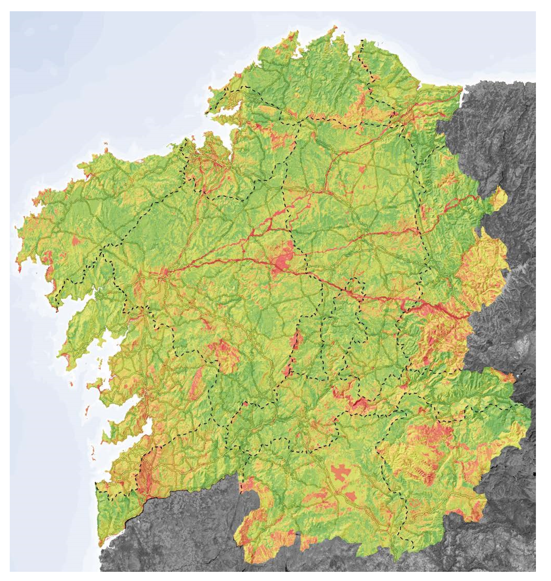
2.1.2. Catalog of Galician Landscapes

The Xunta Gallega, the highest governing body of the region, has carried out extensive work on landscape issues at both the regulatory and practical levels. The Landscape Catalogue, coordinated by the Instituto de Estudios Teritoriales, completes, together with a landscape law, the so-called Atlas of the Landscapes of Galicia. The catalog follows some previous works: the Coastal Management Plan and the Map of the Large Landscape Areas, which divides the territory into 12 zones and these, in turn, into 50 regions. This map is the base for the entire development of the Catalog.
The method from Galicia is perhaps the most systematic of the three studied. All actions are focused on developing a GIS-based model that uses standardized information. The landscape units result from the superimposition of three different layers of data: geomorphology, land use and climatic division. The first is extracted from the official digital terrain model (DTM) of the Spanish National Geographic Institute; the second combines data from the Spanish Land Use Information System (SIOSE) with certain areas of the Natura 2000 Network and the delimitation of historic centers prepared by the regional government. Finally, the third layer is based on a division according to thermotypes elaborated in 2007 [30]. With the exception of this last layer (included in the model as it was created) the other two are processed. The DTM is composed of pixels dated in 2009 and 2011 which, by GIS calculation, return both altimetric and clinometric information. The Land Use data is used to define spatial patterns using specialized metrics software. The superposition of all these layers results in 28,350 units classified according to 258 different landscape types.
The characterization and assessment that follows are equally systematic and consist, first, of gathering multiple data, from lithological information to specific land uses, to the location of various types of cultural assets, to the calculation of visual watersheds. Although these factors are of interest separately, the landscape is evaluated by adding them together: each mapped factor given a specific score. They define a range of natural values where certain pixels are given a score depending on whether they are part of a protected area or not; a range of cultural values, where pixels would get points according to their proximity to different heritage elements; and finally, a range of panoramic values, where visual basins from different areas are scored. Both the latter and the proximity to heritage assets are obtained thanks to computational calculation. The final total score configures the map of landscape values.
Finally, public participation, managed mainly by workshops of experts and landscape users in general, refines the results of both the division and the valuation. In particular, the development of a PPGIS (Public Participation GIS) to involve people directly in the catalog process stands out. This web tool consisted of a dissemination map of places of interest, landscape values and degraded areas. In addition, it allowed users to delimit their own areas, assigning them different values or expressing their opinions or preferences.

2.1.3. Landscape Catalogs in Catalonia: Method

In Catalonia, landscape cataloging and evaluation is carried out by the Observatori del Paisatge (Landscape Observatory), an advisory body for the Catalan administration and for raising awareness of landscape issues in society in general. The work of the observatory has been coordinated by Joan Nogué and Pere Sala i Martí, who have managed a multidisciplinary team to develop a method of knowledge and governance that will serve for future specific landscape guidelines. The catalog is derived from general legislation and is a prerequisite to local intervention. A temporal precision that also limits spatially its scope, limited to a territorial scale of application based on seven county divisions and delimited cartographically (at a scale of 1:50,000). The process of dividing the counties into landscape units implies at the same time a certain characterization. As specified in the report, the units here are not typological, nor are they limited to “merely structural elements” such as relief or land use, nor do they arise from “simple cartographic superimposition” [29] (p. 49). Rather, they are shaped by an in-depth analysis of many other factors such as the climate, the remnants of different human activities over time, sensory perception and socio-ecological dynamics.
The process consists of several phases. In the first, more systematic phase, a GIS model is elaborated to allow a first delimitation of units. The starting information is taken from various sources, especially from the Cartographic and Geological Institute of Catalonia, and consists of land use maps, DTMs or vegetation maps, among others. Information on settlement patterns, parcel structures or road networks, as well as visual basin and intervisibility studies derived from the DTM are also incorporated. They include also ongoing projects in both urban and rural areas. The first approach to a series of units provided by this GIS model is refined with an in situ study of character or sensory perception and a complex process of public participation. For this, different forms of survey and interview are conducted depending on the specific stage of the method. They incorporate specific workshops aimed at landscape experts, where different opinions are drawn by hand on maps to then rectify the decisions made on the original model.
134 landscape units result from this process. The evaluation phase consists of mapping a multitude of factors classified as “natural”, “aesthetic”, “historical”, “social use”, “symbolic” and “productive”. The sources of information are either documentary, oral or the result of consultation with experts. Many of the maps locate certain land uses, spatial patterns and prominent places. Some are particularly complex, for example those of olfactory perception that map places with a characteristic odor such as tilled land, mown grass or aromatic plants. In certain landscape units, an attempt has been made to capture a density of historical values in the territorial continuum once several elements of interest have been studied. Finally, and after being subjected to public evaluation through workshops, a SWOT (Strengths, Weaknesses, Opportunities, and Threats) analysis is elaborated. It determines positive and negative aspects of each landscape and, consequently, which places deserve special attention either because of their uniqueness or because they are subject to major transformations.

2.2. Method

Research consists of establishing a two comparative reading of the three case studies: a general one and one based on their different phases, paying attention also to the perceptual factors. In the first case, comparison is made through three coded diagrams: yellow for the territory division phase, blue for the characterization phase and brown for the valuation phase. The mixture of phases is understood as the mixture of their colors and fewer common phases are marked in purple. The phases are ordered from left to right and their height indicates the intensity of work required. This intensity is measured based on the attention each phase receives in the document and the overall workload involved. The scheme allows, graphically, a comparative interpretation of the importance of each phase or of the relationships between them. The second comparative reading consists of tabulating the main information according to the categories of “functional orientation”, “division of the territory”, “landscape characterization”, “valuation” and “treatment of perceptive factors”. This makes it possible to compare the particularities of each method.

3. Results

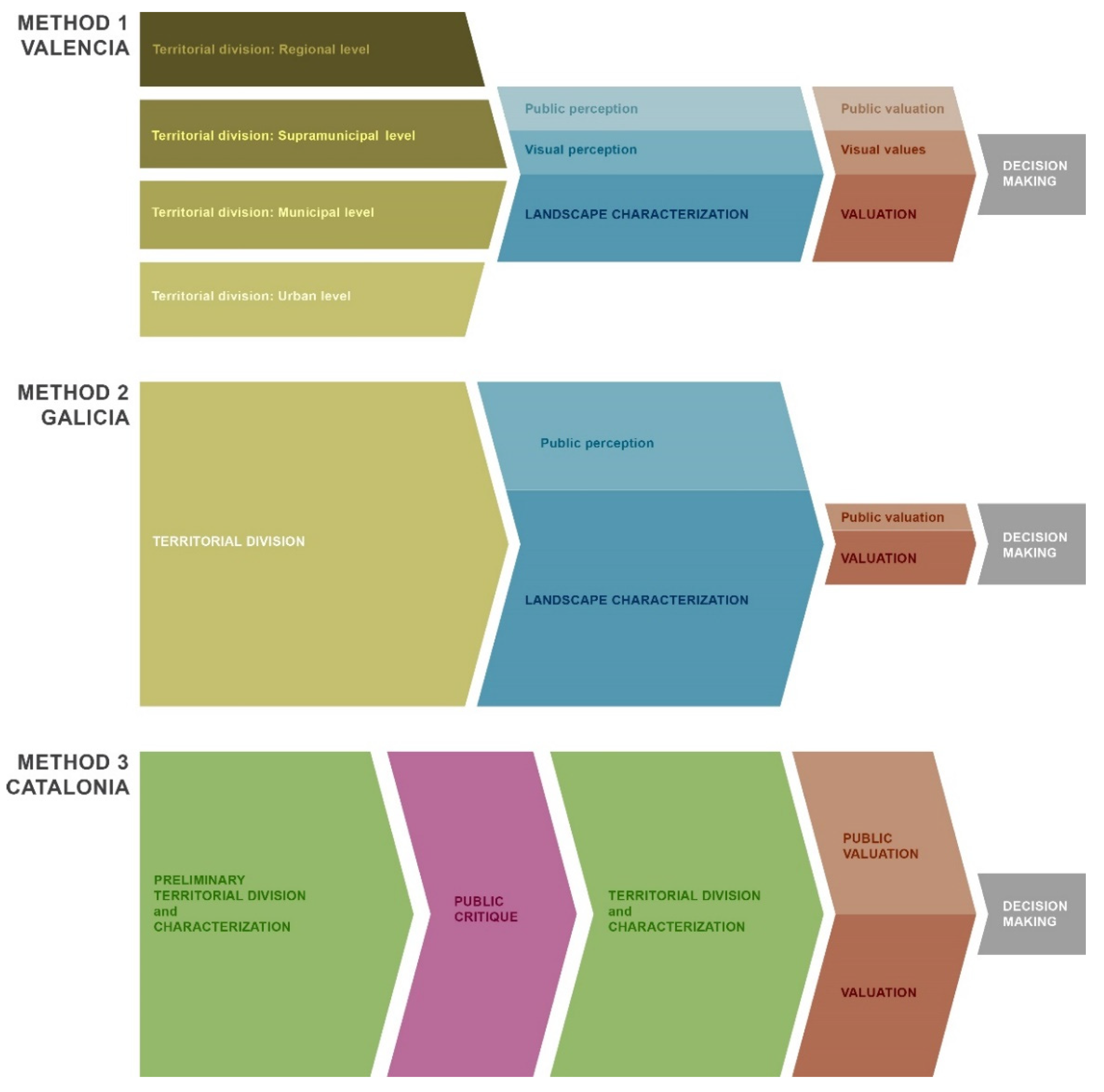
3.1. Methodology Comparisson

A graphic comparison of the three methodologies (Figure 1) shows that, in general terms, they all maintain a clear linearity. That is to say, none of the subsequent phases (characterization or evaluation) influences or modifies the previous ones. In Catalonia, given that the division into landscape units is strongly supported by the characterization, these cannot be two distinct phases. In that sense, Valencia and Galicia are more similar. The difference is that in Valencia the division phase can be executed at four different scales, while in Galicia the division is unique and applies throughout the territory equally. In Valencia, then, we are faced with a process that can be multiplied by four, since each landscape unit can then be characterized and evaluated independently of the rest.
As for the comparative relationship between phases, the three cases coincide in giving importance to the division. This, in fact, provides specific criteria for the following phases. In the Valencian case, characterization and assessment receive less attention, but are relevant to the whole. In contrast, in Galicia, much more importance is given to characterization than to subsequent evaluation. This is due to the fact that the evaluation arises from characterization data computation, which is much more elaborate in terms of information enrichment. In other words, in Galicia, more than in any other community, the assessment is understood as a by-product of the previous phase and can change as long as the latter is modified. Catalonia devotes the same work to each of the phases, combining the first two to favor a particular analysis for each unit in the assessment.
The main difference lies in the articulation of public opinion and perceptual values within the process. In Valencia and Galicia, it complements the characterization and assessment phases. Catalonia establishes public participation as a phase in itself. It does not complement the rest but is a critical filter between two phases of division/characterization. Here, citizens participation in the valuation of the landscape is also very broad. In Valencia, on the other hand, visual studies are treated as an independent resource and valued as such. This does not happen in the other two. Although they deal with visual perception, it is valued with less independently from other factors.

3.2. Phases Comparisson

Even if the methods are similar in their configuration, the individualized study of their phases (Table 1) shows major differences. Already at the starting point, i.e., in their functional orientation, two tendencies can be observed. In Galicia and Catalonia, the method serves a more traditional cataloguing, which accompanies a specific law to establish certain landscape principles derived from the ELC for future plans. In Valencia, the method is designed to accompany each of these plans. It has a clear operational purpose in the sense that a given administration, when commissioning a specific plan (regional, municipal or urban scale), is at the same time commissioning a landscape analysis. From this derives another issue: in Valencia, the results of the method are detached from their original authors and are left in the hands of the people who are going to elaborate the work in the future. In Galicia and Catalonia, on the other hand, the divisions, character and values are already fully determined.
The main differences in each phase are discussed in depth below.

3.2.1. Landscape Units

Here, we find the greatest methodological division, which is even a theoretical division if we take into account that Catalonia includes a reflection on the landscape units, their usefulness and their values. The first question is where each method starts from. In Valencia, the divisions are established according to scale. There is never a division at the level of the Autonomous Community, where certain landscapes of special interest must be respected. The division itself, which depends on various scales, is made mainly according to geomorphological issues at the supra-urban level and the configuration of settlements at the smaller scale level. Being based on geomorphology, the units follow above all the orography and rivers. This makes the criterion for classifying landscapes very similar to that for mapping the green infrastructure of the Valencian Community (taking rivers as powerful ecological corridors). This practical orientation thus makes it possible to link the regional scales with the general scale of the community at an ecological rather than a territorial level.
In Galicia and Catalonia, the starting point is a pre-existing division of the community into counties or landscapes. In Galicia, this is not fundamental for its subsequent development, since the division into units is extremely systematic. Their decisions focus mostly on the types of information that will generate the units. The process is immediate and the one that most involves geocomputing. Thanks to this, landscape dynamics that are difficult to perceive otherwise, such as the spatial patterns that constitute the land cover, can be noticed. In Catalonia, the starting point in county divisions does not completely condition the landscape units, but it is a previous step of control over the geographic continuum. To the extent that without such a plan, it would be difficult to replicate the method in other places. The process of division here combines a more systematic phase of cartographic superimposition and brief characterization with another of definitive definition of the units after a process of public participation.
In this way, a comparison can be made referring to the starting point as something that conditions the rest or not. In Valencia it is unnecessary. In Galicia, it serves as a control mechanism for the resulting units, which are very small, but it does not guide the final division. In Catalonia, it is both necessary and orients the process. The other comparable characteristic is the degree of systematization. Galicia, in this case, offers the most replicable method, but perhaps less adjusted to local differences. In Valencia it is based on very clear principles for each type of unit, which makes it easier to reproduce without losing a certain relationship with the place. Catalonia combines systematics with particularity in a more complex process involving different agents and a much longer period of time. The result is better suited to the characteristics of the landscapes of Catalonia, but its consumption of resources and time and its dependence on the local make it difficult to replicate.

3.2.2. Characterization and Evaluation

The characterization phase also shows notable differences, above all because of the difficulty of conceptually specifying its task. In Catalonia, as mentioned above, it is part of the division into landscape units and is the link with the valuation phase. We can differentiate between two ways of proceeding. In Valencia and Catalonia, the unit itself is characterized and a series of factors to be evaluated within that unit are established. In the Valencian case, these are called resources and constitute three classes: natural, cultural and visual. Each one has subclasses that the team in charge of the study has to locate within the unit. In Catalonia, they are called variables and are more complex as they include temporal factors, such as the historical sense of place and the dynamics of recent change, and perceptual factors, such as the sense of place. The other way of proceeding is in Galicia, where the entire autonomous community is characterized. The reference GIS model and the maps that appear in the document are centered on Galicia as a whole, regardless of the factor being treated. This model is open to the incorporation of independent factors of any category, which makes it more open and adaptable over time. Even so, its systematics, once again, takes it away from the local.
In all three methods, characterization influences valuation. They can, in fact, be compared on the basis of how systematic the passage from one phase to another is. In first place would be Galicia, with a purely mathematical process resulting in a heat map (Figure 2). Next would be Valencia, which scores several factors to sum and classify landscapes into five different categories: from Very High Value to Very Low Value. Finally, Catalonia carries out a consultative process involving specialized agents, citizens and on-site visits to the sites. For each unit, specific maps are made of its values, in order to know them better and incorporate them into a SWOT analysis. Therefore, there is no clear category of value for each landscape, but the result of such analysis. This implies that, in Catalonia, landscapes are not so much categorized after evaluation as they are all treated equally.

3.2.3. Visual Perception and Public Participation

The three methods coincide in giving more importance to sight in perceptual terms. They also agree that this factor has to be measured on a GIS model, with Galicia and Catalonia specifying that it has to be done on a DTM. The factors to be considered are also similar: the degree of visual exposure in a territory in general, view from preferred points, view from routes and degree of intervisibility. This is an important aspect for all three documents, but especially in Valencia, where it receives a particular annex to the main text. Galicia, for its part, explains the calculation in a systematic way, which helps its replicability. In Catalonia, although it devotes less space to it, emphasis is placed on the usefulness of this type of study, not only to know the degree of visibility, but also to know how visible the main landscape impacts are.
As with visual perception, the three documents emphasize citizen participation. Valencia, not having as broad a practical background to the method as the other two cases, limits itself to listing the possibilities and potential for participation and only gives the example of a citizen workshop. In the Galician and Catalan cases, the effort in this sense is greater. In Galicia, apart from the workshops, the elaboration of a PPGIS opens up the possibility of direct citizen participation, despite having the typical difficulties that come with the fact that not all citizens can operate a software of this type. Catalonia establishes a complex system of public participation with various options for each landscape unit (Table 2).

4. Discussion

The implementation of the ELC in different countries is a difficult matter to trace. It is complex to recognize the degree of penetration of the Council of Europe’s ideas in 40 different countries, with such different idiosyncrasies, and given the large number of actions that can derive from the Convention. Moreover, the landscape, like the laws that govern it and the societies that inhabit it, is a continually changing and evolving element, which makes it more difficult to monitor. Even so, Graham Fairclough et al. [22] have recently insisted on the great impact of the ELC on Landscape assessment actions. Especially in the European ones and in those specifically oriented to study the character of the landscape. The three cases we have seen here would are part of this collective response to the ideas of the ELC; although none of them focus solely on the “character” of the landscape and incorporate other facets such as ecological potential, socioeconomics or adaptability to specific political actions.
Graham Fairclough et al. also propose other factors that demonstrate how Catalonia, Galicia and Valencia are fully aligned with the spirit of their European counterparts. On the one hand, the assumption of the ELC definition of landscape, which allows the integration of different approaches to the problem of landscape assessment, and, on the other hand, the desire to unify, with a common objective, professionals from different fields, the population and the administration. It seems that the academic field has paid more attention to the work developed in Catalonia [7,31]. This may be due to the great work of dissemination of its activities carried out by the Observatori de Catalunia. In any case, the comparison shows that the Catalan case is not a paradigmatic Spanish example, but one derivative of the Convention among other possible ones. In turn, this highlights the need for more comparative analysis at the regional level within a country, rather than at the national level. An idea already defended by some authors [32].
Despite not focusing solely on assessing landscape character, all three methods appear to derive, to a lesser or greater extent, from British Landscape Character Assessment methodologies. These, developed in the UK, particularly in the 1980s and 1990s [33], are underpinned by a very similar process. In one of the reference documents, “Landscape Character Assessment: Guidance For England And Scotland”, produced in 2002 on behalf of The Countryside Agency and Scottish Natural Heritage, Carys Swanwick [34] defines an assessment method very similar to those mentioned above. Firstly, there is a so-called “Desk study”, where the sum of biotic, geomorphological and climatic factors is taken into account, together with other cultural factors such as land use or historical evolution. This results in a series of landscape types or a map of landscape areas. Subsequently, a field survey incorporates questions related to aesthetic and cultural perception. This is followed by a description of the components of each type or area and the establishment of evaluation criteria. In practically all the phases, stakeholder participation is possible.
The similarities of this method with the three Spanish methods are evident. Above all, they also establish a linear sequence that necessarily starts from a larger area to divide it into smaller landscapes, characterize them and evaluate them. The closest is the Catalan method, which also emphasizes the character of the landscape and is divided between desk work and field work, with the possibility of integrating stakeholders in all phases. In this almost direct adaptation of the British work-process to the ELC principles, the Catalan method is in line with other European cases, such as the “Landscape Act” ratified in Poland in 2004 to fulfill the requirements of the European Commission [35,36,37]. Furthermore, both follow the line marked by recent updates of the traditional British landscape character assessment method, which link it directly to the ELC [38]. In other words, the latter has become a theoretical background to the former and justifies its application (when in fact the method itself predates the Convention).
The Galician case follows a more impersonal drift, based on computer calculation. In fact, it does not so much establish a landscape character, but rather a landscape typology. In this sense, it is heir to systematic typological mapping methods from the beginning of the 21st century, such as the ENVIP-Nature study [39]. This program was oriented to the implementation of the Natura 2000 network and was based on a standard landscape characterization from data obtained by remote sensing and processed by GIS. This type of operation is usually carried out over large areas of land, for example the European continent [40]. Despite that, countries such as Belgium have long catalogued their landscapes in a similar way. The method developed there by Van Eetvelde and Antrop in 2005 [41] determined a grid cell similar to the Galician one, even if it limited the landscape types to 48 (less than a quarter of the Galician types). The authors of the Galician method themselves recognize that its aim was “to produce a map based on a simple methodology, easily replicable, based on transparent decisions and documented as thoroughly as possible” [28] (p. 14). Galicia thus moves away from the local character of the landscape. Despite this, this type of analysis allows a detailed understanding of landscape dynamics such as changes in spatial structure through comparison of Land Use and Land Cover changes [42]. In short, it is a method that values geography equally and enables its continuous observation over time, detecting problems such as the segregation of the territory or the impact on ecosystem services [43].
The Valencian case departs somewhat from a simple parallelism between established methods. On the one hand, it does not limit the scope of the assessment, something that was already implicit in the British method itself. Swanwick already defines the optimal result of his method as “a nested series or a hierarchy of landscape character types (…) so that assessment at each level adds more detail to the one above” [34] (p. 10). Thus, the Valencian method also relates the landscape character assessment with the ELC at the structural level. Contrary to the Catalan method, which always limits the scale of the characterization. Even so, the Valencian method, by directly relating it to the green infrastructure, also puts the maintenance of the socio-ecological viability of the landscape before the deep knowledge of its character.

5. Conclusions

Several conclusions can be recapitulated based on the proposed objectives. Firstly, the aim was to study the different methodological possibilities of knowledge and evaluation of the landscape following the ELC. In this sense, the methods all follow a mostly linear process. As the Convention establishes that the geographic totality must be observed, the derived method has to begin by dividing that totality into more manageable types. The convenience that the concept of landscape units offers for such an undertaking is also evident, although the way of approaching it may be very different. Once the territory has been divided, the landscape has to be evaluated through a process of characterization that provides specific values. Within this similarity between the linearity of the process, the possibilities can be very different and could even be combined between methods. A more practice-oriented approach can be based on several landscape units according to the scale of the plan to be developed (Valencia). A systematic approach can calculate the superposition of specific layers, both to divide and to evaluate the landscape (Galicia). Finally, a more citizen-oriented approach may combine a systematic phase with a critical phase in which the units are refined (Catalonia). Taken together, each approach is based on different predecessors, but offers a response dependent on the interests of the landscape study itself without departing from the ELC framework.
Second, it was intended here to compare the strengths and weaknesses of each method. Each offers positive and negative aspects in this regard. Valencia, with its instrumental attitude to landscape units and linking the larger ones to geomorphology, relates landscape plans to green infrastructure plans. This, which the other two do not address, brings the ELC principles closer to the UN Sustainable Development Goal (SDG) 11: to make sustainable cities and communities [44]. On the other hand, Galicia opens the possibility of an analysis based on computational systematics, fast and extrapolatable to almost any geography. Catalonia, in turn, provides the tools to correct such an approach and bring it closer to local particularities. This brings back a series of negative aspects, for example, that in Galicia the valuation is relegated to the assignment of a score to each pixel on the GIS model. In contrast, a more complex form of valuation would be that of Catalonia, which involves a wide variety of social agents and citizens. However, this results in a method that cannot be extrapolated.
Here, appears the greatest difficulty in dealing with the third and last objective: to determine which actions are most appropriate for landscape governance in relation to the demands of territorial sustainability and involvement of the population. The ELC treats the landscape as perceived geography, i.e., processed by a given culture through its experience and representations. This does not mean that it is exempt from observing that same geography in its ecological dynamics and with clear objectives of sustainable development [9,16]. Therefore, methods that want to respond to SGD 11 imply a deep scientific knowledge of the environment, such as that provided by reading spatial patterns and their evolution. This type of study has already provided remarkable results in Spain to test the feasibility of landscape protection [25]. Therefore, the processes elaborated in Galicia and Valencia, in one way or another, bring the concept of landscape closer to that of territorial sustainability. In Catalonia, more than in any other, they focus on involving the population in decision-making. The process they develop, which also includes field visits, generally centers on landscape perception and experience. That is, landscape as a cultural product rather than as a socio-ecological system.
The combination of the three methods in this sense could provide a contemporary approach to the ELC: taking as a starting point operational landscape units divided by scales; linking larger scales to green infrastructure and smaller scales to spatial patterns derived from land uses; establishing mechanisms of critique and correction through public participation that allow the divisions to be revised; and finally, combining quantitative and qualitative forms of evaluation that allow for more informed decision-making.

Funding

This research was funded by the Spanish Government R + D Plan, RED2018-102558-T.

Institutional Review Board Statement

Not applicable.

Informed Consent Statement

Not applicable.

Data Availability Statement

Not applicable.

Conflicts of Interest

The author declares no conflict of interest.

References

  1. International Union for Conservation of Nature (IUCN). Guidelines for Protected Area Management Categories; IUCN: Gland, Switzerland; Cambridge, UK, 1994. [Google Scholar]
  2. United Nations Educational, Scientific and Cultural Organization (UNESCO). Convention Concerning the Protection of the World Cultural and Natural Heritage. In Proceedings of the World Heritage Committee Sixteenth Session, Santa Fe, NM, USA, 7–14 December 1992; UNESCO: Santa Fe, NM, USA, 1992. [Google Scholar]
  3. Council of Europe. European Landscape Convention; Council of Europe Publishing Division: Strasbourg, France, 2000. [Google Scholar]
  4. Déjeant-Pons, M. The environmental, cultural, social and economic dimensions of the landscape. A look at current experiences on the threshold of the 20th anniversary of the adoption of the Convention. Econ. Cult. 2019, 3, 357–370. [Google Scholar] [CrossRef]
  5. Déjeant-Pons, M. The European Landscape Convention. Landsc. Res. 2006, 31, 363–384. [Google Scholar] [CrossRef]
  6. Scott, A. Beyond the conventional: Meeting the challenges of landscape governance within the European Landscape Convention? J. Environ. Manag. 2011, 92, 2754–2762. [Google Scholar] [CrossRef] [PubMed]
  7. De Montis, A. Impacts of the European Landscape Convention on national planning systems: A comparative investigation of six case studies. Landsc. Urban Plan. 2014, 124, 53–65. [Google Scholar] [CrossRef]
  8. García-Martín, M.; Bieling, C.; Hart, A.; Plieninger, T. Integrated landscape initiatives in Europe: Multi-sector collaboration in multi-functional landscapes. Land Use Policy 2016, 58, 43–53. [Google Scholar] [CrossRef] [Green Version]
  9. Janssen, J. Sustainable development and protected landscapes: The case of The Netherlands. Int. J. Sustain. Dev. World Ecol. 2009, 16, 37–47. [Google Scholar] [CrossRef] [Green Version]
  10. Terra, T.N.; dos Santos, R.F.; Costa, D.C. Land use changes in protected areas and their future: The legal effectiveness of landscape protection. Land Use Policy 2014, 38, 378–387. [Google Scholar] [CrossRef]
  11. De Montis, A. Measuring the performance of planning: The conformance of Italian landscape planning practices with the European Landscape Convention. Eur. Plan. Stud. 2016, 24, 1727–1745. [Google Scholar] [CrossRef]
  12. Jones, M.; Howard, P.; Olwig, K.R.; Primdahl, J.R.; Sarlöv Herlin, I. Multiple interfaces of the European landscape convention. Nor. J. Geogr. 2007, 61, 207–216. [Google Scholar] [CrossRef]
  13. Council of Europe. Chart of Signatures and Ratifications of Treaty 176. Available online: https://www.coe.int/en/web/conventions/full-list?module=signatures-by-treaty&treatynum=176 (accessed on 12 February 2022).
  14. Council of Europe. Reservations and Declarations for Treaty No.176—Council of Europe Landscape Convention (ETS No. 176). Available online: https://www.coe.int/en/web/conventions/full-list?module=declarations-by-treaty&numSte=176&codeNature=4&codePays=DEN (accessed on 12 February 2022).
  15. Roe, M. Policy Change and ELC Implementation: Establishment of a Baseline for Understanding the Impact on UK National Policy of the European Landscape Convention. Landsc. Res. 2013, 38, 768–798. [Google Scholar] [CrossRef]
  16. Janssen, J.; Knippenberg, L.W.J. From landscape preservation to landscape governance: European experiences with sustainable development of protected landscapes. In Studies on Environmental and Applied Geomorphology; Piacentini, T., Miccadei, E., Eds.; IntechOpen: London, UK, 2012; pp. 241–266. [Google Scholar] [CrossRef]
  17. Jones, M. The European Landscape Convention and the question of public participation. Landsc. Res. 2007, 32, 613–633. [Google Scholar] [CrossRef]
  18. de Patrimonio Histórico, C. Plan Nacional de Paisaje Cultural [National Plan for Cultural Landscape]; Gobierno de España: Madrid, Spain, 2012. [Google Scholar]
  19. Osservatorio nazionale per la qualità del paesaggio. Carta Nazionale del Paesaggio. Elementi per una Strategia per il Paesaggio Italiano; Gangemi Editore spa: Rome, Italy, 2018. [Google Scholar]
  20. Borger, G.J.; de Jong, E.A.; de Snoo, G.R.; Stortelder, A.H.F.; Heijdeman, B.J. Landschapsmanifest. The Netherlands, 2005. Available online: https://edepot.wur.nl/118345 (accessed on 12 February 2022).
  21. Government of the Netherlands, Ministerie van Infrastructuur en Milieu. Environment and Planning Act—Explanatory Memorandum; Ministerie van Infrastructuur en Milieu: The Hague, The Netherlands, 2017. Available online: https://www.government.nl/binaries/government/documenten/reports/2017/02/28/environment-and-planning-act-%E2%80%93-explanatory-memorandum/EnglishtranslationExplanatorMemorandumEnvironmentAct.pdf (accessed on 12 February 2022).
  22. Swiss Confederation, Federal Office for the Environment. Swiss Landscape Concept. Landscape and Nature in Federal Policy Areas; Federal Office for the Environment: Bern, Switzerland, 2020. [Google Scholar]
  23. Fairclough, G.; Herlin, I.S.; Swanwick, C. Landscape Character Approaches in Global, Disciplinary and Policy Context: An Introduction. In Routledge Handbook of Landscape Character Assessment. Current Approaches to Characterisation and Assessment; Fairclough, G., Herlin, I.S., Swanwick, C., Eds.; Routledge: London, UK; New York, NY, USA, 2018; pp. 3–20. [Google Scholar]
  24. Sandström, U.G.; Hedfors, P. Uses of the word ‘landskap’ in Swedish municipalities’ comprehensive plans: Does the European Landscape Convention require a modified understanding? Land Use Policy 2018, 70, 52–62. [Google Scholar] [CrossRef]
  25. Marine, N.; Arnaiz-Schmitz, C.; Herrero-Jáuregui, C.; de la O Cabrera, M.R.; Escudero, D.; Schmitz, M.F. Protected Landscapes in Spain: Reasons for Protection and Sustainability of Conservation Management. Sustainability 2020, 12, 6913. [Google Scholar] [CrossRef]
  26. De la O Cabrera, M.R.; Marine, N.; Escudero, D. Spatialities of cultural landscapes: Towards a unified vision of Spanish practices within the European Landscape Convention. Eur. Plan. Stud. 2020, 28, 1877–1898. [Google Scholar] [CrossRef]
  27. Muñoz Criado, A. Guía Metodológica de Estudio de Paisaje; Conselleria de Infraestructuras, Territorio y Medio Ambiente: Valencia, Spain, 2012. [Google Scholar]
  28. Instituto do Estudios do Territorio. Catálogo das Paisaxes de Galicia; Xunta de Galicia: Santiago de Compostela, Spain, 2016. [Google Scholar]
  29. Nogué, J.; Sala, P.; Grau, J. Los Catálogos de Paisaje de Cataluña: Metodología; Observatorio del Paisaje de Cataluña: Olot, Spain, 2018. [Google Scholar]
  30. Rivas-Martínez, S.; Rivas-Saenz, S.; Penas, A. Worldwide Bioclimatic Classification System; Backhuys Pub.: Kerkwerve, The Netherlands, 2002. [Google Scholar]
  31. Nogué, J.; Sala, P. Landscape, Local Knowledge and Democracy: The Work of the Landscape Observatory of Catalonia. In Routledge Handbook of Landscape Character Assessment. Current Approaches to Characterisation and Assessment; Fairclough, G., Herlin, I.S., Swanwick, C., Eds.; Routledge: London, UK; New York, NY, USA, 2018; pp. 265–279. [Google Scholar]
  32. Dempsey, K.E.; Wilbrand, S.M. The role of the region in the European Landscape Convention. Reg. Stud. 2017, 51, 909–919. [Google Scholar] [CrossRef]
  33. Swanwick, C.; Fairclough, G. Landscape Character: Experience from Britain. In Routledge Handbook of Landscape Character Assessment. Current Approaches to Characterisation and Assessment; Fairclough, G., Herlin, I.S., Swanwick, C., Eds.; Routledge: London, UK; New York, NY, USA, 2018; pp. 21–36. [Google Scholar]
  34. Swanwick, C. Landscape Character Assessment. Guidance for England and Scotland. The Countryside Agency: Gloucestershire; Scottish Natural Heritage: Edinburgh, UK, 2002. [Google Scholar]
  35. Solecka, I.; Raszka, B.; Krajewski, P. Landscape analysis for sustainable land use policy: A case study in the municipality of Popielów, Poland. Land Use Policy 2018, 75, 116–126. [Google Scholar] [CrossRef]
  36. Krajewski, P.; Solecka, I. Management System of Urban Landscape in Poland on the Example of Wroclaw in the Context of European Landscape Convention Implementation. In IOP Conference Series: Materials Science and Engineering 471 (11); IOP Publishing: Bristol, UK, 2019; p. 112035. [Google Scholar]
  37. European Rural Architecture. Legislation in Poland. In Rural Architecture in Europe between Tradition and Innovation; Moretti, G., Ed.; Alinea Editrice: Firenze, Italy, 2005; Available online: http://www.pg.gda.pl/architektura/eurarc/pdf/polska/PLnorms.pdf (accessed on 12 February 2022).
  38. Tudor, C. An Approach to Landscape Character Assessment; Natural England: York, UK, 2014. [Google Scholar]
  39. Banko, G. Assessing and monitoring nature protection value of European landscapes using remote sensing and GIS tools. In Proceedings of the Space and Time-GIS and Remote Sensing Conference, Sopron, Hungary, 6–8 September 2001. [Google Scholar]
  40. Mücher, S.; Wascher, D. European landscape characterisation. In Europe’s Living Landscapes: Essays Exploring Our Identity in the Countryside; Pedroli, B., van Doorn, A., de Blust, G., Eds.; KNNV Publishing: Zeit, Germany, 2007; pp. 36–47. [Google Scholar]
  41. Van Eetvelde, V.; Antrop, M. Landscape character assessment in Belgium: Balancing natural and cultural properties. In Proceedings of the Mobiliteit, Maatschappij en Milieu in Kaart Gebracht, De Belgische Geografendagen, Bevas, deel II, Gent, Belgium, 9 November 2005; Société belge d’études géographiques: Brussels, Belgium, 2005; pp. 347–353. [Google Scholar]
  42. Wascher, D.M. European Landscape Character Areas: Typologies, Cartography and Indicators for the Assessment of Sustainable Landscapes; No. 1254; Landscape Europe: Wageningen, The Netherlands, 2005. [Google Scholar]
  43. Smiraglia, D.; Ceccarelli, T.; Bajocco, S.; Perini, L.; Salvati, L. Unraveling landscape complexity: Land use/land cover changes and landscape pattern dynamics (1954–2008) in contrasting peri-urban and agro-forest regions of northern Italy. Environ. Manag. 2015, 56, 916–932. [Google Scholar] [CrossRef] [PubMed]
  44. United Nations. 11. Sustainable Cities and Communities; UN: New York, NY, USA, 2018. [Google Scholar]
Figure 1. Diagram of landscape analysis methods.
Earth 03 00031 g001
Figure 2. Landscape evaluation map of Galicia (Red: High values; Green: Low values).
Earth 03 00031 g002
Table 1. Phase Comparison of method analyzed.
MethodFunctional OrientationDivision of the TerritoryLandscape CharacterizationValuationPerception Analysis
VALENCIA
  • Method as part of specific planning operations aimed at various scales.
  • No pre-existing division.
  • It uses landscape units at four different and interrelated scales.
  • Depending on the scale, the units are divided differently, usually according to geographic and urban configuration criteria.
  • Mapping of various resources deployed in the territory, including perceptual resources.
  • Based the tabulated scoring of both the landscape units and their resources.
  • Study of visual basins and the degree of visibility of spaces.
  • Sum of individual scores determines final value.
  • Organization of workshops for citizens to provide feedback and easily accessible local knowledge.
GALICIA
  • Method refers to the division and characterization of landscapes prior to any specific action.
  • Derived from pre-existing landscape division.
  • Only local scale landscape units.
  • Units obtained in a systematic manner by superimposing several layers of information.
  • Creation of a digital model on which multiple layers of information are superimposed: biotic, political, sociological, perceptual, and other issues.
  • Based on the GIS calculation of values assigned to the pixels that compose the model.
  • Study of visual basins from different media, as well as the degree of visibility of the spaces.
  • Organization of citizens workshops for their opinion and expert knowledge.
  • Creation of an on-line PPGIS that can include complex geometries.
CATALONIA
  • The method implements existing laws and addresses pre-action division and characterization.
  • Derived from pre-existing landscape division.
  • Landscape units without specific scale. Obtained by delimiting spaces with similar physical and intangible qualities. It involves landscape characterization.
  • Two types of units: preliminary and definitive.
  • Simultaneous with the phase of division into landscape units.
  • Based on the non-systematic mapping of multiple factors that depend on the specific unit.
  • Based on expert and citizens evaluation.
  • Organization of a multitude of workshops adapted to the different phases of the project and to the landscape units.
  • Surveys by phone and on-line.
  • Critical groups and individual interviews with local management agents.
Table 2. List of instruments, phases and type of citizen participation in Catalonia.
InstrumentParticipantsPhaseApplication
Telephone surveyGeneral populationAllSpecific units
Opinion surveyGeneral populationAllSpecific units
Web consultationGeneral populationAllAll units
Interview to expertsExperts and professionalsAllAll units
Focus groupsExperts and professionalsValuationSpecific units
Experts’ workshopsExperts and professionalsValuationSpecific units
Citizen’s workshopsGeneral populationValuationSpecific units
Open workshopsGeneral populationAllSpecific units
Publisher’s Note: MDPI stays neutral with regard to jurisdictional claims in published maps and institutional affiliations.

