Review

Hydro-Meteorological Incident and Disaster Response in Sri Lanka. Case Study: 2016 May Rain Events

by
Hiran I. Tillekaratne
1,*,
Induka Werellagama
2,
Chandrasekara M. Madduma-Bandara
3,
Thalakumbure W. M. T. W. Bandara
3 and
Amila Abeynayaka
4
1
Disaster Management Center (DMC), Vidya Mawatha, Colombo 00700, Sri Lanka
2
School of Engineering, Wellington Institute of Technology, Wellington 6011, New Zealand
3
Department of Geography, Faculty of Arts, University of Peradeniya, Peradeniya 20400, Sri Lanka
4
Graduate School of Environmental and Information Studies, Tokyo City University, Tsuzuki Ward, Yokohama 224-0015, Japan
*
Author to whom correspondence should be addressed.
Earth 2022, 3(1), 1-17; https://doi.org/10.3390/earth3010001
Submission received: 22 October 2021 / Revised: 12 December 2021 / Accepted: 14 December 2021 / Published: 24 December 2021

Abstract

:
This paper investigates hydro-meteorological hazards faced by Sri Lanka, a lower-middle-income island country in Asia. It provides a case study of a major hydro-meteorological disaster incident that resulted in one of the largest landslides in the history of the country, the Post-Disaster Needs Assessment (PDNA) process, and the national disaster response. Rainfall and flood inundation data are provided for the whole country. The fact that data are held by several government agencies (namely Department of Meteorology, Department of Irrigation, and NBRO), somewhat coordinated by the Disaster Management Center (DMC) is shown. The need for more streamlined coordination of hydro-met data with online access of data for researchers is emphasized. The flood disaster situation and disaster declaration of the Western Province (which contributes nearly 40% of the GDP) is looked at, and evidence is presented to recommend a smaller governance unit for future disaster declarations, in order to bring aid to the places where it is needed and leaving other areas of the province to carry on with the normal economic activity. An example of the use of climate change scenarios in rainfall prediction is provided from a developed island nation (New Zealand). The need for Sri Lanka to increase its spending for hydro-met services (both infrastructure and skills) is highlighted (the global norm being 0.02 of GDP), as the return on such investment is tenfold.

1. Introduction

Hydro-meteorology combines meteorology and hydrology to analyze the transfer of water and energy between the earth’s land surface and the lower atmosphere [1]. The management of incidents involved with high intensity precipitation and flood disasters can be supported with hydro-meteorological approaches [2]. However, in some geographic regions, data and information gaps such as unavailability, inaccessibility, or questionable integrity and quality exist due to various reasons [3]. It is obvious that these gaps of data and information can pose serious consequences when managing hydrological disasters.
The potential flooding damage of a precipitation event depends on number factors including the total amount of rain, its intensity, etc. [4]. Few studies have discussed the usefulness of the rainfall threshold, which is defined as the minimum or maximum level of a quantity needed for a process to take place or a state to change [5], as a first step to initiating flood warnings where hydrological simulations have not yet been performed or where hydrological simulations are unavailable [2,5]. For both simulation modeling and threshold-based warnings, the availability of quality data is important.
On the other hand, in recent years, as a result of climate change, the increased frequency and severity of rain-induced disasters can be seen [6]. Moreover, the significant uncertainties associated with the climate change projections and the associated disasters create challenges for decision-makers and practitioners on disaster management planning [7]. This is even more critical for developing countries where channeling funds for hydro-meteorological approaches and establishing accurate data information systems is a challenge.
In the 2012 Special Report [8] of Working Groups I and II of the Intergovernmental Panel on Climate Change (IPCC: Managing the Risks of Extreme Events and Disasters to Advance Climate Change Adaptation), a negative trend of moderate rain events and a positive trend in heavy and light rain events was reported for the Indian ocean monsoon region.
This paper looks at the types of hydro-meteorological hazards faced by an island country in Asia (Sri Lanka). It provides a case study of a rain-induced (hydro-meteorological) disaster that resulted in one of the largest landslides (and loss of life) in the recorded history of the country, and the disaster response process available for a middle-income country. Such a study can be useful from the viewpoint of “social hydrology” as well, which is a concept that has been in vogue since the early 2000s, as a means to better integrate hydrological and societal processes and connections [9]. At the end of the paper, a discussion is presented on how to improve existing hydrological data availability to local and international researchers who can model, to predict future hazardous hydro-met events. A developed island nation (New Zealand) is presented as an example of advanced modeling capability including historical data and how different climate change (model) scenarios can affect predicted rainfall amount, return periods, and rainfall intensity.
In the month of May 2016, parts of Sri Lanka were hit by the heaviest recorded rainfall in more than 18 years, which caused severe floods and landslides, one of which was the worst recorded in the country [10]. The Post-Disaster Needs Assessment (PDNA) for this incident is presented in Section 3.3. The PDNA is an internationally accepted methodology for determining the physical damages, economic losses, and costs of meeting recovery needs after a natural disaster through a government-led process [11].
The river basins affected are looked at considering inundation data, availability of rainfall data, quality of available data, and whether improvement opportunities are available (such as making data available to all stakeholders and researchers, recognizing the ARI of the rainfall, considering climate change scenarios affecting rainfall prediction models, meeting funding requirements, and accessing the benefits of investment on climate actions/modeling).

2. Materials and Methods

Study Area

Sri Lanka, an equatorial island country in Asia, is located between latitudes 5°55′ and 9°51′ N and longitudes 79°41′ and 81°53′ E and has a maximum length of 268 miles (432 km) and a maximum width of 139 miles (224 km) [12]. Sri Lanka has a population of 21.4 million [13] and a population density of about 350 per/km2 [14]. Colombo (situated in the Western province) is the commercial capital and the capital city Sri Jayawardenepura is in the same metropolitan area.
Sri Lanka is susceptible to hydro-meteorological hazards arising from atmospheric, hydrological, or oceanographic phenomena, as well as several other natural disasters. As depicted in Figure 1, the range of natural hazards includes drought, floods, landslides, tsunami, cyclones, high winds, lightning strikes, forest fires, urban fires, storm surges, coastal erosion, sea-level rise, etc. Human-induced disasters such as deforestation, soil erosion, indiscriminate (coral, sand, clay, and gem) mining, industrial and development-induced road accidents, epidemics, and biological and garbage-induced disasters can also affect the country. Out of 191 countries, Sri Lanka ranks 109th in the Risk Index and is classified as a middle-level risk category country (Risk Index, compiled using 28 indicators and research data on vulnerability and natural hazards) [15].
Natural disasters have caused loss of life and inflicted heavy damage and destruction to property. The frequency of these natural hazards is linked with rapid population growth and urbanization in low-lying areas [17] and the global climate change [18,19]. These phenomena (both natural and man-induced) are increasing the risks on ecosystems, communities and their livelihoods, infrastructure, and cultural resources.
The rainfall data regarding the 2016 May rain incidents in Sri Lanka were obtained from the Department of Meteorology [20], (Figure 2), [21] and the Hydrological Report [22] on the Kelani River Flood of May 2016.
Rainfall data were employed to identify the inundated areas and to map the behavior of floods in Figure 2 (which also shows catchment data). The flood data (inundated areas) were mapped using the ARC-GIS tool with the flood images (from Indian Radar Imaging Satellite 1 RISAT-1, dated 20 May 2016, provided to the Disaster Management Centre, Sri Lanka). River basins were considered as natural water flow systems and the flood layer in 2016 was overlaid to calculate the exact inundated area. By 20 May 2016, the flood water had receded considerably in the Kelani River compared to that reported on 18 May 2016.
The Post-Disaster Needs Assessment (PDNA) was carried out by the Ministry for Disaster Management and the Ministry of National Policies and Economic Affairs with the support of international and national experts from the United Nations, World Bank, European Union, and the line ministries [10].

3. Results

3.1. Hydro-Meteorological Hazards

A hazard is defined as any source that can cause harm or damage to humans, property, or the environment. A hydro-meteorological hazard is defined as a “process or phenomenon of atmospheric, hydrological or oceanographic nature that may cause loss of life, injury or other health impacts, property damage, loss of livelihoods and services, social and economic disruption, or environmental damage” [1]. The types of hydro-meteorological hazards affecting Sri Lanka are shown in Figure 1 [16,23,24]. Intense and cumulative rainfall during monsoon and inter-monsoon seasons is the most pressing rain hazard. Precipitation received by the inland central hilly terrain finds its gravitational way through the river basins towards the sea along a radial flow system. Heavy antecedent precipitation slows down the infiltration due to low absorption, creating flood disasters in the downstream communities.
The rain events of 2016 May (during the south-west monsoon rain period) were selected as a case study for this paper because they created massive human and material losses, making many scientists wonder whether we can improve existing early-warning systems, thereby avoiding risk. Risk is defined as the probability of a hazard event causing harmful consequences (loss of life, injuries, damage) [25]. The impact of the 2016 May disasters led many researchers to publish about this event both locally and internationally during the past five years, which has made a wealth of data available for review, supplemented by data available from DMC.
When presenting methodologies for using hydro-meteorological data in multi-hazard disaster risk assessment, natural disasters with hydro-meteorological antecedents were discussed for Sri Lanka [26]. Drought- and flood-prone areas were mapped using rainfall data that was gridded at a resolution of 10 km. Multi-hazard analysis highlighted regions of high risk in Sri Lanka, such as the Kegalle and Ratnapura Districts in the south west; the Ampara, Batticaloa, Trincomalee, Mullaitivu, and Killinochchi districts in the north-east; and the districts of Nuwara Eliya, Badulla, Ampara, and Matale, which contain some of the sharpest steepest hill slopes of the central mountain massifs. The highest landslide risk was identified in Kegalle district, six years ahead of the disaster events described in this paper. The existence of a distinct seasonality to risks posed by drought, floods, landslides, and cyclones was also noted [26]. There is a visible effect of the El Niño Southern Oscillation (ENSO) event on inter-seasonal variability of rainfall in wet and intermediate zones of Sri Lanka [27].
How climate change related hydro-climatological events affect the food security in Sri Lanka is discussed in [28]. Spatial and temporal changes in the surface water area of Sri Lanka over a 30-year period were studied using Landsat 5 and Landsat 8 images to generate per-pixel seasonal and annual water occurrence frequency maps (for the period of 1988–2019). The authors concluded that climate change and anthropogenic activities affect possible spatiotemporal changes in surface water availability in Sri Lanka [29].

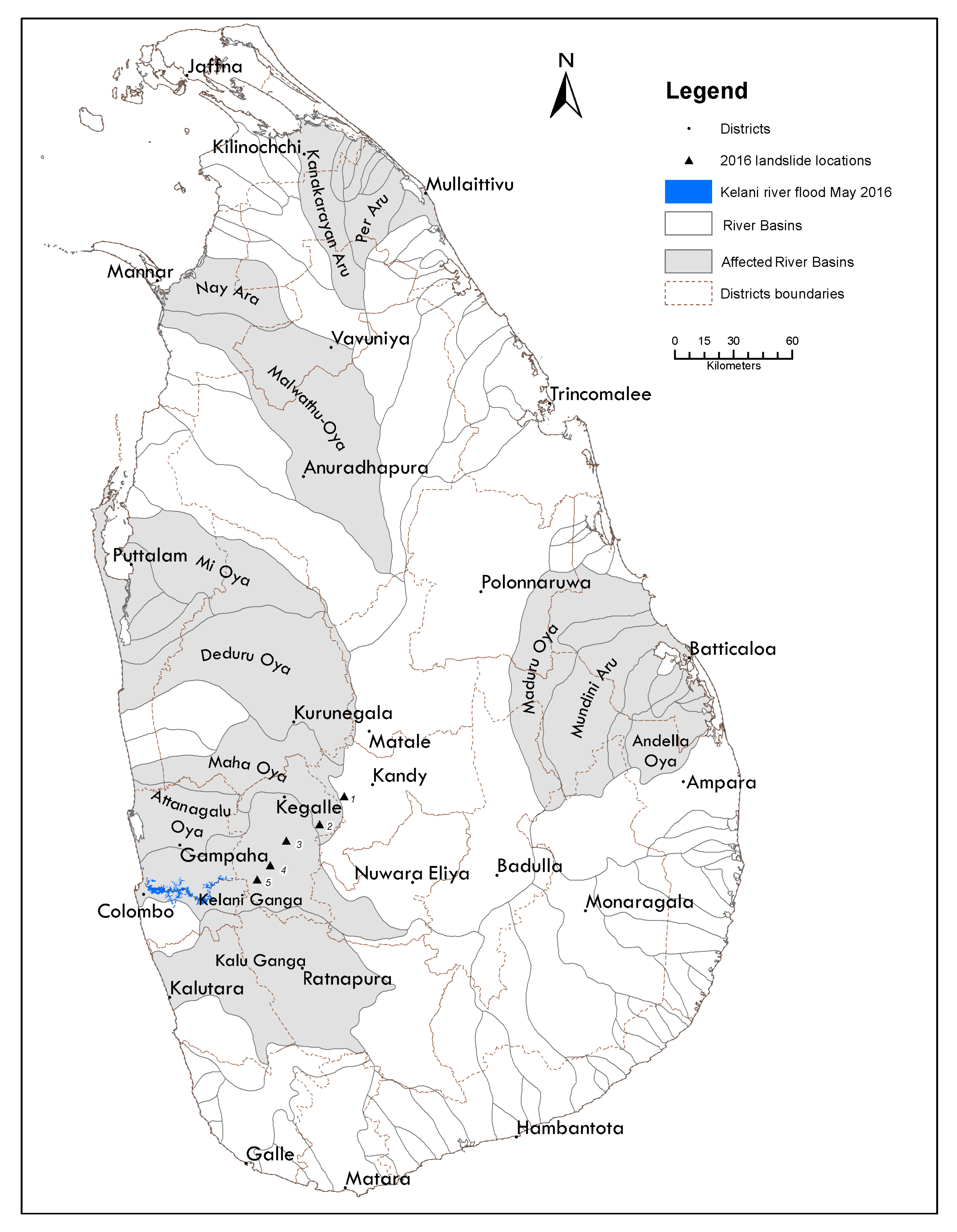
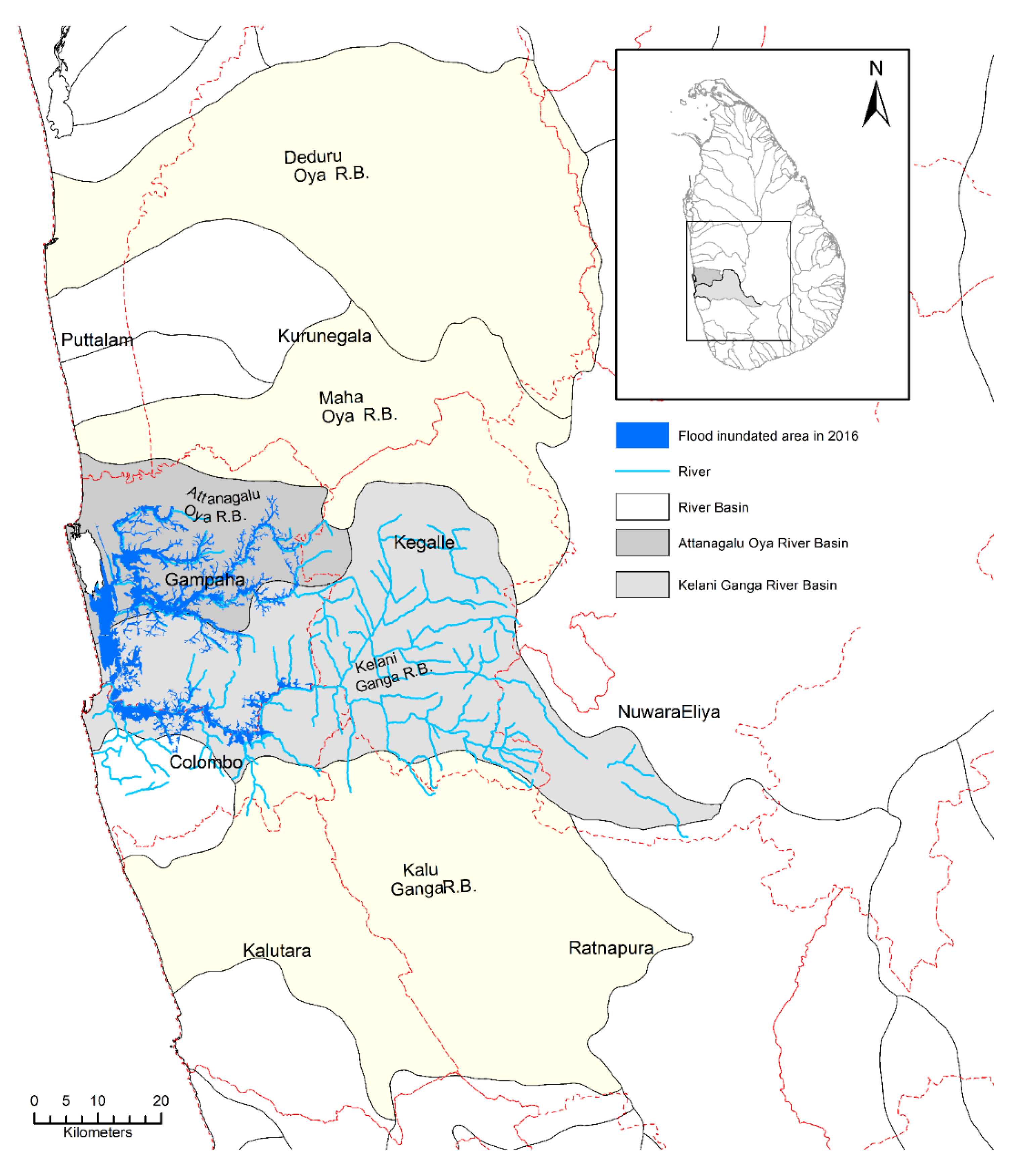
3.2. How Did the Rain Incident of 2016 May Affect the 103 River Basins in Sri Lanka?

The rainfall that occurred over 8 days (Tropical Cyclone Reanu) in Sri Lanka from 13 to 20 May 2016 are given in Table 1 of paper [22] titled “Hydrological Report on the Kelani River Flood in May 2016”. Daily rainfall data of stations in Kitulgala (Irrigation Dept; ID), Castlereagh (Ceylon Electricity Board; CEB), Norton (CEB), Maussakele (CEB), Canyon (CEB), Laxapana (CEB), Norwood, Deraniyagala, Holombuwa, Glencourse, Hanwella, Colombo (ID) and Colombo (DoM) are available.
Hettiarachchi et al. noted “The flood (in May 2016) was one of the most severe hydrological hazards faced by the people of the Kelani River basin [23]. The catchment rainfall magnitude (8-day total) was 558 mm. The spatial and temporal distribution showed distributed patterns along the whole catchment. The recorded highest rainfall (2016 May) was 898.8 mm at Deraniyagala. Flood frequency analysis revealed that the return period (ARI) of the 2016 flood was around 15-year (Annual Exceedance Probability, AEP of 7%). However, the damages of the 2016 flood were more due to irregular developments within the flood plain and longer durations of inundation. The Kelani Minor Flood Protection Schemes were severely affected in emphasizing the urgent requirement of modernizing them to cope with the present (larger flood) conditions”.
Rainfall intensities during this incident are also shown in color in Figure 2 above. Land area and inundation figures during these rain incidents are given in Table 1 below.
There are 103 river basins in Sri Lanka. Out of these, seven major rivers given in Table 1 were affected by the May 2016 heavy rain. These seven major rivers (Attanagalu Oya, Kelani River, Kalu Ganga, Bolgoda Lake, Bentota Ganga, Gin Ganga, and Nilwala Ganga) had 13 river sub-basins running through the five administrative districts of Gampaha, Colombo, and Kalutara (in Western Province), and Galle and Matara (in the Southern Province) being affected.
The Kelani River running through Colombo (commercial capital city) and the Kalu River at Kalutara have major flood levees on both the right and left banks to protect the city of Colombo and its suburbs. These two interprovincial rivers (i.e., rivers that run through more than one province) are linked by Bolgoda Lake, which has an estuary with two large lakes and two sea outfalls in Panadura and Kalutara.
The Kelani River originates from the central hills near the Adam’s peak and traverses 145 km through the south-western slopes of Sri Lanka to reach the sea at Colombo. The whole Kelani catchment is situated in the wet zone of the country. The average annual rainfall of the catchment varies from 5700 mm in the upper catchment to 2300 mm in the lower basin. The Kelani River basin is the seventh-largest watershed by area (approximately 2300 km2) and third-largest considering discharge (4225 MCM; average annual discharge) in Sri Lanka. It experienced large-scale flooding and caused subsequent damage to property and livelihoods. The highest 8-day total rainfall in the Kelani basin was 899 mm in Deraniyagala, recorded in 2016 May [22].
The Attangalu Oya irrigation system in the Gampaha District is located between the Kelani River and Maha Oya river basins. The upper reaches between the main Attangalu Oya and the Kelani River drain into the Kelani River and these areas are protected by minor flood protection levees and control gates. Kelaniya has a major flood protection levee, almost 5 km long, along the right bank of the Kelani River [22].
The 2016 May rain incident caused widespread flooding and landslides in 19 out of 25 administrative districts (see Figure 3) in Sri Lanka, damaging homes and submerging villages in several locations. As official reports indicated, the floods and landslides affected approximately 493,319 people (124,398 families) causing 93 deaths (36 women, 43 men, 10 children, 4 bodies could not be identified), 33 injuries and 117 missing people. The majority of the deaths and missing people occurred (155, i.e., 74%) due to landslides [30].
The worst flooding occurred in the districts of Colombo and Gampaha (shown in Figure 4), which were most affected because of the rising level of the Kelani River. Floods in Colombo District affected 228,871 members of 54,248 families. The overall statistics of affected people per district are given in Table 2 and Table 3 below.
As shown in Table 2, in 2016 May, the flood inundated area in the Western Province was 61.39 km2 in the Kelani River basin and 53.81 km2 in the Attanagalu-Oya basin, which is only 3.21% of the total land area of the province.
The estimated inundated area was approximately 200 km2 for Kelani River Basin, but other river basins were also affected, including the Deduru Oya (353 km2), Attanagalu Oya (165 km2), and Maha Oya (and Karambalan Oya), where the inundation area was about 150 km2. In total, the region of interest was approximately 1231 km2 covering 13 river basins. Most of the standing water was observed in abandoned croplands, cultivations, and household areas, and several main roads were disconnected, restricting the movement of people and transport [10].

3.3. The Post-Disaster Needs Assessment (PDNA)

The Post-Disaster Needs Assessment (PDNA) is an internationally accepted methodology for determining the physical damages, economic losses, and costs of meeting recovery needs after a natural disaster through government-led processes [11]. At the most basic level, the purpose of a post-disaster needs assessment is to assess effects and impacts to determine priority recovery needs. The PDNA exercise is government-led with technical and financial support from international partners [31]. The PDNA process has a significant focus on field-collected damage and loss data, and on working with in-country partners to develop reliable sectorwide damage and loss assessments. This capacity has been built on gradually evolving approaches since 2008 at the global level through the Prompt Assessment of Global Earthquakes Response (PAGER), the Global Disaster Alert and Coordination System (GDACS), and the Center for Disaster Management and Risk Reduction Technology (CEDIM) [32].
Since 2008, the World Bank and the Global Facility for Disaster Reduction and Recovery (GFDRR) have worked with the UN, EU, and other international donors to help governments prepare nearly 70 PDNAs in over 40 countries in all regions. Looking at the literature on the PDNA in the last decade, it can be noted that major guideline documents were published by the World Bank in 2010 [33], which outlined how the methodology was to be conducted: Post-Disaster Needs Assessments Guidelines Volume A in 2013 [34], World Health Organization PDNA Guideline in 2014, and the IBRD Global Facility for Disaster Reduction and Recovery (GFDRR) guideline in 2018 [32]. The funding for the disaster relief efforts is provided from these major donors; therefore, many countries have adopted these guidelines.
The IBRD 2010 Knowledge Notes [33] provides an overview of the post-disaster assessment process, extracting lessons learned in the East Asia Pacific Region (EAP) and presenting best practices from 2000s PDNA assessments. It explains the Post-Disaster Needs Assessment (PDNA) methodology, and outlines: (i) the assessment triggers, (ii) key steps in assessment planning, and (iii) dos and don’ts in assessment execution. The Post-Disaster Needs Assessment Guidelines of the World Health Organization (WHO) [35] provides guidance to national and international stakeholders involved in the health sector part of the Post-Disaster Needs Assessments (PDNA) and recovery planning.
In providing effective post-disaster relief, timeframes are important as affected people need help on day one. While PDNA guidelines [11] indicate that the exercise should take 6–12 weeks, the majority of cases reviewed were done in 3–4 weeks. Some of the tradeoffs of a shorter time frame were fewer field visits, reliance on secondary data, and less accurate or less comprehensive information on social parameters and household impacts. They noted that “rapid assessment techniques” should be considered when specific information is desired more quickly. GFDRR (2018) elaborates on rapid assessment techniques such as GRADE (Global Rapid Post-Disaster Damage Estimation) [32]. The GRADE approach is a remote, desk-based rapid damage assessment method deployed on request soon after a disaster, such as an earthquake or a tropical cyclone. It adopts evolving and innovative natural hazard risk modeling technology in order to rapidly fulfill post-event damage assessment requirements. It is an assessment of damages to housing and critical infrastructure sectors, derived by combining hazard parameters, exposure databases, extent of structural vulnerability, and relevant costs of repair and replacement. These components are overlaid on a geographic information system (GIS) platform, expert knowledge is applied, and results are produced within two weeks of major disasters.
However, rapid assessments cannot be equated with or replaced by the comprehensive and collaborative features that characterize PDNAs [11].
Table 3 shows the PDNA carried out for this disaster incident by the sources [10,13]. There are different categories of disaster effects in particular districts and vulnerability maps were prepared accordingly.

3.4. Landslides That Resulted from the 2016 May Rain Incidents

The high rainfall triggered several landslides in the hilly Kegalle and Kandy Districts, while minor slides also occurred in Ratnapura District.
The worst-ever recorded large-scale sediment (earth) slip in the country occurred on 17 May 2016, in Aranayake, in Kegalle District, due to the heavy rainfall from 15 May onwards. The Aranayake (Siripura-Samasarakanda) landslide on 17 May 2016 around 17:30 (with previous day 435mm rainfall) devastated three villages. The land destroyed by this incident was 0.5 km2 (Table 4) and consisted of 29% homesteads, 32% tea plantations, and 21% natural forest. According to landslide hazard zonation maps prepared by the National Building Research Organization (NBRO), this is an area where landslides are most likely to occur. 31 bodies were recovered, but 96 persons were missing. Additionally, 110 houses were destroyed and 2629 persons of 916 families were given shelter in 16 safety centers as of 2 June 2016.

3.5. Disaster Response (Search and Rescue) and Relief Following 2016 May Rain Incident

The mechanism available for disaster response in Sri Lanka is detailed in the book chapter “Command and Control Mechanism for Effective Disaster Incident Response Operations in Sri Lanka” [36]. In Table 4 above, data are given for the Divisional Secretary’s (DS) divisions, which are the smallest government disaster response agency within a District.
From the onset of the flood and landslide disasters in mid-May 2016, the Disaster Management Center (DMC) initiated search and rescue operations with the assistance of the Sri Lankan military forces and police to rescue people stranded on rooftops and isolated locations. The District Secretaries established 373 safe centers within the affected DS divisions, which housed over 115,000 people evacuated from the inundated areas and unsafe locations in the landslide-prone districts [37].
On 30 May 2016, the President of Sri Lanka declared a “state of disaster” for seven provinces, excepting just the northern and eastern provinces of the country [38]. About 71.82% of the land area of the country was covered under the disaster declaration.
As shown in the PDNA, when considering the Western Province, only 3.21% of the land was affected (61.39 km2 in the Kelani Basin and 53.81 km2 in the Attanagalu-Oya basin was inundated) due to the 2016 flood. The total affected population was 14.08% (9.85% in Colombo, 3.21% in Gampaha, and 1.02% in Kalutara District). Therefore, the practice of declaration of the “state of disaster” throughout the existing administrative provinces should be reviewed in the future (please see the Figure S1, supplementary material for the existing provincial administrative boundaries), as such a move affects the economic activity of the whole province (e.g., in Western province which secured the largest share (39.1%) of the country’s nominal GDP, [39]. A disaster declaration will result in unfavorable travel advisories, negatively affecting the important tourism industry. In the future, with improved technology (accurate modeling and up to date information available to all stakeholders), it is recommended that a disaster declaration should cover only affected DS divisions or smaller governance units, not the whole province.
Better rainfall models will allow better early warning. To communicate hazard early warnings to the vulnerable general populace, already available communication methods such as mobile phones should be used (e.g., mobile phone text messaging, used by the Presidential Secretariat). This is most viable as [40] (https://datareportal.com/reports/digital-2021-sri-lanka#, accessed on 30 October 2021) shows phone availability in Sri Lanka is 153 per 100 persons, with the country having a literacy rate well over 95%.

3.6. Disaster Declarations—Global Perspective

Globally, the “state of disaster” declaration is changing towards environmentally-based “state of climate emergency” declarations, which have been issued since 2016 by certain countries due to wakeup calls referring to the IPCC Special Report on Global Warming [41]. In declaring a climate emergency, a government admits that global warming exists and the specific term “emergency” is used to assign priority to the topic and to generate a mindset of urgency. For a declaration to be issued, the event must be found to be of such “severity and magnitude that effective response is beyond the capabilities of the state and the affected local governments and that federal assistance is necessary” [42]. In Sri Lanka, the declaration is proclaimed based on the Post-Disaster Rapid Needs Assessment (PDRNA, which assesses the extent of losses and the resources necessary for recovery) considering climate change as a major determinant [10,43].

3.7. Rainfall Data—Accuracy, Inputs, and Financial Return

In Sri Lanka, the primary source of rainfall data is the Department of Meteorology (DoM). The Hydrology Division of the Department of Irrigation and Ceylon Electricity Board (CEB) and National Building Research Organization (NBRO) also have a wealth of data. The Irrigation Department, Meteorology Department, and NBRO maintain 435 rain-gauges in main river basins in the country, shared in a single platform jointly coordinated by the DMC, as of 2021. This paper recommends that all governmental agencies should cooperate more towards building an accurate rainfall prediction and flood modeling system for the vulnerable areas and making the data available online for researchers, so that prediction models (including climate change scenarios) can be made at the university level (where resources and skills exist) using such data. The available data should be communicated to all stakeholders, so that vulnerable populations can be given alternate economically viable land, etc., wherever possible.
Considering how to improve hydro-met (hydro-meteorological) services in developing countries, the Global Facility for Disaster Reduction and Recovery, (GFDRR) of the International Bank for Reconstruction and Development (IBRD; The World Bank) has identified extreme weather events as a top global risk [44]. As shown in Figure 5, extreme weather events are identified as the highest risk to human lives and property (risk being the impact*likelihood of the hazard).
The Global Facility for Disaster Reduction and Recovery (GFDRR) of the World Bank hydro-met roadmap document for Sri Lanka highlights the following points [45]:
  • Without accurate, high-resolution gridded rainfall information, the DoM cannot provide adequate forecasts and warnings of the likelihood of flash floods, or, in the case of the Hydrology Division of the Department of Irrigation, provide sufficiently accurate inundation forecasts (page 5 of [45]).
  • There is a strong demand for better meteorological and hydrological services evidenced by the responses from disaster management, water management, hydropower, agriculture, health, and other clients following the impact of the 16 May 2016 flood event and related landslides. The meteorological and hydrological services have limited capacity and capability to provide quantitative information to guide timely decision-making in disaster management (page 11 of [45]).
  • Several key government agencies, including the DoM, the Department of Irrigation (Hydrology Division), the DMC, and NBRO must work in close cooperation if forecasting and warning services are to be fully effective (page 12 of [45]).
The report of Rogers et al. (page 6) noted that the investment in Sri Lanka’s National Meteorological and Hydrological Services (NMHSs) is low [45]. Worldwide, NMHSs are funded in the range of 0.01% to 0.05% of GDP, with a global average of 0.02% of GDP. Return on investment (ROI) of well-equipped NMHSs is estimated to be 10:1 globally. The investment in the Sri Lanka Department of Meteorology (DoM) is 0.002% of GDP, which is ten times below the global average. This low level of investment has constrained the DoM in meeting its national obligations (page 6 [45]). Sri Lanka (and other developing countries) should look at investing in their hydro-meteorological modeling capabilities. On the Department of Meteorology (Sri Lanka) website, a researcher can buy some data at a very reasonable price. This service provided with low resources must be admired, but it takes a few days to obtain data. If funds and skills are made available, the available data of the DoM, ID, DMC, and NBRO can be made available online, with an online payment system, or provided free of charge as in other developed countries (e.g., New Zealand.). Also, future rainfall modeling capability should be improved, including climate scenarios. Hettiarachchi (2018) clearly identifies this requirement in her 2018 paper on expansion and modernization of hydro-meteorological information systems (HMIS) and the presentation “Climate Change in Sri Lanka - What do the Data Reflect (2019)” [46,47].
To compare Sri Lanka with international best practice, rainfall data availability from a developed island country subject to many natural hazards (New Zealand) is highlighted. New Zealand’s high-intensity rainfall data [48] are available from https://hirds.niwa.co.nz/, accessed on 30 May 2021. The relevant climate change scenarios are obtained from [49].
Looking at New Zealand’s rainfall data availability, it is evident that high-intensity rainfall data is available for any location in the country, via the crown research institute the National Institute of Water and Atmospheric Research. The rainfall depth (mm)/duration/frequency and intensity (mm/hour)/duration/frequency scenarios are available to any researcher free of charge (downloadable as Excel CSV files). The data include the historic data of average recurrence interval (ARI) for ARI 1.58, 2, 5, 10, 20, 30, 40, 50, 60, 80, 100, and 250-year return periods or annual exceedance probability (AEP) of percentages 0.633, 0.5, 0.2, 0.1, 0.05, 0.033, 0.025, 0.02, 0.017, 0.012, 0.01, and 0.004 [22]. Furthermore, four future climate change scenarios considering “representative concentration pathways (RCP)” are available. The NIWA website (NIWA, 2021) informs that the representative concentration pathways [50] are identified by their approximate total (accumulated) radiative forcing at the year 2100 A.D. relative to the year 1750 A.D. (solar radiation 2.6 Wm−2 for RCP 2.6, 4.5 Wm−2 for RCP 4.5, 6.0 Wm−2 for RCP 6.0, and 8.5 Wm−2 for RCP 8.5). These RCPs include one mitigation pathway (RCP 2.6, which requires removal of some of the CO2 present in the atmosphere by management measures), two stabilization pathways (RCP 4.5 and RCP 6.0), and one pathway (essentially ‘business as usual) with very high greenhouse gas concentrations by 2100 and beyond [50].
It is interesting to note that Sri Lankan scholars working in the USA has addressed some aspects of these scenarios as far back as 2014 [51], but no government agency has used this work to inform the people at risk.
With a clear idea of what is needed, Sri Lanka and other developing countries can seek international funding for the higher investment (0.02 GDP goal) required for intensive hydro-metrological data gathering and to develop early warning capabilities applicable at ground level.

4. Conclusions

The hydro-meteorological hazards affecting a small tropical island nation (Sri Lanka) were identified. A major disaster incident (May 2016 rain events), which resulted in massive loss of lives and property, and due to its impact generated useful research literature over last five years, is presented as a case study.
The inundated areas for the whole country were identified and mapped. Considering the Western Province (which contributes nearly 40% of national GDP), only 3.2% land area was inundated, the total affected population being 14% (9.9% Colombo, 3.2% in Gampaha, and 1% in Kalutara Districts). It is recommended that future declarations of the “state of disaster” should only cover the affected local areas, without impeding the economic activities of the rest of the province. Disaster notices throughout the existing administrative provinces are not recommended as it would affect the country’s whole economy, including unfavorable travel advisories affecting the tourism industry, a mainstay of country’s economy.
The Post-Disaster Needs Assessment (PDNA) conducted for the 2016 May hydro-metrological disaster event is reported. While some post-disaster response measures (reactive responses) were available, in a disaster event that affects many provinces and stretches the available resources thin on the ground, the value of having an early prediction capability (proactive action) is emphasized. This requires using the latest available technology for communications, accurate hydro-climatic modeling, and providing early-warning directly to stakeholders.
Hydro-climatic data availability in Sri Lanka and available links to researchers/modelers are presented. The Irrigation department (ID), Department of Meteorology (DoM), and other government agencies (such as NBRO, DMC, and CEB, etc.) hold important rainfall and flow data separately, and the requirement of more cooperation and sharing of resources (online and accessible to all) is emphasized.
Some inadequacies such as lack of web access, the lack of ARI data, and antecedent rainfall values (for immediate reference and early-warning) are identified. The low investment for hydro-met data in Sri Lanka, where only 0.002% of GDP is spent, whereas 0.02% of GDP is the global norm, and the tenfold return on investment on hydro-met services [43], are emphasized. When more money is invested in better hydro-climatic data gathering, modeling, and informing the stakeholders in-time, the benefits are tenfold the investment. Money invested can be used to obtain internationally published data in government agencies, and to train local officers to use such data and hydro-climatic modeling for early warning. The communication mechanisms for government agencies to send the early warning message instantly to local stakeholders (people at risk, local politicians, community leaders, and grassroots-level civil organizations) can be improved, starting from the already used method of countrywide mobile phone text messaging.

Supplementary Materials

The following are available online at https://www.mdpi.com/article/10.3390/earth3010001/s1, Figure S1: administrative provinces of Sri Lanka, Figure S2: river basins of Sri Lanka (source: Irrigation Department of Sri Lanka.

Author Contributions

Conceptualization, H.I.T., I.W., T.W.M.T.W.B. and C.M.M.-B.; methodology, H.I.T. and I.W.; investigation, H.I.T. and I.W.; resources, H.I.T., I.W., C.M.M.-B., T.W.M.T.W.B. and A.A.; data curation, H.I.T. and I.W.; writing—original draft preparation, H.I.T., and I.W.; writing—review and editing, H.I.T., I.W. and A.A.; visualization, H.I.T.; supervision, I.W., C.M.M.-B. and T.W.M.T.W.B.; project administration, I.W. Funding acquisition, H.I.T., I.W. and A.A. All authors have read and agreed to the published version of the manuscript.

Funding

This work has been partially supported by New Zealand—Performance Based Research Funding (NZ PBRF) for water-related research.

Acknowledgments

The authors would like to acknowledge Shiromani Jayewardene of the Department of Meteorology, Sri Lanka.

Conflicts of Interest

The authors declare no conflict of interest. The funders had no role in the design of the study; in the collection, analyses, or interpretation of data; in the writing of the manuscript, or in the decision to publish the results.

References

  1. OPERANDUM, What Are Hydrometeorological Hazards? Available online: https://www.operandum-project.eu/news/what-are-hydrometeorological-hazards/ (accessed on 28 November 2021).
  2. Santos, M.; Fragoso, M. Precipitation thresholds for triggering floods in the Corgo basin, Portugal. Water 2016, 8, 376. [Google Scholar] [CrossRef] [Green Version]
  3. Matias, K.; Kidokoro, T.; Menoni, S.; Mejri, O.; Aminoltaheri, N. Open Data Reuse, Recycling and Sharing as Potential Solution to Data and Information Resource Inadequacies. In Information and Communication Technologies for Development, Proceedings of the 2017 ICT4D, Yogyakarta, Indonesia, 22–24 May 2017; IFIP Advances in Information and Communication Technology; Choudrie, J., Islam, M., Wahid, F., Bass, J., Priyatma, J., Eds.; Springer: Cham, Switzerland, 2017; Volume 504. [Google Scholar] [CrossRef] [Green Version]
  4. Gaál, L.; Molnar, P.; Szolgay, J. Selection of intense rainfall events based on intensity thresholds and lightning data in Switzerland. Hydrol. Earth Syst. Sci. 2014, 18, 1561–1573. [Google Scholar] [CrossRef] [Green Version]
  5. Guzzetti, F.; Peruccacci, S.; Rossi, M.; Stark, C.P. Rainfall thresholds for the initiation of landslides in central and southern Europe. Meteorol. Atmos. Phys. 2007, 98, 239–267. [Google Scholar] [CrossRef]
  6. Guerreiro, S.B.; Dawson, R.J.; Kilsby, C.; Lewis, E.; Ford, A. Future Heat-Waves, Droughts and Floods in 571 European Cities. Environ. Res. Lett. 2018, 13, 034009. [Google Scholar] [CrossRef]
  7. Reynard, N.S.; Kay, A.L.; Anderson, M.; Donovan, B.; Duckworth, C. The Evolution of Climate Change Guidance for Fluvial Flood Risk Management in England. Prog. Phys. Geogr. Earth Environ. 2017, 41, 222–237. [Google Scholar] [CrossRef] [Green Version]
  8. Field, C.B.; Barros, V.; Stocker, T.F.; Qin, D.; Dokken, D.J.; Ebi, K.L.; Mastrandrea, M.D.; Mach, K.J.; Plattner, G.-K.; Allen, S.K.; et al. (Eds.) Managing the Risks of Extreme Events and Disasters to Advance Climate Change Adaptation; Special Report of Working Groups I and II of the Intergovernmental Panel on Climate Change; Cambridge University Press: Cambridge, UK; New York, NY, USA, 2012; 582p. [Google Scholar]
  9. Lindquist, E. The role of the “socio” in socio-hydrology: A review, critique, and notes from the semi-arid American West. AGU Fall Meet. Abstr. 2016, 2016, H53B-1681. Available online: https://ui.adsabs.harvard.edu/abs/2016AGUFM.H53B1681L/abstract (accessed on 30 October 2021).
  10. Ministry of National Policies and Economic Affairs; Ministry of Disaster Management (MDM). September 2016, Sri Lanka Post-Disaster Needs Assessment (PDNA) Floods and Landslides—May 2016; Ministry of Disaster Management: Colombo, Sri Lanka, 2016; Available online: https://ec.europa.eu/fpi/sites/fpi/files/pdna/pdna_-_sri_lanka_2016_-_report_0.pdf (accessed on 25 May 2021).
  11. PDNA. 2018. Available online: https://reliefweb.int/report/world/post-disaster-needs-assessment-pdna-lessons-decade-experience (accessed on 28 October 2021).
  12. Peiris, G.H.; Arasaratnam, S. Sri Lanka. Encyclopedia Britannica. 23 May 2021. Available online: https://www.britannica.com/place/Sri-Lanka (accessed on 26 May 2021).
  13. Central Bank of Sri Lanka. Annual Report (Volume I) of The Monetary Board to the Hon. Minister of Finance for the Year 2018; Central Bank of Sri Lanka: Colombo, Sri Lanka, 2018. Available online: https://www.cbsl.gov.lk/sites/default/files/cbslweb_documents/publications/annual_report/2018/en/1_Preliminary.pdf (accessed on 30 October 2021).
  14. World Bank. 2019. Available online: https://data.worldbank.org/indicator/EN.POP.DNST?locations=LK (accessed on 30 October 2021).
  15. UNU. 2016. Available online: https://collections.unu.edu/eserv/UNU:5763/WorldRiskReport2016_small_meta.pdf (accessed on 30 October 2021).
  16. Ministry of Disaster Management (MDM). Sri Lanka Comprehensive Disaster Management Programme (SLCDMP) 2014–2018; Ministry of Disaster Management: Colombo, Sri Lanka, 2014. Available online: http://www.disastermin.gov.lk/web/images/pdf/slcdmp%20english.pdf (accessed on 30 October 2021).
  17. Nandargi, S.; Dhar, O.N.; Sheikh, M.M.; Enright, B.; Mirza, M.M.Q. Hydrometeorology of Floods and Droughts in South Asia—A Brief Appraisal. In Global Environmental Changes in South Asia; Mitra, A.P., Sharma, C., Eds.; Springer: Dordrecht, The Netherlands, 2010. [Google Scholar] [CrossRef]
  18. Feba, F.; Ashok, K.; Collins, M.; Shetye, S.R. Emerging Skill in Multi-Year Prediction of the Indian Ocean Dipole. Front. Clim. 2021, 3, 119. [Google Scholar] [CrossRef]
  19. Liu, J.; Tang, Y.; Wu, Y.; Li, T.; Wang, Q.; Chen, D. Forecasting the Indian Ocean Dipole with Deep Learning Techniques. Geophys. Res. Lett. 2021, 48, e2021GL094407. [Google Scholar] [CrossRef]
  20. Department of Meteorology, Sri Lanka. Available online: https://www.meteo.gov.lk/index.php?lang=en (accessed on 30 October 2021).
  21. Suthakaran, R.; Perera, K.; Wikramanayake, N. Rainfall Intensity-Duration-Frequency relationship for Colombo region in Sri Lanka. In Proceedings of the SAITM Research Symposium on Engineering Advancements, Colombo, Sri Lanka, 25 April 2014. [Google Scholar]
  22. Hettiarachchi, P. Hydrological Report on the Kelani River Flood in May 2016; Department of Irrigation: Colombo, Sri Lanka, 2016; Available online: https://www.researchgate.net/publication/342865359_Hydrological_Report_on_the_Kelani_River_Flood_in_May_2016 (accessed on 27 May 2021).
  23. The World Bank Group; Asian Development Bank. Climate Risk Country Profile: Sri Lanka. 2020. Available online: https://www.adb.org/sites/default/files/publication/653586/climate-risk-country-profile-sri-lanka.pdf (accessed on 30 October 2021).
  24. Tsuchida, R.; Takeda, S. Is Resilience Socially Emerging or Embedded? A Review of “Resilience” under Climate Change in Sri Lanka. J. Saf. Sci. Resil. 2021, 2, 258–266. [Google Scholar] [CrossRef]
  25. UN/ISDR (Secretariat of the International Strategy for Disaster Reduction). Available online: https://www.unisdr.org/2004/wcdr-dialogue/terminology.htm (accessed on 12 December 2021).
  26. Zubair, L.; Perera, R.; Lyon, B.; Ralapanawe, V.; Tennakoon, U.; Yahiya, Z.; Chandimala, J.; Razick, S.; Perera, R. Fine Scale Natural Hazard Risk and Vulnerability Identification Informed by Climate; International Research Institute for Climate Prediction: New York, NY, USA, 2010. [Google Scholar]
  27. Abeysekera, A.B.; Punyawardena, B.V.R.; Marambe, B.; Jayawardena, I.M.; Wickremasinghe, V.N.; Senarathna, S.D.; Wijerathna, W.M. Effect of El Niño Southern Oscillation (ENSO) events on inter-seasonal variability of rainfall in wet and intermediate zones of Sri Lanka. Trop. Agric. 2019, 167, 14–27. [Google Scholar]
  28. Gunaratne, M.S.; Radin Firdaus, R.B.; Rathnasooriya, S.I. Climate change and food security in Sri Lanka: Towards food sovereignty. Humanit. Soc. Sci. Commun. 2021, 8, 229. [Google Scholar] [CrossRef]
  29. Somasundaram, D.; Zhang, F.; Ediriweera, S.; Wang, S.; Li, J.; Zhang, B. Spatial and Temporal Changes in Surface Water Area of Sri Lanka over a 30-Year Period. Remote Sens. 2020, 12, 3701. [Google Scholar] [CrossRef]
  30. Disaster Management Centre—DMC. 2016, Situation Report—Sri Lanka. 18th and 31st May 2016 at 1800 hrs. Online Report. Available online: http://www.dmc.gov.lk/index.php?option=com_dmcreports&view=reports&Itemid=273&search=&report_type_id=1&todate=&fromdate=2016&lang=en (accessed on 30 September 2021).
  31. Leitmaan, J. 2018. Available online: https://blogs.worldbank.org/sustainablecities/five-ways-do-better-post-disaster-assessments (accessed on 30 October 2021).
  32. Gunasekera, R.; Daniell, J.; Pomonis, A.; Arias, R.A.D.; Ishizawa, O.; Stone, H. Methodology Note on the Global RApid Post-Disaster Damage Estimation (GRADE) Approach; Global Facility for Disaster Reduction and Recovery: Washington, DC, USA, 2018; Available online: https://www.gfdrr.org/sites/default/files/publication/DRAS_web_04172018.pdf (accessed on 30 October 2021).
  33. Jones, B. Managing Post-Disaster Needs Assessments (PDNA); EAP DRM Knowledge Notes No. 19; World Bank: Washington, DC, USA, 2010; Available online: https://openknowledge.worldbank.org/handle/10986/10132 (accessed on 30 October 2021).
  34. Post-Disaster Needs Assessments Guidelines Volume A. 2013. Available online: https://www.gfdrr.org/en/publication/post-disaster-needs-assessments-guidelines-volume-2013 (accessed on 30 October 2021).
  35. World Health Organization. Post-Disaster Needs Assessment Guidelines. 2014. Available online: https://www.who.int/publications/i/item/post-disaster-needs-assessment-guidelines (accessed on 30 October 2021).
  36. Tillekaratne, H.I.; Werellagama, D.R.I.B.; Prasanna, R. Command and Control Mechanism for Effective Disaster Incident Response Operations in Sri Lanka. In Multi-Hazard Early Warning and Disaster Risks; Amaratunga, D., Haigh, R., Dias, N., Eds.; Springer: Berlin/Heidelberg, Germany, 2021; pp. 615–631. [Google Scholar]
  37. National Building Research Organisation. Annual Report 2016; Ministry of Disaster Management: Colombo, Sri Lanka, 2016; Available online: https://www.parliament.lk/uploads/documents/paperspresented/annual-report-national-building-research-organisation-2016.pdf (accessed on 30 October 2021).
  38. Gazette of the Democratic Socialist Republic of Sri Lanka, Extraordinary, No. 1970/16-WEDNESDAY. 8 June 2016. Available online: http://documents.gov.lk/files/egz/2016/6/1970-16_E.pdf (accessed on 30 October 2021).
  39. Central Bank. 2020. Available online: https://www.cbsl.gov.lk/en/news/provincial-gross-domestic-product-2019#:~:text=Provincial%20Gross%20Domestic%20Product%20%2D%202019,-Nestling%20the%20commercial&text=Western%20province%20secured%20the%20largest,of%20the%20country’s%20nominal%20GDP (accessed on 30 October 2021).
  40. Available online: https://datareportal.com/reports/digital-2021-sri-lanka (accessed on 30 October 2021).
  41. Schroeder, A.J.; Gourley, J.J.; Hardy, J.; Henderson, J.; Parhi, P.; Rahmani, V.; Reed, K.A.; Schumacher, R.S.; Smith, B.K.; Taraldsen, M.J. The Development of a Flash Flood Severity Index. J. Hydrol. 2016, 541, 523–532. [Google Scholar] [CrossRef] [Green Version]
  42. Toolkit to Declare a Climate Emergency. 2019. Available online: http://e-lib.iclei.org/wp-content/uploads/2019/09/Toolkit-to-Declare-a-Climate-Emergency.pdf (accessed on 30 October 2021).
  43. Robert, T. Stafford Disaster Relief and Emergency Assistance Act (Stafford Act), USA. Amended August 2016. Available online: https://www.fema.gov/disaster-declaration-process (accessed on 30 October 2021).
  44. Rogers, D.P.; Tsirkunov, V.V.; Kootval, H.; Soares, A.; Kull, D.; Bogdanova, A.-M.; Suwa, M. Weathering the Change: How to Improve Hydromet Services in Developing Countries? World Bank: Washington, DC, USA, 2019; Available online: https://openknowledge.worldbank.org/handle/10986/31507 (accessed on 30 October 2021).
  45. Rogers, D.; Love, G.; Stewart, B. Meteorological and Hydrological Services in Sri Lanka, a Review; World Bank: Washington, DC, USA, 2021; Available online: https://www.gfdrr.org/sites/default/files/publication/Sri%20Lanka%20Hydromet%20Roadmap.pdf (accessed on 30 May 2021).
  46. Hettiarachchi, P. Climate Change in Sri Lanka—What do the Data Actually Reflect. In Proceedings of the 7th International Symposium on Advances in Civil and Environmental Engineering Practices for Sustainable Development, Faculty of Engineering, University of Ruhuna, Galle, Sri Lanka, 17 October 2019. [Google Scholar] [CrossRef]
  47. Hettiarachchi, P. Expansion and Modernization of Hydro-Meteorological Information System (HMIS) of Sri Lanka, Under the Dam Safety and Water Resources Planning Project (DSWRPP). 2018. Available online: https://www.researchgate.net/publication/327763137_Expansion_and_Modernization_of_Hydro-Meteorological_Information_System_HMIS_of_Sri_Lanka_Under_the_Dam_Safety_and_Water_Resources_Planning_Project_DSWRPP (accessed on 30 September 2021).
  48. NIWA. HIRDS. 2021. Available online: https://hirds.niwa.co.nz/ (accessed on 30 May 2021).
  49. NIWA. 2021. Available online: https://niwa.co.nz/our-science/climate/information-and-resources/clivar/scenarios (accessed on 26 May 2021).
  50. Van Vuuren, D.P.; Edmonds, J.; Kainuma, M.; Riahi, K.; Thomson, A.; Hibbard, K.; Hurtt, G.C.; Kram, T.; Krey, V.; Lamarque, J.F.; et al. The representative concentration pathways: An overview. Clim. Chang. 2011, 109, 5. [Google Scholar] [CrossRef]
  51. Zubair, L.; Agalawatte, P. Climate Change Projections for Sri Lanka for the mid-twentieth Century from CMIP5 Simulations under a High Emissions Scenario. AGU Fall Meet. Abstr. 2014, 2014, GC23D-0664. [Google Scholar]
Figure 1. Types of hydro-meteorological hazards affecting Sri Lanka (information source: DMC 2014 [16] developed further by the authors).
Earth 03 00001 g001
Figure 2. Accumulated rainfall (mm) in river basins, 14–26 May 2016 rainfall (source: Dept. of Meteorology, Sri Lanka (DoM)).
Earth 03 00001 g002
Figure 3. The 25 administrative districts, 103 river basins, and the landslide locations of the 2016 incident. (Figure S1 in the Supplementary Material provides a clear administrative provincial boundaries of Sri Lanka).
Earth 03 00001 g003
Figure 4. Flood inundated area in May 2016: Attanagalu-Oya and River Kelani River Basins belonging to the Western Province (Gampaha, Colombo and Kalutara Districts) and Sabaragamuwa Province (Kegalle and Rathnapura Districts) in Sri Lanka. (Please refer the supplementary material Figure S2 for river basin boundaries of Sri Lanka and their names).
Earth 03 00001 g004
Figure 5. Top global risks include major environmental issues such as climate action failure and extreme weather (adapted from source [44]).
Earth 03 00001 g005
Table 1. Affected river basins in 2016 May rain incidents (the locations of the districts and the major river basins are indicated in the Figure 3).
Basin No.Basin NameProvinceArea km2
River BasinInundation in May 2016
103Attanagalu OyaWestern889165
1Kelani GangaSabaragamuwa, Western2300200
2Bolgoda GangaWestern433
3Kalu GangaSabaragamuwa, Western2784
4Benthota GangaWestern728
12Nilwala GangaSouthern1024
9Gin GangaSouthern924
260WanathuwilluNorth Western210
95Mi OyaNorth Western1561
261TiladiayaNorth Western58
262AttawilluwaNorth Western61
96Madurankuli AruNorth Western66
264MahakumbukkadawalaNorth Western86
97Kalagama OyaNorth Western142
98Rathambala OyaNorth Western260
99Deduru OyaNorth Western2687353
100Karambalan OyaNorth Western799
101Ratmal OyaNorth Western265
120Maha OyaSabaragamuwa, North Western1517150
75Per AruNorthern478
76Kalmaduru Aru (Pali Aru)Northern107
77Maruthapillay AruNorthern60
78Theravil AruNorthern111
79Piramenthal AruNorthern91
80Nethali AruNorthern124
81Kanakarayan AruNorthern905
88Paranki AruNorthern875
89Nay AruNorthern537
256Giant’s TankNorthern490
90Malwathu OyaNorth Central, Northern3183
258SellawathureiNorthern77
Total22,832
Table 2. The flood disaster declaration area in 2016.
Affected ProvincesTotal Land Area in km22016 Disaster Declaration Area km2% Land Area Covered by the Declaration
Western368437455.68
Central567457278.69
Southern554455498.42
Northern8884--
Eastern9996--
North Western7888806412.24
North Central10,47410,65916.18
Uva8500862513.09
Sabaragamuwa495049507.51
Total65,61047,31971.82
Table 3. Affected people and damaged houses by district in Sri Lanka. Sources: [10,13].
#DistrictPopulation (2012 Census)Affected (Source: PDNA, July 2016)Disaster Category *Affected Population %
PeopleDeathsMissingHousesPeople in Safe Centers
1Colombo2,324,300228,8717134,26222,557FD9.85
2Gampaha2,304,80074,0038016,01562,861FD, HW3.21
3Kalutara1,221,90012,4892067356HR, CF1.02
4Kandy1,375,4007957708912998LS, HR, CF0.58
5Matale484,50071300152109HR0.15
6Nuwara Eliya711,60011090078518LS, CF0.16
7Galle1,063,3003312202160CF, HR0.31
8Matara814,000551101430HW0.07
9Hambantota599,9009200530FF0.02
10Jaffna583,9006085001920FF1.04
11Mannar99,600662700380HR6.65
12Vavuniya172,1005084001360FD, HW2.95
13Mullaitivu92,2005199002120HR5.64
14Kilinochchi113,50018,265002671192FD16.09
15Batticaloa526,60010,74800150FF2.04
16Ampara649,400600020581HW0.01
17Trincomalee379,50021100190HW, FF0.06
18Kurunegala1,618,50010,8955173770FD0.67
19Puttalam762,40042,8813048918,320FF, HR, HW5.62
20Anuradhapura860,6004729201500HR0.55
21Polonnaruwa406,10026900980HW, HR0.07
22Badulla815,40018220500HR0.02
23Monaragala451,10000000-0.00
24Rathnapura1,088,00018,154205714754HR, CF, FD1.67
25Kegalle840,60034,833529937541621LS, CF4.14
Total20,359,400493,3199311758,871115,567 2.42
* Flood (FD), flash flood (FF), landslide (LS), heavy rain (HR), cutting failure (CF), high wind (HW).
Table 4. Affected people and status of the landslides in Kandy and Kegalle Districts. Divisional Secretary’s (DS) divisions (within each district), which is the smallest government response agency. Source: [30].
DistrictDS Division2016 DateAffectedDeathsMissing
Land Area km2FamiliesPeople
KegalleDehiovita (Denswatta)15 May0.02832334241
KandyUdunuwara (Ilukwatta Kadugannawa)16 May0.01292136060
KegalleAranayake (Siripura- Samasarakanda) 17 May0.5099627563196
KegalleBulathkohupitiya Kalupahana Estate17 May0.027582756152
KegalleYatiyantota18 May0.02997381000
Total 387514,0245699
Publisher’s Note: MDPI stays neutral with regard to jurisdictional claims in published maps and institutional affiliations.

