Article

Marine Litter Stormy Wash-Outs: Developing the Neural Network to Predict Them

by
Sergei Fetisov
1,2,* and
Irina Chubarenko
2
1
Institute of Living Systems, Immanuel Kant Baltic Federal University, 236016 Kaliningrad, Russia
2
Shirshov Institute of Oceanology RAS, 117997 Moscow, Russia
*
Author to whom correspondence should be addressed.
Pollutants 2021, 1(3), 156-168; https://doi.org/10.3390/pollutants1030013
Submission received: 31 May 2021 / Revised: 5 August 2021 / Accepted: 6 August 2021 / Published: 10 August 2021
(This article belongs to the Special Issue Marine Pollutants)

Abstract

:
Observations show that after stormy events, anthropogenic litter is washed ashore for short periods of time, providing the opportunity to collect and remove it from the environment. However, water dynamics in sea coastal zones during and after storms are very complicated, and the transport properties of litter items are very diverse; thus, predicting litter wash-outs using classical numerical models is challenging. We analyze meteorological and hydrophysical conditions in the Baltic Sea coastal zone to further use the obtained data as a training sequence for an artificial neural network (ANN). Analysis of the physical processes behind large litter wash-outs links open-source meteorological (wind speed and direction) and hydrodynamic reanalysis (surface wave parameters) data to the time and location of these wash-outs. A detailed analysis of 25 cases of wash-outs observed at the shore of the Sambian Peninsula was performed. The importance of the duration of the storm and its subsiding phase was revealed. An ANN structure is proposed for forecasting marine debris wash-outs as the first step in the creation of a neural network-based tool for managers and beach cleaners, helping to plan effective measures to remove plastics and other anthropogenic contaminants from the marine environment.

1. Introduction

The problem of beach contamination by anthropogenic marine debris is observable around the world [1]. Special attention is currently paid to contamination by synthetic polymers (plastics). Currently, more than eight million tons of plastics are dumped into the oceans every year, of which about two million tons of plastic comes from rivers [2,3]. Contamination of this sort takes a long time to decompose in environmental conditions, and it has an extremely negative effect on living organisms and humans [4]. Under the influence of solar UV radiation, mechanical abrasion, and other destructive factors, larger plastic litter items are fragmented into microplastic (<0.5 mm) e.g., [5,6] and become even more hazardous to living creatures and ecosystems [7].
A large amount of anthropogenic litter accumulates in marine coastal waters [8]. According to the latest (model) data, about 70% of the mass of plastic marine litter is located in coastal zones, and it is suggested that most of it will inevitably end up on beaches [9]. Observations show that marine litter is carried by currents and waves [10] and, under certain conditions, it is massively washed out to the shore in compact spots, together with seaweed e.g., [11]. Large wash-outs are specifically associated with stormy events [12].
From the perspective of beach cleaning management, it would be much more efficient to collect debris at certain time periods and from naturally concentrated spots rather than to regularly monitor hundreds of kilometers of shoreline. To effectively rid a marine environment of anthropogenic litter, one should collect larger litter items from coastal underwater slopes, where litter is expected to accumulate [9]. Both regular beach monitoring and the cleaning of underwater slopes are expensive and would benefit a great deal from organized debris collection and its removal from concentrated spots of stormy wash-outs. However, environmental conditions in sea coastal zones during storms are extremely complicated and variable, and neither the location nor the time of massive wash-out events are known in advance. Moreover, observations show that these litter spots are only found on the beach during rather short time periods (5–7 days [12]), after which the litter is washed back out to sea. As such, one needs to predict both the natural phenomena (time and location of wash-outs, the duration of their persistence on the beach), and the amount of anthropogenic debris (e.g., plastics) generated by general marine litter.
Currently, models of floating marine litter transport have been developed and described, and they are based on Lagrangian methods [13]. However, this method is still too coarse to reproduce the dynamics of waves and currents in stormy coastal zones, which does not allow the use of Lagrangian models to predict the release of marine debris to the shore. Attempts have already been made to predict the release of marine litter in the aquatory of the Gulf of Finland. However, it was only possible to reproduce the seasonal distribution [14]. Thus, further efforts are required to develop a system for predicting the periods and locations of stormy wash-outs.
With recent technological developments, alternative methods for studying various phenomena have become available, specifically in relation to marine debris wash-outs. Where classical methods fail, such as numerical modeling or statistical analysis, new ones succeed. For example, to study marine litter wash-out, an artificial intelligence apparatus (AI) is currently being used—specifically, an artificial neural network (ANN) model or a machine learning (ML) method. In most current works, an AI apparatus is used to cluster the types of marine litter [15,16]. On the other hand, AI is actively used to obtain the quantitative distribution of contamination both on beaches and in the sea or ocean [16,17]. In predicting the direct wash-outs of plastic marine litter using machine learning methods, the most advanced results have been attained on the shores of the Galapagos Archipelago, on the island of San Cristobal [10].
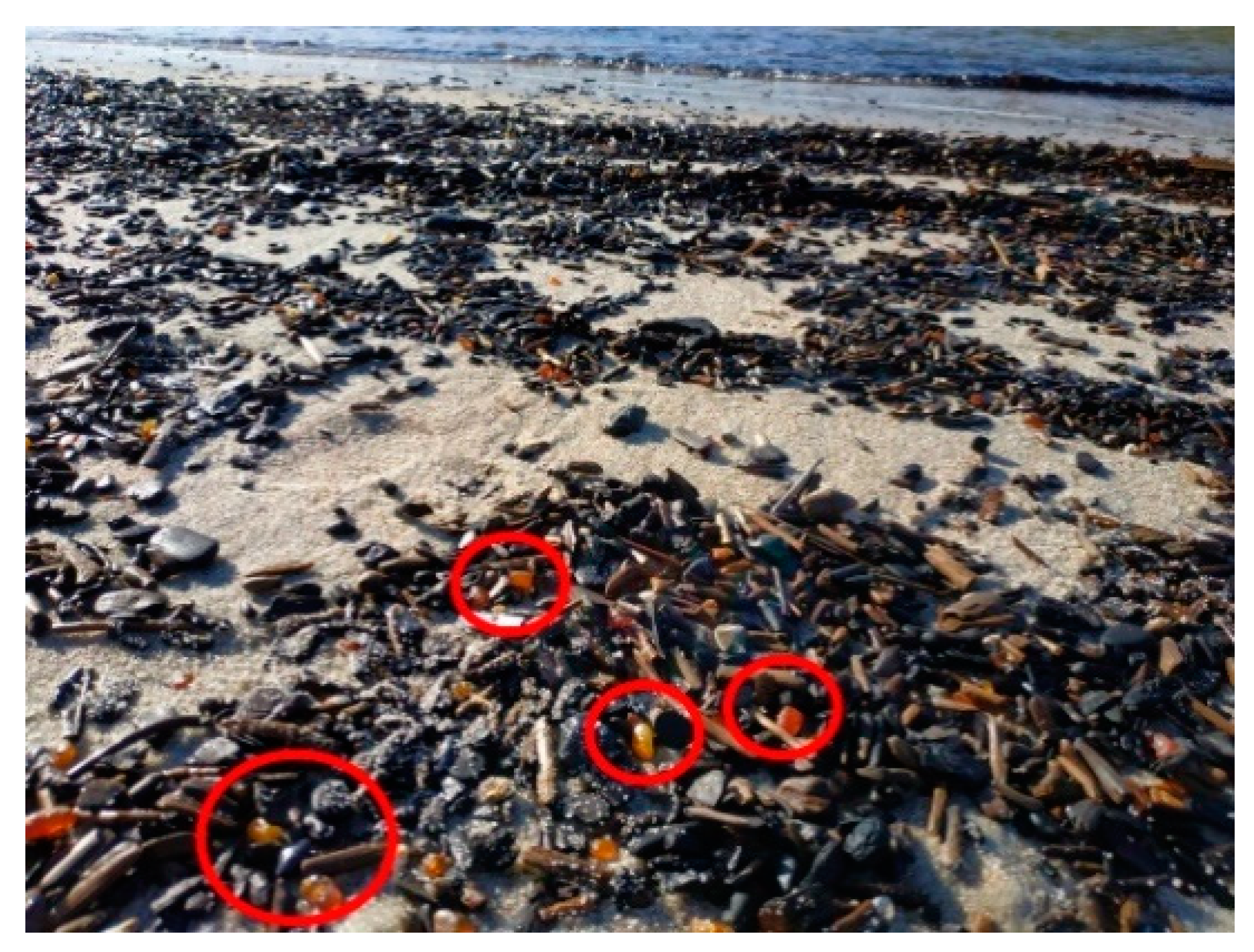
In the southeastern part of the Baltic Sea, massive wash-outs of marine flotsam have been experienced for centuries. It is known that such events are related to windy weather (e.g., [18]) and certain site-specific favorable conditions, but the exact location and time are still almost unpredictable. Recent monitoring by the Rake method [19] shows that under typical weather conditions, the abundance of anthropogenic macro-litter items (>2.5 cm) on the beaches of this region is, on average, 3.5 ± 4.6 items/m2 [5,20], while, in stormy wash-outs, it may reach 100–120 items/m2 (at the Vistula Spit, the Baltic Sea, I. Chubarenko, unpublished results) (Figure 1).
As follows from the considerations above, the prediction of anthropogenic litter wash-outs should be based upon analysis of two different sides of the problem: first, the development of a natural (stormy) situation favorable to the occurrence of the wash-out event; second, the amount of anthropogenic debris in the seaweed and litter patch seemingly related to human activity in the region, the proximity of rivers, cities, etc. Here, we concentrate on the first—i.e., the natural—aspect of the problem. The goals of this work are as follows: (i) to analyze the development of a number of meteorological and hydrophysical conditions preceding the massive wash-outs of marine debris on the shore of the Sambian Peninsula (southeastern part of the Baltic Sea); (ii) to determine recurring features and most influential physical parameters of general wind and wave patterns; (iii) to determine the required time period for analysis, which will be used as an input parameter of the ANN. The obtained relationship between meteorological and hydrophysical parameters is necessary for the development of the ANN structure, the formation of input data, and the further creation of a predictive model based on an ANN.

2. Materials and Methods

2.1. Study Area

The monitoring of wash-out spots on the beaches of the Sambian Peninsula had been carried out by scientists from the Shirshov Institute of Oceanology (IO RAS) since 2011. During this time, more than 250 cases of wash-outs of general marine debris with spots of anthropogenic litter were recorded; these wash-outs inevitably included plastic and microplastic particles.
Plastics were found in all marine litter spots surveyed after wash-outs. In samples taken on the northern coast of the Sambian Peninsula, the average concentration of plastic particles (>5 mm) was from 8 to 14 pieces/m2, and the maximum concentration was more than 100 particles items/m2 [21]. Under typical weather conditions, no litter spots are observed on the beach, and the level of contamination (by OSPAR method, >5 mm) indicates concentrations one order of magnitude smaller—from 0.3 to 1.5 items/m2 5]. In the northern part of the Sambian Peninsula, litter is dominated by artificial polymer (50%), paraffin (38.1%) cigarette butts (4.8%) and glass/ceramics (3.3%) [19].
From the reports on visual observations from open sources, it is not possible to determine the exact time of the beginning and end of the wash-out. Therefore, in the following analysis, the unified approximate time was used when the observers usually came to the shore, i.e., 12:00 local time (GMT + 2). During the visits of observers of the IO RAS near the Kulikovo village, for each observation, a detailed description of the place, time, and size of the wash-out spot was compiled. Additionally, the type of sediment (sand, small/coarse pebbles, boulders), the location of the wash-outs relative to the characteristic morphodynamic areas, the width of the beach, and the predominant species composition of macroalgae (for example, Furcellaria lumbricalis, Polysiphonia fucoides, or Cladofora glomerata) were recorded, with detailed photography.
Based on these data, it was possible to draw some additional conclusions about the wash-out event, based on the presence of algae on the beach, on the shoreface, in the water, and by their appearance. For example, if the algae are located in the water and at the water edge, the algae are shiny, elastic, have an integral structure (i.e., they are “fresh”); then, the wash-out is currently taking place. If the spot of algae is located on the beach and sprinkled with sand or pebbles (algae are pressed, dried, have a dull look), then the wash-out is more than 3 days old.
Microplastic particles have properties (size, density) similar to those of amber particles, which are known to beach the Sambian Peninsula [22]. It has been shown that when amber is washed out onto the seashore, a rush of anthropogenic litter is also observed (Figure 2) [23]. The Sambian peninsula, in general, and the Kulikovo village, in particular, are known for rich amber deposits. This gem attracts the attention of local residents and tourists, so massive wash-outs inevitably attract public attention and are often advertised on social networks and by media outlets. Knowing the natural connection between the wash-outs of marine debris and amber in this paper, we also used the data from open sources about these observations of the massive wash-outs of amber onto the beaches of the Sambian Peninsula. In the future, for the formation of the input parameters of the ANN, the data of the amber wash-outs are supposed to be used as an additional parameter.
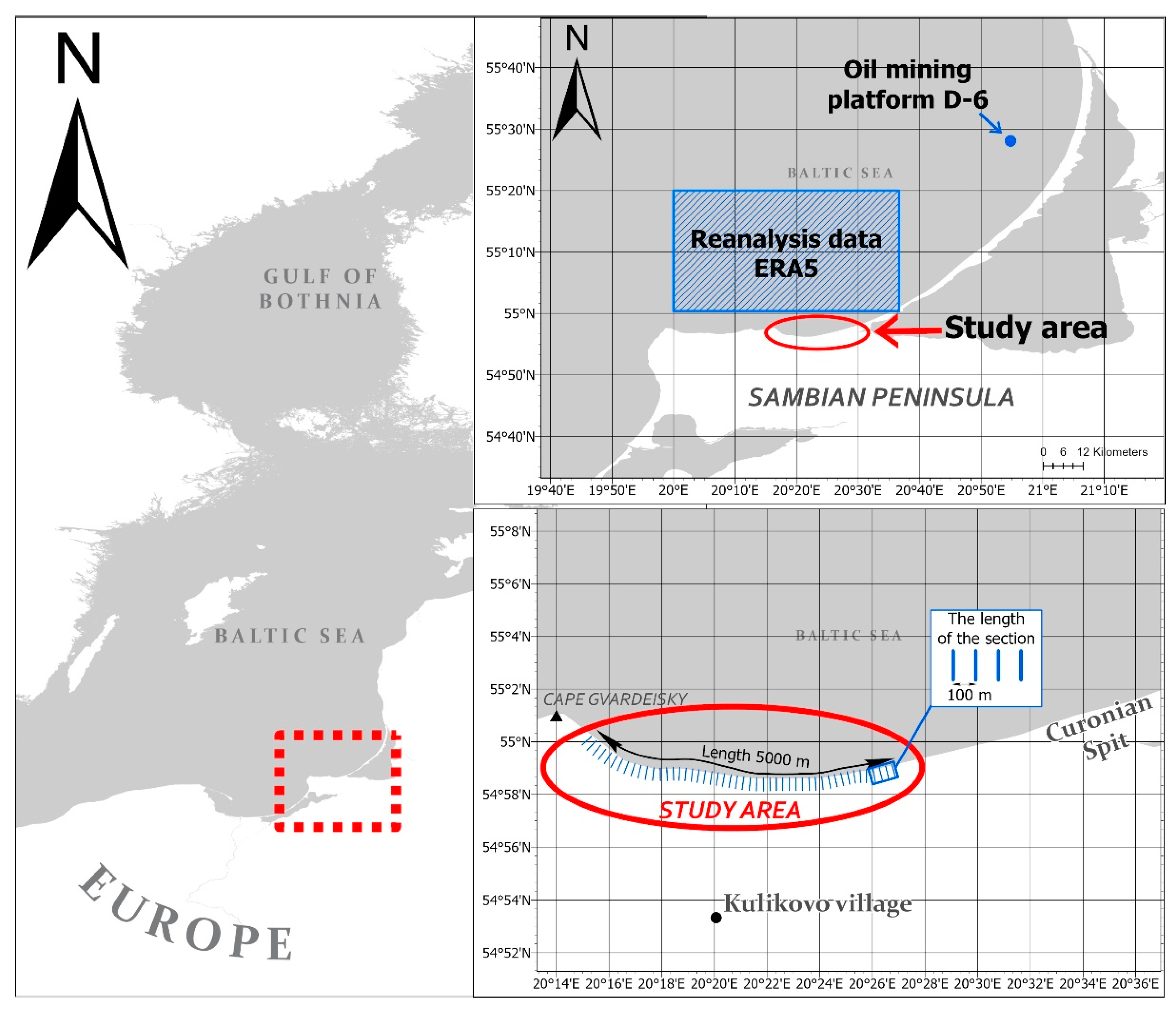
When choosing a specific site for the analysis, two criteria were applied: (i) the presence of a large enough set of observations of wash-outs; and (ii) the presence of a regular sandy underwater slope in the zone of deformation and the breaking of waves, which is required for the formation of a more or less uniform wave field. On the basis of these criteria, the beach of Kulikovo village of the Kaliningrad region (the length of about 5 km) was chosen as the study area among all the beaches of the Sambian Peninsula. This part of the shore is located between Cape Gvardeisky and the root of the Curonian Spit. In order to point out the location of the litter wash-out patch in further analysis, the beach of the study area was subdivided into sections 100 m in length (from west to east, starting from the Cape Gvardeisky), i.e., a total of 50 sections; see Figure 3. Since there are accurate GPS coordinates for each case of a wash-out, they can be related to a certain section, which will be the output value for the developed ANN.
During the observation period (2011–2019) on the shore of Kulikovo village, more than 58 cases of wash-out spots of marine debris were recorded. This is the maximum quantity among the other beaches of the Sambian Peninsula. Next, we selected the 25 most typical cases observed at different times of the year from 2013 to 2019, which were analyzed in detail in this work (Table 1). All the locations of the wash-outs are shown on the map (Figure 3). Selecting only one beach at the stage of analysis of natural drivers allowed us to exclude the possible influence of anthropogenic factors, such as proximity of settlements, inflowing rivers, fishing activity, etc., on the formation of a massive wash-out. In this paper, anthropogenic factors were not taken into account; however, in the future, their influence on the amount of anthropogenic litter in the mass of general marine debris should be considered.

2.2. Meteorological and Hydrophysical Data

Meteorological and hydrophysical data are used as input parameters of the ANN because they determine the situation as a whole. After training and testing the ANN, as well as collecting more detailed data of monitoring of anthropogenic litter as a part of a wash-out, the proximity of sources (rivers, settlements, fishing sites) should be considered.
The development of the meteorological and hydrophysical situation was analyzed for each of the 25 selected cases of massive wash-outs within 10 days before the respective wash-out events.
For the analysis of the meteorological situation, data related to wind speed and direction were considered, and they were obtained on the offshore ice-resistant oil mining platform D-6 (20.67° E, 55.28° N, Figure 2). This is located in the open sea at a depth of 30–35 m, 42 km off the northern shore, and was selected for our analysis. Wind measurements were performed with steps of 1 h at a height of 32 m; thus, before the analysis, the procedure for adjusting the speed values to the standard height of 10 m was applied according to the Formula (1):
W z W 10 = ( z z 10 ) p ,
where w z —wind speed at the height z; w 10 —wind speed at the height of 10 m; exponent p = 0.125. This method of reduction is common, and it is widely used by climatologists, forecasters, and engineers [24].
The hydrophysical situation was characterized by the development of surface waves according to the Copernicus reanalysis data [25]. The sea surface wave field was characterized by a combination of waves of different heights, lengths, and directions, which is known as a two-dimensional wave spectrum. The spectrum of waves can be decomposed into wind waves, which are directly driven by local winds, and swell, i.e., the waves that were created by the wind earlier or in another region. In this paper, the significant height of combined wind waves and swells was used for the analysis. The values of these significant waves’ height and direction, with the time step of 1 h, were analyzed within the 0.5° square (around the point 20° E, 55° N) and 10 days before each of the observed wash-outs of marine debris to the shore.

3. Results

In total, an analysis of the development of the hydro-meteorological situation in 25 cases of massive marine debris wash-outs on the shore of the Sambian Peninsula was carried out (Table 1). For the analysis of all cases, we used an observation period of 10 days before the wash-out event.

3.1. General Environmental Scenario

To develop an ANN model, it is necessary to understand how the meteorological and hydro-physical situation develops prior to the wash-out. Most of the observed cases of wash-outs (84%) developed following a similar scenario. As a typical case, No.5 of 15 January 2014 was chosen (Table 1): observers’ records confirm that the wash-out continued during the observation, i.e., large amounts of algae were found at the shoreface and in the water (Figure 4). Additionally, on this day, a wash-out of amber was observed. With the example of observation No.5, we consider the typical development of the hydrophysical and meteorological situation 10 days before the wash-out.
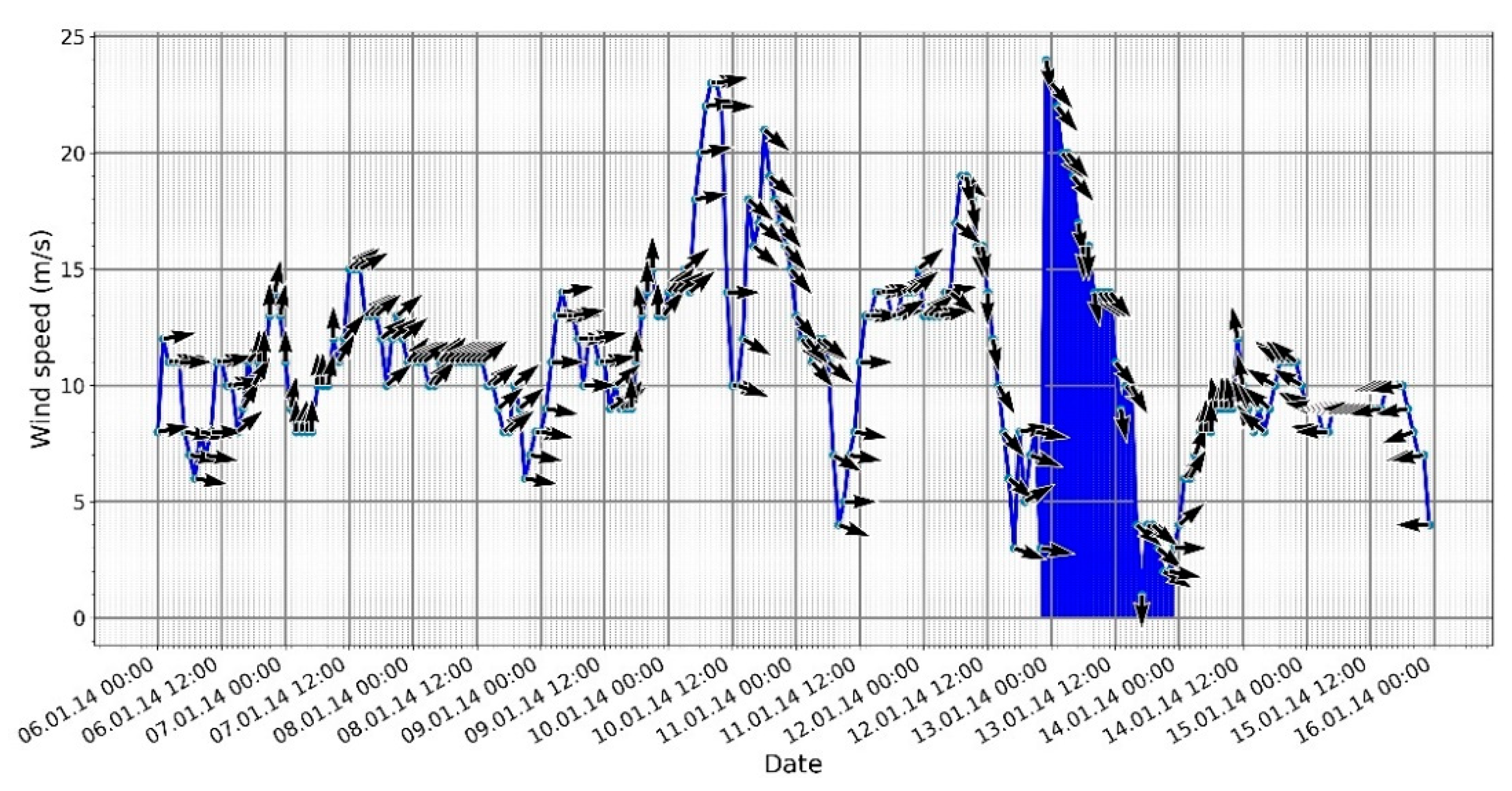
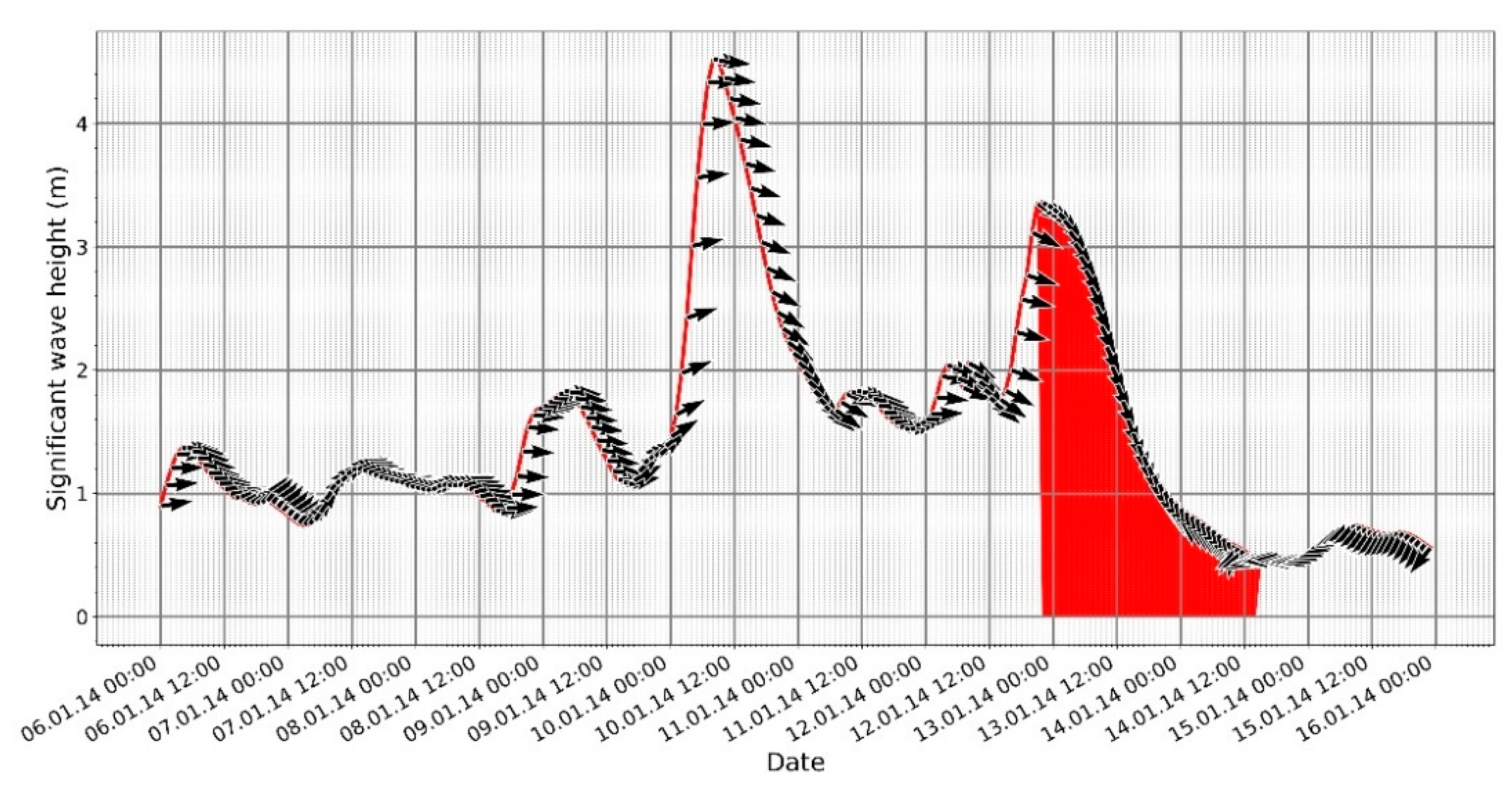
As can be seen from Figure 5, the wind speed began increasing from 21:00 (local, GMT + 2) on 8 January 2014; over 6 h, it increased from 6 to 14 m/s. Over this time, the wind direction changed from S-SW to the opposite, W-NW, and it remained the same until 08:00 a.m. on 12 January 2014. Over 4 days, wind subsidence down to 4 m/s and sharp increases up to 23 m/s were observed. A similar pattern was also observed in the development of surface waves (Figure 6). From 17:00 on 8 January 2014, the height of the significant waves, approaching the shore from western directions, began increasing. At the peak moments on 10 January 2015, the heights of the significant waves reached 4.4 m.
At 23:00 on 12 January 2015, the wind speed and the height of the significant waves began to decrease. Wind and wave directions smoothly changed from the west to the north; they became perpendicular to the considered shore toward the time of the wash-out event (Figure 5 and Figure 6).

3.2. Duration of the Modeling Period

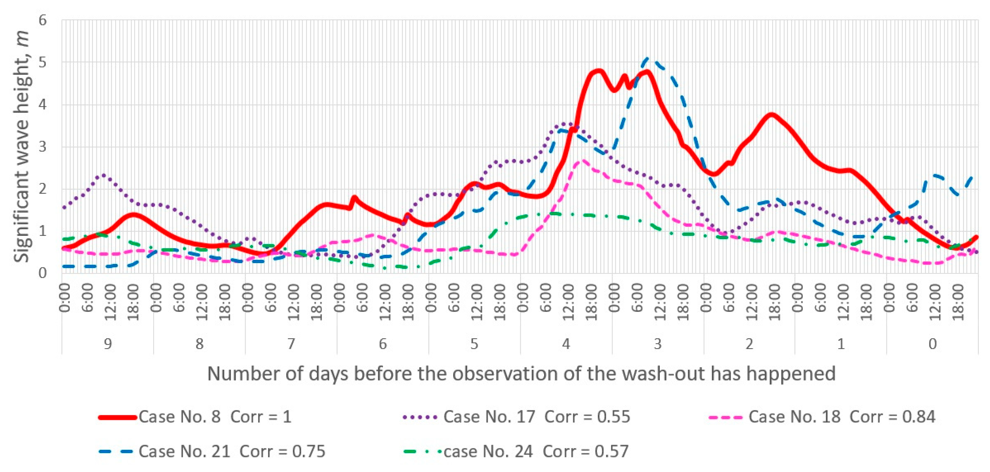
Based on the observations, assumptions were made about the main causes of the massive wash-out of marine debris, namely the phase of wind subsidence, a change in the direction of wind, and the wave height [11]. To confirm these parameters, as well as to determine whether there was a similarity between the developments of different wash-out situations, correlation matrices were calculated for each of the parameters considered in this work (Figures S1 and S2). Pairwise correlations were calculated using the Pearson criterion between the development in time of the parameters (wind, waves) observed during the formation of the wash-outs listed in Table 1. Each case of observation was represented as the set of values for 10 days with a step of 1 h (240 values, Figure 7).
The maximum correlation coefficients in the development of the wash-out situations were found for the following parameter: “significant wave height”. For example, in cases No. 8 and No. 18, the correlation coefficient was 0.84, and No.8 and No. 21 were 0.77 (Figure 7). Based on this, it can be concluded that developments of the wave field during wash-outs in different periods of observation are, to some extent, similar. Moreover, if the time interval is reduced to 5 days, then the correlation coefficient can reach 0.94 (e.g., for cases No.17 and 20).
Of course, there are pairs of cases with almost zero correlation (28.6% of the pairs under consideration have correlation coefficients in the range −0.2 < r < 0.2), i.e., with the absence, at a first glance, of a similarity in the development of the wave field; there are also pairs with a negative correlation (34.6% of the pairs under consideration have negative correlation coefficients r < −0.2), i.e., the opposite development trend. The reason for these might be the following:
(i)
Inaccuracy of binding observations to time: the wash-out ended before it was recorded. Observers can only state the fact of the presence of marine debris on the shore, while the wash-out could have happened earlier.
(ii)
Too long a time span was selected for correlation analysis. Indeed, with a decrease in the sampling period, a slight increase in the correlation coefficient was found.
There are various methods for analyzing wind and wave directions. For example, one method has been proposed by Walmsley and Bagg to solve the problem of the circular scale of wind direction and correlation [26]. In this paper, visual analysis of directions was used, with help from the “wind rose” for the wind direction and the “wave rose” for the wave direction.
As seen at Figure 8, during the observation period of cases No. 8, 18, and 21, the N-NW directions prevailed. If we take a closer look at Figure 6, it can be seen that for case No. 5, the subsiding phase was slightly less than 2 days, or 42 h (the period is highlighted on the graph). Throughout this period, the direction of the wave and wind was N-NW. For case No. 18, the subsiding phase was also 42 h and, for case No. 21, the subsiding phase was 52 h; all the cases had the same wave direction.
In terms of wind speed, we can also delineate the subsiding phase. The duration of this phase corresponds approximately to the duration of the wave subsiding phase. However, the wind direction is not so definite. Therefore, for example, for cases No. 8 and No. 21, the N-NW direction prevails, while for case No. 17, the eastern direction is pronounced; for case No. 9, the direction is from SE-SE.
Despite the fact that the correlation coefficient increases with a decrease in the time interval, we decided to use the period of exactly 10 days. During a storm, the western direction of the wind and waves predominates for a long time before the release. This is typical for the majority of cases considered in this work (72%). Therefore, a western wind can be considered one of the determining factors in the release of marine debris in the area studied in this paper.

3.3. Training Set

From the obtained characteristic picture of the formation of conditions for wash-out, it can be seen that the hydrodynamics exert an obvious influence; this influence is related to the height and direction of the significant waves in concomitance with the shore geomorphology. Based on this, the following conclusions can be drawn:
(i)
Wash-out is observed during the phase of the storm that is subsiding (decrease in significant wave height and wind speed). The duration of the subsiding phase is, on average, about 2 days (48 h).
(ii)
The mean direction of the significant wave during the entire subsiding phase is predominantly perpendicular to the shore (from N-NW for the considered beach).
(iii)
The minimum significant wave height value in the subsided phase at which the wash-out took place was, on average, about 0.58 ± 0.28 m.
Based on these conclusions, it is possible to form the input data for the ANN. In addition to the obvious parameters (wind speed and direction, height and direction of the significant wave), it is necessary to add the duration of the storm’s subsiding phase to the input data of the ANN, as it is one of the main factors that affects the release of marine debris.

3.4. ANN Basic Structure

For forecasting models in general, two AI techniques are the most popular: a decision tree (DT) and an artificial neural network (ANN). For the task of predicting the wash-outs of marine debris to the shore, the model of a multilayer perceptron network (MLPN) is more suitable [27,28]. It is a type of network in which each of the modules performs a weighted biased sum of their inputs and passes this activation level through a transfer function to receive their output. Modules are arranged in a multi-level feedforward topology. Thus, the network has a simple interpretation as a form of an input–output model, with weights and thresholds (biases). Such networks can simulate functions of almost arbitrary complexity [27].
Principally, it is necessary to perform the following steps for the creation of an ANN: (i) collecting input data; (ii) preprocessing of input data; (iii) building the network; (iv) training the network; (v) testing the network. In this paper, in addition to the obvious input data (wind speed, and the direction and the height and direction of the significant waves), we showed the importance of the duration of the storm with a predominantly westerly (for the considered testing region) wind. The length of the subsiding phase is also an important factor. These parameters were also chosen as input data for the ANN.
The input data must have a direct impact on the result the network produces; otherwise, errors in operation are inevitable. The use of original data can cause a convergence problem [27,29]. To avoid this, the original meteorological and hydrophysical data are converted to values from the interval (0:1). This representation of the data is called normalization. Here, the min–max normalization was used as a normalization method. Locations of the wash-out areas in output data (their GPS coordinates) are converted to the interval (1:50), in correspondence with their numbering within the study area (see Section 2.1 for detail). For the network to work correctly, the values of this interval must also be normalized.
Each input element of the neural network represents a vector of the form:
X i = ( x 1 , x 2 , x k ) ;
where x j —hourly values during the selected interval (10 days), k = 240. As described above, it is additionally necessary to normalize the data of vector X i to the range (0;1). A binary representation of the same vector X i will be used to set the duration of the storm and the phase of subsiding. That is, during the storm phase, x j   = 1; otherwise, x j = 0. This is similar for the subsiding phase of the storm.
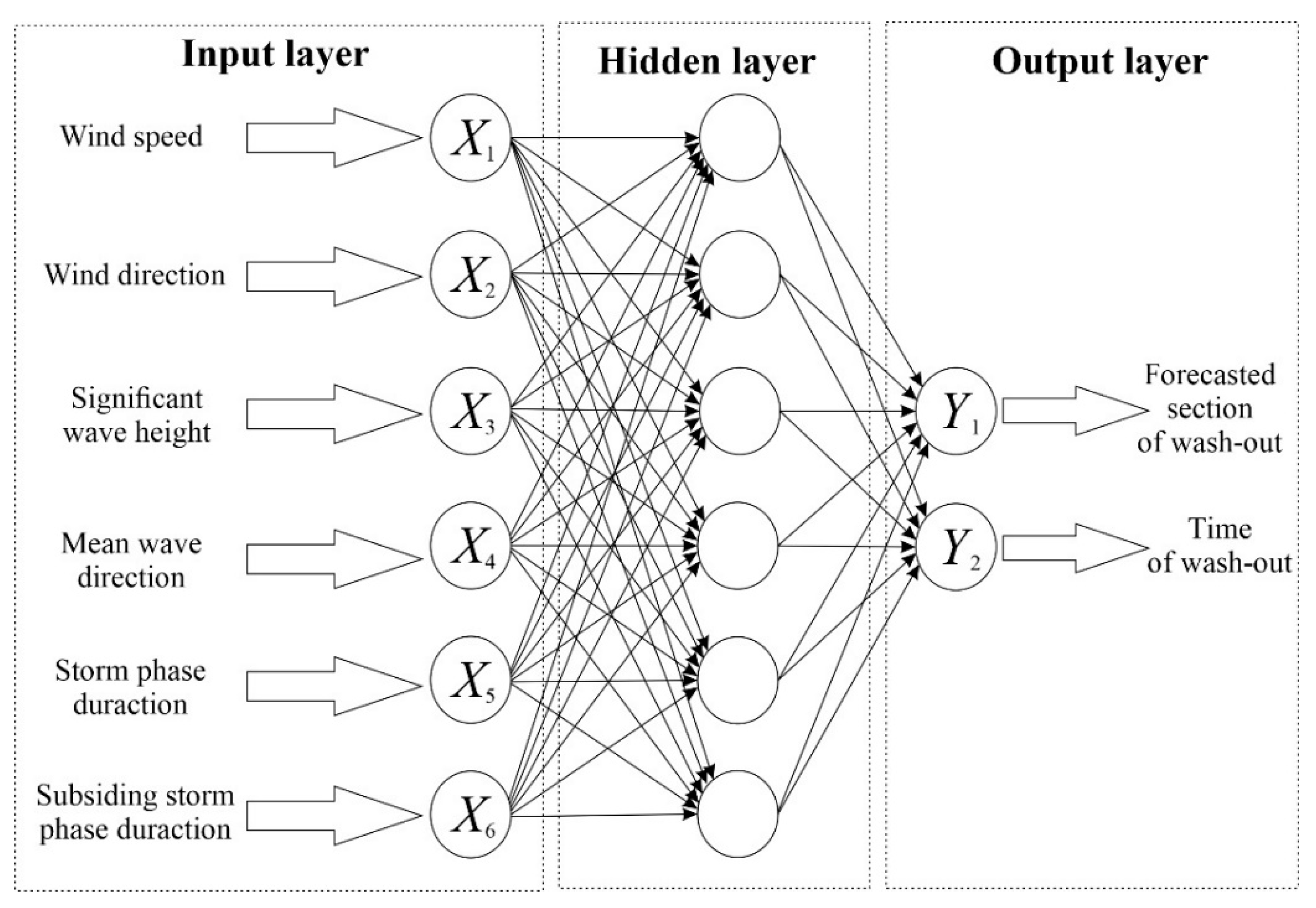
The output layer of the network consists of two elements: Y 1   ∈ (0;1)—forecasted section of wash-out; и Y 2   ∈ (0;1)—time of wash-out. After the network starts working, the received data must be denormalized.
To solve the problem of forecasting the wash-out of marine debris, a three-layered neural network was developed (input layer, hidden layer, and output layer) comprising a nonlinear sigmoid transfer function for the hidden layer and a linear transfer function for the output layer (Figure 9). It is this network structure that has shown the best results in practice, such as in the case of predicting upwelling [28].

4. Discussion

Massive wash-outs of marine debris on the shore of the Sambian Peninsula are traditionally associated with wind direction [11]. Therefore, prior to the analysis of specific cases of wash-outs, including those used in this paper, it was assumed that the key factor influencing the wash-outs of marine debris from the sea to the shore was the direction of the wind and the exposition of the particular shoreline. Historical sources describing wash-outs of amber on the shore of the Sambian Peninsula claimed that this phenomenon was observed in the presence of a wind that was directed perpendicularly to the shore [30]. However, as is evident from our analysis, this was not always the case. The direction of significant waves happened to be much more characteristic.
The influence of waves on the wash-outs of marine debris is evident while the storm is subsiding. However, before this phase, in almost all the cases, there was a long period in which the direction of the significant wave was westerly. Apparently, this is due to the exposure of the selected study site, as suggested by similar studies on the western shore of the Sambian Peninsula. At the same time, storms from W and SW are typical for the considered area. This might suggest that the role of the storm itself (i.e., before its subsiding phase) supports energetic mixing that is strong enough to tear seagrasses off their roots; this process does not generally depend on wind direction.
The structure of the ANN is individual for each task. Only by experimental methods is it possible to determine network parameters such as the number of hidden layers or activation functions. Additionally, although the model proposed in this article is the most optimal for a task such as forecasting, only further fine tuning will help to minimize errors as much as possible.
The data obtained as a result of this work are obviously necessary but probably not sufficient to create a predictive ANN model of marine litter wash-outs (in its natural aspect). For example, in addition to the hydrophysical parameters described in this work, the wash-out may be influenced by the speed and direction of currents in the coastal zone. According to preliminary data, the wash-outs of marine debris may coincide with the formation of rip currents in coastal zones [31]. If so, the discussed predictive system may also be used to inform people about this dangerous phenomenon.
In creating of a scientifically based marine litter monitoring system, further field and modeling efforts are required for the following: (i) to predict the share of anthropogenic litter among the beached items; (ii) to evaluate the residence time of litter on the shoreline.

5. Conclusions

The development of hydrophysical situations that lead to a large wash-outs of marine debris on the Baltic Sea shore is disclosed. The wave subsiding phase after storms is the most important parameter; its duration is about 48 h. During this time, the heights and directions of the significant waves in all the considered cases developed in a similar manner. These parameters should be considered as the most valuable for the formation of marine debris wash-outs, and they were used as input data for the ANN to develop a forecasting system.

Supplementary Materials

The following are available online at https://www.mdpi.com/article/10.3390/pollutants1030013/s1, Figure S1: The correlation matrices for significant waves height over a period of 10 days, Figure S2: The correlation matrices for wind speed over a period of 10 days.

Author Contributions

Conceptualization, S.F. and I.C.; methodology, S.F. and I.C.; software, S.F.; validation, S.F. and I.C.; formal analysis, S.F.; investigation, S.F.; resources, S.F.; data curation, S.F.; writing—original draft preparation, S.F.; writing—review and editing, I.C.; visualization, S.F.; supervision, I.C.; project administration, I.C.; funding acquisition, I.C. All authors have read and agreed to the published version of the manuscript.

Funding

This research was funded by the IKBFU competitiveness improvement program for 2016–2020 (project 5–100). Meteorological data is collected in the framework of the state assignment of Shirshov Institute of Oceanology RAS No. 0128-2021-0012. Observations of the wash-outs of marine debris to the shore are supported by the Russian Science Foundation, grant No. 19-17-00041.

Acknowledgments

The authors are grateful to “LUKOIL-Kaliningradmorneft” and Zh. Stont for the meteorological information provided.

Conflicts of Interest

The authors declare no conflict of interest.

References

  1. UNEP. Marine Plastic Debris and Microplastics-Global Lessons and Research to In-Spire Action and Guide Policy Change; United Nations Environment Program: Nairobi, Kenya, 2016; Available online: www.unep.org (accessed on 5 October 2020).
  2. Boucher, J.; Friot, D. Primary Microplastics in the Oceans: A Global Evaluation of Sources; IUCN: Gland, Switzerland, 2017; p. 43. [Google Scholar]
  3. Lebreton, L.C.; Van Der Zwet, J.; Damsteeg, J.W.; Slat, B.; Andrady, A.; Reisser, J. River plastic emissions to the world’s oceans. Nat. Commun. 2017, 8, 1–10. [Google Scholar] [CrossRef]
  4. Wibowo, Y.G.; Maryani, A.T.; Dewi Rosanti, D.; Rosarina, D. Microplastic in Marine Environment and Its Impact. Sainmatika 2019, 16, 81–87. [Google Scholar] [CrossRef] [Green Version]
  5. Chubarenko, I.; Esiukova, E.; Khatmullina, L.; Lobchuk, O.; Grave, A.; Kileso, A.; Haseler, M. From macro to micro, from patchy to uniform: Analyzing plastic contamination along and across a sandy tideless coast. Mar. Pollut. Bull. 2020, 156, 111198. [Google Scholar] [CrossRef] [PubMed]
  6. Urbanek, A.K.; Rymowicz, W.; Mirończuk, A.M. Degradation of plastics and plastic-degrading bacteria in cold marine habitats. Appl. Microbiol. Biotechnol. 2018, 102, 7669–7678. [Google Scholar] [CrossRef] [Green Version]
  7. Ragusa, A.; Svelato, A.; Santacroce, C.; Catalano, P.; Notarstefano, V.; Carnevali, O.; Papa, F.; Rongioletti, M.; Baiocco, F.; Draghi, S.; et al. Plasticenta: First evidence of microplastics in human placenta. Environ. Int. 2021, 146, 106274. [Google Scholar] [CrossRef] [PubMed]
  8. Critchell, K.; Lambrechts, J. Modelling accumulation of marine plastics in the coastal zone; what are the dominant physical processes? Estuar. Coast. Shelf Sci. 2016, 171, 111–122. [Google Scholar] [CrossRef]
  9. Rosas, E.; Martins, F.; Janeiro, J. Marine Litter on the Coast of the Algarve: Main Sources and Distribution Using a Modeling Approach. J. Mar. Sci. Eng. 2021, 9, 412. [Google Scholar] [CrossRef]
  10. Ypma, S.; Kaandorp, M.; Jones, J.; Donnelly, A.; van Sebille, E. Using machine learning techniques to predict beaching of marine debris on the Galapagos Islands. In Proceedings of the EGU General Assembly Conference Abstracts, online, 19–30 April 2021; p. EGU21-274. [Google Scholar] [CrossRef]
  11. Chubarenko, I.; Stepanova, N. Microplastics in sea coastal zone: Lessons learned from the Baltic amber. Environ. Pollut. 2017, 224, 243–254. [Google Scholar] [CrossRef]
  12. Gómez-Pujol, L.; Orfila, A.; Álvarez-Ellacuría, A.; Terrados, J.; Tintoré, J. Posidonia oceanica beach-cast litter in Mediterranean beaches: A coastal videomonitoring study. J. Coast. Res. 2013, 65, 1768–1773. [Google Scholar] [CrossRef] [Green Version]
  13. Van Sebille, E.; Griffies, S.M.; Abernathey, R.; Adams, T.P.; Berloff, P.; Biastoch, A.; Blanke, B.; Chassignet, E.P.; Cheng, Y.; Cotter, C.J.; et al. Lagrangian ocean analysis: Fundamentals and practices. Ocean Model 2018, 121, 49–75. [Google Scholar] [CrossRef]
  14. Martyanov, S.D.; Ryabchenko, V.A.; Ershova, A.A.; Eremina, T.R.; Martin, G. On the assessment of microplastic distribution in the eastern part of the Gulf of Finland. Fundam. I Prikl. Gidrofiz. 2019, 12, 32–41. [Google Scholar] [CrossRef]
  15. Schulz, M.; Matthies, M. Artificial neural networks for modeling time series of beach litter in the southern North Sea. Mar. Environ. Res. 2014, 98, 14–20. [Google Scholar] [CrossRef]
  16. Agarwala, N. Managing marine environmental pollution using Artificial Intelligence. Marit. Technol. Res. 2021, 3, 120–136. [Google Scholar] [CrossRef]
  17. Franceschinia, S. Rummaging through the bin: Modeling marine litter distribution using Artificial Neural Networks. Mar. Pollut. Bull. 2019, 149, 110580. [Google Scholar] [CrossRef]
  18. Esiukova, E. Plastic pollution on the Baltic beaches of the Kaliningrad region, Russia. Mar. Pollut. Bull. 2017, 114, 1072–1080. [Google Scholar] [CrossRef]
  19. Haseler, M.; Balciunas, A.; Hauk, R.; Sabaliauskaite, V.; Chubarenko, I.; Ershova, A.; Schernewski, G. Marine Litter Pollution in Baltic Sea Beaches—Application of the Sand Rake Method. Front. Environ. Sci. 2020, 8, 238. [Google Scholar] [CrossRef]
  20. Esiukova, E.; Khatmullina, L.; Lobchuk, O.; Grave, A.; Kileso, A.; Haseler, M.; Zyubin, A.; Chubarenko, I. From macro to micro: Dataset on plastic contamination along and across a sandy tideless coast (the Curonian Spit, the Baltic Sea). Data Brief 2020, 30, 105635. [Google Scholar] [CrossRef]
  21. Esiukova, E.; Chubarenko, I.; Volodina, A.; Bykanova, T. Littering of marine coasts after severe storms. In Proceedings of the 12th Baltic Sea Science Congress 2019 (BSSC 2019), Stockholm, Sweden, 19–23 August 2019; p. 243. [Google Scholar]
  22. Chubarenko, B.; Woelfel, J.; Hofmann, J.; Aldag, S.; Beldowski, J.; Burlakovs, J.; Garrels, T.; Gorbunova, J.; Guizani, S.; Kupczyk, A.; et al. Converting beach wrack into a resource as a challenge for the Baltic Sea (an overview). Ocean Coast. Manag. 2021, 200, 20–26. [Google Scholar] [CrossRef]
  23. Chubarenko, I.; Esiukova, E.; Bagaev, A.; Isachenko, I.; Demchenko, N.; Zobkov, M.; Efimova, I.; Bagaeva, M.; Khatmullina, L. Behavior of Microplastics in Coastal Zones. In Microplastic Contamination in Aquatic Environments; Eddy, Y.Z., Ed.; Elsevier: Amsterdam, The Netherlands, 2018; pp. 175–223. ISBN 9780128137475. [Google Scholar] [CrossRef]
  24. Nesterova, E.S. Mode, Diagnosis and Forecast of Wind Waves in the Seas and Oceans: Scientific and Methodological Manual; Respiratory, Ed.; MCC of Roshydromet, Research Group “Social Sciences”: Moscow, Russia, 2013; p. 337. [Google Scholar]
  25. Hersbach, H.; Bell, B.; Berrisford, P.; Biavati, G.; Horányi, A.; Muñoz Sabater, J.; Nicolas, J.; Peubey, C.; Radu, R.; Rozum, I.; et al. ERA5 hourly data on single levels from 1979 to present. Copernicus Climate Change Service (C3S) Climate Data Store (CDS). ECMWF 2018, 147, 5–6. [Google Scholar] [CrossRef]
  26. Walmsley, J.L.; Bagg, D.L. A method of correlating wind data between two stations with application to the Alberta oil sands. Atmos. Ocean 1978, 16, 333–347. [Google Scholar] [CrossRef]
  27. Litta, A.J.; Idicula, S.M.; Mohanty, U.C. Artificial Neural Network Model in Prediction of Meteorological Parameters during Premonsoon Thunderstorms. Int. J. Atmos. Sci. 2013, 2013. [Google Scholar] [CrossRef]
  28. Bouzegag, C.; Bouzid-Lagha, S. Forecasting the upwelling phenomenon using an artificial neural network. Pol. J. Soil Sci. 2020, 53, 245–259. [Google Scholar] [CrossRef]
  29. Khan, M.R.; Ondrusek, C. Short-term electric demand prognosis using artificial neural networks. Electr. Eng. 2000, 51, 296–300. [Google Scholar]
  30. Savkevich, S.S. Amber; Nedra: Leningrad, Russia, 1970; p. 192. [Google Scholar]
  31. Schönhofer, J.; Dudkowska, A. Rip currents in the southern Baltic Sea multi-bar near-shore zone. Cont. Shelf Res. 2021, 212, 104324. [Google Scholar] [CrossRef]
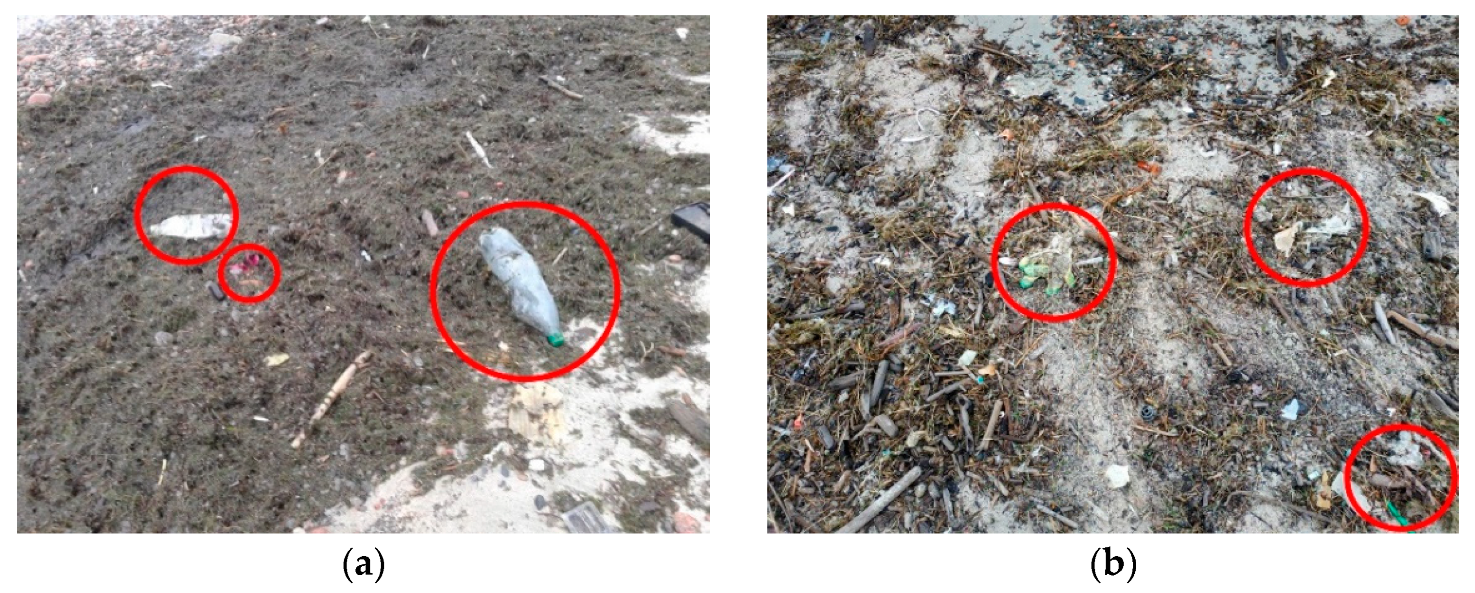
Figure 1. Photos of the beach in the Kulikovo village with a massive wash-outs of marine debris: (a) plastic bottles and (b) other plastic and anthropogenic litter (highlighted by red circles).
Pollutants 01 00013 g001
Figure 2. Example of marine debris wash-out with amber.
Pollutants 01 00013 g002
Figure 3. Study area in southeastern part of the Baltic Sea.
Pollutants 01 00013 g003
Figure 4. The photo of wash-out for case No.5: (a) Section 1. A narrow strip 1–1.5 m wide, about 100 m long; (b) Section 2. A narrow strip, turning into spots up to 6–8 m wide, about 400 m long.
Pollutants 01 00013 g004
Figure 5. Change in wind speed (graph) and wind direction (arrows) from 6 January 2014 to 16 January 2014.
Pollutants 01 00013 g005
Figure 6. Change in the height (graphs) and direction (arrows) of the significant waves from 6 January 2014 to 16 January 2014.
Pollutants 01 00013 g006
Figure 7. Variations in the significant wave height for cases No. 8, 17, 18, 21, and 24 10 days before the wash-out event. The curves are synchronized using the time of the wash-out event (right-hand side, day 0). Coefficients of correlation with the development of wave situation are shown relatively occasions case No. 8.
Pollutants 01 00013 g007
Figure 8. Roses of the distribution of the direction of the significant wave for 5 days before the moment of observation: (a) for case No. 8; (b) for case No. 18; (c) for case No. 21.
Pollutants 01 00013 g008
Figure 9. The ANN structure for analysis of natural conditions.
Pollutants 01 00013 g009
Table 1. Parameters of meteorological and hydrophysical conditions at 12:00 local time (GMT + 2) for each observation.
No.Date of the Observed CastWind Speed at Height of 10 m, m/sWind Direction, DegreesSignificant Waves Height, mMean Wave
Direction, Degrees
113 April 20133.52300.52270
212 June 20134.32300.28296
314 September 20136.9900.6550
424 November 20136.92600.93293
515 January 20147.8800.7054
630 March 20142.6500.117
727 September 20146.12900.75292
86 January 20152.61100.505
924 January 20156.11800.47320
1031 October 20155.21600.27166
1121 November 20152.61000.50354
125 December 201514.72402.13262
1310 January 20164.31300.76132
1412 January 20165.2200.582
1516 January 20163.53600.61350
1618 June 201611.22501.66276
179 October 20167.81001.0064
184 June 2017000.2396
199 January 20185.22300.57298
2016 June 20181.72800.24293
2127 October 201812.12602.32263
224 November 20186.11600.45120
234 January 20195.22801.50297
2413 April 20193.5500.6745
254 August 20195.23400.59357
Publisher’s Note: MDPI stays neutral with regard to jurisdictional claims in published maps and institutional affiliations.