Proceeding Paper

Modeling Wheat Height from Sentinel-1: A Cluster-Based Approach †

by
Andrea Soccolini
1,*,
Francesco Saverio Santaga
2 and
Sara Antognelli
2
1
Department of Civil, Construction and Environmental Engineering, University of Rome, 00185 Rome, Italy
2
Agricolus S.R.L., 06129 Perugia, Italy
*
Author to whom correspondence should be addressed.
Presented at the 1st International Conference on Advanced Remote Sensing (ICARS 2025), Barcelona, Spain, 26–28 March 2025; Available online: https://sciforum.net/event/ICARS2025.
Eng. Proc. 2025, 94(1), 7; https://doi.org/10.3390/engproc2025094007
Published: 11 July 2025

Abstract

Crop height is a key indicator of plant development and growth dynamics, offering valuable insights for temporal crop monitoring. However, modeling its variation across phenological stages remains challenging due to canopy structural changes. This study aimed to predict wheat height throughout the growth cycle by integrating radar remote sensing data with a phenology-informed clustering approach. The research was conducted in three wheat fields in Umbria, Italy, from 30 January to 10 June 2024, using in-field height measurements, phenological observations, and Sentinel-1 acquisitions. Backscatter variables (VH, VV, and CR) were processed using two speckle filters (Lee 7 × 7 and Refined Lee), alongside additional radar-derived parameters (entropy, anisotropy, alpha, and RVI). Fuzzy C-means clustering enabled the classification of observations into two phenological groups, supporting the development of stage-specific linear regression models. Results demonstrated high accuracy during early growth stages (tillering to stem elongation), with R2 values of 0.76 (RMSE = 6.88) for Lee 7 × 7 and 0.79 (RMSE = 6.35) for Refined Lee. In later stages (booting to maturity), model performance declined, with Lee 7 × 7 outperforming Refined Lee (R2 = 0.51 vs. 0.33). These findings underscore the potential of phenology-based modeling approaches to enhance crop height estimation and improve radar-driven crop monitoring.

Graphical Abstract

1. Introduction

Understanding crop development through remote sensing constitutes a fundamental objective within the domain of precision agriculture, aiming to support optimized field monitoring and informed management decisions. The retrieval of crop biophysical parameters from Synthetic Aperture Radar (SAR) data presents a valuable opportunity in this context, offering cloud-independent monitoring capabilities and enabling the continuous assessment of vegetation dynamics [1]. Among these parameters, plant height serves as a critical indicator of vegetative development and above-ground biomass accumulation. However, its accurate estimation from SAR observations remains a significant challenge due to the inherently complex and non-linear interactions between microwave signals and canopy structural characteristics [2].
Various methodological approaches have been explored for estimating crop height using SAR data. Among machine learning techniques, Random Forest algorithms have demonstrated considerable efficacy in the estimation of wheat height, often employing VV backscatter either alone or in conjunction with polarimetric features [3,4,5]. Furthermore, the study by Nduku et al. [6] underscored the enhanced predictive capacity achievable through the integration of Sentinel-1 and Sentinel-2 datasets, reporting superior performance when employing Random Forest Regression and Support Vector Machine models. Despite their conceptual simplicity, linear regression models have also been investigated as feasible alternatives for modeling the relationship between SAR backscatter and field-based crop height observations [7,8].
Although it is well documented that phenology can significantly influence SAR backscatter, this factor is frequently not explicitly accounted for in existing modeling frameworks. Clustering techniques—used to group observations based on feature similarity or distance—can address this limitation by organizing data into more homogeneous subsets, potentially improving both model performance and interpretability [9]. Traditional clustering approaches, such as K-Means, assign each observation exclusively to a single group, resulting in crisp partitions based on Euclidean distance. In contrast, fuzzy clustering algorithms allow for soft assignment, making them more suitable for these purposes.
Hence, this research proposes a methodology for estimating wheat height from SAR-derived parameters by partitioning the dataset into phenologically similar clusters using fuzzy C-Means clustering. Within each cluster, wheat height is then predicted using multiple linear regression, with the goal of enhancing model accuracy and capturing variability due to phenological development.

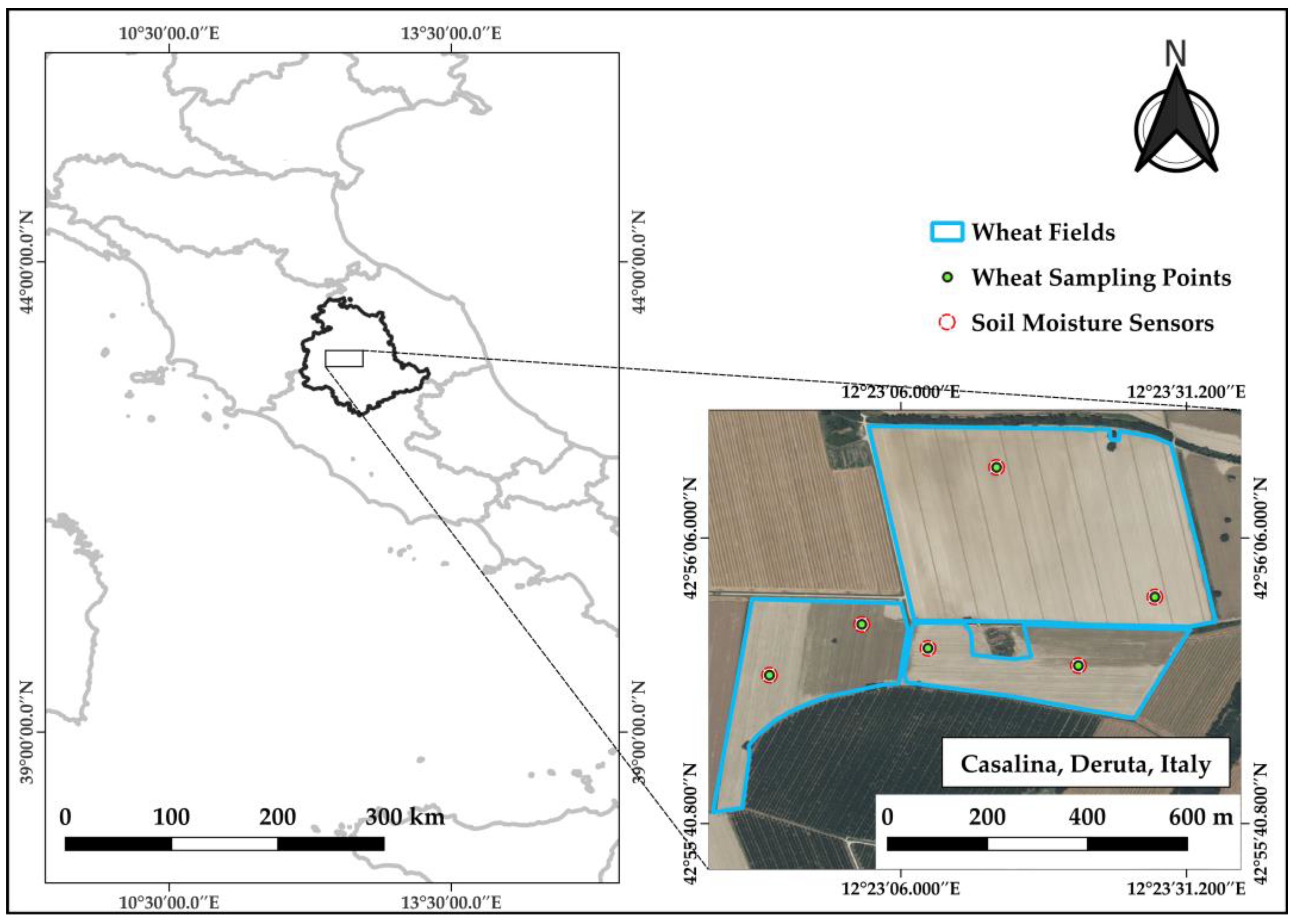
2. Materials and Methods

The experimental study was carried out across three agricultural fields managed by the “Foundation of Agricultural Education in Perugia” (Figure 1), located in Casalina, Deruta, Italy, near the Tiber Valley (158 m a.s.l., 42°56′16″ N, 12°23′34″ E). The target crop was soft wheat (Triticum aestivum L., var. Vivendo), sown between 2 and 6 November 2023, and harvested from 23 to 29 June 2024.
To capture within-field variability in crop development, two representative sampling locations were selected in each field using historical vegetation vigor maps and soil texture data. These points were positioned in zones characterized by contrasting canopy vigor. Around each sampling point, within a 5 m buffer, the average height of ten wheat plants was measured, alongside assessments of phenological stage and canopy vigor. Phenological stages were classified according to the BBCH scale [10]. At each sampling location, six soil moisture sensors were installed at a depth of approximately 20 cm to continuously monitor volumetric water content every 15 min throughout the growing season.
To complement ground-based measurements, eleven Sentinel-1 images were acquired from the Copernicus Data Space Ecosystem [11] between 30 January 2024 and 10 June 2024. Among the available acquisition tracks (Ascending 117, Descending 22, and Descending 95), Ascending 117 was selected due to its optimal overpass time (~17:30 local time), which helps minimize signal interference from dew. Both Ground Range Detected (GRD) and Single Look Complex (SLC) products were collected and processed using ESA SNAP software [12].
Containing only amplitude information, GRD images were subjected to standard pre-processing steps [13], including orbit correction, thermal noise removal, and radiometric calibration to convert digital numbers (DNs) to sigma nought (σ0) backscatter coefficients. Speckle noise was mitigated using two filtering techniques (Lee 7 × 7 and Refined Lee). The images were then ortho-rectified using the SRTM three arcsecond Digital Elevation Model (DEM).
SLC products, which retain both amplitude and phase information, underwent the following more advanced pre-processing workflow [14]:
  • Application of precise orbit file;
  • TOPSAR splitting;
  • Radiometric calibration to convert integer DN to complex values;
  • TOPSAR debursting;
  • Generation of polarimetric coherence matrix (C2);
  • Multi-looking (four range × one azimuth);
  • Polarimetric speckle filtering (Refined Lee 5 × 5);
  • Ortho-rectification.
The linear σ0 values were converted to decibels (dB) using the following logarithmic transformation:
σ0 (dB) = 10 ∗ log10 σ0
For both vertical–horizontal (VH) and vertical–vertical (VV) polarization channels. Additionally, the cross-ratio was computed as follows:
σ0 (CR) = σ0 (VH) − σ0 (VV)
Polarimetric decomposition was performed using a modified Cloude–Pottier algorithm to derive entropy (H), anisotropy (A), and the alpha angle (α) [15]. The dual-polarization Radar Vegetation Index (RVI) was also calculated using the following formula [16]:
RVI = 4 ∗ σ0 VH/(σ0 VH + σ0 VV)
All derived SAR variables had a spatial resolution of 10 m × 10 m. To streamline analysis and optimize computational efficiency, a spatial subset of the area of interest (AOI) was used. SAR-derived parameters were extracted at each sampling location using spatial overlays in QGIS.
To explore the relationship between SAR parameters and wheat height, a fuzzy C-Means (FCM) clustering algorithm was implemented in Python v. 3.11.5. Unlike hard clustering approaches, FCM assigns each observation a membership score across clusters, minimizing the weighted within-cluster variance [17]. This soft assignment strategy may take into account the gradual progress of phenology, which rarely follows strict boundaries but rather exhibits overlapping structural traits across growth stages. Following clustering, linear correlation analyses were performed between wheat height and individual SAR variables within each group. Parameters showing statistically significant correlations (p < 0.05) were selected to build multiple linear regression models for height estimation, tailored to each cluster. Model performance was evaluated using the coefficient of determination (R2) and root mean square error (RMSE), enabling the assessment of predictive accuracy across phenologically subgroups.
The temporal evolution of SAR backscatter throughout the wheat growth cycle reflects the dynamic interplay between soil and vegetation contributions. VV polarization is particularly sensitive to soil moisture and surface roughness, especially during early growth when vegetation cover is minimal, whereas VH polarization becomes more responsive as the crop canopy develops, being influenced by structural complexity [18]. In the early stages, such as tillering, backscatter is dominated by soil signals due to sparse vegetation. As the crop enters stem elongation, increased vertical biomass (e.g., stems and leaves) causes signal attenuation, typically resulting in minimum backscatter around the booting stage [19]. Later stages, including heading and flowering, introduce more complex scattering mechanisms due to reproductive structures like ears and awns. These lead to volume and double-bounce scattering effects, making the SAR response more randomized and difficult to interpret using simple backscatter metrics alone. Polarimetric decomposition metrics help to contextualize these dynamics. Entropy (H), which quantifies the randomness of scattering, increases with canopy density, indicating the transition from surface-dominated to volume-dominated scattering. The alpha angle (α), representing the dominant scattering mechanism, shifts from low values (surface scattering) to higher ones typical of volume scattering as vegetation becomes more structurally complex [20].

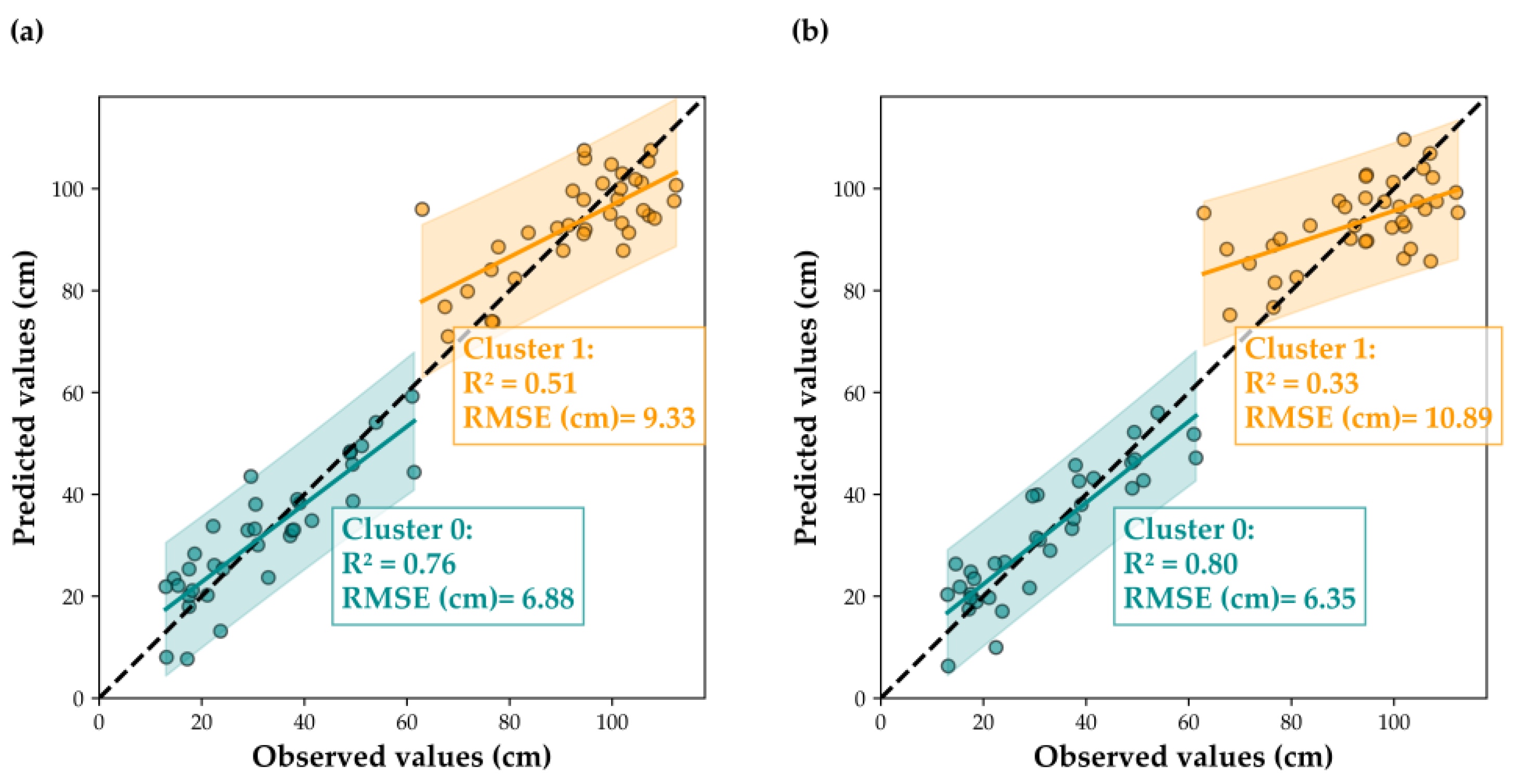
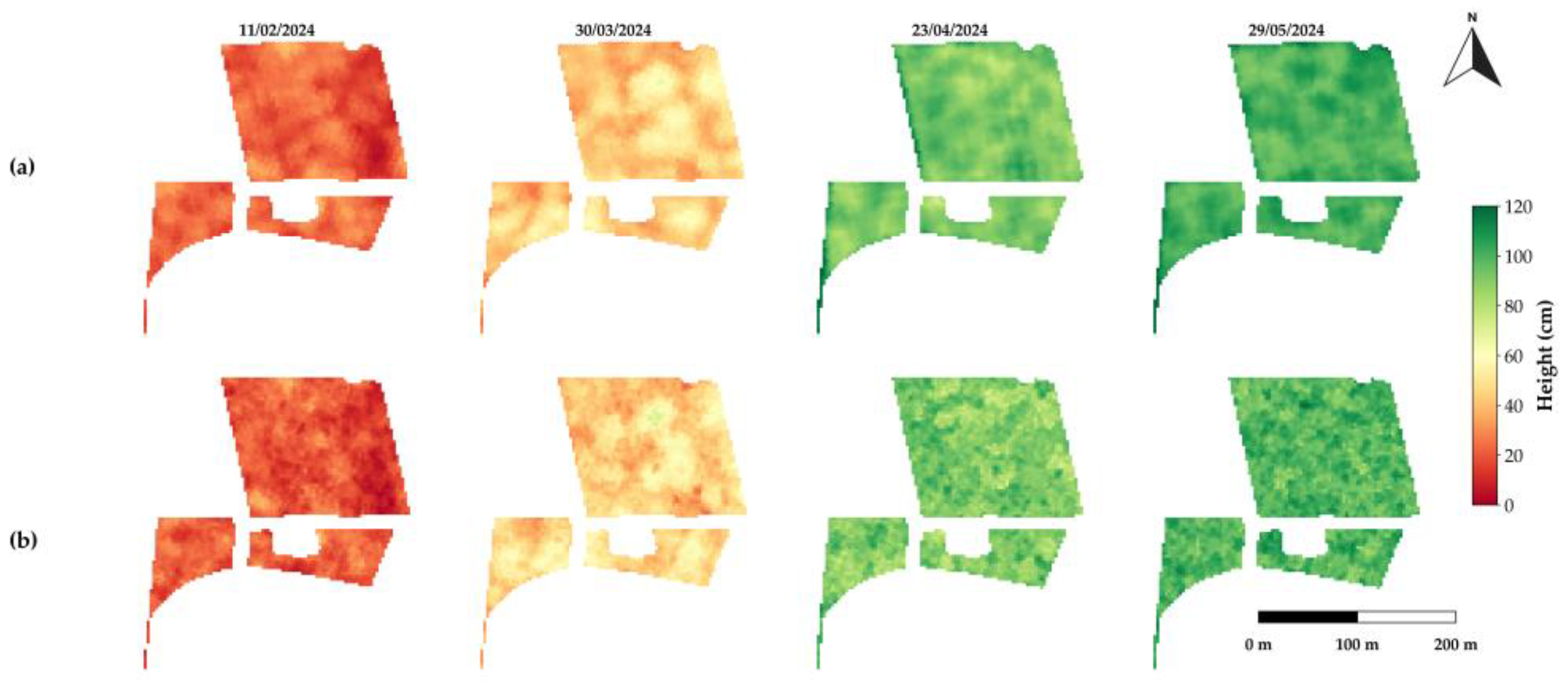
3. Results and Discussion

The application of fuzzy C-Means (FCM) clustering enabled the identification of two distinct phenological clusters: the first spanning from tillering to the end of stem elongation and the second encompassing stages from booting to maturity. The correlations between wheat height and SAR observables within each cluster (Table 1) align with known scattering dynamics. During the early growth phase, variables such as VV backscatter, entropy, anisotropy, and alpha exhibit high R2 values with plant height, while VH backscatter shows weaker correlations—likely due to the limited structural complexity of the canopy at this stage. In contrast, during the later phenological stages only VV and VH backscatter maintain a significant relationship with height. This is attributed to the increased canopy complexity, which induces a more diffuse and variable SAR response, diminishing the explanatory power of physically derived polarimetric parameters.
These trends are further supported by multiple regression models (Figure 2), which demonstrate strong predictive performance during the early development stages, but a marked decline in accuracy during later phases, where only VV and VH backscatter remain statistically significant. This suggests that polarimetric indicators are effective at capturing structural development in the early growth phases, but their sensitivity diminishes as volumetric scattering and canopy heterogeneity dominate in the mature wheat crop.
To assess the spatial dimension of these relationships, multiple linear regression models were used to generate plant height maps for four key dates throughout the wheat growing season (Figure 3). These maps highlight spatial variability in crop height and facilitate comparison between different speckle filtering methods. Specifically, maps derived using the Refined Lee filter exhibit high pixel-level variability, resulting in a speckled appearance and limited spatial continuity. In contrast, maps produced with the Lee 7 × 7 filter show a stronger smoothing effect, leading to a more spatially coherent representation of height dynamics across the season.

4. Conclusions

This study confirms the applicability of SAR data to the agricultural context, specifically for predicting wheat height. Furthermore, it demonstrates the potential of fuzzy C-means clustering to partition height data according to phenological stages, enhancing predictive performance particularly during the early growth phases. The method was applied to a limited area; therefore, further experiments are required in the coming years to validate the proposed approach and assess its robustness in agricultural scenarios different to the one investigated.

Author Contributions

Conceptualization, all authors; methodology, A.S. and F.S.S.; software, A.S.; formal analysis, all authors; writing—original draft preparation, A.S.; writing—review and editing, A.S. and F.S.S.; visualization, A.S.; supervision, F.S.S. and S.A. All authors have read and agreed to the published version of the manuscript.

Funding

This research was funded by the Italian Ministry of University and Research (MUR) under the National Recovery and Resilience Plan (PNRR), financed by the European Union—NextGeneration EU, Mission 4 “Education and Research”, Component 2 “From Research to Enterprise”, Investment 3.3 “Innovative PhDs that meet the innovation needs of companies”, grant number B53C23003590004.

Institutional Review Board Statement

Not applicable.

Informed Consent Statement

Not applicable.

Data Availability Statement

Sentinel-1 data can be found here: https://dataspace.copernicus.eu/.

Acknowledgments

The authors wish to thank the farm “Fondazione per l’Istruzione Agraria” (Casalina di Deruta, province of Perugia, Italy) and Mauro Brunetti for valuable support during all the experimental stages.

Conflicts of Interest

Author Francesco Saverio Santaga and Sara Antognelli were employed by Agricolus s.r.l. The remaining authors declare that the research was conducted in the absence of any commercial or financial relationships that could be construed as a potential conflict of interest.

References

  1. Baraha, S.; Sahoo, A.K. Synthetic aperture radar image and its despeckling using variational methods: A review of recent trends. Signal Process. 2023, 212, 109156. [Google Scholar] [CrossRef]
  2. McNairn, H.; Shang, J. A review of multitemporal synthetic aperture radar (SAR) for crop monitoring. In Multitemporal Remote Sensing: Methods and Applications; Thenkabail, P.S., Ed.; CRC Press: Boca Raton, FL, USA, 2016; pp. 317–340. [Google Scholar]
  3. Narin, O.G.; Bayik, C.; Sekertekin, A.; Madenoglu, S.; Pinar, M.O.; Abdikan, S.A.Y.G.I.N.; Balik Sanli, F. Crop height estimation of wheat using Sentinel-1 satellite imagery: Preliminary results. In Proceedings of the ISPRS Archives of the Photogrammetry, Remote Sensing and Spatial Information Sciences, Enschede, The Netherlands, 6–10 May 2024; Volume 48, pp. 267–273. [Google Scholar]
  4. Jain, S.; Choudhary, P.; Maurya, H.; Mishra, P. Improved crop height estimation of green gram and wheat using Sentinel-1 SAR time series and machine learning algorithms. J. Indian Soc. Remote Sens. 2024, 52, 2887–2899. [Google Scholar] [CrossRef]
  5. Kumar, P.; Prasad, R.; Gupta, D.K.; Mishra, V.N.; Vishwakarma, A.K.; Yadav, V.P.; Avtar, R. Estimation of winter wheat crop growth parameters using time series Sentinel-1A SAR data. Geocarto Int. 2018, 33, 942–956. [Google Scholar] [CrossRef]
  6. Nduku, L.; Munghemezulu, C.; Mashaba-Munghemezulu, Z.; Ratshiedana, P.E.; Sibanda, S.; Chirima, J.G. Synergetic use of Sentinel-1 and Sentinel-2 data for wheat-crop height monitoring using machine learning. AgriEngineering 2024, 6, 1093–1116. [Google Scholar] [CrossRef]
  7. Nasirzadehdizaji, R.; Balik Sanli, F.; Abdikan, S.; Cakir, Z.; Sekertekin, A.; Ustuner, M. Sensitivity Analysis of Multi-Temporal Sentinel-1 SAR Parameters to Crop Height and Canopy Coverage. Appl. Sci. 2019, 9, 655. [Google Scholar] [CrossRef]
  8. Abdikan, S.; Sekertekin, A.; Narin, O.G.; Delen, A.; Sanli, F.B. A Comparative Analysis of SLR, MLR, ANN, XGBoost and CNN for Crop Height Estimation of Sunflower Using Sentinel-1 and Sentinel-2. Adv. Space Res. 2023, 71, 3045–3059. [Google Scholar] [CrossRef]
  9. Ghosh, S.; Dubey, S.K. Comparative analysis of k-means and fuzzy c-means algorithms. Int. J. Adv. Comput. Sci. Appl. 2013, 4, 4. [Google Scholar] [CrossRef]
  10. Meier, U.; Bleiholder, H.; Buhr, L.; Feller, C.; Hack, H.; Heß, M.; Lancashire, P.; Schnock, U.; Stauß, R.; Van den Boom, T.; et al. The BBCH system to coding the phenological growth stages of plants-history and publications. J. Für Kult. 2009, 61, 41–52. [Google Scholar]
  11. Copernicus Data Space Ecosystem (CDSE). Available online: https://dataspace.copernicus.eu/ (accessed on 24 May 2025).
  12. ESA. SNAP—ESA Sentinel Application Platform v11.0.0. 2024. Available online: https://step.esa.int/main/snap_11_release/ (accessed on 24 May 2025).
  13. Filipponi, F. Sentinel-1 GRD preprocessing workflow. Proceedings 2019, 18, 11. [Google Scholar] [CrossRef]
  14. Harfenmeister, K.; Itzerott, S.; Weltzien, C.; Spengler, D. Detecting Phenological Development of Winter Wheat and Winter Barley Using Time Series of Sentinel-1 and Sentinel-2. Remote Sens. 2021, 13, 5036. [Google Scholar] [CrossRef]
  15. Cloude, S.R.; Pottier, E. A review of target decomposition theorems in radar polarimetry. IEEE Trans. Geosci. Remote Sens. 1996, 34, 498–518. [Google Scholar] [CrossRef]
  16. Mandal, D.; Kumar, V.; Ratha, D.; Dey, S.; Bhattacharya, A.; Lopez-Sanchez, J.M.; Rao, Y.S. Dual polarimetric radar vegetation index for crop growth monitoring using sentinel-1 SAR data. Remote Sens. Environ. 2020, 247, 111954. [Google Scholar] [CrossRef]
  17. Shedthi, B.S.; Shetty, S.; Siddappa, M. Implementation and comparison of K-means and fuzzy C-means algorithms for agricultural data. In Proceedings of the 2017 International Conference on Inventive Communication and Computational Technologies (ICICCT), Coimbatore, India, 10–11 March 2017; pp. 105–108. [Google Scholar]
  18. Shang, J.; Liu, J.; Poncos, V.; Geng, X.; Qian, B.; Chen, Q.; Dong, T.; Macdonald, D.; Martin, T.; Kovacs, J.; et al. Detection of Crop Seeding and Harvest through Analysis of Time-Series Sentinel-1 Interferometric SAR Data. Remote Sens. 2020, 12, 1551. [Google Scholar] [CrossRef]
  19. Harfenmeister, K.; Spengler, D.; Weltzien, C. Analyzing Temporal and Spatial Characteristics of Crop Parameters Using Sentinel-1 Backscatter Data. Remote Sens. 2019, 11, 1569. [Google Scholar] [CrossRef]
  20. Harfenmeister, K.; Itzerott, S.; Weltzien, C.; Spengler, D. Agricultural Monitoring Using Polarimetric Decomposition Parameters of Sentinel-1 Data. Remote Sens. 2021, 13, 575. [Google Scholar] [CrossRef]
Figure 1. Geographical location of the test site.
Engproc 94 00007 g001
Figure 2. (a) Multiple linear regression results for wheat height estimation across the identified clusters using Lee 7 × 7 (L) to remove speckle filter on backscatter (VH, VV, CR) coefficients; (b) multiple linear regression results for wheat height estimation across the identified clusters, using Refined Lee (RFL) to remove speckle filter on backscatter (VH, VV, and CR) coefficients. Each subplot shows the observed versus predicted values, along with the regression line, the 1:1 reference line, and the 95% confidence interval. Model performance is assessed using the coefficient of determination (R2) and the root mean square error (RMSE) in cm, reported for each cluster.
Engproc 94 00007 g002
Figure 3. (a) Wheat heights spatial maps of four dates during the entire growth cycle, using Lee 7 × 7 (L) to remove speckle filter on backscatter (VH, VV, and CR) coefficients; (b) wheat heights spatial maps of four dates during the entire growth cycle, using Refined Lee (RFL) to remove speckle filter on backscatter (VH, VV, and CR) coefficients.
Engproc 94 00007 g003
Table 1. R2 values of the regression between wheat heights and SAR parameters, using Lee 7 × 7 (L) and Refined Lee (RFL) filters to remove speckle on backscatter (VH, VV, and CR) coefficients. Values in the red box are significant (p < 0.05).
Cluster GroupVHVVCRHAαRVI
L RFLLRFL LRFLLRFLLRFLLRFLLRFL
Tillering–End of Stem Elongation0.020.0070.540.620.450.480.570.520.560.510.510.590.370.37
Booting–Development of Fruit0.410.310.490.170.050.070.00030.030.0040.10.010.120.00090.0009
Disclaimer/Publisher’s Note: The statements, opinions and data contained in all publications are solely those of the individual author(s) and contributor(s) and not of MDPI and/or the editor(s). MDPI and/or the editor(s) disclaim responsibility for any injury to people or property resulting from any ideas, methods, instructions or products referred to in the content.

