Abstract
Urbanization is one of the most important challenges contributing to the trend of replacing agricultural land with high-value land uses, such as housing, as well as industrial and commercial activities, as a result of significant population growth. To face these challenges and improve urban sustainability, integrating an embedded concept of spatial planning, taking into account urban and peri-urban agriculture, will contribute to mitigating food security issues and the negative impact of climate change, while improving social and economic development. This project aims to analyze land use/cover changes in the Casablanca metropolitan area and its surrounding cities, which are undergoing rapid urban growth. To achieve this, time series of remote sensing data were analyzed in order to investigate the spatio-temporal changes in LU/LC and to evaluate the dynamics and spatial pattern of the city’s expansion over the past three decades, which has come at the expense of agricultural land. The study will also examine the relationship between urbanization and agricultural land use change over time. The results of this study show that Casablanca and its outskirts experience significant urban expansion and a decline in arable lands, with rates of 45% and 42%, respectively. The analysis of SDG indicator 11.3.1 has also shown that land consumption in the provinces of Mediouna, Mohammadia, and Nouaceur has exceeded population growth, due to rapid, uncontrolled urbanization at the expense of agricultural land, which highlights the need to develop a new conceptual framework for regenerating land systems based on the implementation of urban and peri-urban agriculture in vacant sites within urban and peri-urban areas. This will offer valuable insights for policymakers to investigate measures that can ensure sustainable land use planning strategies that effectively integrate agriculture into urban development.
1. Introduction
Urbanization is increasing worldwide. Currently, over half of the world’s population resides in urban areas. This number is projected to increase to 67% by 2050 [1]. This vulnerability can lead to food insecurity issues as the population increases and food demand rises, while agricultural production fluctuates or decreases due to climate change or the conversion of agricultural land to barren or developed land [2,3,4,5]. As the population increases, cities expand through combinations of increasing construction and skyscrapers: This is the expansion of urban land, considered one of the fundamental aspects of urbanization [6,7]. In most regions of the world, urban land expands at a faster rate than urban populations. While urban populations are expected to almost double, from 2.6 billion in 2000 to 5 billion in 2030, urban areas are projected to triple between 2000 and 2030) [8]. The use of satellite remote sensing and geographic information systems (GIS) provides a solution to these issues by enabling the multitemporal monitoring of land use changes [9,10].
The international community is committed to reducing the environmental impact of urban development within the framework of sustainable development. To guarantee urban sustainability, it is essential to have up-to-date information on the state of land use [11]. Urban and peri-urban agriculture is increasingly recognized as a sustainable solution to address various socio-economic and environmental challenges [12]. Firstly, it provides a tangible response to food insecurity by enabling local production and direct distribution of fresh food to urban populations. Furthermore, UPA can contribute to job creation and the reduction of underemployment by offering employment opportunities in food production and distribution sectors, as well as in the management of green spaces and community gardens [13].
This study aims to develop a new conceptual framework for land system regeneration, specifically through the integration of urban and peri-urban agriculture (UPA) into urban planning strategies. Unlike many existing studies that focus mainly on mapping land use/cover change or measuring urban expansion, our approach goes further by:
- -
- Evaluating urban growth dynamics in relation to SDG indicator 11.3.1, which provides a sustainability-oriented analysis.
- -
- Focusing on the Casablanca metropolitan area, a region in Morocco where the implications of rapid urbanization on agricultural land have not yet been addressed through the lens of regenerative spatial planning.
- -
- Introducing an actionable spatial planning approach that promotes the reintegration of agriculture into vacant urban and peri-urban spaces, which contributes to food security, climate resilience and sustainable urban development.
- -
- Offering policy-relevant insights to guide sustainable land management and urban planning.
This interdisciplinary integration of remote sensing analysis, sustainability assessment, and urban planning innovation represents the key originality and contribution of this work.
2. Materials and Methods
2.1. Study Area
Our study area is the metropolitan city of Casablanca, including its surrounding provinces, as shown in Figure 1. Casablanca serves as the economic capital and largest city in the Kingdom of Morocco. It is situated in the central-western part of the country, located along the Atlantic coast at coordinates 33°36′ N latitude and 07°36′ W longitude. The city is characterized by its impressive population, estimated at 3,359,818 residents, encompassing an area of approximately 1615 square kilometers [14].
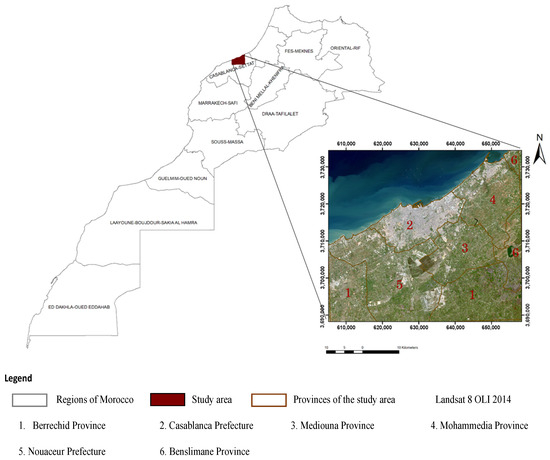
Figure 1.
Study area.
The main reason we chose this zone is due to the strong urbanization and expansion of residential and industrial areas in the city of Casablanca and its outskirts, including Bouskoura, Dar Bouaazza and Mohammadia. Indeed, agricultural land in this area is under heavy pressure, hence the importance of urban and peri-urban agriculture which can help offset the decline in agricultural land by using urban spaces such as rooftops, balconies and public spaces to grow food.
2.2. Data Analysis
2.2.1. Satellite Image
The data used were collected from United States Geological Survey (USGS) website, specifically the multi-temporal “LANDSAT” satellite images with a resolution of 30 m, acquired in time series ranging from 1991 to 2024; see Table 1.

Table 1.
Characteristics of the satellite images.
To reduce the impact of seasonal variations, the images were obtained within the same season, adhering to criteria for atmospheric and phenological similarity [9]).
2.2.2. HCP Data and Restitution
Demographic datasets for the years 1994 and 2014 were provided by the High Commission for Planning (HCP) in Morocco and contain a variety of information, including data on population demographics, agricultural statistics, and economic indicators [15].
Restitution plans for the city of Casablanca for the year 2013 were also acquired, along with data from the general population and housing census, to calculate the SDG 11.3.1 urban development indicator.
2.3. Image Classification
After processing the images according to the study area, we proceed to image classification. These images have been categorized into five classes, namely: (1) water bodies, (2) forest, (3) barren land, (4) artificial areas, and (5) arable land.
The classification of the images was carried out according several methods in particular maximum likelihood, SVM, and neural networks. The goal was to ultimately determine the most suitable method for the study.
2.4. Analyze the Urban Sustainable Development Indicator SDG 11.3.1
The UN-defined urban sustainability development indicator (SDG 11.3.1) targets the monitoring of urban development by comparing the rate of urban land consumption to the rate of the urban population growth during the same period [16]. The value of SDG indicator 11.3.1 is calculated using the Land Consumption Rate (LCR) and the Population Growth Rate (PGR) according to the methodology established by the United Nations [11].
SDG 11.3.1 is obtained by calculating the ratio between the LCR and the PGR [11].
where Ln is the natural logarithm, Urb [t] is the built-up area during the initial year, and Urb [t + ∆t] is the built-up area in a future year. Similarly, Pop [t] is the total population in the initial year for each urban area, and Pop [t + ∆t] is the total population in the same urban area in the future year; ∆t is the time interval between the two measurements [11].
3. Results
3.1. Classification Result
The choice of classifiers in this study is supported by previous research highlighting the superior performance of Support Vector Machines (SVM) and Artificial Neural Networks (ANN) over the traditional Maximum Likelihood Classifier (MLC). Shivakumar and Rajashekararadhya (2018) achieved an accuracy of 83.7% using MLC on Landsat 8 imagery and recommended further comparisons with more advanced classifiers [17]. Following this, Susan John and Varghese (2022) compared MLC and SVM using Sentinel-2 data in India and found that SVM significantly outperformed MLC, achieving an average overall accuracy of 91.78% and a Kappa coefficient of 0.89, compared to 87.07% and 0.83, respectively, for MLC [18]. Dixon and Candade (2008) [10] confirmed the superior performance of ANN and SVM over MLC. However, they noted that ANN requires a large number of training samples as dimensionality increases, whereas SVM remains effective even with limited samples, due to its ability to maximize class separation using support vectors.
For the vector support algorithm (SVM) application, the RBF kernel type has been used and the cost parameter was fixed to one which is similar to the parameter applied by scikit-learn documentation.
The maximum likelihood algorithm did not yield better results compared to the SVM, as already confirmed in the study [18].
Regarding the neural networks, after conducting multiple trials by adjusting parameters such as the learning rate, number of iterations, and RMS, the trial that led to the best result was the one with an RMS of 0.05, a learning rate of 0.2 and 1000 iterations.
Based on the results obtained from the different classifications and considering the accuracy achieved through neural network classification, we will adopt the latter for all satellite images; see Table 2.
Table 2.
Results of classifications.
Taking into account the results in Table 3, we can conclude that the classification results of all images from 1991, 2005, 2014, and 2024 using the neural network are acceptable. The land use map generated using the neural net classifier is shown in Figure 2; see Figure 2.
Table 3.
Metrics for evaluating neural network classification.
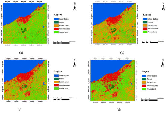
Figure 2.
Land use map of Casablanca city and its outskirts for 1991, 2005, 2014 and 2024 (a–d).
In accordance with the classification results, we will proceed to quantify the land use change between 1991 and 2024. Subsequently, we will evaluate the SDG 11.3.1 urban development indicator for this area to better understand the dynamics of urban expansion [11].
3.2. Quantification of Land Use CHANGE Between 1991 and 2024
Satellite image classification has played a pivotal role in producing a detailed mapping that captures the spatio-temporal evolution of the Casablanca city and its surrounding areas over a period of 32 years, from 1991 to 2024.
The graph represents the evolution of different land use classes between 1991 and 2024. Firstly, it highlights a significant growth in the artificial areas or urbanized land class, encompassing 45% of the entire study zone’s area. This significant increase can be attributed to the growing urbanization; see Figure 3.
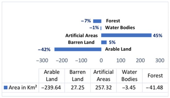
Figure 3.
Quantification of land use change between 1991 and 2024.
3.3. Land Use Change Mapping 1991–2024
This map Figure 4 provides a clear and explicit visualization of the transformation of unbuilt land or natural land into artificial areas over time. The conversion of unbuilt land into artificial areas is primarily concentrated on the periphery of Casablanca city, including the Nouaceur prefecture, Mediouna province, and Mohammadia.
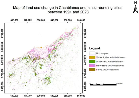
Figure 4.
Map of land use transition in Casablanca and its surrounding areas between 1991 and 2024.
The map illustrates the evolution of arable land into artificial surfaces in the city of Casablanca and its surrounding areas between 1991 and 2024. It shows that 12% of the land previously dedicated to agriculture has been converted into urban or artificial areas (Figure 5), and 19% of the land lacking vegetation or plant cover has undergone a transformation into urban or artificial areas during this period. Future work will aim to identify the types of crops affected and evaluate the potential consequences on local and regional food security.
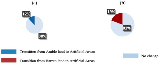
Figure 5.
Rate of transition, from arable land to artificial areas (a) and from barren land to artificial areas (b) from 1991 to 2024.
3.4. Analyze the Urban Sustainable Development Indicator SDG 11.3.1 in Casablanca and Its Surrounding Cities
3.4.1. SDG 11.3.1 Indicator by Province Between 1994 and 2024
The analysis of SDG indicator 11.3.1, which is calculated as the ratio of land consumption rate (LCR) to population growth rate (PGR), shows that in the province of Nouaceur, the indicator value is less than 1 (Figure 6). This implies that between 1994 and 2024, the rate of urban land expansion was slower than the rate of population growth (LCR < PGR), reflecting a relatively efficient urban development pattern.
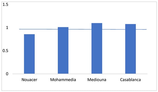
Figure 6.
SDG 11.3.1 indicator by province between 1994 and 2024.
In contrast, for the other provinces where the indicator exceeds 1, the land consumption rate outpaces population growth (LCR > PGR). This suggests potential urban sprawl or inefficient land use practices. Such discrepancies across provinces call for a more in-depth investigation into local urban policies, population distribution patterns, and land management strategies to understand the driving forces behind these trends.
3.4.2. SDG 11.3.1 Indicator by Municipality Between 1994 and 2014
The indicator values for the municipalities of Casablanca and the surrounding areas are presented in the graph below and are classified to facilitate comparison between them. Out of a total of 19 municipalities, only 7 have an indicator greater than 1.0, namely the municipalities of Nouaceur, Mohammadia etc. This indicates that urban land consumption in these municipalities is occurring at a faster rate than population growth; see Figure 7.
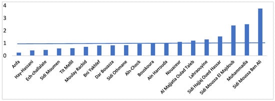
Figure 7.
SDG 11.3.1 Indicator value in the municipalities of Casablanca province and its peripheries (1994–2024).
To better contextualize the results of SDG indicator 11.3.1, several studies have been conducted in other regions of the world. For example, Mudau, et al. (2020) [16] assessed this indicator in four South African cities using Landsat satellite imagery and census data from 1996, 2001, and 2011. Their findings revealed varying urban dynamics, with an increase in land consumption per capita between 1996 and 2001, followed by a decrease between 2001 and 2011. Similarly, a study by Bounoua et al. (2023) [11] examined urban sustainability in five major Algerian urban areas using GAIA data and census records from 2008 and 2018. The results highlighted significant disparities: while the Oran region showed a relatively balanced relationship between land use and population growth, areas like Algiers and Annaba presented inconsistencies, with urban expansion not always aligned with demographic trends. These findings underscore the value of SDG 11.3.1 in analyzing urbanization patterns across diverse contexts.
3.5. Urban Agriculture as an Effective Green Infrastructure for Enhancing Urban and Environmental Resources
Urban and Peri-Urban Agriculture Concept
According to other international institution FAO (2023), urban and peri-urban agriculture (UPA) refers to the set of practices that produce food and other outcomes through agricultural production and related processes (processing, distribution, marketing, recycling, etc.), which take place on land and other spaces within cities and surrounding areas. Urban and peri-urban agriculture (UPA) is recognized as a sustainable solution to a number of socio-economic and environmental issues [14].
- Community or allotment gardens often represent small-scale, highly patchy and qualitatively rich (vegetatively complex and species rich) semi-natural ecosystems that are usually located in urban or semi-urban areas for food production.
- Private gardens are primarily located in suburban areas and may be the most prevalent form of urban agriculture in cities.
- Rooftop gardens or green roofs are any vegetation established on the roof of a building and can be used to improve insulation, create local habitat, provide decorative amenities, and cultivate food plants [13].
4. Discussion and Conclusions
Given that the city of Casablanca and its outskirts are affected by the phenomenon of urbanization, the detection of spatio-temporal land change remains a crucial step in understanding the trend of land transformation within the city. Over the years, Casablanca has witnessed rapid urban growth and an expansion of its urban area into the surrounding rural areas. This expansion of urban areas has been driven by factors such as population increase, economic development, and the allure of economic opportunities provided by the city.
To do this, we have established a methodology for processing satellite images, ranging from image acquisition, preprocessing, and evaluation of a set of classification methods, to the selection of the neural network classification method that leads to the most accurate result. This will enable us to create land use maps for all dates, in order to subsequently quantify changes in the classes of built and non-built-up areas. However, to better understand this change, we referred to the sustainable urban development indicator SDG 11.3.1 to assess urban sprawl.
Based on the obtained results, it can be affirmed that the prefecture of Casablanca, the province of Mohammadia, and that of Mediouna have recognized a faster consumption of land than population growth in recent years. This could lead to issues such as excessive urban sprawl, fragmentation of agricultural land, environmental degradation, and pressure on natural resources. To address these issues, we propose a conceptual framework to integrate urban and peri-urban agriculture for improved food security, sustainability promotion, and job creation.
Indeed, it is often difficult, if not impossible, to completely halt urban sprawl due to population growth. However, it is crucial to consider alternative approaches to incorporate urban and peri-urban agriculture as a response to the challenges mentioned earlier. The approach we propose is as follows:
- -
- Prior to any construction, we will assess the soil type of the specific plot, whether it is loamy, sandy, or clayey [19].
- -
- We will import and preserve the soil of the plot.
- -
- We will select open sites within urban and peri-urban areas, such as urban green spaces like parks and public gardens, which can be repurposed to accommodate community gardens or vegetable cultivation. Building rooftops can also be transformed into agricultural spaces.
- -
- Lastly, we will determine the type of crops to be cultivated based on several previously mentioned factors, such as wind and sun exposure.
Author Contributions
Conceptualization, A.M. and H.B.; methodology, A.M.; software, A.M.; validation, H.B., I.S. and K.A.E.K.; writing—original draft preparation, A.M.; supervision, H.B., I.S. and K.A.E.K. All authors have read and agreed to the published version of the manuscript.
Funding
This research received no external funding.
Institutional Review Board Statement
Not applicable.
Informed Consent Statement
Not applicable.
Data Availability Statement
The data supporting the findings of this study are available from the corresponding author upon reasonable request. The datasets are stored in a private Google Drive folder and can be shared upon request for academic and research purposes.
Acknowledgments
Special thanks go to the colleagues and staff who contributed indirectly to the success of this work through their valuable assistance and collaboration.
Conflicts of Interest
The authors declare no conflicts of interest.
References
- World Bank 2020. Morocco. Available online: https://data.worldbank.org/country/morocco (accessed on 1 May 2025).
- El Asslouj, J.; Kholtei, S.; El Amrani-Paaza, N.; Hilali, A. Impact des activités anthropiques sur la qualité des eaux souterraines de la communauté Mzamza (Chaouia, Maroc)**. Rev. Sci. L’eau 2007, 20, 309–321. [Google Scholar] [CrossRef][Green Version]
- Bahi, H.; Radoine, H.; Mastouri, H. Spatio-temporal Evaluation of Urban Thermal Environment Using Smart Spatial Data. In Proceedings of the 2019 7th International Renewable and Sustainable Energy Conference (IRSEC), Agadir, Morocco, 27–30 November 2019; IEEE: New York, NY, USA, 2019; pp. 1–6. [Google Scholar] [CrossRef]
- Bahi, H.; Radoine, H.; Mastouri, H. Urban Heat Island: State of the Art. In Proceedings of the 2019 7th International Renewable and Sustainable Energy Conference (IRSEC), Agadir, Morocco, 27–30 November 2019; IEEE: New York, NY, USA, 2019; pp. 1–7. [Google Scholar] [CrossRef]
- Barakat, A.; Ouargaf, Z.; Khellouk, R.; El Jazouli, A.; Touhami, F. Land Use/Land Cover Change and Environmental Impact Assessment in Béni-Mellal District (Morocco) Using Remote Sensing and GIS. Earth Syst. Environ. 2019, 3, 113–125. [Google Scholar] [CrossRef]
- Bahi, H.; Rhinane, H.; Bensalmia, A.; Fehrenbach, U.; Scherer, D. Effects of Urbanization and Seasonal Cycle on the Surface Urban Heat Island Patterns in the Coastal Growing Cities: A Case Study of Casablanca, Morocco. Remote Sens. 2016, 8, 829. [Google Scholar] [CrossRef]
- Tahiri, M.; Mohsine, I.; Bouramtane, T.; Bahi, H.; Malah, A.; Sabri, A.; Kacimi, I. Spatio-Temporal Analysis of the Remote Sensing Ecological Index—A Case Study of the Favorable Agro-Ecological Zone in Northwest Morocco. Ecol. Eng. Environ. Technol. 2023, 7, 61–70. [Google Scholar] [CrossRef]
- Bren D’Amour, C.; Reitsma, F.; Baiocchi, G.; Barthel, S.; Güneralp, B.; Erb, K.-H.; Haberl, H.; Creutzig, F.; Seto, K.C. Future Urban Land Expansion and Implications for Global Croplands. Proc. Natl. Acad. Sci. USA 2017, 114, 8939–8944. [Google Scholar] [CrossRef] [PubMed]
- Dechaicha, A.; Alkama, D. Suivi et quantification de l’urbanisation incontrôlée: Une approche basée sur l’analyse multitemporelle des images satellitaires LANDSAT. Cas de la ville de Bou-Saada (Algérie). Rev. Française Photogrammétrie Télédétection 2021, 223, 159–172. [Google Scholar] [CrossRef]
- Dixon, B.; Candade, N. Multispectral Landuse Classification Using Neural Networks and Support Vector Machines. Int. J. Remote Sens. 2008, 29, 1185–1206. [Google Scholar] [CrossRef]
- Bounoua, L.; Bachir, N.; Souidi, H.; Bahi, H.; Lagmiri, S.; Khebiza, M.Y.; Nigro, J.; Thome, K. Sustainable Development in Algeria’s Urban Areas: Population Growth and Land Consumption. Urban Sci. 2023, 7, 29. [Google Scholar] [CrossRef]
- Berger, M.; Frust, J.-P.; Plet, F.; Robic, M.-C. Rurbanisation et analyse des espaces ruraux péri-urbains. L’espace Géographique 1980, 9, 303–313. [Google Scholar] [CrossRef]
- Pearson, L.J.; Pearson, L.; Pearson, C.J. Sustainable Urban Agriculture: Stocktake and Opportunities. Int. J. Agric. Sustain. 2010, 8, 7–19. [Google Scholar] [CrossRef]
- Rejeb, H. Les Enjeux de L’agriculture Urbaine et Périurbaine en Tunisie; Lettres de Veilles CIHEAM: Montpellier, France, 2011. [Google Scholar]
- Recensement population (RGPH) 2014―HCP. Available online: https://www.hcp.ma/Recensement-population-RGPH-2014_a2941.html (accessed on 1 May 2025).
- Mudau, N.; Mwaniki, D.; Tsoeleng, L.; Mashalane, M.; Beguy, D.; Ndugwa, R. Assessment of SDG Indicator 11.3.1 and Urban Growth Trends Major and Small Cities in South Africa. Sustainability 2020, 12, 7063. [Google Scholar] [CrossRef]
- Shivakumar, B.R.; Rajashekararadhya, S.V. Investigation on Land Cover Mapping Capability of Maximum Likelihood Classifier. Procedia Comput. Sci. 2018, 143, 579–586. [Google Scholar] [CrossRef]
- John, S.; Varghese, A.O. Analysis of Support Vector Machine and Maximum Likelihood Classifiers in Land Cover Classification Using Sentinel-2 Images. Proc. Indian Natl. Sci. Acad. 2022, 88, 213–227. [Google Scholar] [CrossRef]
- Benazzouz, I.; Talbi, M.; Saber, N. Etat Environnemental Des Sols De La Region De Casablanca. Eur. Sci. J. 2020, 16, 90. [Google Scholar] [CrossRef]


Disclaimer/Publisher’s Note: The statements, opinions and data contained in all publications are solely those of the individual author(s) and contributor(s) and not of MDPI and/or the editor(s). MDPI and/or the editor(s) disclaim responsibility for any injury to people or property resulting from any ideas, methods, instructions or products referred to in the content. |
© 2025 by the authors. Licensee MDPI, Basel, Switzerland. This article is an open access article distributed under the terms and conditions of the Creative Commons Attribution (CC BY) license (https://creativecommons.org/licenses/by/4.0/).