Abstract
This study aims to explore how historical attractions in old urban areas effectively contribute to tourism development. In particular, the accessibility and convenience of transport are analyzed using Spatial Syntax. Previous collaborative projects with local community colleges were assessed to obtain recognized spatial boundaries of old districts. The historic buildings and their points of interest were determined by the Hsinchu City Council. Modern cities’ grid patterns and straight roads connect various scenic spots. Using the spots, spatial syntactic analyses were conducted in this study. The impact of spatial features on the assessment was found indirect and dependent on the road network of the Old Town. A social responsibility program was also developed to investigate the rise and fall of cities in the development process.
1. Introduction
Space syntax has been used in the education of architecture and urban analysis [1]. Basic principles lie in the internal logic between space and society and the use of space related to the environment. Through shared participation, similarities and differences in the environment and possible relationships in the design process can be researched.
Through several projects, the points of interest (POIs) were determined in this study. A point of interest is a specific location that people find helpful or interesting. Regarding the POI as a starting point, historical architecture can be studied [2]. People and cities need historical inheritance [3], and traditional structures need to be preserved. By constructing universal principles based on Space Syntax, environmental problems can be solved [4]. In this study, we proposed a game-like navigation scheme to understand how a city attracts visitors. The result provides the basis for the development of teaching content.
2. Research Background
Urban attractions were assessed using Spatial Syntax. In general, POIs are concentrated in different but close areas. Tourist agencies introduce sightseeing spots but seldom recommend a particular thematic tour.
Hsinchu Community University (HCU) has collaborated with the Department of Architecture and Urban Planning (DAUP) since early 2023. HCU has developed an outdoor game. The content was designed for (1) identifying scenic spots in the old districts that are worth visiting based on the memories of the elders in the community; (2) designing a treasure hunt game on mobile phones based on identified scenic spots; and (3) assisting the elders in using and testing the real-life scenarios.
Five community elders participated in this project, each recommending at least three to four locations or objects of local interest. The total number of local attractions was 18. For implementation, the game summarized the local attractions in the old district. The target users of this game were tourists, especially to help the elderly play the game. It was essential to consider the appropriateness of the game for expected users with attractive content.
2.1. APP Development and Application
Artificial intelligence (AI) was used in the game APP development. Existing applications or free online services such as Supergeo’s mobile tour book system were used along with CANVA’s AI presentation, LINE’s digital sticker design, and QR code design. The game corresponded to the project of the community. The students of HSU participated in the outreach service.
2.2. POI
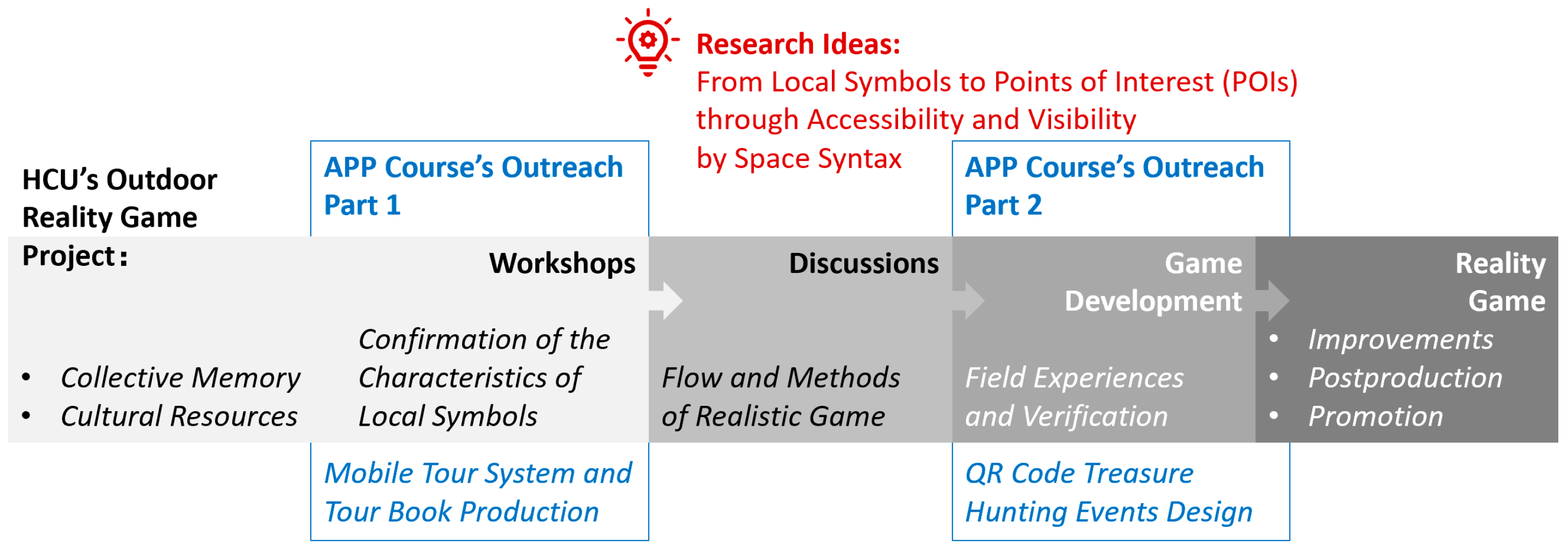
The banner in Figure 1 presents the key stages of outdoor reality game development. The participants were grouped into two groups. The first group assisted the elders in identifying the number and location of local attractions. The other group moved around the old city to find local attractions.
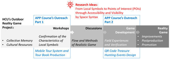
Figure 1.
Scope of outreach activities for architecture student interventions. The blue font indicates the original learning content of the APP course. Red fonts indicate the conceptual stage of this study.
The participants needed to understand the game design process and methodology, and their results were integrated into the game. Local attractions and urban spaces recommended by the elderly were included, too. The existing road network and the environment were assessed for convenient sightseeing in terms of visualization and accessibility [5]. In this study, the accessibility and visibility of the streets in Hsinchu Old Town were defined by connecting POIs using Space Syntax.
3. Methods
The game enables the player to treasure hunt to guide them to destinations. It is a pedestrian navigation system guided by POIs and visibility [6]. When deciding on the next step, the more recognized attractions are used. The attractions show the historical progress that is learned by players (Figure 2).
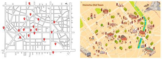
Figure 2.
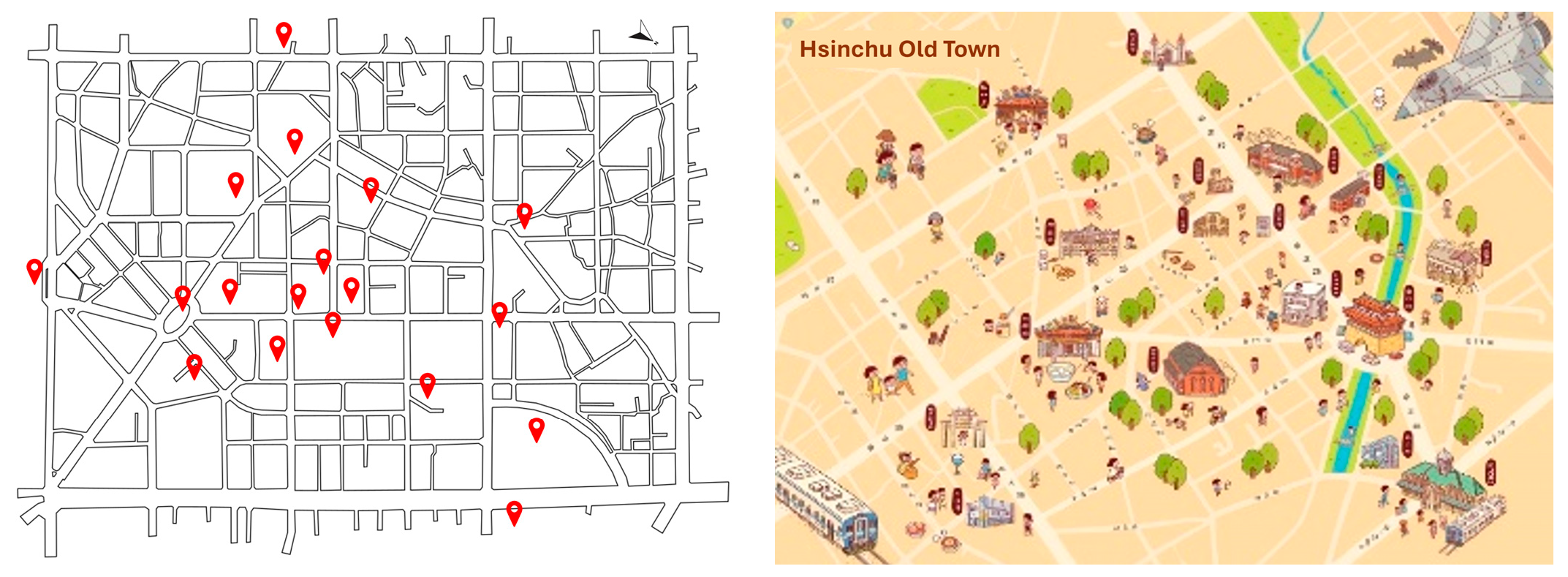
Hsinchu Old Town Attraction maps: (left image) corresponding locations of the old street network and points of interest (red location icons); (right image) old town walking map planned by the city government.
In Figure 2, 18 tourist attractions (red location icons) are presented. They are located within walking distance in the central area of the old town to find the correspondence between Space Syntax analyses and direct field observations. The accessibility of walking was evaluated based on both visibility and activity levels.
Space Syntax is a set of theories and techniques used to analyze and describe patterns of human behavior in buildings and urban spaces [7]. It represents the spatial configuration of urban and architectural structures and their impact on behavioral patterns. DepthmapX (ver 0.8.0) is software to analyze urban and architectural spaces based on the principles of space syntax [8]. In this study, angular segment analyses of metric radii at a localized level within the old town center were carried out to investigate the movement potential of pedestrians using Space Syntax and DepthmapX ver 0.8.0.
4. Results and Discussion
4.1. Old Town
The old city district of Hsinchu City is located in the north part of Hsinchu City Centre. It covers an area of about 120 ha and spans the northern and eastern districts. In 1827, the Qing court set up the Drum Tower and the government office with the City God’s Temple as the center. The main roads were planned in the traditional Chinese style of crosses, connecting the four city gates of the east, west, north, and south, and the masonry city wall was built. During the Japanese colonial period, the original four gates and their fences were demolished, leaving only the East Gate, which was reconfigured in the form of a checkerboard, and part of the street pattern of the Qing Dynasty was used [9].
Over the past 40 years, Hsinchu has been urbanized from the city center to the outlying villages. In today’s development, the central city district still has old houses, overloaded infrastructure, and narrow roads [9]. At the locations of the 18 POIs, 13 are on the old town street (Figure 2). Therefore, a walkable environment is crucial in the dense road network.
4.2. Visibility Graph Analysis (VGA)
VGA is a space syntax method that measures the socio-spatial properties of the built environment by representing floor plans as grids. This method represents a visual accessibility to allow pedestrians to use the visibility map and select the next destinations [7]. VGA is used to explain the visibility of space based on urban form, clustering coefficient, global integration measurement, and local control measurement.
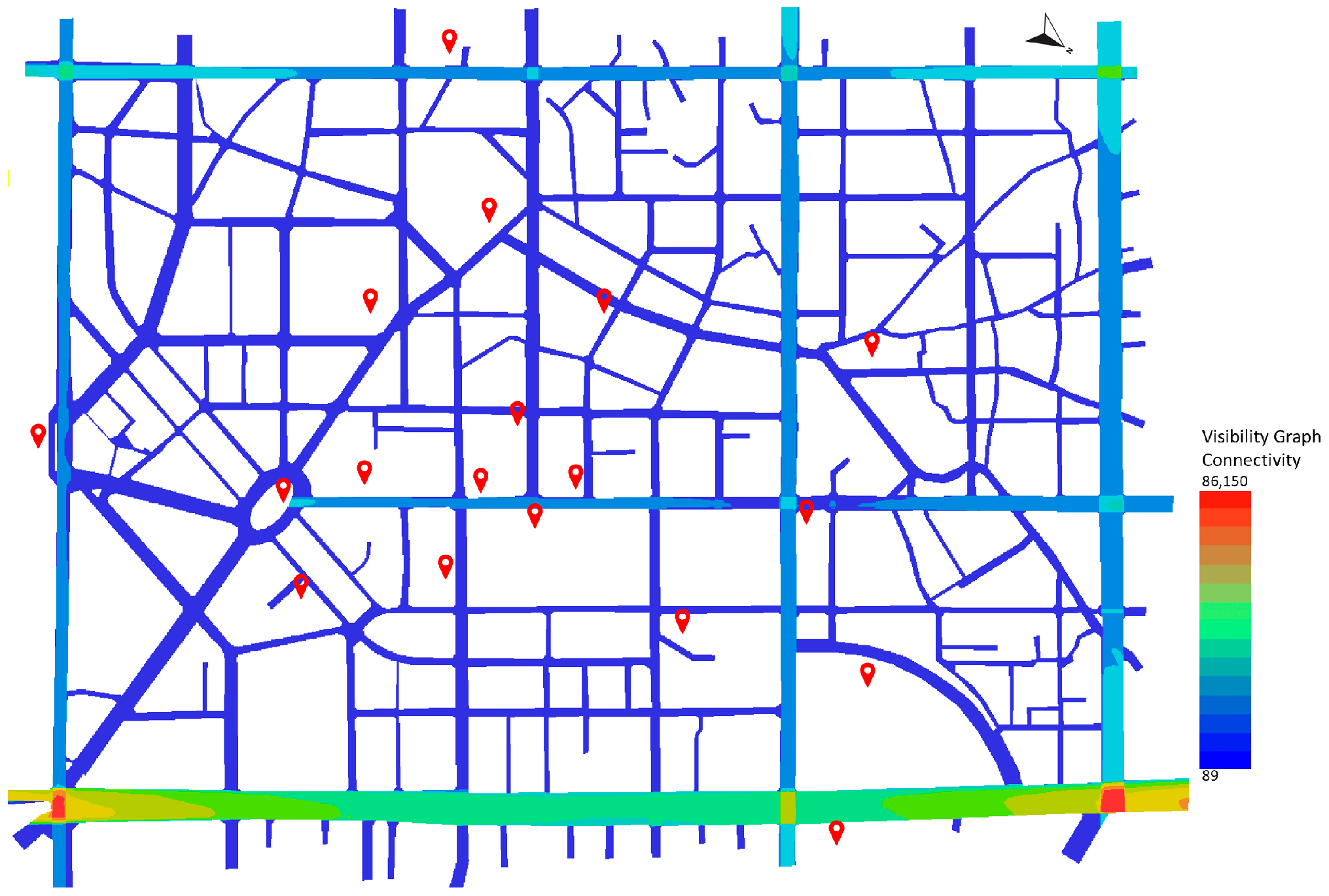
The index of visibility relationships between spaces and the built environment was constructed. The locations of the attractions were visible from all angles. According to the simulation result (Figure 3), the visibility of the old city core area and the outer zone was similar. Most blocks were presented in blue, which indicates low visibility, indicating that POIs were not easily found by visitors [10,11]. Dongda Road is the only street visible to visitors.
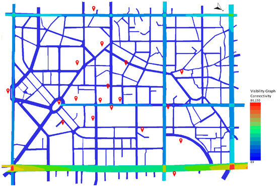
Figure 3.
Visibility of Old Town area. The red location icons are marked as points of interest.
The walkability of the surrounding road system in the central area of Hsinchu’s old city and its periphery was simulated (Table 1). The results revealed low connectivity, local fragmentation, and axial analysis choices. These narrow streets affected the connectivity of the old city’s street network, making the area less convenient for pedestrians.

Table 1.
Attribute a summary of the measurement results of the visibility graph analysis (VGA).
4.3. Axial Line Analysis
The recognition map was converted into an axial format before being analyzed using Space Syntax. Axial analysis was conducted to examine interconnectivity in course-degree motion [8]. The axes were adjusted to constitute the movement linearly on the urban street and road network. The axis was used as the fundamental element, representing the movement and form path in the built environment. It represents the total length of streets in a network connected to other streets [12]. Connectivity was assessed to estimate street accessibility in an urban environment. Axial connectivity was used to measure the level of direct accessibility from connected streets. In contrast, axial integration was used to measure the extent and total number of directional changes in potential movement.
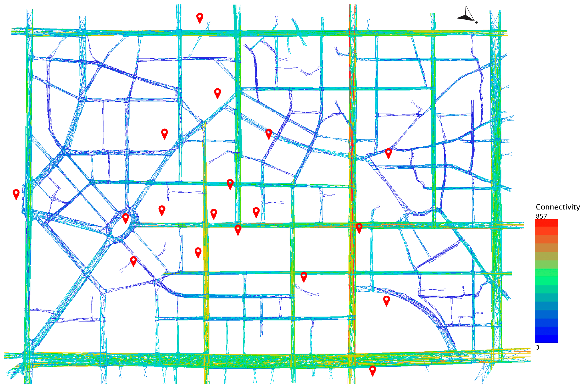
Figure 4 shows that the street network in the central area of the old city is inconvenient because the streets or alleys are limited in size. According to this analysis, while the street network’s highest connectivity index was 857, its lowest connectivity index was 3. However, roads with higher indexes belonged to the peripheral, modern grid road network. The nearby attractions are contemporary and are not ancient buildings with historical value. Most ancient buildings are located in low connectivity index areas.
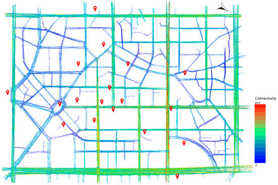
Figure 4.
Connectivity measures the amount of space directly connected to the original space in Old Town area (all-line map). The red location icons are marked as points of interest.
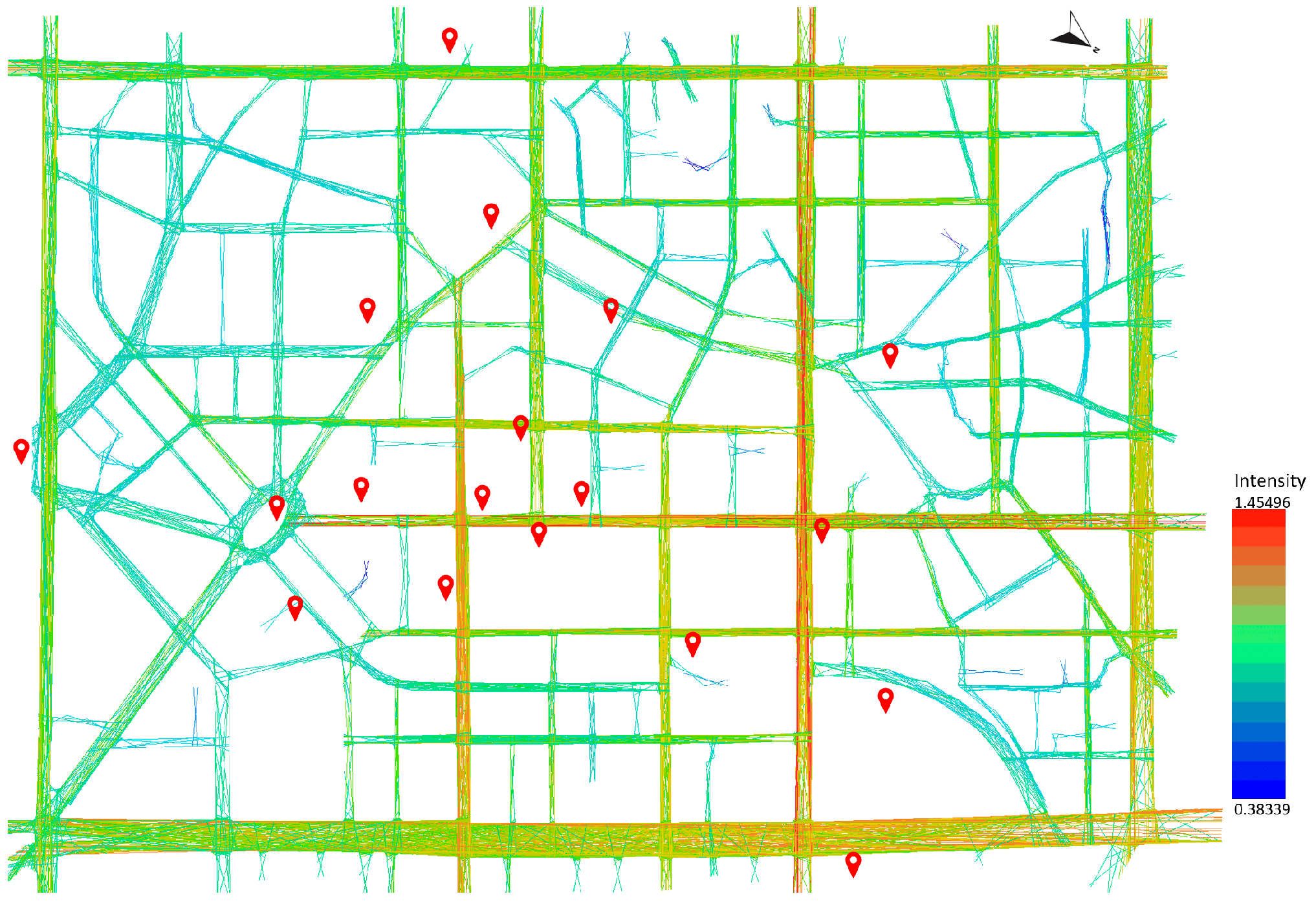
The axial line analysis result indicated the most extended and minor movement path and steering direction modification of the line of sight through indicator attributes. The connectivity presents the number of spaces directly connected to the original space. Streets and buildings are two relatively separate systems. Streets are public spaces, and there are no status restrictions on the use of streets in modern cities. In public spaces, streets are open to everyone equally [13]. We calculated the integration value of a single axis based on the axis diagram. The value was applied to the spatial boundaries on both sides. Different values were used for different spatial interfaces if there was an intersection with multiple axes [14] (Figure 5).
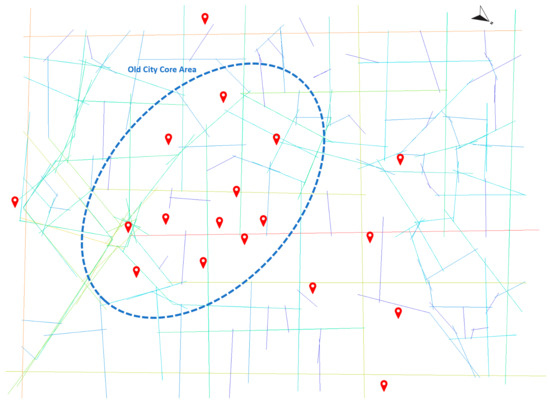
Figure 5.
Old Town connectivity (fewest-line map). The red location icons are marked as points of interest.
Figure 5 shows the axis diagram’s values, such as the degree of integration and the characteristics of the building interface. As modern architecture and urban planning methods emphasize the functions of buildings, the functionality of land use is also stressed. The public space is a space for travel. The axis diagram expresses the spatial status of the travel function. Nine POIs were closest to the street with the highest connectivity value (the index was 23). 11 POIs were located in the central area of the old city.
Building districts are different from streets. Buildings must have internal and external spaces. The isolated space is not in use, and the status of the space is different for visitors [15]. The axis diagram shows buildings, street networks, and private, isolated, and public open spaces. It also summarizes the interface between public and private spaces in the city.
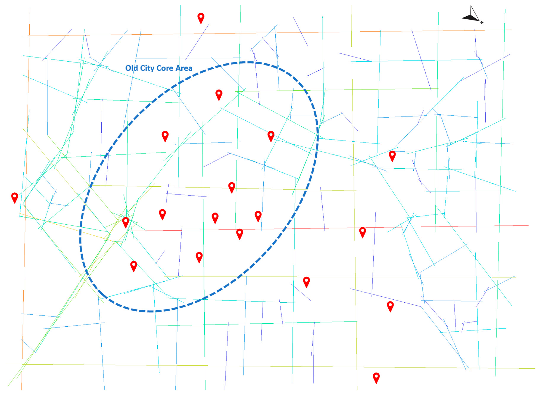
The state of urban space is not static. It is changed accordingly based on the functional requirements of people and society. It is beneficial if the space is renovated. The city is a complex system whose spatial structure constantly changes [3]. The functions a specific place serves are determined by the requirements. As the requirements change, the state of architectural space must be redefined through functional debugging [7,8]. Space Syntax was used to measure the spatial location based on distance. As many locations are close to each other, the distance is asymmetric, and the entropy is low. The more uniform the distribution, the higher the entropy. Significant topological differences in the road network are presented in Figure 6. POIs have low entropy values, approximately below 1.86.
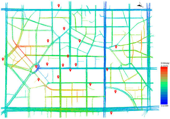
Figure 6.
The entropy in depthmapX measures the distribution of spatial locations based on the depth of the distance space rather than the depth itself. If the POI distribution is more uniform, the entropy is higher. The red location icons are marked as points of interest.
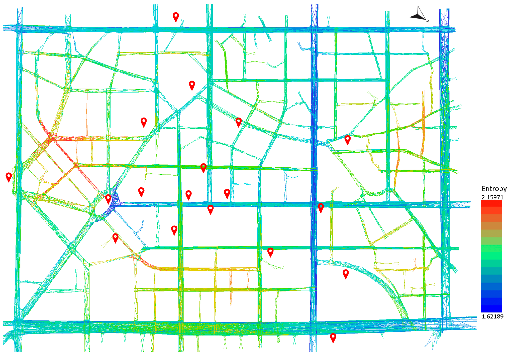
In addition to entropy, the relative asymmetry of the spatial network was measured by calculating the change rate of intensity. Mobility efficiency was calculated, considering the distance people travel within the network. In modern times, the number of POIs has increased, reaching at least 15 due to the influence of the new grid road network. Using the road network of the old city (Figure 7), the modern grid pattern and the demolished old city walls were found to have high intensity.
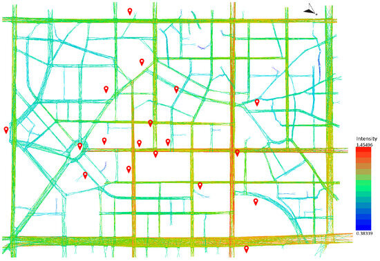
Figure 7.
This is another way to normalize the total depth. The distance between POIs is average in the old city.
The axis diagram summarizes the function of travel that is related to spatial structure. The axis diagram was used to determine if the roads in the city were accessible. A self-enclosed space was excluded from the analysis. Table 2 presents the result of the axis analysis for all POIs.

Table 2.
Result of measurement results of the axial line analysis.
5. Conclusions
Visibility plays an important role in behavioral patterns and components in urban environments. When visibility in urban spaces is high, proactive behavioral patterns are found. POIs near the grid road network have high visibility, guiding visitors to behave actively. For POIs on narrow streets with low visibility, visitors passively behave. Most active behaviors are related to higher visibility. Therefore, it is crucial to design urban spaces according to visibility and visitors’ preferences.
In today’s urban spaces, behavioral patterns change the city’s planning. The behavioral preferences for buildings and spaces have changed [9]. As monumental buildings in historic locations have survived, connectivity and integrity must be maintained. The simulation result in this study showed the spatial and cognitive features with which visitors interact according to their behavioral patterns [16]. “Reality games” or “tour planning” can be created using Space Syntax to assess the proximity associated with POIs. Additionally, comparisons of spaces and buildings can be enabled. Space Syntax needs can also be used for street management [17] and street selection analysis.
Funding
This research received no external funding.
Institutional Review Board Statement
Not applicable.
Informed Consent Statement
Not applicable.
Data Availability Statement
Data are available upon request.
Acknowledgments
Special thanks to the APP participants who participated in this outreach service. They stayed to continue their studies and recorded their relevant learning experiences. The author was responsible for contacting external student outreach activities.
Conflicts of Interest
The author declares no conflicts of interest.
References
- Mason, T.; Li, C.; Song, S.; Yang, Y. Going Back to Basics: The challenges and limitations of teaching Space Syntax through short course programs within mainland China. In Proceedings of the 13th Space Syntax Symposium, Bergen, Norway, 20–24 June 2022. [Google Scholar]
- Natapov, A.; Cohen, A.; Dalyot, S. Urban planning and design with points of interest and visual perception. Environ. Plan. B Urban Anal. City Sci. 2024, 51, 641–655. [Google Scholar] [CrossRef]
- Portmann, E. Rezension “Smart Cities: Big Data, Civic Hackers, and the Quest for a New Utopia”; Springer: Berlin/Heidelberg, Germany, 2015. [Google Scholar] [CrossRef]
- Rostami, A.; Fatehi, H.B. Urban square design with pedestrian approach based on space syntax method (Case study: Aysan project area of Tabriz). Int. J. Health Sci. 2022, 6 (Suppl. S7), 48366–48384. [Google Scholar] [CrossRef]
- Luo, Y.; Lin, Z. Spatial Accessibility Analysis and Optimization Simulation of Urban Riverfront Space Based on Space Syntax and POIs: A Case Study of Songxi County, China. Sustainability 2023, 15, 14929. [Google Scholar] [CrossRef]
- Li, Y.; Barbieri, N.; Quercia, D. Applying space syntax to online mapping tools. In Proceedings of the Tenth ACM International Conference on Web Search and Data Mining, Cambridge, UK, 6–10 February 2017; pp. 273–282. [Google Scholar] [CrossRef]
- Hillier, B. Space Is the Machine: A Configurational Theory of Architecture; Space Syntax: London, UK, 2007. [Google Scholar]
- Thaler, U. Space syntax methodology. In Archaeological Spatial Analysis; Routledge: London, UK, 2020; pp. 296–312. [Google Scholar]
- Tseng, C.Y.; Chen, H.J. Historical Urban Area’s Cultural Governance: On the Regeneration Movement of Historical Urban Area of Hsinchu City. Stud. Int. Cult. 2018, 14, 37–62. [Google Scholar]
- Erol, A.; Çanakçıoğlu, N.G. A study on the use of urban spaces in historical environments through behaviour mapping and space syntax: The case of Mudanya. In Proceedings of the 13th International Space Syntax Symposium, Bergen, Norway, 20–24 June 2022. [Google Scholar]
- Xu, Y.; Rollo, J.; Esteban, Y. Evaluating experiential qualities of historical streets in Nanxun Canal Town through a space syntax approach. Buildings 2021, 11, 544. [Google Scholar] [CrossRef]
- Ledewitz, S. The Social Logic of Space. J. Archit. Plan. Res. 1991, 8, 260–266. [Google Scholar]
- Zhang, J.; Shi, L. Spatial Intersection Analysis Based on the Choice of Streets, the Functionality Mixing Degree of Land Use and the Green Visibility Rate by Street Views—Taking the City Center in Shanghai as the Research Area. J. Civ. Eng. Urban Plan. 2023, 5, 52–58. [Google Scholar] [CrossRef]
- Asriana, N.; Koerniawan, M.D.; Tambunan, L.; Paramita, B. The Effects Street-Network Configuration in Modelling Walkability Through Space Syntax. DIMENSI J. Archit. Built Environ. 2023, 50, 13–20. [Google Scholar] [CrossRef]
- Yılmaz, T.; Öter, B. Application of the Space Syntax method in accessibility studies, Antalya city case. Int. J. Agric. Environ. Food Sci. 2021, 5, 74–77. [Google Scholar] [CrossRef]
- Eldiasty, A.; Samra, M.; Eleishi, A. Space syntax as an evaluative and predictive tool to explore urbanity levels in New Damietta City. JES J. Eng. Sci. 2020, 48, 910–926. [Google Scholar] [CrossRef]
- Dawes, M.; Ostwald, M.J. Precise locations in space: An alternative approach to space syntax analysis using intersection points. Archit. Res. 2013, 3, 1–11. [Google Scholar] [CrossRef]
Disclaimer/Publisher’s Note: The statements, opinions and data contained in all publications are solely those of the individual author(s) and contributor(s) and not of MDPI and/or the editor(s). MDPI and/or the editor(s) disclaim responsibility for any injury to people or property resulting from any ideas, methods, instructions or products referred to in the content. |
© 2025 by the author. Licensee MDPI, Basel, Switzerland. This article is an open access article distributed under the terms and conditions of the Creative Commons Attribution (CC BY) license (https://creativecommons.org/licenses/by/4.0/).

