Proceeding Paper

Application of a Risk Management System of Road Networks Exposed to Volcanic Hazards †

1
Department of Construction Engineering and Management, School of Engineering, Pontificia Universidad Católica de Chile, Santiago 7820436, Chile
2
Research Center for Integrated Disaster Risk Management (CIGIDEN), ANID/FONDAP/1522A0005, Santiago 7820436, Chile
3
Latin American Center for Economic and Social Policies (CLAPES UC), Pontificia Universidad Católica de Chile, Santiago 8331010, Chile
4
Department of Civil Engineering, Engineering Faculty, University of Concepción, Concepción 4070409, Chile
5
Department of Civil and Environmental Engineering, The University of Auckland, Auckland 1023, New Zealand
*
Author to whom correspondence should be addressed.
Presented at the Second International Conference on Maintenance and Rehabilitation of Constructed Infrastructure Facilities, Honolulu, HI, USA, 16–19 August 2023.
Eng. Proc. 2023, 36(1), 68; https://doi.org/10.3390/engproc2023036068
Published: 12 October 2023

Abstract

:
Risk Management Systems are a valuable tool for estimating the potential losses of natural events, assessing risk reduction strategies, and increasing the resilience of critical infrastructure. The paper discusses the development of SIGeR-RV, a tool for Risk Management of road networks exposed to multi-hazards developed in Chile. The tool was implemented on a web-based Geographic Information System platform. It is able to display hazard maps, calculate risk levels, prioritize mitigation strategies, estimate direct and indirect losses, and assess the social vulnerability of communities exposed to natural hazards. The article includes an application of SIGeR-RV in a road network exposed to the lahar flows of Villarrica volcano in the south of Chile.

1. Introduction

Because road networks are spatially distributed infrastructures, they are exposed to multiple natural hazards. Roads are critical assets in rural areas, where road networks have little redundancy and the population has little accessibility to services and critical infrastructure [1]. Risk Management Systems (RMS) contribute to assessing the risk of infrastructure exposed to natural hazards and consequently reducing their effects. However, RMS applications require ad-hoc computational tools with comprehensive models, including hazards simulation, fragility modeling, risk assessment, mitigation evaluation, recovery costs, and defining communities’ risk tolerance, among others [2]. The paper aims to describe an RMS for road networks developed in Chile called SIGeR-RV [3]. SIGeR-RV estimates risk in terms of traffic disruptions and socioeconomic consequences. A case study illustrates the application of SIGeR-RV to a road network exposed to lahar flows.

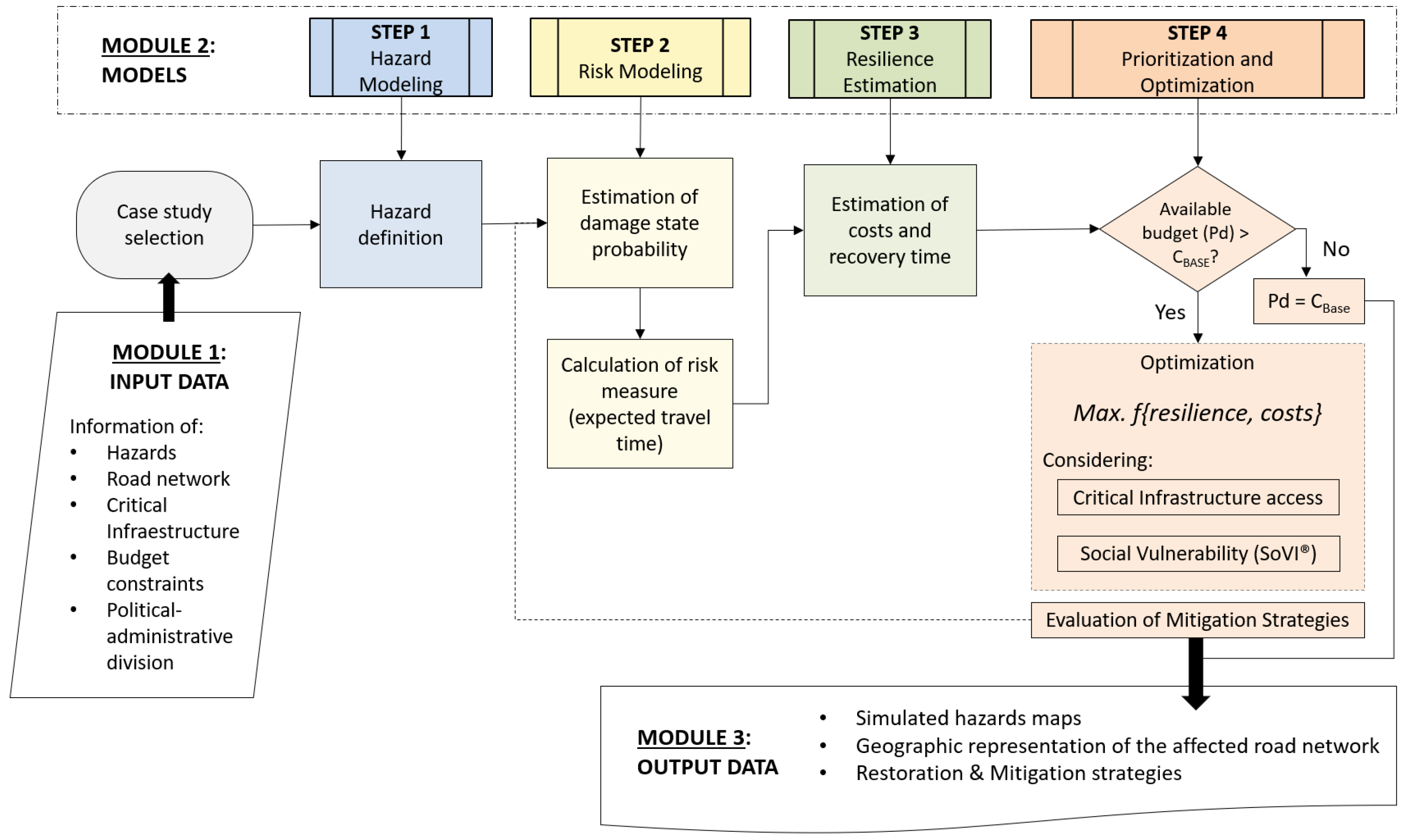
2. SIGeR-RV Risk Management System

SIGeR-RV is a web-GIS-based computational tool. This software was developed as part of a research and development project funded by the ANID (National Research and Development Agency of Chile) in collaboration with public and private agencies. The conceptual framework of SIGeR-RV (Figure 1) consists of three modules: input data, risk models, and outputs. A detailed description of the conceptual framework is in Chamorro et al. [3].

2.1. Module 1: Input Data

The first data set includes seismic, hydrometeorological, and volcanic hazard simulations. The second data set includes territorial geographic information on coastal lines, borders, and the country’s administrative configuration in a separate GIS interface. The third data set is linked to data on road infrastructure. It consists of the georeferenced Chilean road network and its related attributes. The fourth data set includes Critical Infrastructure (CI) information and the geolocation of educational centers, health systems, power stations, rural drinking water systems, emergency facilities, and safety services.

2.2. Module 2: Models

The first step refers to hazard modeling. In this step, the study area exposed to the selected natural hazard is simulated. Seismic hazard maps with 50,000 scenarios are considered for the Chilean subduction zone, whereas hydro-meteorological and volcanic hazards are uploaded as specific hazard maps. The second step considers risk modeling, estimated from calibrated fragility curves of assets exposed to the hazard under study and expressed in terms of an increase in travel time. Fragility curves represent the probability of an expected damage state given a certain hazard intensity [3]. An increase in travel time is estimated using traffic reassignment models based on user equilibrium principles [4]. The third step considers resilience assessment. Based on a user-defined budget, a mitigation and recovery plan is prepared [5]. SiGeR-RV has a pre-loaded library of recovery and mitigation strategies, including direct unit costs, user costs, and the duration of each strategy. Finally, recovery and mitigation strategies are optimized by minimizing the cost-benefit of each mitigation strategy and its effect on the overall resilience of the road network.

2.3. Module 3: Outputs

The software displays the following reports: (1) a graphical GIS representation of the study area with the road network and the simulated hazard; (2) tables with potentially damaged road assets; (3) a GIS representation of the affected road assets; (4) expected travel time for different simulated hazard scenarios; (5) a recovery and mitigation plan with recommended strategies, their costs, and duration; (6) a graphical representation of social vulnerability represented through the developed index; (7) a topological classification of the network; and (8) the most relevant roads that provide access to critical infrastructure.

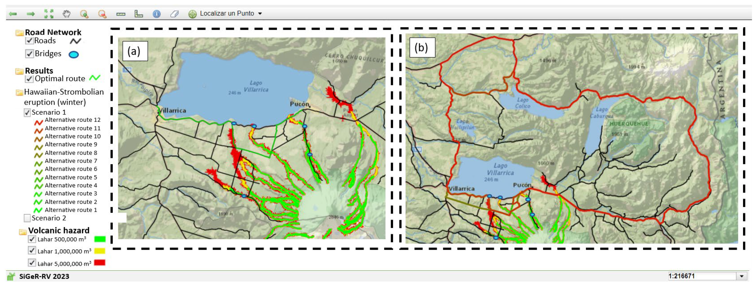
3. Case Study: Road Network Exposed to Volcanic Hazard

This case study comprises the road network between Villarrica and Pucón cities in the south of Chile that are exposed to laharic flows caused by potential eruptions of Villarrica volcano. Six scenarios were studied considering winter and summer seasons, Hawaiian-strombolian, subplinian, and plinian eruptions [6,7]. Bridge failure probabilities were estimated from fragility models calibrated by Dagá et al. [7].
Figure 2 presents the simulated lahars expressed as volumes of laharic material (in m3). From the interpolation of the road network, the hazard map, and the fragility curves calibrated by Dagá et al. [7], the failure probability of affected bridges is estimated. Optimal and alternative routes are assessed based on traffic assignment. Figure 2a shows the optimal route (in green) between Villarrica and Pucón after simulating the different volcanic scenarios. Figure 2b shows the alternative route (in red) for the Hawaiian-Strombolian eruption in winter. In some sections, the optimal and alternative routes coincide, whereas the alternative route differs by considering sections on the northern shore of Villarrica Lake. This alternative route, despite being a valid redundancy option, implies a considerable increase in travel time for users compared to the optimal route. This alternative route presents a travel time of 645 min compared to the optimal route of 32 min (see Figure 3).
Figure 3a presents detailed information on the probability of failure of affected assets for 10,000 iterations and the travel times for each of these iterations (Column 4). For example, in the scenario presented in Figure 3, 4 assets fail, with a failure probability between 8.7% and 17.8%. Producing an increase in travel times up to 645 min. Figure 3b reports the bridges that have failed in a certain scenario.
The case study evidences that four bridges are mainly affected by laharic flows for the different eruption scenarios that could occur in the Villarica volcano. Knowing these bridges, it is possible for road agencies to allocate resources toward improving the current condition of the bridges, either by implementing some mitigation measure to increase the standard of the asset or by planning in advance restoration measures for possible emergencies.

4. Conclusions

The Risk Management System assists decision-makers in managing the risk of road networks exposed to natural hazards. The article presents a risk management computational tool that allows simulating different natural hazards that affect road networks, territories, and developing communities in Chile. The tool was applied to a road network exposed to the laharic flows of Villarrica volcano.
The results evidence routes and road assets that are more likely to present damages when exposed to certain hazards, as well as alternative routes that provide redundancy to the network. From these results, resources can be efficiently allocated for the recovery and mitigation of road assets when exposed to a specific hazard.
It is important to consider that applying the developed framework and software to other territories with different characteristics and realities requires significant scientific development and model calibration.

Author Contributions

The contribution of the authors to the article is detailed below: study conception and design conceptualization: A.C., T.E., H.d.S. and C.P.; data collection: M.C.-J., E.A., N.N., J.D. and M.C.; analysis and interpretation of results: M.C. and J.D.; draft manuscript preparation: M.C.-J. and M.C.; review and editing, A.C., T.E. and H.d.S.; visualization, M.C. and M.C.-J.; supervision, A.C. and T.E.; project administration, A.C., H.d.S. and T.E.; funding acquisition, A.C. All authors have read and agreed to the published version of the manuscript.

Funding

This research was funded by the National Agency of Research and Development of Chile (ANID), Grant no. ID22I10037/FONDEF/ANID, and the Research Center for Integrated Disaster Risk Management (CIGIDEN) (Grant no. ANID/FONDAP/1522A0005).

Institutional Review Board Statement

Not applicable.

Informed Consent Statement

Not applicable.

Data Availability Statement

SiGeR-RV has models that have been developed from different databases that can be found in greater detail in the references mentioned [1,3,7], among others. In addition, the georeferenced data that serves as a base (for example, political and administrative division, international borders, and critical infrastructures) can be downloaded from the website https://www.ide.cl/ (accessed on 26 September 2023). In turn, georeferenced information about the road network can be obtained from the IDEMOP Platform (https://ide.mop.gob.cl/geomop/) (accessed on 26 September 2023).

Acknowledgments

The authors would like to acknowledge the National Agency of Research and Development of Chile (ANID) for funding the Project Grant no. ID14I20309/FONDEF/ANID.

Conflicts of Interest

The authors declare no conflict of interest.

References

  1. Allen, E.; Chamorro, A.; Poulos, A.; Castro, S.; de la Llera, J.C.; Echaveguren, T. Sensitivity analysis and uncertainty quantification of a seismic risk model for road networks. Comput.-Aided Civ. Infrastruct. Eng. 2021, 37, 516–530. [Google Scholar] [CrossRef]
  2. Free, M.; Anderson, S.; Milloy, C.; Mian, J. Geohazards risk management for infrastructure projects. Proc. ICE-Civ. Eng. 2006, 159, 28–34. [Google Scholar] [CrossRef]
  3. Chamorro, A.; Echaveguren, T.; Pattillo, C.; Contreras-Jara, M.; Contreras, M.; Allen, E.; Nieto, N.; de Solminihac, H. SIGeR-RV: A Web-Geographic Information System-Based System for Risk Management of Road Networks Exposed to Natural Hazards. Transp. Res. Rec. 2023. [Google Scholar] [CrossRef]
  4. Nie, Y.; Zhang, H.; Lee, D.-H. Models and algorithms for the traffic assignment problem with link capacity constraints. Transp. Res. Part B Methodol. 2004, 38, 285–312. [Google Scholar] [CrossRef]
  5. Rose, A.; Krausmann, E. An economic framework for the development of a resilience index for business recovery. Int. J. Disaster Risk Reduct. 2013, 5, 73–83. [Google Scholar] [CrossRef]
  6. INH. Construcción Mitigación Riesgos Volcánicos y Geológicos Asociados, Comunas de Villarrica, Pucón y Curarrehue, Región de la Araucanía; Instituto Nacional de Hidráulica: Santiago, Chile, 2013; Available online: http://www.inh.cl/home/documents/proyects/001-09-2014%20Ficha%20Estudio%20Riesgos%20volcanicos,%20regi%C3%B3n%20Araucan%C3%ADa_Estudio.pdf (accessed on 3 May 2023).
  7. Dagá, J.; Chamorro, A.; De Solminihac, H.; Echaveguren, T. Development of fragility curves for road bridges exposed to volcanic lahars. Nat. Hazards Earth Syst. Sci. 2018, 18, 2111–2125. [Google Scholar] [CrossRef]
Figure 1. Components and framework of the SIGeR-RV tool. Adapted with permission from Ref. [3]. 2023, Sage Journals.
Engproc 36 00068 g001
Figure 2. Case study results in map format. (a) the optimal route between Villarrica and Pucón cities. (b) an alternative route for Hawaiian-Strombolian eruptions in winter.
Engproc 36 00068 g002
Figure 3. Case study results in table format. (a) increased travel time of the alternative routes for the different volcanic scenarios. (b) bridges affected by the different scenarios analyzed.
Engproc 36 00068 g003
Disclaimer/Publisher’s Note: The statements, opinions and data contained in all publications are solely those of the individual author(s) and contributor(s) and not of MDPI and/or the editor(s). MDPI and/or the editor(s) disclaim responsibility for any injury to people or property resulting from any ideas, methods, instructions or products referred to in the content.

