1. Introduction
The practice of collecting, analyzing, and storing resources from other astronomical objects in order to seek substitute materials in outer space is known as in situ resource utilization (ISRU). ISRU is the possibility of setting bases in the future on other celestial bodies for humankind. Despite the great range of opportunities that ISRU could bring us, it is necessary to start with the compositions of those materials without the need to land on the surface. Throughout this paper, we intend to give first a state-of-the-art analysis to set in context the previous ideas and applications of similar ideas, then we describe the methods used in the studies to later give a comparison and complement with a proposal to apply this technology in space.
1.1. Motivation
Our motivation is a planet slowly dying at the hands of men. Humankind keeps growing and increasing the need for resources; soon the Earth will not be able to provide. When exploring new potential sources becomes a need, technological innovations must come to our aid. The investigation and recognition of new environments will be hard work which will implement the different use of multiple satellites and rovers until the unknown becomes the known. We set a proposal to form a map that, in the future, could be used as a navigation system, where spacecraft’s locations will not be a matter of pure late estimations.
1.2. Background
1.2.1. Case I
Being limited to the analysis of only visible physical properties, it is necessary to resort to characteristics such as color, whose information can provide a deeper description of the soil profile. An analysis of 136 soil samples carried out by the University of Moscow was based on the colorimetry of images using a digital camera to define the perception of the captured image. A high-resolution camera is necessary for topographic maps and photogrammetry; in addition, an infrared camera has the purpose of providing information about the soil’s composition throughout a spectral analysis of the light coming from the materials. The use of an optical camera is mainly related to infrared technology.
1.2.2. Case II
In 2021, the Institute of Earth Sciences of the Belgorod State National Research University in Russia conducted research applying colorimetry for the detection of soil color coordinates, in order to evaluate cultivable soil and its consequences on ancient structures, using an analysis of variance, permutations, and corrections in the sample data, which were helpful in determining the complexity of the soil composition and deciphering photographic images regarding color. Spectrometers allow one to determine the elements beneath the surface. Through generating a reflectance at certain wavelengths, spectrophotometers help to identify mineral materials depending on spectral signatures. A recent archaeological analysis on the Crimean Peninsula mapped its land formations through multispectral satellite pictures. The pictures were taken by the CORONA series of satellites, which receive panchromatic images from which measuring brightness, contrast, and texture was the key to recognizing boundary ramparts and obtaining coloring data. Laboratory results were given in previous spectrometric and colorimetric studies comparing the results with the implementation on deciphering images. The study was carried out with success, obtaining results of the morphology of the land and chemical composition through the use of colorimetry and satellite imagery; therefore, we intend to place this idea on a spatial context to map lands on other planets in order to help achieve a navigation system. All this is directly related to the classification of the different terrains according to their physical characteristics, allowing a mapping of the surface, which is possible thanks to the use of combined technologies such as cameras and the use of a spectroscope analyzing the luminosity of the materials [
1].
1.2.3. Case III
Agronomists, with their need to know the nitrogen contents of soil, have developed a system through multispectral imaging and AI. Information on nitrogen levels help them make decisions over how to treat crops in each area to maximize profits. They started with the idea of using satellite images of the land, which was functional but costly. Then, images were taken with drones and compared with an AI trained with machine learning to recognize the results of the multispectral analysis done on ground level samples and apply them on images taken from the sky. Using the correlation of nitrogen levels with chlorophyll meter measurements, a computer determined the percentage of each element in multispectral images. The data used from the aerial sensing were red, near-infrared, and green spectral bands, vegetation indices, air temperature, and humidity. For this kind of analysis many factors have to be taken into consideration, such as cloud interference, wind, and humidity. These alterations can send images with low quality that will not give precise results with machine learning. Applying these methods to the detection of elements in soils of another planet would allow us to work with more information without taking hundreds of samples back to Earth [
2].
1.2.4. Case IV
After the launch of the Hubble Space Telescope (HST), it was discovered that star formation in faint galaxies had small, compact, and physically high redshifts. Since then, the near-infrared band has been optimized with a larger aperture to more accurately determine the photometric redshift by fitting the template spectra to broadband colors. The James Webb Space Telescope (JWST) employs a near-infrared spectrograph (NIRSpec) having a capacity of more than 100 simultaneous multiobjects in a field of view of several arcminutes, with the aim of improving studies on the astronomical observations of celestial bodies, with greater possibilities of finding hidden exoplanets and solving other astronomical problems that were limited by the operating range. In this paper, the same technique is used for the detection of celestial bodies, their composition, and the surface evaluation of materials [
3].
1.2.5. Case V
In surface exploration missions using rovers, antennas play an important role for ground control. Space exploration vehicles such as Curiosity or Perseverance are equipped with three antennas, an ultrahigh frequency (UHF) that is in charge of transmitting data to earth trough independent orbiters, a high-gain antenna to transmit data directly to earth, and low-gain antenna to receive data [
4].
2. Methods for Observation and Monitoring
2.1. Case I
Within the study at the University of Moscow, the digital camera used was a 21.1-megapixel Sony DSC-HX50, with an Exmor R CMOS sensor, Sony Semiconductor Kyushu Corporation’s Nagasaki Technology Center, that improved the quality of images in low-light environments by working as a noise filter. An RGB color technique was used to map the surface according to the brightness of the object with the help of a spectrometer. A normalization standard was applied to subsequently convert the plane values from XYZ-space coordinates to RGB color coordinates in order to adjust them and make corrections for their categorization, also taking into account the calibration in the camera. Another use for the digital camera was to map the surface by altitude, depending on the change in the distribution of materials, patterns, and geometries [
5].
2.2. Case II
In the case of the analysis of land in the Crimean Península, two types of spectrometers were used. The first, a wavelength-dispersion X-ray fluorescence spectrometer (Spectroscan Max-GVM, St.Petersburg, Russia) helped to determine the chemical composition of soils. The coloring was described using the Munsell system. Color measurements were taken in laboratory conditions using an AvaSpec-2048 optical spectrometer, a standard light source AvaLight-DHc, a bifurcation fiber optic cable, standard white WS-2, and a computer with AvaSoft8.10 installed. Each sample was measured three times to take the mean value of the color coordinates. The data obtained were then processed in RStudio, applying statistical methods to visualize the analysis of variance and the comparisons [
1].
2.3. Case III
A
Sentera high-precision NDVI single sensor, Saint Paul, MN, USA, used a 1.2 MP CMOS with a
horizontal FOV and a
vertical FOV that worked with two spectral bands, red and NIR, with a pixel count of 1248 horizontal/950 vertical. The sensor weighed 30 g and could be attached to an unmanned aerial vehicle such as the Mavic 2 Pro that was used for the study. A total of 865 multispectral images were analyzed and compared with 54 soil samples that were taken with a hydraulic probe. Then, the spectrometer measured the intensity reflected through the material for each wavelength to determine the nitrogen concentration in each patch of land. A band separation for each spectrum (near-infrared, red, and green) was realized and measured with colored pixels to obtain parameters to work with the machine learning. Once parameters were set, they were put through a neural network to optimize the processing of the images. Errors were measured with the RMSE (root-mean-square deviation) on the multilayer perceptron regression and support vector regression machine learning methods [
2].
2.4. Case IV
The near-infrared spectrograph (NIRSpec) used by the James Webb Space Telescope (JWST) has an infrared wavelength range of 0.6 to 5.3 µm with three modes of spectral resolutions of R’100 for redshifts, R’1000 for measuring nebular emission lines, and R’2700 for kinematic studies with emission lines. It contains seven main components: front optics, filter wheel, slit plane, collimator optics, grating wheel, camera optics, and detector array. The light path arrives along the plane of the orthogonal dispersion optical bench, which is made of silicon carbide (SiC), maintaining the stability of the instrument in orbit due to its high thermal conductivity and very low thermal expansion. Its cooling is provided by passive refrigeration, with a radiator and an insulating layer that are light-tight. In conjunction with the above, a high-fidelity software model has been developed that allows the tracking of the light path with an accuracy of a fraction of a pixel, while containing a data reduction and observation planning software. The task of the pick-off mirrors and foreoptics is to create an image of a demagnified section of the local sphere to ensure the best possible image quality, whereby the foreoptics refocuses the image telecentrically, which also makes the image scale in the slit plane insensitive to changes in viewing focus. The latter module contains an eight-position filter wheel with five long-pass order-separation filters, two finite-band target acquisition filters, and an eighth shutter position. Multiobject spectroscopy employs a microshutter array (MSA) for the multipositioning of the light. It is a purely interesting concept, which can be realized on a smaller scale than in the original hardware, if the use of several panels used in the MSA is reduced, and if only one alignment with a much smaller aperture is focused on, considerably reducing the size, weight, and cost, while retaining functionality, adapting to the needs of a medium range observation [
3].
2.5. Case V
For the communications, the three-antenna system could be adapted on the satellite for the soil analysis. The ultrahigh frequency antenna at 400 MHz could be in charge of the transmission of data to earth but just with the help of other orbiters around the celestial body under study. These orbiters could make an extension of the information route instead of use long-range telecommunications and depending completely on the antennas for transmitting to earth. Moreover, using the steerable high-gain antenna of a radiofrequency that goes from 7 to 8 GHz is an advantage in order to save energy, by moving only the antenna in the direction of the earth’s position instead of changing the position of the whole satellite. Finally, in the three-antenna system there is a low-gain antenna of 7 to 8 GHz focused on the reception of signals; its main distinctive characteristic is that it is omnidirectional so it does not need to be pointed at earth in order to establish communication with the satellite [
4].
3. Discussion
3.1. Satellite Structure
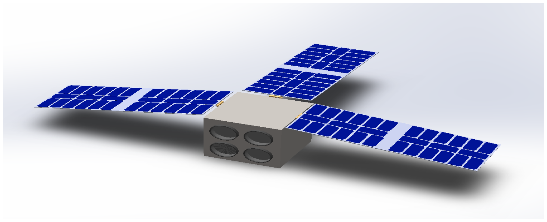
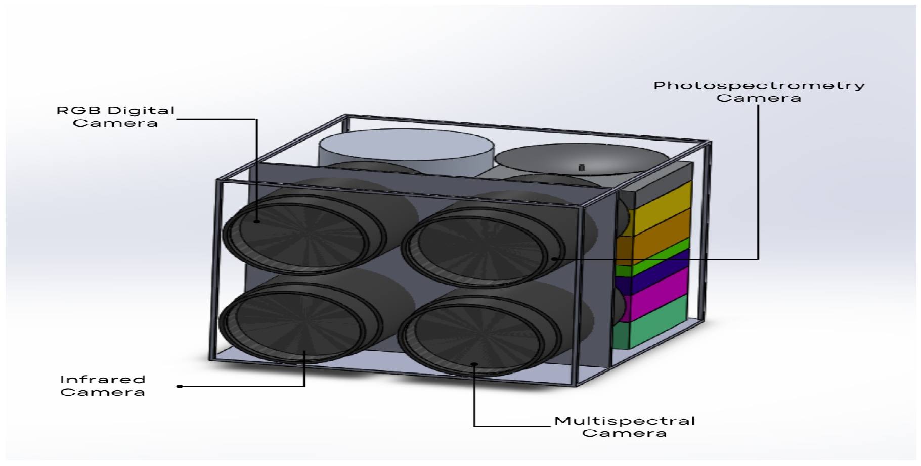
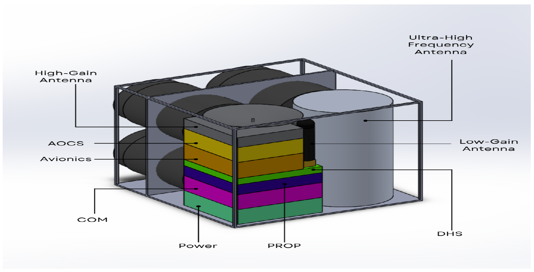
Based on the principles of the satellite architecture, the proposal is based on a satellite that packs the four cameras, three antennas, and the whole communications system and basic hardware components.
Figure 1 and
Figure 2 show the proposed system. Among the main hardware components are:
A RGB digital camera and a photospectrometry camera;
A multispectral camera and a infrared camera;
Ultrahigh frequency and high/low-gain antennas;
A communications module (COM);
A power module and a propulsion module (PROP);
An altitude and orbit control system (AOCS);
A data-handling system (DHS).
3.2. Orbit Architecture
The objective of this proposal is merely strategic for the placement of this type of satellites for the monitoring of celestial bodies in the cosmos; primarily, the sensors we propose would be sent to orbit in low orbits, where it is possible to measure the variables and determine the characteristics of celestial bodies. We expect to receive interference due to unknown elements and some inaccurate data. Thus, we propose to realize multiple measurements in the same patch for at least 1 week to get an average value for the color coordinates, the elements found by the spectrometers, and environmental factors. The more measurements, the better.
3.3. Interplanetary Internet Node
The satellite structure, besides having the objective of analyzing and monitoring celestial bodies, is a node for the interplanetary Internet structure, see
Figure 3. The production and putting into orbit of more than one of these satellites could represent one of the pillars of communication in space without the need for a terrestrial base (NTN) and contribute to the acquisition of scientific data of interest for the future establishment of bases on other planets [
6].
3.4. Expectations
The idea of detecting soils through images from another planet would require numerous previous studies of the soil to work on AI and machine learning tools to recognize its components. It is a process that would also take much image processing power and storage to keep track of the results in order to form a map and use similar results to speed up the process. We also need to take into account that since environmental conditions have factors we may know nothing about, the number of pictures per patch of land to obtain a single color coordinate must increase, to ensure the best estimations in cases where storms or clouds could be interfering with the camera on certain days. Another problem would the fact that the best images would be obtained closer to the surface so satellites could only work aligned to the lower orbits for the method to show good results. On the other hand, the position and angle of the satellite is crucial for the mission to plan. Cameras must get an accurate visual aid from the satellite infrastructure and position. The satellite established on a low orbit would travel at higher speeds which would complicate the picture-taking process.
4. Conclusions
Our proposal turns out to be very feasible due to the cost-benefit analysis involved in its development, production, and construction, as well as in its implementation to monitor the cosmos, while it becomes one more node for an interplanetary Internet infrastructure. Developing plans to map a celestial body can be very expensive and complicated. In this paper, we proposed a method to facilitate the exploration and detection of soils while mapping landforms and establishing coordinates for positioning new machinery. Instead of producing soil samples after soil samples and then dealing with the cost and effort of shipping them to Earth, our method of colorimetry and image processing would reduce the need for samples and maintain samples for larger land areas. With this proposal, the launch costs would be reduced, due to the compact size of the satellite, as well as fewer landing missions on celestial bodies for analysis on their chemical composition. This method recognizes larger ground arrays with nanosatellites that are much lighter and cheaper to produce and work with. In addition, we know the importance of preserving the nature of the cosmos, being aware that the techniques used in this proposal do not represent a risk or do not involve damage to the study surface. This is long-term work that will allow future missions to localize with much ease.
Author Contributions
Conceptualization, S.Z.C.-G. and K.A.; methodology, S.Z.C.-G., C.E.D.-B. and K.A.; investigation, S.Z.C.-G., K.A. and J.M.G.-T.; resources, J.M.G.-T. and C.V.-R.; writing—original draft preparation, everyone; writing—review and editing, C.V.-R.; supervision, C.V.-R. and J.M.G.-T. All authors have read and agreed to the current version of the manuscript.
Funding
This research received no external funding.
Institutional Review Board Statement
Not applicable.
Informed Consent Statement
Not applicable.
Data Availability Statement
Not applicable.
Acknowledgments
The administrative and technical support was given by Cesar Vargas-Rosales.
Conflicts of Interest
The authors declare no conflict of interest.
References
- Ukrainskiy, P.; Lisetskii, F.; Poletaev, A. Differentiating soils from arable and fallow land using spectrometry. Soil Syst. 2021, 5, 54. [Google Scholar] [CrossRef]
- Hossen, M.A.; Diwakar, P.K.; Ragi, S. Total nitrogen estimation in agricultural soils via aerial multispectral imaging and LIBS. Sci. Rep. 2021, 11, 12693. [Google Scholar] [CrossRef] [PubMed]
- Ferruit, P.; Jakobsen, P.; Giardino, G.; Rawle, T.; de Oliveira, C.A.; Arribas, S.; Beck, T.; Birkmann, S.; Böker, T.; Bunker, A.; et al. The Near-Infrared Spectrograph (NIRSpec) on the James Webb Space Telescope-II. Multi-object spectroscopy (MOS). Astron. Astrophys. 2022, 661, A81. [Google Scholar] [CrossRef]
- NASA. Communications-Ultra-High Frequency Antenna, NASA’s Mars 2020 Perseverance Rover, NASA. Available online: https://mars.nasa.gov/mars2020/spacecraft/rover/communications/#UHF-Antenna. (accessed on 7 December 2022).
- Al-Naji, A.; Fakhri, A.B.; Gharghan, S.K.; Chahl, J. Soil color analysis based on a RGB camera and an artificial neural network towards smart irrigation: A pilot study. Heliyon 2021, 7, e06078. [Google Scholar] [CrossRef] [PubMed]
- Kodheli, O.; Lagunas, E.; Maturo, N.; Sharma, S.K.; Shankar, B.; Montoya, J.F.M.; Duncan, J.C.M.; Spano, D.; Chatzinotas, S.; Kisseleff, S.; et al. Satellite communications in the new space era: A survey and future challenges. IEEE Commun. Surv. Tutorials 2020, 23, 70–109. [Google Scholar] [CrossRef]
| Publisher’s Note: MDPI stays neutral with regard to jurisdictional claims in published maps and institutional affiliations. |
© 2022 by the authors. Licensee MDPI, Basel, Switzerland. This article is an open access article distributed under the terms and conditions of the Creative Commons Attribution (CC BY) license (https://creativecommons.org/licenses/by/4.0/).


 ,
, 