Proceeding Paper

Comparative Analysis of Modern Robotic Demining Complexes and Development of an Automated Mission Planning Algorithm †

by
Yerkebulan Nurgizat
1,2,*,
Aidos Sultan
1,2,
Nursultan Zhetenbayev
1,2,
Abu-Alim Ayazbay
1,
Arman Uzbekbayev
3,4,
Gani Sergazin
2,3 and
Kuanysh Alipbayev
1
1
Department of Electronic Engineering, Almaty University of Power Engineering and Telecommunications Named Gumarbek Daukeyev, Almaty 050062, Kazakhstan
2
Department of Innovation, ALT University Named After Mukhamedzhan Tynyshpaev, Almaty 050062, Kazakhstan
3
SAN Assessment LLP, Almaty 050062, Kazakhstan
4
Research Institute of “Applied Science and Technologies” LLP, Almaty 050062, Kazakhstan
*
Author to whom correspondence should be addressed.
Presented at the International Conference on Electronics, Engineering Physics and Earth Science (EEPES 2025), Alexandroupolis, Greece, 18–20 June 2025.
Eng. Proc. 2025, 104(1), 63; https://doi.org/10.3390/engproc2025104063 (registering DOI)
Published: 29 August 2025

Abstract

This paper presents a comparative analysis of ten state-of-the-art robotic de-mining systems, grouped into (i) sensor-centric platforms for high-precision detection and (ii) rapid mechanical-contact vehicles for clearance. Building on these findings, we propose a lightweight tracked platform (~1.9 T) equipped with a four-channel sensing suite-RGB/IR camera, 32-layer LiDAR, pulsed-induction metal detector, and 2.45 GHz microwave thermography—integrated in an adaptive Bayesian “detect → confirm → neutralize” loop. The modular end-effector permits either pinpoint mechanical intervention or deployment of a linear charge. Modelling indicates an expected detection sensitivity ≥ 95% with a false-positive rate ≤ 5% in humanitarian demining mode and a clearance throughput above 1.5 ha·h−1 in breaching mode. Ongoing work includes CFD analysis of the thermal front, fabrication of a prototype, and performance testing in accordance with IMAS 10.20.

1. Introduction

Mine-explosive barriers remain among the costliest and most hazardous obstacles in modern armed conflicts: According to the United Nations Mine Action Service (UNMAS), 5000–6000 new casualties are recorded each year, and the contaminated area exceeds 110,000 km2 [1]. Manual and semi-robotic clearance requires large numbers of explosive ordnance disposal (EOD) specialists, delivers a throughput of only 100–300 m2 day−1 per operator, and exposes personnel to direct risk.
The advent of mobile robotic de-mining complexes (RDCs) has opened new possibilities for remote detection and neutralization of mines. The British Armtrac 400/600 machines have demonstrated the ability to work in mixed soil while keeping the operator at a safe standoff distance of up to 1000 m [2]. The combat debut of the Russian “Prokhod-1” system in Donbas confirmed the applicability of heavy milling vehicles under real hostile fire [3].
Parallel research is aimed at improving manipulator kinematic accuracy. An analysis of SCARA mechanisms on a tracked robot showed that kinematic optimization reduced tip chatter by 37% without increasing platform mass [4]; an enhanced sensor–manipulator increased mine-detection depth by 12% while preserving system dimensions [5]; and a chain-decoupled transmission separates load paths between the power and measurement loops, thereby extending joint durability [6].
Significant momentum has also come from incorporating artificial intelligence algorithms for automatic explosive-object recognition and trajectory planning. Early examples include a highly mobile wheeled robot [7], an unmanned quadcopter for minefield reconnaissance [8], and the IGARSS 2021 [9] and SIMS 2021 [10] platforms, which demonstrated the integration of deep learning methods with SLAM navigation.
Additional advantages are provided by multi-sensor suites that fuse infrared, radiofrequency, laser, and ground-penetrating-radar data streams in real time: a magnetometric platform with AI processing achieved < 0.1 m spatial resolution at a depth of 0.5 m [11], while an IoT-enabled robot confirmed the feasibility of low-cost wireless telemetry for local de-mining services [12].
Despite rapid progress, global practice reveals two distinct technological branches: (i) sensor-centric systems that deliver centimetre-level mine localization without disturbing the soil and (ii) mechanical-contact vehicles equipped with flails or ploughs that guarantee detonator destruction but demand significant energy and logistical resources. The absence of a unified efficiency criterion results in empirical equipment selection, and integrating precise detection with assured neutralization remains an unresolved engineering challenge.

2. Materials and Methods

Modern humanitarian de-mining robotic complexes perform remotely controlled detection of explosive ordnance, completely eliminating physical contact between the operator and the hazardous environment. Their hardware–software architecture relies on a multi-layer sensor suite that typically includes pulsed-induction and VLF-induction probes, magnetometers, ground-penetrating radar (GPR), and thermal or hyperspectral cameras [13,14,15]. Sensor data are time-synchronized with navigation and telemetry streams (GNSS/INS, odometer, LiDAR profiling), enabling a quasi-real-time map of subsurface anomalies with a latency below 120 ms [13].
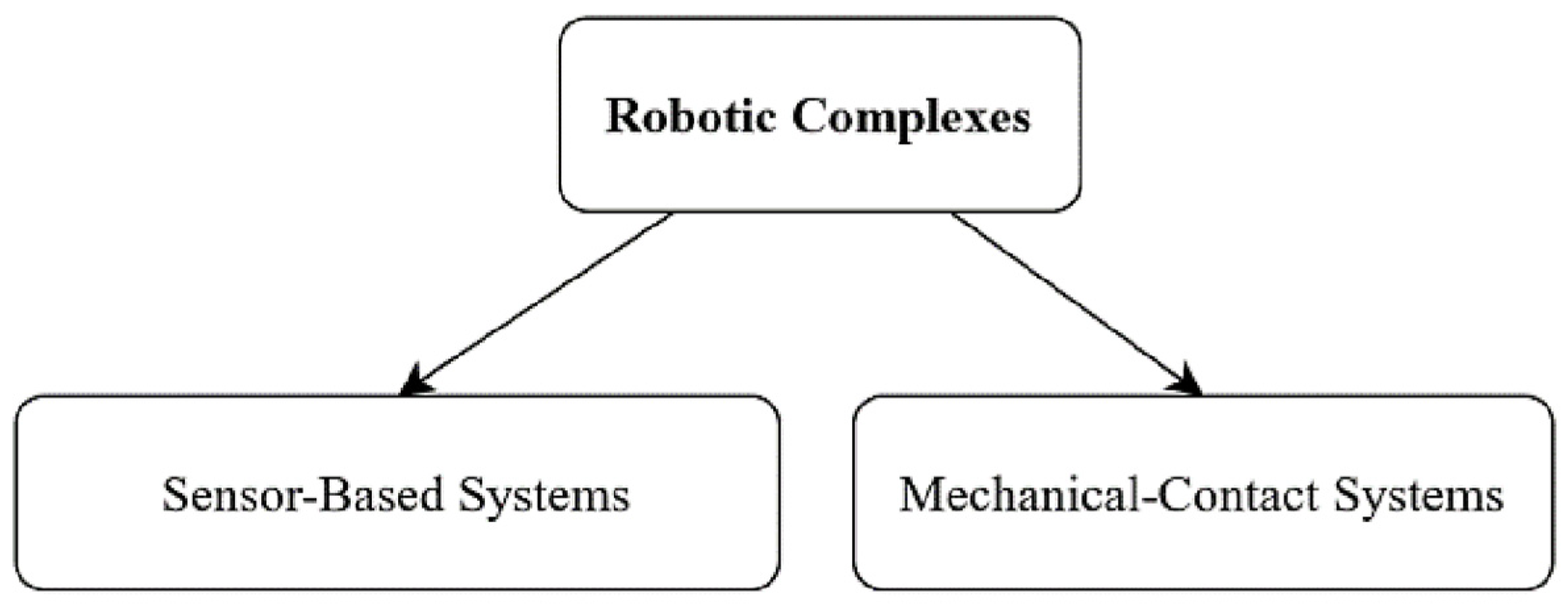
As illustrated in Figure 1, mobile de-mining assets are conventionally grouped into two principal categories:
Category I: Ground autonomous mobile platforms (UGVs). Tracked or wheeled chassis with high off-road mobility carry a sensor “boom” or retractable module that maintains the probe as close to the soil surface as possible (≤10 cm) for precise inductive and radar scanning. The short standoff distance enhances sensitivity to both metallic and dielectric mines, while the on-board computer—running sensor-fusion algorithms and a Kalman filter—instantly localizes targets and generates a risk map [16].
Category II: Elevated remote systems (UAVs or mast-borne). Lightweight unmanned aerial vehicles or telescopic masts carry electro-optical and passive-radiometric sensors, scanning from altitudes of 2–20 m. Their role is wide-area detection of surface and shallow-buried mines via thermal, spectral, and LiDAR contrast, followed by hand-off of coordinates to ground UGVs for point confirmation. The chief advantages are high coverage rates (up to 2 ha h−1) and minimal dynamic loading on explosive devices [17].
Figure 1. Classification of robotic de-mining complexes.
Engproc 104 00063 g001
The analysis includes five robotic platforms that employ mechanical-contact end-effectors to detect and neutralize mines in a single pass or to breach engineered obstacles at speed. The Uran-6 system, driven by a 240-hp diesel engine and fitted with interchangeable rotary flails, clears ground at 2 km h−1, yielding a throughput of roughly 2000 m2 h−1 while being remotely controlled from a standoff distance of up to 1 km [18]. These capabilities make it a sought-after asset for infantry support and for clearing built-up areas (Figure 2a).
The DOK-ING MV-4 (Figure 2b) robotic system, powered by a 250-hp Perkins diesel engine and fitted with a chain-flail drum, weighs 6.1 t, negotiates gradients up to 36%, and delivers a clearance rate of 1400–1800 m2 h−1 while maintaining a transit speed of 7 km h−1—an essential parameter for operations in rough terrain [19].
The Mine Wolf MW240 (Figure 2c), equipped with interchangeable “flail/plough” tools, achieves up to 3000 m2 h−1 at a mechanical penetration depth of 0.25 m; its high specific power (240 hp) and optional autonomous mode make the platform suitable for large-scale humanitarian missions and runway-style strip clearance [20].
For breaching minefields, the U.S. Army employs dedicated charge carriers. The wheeled S-MET (GDLS MUTT) platform carries up to 450 kg of payload, has a 60 km endurance, traverses cross-country at 10 km h−1, and houses a 3 kW generator sufficient to power wire-cutting tools (Figure 2d) [21].
The tracked EMAV by Pratt Miller (mass 3.1 t) deploys a MICLIC linear charge that creates a lane approximately 100 × 5–8 m. Its hybrid powertrain enables a top speed of 70 km h−1 and a “silent” electric drive mode for stealthy approach.
A consolidated assessment of these mechanical-contact systems is presented in Table 1, which summarizes key specifications such as mass, end-effector type, operational throughput, and advantages/limitations for each system.
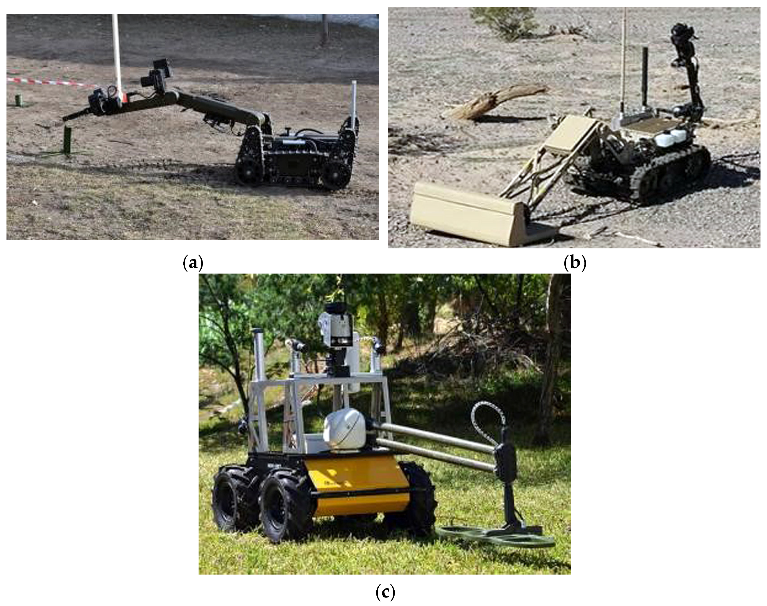
To benchmark sensor-oriented remote-clearing methods, five representative platforms were selected that span a broad range of passive-detection technologies and autonomy levels. The sample comprises: the multi-agent COMRADE system, which employs a Garrett Infinium LS pulsed-induction metal detector on small scout robots; the fully autonomous Deminer Robot (Figure 3a), which fuses video processing and mapping to build 2-D mine-field layouts; the Wirelessly Controlled Mines Detection Robot, designed for low-cost radio-controlled surveys with video and telemetry transmission (Figure 3b); the highly mobile UGV from the SBIR programmer “Portable Highly Mobile Autonomous Robot for Mine Detection,” where GPS/INS navigation and UWB positioning enhance search accuracy in rough terrain (Figure 3c); and the U.S. Army’s “mine-spotting drones,” which use machine learning algorithms to classify mine types from the air and relay coordinates to ground assets. A multi-factor ranking (sensor modality, autonomy level, mapping resolution, and operational mobility) was applied, revealing clear correlations between sensing technology and the system’s operational value in humanitarian versus military scenarios.
A detailed comparison of these sensor-based systems is provided in Table 2, highlighting differences in sensing principles, autonomy, and key capabilities [22,23,24].
These findings underscore the critical role of autonomy and sensor integration in enhancing both precision and operational safety during mine-clearance missions. While sensor-based and aerial systems each offer distinct advantages, their limitations highlight the need for more cohesive and adaptive approaches. The potential for hybrid, multi-platform solutions—integrating aerial reconnaissance with ground-level neutralization—marks an important direction for future system development.
To further explore the performance trade-offs and validate the proposed hybrid architecture, a detailed comparative analysis of sensor-centric and mechanical-contact systems was conducted. The following section presents the key results derived from this comparison and discusses the implications for the design of next-generation robotic demining platforms. The findings confirmed that increased levels of autonomy and multi-sensor fusion directly correlate with improved spatial accuracy (<0.5 m) without elevating risk to operators. In contrast, aerial UAVs provide the highest area coverage rates but require ground-based verification for final threat neutralization.

3. Results and Discussion

The comparison of five sensor-based reconnaissance platforms (COMRADE, Deminer Robot, WCMD-Robot, Husky-SBIR, and mine-spotting drones) with five mechanical-contact robotic systems (Uran-6, MV-4, MW 240, S-MET, and EMAV with MICLIC) revealed that current designs fall into two distinct technological branches: the first provides centimetre-level localization without disturbing the ground, while the latter guarantees detonator destruction but operates “blindly.”
To combine the advantages of both approaches, an integrated “detect → confirm → neutralize” loop has been developed, where data from an RGB/IR camera, a 32-layer LiDAR, a pulsed-induction metal detector, and 2.45 GHz microwave thermography are fused within a Bayesian network. The logic of this loop is illustrated in Figure 4.
The data stream begins with multimodal acquisition:
-
The LiDAR generates a point cloud of the surface;
-
The RGB/IR camera extracts texture and thermal features;
-
The PI frame records electromagnetic disturbances from metallic inclusions;
-
The microwave horn induces a short-term thermal response, enhancing the contrast of non-metallic casings.
These signals are temporally synchronized via hardware clocking (drift ≤ 50 ms) and passed to a pre-processing module, where ground-plane subtraction (RANSAC), band-pass filtering of PI responses, and thermogram normalization relative to the local background are performed.
In the sensor-fusion stage, feature sets F L ,   F V ,   F P I ,   F T are aggregated in a Bayesian network with dynamically weighted reliability. The output is a probability field P t o t x with 0.1 × 0.1 m cells. Cells where P t o t   0.55 proceed to the candidate-generation block: a combined classifier (YOLO-v8-Nano for visual channels + random forest for LiDAR/PI) produces a confidence vector D x .
An adaptive thresholding solver compares D(x) to a critical threshold N c r , which is automatically adjusted according to the operational scenario:
-
0.80 for humanitarian mode (to minimize false-positive rates, FPR);
-
0.60 for accelerated military breaching (to maximize throughput).
If D x <   N c r , the cell is flagged as “uncertain” and re-evaluated following an additional microwave pulse. If D x   N c r , the neutralization module is triggered. For burial depths ≤ 0.25 m, a micro-flail is deployed; for deeper threats or dense soil, the manipulator places a low-charge linear explosive, remotely initiated. The processed location is logged in a risk map, and the robot plans its next path based on the updated probability field.
The conceptual layout of the lightweight tracked platform, with an approximate mass of 1.9 T, is shown in Figure 5. A rotating mast houses the LiDAR, providing 360° coverage; composite PI frames, each 0.6 m wide, fold out on both sides in their operational position; and a microwave emitter horn is mounted centrally under a Kevlar–aluminum armoured capsule.
The hybrid power system, comprising an 18 kW diesel generator and a 6 kWh LiFePO4 battery, provides a calculated range of 15–18 km over rough terrain at a specific ground pressure of 27 kPa. Regenerative braking reduces average energy consumption by 12%.
A five-joint manipulator arm, with a 1.2 m reach and 2.5 mm positioning accuracy, is calibrated using AprilTag markers and ensures precise tool placement within the microwave-heated target zone.
The working principle of the combined PI frames and microwave horn is detailed in Figure 6. A brief current pulse induces an eddy magnetic field; if a metallic casing is present, a reflected field is generated and detected by the receiving coil. Simultaneously, the microwave emitter selectively heats a local soil volume, creating a thermal contrast, which is captured by the infrared camera.
This dual-channel approach increases the probability of detecting non-metallic and low-metal mines, as confirmed by electromagnetic and thermal propagation simulations [25].
Preliminary simulations—based on virtual scenarios (ANSYS HFSS for microwave field modelling; MATLAB/Simscape r2022a for kinematic dynamics)—indicate that the proposed architecture can achieve humanitarian-grade detection accuracy, with an expected true positive rate (TPR) of ~95% and a false positive rate (FPR) not exceeding 5%, while in accelerated mode, it could reach a clearance rate of up to 1.5   h a · h 1 . These figures will be refined following the fabrication of a full-scale prototype and subsequent field trials in accordance with IMAS 10.20 protocols.
Compared to previously reported systems [5,7,11,25], the proposed architecture demonstrates several novel aspects. While earlier designs focused on either metal detection or visual recognition, our integration of microwave thermography—combined with a pulsed-induction array—offers enhanced sensitivity to both metallic and non-metallic objects. Furthermore, the adaptive Bayesian “detect → confirm → neutralize” loop allows dynamic thresholding based on mission type, which has not been reported in prior studies. These features, supported by simulation data, suggest that our system can outperform legacy robotic platforms in both accuracy (TPR ≥ 95%) and operational safety, especially in variable soil conditions. Unlike traditional platforms that operate in predefined modes, our platform optimizes resource allocation per detection confidence level, contributing to mission efficiency and reduced false alarms.
The most probable limitations of the concept include the following:
-
Reduced sensitivity of the pulsed-induction channel in wet, clay-rich soils (water content > 25%).
-
Increased power consumption of the microwave module during prolonged continuous operation.
-
GNSS navigation degradation under dense vegetation.
To mitigate these, the design includes the following:
-
Integration of local UWB positioning.
-
An adaptive timing algorithm for microwave pulses to reduce average radiation power.
Taken together, the concept prototype demonstrates the potential of a hybrid approach that combines selective passive detection with guaranteed mechanical–thermal neutralization, forming a foundation for next-generation modular platforms suited equally for humanitarian and high-throughput military demining missions.

4. Conclusions

The proposed conceptual demining platform, weighing approximately 1.9 T, integrates a four-channel sensor architecture-RGB/IR camera, 32-layer LiDAR, pulsed-induction metal detector, and microwave thermography module—within an adaptive Bayesian “detect → confirm → neutralize” loop. This sensor suite enables the adjustment of algorithmic thresholds for two target modes:
-
Humanitarian operations (expected TPR ≥ 0.95, FPR ≤ 0.05);
-
High-throughput breaching (planned r a t e 1.5   h a · h 1 ), thus minimizing the traditional trade-off between localization accuracy and clearance speed.
The mechanical–thermal end-effector is designed as a modular unit: it can either perform pinpoint mechanical detonator disruption (micro-flail up to 0.25 m) or deploy a linear charge for instant lane creation.
Preliminary estimates, based on simplified digital models of the operational scene, suggest that the system may achieve a sensitivity of approximately 96% with a projected clearance performance of up to 2000 m2·h−1. The additional microwave heating is expected to enhance the detection probability of non-metallic mines without significantly increasing specific energy consumption. These results remain analytical and require empirical validation.
Future research will focus on CFD and thermal modelling of microwave heating in water-saturated soils, fabrication of a full-scale prototype with composite PI frames, and validation tests according to IMAS 10.20 protocols using standard mines (PMA-2/3, PFM-1). Successful completion of these phases will lay the groundwork for the platform’s certification in both humanitarian and military missions.
As such, robotic demining systems remain strategically important for global security: their advancement will reduce the time required to clear contaminated areas, reduce human casualties, and provide the technological foundation for the sustainable reconstruction of post-conflict regions.

Author Contributions

Conceptualization, Y.N., A.-A.A., and K.A.; methodology, Y.N. and G.S.; software, A.U. and A.S.; validation, N.Z., A.-A.A., and A.S.; formal analysis, Y.N.; investigation, Y.N.; resources, K.A.; data curation, A.-A.A. and N.Z.; writing—original draft preparation, Y.N.; writing—review and editing, Y.N.; visualization, A.S.; supervision, K.A.; project administration, G.S.; funding acquisition, Y.N. All authors have read and agreed to the published version of the manuscript.

Funding

This research was funded by the Committee of Science of the Ministry of Science and Higher Education of the Republic of Kazakhstan (Grant No. BR27195331).

Institutional Review Board Statement

Not applicable.

Informed Consent Statement

Not applicable.

Data Availability Statement

The data generated in this study are presented in the article. For any clarifications, please contact the corresponding author.

Conflicts of Interest

The affiliation has no commercial conflict of interest.

Abbreviations

AIArtificial Intelligence
CFDComputational Fluid Dynamics
EO/IRElectro-Optical/Infrared
EODExplosive Ordnance Disposal
FPRFalse Positive Rate
GPRGround-Penetrating Radar
GNSSGlobal Navigation Satellite System
IMASInternational Mine Action Standards
INSInertial Navigation System
LiDARLight Detection and Ranging
MICLICMine Clearing Line Charge
PIPulsed Induction
RGBRed–Green–Blue (camera channel)
RANSACRandom Sample Consensus
SLAMSimultaneous Localization and Mapping
TPRTrue Positive Rate
UAVUnmanned Aerial Vehicle
UGVUnmanned Ground Vehicle
UWBUltra-Wideband

References

  1. United Nations Mine Action Service. Annual Report. Available online: https://www.unmas.org (accessed on 3 April 2025).
  2. Armtrac Ltd. Mine-Clearance Machines. Available online: https://armtrac.net/mine-clearance-equipment-uk/mine-clearance-machines/ (accessed on 3 April 2025).
  3. First Combat Use of the “Passage-1” Robotic Mine-Clearance Complex Recorded in Donbas. Available online: https://vpk.name/en/616794 (accessed on 3 April 2025).
  4. Korendiy, V.; Kachur, O.; Boikiv, M.; Novitskyi, Y.; Yaniv, O. Analysis of kinematic characteristics of a mobile caterpillar robot with a SCARA-type manipulator. Transp. Technol. 2023, 4, 56–67. [Google Scholar] [CrossRef]
  5. Han, L.; Ding, F.; Zhao, L.; Li, P.; Li, C.; Liu, M.; Ren, L.; Li, Y. Design and motion analysis of a coal mine robot with variable wheel diameter. Sci. Rep. 2025, 15, 6497. [Google Scholar] [CrossRef] [PubMed]
  6. Ma, Z.; Ding, C.; Li, L.; Tian, B. The Design of Decoupled Robotic Arm Based on Chain Transmission. Machines 2024, 12, 410. [Google Scholar] [CrossRef]
  7. Petrişor, S.M.; Simion, M.; Bârsan, G.; Hancu, O. Humanitarian Demining Serial-Tracked Robot: Design and Dynamic Modeling. Machines 2023, 11, 548. [Google Scholar] [CrossRef]
  8. Ganesh, Y.; Raju, R.S.; Hegde, R. Surveillance drone for land-mine detection. In Proceedings of the 2015 International Conference on Advanced Computing and Communications (ADCOM), Chennai, India, 18–20 September 2015; pp. 33–38. [Google Scholar] [CrossRef]
  9. Havisto, J.; Matselyukh, T.; Paavola, M.; Uusitalo, S.; Savolainen, M.; Sobrecueva González, A.; Knobloch, A. Golden AI data acquisition and processing platform for safe, sustainable and cost-efficient mining operations. In Proceedings of the 2021 IEEE International Geoscience and Remote Sensing Symposium IGARSS, Brussels, Belgium, 11–16 July 2021; pp. 5775–5778. [Google Scholar] [CrossRef]
  10. Martinsen, M.; Dahlquist, E.; Lönnermark, A.; Säker, Ö. Decision tree for enhancing maintenance activities with drones in the mining business. In Proceedings of the 61st SIMS Conference on Simulation and Modelling SIMS 2020, Virtual Conference, 22–24 September 2020; pp. 272–280. [Google Scholar] [CrossRef]
  11. Mukherjee, S.J.; Bell, R.S.; Barkhouse, W.; Adavani, S.S.; Lelièvre, P.; Farquharson, C. High-resolution imaging of subsurface infrastructure using deep-learning artificial intelligence on drone magnetometry. Lead. Edge 2022, 41, 462–469. [Google Scholar] [CrossRef]
  12. Tiwari, V. IoT-based land-mine detection robot. Int. J. Res. Appl. Sci. Eng. Technol. 2021, 9, 276–284. [Google Scholar] [CrossRef]
  13. Żur, P. Combination of a DC Motor Controller and Telemetry System to Optimize Energy Consumption. Sensors 2023, 23, 6923. [Google Scholar] [CrossRef] [PubMed]
  14. Al-Furati, I.S.; Ayoob, S.M.; Qadir, R.R.; Al-Maliki, Z.A. A military-application robot that works as a mine-and-gas detector. PriMera Sci. Eng. 2024, 5, 39–54. [Google Scholar] [CrossRef]
  15. Nandakumar, K.; Kesavan, R.; Niyasudeen, N.; Surendra Prasad, M.; Vaseem Akram, Y. Military-based land-mine detection robotic vehicle. Int. J. Res. Granthaalayah 2023, 11, 1–8. [Google Scholar] [CrossRef]
  16. Colon, E.; Alexandre, P.; Weemaels, J.; Doroftei, I. Development of a high-mobility wheeled robot for humanitarian mine clearance. In Proceedings of the Robotic and Semi-Robotic Ground Vehicle Technology, Orlando, FL, USA, 12 August 1998; pp. 59–66. [Google Scholar] [CrossRef]
  17. Nurgizat, Y.; Uzbekbayev, A.; Alipbayev, K.; Sergazin, G.; Zhetenbayev, N. Improved Accuracy through Optimised Projectile Flight Control. In Proceedings of the 2024 5th International Conference on Communications, Information, Electronic and Energy Systems (CIEES), Veliko Tarnovo, Bulgaria, 20–22 November 2024; IEEE: Piscataway, NJ, USA, 2024; pp. 1–5. [Google Scholar]
  18. Uran-6 Mine-Clearing Robot. Available online: https://www.army-technology.com/projects/uran-6-mine-clearing-robot/ (accessed on 12 March 2025).
  19. Multifunctional Robotic System MV-4. Available online: https://dok-ing.hr/ (accessed on 23 February 2025).
  20. Engineering Capability for RCVs. Available online: https://www.pearson-eng.com/capability/engineering-capability-for-rcvs/ (accessed on 25 February 2025).
  21. General Dynamics Land Systems. S-MET: Squad Multipurpose Equipment Transport. Available online: https://www.gdls.com/gdls-smet22/ (accessed on 25 February 2025).
  22. Geneva International Centre for Humanitarian Demining. Demining Robot DMR-364. Available online: https://www.gichd.org/publications-resources/equipment-catalogue/demining-robot-dmr-364/ (accessed on 24 April 2025).
  23. Keller, J. Army Set to Open Competition to Develop Autonomous Mine Detection System (AMDS). Military & Aerospace Electronics. Available online: https://www.militaryaerospace.com/computers/article/16720172/army-set-to-open-competition-to-develop-autonomous-mine-detection-system-amds (accessed on 24 April 2025).
  24. Clearpath Robotics. Coimbra Autonomous Demining Husky UGV. Available online: https://clearpathrobotics.com/coimbra-autonomous-demining-husky/ (accessed on 24 April 2025).
  25. Schenone, V.; Estatico, C.; Gragnani, G.L.; Pastorino, M.; Randazzo, A.; Fedeli, A. Microwave-Based Subsurface Characterization through a Combined Finite Element and Variable Exponent Spaces Technique. Sensors 2023, 23, 167. [Google Scholar] [CrossRef] [PubMed]
Figure 2. Robotic mine-clearance complexes: (a) Uran-6; (b) DOK-ING MV-4; (c) MineWolf MW240; (d) S-MET platform.
Engproc 104 00063 g002
Figure 3. Sensor-oriented mine-clearing platforms: (a) Deminer Robot; (b) Wirelessly Controlled Mines Detection Robot; (c) SBIR Husky.
Engproc 104 00063 g003
Figure 4. Operational algorithm of the robotic mine-clearing platform.
Engproc 104 00063 g004
Figure 5. Three-dimensional/linear conceptual schematic of the platform.
Engproc 104 00063 g005
Figure 6. Conceptual diagram of mine neutralisation.
Engproc 104 00063 g006
Table 1. Comparative characteristics of robotic platforms.
SystemMass (t)End-EffectorClearance ThroughputControl/Standoff (m)AdvantagesLimitations
Uran-66.0rotary flail, chain rake2000 m2 h−1remote, ≤1000Proven in urban clearance; interchangeable toolsHigh weight; limited detection precision
MV-46.1chain flail1400–1800 m2 h−1remote, ≤1500Compact size; maneuverable in tight terrainVulnerable to steep slopes and buried threats
MW2406.6–10interchangeable flail/plough3000 m2 h−1 (depth ≤ 0.25 m)remote/autonomous, ≤1000High throughput; autonomous operationLarge logistical footprint; low selectivity
S-MET1.9barbed-wire cutter, tow hitch—(up to 450 kg payload)remote/semi-autonomous, ≤1000High modularity; multipurpose useNo built-in detection/neutralization tools
EMAV3.1MICLIC linear charge (100 m lane)≈100 m × 5–8 m per shotremote/semi-autonomous, ≤1000Fast breaching; hybrid drive; stealth modeOne-time use per lane; explosive risk
Table 2. Comparative characteristics of sensor-oriented platforms.
SystemSensing PrinciplePlatform/PropulsionAutonomy LevelKey Capabilities
COMRADE [13]PI metal detector + multi-UGV sensor fusion4-wheel ExplorerFull swarm autonomyCoverage density ≈ 95% at 0.25 m/s
Deminer Robot [22]Metal detector + camera + SLAMTracked micro-UGVFull autonomyGenerates GIS-compatible mine maps; avoids detonation (mass < 15 kg)
Wirelessly Controlled Mines Detection Robot [23]Metal detector + IR rangefinder + wireless camera4-wheel chassis, RF linkRemote controlComm. range ≈ 150 m; built-in obstacle avoidance
SBIR Husky [24]GPS/INS + UWB + laser odometry6 × 6 UGV, diesel-electricSemi-autonomousPositioning accuracy ± 0.05 m; search rate > 1 ha/h
Mine-spotting drones [21]ML-based EO/IR imagery processingUAV (rotary-wing/quadcopter)Semi-autonomous missionsCoverage ≈ 10 ha/h; classifies mine type and burial depth
Disclaimer/Publisher’s Note: The statements, opinions and data contained in all publications are solely those of the individual author(s) and contributor(s) and not of MDPI and/or the editor(s). MDPI and/or the editor(s) disclaim responsibility for any injury to people or property resulting from any ideas, methods, instructions or products referred to in the content.