Abstract
The Digital Elevation Model (DEM) is mostly used to extract the terrain parameters for surface and elevation analysis to represent the topography of the earth’s surface in the best possible way. Nowadays, smart devices such as smartphones and tablets employed with GPS chipsets are easily available in the market. These smart devices can measure elevation data and are cost effective. The relatively plain areas of Ratlam City (Madhya Pradesh) were the study area. A Vivo 1606 smartphone incorporated with Assisted-GPS (A-GPS) was used with a GPS utility App called Mobile Topographer to collect the ground coordinates and elevation data. The ground control points (GCPs) were collected in parts of urban areas, such as open grounds, streets, parks, and other uniformly distributed GCP locations with few GCPs in outer regions of the city. Using smartphone-derived GCPs as a reference, the two openly accessible DEMs—namely CartoDEM V3 R1 and TanDEM-X—were evaluated statistically. Statistical parameters such as Mean Error (ME), Mean Absolute Error (MAE), and Root Mean Square Error (RMSE) were computed for comparative quality analysis between CartoDEM V3 R1 and TanDEM-X 90, using the observed GPS elevation data. The ME (4.60 m), MAE (6.12 m), and RMSE (7.15 m) for TanDEM-X 90 were higher than that of CartoDEM V3 R1, ME (3.09 m), MAE (5.05 m), and RMSE (6.17 m), respectively. The results from the A-GPS Smartphone revealed that the accuracy of CartoDEM V3 R1 is higher and it statistically performs better than TanDEM-X in plain areas of Ratlam using the Smartphone A-GPS.
1. Introduction
The digital elevation model (DEM) represents the earth’s topographic surface digitally, either as a raster or vector representation incorporating the elevation data. A set of quality ground control points (GCPs) are required to create DEM, in the form of a two-dimensional array with elevation at every latitude, and longitude location [1,2]. Openly accessible DEMs are available on various web portals such as BHUVAN for CartoDEM V3 R1 data with 1 arc, 30 m resolution, and GeoServices DLR for TanDEM-X 90 with 90m resolution. The TanDEM-X had challenges in vertical accuracy due to different imaging configurations as well as data processing methods, and contained various errors. CartoDEM products are used to establish the accurate geographic location of features and make measurements with its improved version three, release one; i.e., CartoDEM V3 R1 [2,3,4,5]. CartoDEM V3 R1 works best with the plain regions when evaluated with the GCPs collected using the differential Global Positioning System (D-GPS) method, which is relatively expensive and provides inputs for erosion mapping, and terrain modeling [4,6]. Different DEM generation techniques present different accuracies for different applications, making the need for evaluation of DEM accuracy compulsory [7,8,9,10]. Ionospheric delay is the most potential and unpredictable positioning error. It is frequency dependent and is directly proportional to the total electron content (TEC) [11,12]. A high-accuracy geodetic GPS receiver gives submeters- to centimeters-level accuracy, depending on its ability to track, identify, and minimize the error in satellite signals during processing. The positioning systems of smartphone-based A-GPS receivers or as Location-Based Services (LBS) are not as accurate as of the geodetic DGPS instruments, but the data accuracy is enough for many regional- to local-level applications for the management of various services in cities, including civil works for water and sewerage pipelines. Qualcomm’s gpsOne technology-based smartphone supporting multiple modes of A-GPS was used as a GPS receiver for highly reliable positioning capabilities in areas where cellular networks are not accessible [13]. Vivo 1606 is capable of tracking single frequency multi-constellation measurements using GPS (L5), GLONASS (L1), and Beidou (B1) frequencies. Smartphones manufactured before 2017 were mostly single-frequency receivers [14]. As Smartphone technology has become the predominant tool, millions of people are now using small GPS-capable smartphones not only for navigation but also for many applications such as reality-based gaming apps, bicycle rentals, and so on [13,15]. Mobile Topographer is one of the android apps available on the Google play store, which also has paid as well as free services ideal for surveyors and other users for navigation or collecting the GCPs with preferable DOP (<1.3) values. Its updated features include an increase in GPS accuracy, and the ability to display and coordinate conversion [16]. New LBS have emerged that require more accurate positioning results, such as in A smartphone-based photogrammetric aerial vehicle system [17]. This study quantitatively examines the openly accessible DEMs using GCPs from a smartphone with A-GPS.
2. Material and Method
2.1. Study Area
The Ratlam District has an area of about 4861 km2, primarily characterized as relatively plain terrain. It is located around 23°20′3.0084″ N and 75°2′15.4896″ E and is a major part of the Malwa Plateau. Ratlam city is well known for gold jewelry. The study was performed in Ratlam city and its surroundings (Figure 1).
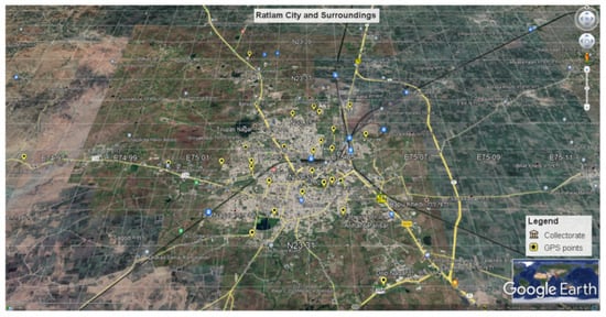
Figure 1.
Ratlam city and surroundings overlaid with GCPs (smartphone A-GPS) on the Google Earth platform.
2.2. Ground Control Point (GCP) Collection
The study area was surveyed using a Vivo 1606 phone with the Mobile Topographer app, for the evaluation of DEMs. A survey was carried out for collecting GCPs at appropriate locations such as parks, streets, urban areas, open grounds, and rural outer areas of Ratlam city for utilization as the checkpoints for the DEMs. The points were collected in the World Geodetic System (WGS-84) datum. The flowchart in Figure 2 describes the methodology.
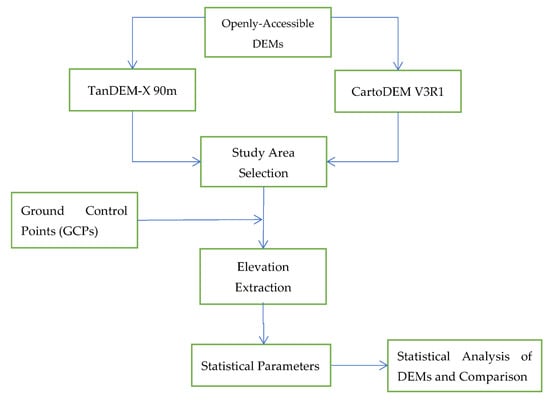
Figure 2.
Flow chart of the methodology for DEM evaluation using GCPs collected from A-GPS enabled Smartphone.
According to the researchers, coordinate accuracy can be achieved in the order of 1 m or better after 30 min of data collection using smartphone GPS [18]. In this study, the A-GPS smartphone data were collected as reference data for statistical analysis of DEMs and a minimum PDOP value of about 0.2 was attained in approximately 35 min of operations at desired GCP locations. Elevation data of TanDEM-X 90 and CartoDEM V3 R1 were extracted after superimposing the GCPs (Checkpoints) using ArcGIS as a standard method used in various studies for evaluation of DEMs [19,20]. Figure 3 displays a set of 30 GCPs obtained from a smartphone superimposed on DEMs.
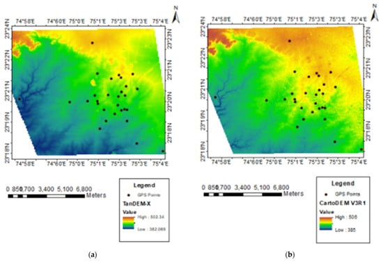
Figure 3.
Displays smartphone A-GPS points superimposed on (a) TanDEM-X 90 m; (b) CartoDEM V3 R1 DEMs.
2.3. Statistical Analysis
The elevation or height values extracted from both the DEMs were used to calculate the differences with DEMs. The accuracy estimation with smartphone A-GPS observation datasets is performed by calculating ME (Equation (1)), MAE (Equation (2)), and RMSE (Equation (3)) [21,22]. Hi(DEM) (=Hi(CartoDEM) or Hi(TanDEM-X)) is the extracted elevation from the DEMs dataset and Hi(A-GPS) is the A-GPS observed reference datasets at different GCP locations (i = 1 to n).
3. Results and Discussion
The difference between A-GPS reference elevation values and the openly accessible DEMs (TanDEM-X 90, and CartoDEM V3 R1) were evaluated as shown in Table 1 for analysis. The range of minimum and maximum values of TanDEM-X 90 using 30 GCPs in the study area is 11.09 and 17.83 m. Similarly, the values for CartoDEM V3R1 are 10.71 and 14.20 m, respectively. Table 2 indicates the results of statistical analysis between the two DEMs in the form of ME, MAE, and RMSE.

Table 1.
Statistical analysis of TanDEM 90 and CartoDEMV3R1 using Smartphone A-GPS (Sample set).
Table 2.
Statistical results of TanDEM-X 90m and CartoDEM V3R1.
The results revealed that the accuracy of CartoDEM V3 R1 is higher compared with TanDEM-X 90 in plain terrain regions of Ratlam city and surroundings. The elevation accuracy of DEM depends on the slope and land cover of the terrain, which allows the user to predict the DEM quality according to the terrain regions utilized as per the user’s requirements [8,23]. The difference between TanDEM-X 90, and CartoDEM V3 R1 elevation values is reasonable based on their methods of generation and thus may require more accurate methods for reference data generation such as DGPS or LiDAR datasets.
4. Conclusions
The GCPs were obtained with Vivo 1606 Smartphone A-GPS using Mobile Topographer app for successful experimentation, with an assessment of openly accessible DEMs. The DEM accuracy of the openly accessible DEMs using low-cost smartphones incorporated with A-GPS was computed reasonably, which serves applications meeting the accuracy requirement criterion. The methodology developed for the assessment of individual accuracies (35 min observation, PDOP~0.2) was well within the margins of the accuracy of an A-GPS Smartphone reference GCPs. The statistical result revealed that the accuracy of CartoDEM V3 R1 was higher compared to TanDEM-X 90, as found in similar studies [23]. However, the uncertainty in the analysis was governed by the accuracy of A-GPS and local site characteristics.
Author Contributions
Conceptualization, A.B.; methodology, A.B. and U.Y.; resources, U.Y.; data curation, U.Y. and A.B.; writing—original draft preparation, U.Y.; writing—review and editing, A.B. and U.Y. All authors have read and agreed to the published version of the manuscript.
Funding
This research received no external funding.
Institutional Review Board Statement
Not applicable.
Informed Consent Statement
Not applicable.
Data Availability Statement
Publicly available datasets were analyzed in this study. These data can be found here: https://bhuvan.nrsc.gov.in/home/index.php and https://download.geoservice.dlr.de/TDM90/ (accessed on 30 July 2021).
Acknowledgments
The authors would like to thank the Indian Space Research Organisation (ISRO), National Aeronautics and Space Administration (NASA), German Aerospace Center (DLR), and Google LLC for their immense support. The authors are highly indebted to the Director, IIRS, for his constant support and encouragement in conducting the research activities.
Conflicts of Interest
The authors declare no conflict of interest.
References
- Durmaz, A.I. Creating digital elevation model using a mobile device. ISPRS Ann. Photogramm. Remote Sens. Spat. Inf. Sci. 2017, 4, 203–207. [Google Scholar] [CrossRef]
- Venkateswarlu, E.; Raghuramulu, I.; Sivannarayana, T.; Swamy, G.P.; Krishna, B.G. Quality Evaluation of CartoDEM in Different Resolutions. In Proceedings of International Conference on Remote Sensing for Disaster Management; Springer: Berlin/Heidelberg, Germany, 2018; pp. 73–81. [Google Scholar] [CrossRef]
- Srivastava, P.K.; Srinivasan, T.P.; Gupta, A.; Singh, S.; Nain, J.S.; Prakash, S.; Kartikeyan, B.; Krishna, B.G. Recent advances in Cartosat-1 data processing. In The International Archives of the photogrammetry, Remote Sensing and Spatial Information Science; ISPRS Hannover Workshop; 2007; Volume XXXVI/1-W5, p. 10. Available online: https://www.isprs.org/proceedings/xxxvi/1-w51/paper/Srivastava_etal.pdf (accessed on 30 July 2021).
- Patel, A.; Katiyar, S.K.; Prasad, V. Performances evaluation of different open source DEM using Differential Global Positioning System (DGPS). Egypt. J. Remote Sens. Space Sci. 2016, 19, 7–16. [Google Scholar] [CrossRef]
- Kumar, V.; Bhardwaj, A.; Haldar, A.L. Assessment of vertical accuracy of open source dems in parts of gangetic plain region with ICESat data. In Proceedings of the 38th Asian Conference on Remote Sensing—Space Applications: Touching Human Lives, ACRS 2017, New Delhi, India, 23–27 October 2017. [Google Scholar]
- Khalid, N.F.; Din, A.H.M.; Omar, K.M.; Khanan, M.F.A.; Omar, A.H.; Hamid, A.I.A.; Pa’Suya, M.F. Open-source digital elevation model (dems) evaluation with gps and lidar data. Int. Arch. Photogramm. Remote Sens. Spat. Inf. Sci. 2016, 42, 299–306. [Google Scholar] [CrossRef]
- Sefercik, U.G. Comparison of DEM Accuracies Generated by Various Methods. In Proceedings of the 2007 3rd International Conference on Recent Advances in Space Technologies, Istanbul, Turkey, 14–16 June 2007; IEEE: Piscataway, NJ, USA, 2007; pp. 379–382. [Google Scholar] [CrossRef]
- Bhardwaj, A.; Jain, K.; Chatterjee, R.S. Generation of high-quality digital elevation models by assimilation of remote sensing-based DEMs. J. Appl. Remote Sens. 2019, 13, 044502. [Google Scholar] [CrossRef]
- Liu, Z.; Zhu, J.; Fu, H.; Zhou, C.; Zuo, T. Evaluation of the Vertical Accuracy of Open Global DEMs over Steep Terrain Regions Using ICESat Data: A Case Study over Hunan Province, China. Sensors 2020, 20, 4865. [Google Scholar] [CrossRef] [PubMed]
- Raghunath, S.; Malleswari, B.; Sridhar, K. Analysis of Gps Errors During Different Times in a Day. Int. J. Res. Comput. Sci. 2011, 2, 45–48. [Google Scholar] [CrossRef][Green Version]
- Sunda, S.; Sridharan, R.; Vyas, B.M.; Khekale, P.V.; Parikh, K.S.; Ganeshan, A.S.; Sudhir, C.R.; Satish, S.V.; Bagiya, M.S. Satellite-based augmentation systems: A novel and cost-effective tool for ionospheric and space weather studies. Space Weather 2014, 13, 6–15. [Google Scholar] [CrossRef]
- Gianniou, M.; Mitropoulou, E. Impact of High Ionospheric Activity on GPS Surveying: Experiences from the Hellenic RTK-Network during 2011–2012. EUREF Annual Symposium. 2012. Available online: www.sidc.be(http://www.euref.eu/symposia/2012Paris/02-08-p-Gianniou.pdf (accessed on 30 July 2021).
- Merry, K.; Bettinger, P. Smartphone GPS accuracy study in an urban environment. PLoS ONE 2019, 14, e0219890. [Google Scholar] [CrossRef] [PubMed]
- Dabove, P.; Di Pietra, V.; Piras, M. GNSS Positioning Using Mobile Devices with the Android Operating System. ISPRS Int. J. Geo-Inf. 2020, 9, 220. [Google Scholar] [CrossRef]
- Shinghal, G.; Bisnath, S. Conditioning and PPP processing of smartphone GNSS measurements in realistic environments. Satell. Navig. 2021, 2, 1–17. [Google Scholar] [CrossRef] [PubMed]
- Applicality. How to Use Mobile Topographer. 2021. Available online: http://applicality.com/how-to-use-mobile-topographer-free/ (accessed on 5 August 2021).
- Guo, L.; Wang, F.; Sang, J.; Lin, X.; Gong, X.; Zhang, W. Characteristics Analysis of Raw Multi-GNSS Measurement from Xiaomi Mi 8 and Positioning Performance Improvement with L5/E5 Frequency in an Urban Environment. Remote Sens. 2020, 12, 744. [Google Scholar] [CrossRef]
- Paziewski, J.; Sieradzki, R.; Baryla, R. Signal characterization and assessment of code GNSS positioning with low-power consumption smartphones. GPS Solut. 2019, 23, 1–12. [Google Scholar] [CrossRef]
- Gajalakshmi, K.; Anantharama, V. Comparative Study of Cartosat-DEM and SRTM-DEM on Elevation Data and Terrain Elements. Int. J. Adv. Remote Sens. GIS 2015, 4, 1361–1366. [Google Scholar] [CrossRef]
- Saini, O.; Bhardwaj, A.; Chatterjee, R.S. Generation of Radargrammetric Digital Elevation Model (DEM) and Vertical Accuracy Assessment using ICESat-2 Laser Altimetric Data and Available Open-Source DEMs. In Proceedings of the 39th INCA International Congress on New Age Cartography and Geospatial Technology in Digital India, Dehradun, India, 18–20 December 2019; p. 12. [Google Scholar]
- Willmott, C.; Matsuura, K. Advantages of the mean absolute error (MAE) over the root mean square error (RMSE) in assessing average model performance. Clim. Res. 2005, 30, 79–82. [Google Scholar] [CrossRef]
- Chai, T.; Draxler, R.R. Root mean square error (RMSE) or mean absolute error (MAE)?—Arguments against avoiding RMSE in the literature. Geosci. Model Dev. 2014, 7, 1247–1250. [Google Scholar] [CrossRef]
- Bhardwaj, A. Assessment of Vertical Accuracy for TanDEM-X 90 m DEMs in Plain, Moderate, and Rugged Terrain. Proceedings 2019, 24, 8. [Google Scholar] [CrossRef]


Publisher’s Note: MDPI stays neutral with regard to jurisdictional claims in published maps and institutional affiliations. |
© 2021 by the authors. Licensee MDPI, Basel, Switzerland. This article is an open access article distributed under the terms and conditions of the Creative Commons Attribution (CC BY) license (https://creativecommons.org/licenses/by/4.0/).