
Mapping Sub-Metre 3D Land-Sea Coral Reefscapes Using Superspectral WorldView-3 Satellite Stereoimagery


Abstract
:
1. Introduction
2. Materials and Methods
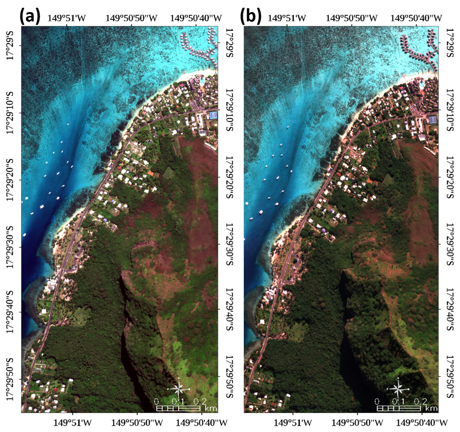
2.1. Study Site
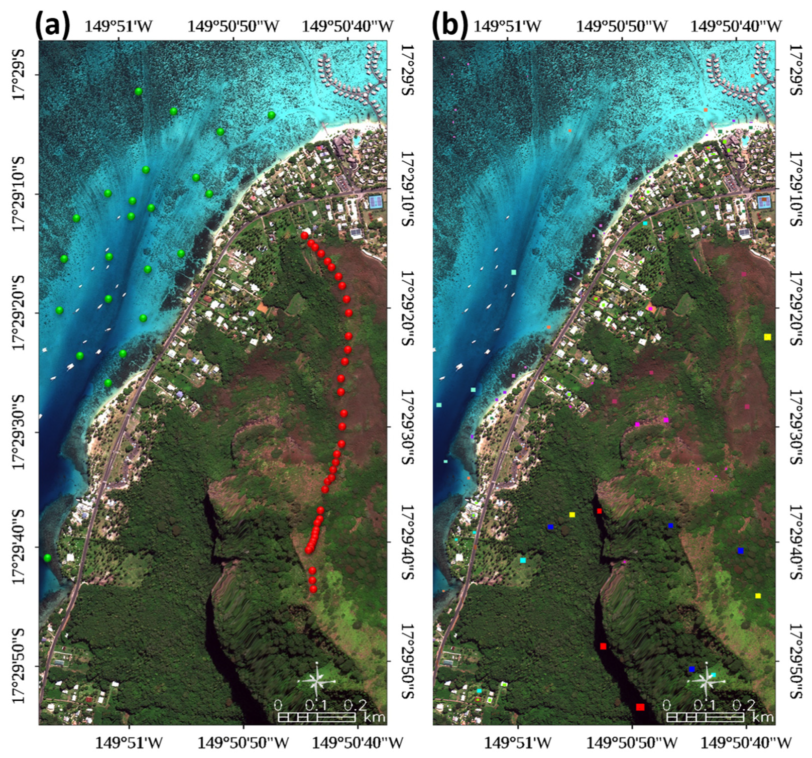
2.2. Land-, Sea- and Air-Truth Data
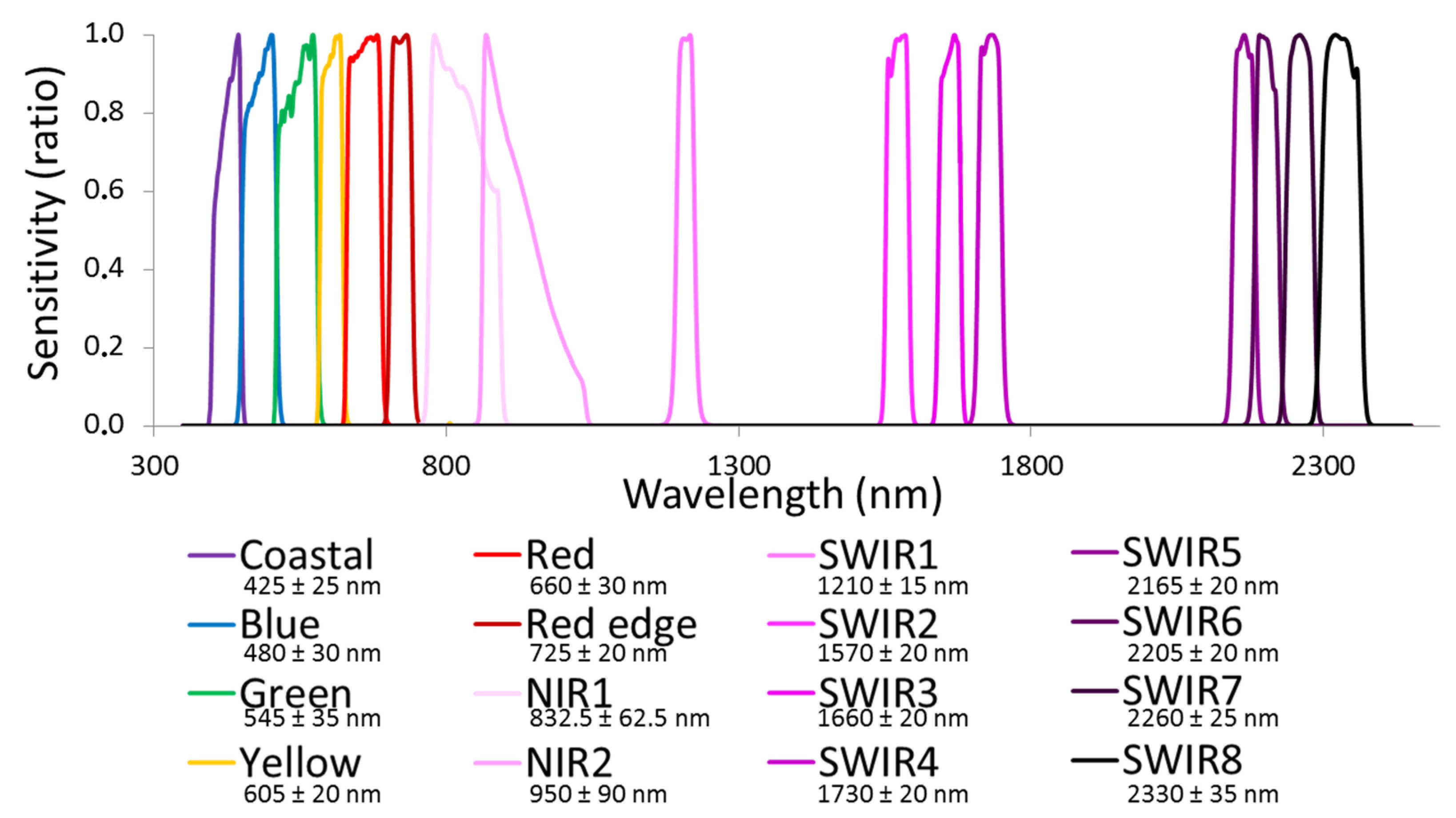
2.3. Spaceborne Dataset
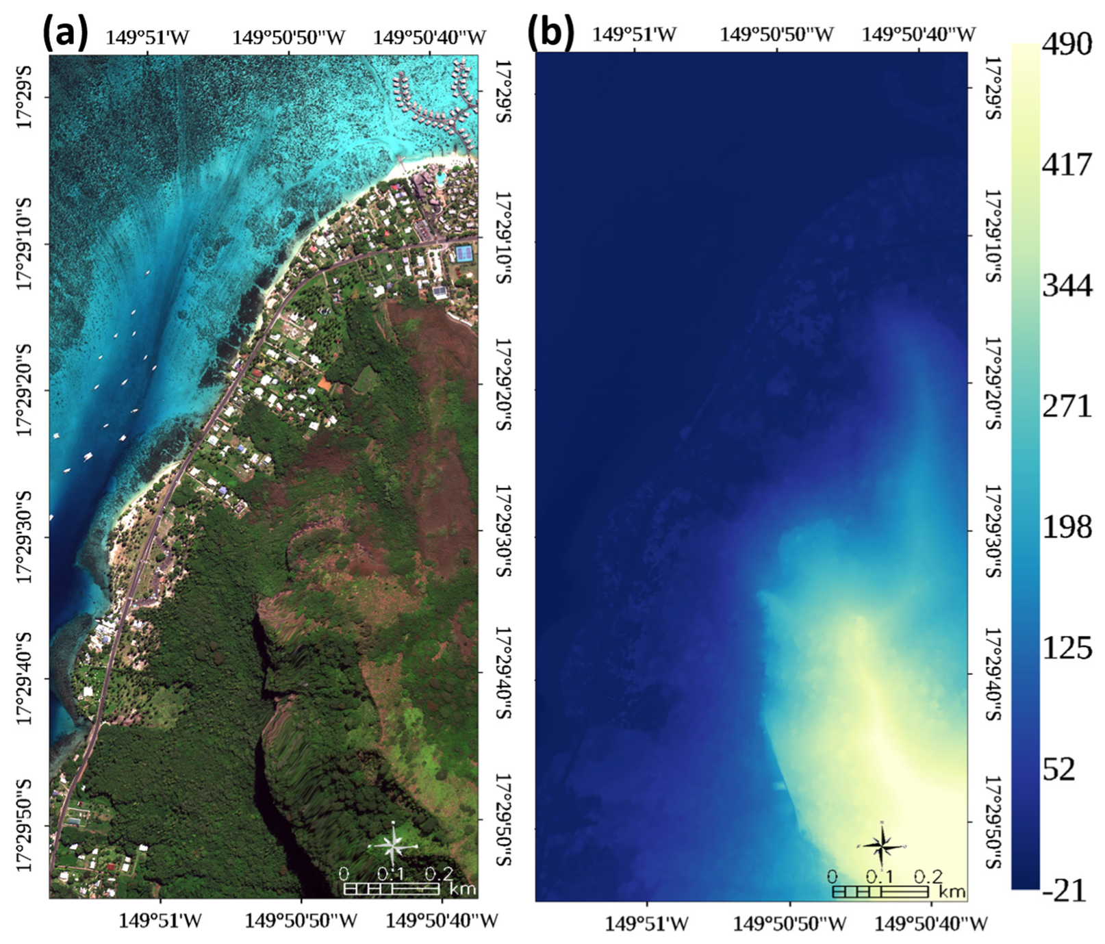
2.4. Spaceborne Topographic DSM
2.5. Spaceborne Bathymetric DSM
2.6. Habitat Classification
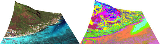
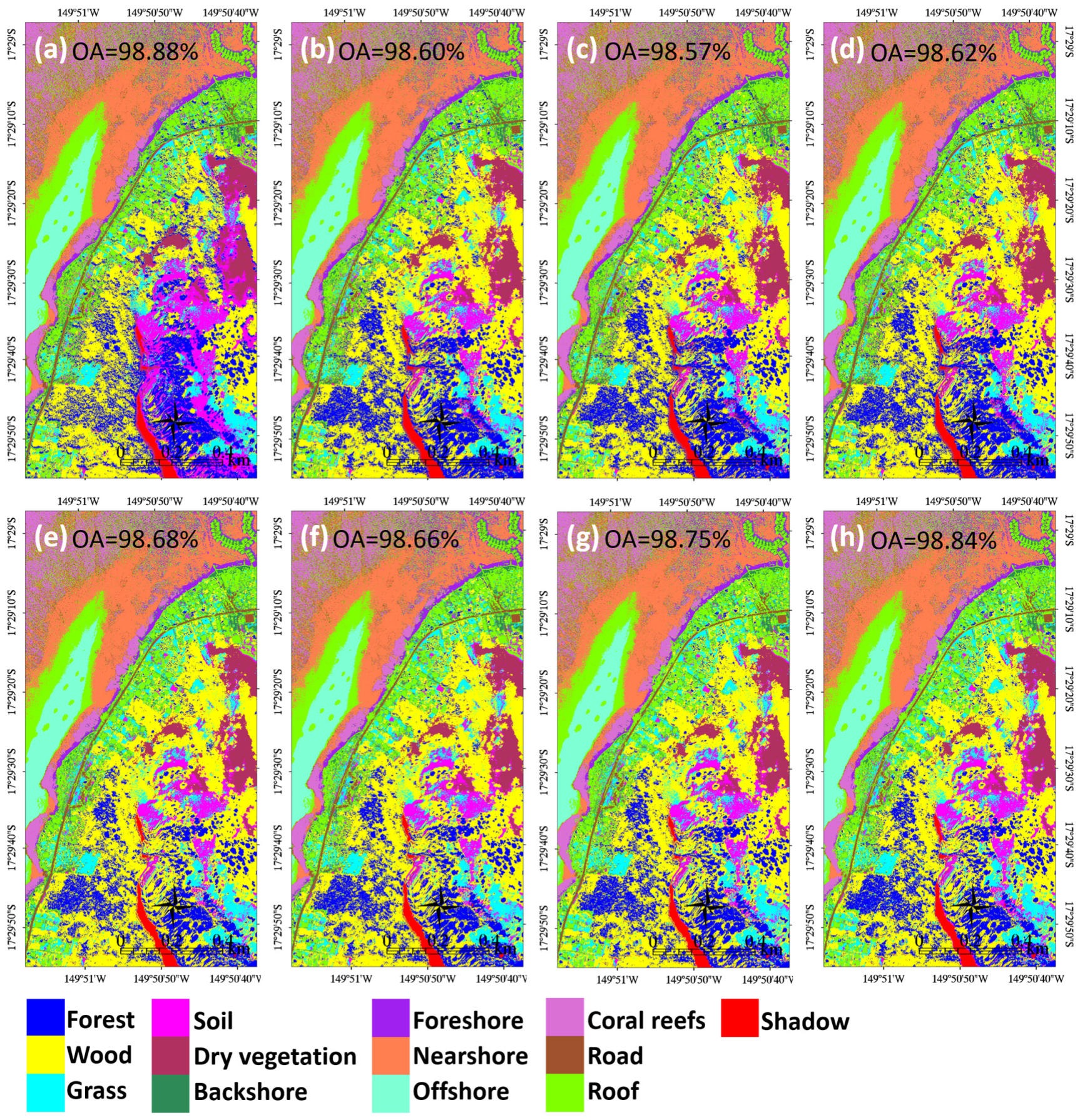
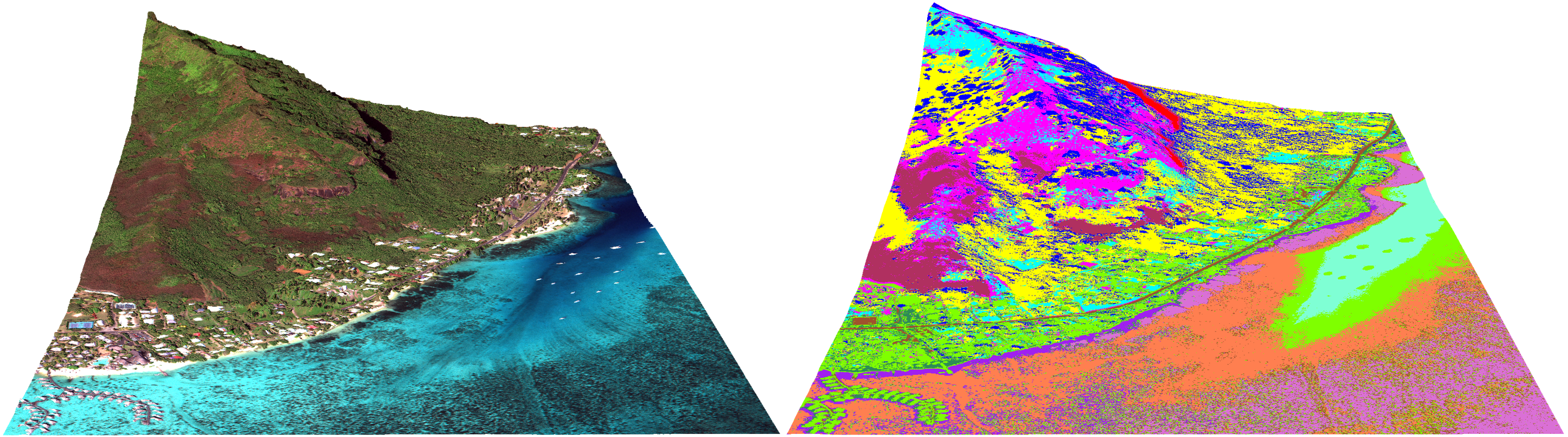
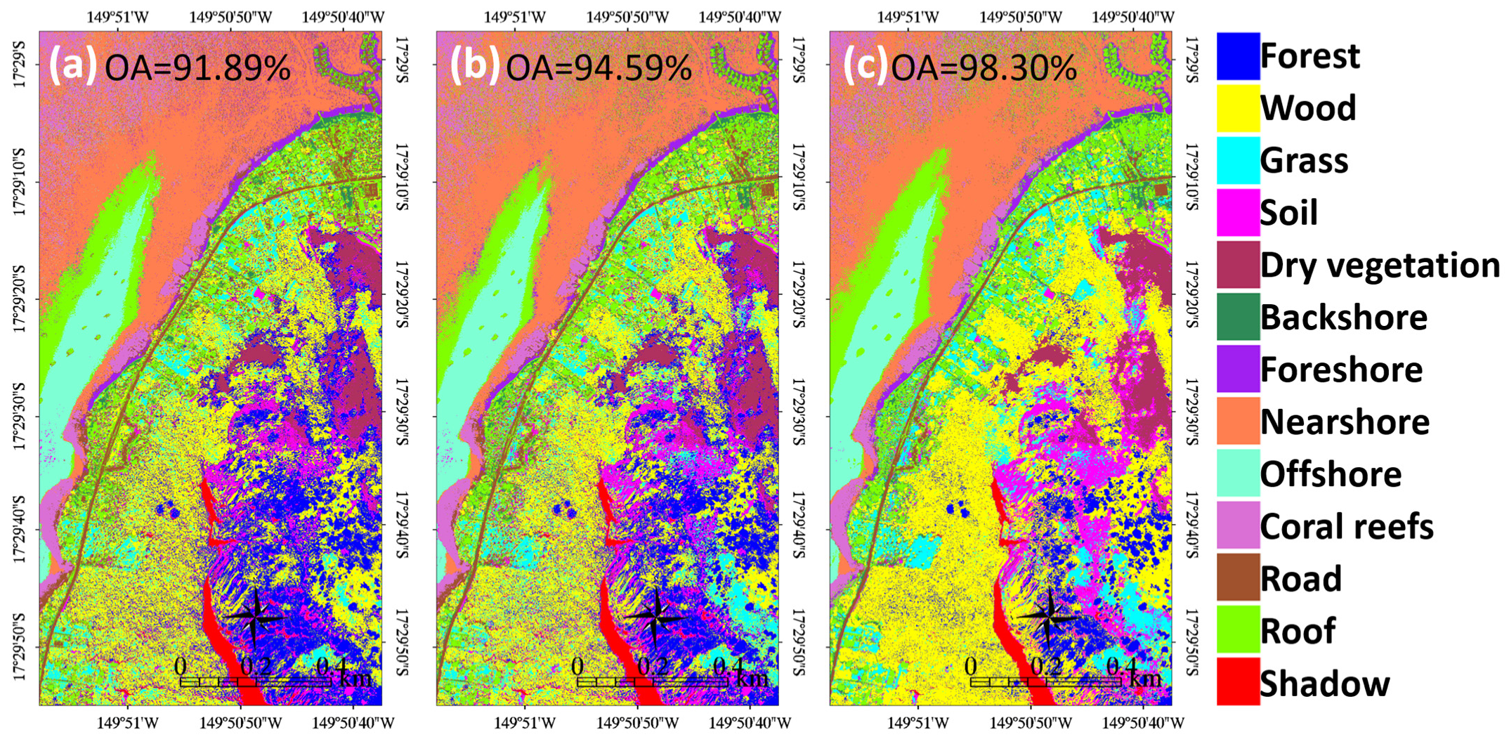
3. Results
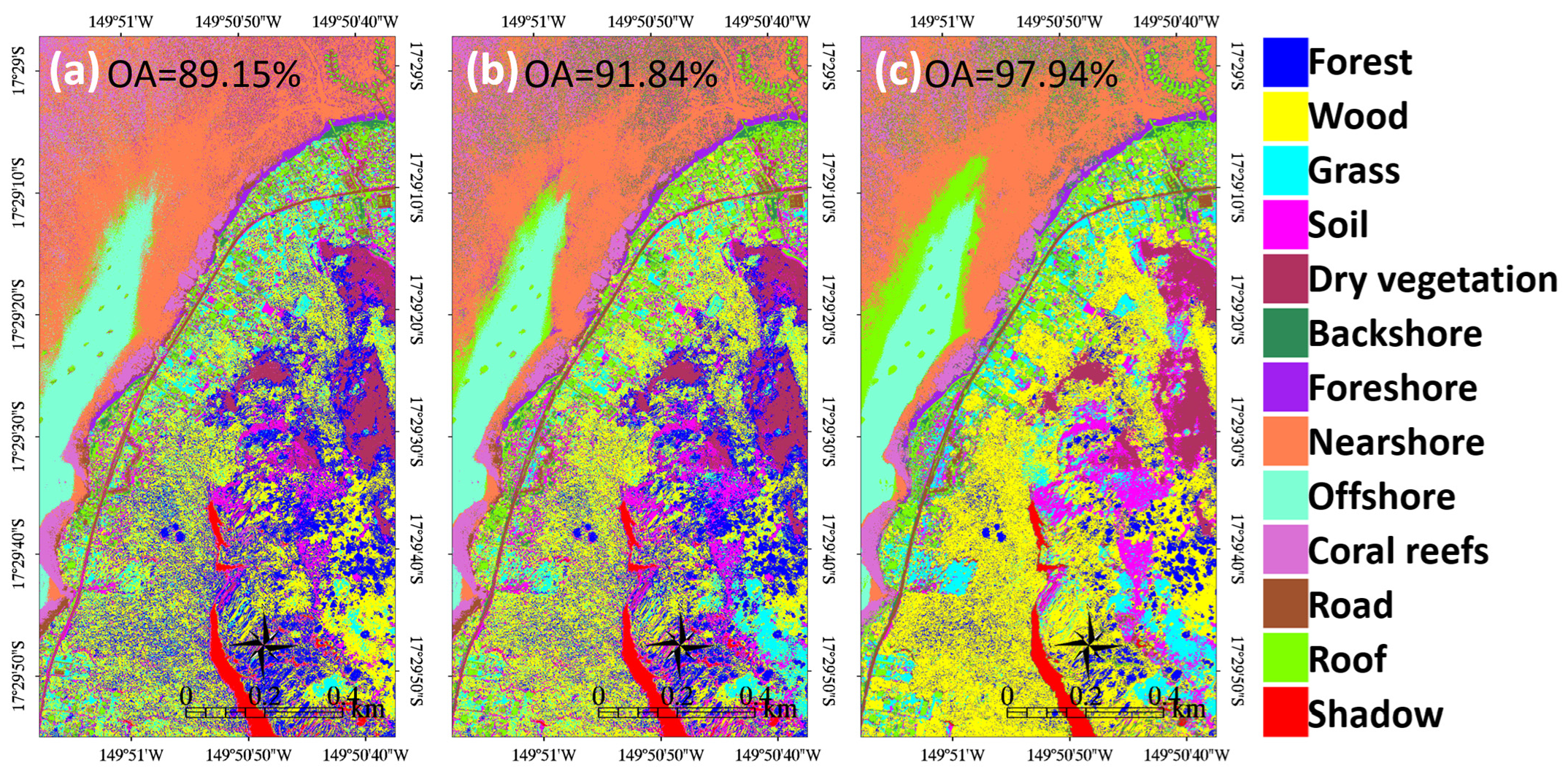
3.1. WorldView-3 Superspectral Land-Sea Habitat Mapping
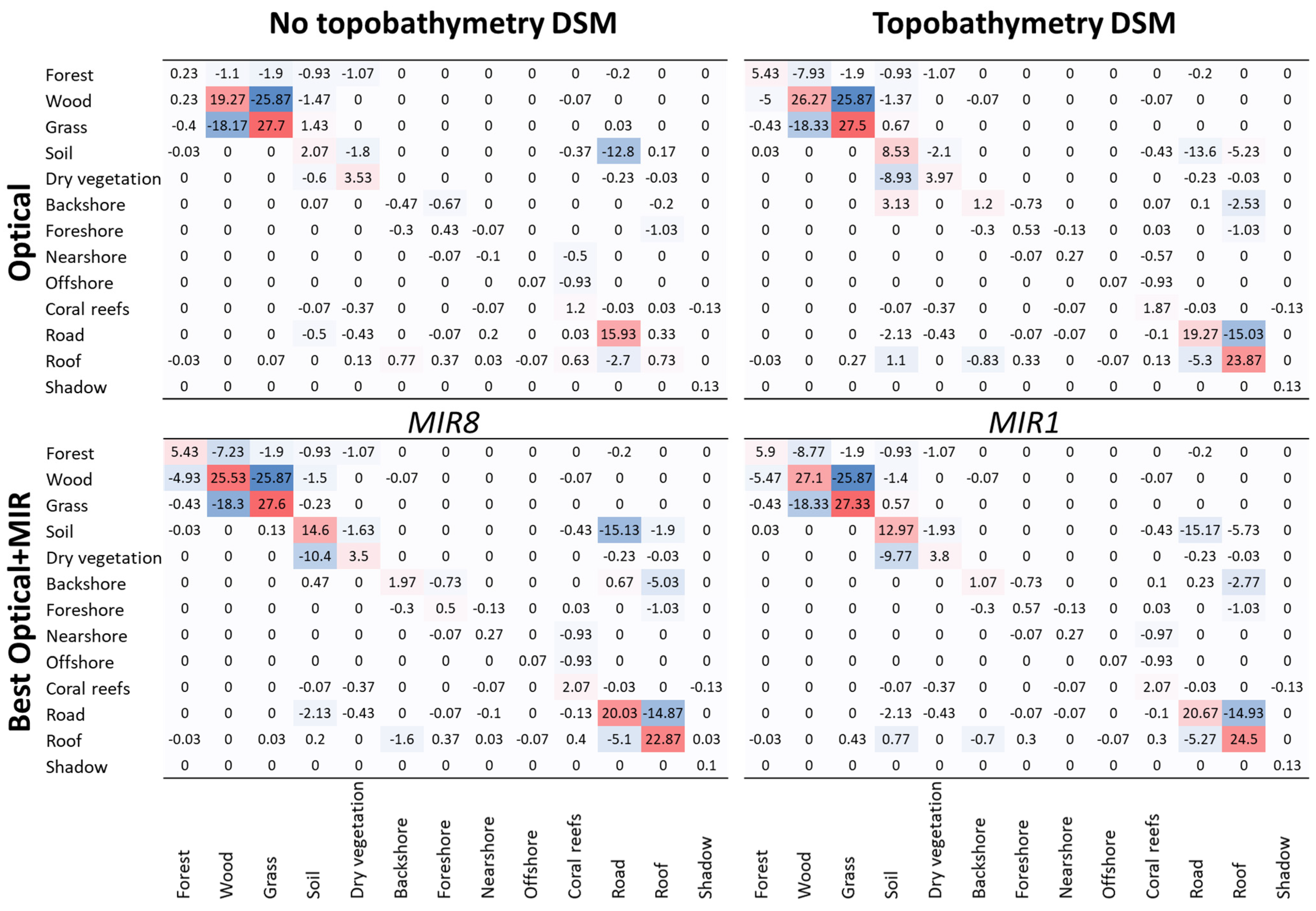
3.2. WorldView-3 Topobathymetry into Land-Sea Habitat Mapping
3.3. WorldView-3 Land-Sea Habitat Mapping at the Class Scale
4. Discussion
4.1. Land-Sea Coral Reefscape Mapping with a Multispectral WorldView-3 Stereo-Imagery
- To the basic BGR neared the sole VIS performance (≈2.7%);
- To the VIS prediction equaled 2.7%;
- To the optical accuracy approximated 6.4%.
4.2. Land-Sea Coral Reefscape Mapping with a Superspectral WorldView-3 Stereo-Imagery
- 0.94% with MIR1;
- 0.90% with MIR8;
- 0.63% with MIR3.
4.3. Land-Sea Coral Reefscape Mapping at the Class Scale
5. Conclusions
Author Contributions
Funding
Conflicts of Interest
References
- Costanza, R.; De Groot, R.; Sutton, P.; van der Ploeg, S.; Anderson, S.J.; Kubiszewski, I.; Farber, S.; Turner, R.K. Changes in the global value of ecosystem services. Glob. Environ. Chang. 2014, 26, 152–158. [Google Scholar] [CrossRef]
- Spalding, M.; Burke, L.; Wood, S.A.; Ashpole, J.; Hutchison, J.; zu Ermgassen, P. Mapping the global value and distribution of coral reef tourism. Mar. Policy 2017, 82, 104–113. [Google Scholar] [CrossRef]
- Spalding, M.; Spalding, M.D.; Ravilious, C.; Green, E.P. World Atlas of Coral Reefs; UNEP-WCMC: Cambridge, UK, 2001. [Google Scholar]
- Hughes, T.P.; Barnes, M.L.; Bellwood, D.R.; Cinner, J.E.; Cumming, G.S.; Jackson, J.B.; Kleypas, J.; Van De Leemput, I.A.; Lough, J.M.; Morrison, T.H.; et al. Coral reefs in the Anthropocene. Nature 2017, 546, 82–90. [Google Scholar] [CrossRef] [PubMed]
- Collin, A.; Hench, J.L. Towards Deeper Measurements of Tropical Reefscape Structure Using the WorldView-2 Spaceborne Sensor. Remote Sens. 2012, 4, 1425–1447. [Google Scholar] [CrossRef] [Green Version]
- Mancini, F.; Dubbini, M.; Gattelli, M.; Stecchi, F.; Fabbri, S.; Gabbianelli, G. Using Unmanned Aerial Vehicles (UAV) for High-Resolution Reconstruction of Topography: The Structure from Motion Approach on Coastal Environments. Remote Sens. 2013, 5, 6880–6898. [Google Scholar] [CrossRef] [Green Version]
- Agrafiotis, P.; Karantzalos, K.; Georgopoulos, A.; Skarlatos, D. Correcting Image Refraction: Towards Accurate Aerial Image-Based Bathymetry Mapping in Shallow Waters. Remote Sens. 2020, 12, 322. [Google Scholar] [CrossRef] [Green Version]
- Collin, A.M.; Andel, M.; James, D.; Claudet, J. The Superspectral/Hyperspatial Worldview-3 as The Link between Spaceborne Hyperspectral and Airborne Hyperspatial Sensors: The Case Study of the Complex Tropical Coast. Int. Arch. Photogramm. Remote Sens. Spat. Inf. Sci. 2019, XLII-2/W13, 1849–1854. [Google Scholar] [CrossRef] [Green Version]
- Collin, A.; Long, B.; Archambault, P. Merging land-marine realms: Spatial patterns of seamless coastal habitats using a multispectral LiDAR. Remote Sens. Environ. 2012, 123, 390–399. [Google Scholar] [CrossRef]
- Mury, A.; Collin, A.; James, D. Morpho–Sedimentary Monitoring in a Coastal Area, from 1D to 2.5D, Using Airborne Drone Imagery. Drones 2019, 3, 62. [Google Scholar] [CrossRef] [Green Version]
- Collin, A.; Archambault, P.; Planes, S. Bridging Ridge-to-Reef Patches: Seamless Classification of the Coast Using Very High Resolution Satellite. Remote Sens. 2013, 5, 3583–3610. [Google Scholar] [CrossRef] [Green Version]
- James, D.; Collin, A.; Mury, A.; Costa, S. Very high resolution land use and land cover mapping using pleiades-1 stereo imagery and machine learning. Int. Arch. Photogramm. Remote Sens. Spat. Inf. Sci. 2020, XLIII-B2-2, 675–682. [Google Scholar] [CrossRef]
- Collin, A.; Planes, S. Enhancing Coral Health Detection Using Spectral Diversity Indices from WorldView-2 Imagery and Machine Learners. Remote Sens. 2012, 4, 3244–3264. [Google Scholar] [CrossRef] [Green Version]
- Collin, A.; Hench, J.L.; Planes, S. A novel spaceborne proxy for mapping coral cover. In Proceedings of the 12th International Coral Reef Symposium, Cairns, Australia, 9–13 July 2012. [Google Scholar]
- Collin, A.; Etienne, S.; Feunteun, E. VHR coastal bathymetry using WorldView-3: Colour versus learner. Remote Sens. Lett. 2017, 8, 1072–1081. [Google Scholar] [CrossRef]
- Kruse, F.A.; Baugh, W.M.; Perry, S.L. Validation of DigitalGlobe WorldView-3 Earth imaging satellite shortwave infrared bands for mineral mapping. J. Appl. Remote Sens. 2015, 9, 96044. [Google Scholar] [CrossRef]
- Asadzadeh, S.; Filho, C.R.D.S. Investigating the capability of WorldView-3 superspectral data for direct hydrocarbon detection. Remote Sens. Environ. 2016, 173, 162–173. [Google Scholar] [CrossRef]
- Ye, B.; Tian, S.; Ge, J.; Sun, Y. Assessment of WorldView-3 Data for Lithological Mapping. Remote Sens. 2017, 9, 1132. [Google Scholar] [CrossRef]
- Collin, A.; Lambert, N.; Etienne, S. Satellite-based salt marsh elevation, vegetation height, and species composition mapping using the superspectral WorldView-3 imagery. Int. J. Remote Sens. 2018, 39, 5619–5637. [Google Scholar] [CrossRef]
- Ferreira, M.P.; Wagner, F.H.; Aragão, L.E.; Shimabukuro, Y.E.; Filho, C.R.D.S. Tree species classification in tropical forests using visible to shortwave infrared WorldView-3 images and texture analysis. ISPRS J. Photogramm. Remote Sens. 2019, 149, 119–131. [Google Scholar] [CrossRef]
- Guo, X.; Li, P. Mapping plastic materials in an urban area: Development of the normalized difference plastic index using WorldView-3 superspectral data. ISPRS J. Photogramm. Remote Sens. 2020, 169, 214–226. [Google Scholar] [CrossRef]
- Collin, A.; Hench, J.L.; Pastol, Y.; Planes, S.; Thiault, L.; Schmitt, R.J.; Holbrook, S.J.; Davies, N.; Troyer, M. High resolution topobathymetry using a Pleiades-1 triplet: Moorea Island in 3D. Remote Sens. Environ. 2018, 208, 109–119. [Google Scholar] [CrossRef]
- Collin, A.; Nadaoka, K.; Nakamura, T. Mapping VHR Water Depth, Seabed and Land Cover Using Google Earth Data. ISPRS Int. J. Geo Inform. 2014, 3, 1157–1179. [Google Scholar] [CrossRef] [Green Version]
- Collin, A.; Andel., M.; Lecchini, D.; Claudet, J. Submeter 3D ridge-to-reef classification using a WorldView-3 satellite stereoimagery. In Proceedings of the 14th International Coral Reef Symposium, Bremen, Germany, 5–10 July 2020. [Google Scholar]
- Davies, N.; IDEA Consortium; Field, D.; Gavaghan, D.; Holbrook, S.J.; Planes, S.; Troyer, M.; Bonsall, M.; Claudet, J.; Roderick, G.; et al. Simulating social-ecological systems: The Island Digital Ecosystem Avatars (IDEA) consortium. GigaScience 2016, 5, 14. [Google Scholar] [CrossRef] [Green Version]
- Institut de la Statistique de Polynesie Française. Le Recensement de la Population en Polynésie Française en 2017; ISPF: Papeete, French Polynesia, 2018. [Google Scholar]
- Kwan, C.; Budavari, B.; Bovik, A.C.; Marchisio, G. Blind Quality Assessment of Fused WorldView-3 Images by Using the Combinations of Pansharpening and Hypersharpening Paradigms. IEEE Geosci. Remote Sens. Lett. 2017, 14, 1835–1839. [Google Scholar] [CrossRef]
- Xu, F.; Woodhouse, N.; Xu, Z.; Marr, D.; Yang, X.; Wang, Y. Blunder elimination techniques in adaptive automatic terrain extraction. ISPRS J. 2008, 29, 21. [Google Scholar]
- Stumpf, R.P.; Holderied, K.; Sinclair, M. Determination of water depth with high-resolution satellite imagery over variable bottom types. Limnol. Oceanogr. 2003, 48, 547–556. [Google Scholar] [CrossRef]
- Baldridge, A.; Hook, S.; Grove, C.; Rivera, G. The ASTER spectral library version 2.0. Remote Sens. Environ. 2009, 113, 711–715. [Google Scholar] [CrossRef]


| Class Name | Class Description | Class Colour |
|---|---|---|
| Forest | Wet arborescent stratum |  |
| Wood | Wet arbustive stratum |  |
| Grass | Wet herbaceous stratum |  |
| Dry vegetation | Wind and sun exposed forest, wood or grass |  |
| Soil | Bare volcanic or lateritic substratum |  |
| Roof | Wooden or metallic house covering |  |
| Road | Tarmac way |  |
| Shadow | Tree or house shading |  |
| Backshore | Emerged coral sand |  |
| Foreshore | Shallow coral sand |  |
| Nearshore | Mid coral sand |  |
| Offshore | Deep coral sand |  |
| Coral reefs | Scleractinian and coralline algae |  |
| Parameters | Imagery #1 | Imagery #2 |
|---|---|---|
| Date | 12 July 2018 | 12 July 2018 |
| Time (UTC) | 20:35:38 | 20:36:39 |
| Mean viewing angle | ||
| In-track (in °) | 23.6 | −12.6 |
| Cross-track (in °) | 12.2 | 10.8 |
| Off-nadir (in °) | 26.4 | 16.5 |
| Satellite azimuth (in °) | 34.3 | 148.6 |
| Satellite elevation (in °) | 60.7 | 71.9 |
| Sun azimuth (in °) | 29.9 | 29.7 |
| Sun elevation (in °) | 45.0 | 45.1 |
Publisher’s Note: MDPI stays neutral with regard to jurisdictional claims in published maps and institutional affiliations. |
© 2021 by the authors. Licensee MDPI, Basel, Switzerland. This article is an open access article distributed under the terms and conditions of the Creative Commons Attribution (CC BY) license (https://creativecommons.org/licenses/by/4.0/).
Share and Cite
Collin, A.; Andel, M.; Lecchini, D.; Claudet, J. Mapping Sub-Metre 3D Land-Sea Coral Reefscapes Using Superspectral WorldView-3 Satellite Stereoimagery. Oceans 2021, 2, 315-329. https://doi.org/10.3390/oceans2020018
Collin A, Andel M, Lecchini D, Claudet J. Mapping Sub-Metre 3D Land-Sea Coral Reefscapes Using Superspectral WorldView-3 Satellite Stereoimagery. Oceans. 2021; 2(2):315-329. https://doi.org/10.3390/oceans2020018
Chicago/Turabian StyleCollin, Antoine, Mark Andel, David Lecchini, and Joachim Claudet. 2021. "Mapping Sub-Metre 3D Land-Sea Coral Reefscapes Using Superspectral WorldView-3 Satellite Stereoimagery" Oceans 2, no. 2: 315-329. https://doi.org/10.3390/oceans2020018
APA StyleCollin, A., Andel, M., Lecchini, D., & Claudet, J. (2021). Mapping Sub-Metre 3D Land-Sea Coral Reefscapes Using Superspectral WorldView-3 Satellite Stereoimagery. Oceans, 2(2), 315-329. https://doi.org/10.3390/oceans2020018