When Land Use/Land Cover Misleads: Limitations in Data-Driven Flood and Landslide Susceptibility Assessment
 ,
,  , and
, and
Abstract
1. Introduction
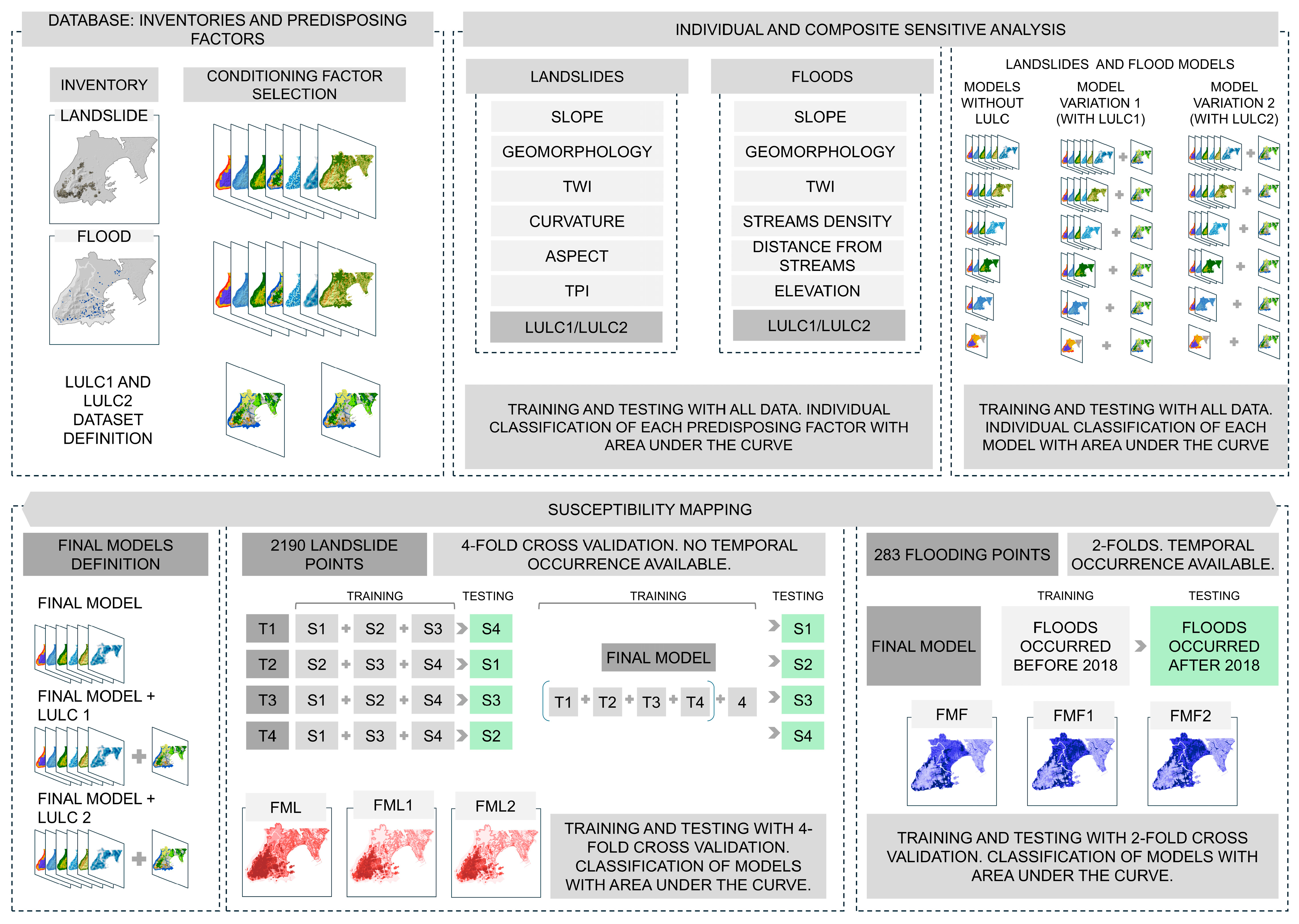
2. Data and Methods
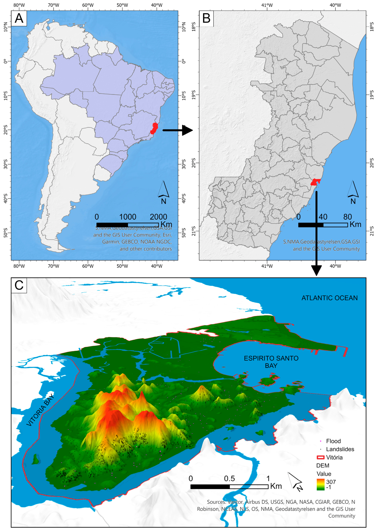
2.1. Study Area
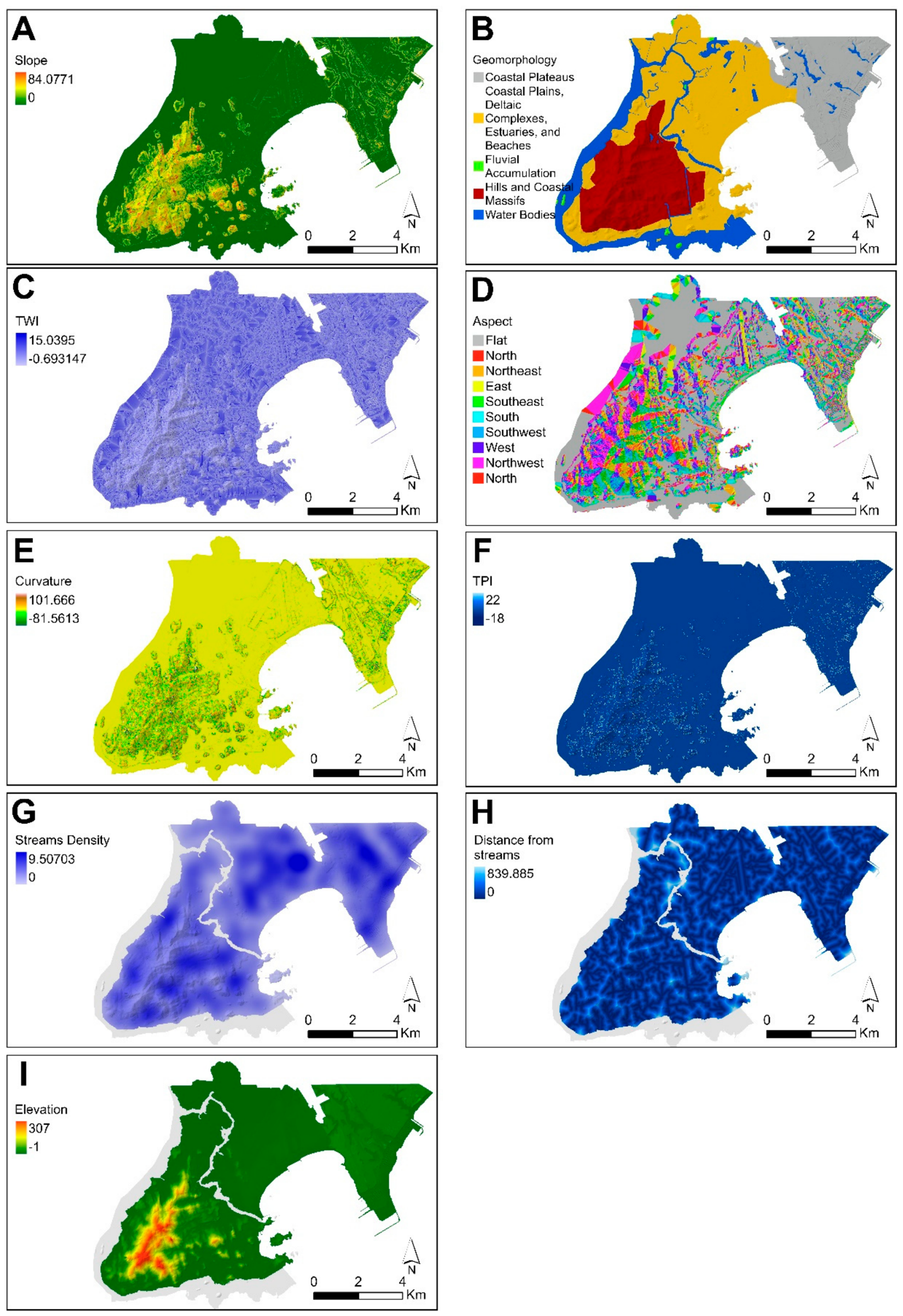
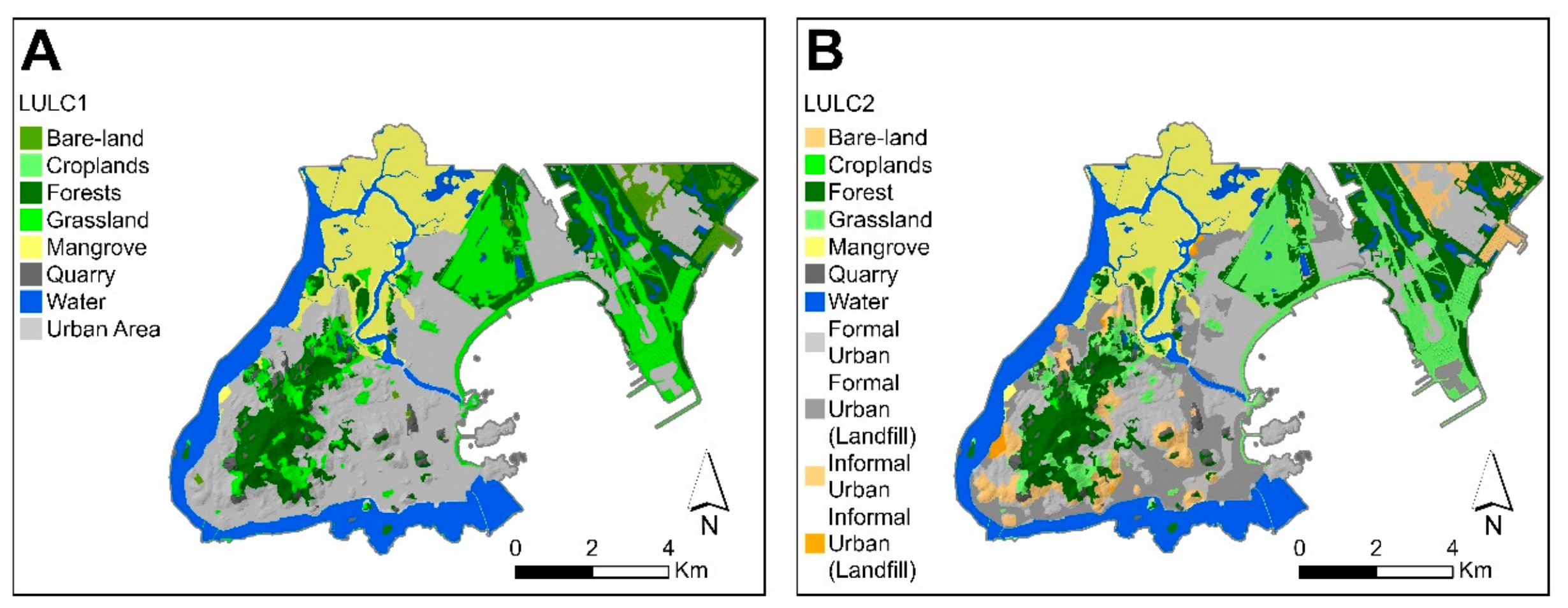
2.2. Database: Inventories and Predisposing Factors
2.3. Individual and Composite Sensitivity Analysis
2.4. Susceptibility Mapping with and Without LULC
3. Results
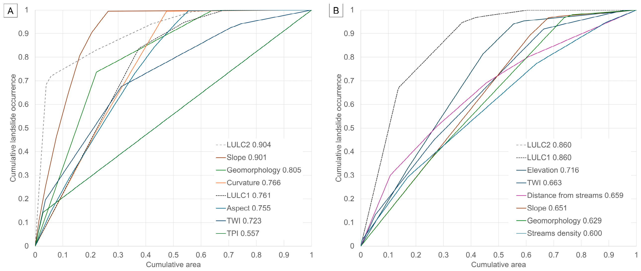
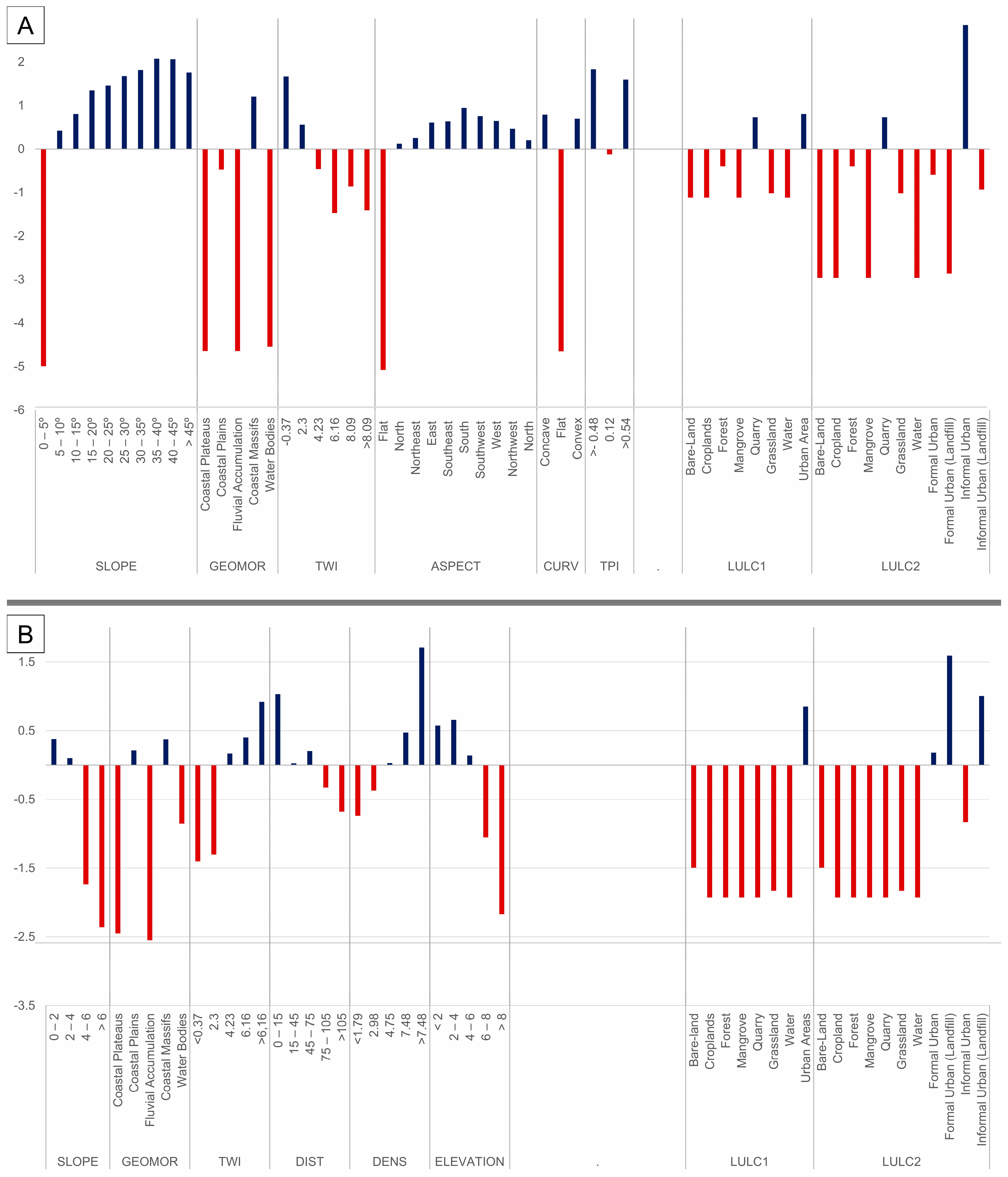
3.1. Individual and Composite Sensitivity Analysis
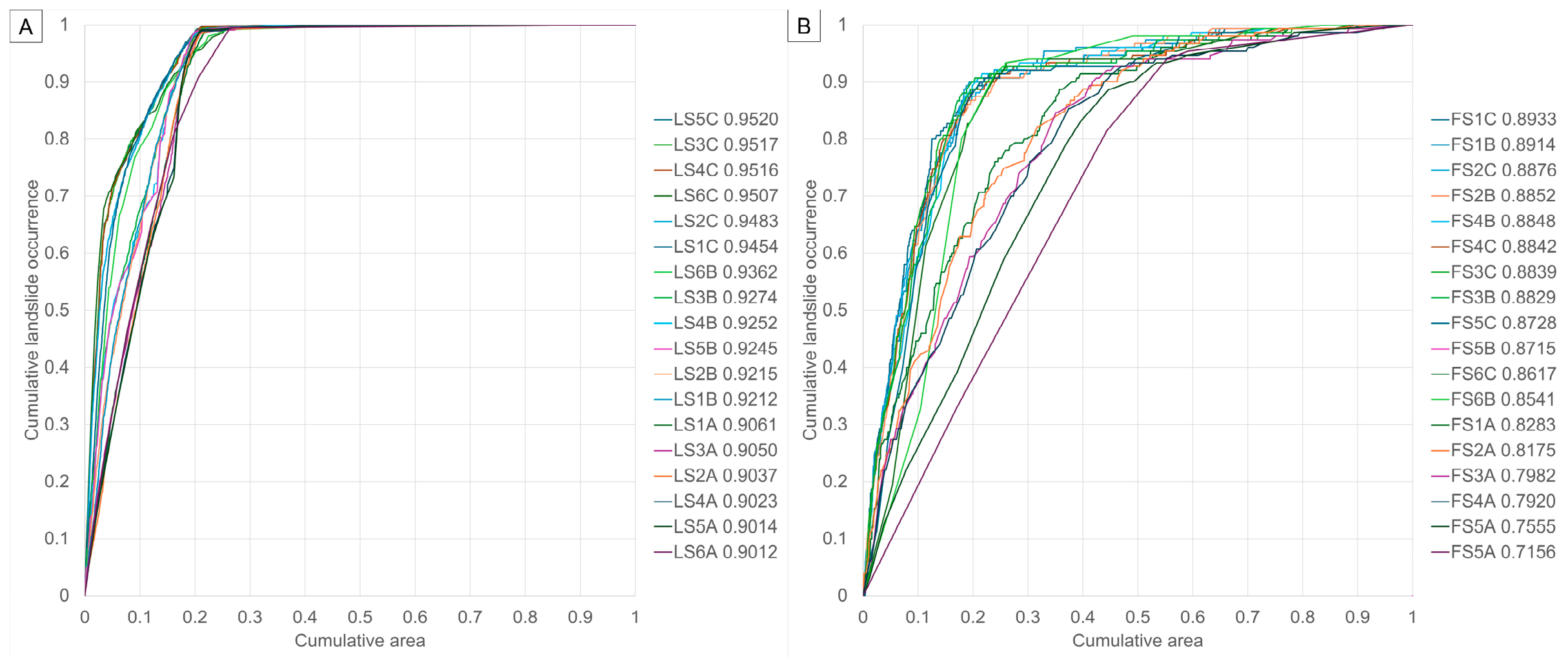
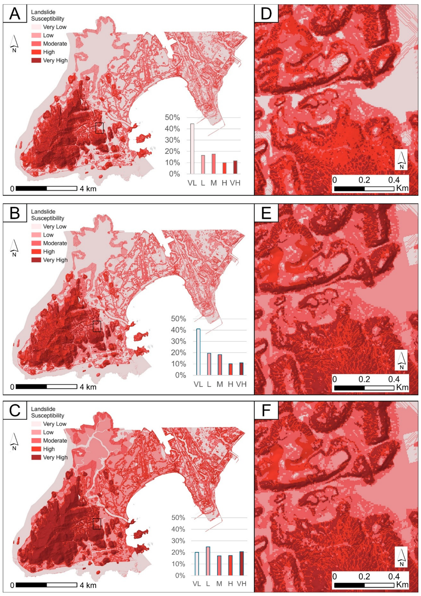
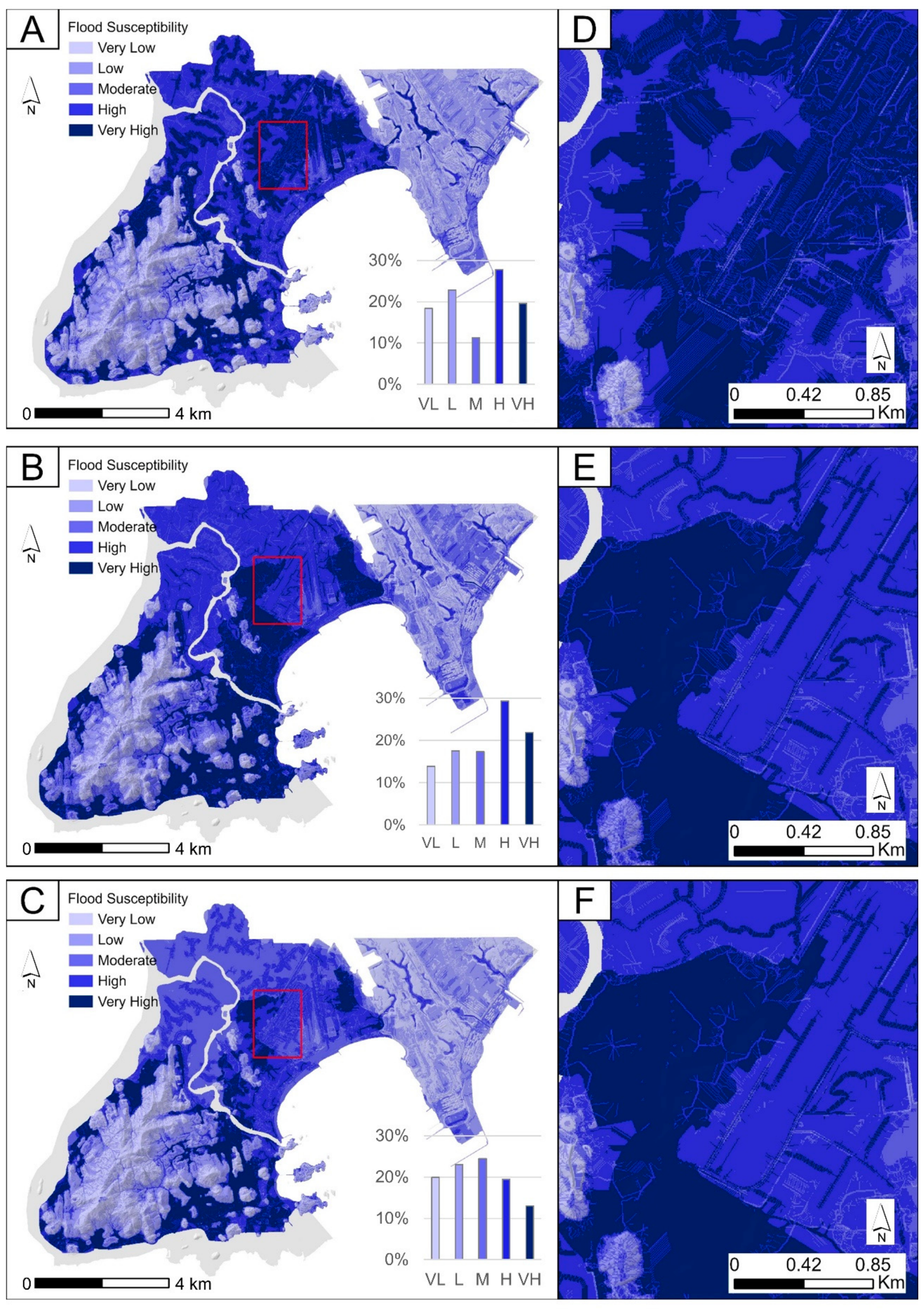
3.2. Susceptibility Models with and Without LULC
4. Discussion
4.1. Individual and Composite Sensitivity Analysis
4.2. Susceptibility Models with and Without LULC
5. Conclusions
Author Contributions
Funding
Data Availability Statement
Acknowledgments
Conflicts of Interest
Abbreviations
| AUC | Area Under the Curve |
| FMF | Final Model Flood |
| FML | Final Model Landslide |
| LULC | Land Use and Land Cover |
| LULC1 | Land Use and Land Cover with urban areas |
| LULC2 | Land Use and Land Cover with urban areas detailing |
| TPI | Topographic Position Index |
| TWI | Topographic Wetness Index |
References
- Budimir, M.; Trogrlić, R.Š.; Almeida, C.; Arestegui, M.; Vásquez, O.C.; Cisneros, A.; Iriarte, M.C.; Dia, A.; Lizon, L.; Madueño, G.; et al. Opportunities and challenges for people-centered multi-hazard early warning systems: Perspectives from the Global South. IScience 2025, 28, 112353. [Google Scholar] [CrossRef] [Scilit] [PubMed]
- Sandoval, V.; Sarmiento, J.P. A neglected issue: Informal settlements, urban development, and disaster risk reduction in Latin America and the Caribbean. Disaster Prev. Manag. Int. J. 2020, 29, 731–745. [Google Scholar] [CrossRef] [Scilit]
- UNDRR. Global Assessment Report on Disaster Risk Reduction; Imprimerie Centrale: Geneva, Switzerland, 2019. [Google Scholar]
- WBG; GFDRR. Building Resilience: Integrating Climate and Disaster Risk into Development; WBG: Washington, DC, USA, 2013. [Google Scholar]
- Lian, J.; Xu, H.; Xu, K.; Ma, C. Optimal management of the flooding risk caused by the joint occurrence of extreme rainfall and high tide level in a coastal city. Nat. Hazards 2017, 89, 183–200. [Google Scholar] [CrossRef] [Scilit]
- Pakati, S.S.; Shoko, C.; Dube, T. Integrated flood modelling and risk assessment in urban areas: A review on applications, strengths, limitations and future research directions. J. Hydrol. Reg. Stud. 2025, 61, 102583. [Google Scholar] [CrossRef] [Scilit]
- Yuan, J.; Zheng, F.; Duan, H.F.; Deng, Z.; Kapelan, Z.; Savic, D.; Shao, T.; Huang, W.-M.; Zhao, T.; Chen, X. Numerical modelling and quantification of coastal urban compound flooding. J. Hydrol. 2024, 630, 130716. [Google Scholar] [CrossRef] [Scilit]
- Skilodimou, H.D.; Bathrellos, G.D.; Chousianitis, K.; Youssef, A.M.; Pradhan, B. Multi-hazard assessment modeling via multi-criteria analysis and GIS: A case study. Environ. Earth Sci. 2019, 78, 47. [Google Scholar] [CrossRef] [Scilit]
- Guo, Z.; Moosavi, V.; Leitão, J.P. Data-driven rapid flood prediction mapping with catchment generalizability. J. Hydrol. 2022, 609, 127726. [Google Scholar] [CrossRef] [Scilit]
- Zêzere, J.L.; Pereira, S.; Melo, R.; Oliveira, S.C.; Garcia, R.A.C. Mapping landslide susceptibility using data-driven methods. Sci. Total Environ. 2017, 589, 250–267. [Google Scholar] [CrossRef] [Scilit] [PubMed]
- Addis, A. GIS—Based flood susceptibility mapping using frequency ratio and information value models in upper Abay river basin, Ethiopia. Nat. Hazards Res. 2023, 3, 247–256. [Google Scholar] [CrossRef] [Scilit]
- Marchesini, I.; Salvati, P.; Rossi, M.; Donnini, M.; Sterlacchini, S.; Guzzetti, F. Data-driven flood hazard zonation of Italy. J. Environ. Manag. 2021, 294, 112986. [Google Scholar] [CrossRef] [Scilit] [PubMed]
- Tariq, A.; Yan, J.; Ghaffar, B.; Qin, S.; Mousa, B.G.; Sharifi, A.; Huq, E.; Aslam, M. Flash Flood Susceptibility Assessment and Zonation by Integrating Analytic Hierarchy Process and Frequency Ratio Model with Diverse Spatial Data. Water 2022, 14, 3069. [Google Scholar] [CrossRef] [Scilit]
- Reichenbach, P.; Rossi, M.; Malamud, B.D.; Mihir, M.; Guzzetti, F. A review of statistically-based landslide susceptibility models. Earth Sci. Rev. 2018, 180, 60–91. [Google Scholar] [CrossRef] [Scilit]
- Barella, C.F.; Sobreira, F.G.; Zêzere, J.L. A comparative analysis of statistical landslide susceptibility mapping in the southeast region of Minas Gerais state, Brazil. Bull. Eng. Geol. Environ. 2019, 78, 3205–3221. [Google Scholar] [CrossRef] [Scilit]
- Kumar, A.; Sharma, R.K.; Bansal, V.K. GIS-based comparative study of information value and frequency ratio method for landslide hazard zonation in a part of mid-Himalaya in Himachal Pradesh. Innov. Infrastruct. Solut. 2019, 4, 28. [Google Scholar] [CrossRef] [Scilit]
- Liu, Y.; Meng, Z.; Zhu, L.; Hu, D.; He, H. Optimizing the Sample Selection of Machine Learning Models for Landslide Susceptibility Prediction Using Information Value Models in the Dabie Mountain Area of Anhui, China. Sustainability 2023, 15, 1971. [Google Scholar] [CrossRef] [Scilit]
- Wubalem, A.; Meten, M. Landslide susceptibility mapping using information value and logistic regression models in Goncha Siso Eneses area, northwestern Ethiopia. SN Appl. Sci. 2020, 2, 807. [Google Scholar] [CrossRef] [Scilit]
- Chowdhury, M.S. Flash flood susceptibility mapping of north-east depression of Bangladesh using different GIS based bivariate statistical models. Watershed Ecol. Environ. 2024, 6, 26–40. [Google Scholar] [CrossRef] [Scilit]
- Mind’je, R.; Li, L.; Kayumba, P.M.; Mupenzi, C.; Mindje, M.; Hao, J. Exploring a form of pixel-based information value model for flood probability assessment and geo-visualization over an East African basin: A case of Nyabarongo in Rwanda. Environ. Earth Sci. 2023, 82, 402. [Google Scholar] [CrossRef] [Scilit]
- Saha, S.; Sarkar, D.; Mondal, P. Efficiency exploration of frequency ratio, entropy and weights of evidence-information value models in flood vulnerabilityassessment: A study of raiganj subdivision, Eastern India. Stoch. Environ. Res. Risk Assess. 2022, 36, 1721–1742. [Google Scholar] [CrossRef] [Scilit]
- Seleem, O.; Ayzel, G.; Bronstert, A.; Heistermann, M. Transferability of data-driven models to predict urban pluvial flood water depth in Berlin, Germany. Nat. Hazards Earth Syst. Sci. 2023, 23, 809–822. [Google Scholar] [CrossRef] [Scilit]
- Sinčić, M.; Bernat Gazibara, S.; Rossi, M.; Mihalić Arbanas, S. Comparison of conditioning factor classification criteria in large-scale statistically based landslide susceptibility models. Nat. Hazards Earth Syst. Sci. 2025, 25, 183–206. [Google Scholar] [CrossRef] [Scilit]
- Quevedo, R.P.; Velastegui-Montoya, A.; Montalván-Burbano, N.; Morante-Carballo, F.; Korup, O.; Daleles Rennó, C. Land use and land cover as a conditioning factor in landslide susceptibility: A literature review. Landslides 2023, 20, 967–982. [Google Scholar] [CrossRef] [Scilit]
- Roy, D.; Aithal, B.H.; Dhar, A.; Desai, V.R. Impact of Land Use/Land Cover Change on Future Flash Flood Vulnerability and Monsoon Runoff in an Ungauged Himalayan Watershed. J. Hydrol. Eng. 2024, 29, 3. [Google Scholar] [CrossRef] [Scilit]
- Hassan, A.N.; Brahim, I.; Mustapha, N.; Kamal, E.B.; Youssef, B. Landslide susceptibility mapping by remote sensing and GIS using frequency ratio, value of information and logistic regression methods in the N’fis watershed, High Atlas of Marrakech (Morocco). Disaster Adv. 2024, 17, 31–47. [Google Scholar] [CrossRef] [Scilit]
- Zhao, F.; Miao, F.; Wu, Y.; Gong, S.; Zheng, G.; Yang, J.; Zhan, W. Landslide dynamic susceptibility mapping in urban expansion area considering spatiotemporal land use and land cover change. Sci. Total Environ. 2024, 949, 175059. [Google Scholar] [CrossRef] [Scilit] [PubMed]
- Reichenbach, P.; Busca, C.; Mondini, A.C.; Rossi, M. The Influence of Land Use Change on Landslide Susceptibility Zonation: The Briga Catchment Test Site (Messina, Italy). Environ. Manag. 2014, 54, 1372–1384. [Google Scholar] [CrossRef] [Scilit] [PubMed]
- Shu, H.; Hürlimann, M.; Molowny-Horas, R.; González, M.; Pinyol, J.; Abancó, C.; Ma, J. Relation between land cover and landslide susceptibility in Val d’Aran, Pyrenees (Spain): Historical aspects, present situation and forward prediction. Sci. Total Environ. 2019, 693, 133557. [Google Scholar] [CrossRef] [Scilit] [PubMed]
- Soliman, M.; Morsy, M.M.; Radwan, H.G. Assessment of Implementing Land Use/Land Cover LULC 2020-ESRI Global Maps in 2D Flood Modeling Application. Water 2022, 14, 3963. [Google Scholar] [CrossRef] [Scilit]
- Dell’Aira, F.; Meier, C.I. Beyond total impervious area: A new lumped descriptor of basin-wide hydrologic connectivity for characterizing urban watersheds. Hydrol. Earth Syst. Sci. 2025, 29, 1001–1032. [Google Scholar] [CrossRef] [Scilit]
- Nandam, V.; Patel, P.L. On the role of digital terrain topography and land use dynamics in flood hazard assessment of urban floodplain. Nat. Hazards 2024, 120, 11877–11902. [Google Scholar] [CrossRef] [Scilit]
- Nguyen, H.D.; Fox, D.; Dang, D.K.; Pham, L.T.; Viet Du, Q.V.; Nguyen, T.H.T.; Dang, T.N.; Tran, V.T.; Vu, P.L.; Nguyen, Q.-H.; et al. Predicting future urban flood risk using land change and hydraulic modeling in a river watershed in the central province of Vietnam. Remote Sens. 2021, 13, 262. [Google Scholar] [CrossRef] [Scilit]
- Rogger, M.; Agnoletti, M.; Alaoui, A.; Bathurst, J.C.; Bodner, G.; Borga, M.; Chaplot, V.; Gallart, F.; Glatzel, G.; Hall, J.; et al. Land use change impacts on floods at the catchment scale: Challenges and opportunities for future research. Water Resour. Res. 2017, 53, 5209–5219. [Google Scholar] [CrossRef] [Scilit] [PubMed]
- Aksoy, H. Determination of landslide susceptibility with Analytic Hierarchy Process (AHP) and the role of forest ecosystem services on landslide susceptibility. Environ. Monit. Assess. 2023, 195, 1525. [Google Scholar] [CrossRef] [Scilit] [PubMed]
- Aksoy, H. Flood Risk Analysis with AHP and the Role of Forests in Natural Flood Management: A Case Study from the North of Türkiye. Kastamonu Univ. J. For. Fac. 2023, 23, 282–297. [Google Scholar] [CrossRef] [Scilit]
- Tian, J.; Chen, Y.; Yang, L.; Li, D.; Liu, L.; Li, J.; Tang, X. Enhancing Urban Flood Susceptibility Assessment by Capturing the Features of the Urban Environment. Remote Sens. 2025, 17, 1347. [Google Scholar] [CrossRef] [Scilit]
- Ibrahim, A.; Wageeh, A.; Hamouda, M.A.; Ahmed, A.; Gad, A. Impact of LULC Classification Methods on Runoff Simulation in an Arid Mountainous Watershed Using Remote Sensing and Machine Learning. Earth 2026, 7, 26. [Google Scholar] [CrossRef] [Scilit]
- Pimentel, T.B.; Bricalli, L.L. A Relação entre os Padrões de Lineamentos e os Movimentos de Massa no Município de Vitória (Espírito Santo, Sudeste do Brasil). Soc. Nat. 2023, 35, 1. [Google Scholar] [CrossRef] [Scilit]
- Prefeitura Municipal de Vitória. Mapenco Web Mapeamento de Áreas de Risco Geológico-Geotécnico e Monitoramento de Encostas do Município de Vitória—ES. FEST 2023. Available online: https://www.mapenco.com.br/ (accessed on 4 July 2024).
- Emberson, R.; Kirschbaum, D.B.; Amatya, P.; Tanyas, H.; Marc, O. Insights from the topographic characteristics of a large global catalog of rainfall-induced landslide event inventories. Nat. Hazards Earth Syst. Sci. 2022, 22, 1129–1149. [Google Scholar] [CrossRef] [Scilit]
- IJSN. Geobases. Instituto Jones Dos Santos Neves 2025. Available online: https://geobases.es.gov.br/ (accessed on 4 October 2023).
- Zêzere, J.L.; Pereira, S.; Tavares, A.O.; Bateira, C.; Trigo, R.M.; Quaresma, I.; Santos, P.P.; Santos, M.; Verde, J. DISASTER: A GIS database on hydro-geomorphologic disasters in Portugal. Nat. Hazards 2014, 72, 503–532. [Google Scholar] [CrossRef] [Scilit]
- Huang, R.; Zeng, B.; Ai, D.; Yuan, J.; Xu, H. Landslide dynamic hazard prediction based on precipitation variation trend and backpropagation neural network. Geocarto. Int. 2024, 39, 2322058. [Google Scholar] [CrossRef] [Scilit]
- Moazzam, M.F.U.; Lee, B.G.; Rahman, A.U.; Farid, N.; Rahman, G. Spatio-Statistical Analysis of Flood Susceptibility Assessment Using Bivariate Model in the Floodplain of River Swat, District Charsadda, Pakistan. J. Geosci. Environ. Prot. 2020, 8, 159–175. [Google Scholar] [CrossRef]
- Ayalew, L.; Yamagishi, H. The application of GIS-based logistic regression for landslide susceptibility mapping in the Kakuda-Yahiko Mountains, Central Japan. Geomorphology 2005, 65, 15–31. [Google Scholar] [CrossRef] [Scilit]
- Smith, H.G.; Neverman, A.J.; Betts, H.; Spiekermann, R. The influence of spatial patterns in rainfall on shallow landslides. Geomorphology 2023, 437, 108795. [Google Scholar] [CrossRef] [Scilit]
- Pourghasemi, H.R.; Rahmati, O. Prediction of the landslide susceptibility: Which algorithm, which precision? Catena 2018, 162, 177–192. [Google Scholar] [CrossRef] [Scilit]
- Villaça, C.; Santos, P.P.; Morais, A.R.; Oliveira, S.C.; Zêzere, J.L. Unveiling the drivers of rainfall-triggered landslide spatial distribution: Insights from event-based and historical landslide inventories in Lisbon region, Portugal. Geomorphology 2026, 500, 110222. [Google Scholar] [CrossRef] [Scilit]
- Oliveira, S.C.; Zêzere, J.L.; Garcia, R.A.C.; Pereira, S.; Vaz, T.; Melo, R. Landslide susceptibility assessment using different rainfall event-based landslide inventories: Advantages and limitations. Nat. Hazards 2024, 120, 9361–9399. [Google Scholar] [CrossRef] [Scilit]
- Delchiaro, M.; Ruscitto, V.; Iacobucci, G.; Piacentini, D.; Troiani, F.; Dallan, E.; Borga, M.; Struglia, M.V.; Montanari, A.; Marani, M.; et al. Spatio-temporal variability of landslides as indicator of climate change impact: Towards an Italian national scale integrated procedure for the rainfall role analysis in landslide dynamics. Int. J. Disaster Risk Reduct. 2026, 143, 106252. [Google Scholar] [CrossRef] [Scilit]
- IBGE. IBGE|Portal do IBGE 2025. Available online: https://www.ibge.gov.br/ (accessed on 28 June 2025).
- Coelho, A.L.N. Geotecnologias Aplicadas na Distribuição Espacial dos Aterros da Cidade de Vitória (ES)/Geotechnologies applied in the distribution of the landfills of the city of Vitória (ES)—Brazil. Cad. De Geogr. 2017, 27, 760–775. [Google Scholar] [CrossRef] [Scilit]
- Pereira, S.; Zêzere, J.L.; Bateira, C. Technical Note: Assessing predictive capacity and conditional independence of landslide predisposing factors for shallow landslide susceptibility models. Nat. Hazards Earth Syst. Sci. 2012, 12, 979–988. [Google Scholar] [CrossRef] [Scilit]
- Guzzetti, F.; Reichenbach, P.; Ardizzone, F.; Cardinali, M.; Galli, M. Estimating the quality of landslide susceptibility models. Geomorphology 2006, 81, 166–184. [Google Scholar] [CrossRef] [Scilit]
- Chung, C.-J.F.; Fabbri, A.G. Validation of Spatial Prediction Models for Landslide Hazard Mapping. Nat. Hazards 2003, 30, 451–472. [Google Scholar] [CrossRef] [Scilit]
- Hussain, M.; Ullah, K.; Tayyab, M.; Ullah, S.; Shah, A.A.; Zhang, J.; Tong, Z.; Liu, X.; Rahman, Z.U. Data-driven multi-hazard susceptibility and community perceptions assessment using a mixed-methods approach. J. Environ. Manag. 2025, 388, 126009. [Google Scholar] [CrossRef] [Scilit] [PubMed]
- Zhao, G.; Pang, B.; Xu, Z.; Yue, J.; Tu, T. Mapping flood susceptibility in mountainous areas on a national scale in China. Sci. Total Environ. 2018, 615, 1133–1142. [Google Scholar] [CrossRef] [Scilit] [PubMed]
- Borrelli, L.; Ciurleo, M.; Gullà, G. Shallow landslide susceptibility assessment in granitic rocks using GIS-based statistical methods: The contribution of the weathering grade map. Landslides 2018, 15, 1127–1142. [Google Scholar] [CrossRef] [Scilit]
- Pradhan, A.M.S.; Kim, Y.T. Application and comparison of shallow landslide susceptibility models in weathered granite soil under extreme rainfall events. Environ. Earth Sci. 2015, 73, 5761–5771. [Google Scholar] [CrossRef] [Scilit]
- Jodar-Abellan, A.; Valdes-Abellan, J.; Pla, C.; Gomariz-Castillo, F. Impact of land use changes on flash flood prediction using a sub-daily SWAT model in five Mediterranean ungauged watersheds (SE Spain). Sci. Total Environ. 2019, 657, 1578–1591. [Google Scholar] [CrossRef] [Scilit] [PubMed]
- Idowu, D.; Zhou, W. Land use and land cover change assessment in the context of flood hazard in Lagos State, Nigeria. Water 2021, 13, 1105. [Google Scholar] [CrossRef] [Scilit]
- Puente-Sotomayor, F.; Mustafa, A.; Teller, J. Landslide Susceptibility Mapping of Urban Areas: Logistic Regression and Sensitivity Analysis applied to Quito, Ecuador. Geoenviron. Disasters 2021, 8, 19. [Google Scholar] [CrossRef] [Scilit]
- Malek, Ž.; Boerboom, L.; Glade, T. Future Forest Cover Change Scenarios with Implications for Landslide Risk: An Example from Buzau Subcarpathians, Romania. Environ. Manag. 2015, 56, 1228–1243. [Google Scholar] [CrossRef] [Scilit] [PubMed]
- Carter, J.G.; Handley, J.; Butlin, T.; Gill, S. Adapting cities to climate change—Exploring the flood risk management role of green infrastructure landscapes. J. Environ. Plan. Manag. 2018, 61, 1535–1552. [Google Scholar] [CrossRef] [Scilit]
- Webber, J.L.; Fletcher, T.D.; Cunningham, L.; Fu, G.; Butler, D.; Burns, M.J. Is green infrastructure a viable strategy for managing urban surface water flooding? Urban Water J. 2020, 17, 598–608. [Google Scholar] [CrossRef] [Scilit]
- Viezzer, J.; Schmidt, M.A.R.; dos Reis, A.R.N.; Freiman, F.P.; de Moraes, E.N.; Biondi, D. Restoration of urban forests to reduce flood susceptibility: A starting point. Int. J. Disaster Risk Reduct. 2022, 74, 102944. [Google Scholar] [CrossRef] [Scilit]
- Brunner, M.I.; Slater, L.; Tallaksen, L.M.; Clark, M. Challenges in modeling and predicting floods and droughts: A review. Wiley Interdiscip. Rev. Water 2021, 8, e1520. [Google Scholar] [CrossRef] [Scilit]
- Kwan, M.P. The stationarity bias in research on the environmental determinants of health. Health Place 2021, 70, 102609. [Google Scholar] [CrossRef] [Scilit] [PubMed]
- Liu, J.; He, P.; Xiao, J.; Hu, Q.; Ren, Y.; Kornejady, A.; Gao, H. When Time Prevails: The Perils of Overlooking Temporal Landscape Evolution in Landslide Susceptibility Predictions. Remote Sens. 2025, 17, 1752. [Google Scholar] [CrossRef] [Scilit]
- Meneses, B.M.; Pereira, S.; Reis, E. Effects of different land use and land cover data on the landslide susceptibility zonation of road networks. Nat. Hazards Earth Syst. Sci. 2019, 19, 471–487. [Google Scholar] [CrossRef] [Scilit]
- Bozzolan, E.; Holcombe, E.A.; Pianosi, F.; Marchesini, I.; Alvioli, M.; Wagener, T. A mechanistic approach to include climate change and unplanned urban sprawl in landslide susceptibility maps. Sci. Total Environ. 2023, 858, 159412. [Google Scholar] [CrossRef] [Scilit] [PubMed]
- Membele, G.M.; Naidu, M.; Mutang, O. Using local and indigenous knowledge in selecting indicators for mapping flood vulnerability in informal settlement contexts. Int. J. Disaster Risk Reduct. 2022, 71, 102836. [Google Scholar] [CrossRef] [Scilit]
- Bansal, N.; Mukherjee, M.; Gairola, A. Evaluating urban flood hazard index (UFHI) of Dehradun city using GIS and multi-criteria decision analysis. Model. Earth Syst. Environ. 2022, 8, 4051–4064. [Google Scholar] [CrossRef] [Scilit]
- Cea, L.; Costabile, P. Flood Risk in Urban Areas: Modelling, Management and Adaptation to Climate Change: A Review. Hydrology 2022, 9, 50. [Google Scholar] [CrossRef] [Scilit]
- Bell, C.D.; McMillan, S.K.; Clinton, S.M.; Jefferson, A.J. Hydrologic response to stormwater control measures in urban watersheds. J. Hydrol. 2016, 541, 1488–1500. [Google Scholar] [CrossRef] [Scilit]
- Knevels, R.; Brenning, A.; Gingrich, S.; Heiss, G.; Lechner, T.; Leopold, P.; Plutzar, C.; Proske, H.; Petschko, H. Towards the use of land use legacies in landslide modeling: Current challenges and future perspectives in an austrian case study. Land 2021, 10, 954. [Google Scholar] [CrossRef] [Scilit]
- Chen, L.; Ma, P.; Yu, C.; Zheng, Y.; Zhu, Q.; Ding, Y. Landslide susceptibility assessment in multiple urban slope settings with a landslide inventory augmented by InSAR techniques. Eng. Geol. 2023, 327, 107342. [Google Scholar] [CrossRef] [Scilit]
- Gain, A.K.; Mojtahed, V.; Biscaro, C.; Balbi, S.; Giupponi, C. An integrated approach of flood risk assessment in the eastern part of Dhaka City. Nat. Hazards 2015, 79, 1499–1530. [Google Scholar] [CrossRef] [Scilit]
- Foudi, S.; Osés-Eraso, N.; Tamayo, I. Integrated spatial flood risk assessment: The case of Zaragoza. Land. Use Policy 2015, 42, 278–292. [Google Scholar] [CrossRef] [Scilit]
- Tabasi, N.; Fereshtehpour, M.; Roghani, B. A review of flood risk assessment frameworks and the development of hierarchical structures for risk components. Discov. Water 2025, 5, 10. [Google Scholar] [CrossRef] [Scilit]
- Berndtsson, R.; Becker, P.; Persson, A.; Aspegren, H.; Haghighatafshar, S.; Jönsson, K.; Larsson, R.; Mobini, S.; Mottaghi, M.; Nilsson, J.; et al. Drivers of changing urban flood risk: A framework for action. J. Environ. Manag. 2019, 240, 47–56. [Google Scholar] [CrossRef] [Scilit] [PubMed]



| Landslide Models | Flood Models | ||
|---|---|---|---|
| Predisposing Factor | Class | Predisposing Factor | Class |
| Slope | 0–5° | Slope | 0–2° |
| 5–10° | 2–4° | ||
| 10–15° | 4–6° | ||
| 15–20° | >6° | ||
| 20–25° | Geomorphology | Coastal Plateaus | |
| 25–30° | Coastal Plains | ||
| 30–35° | Fluvial Accumulation | ||
| 35–40° | Coastal Massif | ||
| 40–45° | Water Bodies | ||
| >45° | Topographic Wetness Index (TWI) | −0.693–0.370 | |
| Geomorphology | Coastal Plateaus | 0.370–2.301 | |
| Coastal Plains | 2.301–4.232 | ||
| Fluvial Accumulation | 4.232–6.163 | ||
| Coastal Massif | >6163 | ||
| Water Bodies | Stream Density | 0.001–1.789 | |
| Topographic Wetness Index (TWI) | −0.693–0.370 | 1.789–2.908 | |
| 0.370–2.301 | 2.908–4.758 | ||
| 2.301–4.232 | 4.758–7.487 | ||
| 4.232–6.163 | 7.487–9.507 | ||
| 6.163–8.094 | Distance From Streams | 0–15 | |
| 8.094–15.039 | 15–45 | ||
| Aspect | Flat | 45–75 | |
| North | 75–105 | ||
| Northeast | >105 | ||
| East | Elevation | <2 | |
| Southeast | 2–4 | ||
| South | 4–6 | ||
| Southwest | 6–8 | ||
| West | >8 | ||
| Northwest | |||
| North | |||
| Curvature | −35.853–−0.01 | ||
| −0.01–0.01 | |||
| 0.01–45.565 | |||
| Topographic Position Index (TPI) | −18–−0.486 | ||
| −0.486–−0.281 | |||
| −0.281–−0.075 | |||
| −0.075–0.129 | |||
| 0.129–0.334 | |||
| 0.334–0.540 | |||
| 0.540–13 | |||
| LULC1 | LULC2 |
|---|---|
| Water | Water |
| Shrublands and Grassland | Shrublands and Grassland |
| Forest | Forest |
| Bare Land | Bare Land |
| Mangrove | Mangrove |
| Cropland | Cropland |
| Quarry | Quarry |
| Urban Area | Formal Urban |
| Formal Urban (Landfill) | |
| Informal Urban | |
| Informal Urban (Landfill) |
| Conditioning Factors | Landslide Model | Flood Model | ||||||
|---|---|---|---|---|---|---|---|---|
| LULC | 1 | 2 | 3 | 4 | 5 | 6 | ||
| LS1A | FS1A | |||||||
| LULC1 | LS1B | FS1B | ||||||
| LULC2 | LS1C | FS1C | ||||||
| LS2A | FS2A | |||||||
| LULC1 | LS2B | FS2B | ||||||
| LULC2 | LS2C | FS2C | ||||||
| LS3A | FS3A | |||||||
| LULC1 | LS3B | FS3B | ||||||
| LULC2 | LS3C | FS3C | ||||||
| LS4A | FS4A | |||||||
| LULC1 | LS4B | FS4B | ||||||
| LULC2 | LS4C | FS4C | ||||||
| LS5A | FS5A | |||||||
| LULC1 | LS5B | FS5B | ||||||
| LULC2 | LS5C | FS5C | ||||||
| LS6A | FS6A | |||||||
| LULC1 | LS6B | FS6B | ||||||
| LULC2 | LS6C | FS6C | ||||||
Disclaimer/Publisher’s Note: The statements, opinions and data contained in all publications are solely those of the individual author(s) and contributor(s) and not of MDPI and/or the editor(s). MDPI and/or the editor(s) disclaim responsibility for any injury to people or property resulting from any ideas, methods, instructions or products referred to in the content. |
© 2026 by the authors. Licensee MDPI, Basel, Switzerland. This article is an open access article distributed under the terms and conditions of the Creative Commons Attribution (CC BY) license.
Share and Cite
Fardin, S.G.; Zêzere, J.L.; Mendes, T.S.G.; Simões, S.J.C. When Land Use/Land Cover Misleads: Limitations in Data-Driven Flood and Landslide Susceptibility Assessment. GeoHazards 2026, 7, 94. https://doi.org/10.3390/geohazards7030094
Fardin SG, Zêzere JL, Mendes TSG, Simões SJC. When Land Use/Land Cover Misleads: Limitations in Data-Driven Flood and Landslide Susceptibility Assessment. GeoHazards. 2026; 7(3):94. https://doi.org/10.3390/geohazards7030094
Chicago/Turabian StyleFardin, Sara Guerra, José Luís Zêzere, Tatiana Sussel Gonçalves Mendes, and Silvio Jorge Coelho Simões. 2026. "When Land Use/Land Cover Misleads: Limitations in Data-Driven Flood and Landslide Susceptibility Assessment" GeoHazards 7, no. 3: 94. https://doi.org/10.3390/geohazards7030094
APA StyleFardin, S. G., Zêzere, J. L., Mendes, T. S. G., & Simões, S. J. C. (2026). When Land Use/Land Cover Misleads: Limitations in Data-Driven Flood and Landslide Susceptibility Assessment. GeoHazards, 7(3), 94. https://doi.org/10.3390/geohazards7030094