Machine Learning and Morphometric Analysis for Evaluating the Vulnerability of Tundra Landscapes to Thermokarst Hazards in the Lena Delta: A Case Study of Arga Island


Abstract
1. Introduction
2. Materials and Methods
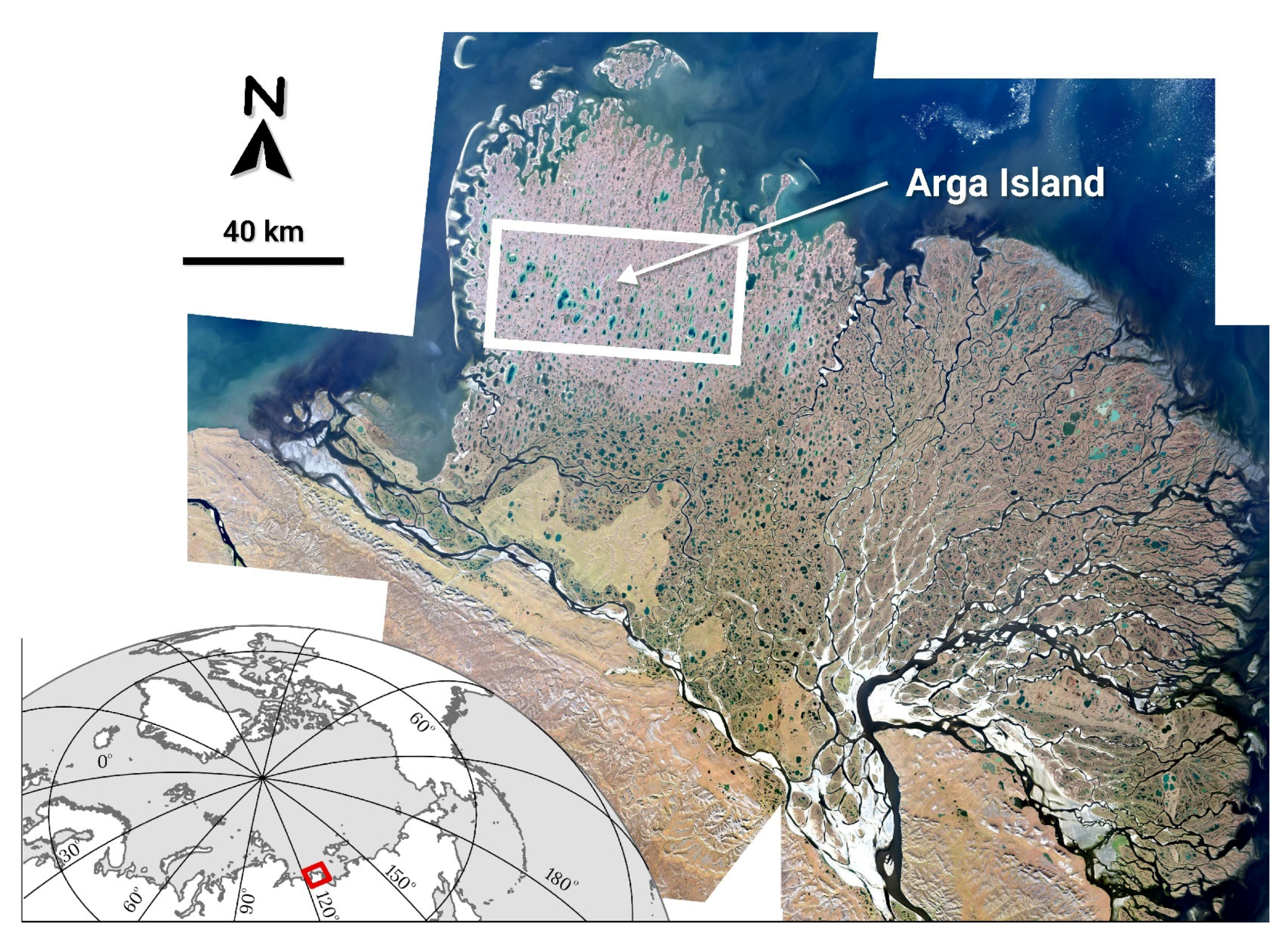
2.1. Study Area
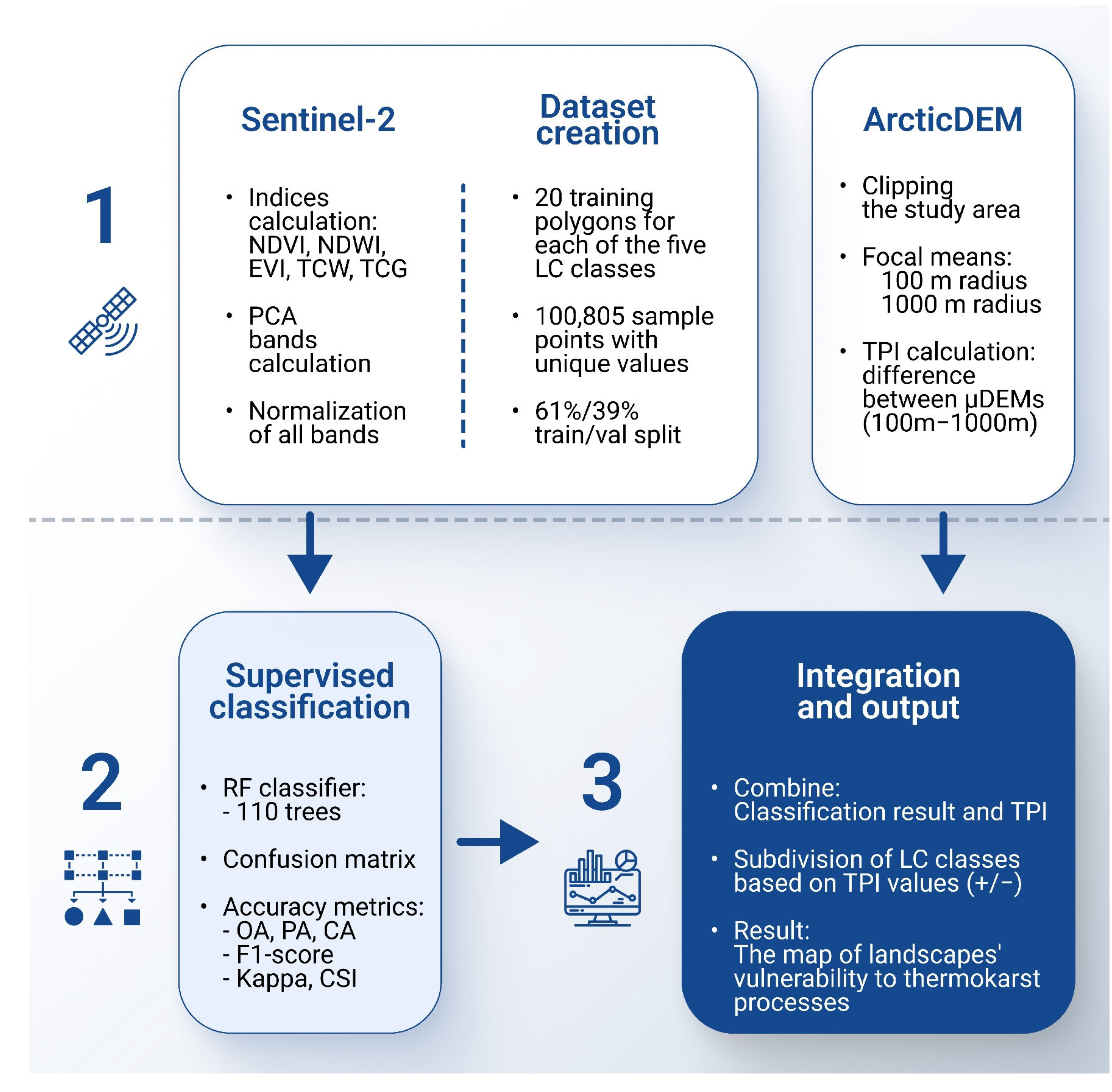
2.2. Data Processing
2.3. Supervised Classification and Its Accuracy Estimation
2.4. Morphometric Analysis
3. Results and Discussion
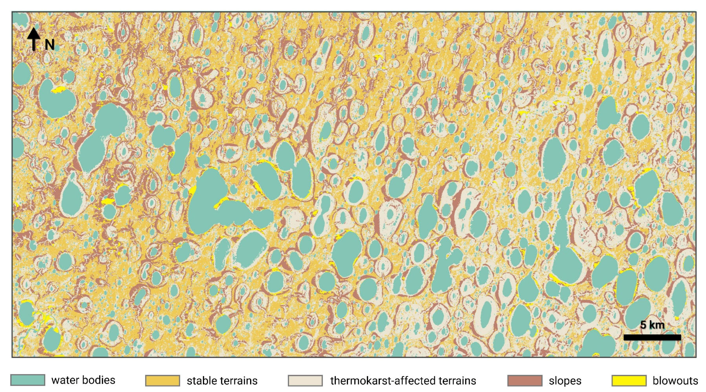
3.1. Classification Result and Accuracy Assessment
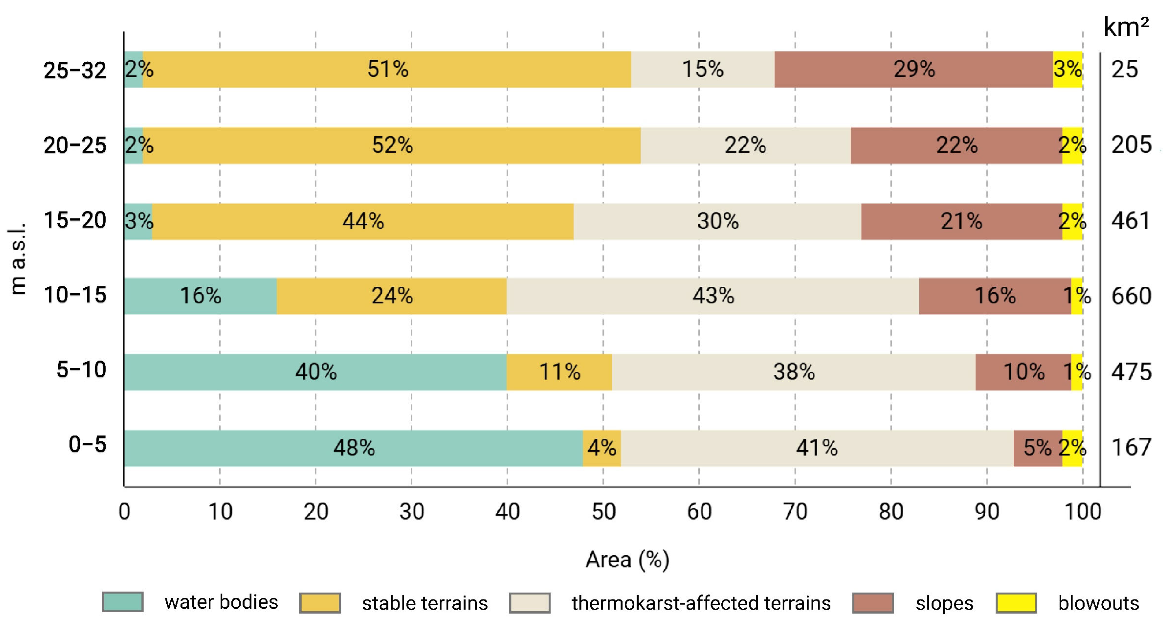
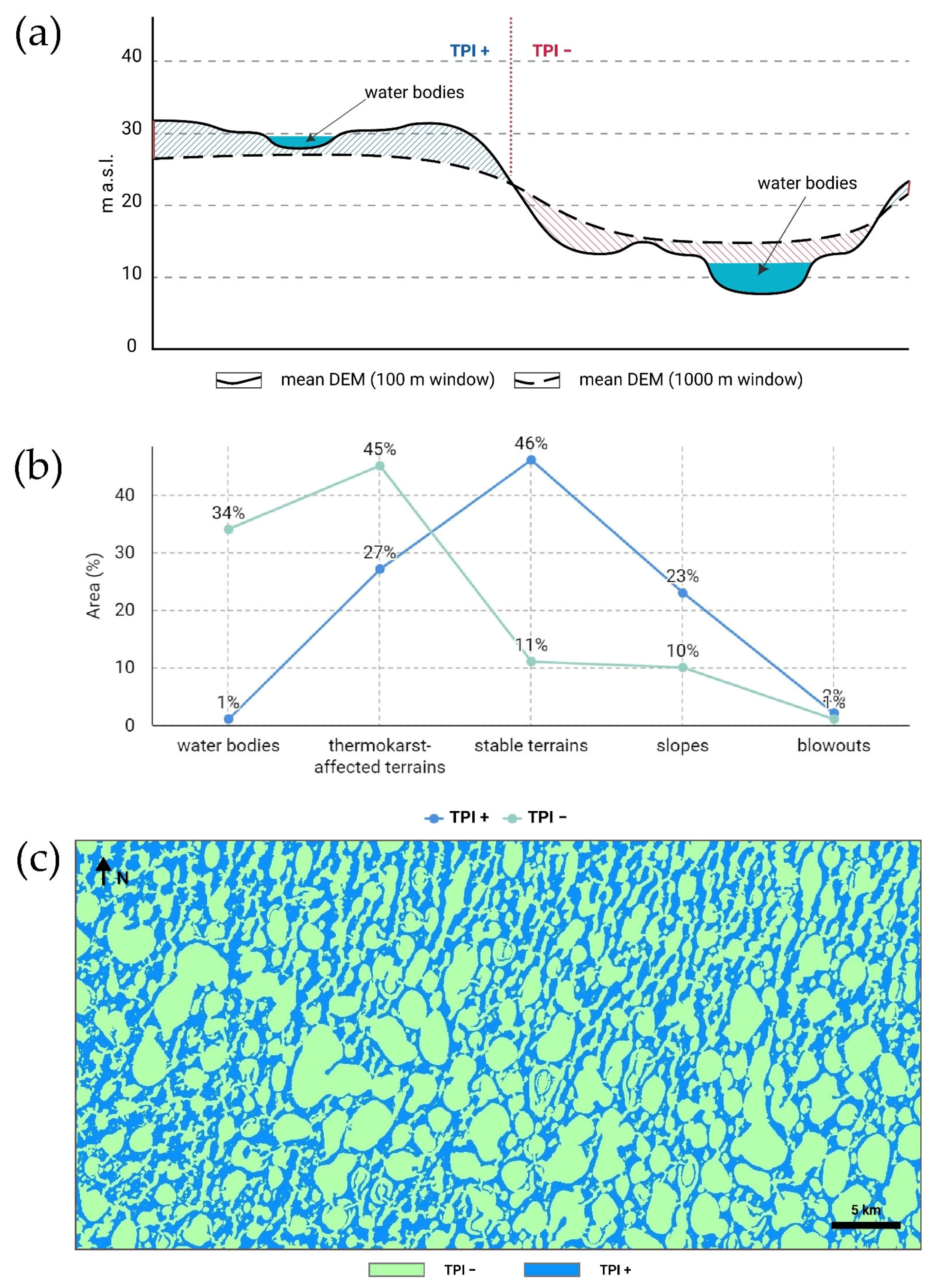
3.2. TPI
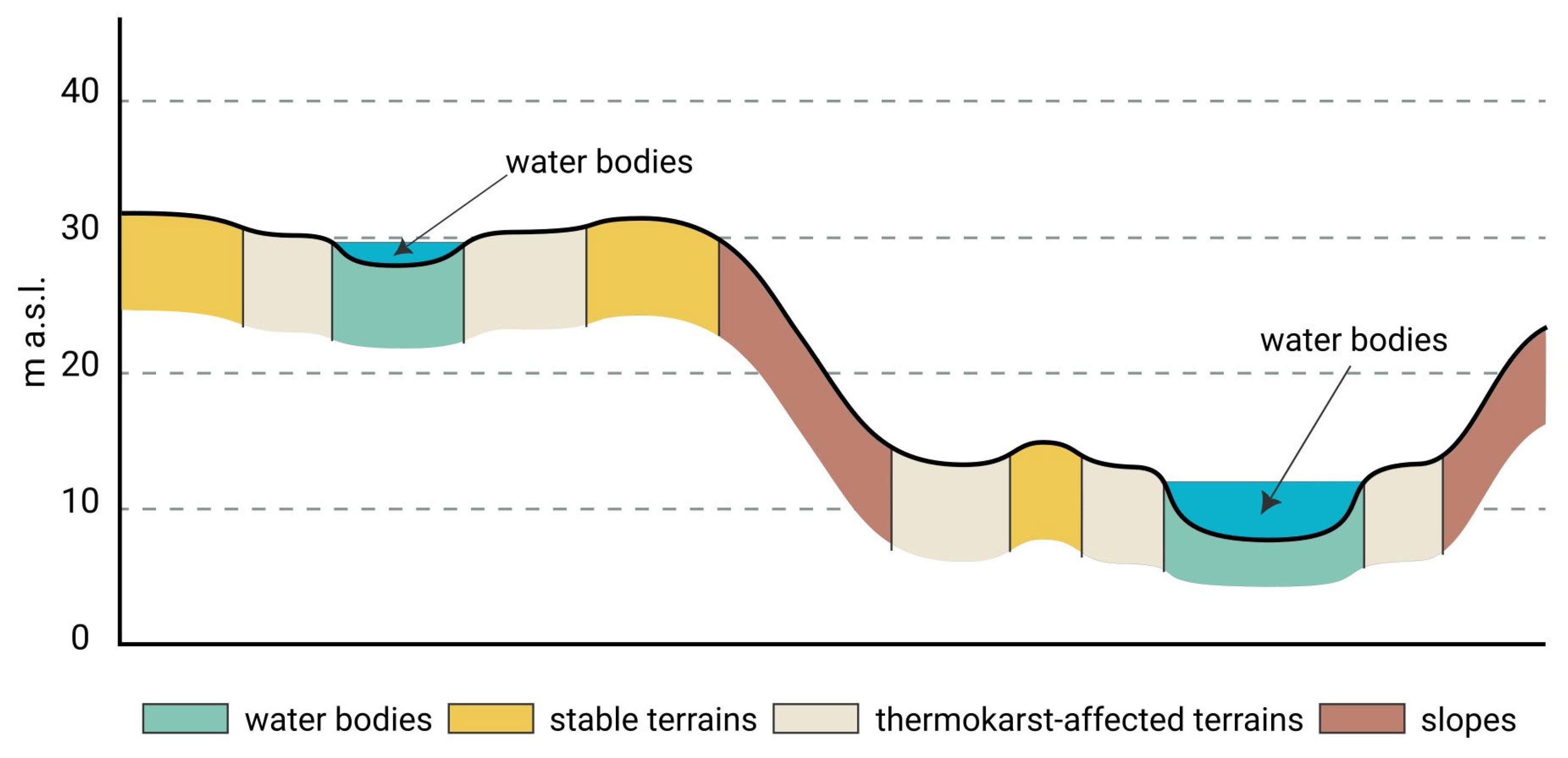
3.3. The Mapping of Areas Based on Their Vulnerability to Thermokarst Processes
- 1.
- The areas of stable terrains in the undegraded uplands (with positive TPI values) are relevant to the first stage of landscape evolution. The thermokarst processes in this area are not currently active. However, these areas have the highest potential for future permafrost degradation and associated landscape changes. Our estimation indicates that around one fifth of the analyzed area is relevant to this first stage of landscape evolution.
- 2.
- The thermokarst-affected terrains and water bodies in the undegraded uplands (with positive TPI values) concern the second stage. These areas have already begun to experience the effects of thermokarst activity, although the considerable degradation of permafrost has not yet occurred. Based on the area estimation, approximately 13% of the study area is covered by these terrains. We can reasonably expect that these areas will undergo significant changes in the near future, and they are hotspots of permafrost degradation.
- 3.
- The thermokarst-affected terrains and water bodies in the depressions and valleys (negative TPI values) refer to the third stage. They occupy a substantial amount of the study area (44%). A significant portion of the permafrost deposits have already been degraded in these areas. Nonetheless, thermokarst processes continue to occur within these territories, and the landscape has not yet reached a finished condition.
- 4.
- The stable terrains within the depressions and valleys (negative TPI values) are indicative of the final stage in the thermokarst landscape evolution. A minor part of the analyzed area comprises these stable surfaces, accounting for only 6%. The sandy permafrost deposits in this area have been completely degraded, and the elevation of the land surface is close to sea level. However, these areas have been stable for a sufficiently long period of time. They have become drier, and a later botanical succession is typical of them. We can assume that these areas have already undergone significant topographic changes and will remain stable in the future.
4. Conclusions
Funding
Data Availability Statement
Acknowledgments
Conflicts of Interest
Abbreviations
| CA | Consumer’s accuracy |
| CM | Confusion matrix |
| CSI | Classification success index |
| DEM | Digital elevation model |
| EVI | Enhanced vegetation index |
| GEE | Google Earth Engine |
| GIS | Geographic information system |
| LC | Land cover |
| ML | Machine learning |
| NDVI | Normalized difference vegetation index |
| NDWI | Normalized difference water index |
| OA | Overall accuracy |
| PA | Producer’s accuracy |
| PCA | Principal component analysis |
| RF | Random forest |
| RS | Remote sensing |
| TCG | Tasseled cap transformation for greenness |
| TCW | Tasseled cap transformation for wetness |
| TPI | Topographic position index |
References
- Lee, H.; Calvin, K.; Dasgupta, D.; Krinner, G.; Mukherji, A.; Thorne, P.; Trisos, C.; Romero, J.; Aldunce, P.; Barrett, K.; et al. Climate Change 2023: Synthesis Report. Contribution of Working Groups I, II and III to the Sixth Assessment Report of the Intergovernmental Panel on Climate Change; IPCC: Geneva, Switzerland, 2023. [Google Scholar]
- Cohen, J.; Screen, J.A.; Furtado, J.C.; Barlow, M.; Whittleston, D.; Coumou, D.; Francis, J.; Dethloff, K.; Entekhabi, D.; Overland, J.; et al. Recent Arctic Amplification and Extreme Mid-Latitude Weather. Nat. Geosci. 2014, 7, 627–637. [Google Scholar] [CrossRef]
- Serreze, M.C.; Barrett, A.P.; Stroeve, J.C.; Kindig, D.N.; Holland, M.M. The Emergence of Surface-Based Arctic Amplification. Cryosphere 2009, 3, 11–19. [Google Scholar] [CrossRef]
- Jansen, E.; Christensen, J.H.; Dokken, T.; Nisancioglu, K.H.; Vinther, B.M.; Capron, E.; Guo, C.; Jensen, M.F.; Langen, P.L.; Pedersen, R.A.; et al. Past Perspectives on the Present Era of Abrupt Arctic Climate Change. Nat. Clim. Chang. 2020, 10, 714–721. [Google Scholar] [CrossRef]
- Ziaja, W.; Ostafin, K. Origin and Location of New Arctic Islands and Straits due to Glacial Recession. Ambio 2019, 48, 25–34. [Google Scholar] [CrossRef]
- Obu, J.; Westermann, S.; Bartsch, A.; Berdnikov, N.; Christiansen, H.H.; Dashtseren, A.; Delaloye, R.; Elberling, B.; Etzelmüller, B.; Kholodov, A.; et al. Northern Hemisphere Permafrost Map Based on TTOP Modelling for 2000–2016 at 1 km2 Scale. Earth-Sci. Rev. 2019, 193, 299–316. [Google Scholar] [CrossRef]
- Streletskiy, D.; Anisimov, O.; Vasiliev, A. Chapter 10—Permafrost Degradation. In Snow and Ice-Related Hazards, Risks, and Disasters; Shroder, J.F., Haeberli, W., Whiteman, C., Eds.; Academic Press: Boston, MA, USA, 2015; pp. 303–344. ISBN 978-0-12-394849-6. [Google Scholar]
- Jorgenson, M.T. 8.20 Thermokarst Terrains. In Treatise on Geomorphology; Shroder, J.F., Ed.; Academic Press: San Diego, CA, USA, 2013; pp. 313–324. ISBN 978-0-08-088522-3. [Google Scholar]
- French, H.M. The Periglacial Environment, 4th ed.; Wiley, Blackwell: Hoboken, NJ, USA, 2017; ISBN 978-1-119-13281-3. [Google Scholar]
- Jorgenson, M.T.; Grosse, G. Remote Sensing of Landscape Change in Permafrost Regions. Permafr. Periglac. Process. 2016, 27, 324–338. [Google Scholar] [CrossRef]
- Duncan, B.N.; Ott, L.E.; Abshire, J.B.; Brucker, L.; Carroll, M.L.; Carton, J.; Comiso, J.C.; Dinnat, E.P.; Forbes, B.C.; Gonsamo, A.; et al. Space-Based Observations for Understanding Changes in the Arctic-Boreal Zone. Rev. Geophys. 2020, 58, e2019RG000652. [Google Scholar] [CrossRef]
- Chen, Y.; Liu, A.; Cheng, X. Landsat-Based Monitoring of Landscape Dynamics in Arctic Permafrost Region. J. Remote Sens. 2022, 2022, 9765087. [Google Scholar] [CrossRef]
- Philipp, M.; Dietz, A.; Buchelt, S.; Kuenzer, C. Trends in Satellite Earth Observation for Permafrost Related Analyses—A Review. Remote Sens. 2021, 13, 1217. [Google Scholar] [CrossRef]
- Westermann, S.; Duguay, C.R.; Grosse, G.; Kääb, A. Remote Sensing of Permafrost and Frozen Ground. In Remote Sensing of the Cryosphere; John Wiley & Sons, Ltd.: Hoboken, NJ, USA, 2015; pp. 307–344. ISBN 978-1-118-36890-9. [Google Scholar]
- Grosse, G.; Harden, J.; Turetsky, M.; McGuire, A.D.; Camill, P.; Tarnocai, C.; Frolking, S.; Schuur, E.A.G.; Jorgenson, T.; Marchenko, S.; et al. Vulnerability of High-Latitude Soil Organic Carbon in North America to Disturbance. J. Geophys. Res. Biogeosci. 2011, 116, 1–23. [Google Scholar] [CrossRef]
- Kokelj, S.V.; Jorgenson, M.T. Advances in Thermokarst Research. Permafr. Periglac. Process. 2013, 24, 108–119. [Google Scholar] [CrossRef]
- Schuur, E.A.G.; Mack, M.C. Ecological Response to Permafrost Thaw and Consequences for Local and Global Ecosystem Services. Annu. Rev. Ecol. Evol. Syst. 2018, 49, 279–301. [Google Scholar] [CrossRef]
- Beamish, A.; Raynolds, M.K.; Epstein, H.; Frost, G.V.; Macander, M.J.; Bergstedt, H.; Bartsch, A.; Kruse, S.; Miles, V.; Tanis, C.M.; et al. Recent Trends and Remaining Challenges for Optical Remote Sensing of Arctic Tundra Vegetation: A Review and Outlook. Remote Sens. Environ. 2020, 246, 111872. [Google Scholar] [CrossRef]
- Dubovik, O.; Schuster, G.L.; Xu, F.; Hu, Y.; Bösch, H.; Landgraf, J.; Li, Z. Grand Challenges in Satellite Remote Sensing. Front. Remote Sens. 2021, 2, 619818. [Google Scholar] [CrossRef]
- Phiri, D.; Simwanda, M.; Salekin, S.; Nyirenda, V.R.; Murayama, Y.; Ranagalage, M. Sentinel-2 Data for Land Cover/Use Mapping: A Review. Remote Sens. 2020, 12, 2291. [Google Scholar] [CrossRef]
- Gorelick, N.; Hancher, M.; Dixon, M.; Ilyushchenko, S.; Thau, D.; Moore, R. Google Earth Engine: Planetary-Scale Geospatial Analysis for Everyone. Remote Sens. Environ. 2017, 202, 18–27. [Google Scholar] [CrossRef]
- Zhao, Q.; Yu, L.; Li, X.; Peng, D.; Zhang, Y.; Gong, P. Progress and Trends in the Application of Google Earth and Google Earth Engine. Remote Sens. 2021, 13, 3778. [Google Scholar] [CrossRef]
- Yang, L.; Driscol, J.; Sarigai, S.; Wu, Q.; Chen, H.; Lippitt, C.D. Google Earth Engine and Artificial Intelligence (AI): A Comprehensive Review. Remote Sens. 2022, 14, 3253. [Google Scholar] [CrossRef]
- Hong, G.; Zhang, Y. Mapping Land Cover in the Low Arctic Using Multiple Sources of Earth Observation Data. Can. J. Remote Sens. 2024, 50, 2430496. [Google Scholar] [CrossRef]
- Merchant, M.; Brisco, B.; Mahdianpari, M.; Bourgeau-Chavez, L.; Murnaghan, K.; DeVries, B.; Berg, A. Leveraging Google Earth Engine Cloud Computing for Large-Scale Arctic Wetland Mapping. Int. J. Appl. Earth Obs. Geoinf. 2023, 125, 103589. [Google Scholar] [CrossRef]
- Kokelj, S.V.; Gingras-Hill, T.; Daly, S.V.; Morse, P.D.; Wolfe, S.A.; Rudy, A.C.A.; van der Sluijs, J.; Weiss, N.; Brendan O’Neill, H.; Baltzer, J.L.; et al. The Northwest Territories Thermokarst Mapping Collective: A Northern-Driven Mapping Collaborative toward Understanding the Effects of Permafrost Thaw. Arct. Sci. 2023, 9, 886–918. [Google Scholar] [CrossRef]
- Liu, C.; Xu, X.; Feng, X.; Cheng, X.; Liu, C.; Huang, H. CALC-2020: A New Baseline Land Cover Map at 10 m Resolution for the Circumpolar Arctic. Earth Syst. Sci. Data 2023, 15, 133–153. [Google Scholar] [CrossRef]
- Grigoriev, M.N. Criomorphogenesis in the Lena Delta; Permafrost Institute Press: Yakutsk, Russia, 1993; p. 176. [Google Scholar]
- Feliks Are; Reimnitz, E. An Overview of the Lena River Delta Setting: Geology, Tectonics, Geomorphology, and Hydrology. J. Coast. Res. 2000, 16, 1083–1093. [Google Scholar]
- Schwamborn, G.; Rachold, V.; Grigoriev, M.N. Late Quaternary Sedimentation History of the Lena Delta. Quat. Int. 2002, 89, 119–134. [Google Scholar] [CrossRef]
- Schwamborn, G.; Schirrmeister, L.; Mohammadi, A.; Meyer, H.; Kartoziia, A.; Maggioni, F.; Strauss, J. Fluvial and Permafrost History of the Lower Lena River, North-Eastern Siberia, over Late Quaternary Time. Sedimentology 2023, 70, 235–258. [Google Scholar] [CrossRef]
- Zolnikov, I.D.; Glushkova, N.V.; Kartoziya, A.A.; Chupina, D.A. The Geomorphological Zonation of the Lena River Delta East Part by Using GIS-Analysis. Geol. Miner. Resour. Sib. 2023, 1, 3–11. [Google Scholar] [CrossRef]
- Imaeva, L.P.; Gusev, G.S.; Imaev, V.S. Dynamics of the Relief and Sesmotectonic Activity of the Modern Structures in the Delta of the River Lena. Geotectonics 2019, 62–77. [Google Scholar] [CrossRef]
- Dergach, P.A.; Eponeshnikova, L.Y.; Ponasenko, S.N.; Kartoziia, A.A.; Geissler, W.H.; Duchkov, A.A.; Shibaev, S.V.; Zobnin, G.Y. Building a tomographic velocity model for Samoylov Island area (Lena Delta) from local seismological data for the period of 2019–2021. Geodin. Tektonofiz. 2022, 13, 627. [Google Scholar] [CrossRef]
- Zaplavnova, A.A.; Deev, E.V.; Potapov, V.V. Structure of the Upper Part of the Earth’s Crust in the Area of the Lena River Delta: The First Magnetotelluric Data. Dokl. Earth Sci. 2024, 514, 249–254. [Google Scholar] [CrossRef]
- Schwamborn, G.; Andreev, A.A.; Rachold, V.; Hubberten, H.-W.; Grigoriev, M.N.; Tumskoy, V.E.; Pavlova, E.Y.; Dorozhkina, M. Evolution of Lake Nikolay, Arga Island, Western Lena River Delta, during Late Pleistocene and Holocene Time. Polarforschung 2002, 70, 69–82. [Google Scholar]
- Andreev, A.; Tarasov, P.; Schwamborn, G.; Ilyashuk, B.; Ilyashuk, E.; Bobrov, A.; Klimanov, V.; Rachold, V.; Hubberten, H.-W. Holocene Paleoenvironmental Records from Nikolay Lake, Lena River Delta, Arctic Russia. Palaeogeogr. Palaeoclimatol. Palaeoecol. 2004, 209, 197–217. [Google Scholar] [CrossRef]
- Schneider, J.; Grosse, G.; Wagner, D. Land Cover Classification of Tundra Environments in the Arctic Lena Delta Based on Landsat 7 ETM+ Data and Its Application for Upscaling of Methane Emissions. Remote Sens. Environ. 2009, 113, 380–391. [Google Scholar] [CrossRef]
- Lisovski, S.; Runge, A.; Shevtsova, I.; Landgraf, N.; Morgenstern, A.; Okoth, R.R.; Fuchs, M.; Lashchinskiy, N.; Stadie, C.; Beamish, A.; et al. A New Habitat Map of the Lena Delta in Arctic Siberia Based on Field and Remote Sensing Datasets. Earth Syst. Sci. Data Discuss. 2023, 2023, 1707–1730. [Google Scholar] [CrossRef]
- Boike, J.; Nitzbon, J.; Anders, K.; Grigoriev, M.; Bolshiyanov, D.; Langer, M.; Lange, S.; Bornemann, N.; Morgenstern, A.; Schreiber, P.; et al. A 16-Year Record (2002–2017) of Permafrost, Active-Layer, and Meteorological Conditions at the Samoylov Island Arctic Permafrost Research Site, Lena River Delta, Northern Siberia: An Opportunity to Validate Remote-Sensing Data and Land Surface, Snow, and Permafrost Models. Earth Syst. Sci. Data 2019, 11, 261–299. [Google Scholar] [CrossRef]
- Chalov, S.; Prokopeva, K.; Magritsky, D.; Grigoriev, V.; Fingert, E.; Habel, M.; Juhls, B.; Morgenstern, A.; Overduin, P.P.; Kasimov, N. Climate Change Impacts on Streamflow, Sediment Load and Carbon Fluxes in the Lena River Delta. Ecol. Indic. 2023, 157, 111252. [Google Scholar] [CrossRef]
- Harmonized Sentinel-2 MSI: MultiSpectral Instrument, Level-2A. Available online: https://developers.google.com/earth-engine/datasets/catalog/COPERNICUS_S2_SR_HARMONIZED (accessed on 20 January 2025).
- Rouse, J.W.; Haas, R.H.; Deering, D.W.; Schell, J.A.; Harlan, J.C. Monitoring the Vernal Advancement and Retrogradation (Green Wave Effect) of Natural Vegetation; Great Plains Corridor; NASA: Washington, DC, USA, 1973. [Google Scholar]
- Gao, B. NDWI—A Normalized Difference Water Index for Remote Sensing of Vegetation Liquid Water from Space. Remote Sens. Environ. 1996, 58, 257–266. [Google Scholar] [CrossRef]
- Huete, A.; Didan, K.; Miura, T.; Rodriguez, E.P.; Gao, X.; Ferreira, L.G. Overview of the Radiometric and Biophysical Performance of the MODIS Vegetation Indices. Remote Sens. Environ. 2002, 83, 195–213. [Google Scholar] [CrossRef]
- Kauth, R.J.; Thomas, G.S. The Tasseled Cap—A Graphic Description of the Spectral-Temporal Development of Agricultural Crops as Seen by Landsat. In Proceedings of the Symposium on Machine Processing of Remotely Sensed Data, West Lafayette, IN, USA, 29 June–1 July 1976; pp. 41–51. [Google Scholar]
- Shi, T.; Xu, H. Derivation of Tasseled Cap Transformation Coefficients for Sentinel-2 MSI At-Sensor Reflectance Data. IEEE J. Sel. Top. Appl. Earth Obs. Remote Sens. 2019, 12, 4038–4048. [Google Scholar] [CrossRef]
- Crist, E.P.; Cicone, R.C. Application of the Tasseled Cap Concept to Simulated Thematic Mapper Data. Photogramm. Eng. Remote Sens. 1984, 50, 343–352. [Google Scholar]
- IDB—Index DataBase. Available online: https://www.indexdatabase.de/ (accessed on 20 January 2025).
- Kartoziia, A. Using Google Earth Engine to Assess the Current State of Thermokarst Terrain on Arga Island (the Lena Delta). Earth 2024, 5, 228–243. [Google Scholar] [CrossRef]
- Zhou, L.; Luo, T.; Du, M.; Chen, Q.; Liu, Y.; Zhu, Y.; He, C.; Wang, S.; Yang, K. Machine Learning Comparison and Parameter Setting Methods for the Detection of Dump Sites for Construction and Demolition Waste Using the Google Earth Engine. Remote Sens. 2021, 13, 787. [Google Scholar] [CrossRef]
- Belgiu, M.; Drăguţ, L. Random Forest in Remote Sensing: A Review of Applications and Future Directions. ISPRS J. Photogramm. Remote Sens. 2016, 114, 24–31. [Google Scholar] [CrossRef]
- Breiman, L. Random Forests. Mach. Learn. 2001, 45, 5–32. [Google Scholar] [CrossRef]
- Stehman, S.V. Selecting and Interpreting Measures of Thematic Classification Accuracy. Remote Sens. Environ. 1997, 62, 77–89. [Google Scholar] [CrossRef]
- Congalton, R.G.; Green, K. Assessing the Accuracy of Remotely Sensed Data: Principles and Practices, 2nd ed.; CRC Press: Boca Raton, FL, USA, 2008; ISBN 978-0-429-14397-7. [Google Scholar]
- Sasaki, Y.; The Truth of the F-Measure. University of Manchester, Technical Report, Version. Available online: https://people.cs.pitt.edu/~litman/courses/cs1671s20/F-measure-YS-26Oct07.pdf (accessed on 8 June 2025).
- Cohen, J. A Coefficient of Agreement for Nominal Scales. Educ. Psychol. Meas. 1960, 20, 37–46. [Google Scholar] [CrossRef]
- Koukoulas, S.; Blackburn, G.A. Introducing New Indices for Accuracy Evaluation of Classified Images Representing Semi-Natural Woodland Environments. Photogramm. Eng. Remote Sens. 2001, 67, 499–510. [Google Scholar]
- Labatut, V.; Cherifi, H. Evaluation of Performance Measures for Classifiers Comparison. arXiv 2011, arXiv:1112.4133. [Google Scholar]
- Weiss, A. Topographic Position and Landforms Analysis. In Proceedings of the Poster Presentation, ESRI User Conference, San Diego, CA, USA, 9–13 July 2001; Volume 200. [Google Scholar]
- De Reu, J.; Bourgeois, J.; Bats, M.; Zwertvaegher, A.; Gelorini, V.; De Smedt, P.; Chu, W.; Antrop, M.; De Maeyer, P.; Finke, P.; et al. Application of the Topographic Position Index to Heterogeneous Landscapes. Geomorphology 2013, 186, 39–49. [Google Scholar] [CrossRef]
- Porter, C.; Howat, I.; Noh, M.-J.; Husby, E.; Khuvis, S.; Danish, E.; Tomko, K.; Gardiner, J.; Negrete, A.; Yadav, B.; et al. ArcticDEM-Mosaics, Version 4.1. [Dataset]. Harv. Dataverse. 2023. Available online: https://dataverse.harvard.edu/dataset.xhtml?persistentId=doi:10.7910/DVN/3VDC4W (accessed on 8 June 2025).
- McRoberts, E.C.; Morgenstern, N.R. The Stability of Thawing Slopes. Can. Geotech. J. 1974, 11, 447–469. [Google Scholar] [CrossRef]
- Rowland, J.C.; Jones, C.E.; Altmann, G.; Bryan, R.; Crosby, B.T.; Hinzman, L.D.; Kane, D.L.; Lawrence, D.M.; Mancino, A.; Marsh, P.; et al. Arctic Landscapes in Transition: Responses to Thawing Permafrost. Eos Trans. Am. Geophys. Union 2010, 91, 229–230. [Google Scholar] [CrossRef]
- Rowley, T.; Giardino, J.R.; Granados-Aguilar, R.; Vitek, J.D. Chapter 13—Periglacial Processes and Landforms in the Critical Zone. In Developments in Earth Surface Processes; Giardino, J.R., Houser, C., Eds.; Elsevier: Amsterdam, The Netherlands, 2015; Volume 19, pp. 397–447. [Google Scholar]
- Walker, D.A.; Raynolds, M.K.; Daniëls, F.J.A.; Einarsson, E.; Elvebakk, A.; Gould, W.A.; Katenin, A.E.; Kholod, S.S.; Markon, C.J.; Melnikov, E.S.; et al. The Circumpolar Arctic Vegetation Map. J. Veg. Sci. 2005, 16, 267–282. [Google Scholar] [CrossRef]
- Liu, C.; Huang, H.; Sun, F. A Pixel-Based Vegetation Greenness Trend Analysis over the Russian Tundra with All Available Landsat Data from 1984 to 2018. Remote Sens. 2021, 13, 4933. [Google Scholar] [CrossRef]
- Chen, Z.; Pasher, J.; Duffe, J.; Behnamian, A. Mapping Arctic Coastal Ecosystems with High Resolution Optical Satellite Imagery Using a Hybrid Classification Approach. Can. J. Remote Sens. 2017, 43, 513–527. [Google Scholar] [CrossRef]
- Grosse, G.; Schirrmeister, L.; Malthus, T.J. Application of Landsat-7 Satellite Data and a DEM for the Quantification of Thermokarst-Affected Terrain Types in the Periglacial Lena–Anabar Coastal Lowland. Polar Res. 2006, 25, 51–67. [Google Scholar] [CrossRef]
- Bergstedt, H.; Jones, B.M.; Hinkel, K.; Farquharson, L.; Gaglioti, B.V.; Parsekian, A.D.; Kanevskiy, M.; Ohara, N.; Breen, A.L.; Rangel, R.C.; et al. Remote Sensing-Based Statistical Approach for Defining Drained Lake Basins in a Continuous Permafrost Region, North Slope of Alaska. Remote Sens. 2021, 13, 2539. [Google Scholar] [CrossRef]


| Band | Pixel Size (m) | Central Wavelength (nm) | Description |
|---|---|---|---|
| B1 | 60 | 442.3 | Aerosols |
| B2 | 10 | 492.1 | Blue |
| B3 | 10 | 559 | Green |
| B4 | 10 | 665 | Red |
| B5 | 20 | 703.8 | Red Edge 1 |
| B6 | 20 | 739.1 | Red Edge 2 |
| B7 | 20 | 779.7 | Red Edge 3 |
| B8 | 10 | 833 | NIR |
| B8A | 20 | 864 | Red Edge 4 |
| B9 | 60 | 943.2 | Water vapor |
| B11 | 20 | 1610.4 | SWIR 1 |
| B12 | 20 | 2185.7 | SWIR 2 |
| Index | Formula |
|---|---|
| Normalized Difference Vegetation Index (NDVI) | (B8 − B4)/(B8 + B4) |
| Normalized Difference Water Index (NDWI) | (B3 − B8)/(B3 + B8) |
| Enhanced Vegetation Index (EVI) | 2.5 × (B8 − B4)/((B8 + 6.0 × B4 − 7.5 × B2) + 1.0) |
| Tasseled Cap transformation—wetness (TCW) | 0.1509 × B2 + 0.1973 × B3 + 0.3279 × B4 + 0.3406 × B8 + 0.7112 × B11 + 0.4572 × B12 |
| Tasseled Cap transformation—greenness (TCG) | −0.2848 × B2 − 0.2435 × B3 − 0.5436 × B4 + 0.7243 × B8 + 0.0840 × B11 − 0.1800 × B12 |
Disclaimer/Publisher’s Note: The statements, opinions and data contained in all publications are solely those of the individual author(s) and contributor(s) and not of MDPI and/or the editor(s). MDPI and/or the editor(s) disclaim responsibility for any injury to people or property resulting from any ideas, methods, instructions or products referred to in the content. |
© 2025 by the author. Licensee MDPI, Basel, Switzerland. This article is an open access article distributed under the terms and conditions of the Creative Commons Attribution (CC BY) license (https://creativecommons.org/licenses/by/4.0/).
Share and Cite
Kartoziia, A. Machine Learning and Morphometric Analysis for Evaluating the Vulnerability of Tundra Landscapes to Thermokarst Hazards in the Lena Delta: A Case Study of Arga Island. GeoHazards 2025, 6, 31. https://doi.org/10.3390/geohazards6020031
Kartoziia A. Machine Learning and Morphometric Analysis for Evaluating the Vulnerability of Tundra Landscapes to Thermokarst Hazards in the Lena Delta: A Case Study of Arga Island. GeoHazards. 2025; 6(2):31. https://doi.org/10.3390/geohazards6020031
Chicago/Turabian StyleKartoziia, Andrei. 2025. "Machine Learning and Morphometric Analysis for Evaluating the Vulnerability of Tundra Landscapes to Thermokarst Hazards in the Lena Delta: A Case Study of Arga Island" GeoHazards 6, no. 2: 31. https://doi.org/10.3390/geohazards6020031
APA StyleKartoziia, A. (2025). Machine Learning and Morphometric Analysis for Evaluating the Vulnerability of Tundra Landscapes to Thermokarst Hazards in the Lena Delta: A Case Study of Arga Island. GeoHazards, 6(2), 31. https://doi.org/10.3390/geohazards6020031