Abstract
In early 2025, the Santorini–Amorgos area (Aegean Volcanic Arc, Greece) experienced a seismic swarm, with dozens of M ≥ 4.0 earthquakes and a maximum magnitude of M = 5.2. Beyond its seismological interest, the sequence was notable for triggering rare increased preparedness actions by Greek Civil Protection operational structures in anticipation of an imminent destructive earthquake. These actions included (i) risk communication, (ii) the reinforcement of operational structures with additional personnel and equipment on the affected islands, (iii) updates to local emergency plans, (iv) the dissemination of self-protection guidance, (v) the activation of emergency alert systems, and (vi) volunteer mobilization, including first aid and mental health first aid courses. Although it was in line with contingency plans, public participation was limited. Volunteers helped bridge this gap, focusing on vulnerable groups. The implemented actions in Greece are also compared with increased preparedness during the 2024–2025 seismic swarms in Ethiopia, as well as preparedness before the highly anticipated major earthquake in Istanbul (Turkey). In Greece and Turkey, legal and technical frameworks enabled swift institutional responses. In contrast, Ethiopia highlighted the risks of limited preparedness and the need to embed disaster risk reduction in national development strategies. All cases affirm that preparedness, through infrastructure, planning, communication, and community engagement, is vital to reducing earthquake impacts.
1. Introduction
When an earthquake occurs, seismic waves propagate rapidly, and shaking is typically felt within seconds, impacting both the natural and built environments. This short timeframe is insufficient for authorities and operational structures of the Civil Protection to implement increased preparedness actions or mitigate risks effectively. However, earthquake early warning systems (EEWS) have been developed in some regions to detect initial seismic activity and provide real-time alerts. These systems enable individuals, communities, and governmental entities located far from the rupture initiation point to take precautionary actions before the arrival of damaging seismic waves, thereby potentially reducing casualties and structural damage [1].
EEWS primarily mitigate direct impacts on public health, such as injuries and fatalities, and help prevent disruptions to critical infrastructure, thereby reducing secondary losses [1]. Currently, EEWS are fully operational in nine countries and have been tested for implementation in thirteen others [1]. Countries with fully implemented EEWS include the United States [2,3], Japan [4,5], Mexico [6], Romania [7], Turkey [8], Taiwan [9,10], South Korea [11], China [12], and India [13,14].
However, due to the complex geodynamic and seismotectonic characteristics of many seismically active regions, the applicability and effectiveness of these methods are not universal. In such cases, risk mitigation and reduction rely on measures implemented during the normal preparedness phase of the disaster management cycle and, when an imminent threat is identified, through an accelerated phase of increased preparedness. However, for earthquakes, the lack of reliable short-term forecasting and effective early warning systems makes such an increased preparedness phase impractical. Consequently, earthquake preparedness transitions directly from the normal preparedness phase to the emergency response and intervention phase immediately after a destructive event occurs. In regions experiencing increased seismic activity, Civil Protection authorities enhance preparedness and seismic risk communication through a combination of proactive measures, infrastructure assessments, and community engagement. These efforts aim to disseminate information, raise awareness, influence risk perception and behavior, and strengthen preparedness [15]. The overarching goal is to reduce vulnerability, improve emergency response effectiveness, and facilitate a more rapid recovery following seismic events.
One such case is the seismic sequence that occurred between Santorini and Amorgos Islands, within the Cyclades island complex (southern Aegean, Greece), from late January to mid-February 2025. This sequence, unprecedented not only in Greece but also on a global scale, raised several critical questions and concerns. These are primarily related to its evolution, duration, termination, comparison with previous seismic sequences in the region, and potential correlation with magmatic and volcanic activity, as well as with the offshore active and seismic faults of the area. Additionally, the intensifying seismic activity had notable implications for the natural environment, particularly the steep slopes of the Santorini caldera, as well as for the built environment, affecting residences, businesses, public services, and critical infrastructure. The economic impact was also substantial, with a focus on disruptions to key service sectors in the affected islands, including tourism, communications, and transportation.
The significance and rarity of this seismic sequence stem not only from the aforementioned issues about its evolution and triggered secondary effects but also from the challenges in emergency response and management of its impact. The early 2025 Santorini–Amorgos seismic crisis management marks the first instance in Greece in which increased preparedness measures were implemented in anticipation of an imminent geophysical hazard. Due to the unprecedented characteristics of this seismic sequence, both in Greece and globally, this application of increased preparedness actions ahead of a potential earthquake can be considered one of the few that have occurred to date.
This paper aims to examine and systematically present the increased preparedness actions adopted and implemented by the authorities and the operational structures of the Civil Protection system of Greece in response to the evolving and intensifying early 2025 seismic sequence in Santorini–Amorgos area. This study focuses on documenting the range of the actions implemented to safeguard the residents and visitors amid an escalating seismic crisis, which, due to its duration and the magnitude of the generated phenomena, raised concerns regarding the potential occurrence of a large and destructive earthquake. Notably, it highlights the first-ever activation of increased preparedness protocols in Greece prior to the manifestation of a large seismic event. Emphasis is placed on inter-institutional coordination, public risk communication, structural safety assessments, and emergency planning. Furthermore, this study aims to derive critical insights and transferable lessons to inform future seismic risk management strategies, particularly in geodynamically active regions that are subject to both seismic and volcanic hazards. In this context, references are made to other recent, and to a certain extent similar, seismic crises worldwide to highlight the similarities, differences, and shared lessons that can inform increased preparedness measures in anticipation of imminent geophysical disasters. One such case is the recent seismic activity in central Ethiopia, which occurred nearly simultaneously with that in the southern Aegean Sea. Both events had a significant impact on the daily lives and activities of the affected populations. Another relevant case is the preparedness efforts in anticipation of the highly anticipated Istanbul (Turkey) earthquake, which poses a substantial risk of widespread structural damage and, consequently, severe human and economic losses. These cases offer valuable insights for comparative analysis within the scope of the present study.
2. Methodology
The methodology of this study is based on a multi-disciplinary, descriptive, and evaluative approach to disaster preparedness analysis. We utilize the official documentation, real-time governmental decisions, and operational protocols activated during the early 2025 Santorini–Amorgos seismic crisis to construct a comprehensive account of the increased preparedness actions adopted and implemented by the authorities and operational structures of the Civil Protection system in Greece. Specifically, this study is informed by data obtained from the Civil Protection framework of Greece, including the emergency response and disaster management general plans for earthquakes. These frameworks provided the structural foundation upon which the presented increased preparedness actions were organized, and their practical application during the seismic crisis served as a basis for methodological assessment. This study also integrates scientific assessments from the Permanent Scientific Committees of the Earthquake Planning and Protection Organization (EPPO), including risk evaluations and recommendations that shaped policy responses during the escalating seismic activity.
Furthermore, this study employs a qualitative analysis of institutional coordination, emergency communication, and public engagement activities carried out during the early 2025 seismic crisis. The methodology includes systematic documentation of operational decisions, such as the suspension of public services, deployment of specialized emergency response units, public advisories via the European Emergency Number, 112, and evacuation planning by local authorities. Additionally, we present awareness-raising efforts and psychological support programs implemented by volunteer organizations like the Hellenic Red Cross, highlighting their role in enhancing community-level resilience. Geospatial data on seismic activity and landslide distribution are integrated to contextualize risk-informed decision-making processes, while the evolution of the seismic swarm is tracked through earthquake catalogues compiled by university seismological laboratories. Collectively, the methodology synthesizes scientific data, Civil Protection protocols, and operational outcomes to critically examine the transition from normal to increased preparedness in anticipation of a large and potentially destructive earthquake.
In order to complement the methodological framework of this study, a comparative component was also integrated, incorporating the analysis of two additional contemporary cases of increased preparedness in anticipation of an imminent geophysical disaster: the 2024–2025 seismic swarms in central Ethiopia and the preparedness measures associated with the highly anticipated large earthquake in Istanbul. This addition was methodologically justified on the grounds that both cases, although contextually and geographically distinct, share critical thematic intersections with the early 2025 Santorini–Amorgos seismic crisis. These include the anticipation of a potentially destructive seismic event, the adoption and implementation of increased preparedness actions either prior to or in the early phases of hazard escalation, and the engagement of multiple institutional, technical, and community-level actors in the disaster risk reduction process.
The inclusion of these cases was carried out through secondary data analysis, drawing from situation reports, operational updates, academic literature, and official documentation published by international entities focused on crisis response, humanitarian aid, and development support, such as the United Nations Office for the Coordination of Humanitarian Affairs (UNOCHA), the European Civil Protection and Humanitarian Aid Operations (ECHO), and the World Bank Group (WBG), as well as national Civil Protection bodies. This comparative perspective allows for a broader and more critical evaluation of the preparedness measures implemented in the early 2025 Santorini–Amorgos seismic crisis by situating them within a wider spectrum of responses under similar seismic threat conditions. It offers the opportunity to assess the relative effectiveness, adaptability, and scalability of the Greek approach in contrast with the high-capacity, legally institutionalized system of Istanbul and the low-resource, humanitarian-coordinated response observed in Ethiopia. Methodologically, this comparison supports the extraction of shared lessons, contributes to the generalizability of the findings, and informs future risk management strategies through evidence-based, comparative learning.
While this study focuses on documenting increased preparedness actions in anticipation of an imminent disaster and drawing comparative insights and shared lessons for future cases and related studies, it does not apply a standardized set of outcome metrics due to the diversity of contexts and the emergent nature of several increased preparedness efforts. Future research should aim to incorporate quantitative indicators to assess the effectiveness and replicability of preparedness measures across different risk settings.
3. Institutional Framework for Disaster Prevention and Management in Greece
3.1. The Legal Framework of the Civil Protection in Greece
The legislative framework governing Civil Protection in Greece is primarily established by Law 4662/2020 [16], with subsequent amendments introduced by Law 5075/2023 [17], which enhanced the disaster management system and restructured Civil Protection operations. These laws delineate the organizational structure, responsibilities, and interagency coordination across all phases of the disaster management cycle: prevention, preparedness, response, and recovery. The key entities involved include the General Secretariat for Civil Protection (GSCP), the Fire Service, the Hellenic Police, the Hellenic Coast Guard, and the Armed Forces, among others. Under the jurisdiction of the Ministry for Climate Crisis and Civil Protection (MCCCP), the GSCP serves as the central coordinating body, ensuring an integrated and efficient response to crises and disasters arising from natural and technological hazards at national, regional, and local levels.
A fundamental component of Greece’s Civil Protection system is the General Civil Protection Plan, known as “Xenocrates” [18], which outlines the strategic framework for disaster prevention, preparedness, response, and recovery. This plan specifies the coordination mechanisms among agencies to safeguard human life, public health, private property, and the natural environment. Additionally, the European emergency service line, 112 [19], is activated to provide real-time alerts to citizens in the event of an imminent or ongoing disaster.
Given Greece’s complex geodynamic, seismotectonic, and geoenvironmental properties, seismic resilience and earthquake risk reduction are integral to national disaster risk reduction strategies, infrastructure management, and societal preparedness [20]. The national framework for earthquake emergency response is comprehensively detailed in the General Plan for Emergency Response and Earthquake Impact Management. This plan, named “Enceladus” after the leader of the Giants in Greek mythology, a descendant of Gaia (Earth) and Uranus (Sky) [21,22], was initially approved in 2019 [23] and was updated in 2022 [24]. It delineates a structured approach at the central, regional, and local levels across all disaster management phases, comprising pre-disaster mitigation, real-time response, and post-disaster recovery. The Enceladus plan encompasses measures ranging from seismic hazard assessments, seismic risk reduction, and area evacuations to damage assessment and restoration. In the event of a destructive earthquake, it facilitates the immediate emergency response and coordinated management of the earthquake’s impact on the population, infrastructure, and the natural environment.
The effectiveness of the earthquake preparedness plan has been evaluated not only through its application in operational exercises [25] but also in real conditions, during and after destructive earthquakes in Greece [26]. The most recent seismic events, for which the Enceladus plan was implemented, with emphasis on the immediate response and recovery phases, include the 30 October 2020, Mw = 7.0 earthquake in Samos Island (eastern Aegean Sea) [27], the 3 March 2021, Mw = 6.1 earthquake in Thessaly (Central Greece) [28], and the 27 September 2021, Mw = 5.9 earthquake in Arkalochori (Central Crete) [29]. Although these events resulted in relatively low casualties among the affected populations in Greece (two child fatalities in Samos due to the collapse of an abandoned masonry house, one elderly fatality in Thessaly after being trapped in rubble, and one fatality in Crete following the collapse of a small church), they caused significant damage to the natural environment, as well as to buildings and infrastructure.
Regarding the volcanic hazard and risk in Greece, the General Emergency Response Plan for Volcanic Activity [30] has been established for the volcanic complex of Santorini, named after the mythological Talos. He was a bronze giant created by Hephaestus and gifted to Minos, the King of Crete, and tasked with protecting Crete Island from invaders and pirates by hurling rocks at those who posed a threat. In this context, Talos is symbolically represented by the Santorini Island, which shielded Crete from northern threats. His unbreakable bronze body is likened to the caldera walls, while the rocks he threw correspond to the craters of the volcano. The demise of Talos, as described in myth, is attributed to the intervention of the Argonauts. This event is thought to symbolically reflect the cessation of the eruption of the Santorini volcano, which had already expelled vast quantities of volcanic material.
The following primary actions are being implemented under the updated “Talos” plan [30]: (i) measures to enhance preparedness against volcanic activity and (ii) actions for emergency response and the immediate/rapid management of the consequences of volcanic events. Volcanic activity encompasses a range of catastrophic phenomena, which are either directly linked to the release of volcanic materials from the volcanic system (e.g., ash suspension and fall, volcanic gas emissions, hydrothermal eruptions, hot water and steam jets, ejection of debris, lava flows, volcanic domes, and hydro-volcanic eruptions) or are secondary or induced phenomena (e.g., volcanic tremors, landslides triggered by volcanic seismicity, surface ruptures, and tsunamis generated by submarine volcanic eruptions or triggered landslides).
In the event that volcanic activity triggers earthquakes, the provisions of the “Enceladus 2” general plan [24] will be implemented to address emergency needs and ensure the immediate and rapid management of their effects. Similarly, in the case of a tsunami triggered by volcanic activity, the provisions of the “Dardanos 2” plan [31], which is activated during flooding events, will be applied to manage emergencies and facilitate the immediate and rapid response to its impacts.
3.2. Phases and Actions of the Civil Protection Mobilization System for Earthquakes in Greece
The phases of the Civil Protection mobilization system for earthquakes in Greece are as follows: (i) prevention measures under normal preparedness, (ii) increased preparedness actions in anticipation of an imminent earthquake, (iii) emergency response operations, including the immediate mobilization, intervention, and short-term management of earthquake impacts, and (iv) immediate relief efforts for affected populations alongside the short-term rehabilitation of disaster impact (Table 1) [20,24,26]. During the first phase, prevention measures and actions are being implemented by all stakeholders, which contribute to their preparation for dealing with emergencies and the immediate/rapid management of earthquake effects [24] (Table 1).

Table 1.
Four phases and related actions of the Civil Protection mobilization system in Greece according to the “Enceladus 2” plan for earthquakes [20,24,26,32].
Due to the inherent unpredictability of earthquakes and inefficiency in accurately forecasting earthquakes in the short term, early warning is not incorporated into earthquake risk management planning, and the second phase of the increased preparedness actions in response to an imminent earthquake in the “Enceladus” and “Enceladus 2” plans has never been implemented in Greece. The standard earthquake disaster management cycle in Greece typically begins with the first phase of the prevention actions under normal preparedness conditions (Table 1). Following an earthquake, the second phase of increased preparedness is omitted, giving way to the third phase of response (Table 1), whiche encompasses the immediate mobilization and on-site intervention of the authorities and operational structures of the Civil Protection system (security forces, health services, public utility services, the armed forces, and volunteer teams), and subsequently to the fourth phase, which focuses on post-earthquake relief, recovery, and rehabilitation (Table 1). The second phase, which is designed to increase preparedness in anticipation of an imminent earthquake (Table 1), is usually conceptualized as an extension of normal preparedness rather than an acceleration of existing measures or an intensification of preparedness actions. However, the GSCP may elevate the operational preparedness of Civil Protection staff and resources based on the assessments of the specialized seismic risk evaluation committees within the Permanent Special Scientific Committee for Seismic Hazard and Seismic Risk Reduction Division of the EPPO in Greece.
4. The Early 2025 Santorini–Amorgos Seismic Sequence and Its Secondary Environmental Effects
4.1. Geodynamic and Seismotectonic Setting of Santorini–Amorgos Area
The central Aegean region is predominantly characterized by the numerous islands of the Cyclades (Figure 1). Analysis of bathymetric and seismic reflection data indicates the presence of three NE-SW trending grabens, namely the Anydros, Santorini–Anafi, and Amorgos grabens, which exhibit a NW-ward tilt [33]. These grabens are part of the Santorini–Amorgos Tectonic Zone, an extensional structure approximately 60–70 km in length and 20–25 km in width, situated between the Cyclades Plateau to the north and the Anafi–Astypalaea Plateau to the south (Figure 1) [34]. The grabens are bounded by major fault systems with significant throws and are separated by intervening horsts (Figure 1). Specifically, the Santorini–Anafi graben, with a maximum depth of 726 m, is delimited from the Anydros graben (maximum depth of 511 m) and the Amorgos graben (maximum depth of 755 m) by the Anydros horst [33].
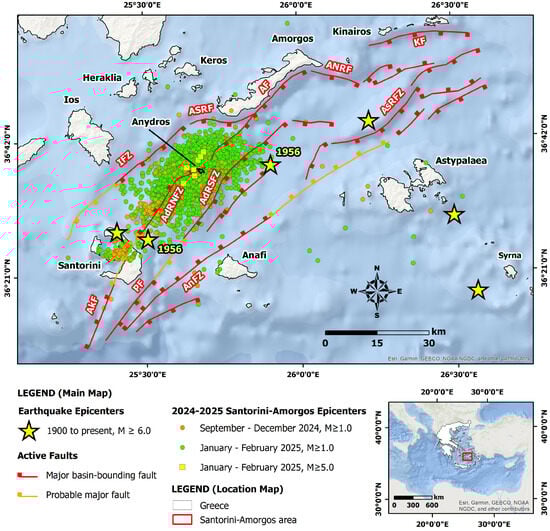
Figure 1.
Santorini–Amorgos area that was mainly affected by the early 2025 earthquake sequence, along with the major basin-bounding faults and the probable major faults (ticks on the hanging wall) based on the tectonic and kinematic map of the Santorini–Amorgos Shear Zone published by Tsampouraki-Kraounaki et al. [34]. The epicenters of the M ≥ 6.0 earthquakes since 1900 are from the earthquake catalogue of Makropoulos et al. [35], and the epicenters in the affected area from September 2024 to February 2025 were recorded at the Seismological Laboratory of the National and Kapodistrian University of Athens (SL-NKUA) [36]. AdRNFZ: Anydros Ridge North Fault Zone; AdRSFZ: Anydros Ridge South Fault Zone; AF: Amorgos Fault; AkF: Akrotiri Fault; AnFZ: Anafi Fault Zone; ANRF: Amorgos North Relay Fault; ASRF: Amorgos South Relay Fault; AsRFZ: Astypalaea Ridge Fault Zone; IFZ: los Fault Zone; KF: Kinairos Fault; PF: Perissa Fault. Sources of the basemap: Esri, Garmin, GEBCO, NOAA NGD, and other contributors.
This region has been impacted by multiple destructive earthquakes throughout both historical and recent times. Among these, the most significant event was the 9 July 1956, M = 7.8 Amorgos earthquake (Figure 1), which stands as the strongest earthquake to have occurred in Greece during the 20th century. Analysis of aftershock relocations by Okal et al. [37] suggests that the causative fault plane dips shallowly towards the southeast, a finding that is corroborated by bathymetric and seismic reflection data presented by Nomikou et al. [33]. The earthquake inflicted extensive damage across several islands, including Santorini, Amorgos, Anafi, Astypalaea, Ios, Paros, Naxos, Kalymnos, Leros, Patmos, and Lipsi [38]. In total, 529 houses were completely destroyed, while 1482 sustained severe damage and 1750 experienced minor structural effects, and the mainshock and the largest aftershock of M = 6.9, which occurred 13 min later, resulted in 53 fatalities and 100 injuries [38]. It also triggered the largest tsunami reported in the 20th century over the whole Mediterranean Basin with run-up values of up to 20 m on several islands in the southern Aegean Sea [37]. It was triggered either by offshore landslides [39,40] or a large seafloor rupture [41].
4.2. Evolution of the 2025 Seismic Crisis and Its Seismological Properties
In June 2024, microseismic activity was detected within the Santorini caldera, with a noticeable intensification beginning in mid-September [42] (Figure 1). This represents the first notable episode of microseismicity within the caldera since the 2011–2012 unrest period. Between June 2024 and 25 January 2025, over 1200 earthquakes were detected in the Santorini–Kolumbo area using modern machine learning-based seismic detection methods [42]. The largest event occurred on 25 January 2025 at 08:57:25 (local time), with M = 3.8, and was located off the northern coast of Thirassia Island.
On 26 January, a new cluster of earthquakes occurred east of the submarine volcano Kolumbo, with a strong increase in the following days [36] (Figure 1). From 26 January to 31 January, the number of recorded events gradually increased from 6 on 26 January to 31 on 31 January [36] (Figure 2). A sharp increase was noted in early February 2025.
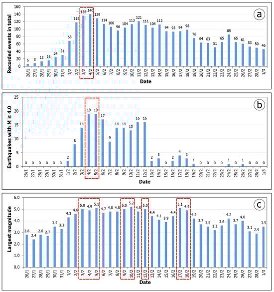
Figure 2.
Evolution of the seismic sequence of Santorini–Amorgos from 26 January to 1 March 2025 based on the data of the seismic catalogues compiled by the SL-NKUA [36]. The first graph (a) shows the total number of seismic events per day, reflecting the evolution of seismic activity. The second graph (b) shows the daily number of earthquakes with magnitudes of M ≥ 4.0, highlighting the days with the most intense earthquakes. The third diagram (c) records the maximum earthquake magnitude per day, allowing the strongest earthquakes of the period to be monitored. The red polygons highlight the most difficult days of the seismic crisis in terms of the number of generated seismic events and the recorded earthquake magnitude per day.
In particular, on 1 February, events soared to 68, while on 3 and 4 February, a peak was observed, with 136 and 140 events, respectively (Figure 2a). After 5 February (129 events), there was a gradual decrease, with small fluctuations, around 100–120 events per day until 14 February. From 15 February onward, events decreased gradually, with the exception of 18 and 24 February, when there was an increase to 98 and 85, respectively, while from 20 February onward, values dropped below 70 events per day [36] (Figure 2a). On 1 March, the number of recorded events was 46, marking a further decline [36].
For earthquakes with magnitudes of M ≥ 4.0, the main seismic activity occurred between 1 and 12 February, with a peak on 3 and 4 February (19 events) [36]. After 12 February, there was a significant decrease, with very few earthquakes after 18 February. From 27 February onwards, no earthquakes with magnitudes of M ≥ 4.0 occurred (Figure 2b). Regarding the largest recorded seismic magnitude, the first wave of intense seismic activity started on 1 February and peaked between 3 and 10 February, with magnitudes ranging from M = 5.0 to M = 5.2 [36]. After 10 February, there was a gradual decrease in the magnitude of the larger earthquakes, with the exception of 17 February, when an M = 5.1 earthquake is recorded, while from 20 February onward, seismic activity weakened significantly [36] (Figure 2c).
Based on the aforementioned findings, beginning on 1 February, there was a sharp increase in both the number of earthquakes and their magnitude. The days with the highest seismic activity were 3 and 4 February, with 136 and 140 seismic events recorded, respectively. Regarding earthquakes with M ≥ 4.0, the highest occurrence was observed on 4 and 5 February, with 19 earthquakes per day. Finally, the largest earthquake of the sequence occurred on 10 February, with M = 5.2.
Regarding the spatial distribution of the seismic sequence, the initial epicenters were located northeast of Santorini and east of the submarine volcano Kolumbo (Figure 1). The sequence later migrated northeastward, toward the islet of Anydros [32]. In the subsequent period, seismicity was recorded in the area surrounding Anydros, with most activity occurring southwest of the islet (Figure 1). On several days, earthquake epicenters were observed either migrating to the northeast or east of the islet or occurring simultaneously to the southwest and northeast of Anydros [36].
4.3. Secondary Earthquake Environmental Effects
A recent study by Mavroulis et al. [43] on earthquake-triggered landslides in Greece highlights the significant history of such events in Santorini. Landslides have been documented on the slopes of the caldera since ancient times, particularly from 1507 onward. These landslides are associated with both historical and recent seismic events, with the most notable occurrences in 1507, 1508, 1870, 1926, and 1956 [43]. It is important to note that these landslides were triggered not by earthquakes within the Santorini caldera itself but by seismic events with epicenters located outside the volcanic complex, such as those originating from the Crete and Rhodes islands located to the south and southeast of Santorini, respectively [43].
A similar phenomenon was observed during the early 2025 Santorini–Amorgos seismic sequence. The secondary effects include landslides not only on the slopes of the Santorini caldera, but also in areas outside of it [44] (Figure 3). Specifically, these areas include (i) the southern coastal part of Santorini, outside of the caldera; (ii) the central-eastern part of the steep slopes of the caldera; and (iii) the northern part of the island. The first area includes rockfalls triggered upslope of the Red Beach and slides upslope of Vlichada Beach. The second area is located upslope of the port of Athinios, at Alonaki Cape located at a distance of 1.5 km north of the port of Athinios, upslope of the old port of Fira, downslope of Imerovigli, and on the slope of the area of Skaros in Imerovigli. The third one is located along the Fira–Oia provincial road [44] (Figure 3 and Figure 4). The triggered effects were mapped and verified through field visits conducted by the authors on the island during the evolution of the early 2025 seismic sequence, as well as through testimonies from residents of Santorini, who witnessed these events.
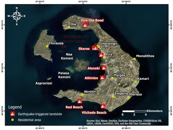
Figure 3.
Map showing the spatial distribution of the landslides in Santorini triggered by the early 2025 earthquake sequence. Sources of the basemap: Esri, Maxar, GeoEye, Earthstar Geographics, CNES/Airbus DS, USDA, USGS, AeroGRID, IGN, and the GIS User Community.
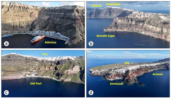
Figure 4.
Panoramic drone views of areas in Santorini Island, where rockfalls were triggered by the early 2025 Santorini–Amorgos earthquake swarm. (a) Athinios Bay and the steep slope south of the port, (b) the central part of the caldera, with Alonaki Cape and Skaros Rock located west of Imerovigli Village, (c) the old port of the island downslope of Fira Town, and (d) the northern part of Santorini, with Armeni and Ammoudi coastal settlements downslope of Oia Village.
Common to all sites is the presence of steep slopes, unstable volcanic materials, and scree from previous landslides. However, the impact of the recorded landslides was different from site to site [44]. At Red Beach, due to the fall of rock fragments, the volume of accumulated materials at the base of the slope has increased. It should be noted that the beach has been inaccessible for years due to previous rockfalls.
At Vlichada Beach, the impact is not localized but extends along a significant portion of the beach slopes. The mobilization of unstable deposits and their subsequent accumulation at the base of the nearly vertical slopes have substantially reduced the beach’s width. However, due to wave dynamics and the area’s lithological properties, the natural redistribution of geomaterials within the coastal zone is expected to facilitate the beach’s gradual restoration to its previous state over time.
Upslope of the Athinios port, earthquake-triggered landslides were of limited extent. The recorded rockfalls did not impact the port facilities, passenger waiting area, catering establishments, shops, or open-air parking, all of which are located within the coastal zone. North of the port, landslides occurred on a slope situated away from elements of the built environment, comprising residential buildings, utility networks, and other facilities. A portion of the unstable material accumulated in the sea.
Further north, in the Fira, Imerovigli, and Skaros areas, the recorded phenomena occurred downslope of the residential areas of Fira and Imerovigli, which are situated along the rim of the caldera. Similar to Athinios Bay, no impacts on the built environment were reported or recorded.
In the northern part of the island, along the road network leading from Oia to Fira, rockfalls led to hazardous conditions, requiring vehicles to pass through the area with increased caution.
5. Increased Preparedness Actions for an Imminent Earthquake
The management of the earthquake crisis in the Santorini–Amorgos area represents the first documented implementation of increased preparedness actions in anticipation of an imminent earthquake in Greece and among few recorded worldwide. This chapter presents the actions adopted and implemented by the authorities and the operational structures of the Civil Protection system to inform and raise awareness among the affected population, as well as to safeguard them from the ongoing and intensifying seismic sequence and its associated phenomena. The primary objective in all cases was to effectively mitigate the impact of a potential major earthquake and to reduce the risks associated with the related geohazards.
5.1. Risk Communication
5.1.1. Joint Meetings of Seismic and Volcanic Risk Assessment Committees and Dissemination of Related Information to the Population
Due to ongoing seismic activity, a series of joint meetings were convened by the Permanent Scientific Committee for Seismic Hazard Assessment and Seismic Risk Reduction, along with the Permanent Scientific Committee for the Monitoring of the Aegean Volcanic Arc under the EPPO. During these meetings, all newly acquired data related to the evolving seismic sequence were thoroughly analyzed. As part of this initiative, the MCCCP issued official announcements presenting key findings of the aforementioned committees on the seismic sequence, including its potential correlation with volcanic activity and active offshore faults in the Santorini–Anydros–Amorgos area. These announcements also outlined the increased preparedness measures proposed by the committees, primarily concerning the following points:
- Suspension of educational activities across all institutional levels (kindergartens, nurseries, primary and secondary schools);
- Avoidance of large gatherings in enclosed spaces;
- Avoidance of approaching old, abandoned, and unstable masonry buildings;
- Restriction of access to and presence in the ports of the Santorini Caldera without permission from the port authorities;
- Removal of hazardous non-structural elements from buildings, including residential buildings and tourist facilities;
- Guidelines for the selection of safe routes when traveling along roads through urban and rural areas, particularly in areas close to steep slopes characterized by high susceptibility to landslides;
- Guidelines for the immediate evacuation of coastal areas in the event of strong earthquakes.
The meetings were held on 19 January, as well as on 1, 2, 3, 8, 16, 22, and 27 February 2025, during the most difficult period of the seismic sequence in terms of numbers of generated seismic events with M ≥ 4.0 and the recorded magnitudes. On 5 February 2025, a meeting took place under the auspices of the Prime Minister of the Hellenic Republic and the MCCCP, followed by a public briefing. This briefing, which was broadcast on the TV and radio, featured three professors from the National and Kapodistrian University of Athens and the Aristotle University of Thessaloniki [45]. During this event, key aspects of the volcanic and seismotectonic environment of the Santorini–Amorgos area were presented, including the main characteristics of the evolving seismic sequence, the status of the volcanoes, and the associated geophysical hazards, such as earthquake-triggered landslides and tsunamis [45].
5.1.2. Awareness Raising and Education Actions
The EPPO is the designated authority responsible for the planning and effective implementation of Greece’s earthquake policy. In addition to its core responsibilities, the EPPO is actively involved in raising public awareness, as well as informing and educating the population on earthquake-related matters [46]. Aiming to mitigate the destructive effects of earthquakes, assess seismic hazard, and reduce seismic risk in Greece, the EPPO contributes significantly to the enhancement of earthquake awareness and risk reduction efforts. The organization’s scientific, technical, educational, and social initiatives target a wide range of groups, including geoscientists, engineers, educators, members of Civil Protection authorities, volunteers, public and private sector employees, the general public, tourism professionals, and vulnerable populations, such as individuals with disabilities [46].
In response to the early 2025 seismic sequence, the EPPO, alongside the joint meetings of the aforementioned permanent committees and the subsequent announcements regarding increased preparedness measures, also implemented actions to raise awareness of specific groups of the affected population. More specifically, the EPPO organized a webinar titled “Experiencing an Earthquake Period: Earthquake Protection of School Units” in collaboration with the Municipality of Thira [47]. The webinar was attended by school directors, heads of kindergartens, and nursery managers within the Municipality of Thira.
5.2. Strengthening the Operational Capabilities of Security Forces on the Affected Islands
5.2.1. Contribution of the Hellenic Fire Service
In response to the seismic activity on Santorini, the Hellenic Fire Service reinforced its presence with additional personnel, equipment, and vehicles (Figure 5a–c). From the onset of the intense seismic sequence, members of the First and the Eighth Special Disaster Management Units (SDMU; EMAK in Greek), equipped with rescue dogs, special rescue vehicles and specialized equipment, were deployed to Santorini and Amorgos Islands respectively (Figure 5c). Additionally, personnel from the First Special Forest Operations Unit, equipped with relevant resources, and the Unmanned Aircraft Systems (UAS) Team from the Attica Regional Fire Department, with two drones, were dispatched to Santorini. For enhanced coordination, the Mobile Operations Centre titled “Olympos” was also deployed to Santorini (Figure 5b). This center is equipped with advanced technology, including information and communication workstations, high-definition drones for real-time visual transmission, a weather station, and interoperability systems integrated with the Fire Service’s fleet management system, facilitating the management of not only fire-related incidents but also other responses to disaster induced by natural and technological hazards.
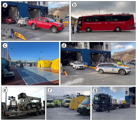
Figure 5.
One of the key actions taken by the operational structures of the Civil Protection system in response to the imminent geophysical disaster in the volcanic complex of Santorini was the deployment of additional personnel and equipment to the earthquake-affected islands. For the Hellenic Fire Service, this included the dispatch of personnel and equipment (a) [48], such as the Mobile Operational Center “Olympos” (b) and SAR teams (EMAK), which were stationed in tents within an open space (c) in Santorini, as required by strict disaster safety protocols. Patrol vehicles and personnel of the Hellenic Police (d) [49] arrived early in Santorini. Similarly, the Armed Forces deployed special vehicles and equipment (e), while health services, including the Special Department of Disaster Medicine of the National Center for Emergency Assistance (f), were also sent. Additionally, utility services, including power generators from the Hellenic Electricity Distribution Network Operator [50], were dispatched to ensure continued operations in the event of a large power outage (g).
In addition to Santorini, firefighting forces were also deployed to Amorgos, Ios, Astypalaea, and Anafi Islands located around the activated area. A helicopter with aerial rescue personnel was placed on standby on Naxos Island, while the South Aegean Regional Fire Department maintained a state of general alert.
5.2.2. Contribution of the Hellenic Police
The Thira Police Directorate was reinforced from the first days of the evolving seismic sequence (Figure 5d). In particular, the Hellenic Police Director of the Cyclades arrived in Santorini with 20 police officers, while additional personnel and vehicles were sent from Athens, the capital city of Greece, including 10 members of the Crime Prevention and Suppression Units of the Hellenic Police with three vehicles. The latter carried out sweeping checks every night on the streets and in residential areas of Santorini in order to prevent delinquent behavior, suspicious activities, and looting, which could endanger the safety of residents and visitors. These actions were imperative, as thousands of residents had fled the island for weeks in fear of a destructive earthquake, leaving homes, accommodation, shops, and property vacant for many days and weeks. In addition, the strong presence helped to stimulate a sense of security among citizens in an evolving emergency.
5.2.3. Contribution of the Port Authorities
The Port Authority of Thera implemented emergency precautionary measures at the ports within the Santorini Caldera (Athinios, Fira, Armeni, Ammoudi, and Korfos Ports) in response to the ongoing seismic sequence, aiming to ensure the safety of visitors and passengers. These measures included the restriction of access to the ports, a ban on entering vessels, vehicle management protocols, and safe mooring procedures. Administrative and criminal sanctions were established for non-compliance. Specifically, access to the port of Athinios was restricted, except during the arrival and departure times of large ships carrying passengers and vehicles. Access to the other ports in the Santorini Caldera (Fira in the northeastern part, Armeni and Ammoudi in the northern part, and Korfos Thirassia in the northwestern part) was also restricted.
Regarding the docking of vessels, the approach of ships, boats, and floating structures to the designated ports was prohibited, unless there was an urgent need and only with the approval of the port authorities. Concerning safe mooring, the owners and captains of vessels were instructed to take measures for secure anchoring in order to protect their ships from seismic events and related vibrations. As for immediate evacuation, owners of small boats, fishing vessels, and commercial recreational craft were instructed to remain on continuous alert and in increased preparedness for responding not only to the evolving seismic sequence but also to extreme hydrometeorological phenomena.
5.2.4. Contribution of the Hellenic Armed Forces
The Hellenic Armed Forces were on standby to intervene immediately if conditions required it. As a precautionary measure, they deployed a trailer equipped with a high-lifting capacity crane (Figure 5e), a large lighting column to illuminate a specific area, a substantial number of tents for temporary accommodation, and two portable kitchens, all accompanied by personnel from the Directorate of Construction–Natural Disaster Management of the Hellenic National Defense General Staff. Additionally, two staff members were sent as liaison officers for coordination between the Hellenic Armed Forces and the other involved authorities and operational structures.
Additionally, a tank landing ship was stationed at the port of Ios Island, located north of the earthquake sequence, ready for immediate departure, ensuring an extremely short response time given its proximity to Santorini. Furthermore, a general support vessel, equipped with substantial operational capabilities to manage emergency situations, was on standby at the naval station of Salamina Island, located in the Region of Attica.
5.3. Strengthening Health Services in Earthquake-Affected Islands
All leaves of medical, nursing, and other staff at the Santorini Hospital were urgently and strictly revoked. At the same time, as part of the continuous operational readiness and preventive strengthening of immediate response mechanisms, the National Center for Emergency Assistance (NCEA; ΕΚΑΒ in Greek), as an operational part of the MCCCP, proceeded with targeted reinforcement of its personnel on Santorini, Amorgos, and Ios Islands.
The staff of the NCEA in Santorini, Amorgos, and Ios were reinforced with a team from the Special Department of Disaster Medicine (ETIK in Greek), comprising a doctor, rescuers with the necessary medical equipment, and additional rescue personnel and ambulances (Figure 5f). Simultaneously, the Health Operations Center (KEPY in Greek) and the Unified Coordination Operations Center (ESKE in Greek) maintained increased operational preparedness to ensure continuous coordination and an immediate response to the needs of the affected population.
The administration of the Second Health Region of Piraeus and the Aegean ensured increased preparedness for emergency response in the event of a destructive earthquake, including the reinforcement of staff at the Santorini Hospital as well as public health facilities in Amorgos and Ios Islands. This included the deployment of two teams of doctors and nurses from the Emergency Departments of the “Attikon” General University Hospital in Haidari (Attica region) and the General Hospital–Health Center of Naxos Island, along with a specialized psychological support team from the “Dafni” Psychiatric Hospital of Attica. In such an event, the mobilization of all private doctors across the three islands was also planned.
In the context of nationwide operational planning and the assessment of hospital staff readiness, emergency response, and crisis management, operational exercises have been implemented across numerous hospitals in Greece. These exercises aim to optimize coordination mainly with the operational structures of Civil Protection, particularly with the Fire Service, and form part of a strategic program initiated and intensified recently by the Ministry of Health. Each hospital has developed detailed contingency plans to address various types of crises. Operational exercises are conducted to evaluate staff preparedness and institutional capacity to respond effectively to emergencies. The significance attributed to these exercises is underscored by their inclusion as a performance evaluation criterion for hospital administrations. These exercises have established a framework for coordinated health-level responses to natural hazards and related disasters.
As part of the increased preparedness actions, an operational exercise was also conducted at the Thira Hospital, including evacuation of the facilities. The exercise was supervised by the Deputy Minister of Health and the Hospital Administrator, while health and Civil Protection authorities remained on high alert due to the ongoing seismic activity.
5.4. Contribution of Public Utility Services
To protect Santorini from a potential blackout in the event of a major earthquake, the Hellenic Electricity Distribution Network Operator deployed two trucks with generators to the island (Figure 5g). In collaboration with the operator, the Municipality of Santorini also took steps to strengthen the electricity supply network during the evolving seismic sequence. This effort involved reinforcing the existing infrastructure and adding additional poles and conductors at strategic locations across the island. These measures aim to minimize the risk of power outages, enhance the resilience of the network against strong ground motion, and prevent a widespread blackout.
In addition, the Ministry of Digital Governance, in cooperation with mobile telephony and satellite systems and communications service providers, arranged for the installation of mobile units and generators on Santorini, Anafi, Amorgos, and Ios Islands, which were affected by the seismic sequence and the related geohazards. The aim was to ensure that telecommunications would remain uninterrupted, even in the event of a strong earthquake and a widespread blackout.
To accommodate the increasing number of residents planning to leave Santorini due to the ongoing and intensifying seismic sequence, airlines added extra flights to and from the island. This decision was made following a request from the MCCCP. Additionally, in response to the exceptional conditions on the earthquake-affected islands, airlines offered free tickets for specific groups of the population, including children under 12 years old and teachers, both permanent and substitute. Another special offer for residents who left their homes in Santorini, whether on regular or emergency flights, was the provision of a free return ticket to the island, valid for up to 6 months, with a deadline of 20 August 2025, for those wishing to return.
Similarly, ferry companies implemented emergency services to assist both residents and visitors wishing to leave Santorini. The companies stated that if needed, they would make further adjustments to their schedules to enhance the connection between Santorini and Piraeus, the chief port of Athens and the largest port in Greece, ensuring additional support for those trying to leave the island.
5.5. Informing the Population of Earthquake-Affected Islands Through the European Emergency Number, 112
The issuance of geotargeted warnings to residents via messages by the European Emergency Number Unit (Unit 5–112) of the Unified Coordination Center for Operations and Crisis Management at the Fire Service Headquarters aims to inform citizens of potential natural hazards and raise awareness about necessary self-protection measures [19].
In the context of the January–February seismic activity, the 112 service was activated for the first time for landslides in Greece. In particular, on 3 February 2025 (12:14 p.m. local time) a message was sent to the residents of Santorini, informing them of the existing hazard and risk of landslides due to seismic activity and the prohibition of access to the coastal areas of Ammoudi and Armeni, as well as the old port of Fira on the island of Santorini, while urging residents to follow the instructions of the authorities (Figure 6a). Shortly after the first message (12:57 p.m. local time), a follow-up message was sent to the residents of Ios, Amorgos, Santorini, and Anafi, informing them of the ongoing seismic activity in the broader area and urging them to stay alert and follow the instructions of the authorities and the operational structures of the Civil Protection system (Figure 6b).
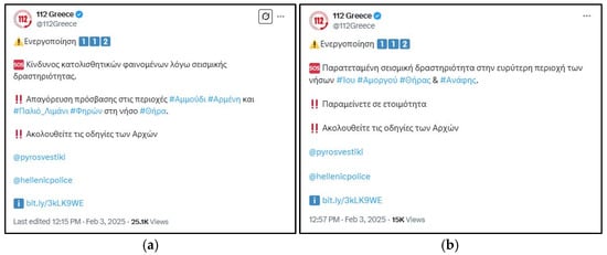
Figure 6.
The 112 messages sent (a) to the residents of Santorini informing them about the existing hazard and risk of landslides due to the ongoing seismic activity [51] and (b) to the residents of the islands of Ios, Amorgos, Santorini, and Anafi about the prolonged seismic activity and the need to follow the instructions of the authorities and the operational structures of the Civil Protection system [52]. All Greek information contained in these messages are presented in detail in the section above.
5.6. Actions of Municipal Authorities in Cooperation with Civil Protection Authorities and Operational Structures
5.6.1. Update of the Local Emergency Plan
In early February 2025, the Municipality of Thira published the second version of the local Civil Protection plan, titled “Thiras 2”, on its website [53]. This plan focuses on the organized preventive evacuation of residents at risk due to their proximity to an area threatened by an evolving or imminent natural hazard.
The most important elements of this plan published during the evolution of the early 2025 seismic sequence were the several updated thematic maps illustrating various facilities critical for rapid response and effective disaster impact management. These facilities include the emergency shelters in each of the eight sectors of the Municipality of Thira (Figure 7), the coastal embarkation points, and the zones for the airdrop of supplies and equipment in case of emergency [53].
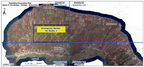
Figure 7.
Map of the northern part of Santorini (Sector 1) included in the updated local emergency plan “Thiras 2” [53] of the Municipality of Thira, which is aimed at the proactive organized evacuation of citizens at risk due to an evolving or imminent natural phenomenon. It illustrates the settlements of Oia, Ammoudi, Armeni, Finikia, Tholos, Paradisos, and Kolumbos, along with the designated emergency shelter, which is ready and accessible in case of an emergency. This shelter is located outside residential areas, away from the coastline, and far from the potential impact of a tsunami. The thick and thin red lines represent the primary and secondary road networks, respectively. Blue lines indicate the boundaries of the four sub-sectors (1.A–1.D), while the green dashed line marks the southeastern boundary of Sector 1.
The emergency shelters included in the Civil Protection plan of the Municipality of Thira were selected based on the following criteria:
- Terrain morphology: Preference for plains and open fields, avoiding ravines and residential areas;
- Proximity to existing routes: Ensuring short and safe travel from residential areas to emergency shelters;
- Evacuation routes: Access to the nearest roads leading from emergency shelters to the airport, bays, and coastal embarkation points in case an island-wide evacuation is necessary;
- Tsunami risk mitigation: Selection of locations that minimize exposure to potential tsunami threats.
The coastal embarkation points are located on the outer part of the island and not along the caldera, as it cannot accommodate large numbers of citizens and large numbers of boats or large vessels in case of an emergency. The zones for airdrops of supplies and equipment are areas that can be safely approached to supply the island with humanitarian aid in an emergency state during a disaster induced by a natural hazard (earthquake or volcanic eruption).
Another important element of the plan is the tables outlining the meeting and pick-up points for vulnerable groups and students via accredited means of transport for each community. These points, in combination with all the planned emergency response and disaster management actions, can reduce the risk for the vulnerable groups of the population of Santorini.
As part of its ongoing efforts to effectively inform residents and visitors during the early 2025 seismic sequence, the Municipality of Thira announced the location of emergency shelters for each sector through mass and social media (Figure 8a,b). These updated maps were also posted in several central sites of the residential areas of Santorini, with guidelines for safe evacuation routes and for approaching the emergency shelters. These guidelines were printed in both Greek and English (Figure 8c,d) in order to effectively inform residents and non-Greek visitors, respectively.
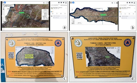
Figure 8.
Updated maps including safe evacuation routes and the locations of the emergency shelters in several sections of Santorini were posted on (a,b) social media, in particular on the Facebook profile of the Municipality of Thira, on 2 February 2025. (c,d) These maps were also posted on several central sites of the residential areas of Santorini in order to effectively and rapidly inform residents and visitors. The Santorini sectors presented in the maps are as follows: (a) Sector 5: southeastern part (Pyrgos and Megalochori areas); (b) Sector 7: southern part (Akrotiri area); (c) Sector 1: northern part (Oia area); (d) Sector 3: northwestern part (Fira area).
5.6.2. Dissemination of Earthquake Information and Preventive Civil Protection Measures to Population
The Municipality of Thira, through the Deputy Mayor responsible for Civil Protection, consistently posted updates on social media regarding Civil Protection measures in response to ongoing seismic activity in the Santorini–Amorgos area. These updates included self-protection measures so that residents and visitors would know what to do during and after the generation of a strong earthquake if they were indoors, outdoors, or close to coastal areas after an earthquake with high potential for tsunami triggering. These measures were always aligned with the decisions and recommendations of the aforementioned permanent committees of the EPPO.
5.6.3. Pre-Seismic Inspection of Critical Infrastructures
Regarding the structural integrity of critical infrastructure in Santorini, a pre-seismic inspection of school facilities at all educational levels was conducted by teams of civil engineers from the EPPO and the Technical Chamber of Greece. The primary objective was to ensure that all school buildings met safety standards and were suitable for accommodating students and staff upon their return after the completion of the seismic sequence.
5.6.4. Installation of Warning Signs and Restriction of Access to Vulnerable Areas
During the earthquake sequence, landslides were generated, mainly in Santorini and secondarily in Amorgos, leading to minor impact on the natural and built environment, such as debris accumulation at the foot of the slopes and on parts of the road network. However, there were no significant impacts on buildings, infrastructure, or the local population. In response, municipal authorities, in coordination with Civil Protection authorities and operational structures, promptly placed warning signs to restrict access to areas susceptible to landslides. A similar approach was applied to the access to old, abandoned masonry buildings that are structurally unstable and are located within residential areas. These buildings were marked to keep people at a safe distance.
5.7. Declaration of the Affected Islands in an Emergency State and Measures for Supporting the Local Economy
The MCCCP declared a State of Emergency in Civil Protection for the Municipalities of Thira, Amorgos, Anafi, and Ios in the South Aegean Region. The state of emergency was declared to last from 1 February to 3 March for Santorini [54]; from 11 February to 11 March for Amorgos [55]; from 13 February to 13 March for Anafi [56]; and from 14 February to 14 March for Ios [57]. For Santorini, in particular, the state of emergency was extended by one month, until 3 April 2025 [58]. This measure was primarily taken to facilitate the bypassing of bureaucratic procedures in public administration to ensure a more efficient response to the seismic crisis.
Following the declaration of a State of Emergency for the affected municipalities due to recent seismic activity, the Ministry of Labor and Social Security advanced special measures to preserve employment and support the local economy [59]. Specifically, private sector enterprises within the Municipality of Thira were permitted to suspend employment contracts from 1 February to 3 March 2025, with a simultaneous prohibition on dismissals and an obligation to maintain employment positions for an equal period after the suspension ended. At the same time, employees under suspension were entitled to special purpose compensation, full social insurance coverage, and proportional holiday bonuses, with the related expense covered by the state budget. The declaration submission processes were carried out through the respective available digital platforms.
5.8. Ministerial Decisions on the Mitigation of the Impact of Earthquakes and Risk Reduction
Increased preparedness actions were implemented on Thira and Thirassia Islands to mitigate the impact of earthquakes and related hazards, such as landslides, while ensuring the safety of residents, visitors, and workers. These measures were outlined in a ministerial decision [60] and signed by the MCCCP among other key ministries. The temporary restrictions, which were in effect from 14 March to 14 May 2025, were applied to areas close to landslide zones and locations at high risk due to the attraction of large numbers of visitors throughout the year, including the Athinios Port, the old port of Fira Town and the coastal settlements of Ammoudi and Armeni (Figure 9). This ministerial decision was updated on 13 May 2025 with similar measures put in place until 15 November of the same year [61].
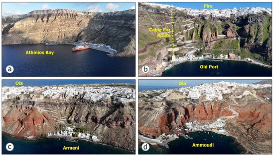
Figure 9.
Restrictions on access and staying were issued for areas with high landslide risk in Santorini, including (a) Athinios Port and the upslope road network, (b) the old port of Fira Town and the Santorini Cable Car route, as well as the (c) Armeni and (d) Ammoudi settlements, downslope of Oia Village.
These measures are generally classified into the following categories of temporary measures:
- Restriction of access to and presence in ports, their adjacent areas, and surrounding offshore zones, unless specifically authorized by port authorities;
- Restriction of access to and movement on certain parts of the road network and footpaths;
- Restriction of access to designated zones within settlements (Figure 10);
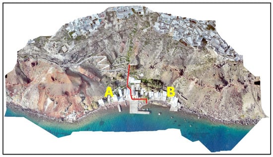 Figure 10. Map of the Armeni coastal settlement included in the Joint Ministerial Decision on Emergency Civil Protection Measures for the Santorini Island Complex published on 14 March 2025 [60]. In Area B, the use of residential buildings, hotels, short- and long-term rentals, and healthcare facilities has been temporarily suspended due to the increased landslide hazard, including rockfalls and slides, and related risks. Sea access by any vessel or craft was permitted only with prior permission from the port authorities.
 - Suspension of operations for residential buildings, hotels, and healthcare facilities in affected areas;
- Prohibition of all vehicle traffic in specific sections of the road network.
5.9. Activities of Volunteer Teams for the General Population and Vulnerable Groups
In Greece, the mobilization of Civil Protection volunteer teams in emergencies is governed by a formal institutional framework. The principal legal basis is Law 4662/2020 [16], which delineates the organizational structure and operational procedures of the Civil Protection mechanism, including provisions for volunteer engagement and the implementation of corresponding action plans. Pursuant to Article 62 of the aforementioned law, volunteer organizations included in the Register of Volunteer Organizations for Civil Protection may be officially mobilized and assist the involved authorities during emergencies. This mobilization is executed in accordance with pre-established operational plans and memoranda of understanding determined by the competent authorities and operational structures.
In the case of the early 2025 Santorini–Amorgos earthquake swarm, the contribution of volunteers was also crucial. Among the first volunteer groups mobilized was the Hellenic Red Cross (HRC) (Figure 11), which deployed special teams to Santorini [62]. Specifically, a multi-member team of Samaritan–Rescuers from the SAR Team of the HRC, along with a team of social workers and psychologists, arrived on the island to provide psychosocial support to residents distressed by the repeated tremors. The teams were equipped with rescue vehicles, operational tools (e.g., cutters, rescue ropes etc.), and two specially trained rescue dogs from the Canine SAR Team (K9) of the HRC.
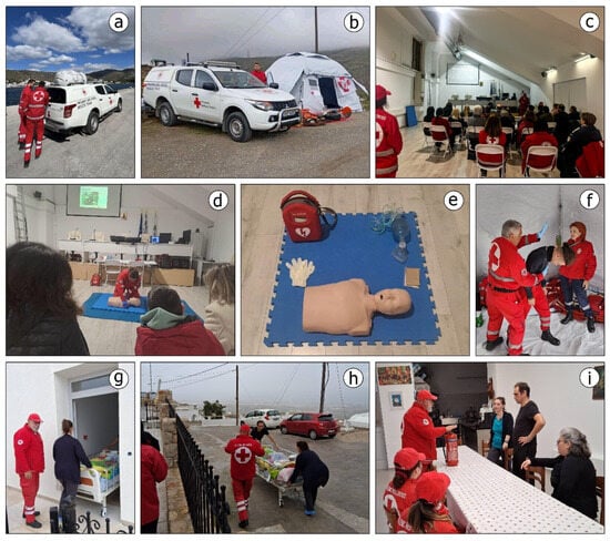
Figure 11.
The contribution of volunteer groups in managing the seismic crisis on the affected islands was significant. In particular, the HRC sent teams of well-trained staff and fully equipped vehicles to Santorini and Amorgos Islands (a,b). Among their key activities, they provided first aid and mental health first aid courses (c–f) for the general population and vulnerable groups. They also conducted an evacuation exercise of an elderly care center (g–i), aimed at training and informing the elderly and staff on how to protect themselves and effectively respond in the case of a strong earthquake. The photos are from public posts by the HRC [62] in February 2025 regarding increased preparedness actions and activities implemented from 6 February to 4 March 2025 on the affected Islands in the southern part of the Aegean Sea.
The Psychosocial Health Team, which consisted of trained social workers and volunteers, with the support of the Regional Section of the HRC, assessed the island’s needs as soon as they arrived in Santorini. From the first day, they conducted home visits to vulnerable social groups, including the elderly (especially those living alone), the chronically ill, the disabled, and their caregivers. Their goal was to provide psychological support and guidance to help them cope with the distressing situation. According to the Psychosocial Health Clinic, the primary concern among these vulnerable groups was not knowing who to contact in case of an emergency or how to reach a safe location in general or an emergency shelter in particular. Volunteers from the HRC provided accurate information, reassurance, and emotional support through counseling sessions.
Sixty families in Thira and Thirassia Islands received much-needed psychosocial support. During their time in Santorini, the Psychosocial Health Team of the HRC conducted mental health first aid courses to equip citizens with the skills to assist themselves, their families, and others in need. These courses were held in various communities across the island in collaboration with the municipal authorities, Civil Protection authorities, and local security forces, with significant participation from residents. A total of 198 people were trained in essential skills to help them manage the challenges posed by the ongoing earthquake sequence. Although no major earthquake with severe impact occurred, the first aid courses, mental health training, and home visits to vulnerable groups proved invaluable in strengthening community preparedness and resilience.
An additional action carried out by the Volunteer Samaritans–Rescuers Group of the HRC was the evacuation exercise of the Elderly Care Center in Santorini. The main objective of the exercise was to train and inform the elderly and staff about the appropriate protection and response measures in case of a strong earthquake. During the exercise, the Volunteer Samaritans–Rescuers simulated immediate response procedures, including the evacuation of the facilities, first aid and crisis management, and ensuring the smooth transportation and care of the elderly. At the same time, social workers–psychologists, with the support of social welfare volunteers, provided psychosocial support before, during, and after the exercise to the staff, the elderly, and their guests.
Similar actions were carried out in Amorgos, where a team of Volunteer Samaritans–Rescuers from the special SAR team and a team of social workers–psychologists and social welfare volunteers were deployed by the HRC to assess the situation as the seismic sequence continued to intensify. As in Santorini, their goal on this island was to collaborate with local authorities and operational structures of the Civil Protection system, assess needs, and provide psychosocial support to the population across the island.
On Amorgos Island, the team of Volunteer Samaritans–Rescuers and Lifeguards from the HRC established a temporary operation center in the area of Aegiali, which was in constant readiness. Additionally, in cooperation with the municipal and the Civil Protection authorities, they implemented awareness-raising activities for school students to prepare them to respond in case of a strong earthquake.
5.10. Web Platform for Safe Emergency Shelters
In the midst of the evolving earthquake sequence, the Ministry of Digital Governance announced the launch of a new web platform for safe emergency shelters [63] (Figure 12), which is a tool to inform and guide citizens about assembly points in case of earthquakes and other disasters induced by natural hazards. This web platform was implemented by the National Observatory of Athens under the supervision of the Ministry of Digital Governance. Through this initiative, citizens can identify safe assembly points all over Greece, including the islands affected by the early 2025 seismic sequence (Santorini, Amorgos, Anafi, and Ios Islands). The web platform for safe assembly points is designed in such a way that it ensures (i) easy access for users, as the service is available online, without the need to install an application, (ii) the provision of real-time information, including all approved assembly points, and (iii) gradual updates and enrichment, with additional guidance and information material for different categories of disasters induced by natural hazards.
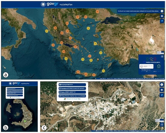
Figure 12.
Views from the web platform of the Ministry of Digital Governance [63], which provides information and guidance to the population about assembly points in case of earthquakes and other disasters induced by natural hazards. It includes assembly points across Greece (a), including those on the earthquake-affected islands of Santorini, Ios, and Amorgos. The assembly points of Santorini (b) are located far from the coastline, ensuring protection from potential tsunamis. (c) On Chora, the capital town of Amorgos Island, the assembly points are situated on the eastern and western boundaries of the residential area. Each site is marked with a pop-up table displaying its code, name, region, and municipality (b,c) (blue fields on the white polygons).
An assessment of emergency site suitability in relation to coastal zone vulnerability to tsunami impacts and inundation areas revealed that current site selection has largely followed a single-hazard approach. This method considers earthquakes as isolated events, without accounting for associated hazards or interactions with other factors. However, applying a multi-hazard perspective, recognizing that earthquakes can trigger primary and secondary effects and interact with both natural and built environments, shows that many designated assembly points in the coastal areas of the southern part of the Aegean Sea fall within tsunami inundation zones. This finding is supported by run-up data from southern Aegean events that have already been reported and recorded on the islands of the southern part of the Aegean Sea [37] that were affected by the early 2025 Santorini–Amorgos earthquake swarm. Consequently, the spatial distribution of emergency sites requires reevaluation to mitigate compounded risks. Failing to account for hazard interactions could exacerbate the impacts across multiple sectors and prolong response and recovery times.
A multi-hazard approach has already been implemented in the Region of Attica (central Greece), where designated emergency shelters, including assembly points and earthquake camps, were reassessed for suitability [64]. This approach considered the existence of areas that are susceptible to earthquake-related hazards, such as landslides, liquefaction, and tsunamis. As a result, emergency shelters located near landslide-prone slopes, within liquefaction-susceptible zones, or in coastal areas that are at risk of future tsunami inundation were excluded from the final catalog of the emergency shelters [64].
6. Previous Crises in the Santorini Volcanic Complex and Increased Preparedness in Anticipation of an Imminent Disaster
Between January 2011 and March 2013, Santorini experienced its first earthquake–volcanic unrest since the eruption of 1950, as recorded by permanent monitoring networks and numerous temporary measurements. This period of activity was marked by shifts in key parameters, including seismic activity, topographic deformation, thermal conditions, and changes in the chemistry of hot fluids and soil gases [65]. Field measurements also detected variations in soil gas flux and composition [66,67]. Observations from Global Positioning System (GPS) networks [68] and satellite radar detected ground uplift on parts of the Kameni Islands, reaching rates of nearly 1 cm per month [69,70,71,72], with possibly higher but undetermined offshore uplift. These changes exceeded the baseline levels established for the Kameni volcanic center over the previous two decades. By spring 2012, monitoring data indicated that the volcano had returned to its prior background state, a conclusion that was confirmed by geodetic measurements [70,73].
In February 2012, about 13 months into the crisis in Santorini, an 18-member Special Scientific Committee for Monitoring the Santorini Volcano was established following an initiative by the EPPO and a decision by the Deputy Minister of Infrastructure, Transport, and Networks at the time [74]. The committee was given a two-year mandate and included distinguished scientists such as geologists, volcanologists, seismologists, and engineers from government ministries, universities, research institutes, and centers [74].
The role of the committee was as follows [74]:
- the continuous monitoring and evaluation of scientific data related to the activity of the Santorini volcano;
- the immediate consultation with and recommendation to the EPPO regarding protection measures;
- recommendation to the EPPO regarding actions to maintain the continuous operation of scientific equipment and monitoring instruments, ensuring the collection of necessary data for volcanic activity monitoring.
During its two-year term, the committee held ten meetings to discuss Santorini’s seismic and volcanic activity and financial matters (funding, instrument purchase and maintenance, and travel) and make critical decisions. Key actions included the establishment of four subcommittees for seismology, deformation monitoring, physico-chemical monitoring, and civil protection in order to support the committee’s activities, foster advisory cooperation with foreign scientists, and reach a final conclusion on the volcano’s reactivation scenarios and proposed protection measures. The committee also regularly issued briefing notes to political leaders on the phenomenon’s evolution and final activation scenarios [75].
In June 2013, the members of the Civil Protection Subcommittee drafted the final report on volcanic hazard management titled “Reactivation Scenarios and Volcanic Hazard Assessment of the Santorini Volcanic Complex”, which was submitted to the GSCP. The report considered two reactivation scenarios: (i) an extreme scenario involving a sub-plinian eruption, and (ii) a more probable scenario involving the intra-caldera reactivation of the Kameni volcanic centers. It analyzed all hazards, precursors, affected areas, potential impacts on the population and infrastructure, and proposed mitigation measures. Following this report, the Ministry of Health, the Ministry of Rural Development, the National Health Operations Center, the Public Power Corporation, the Hellenic Electricity Distribution Network Operator, the Hellenic Civil Aviation Authority, and the General Secretariat for Public Revenue requested further details on the document, particularly regarding the identification of potential impacts on the population and infrastructure and the proposed mitigation measures. The requested responses were completed by October 2014.
This final report served as the basis of the first version of the General Plan for Emergency Response and Immediate/Short-term Management of the Impact of Volcanic Activity in the Santorini Volcanic Complex, code-named “Talos” [30], and its update [76]. It is worth noting that the Special Scientific Committee for Monitoring the Santorini Volcano, initially established in February 2012, was replaced by the Permanent Scientific Committee for Monitoring the Aegean Volcanic Arc of EPPO, with an expanded mandate to monitor and analyze hazards and risks for all volcanic centers of the Aegean Volcanic Arc [75].
It should be clarified that the hazard and risk analysis, as well as the reactivation scenarios, focused only on the Santorini volcanic complex. However, the potential impacts on the population and infrastructure are not limited to this area. The proposed mitigation measures, emergency response actions, and short-term management strategies also apply to volcanic activity from other centers. This includes any of the centers of the Hellenic Volcanic Arc located in the southern Aegean Sea.
7. Discussion
7.1. Comparison of 2011–2012 and 2025 Seismic Crisis Management
The planning for the early 2025 seismic sequence and the related actions for increased preparedness in anticipation of an imminent hazard, whether an earthquake or volcanic activity, cannot be compared to what was in place at the start of the 2011–2012 crisis. In 2011, the emergency and disaster management plans for earthquakes and volcanic eruptions did not exist in the form of the Enceladus and Talos plans. Thus, the related actions of the authorities and operational structures of the Civil Protection system were not strictly defined.
However, the common element in both cases is the emphasis on raising awareness and educating the population and specific groups, such as students and teachers. In 2011, local authorities responded promptly and remained in continuous readiness, providing support at all stages of managing the event. Timely and rational communication with the public was a central aspect of the management strategy, aimed at reducing uncertainty and ensuring social cohesion. This process was implemented in collaboration with the educational community and local authorities through targeted actions, such as presentations, informational events, and interactive programs. Special emphasis was placed on raising awareness among students and teachers to enhance the dissemination of information and the development of proper community response practices. Despite the presence of unconfirmed information and rumors, the residents’ response was characterized by calmness, responsibility, and adaptability, factors that contributed to the effective management of the situation.
7.2. Adequacy of Implemented Measures During the Early 2025 Seismic Sequence
A key component of increased preparedness is enhancing community involvement. Strengthening the community is essential, as participatory activities like operational exercises improve preparedness and raise awareness of seismic risks [77]. These activities play a crucial role in educating residents on proper emergency responses, helping to minimize inappropriate actions during a real earthquake, as previous research has shown that Civil Protection experiences lead to more effective responses [78]. This engagement not only boosts preparedness but also reinforces social bonds, which are vital in times of disaster induced by natural hazards.
Moreover, Civil Protection authorities should prioritize education and awareness campaigns focusing on seismic risks and preparedness strategies [15]. Global comparisons show that residents’ preparedness levels differ widely across cultural contexts, meaning that authorities need to tailor their efforts to effectively address these cultural variations [79]. Training programs and resources designed for local communities can improve practical preparedness actions, leading to a reduction in vulnerability [80]. Research suggests that increasing residents’ perceived sense of risk is strongly linked to increased preparedness actions, indicating that Civil Protection authorities should improve communications about risk perception [81].
In the case of Santorini, the increased preparedness actions of the authorities and operational structures of the Civil Protection system did not significantly involve the participation of residents and visitors. Although actions were taken to increase preparedness in anticipation of a strong earthquake and to improve the safety of residents and visitors, such as pre-seismic inspections of the critical infrastructure, continuous updates on seismic activity, and the announcement and implementation of measures to reduce risks from earthquakes and associated geohazards, no extensive actions involving the population were carried out by the authorities and operational structures of the Civil Protection of Greece.
This specific need was largely covered by volunteer teams, such as the HRC. Equipped with specialized personnel and the necessary resources, these teams reached out to both the general population and vulnerable groups on Santorini and Amorgos Islands, providing first aid and mental health first aid courses, psychosocial support, and home visits to inform the public and vulnerable groups, with a particular focus on people with disabilities and the elderly, among others. These initiatives contributed to strengthening social resilience against seismic risk, complementing the preparedness actions of institutional authorities in anticipation of a strong and destructive earthquake.
When improving urban infrastructure and risk management systems, it is essential for authorities to carry out comprehensive evaluations of existing infrastructures to ensure that they are resilient to seismic events. By assessing the seismic resistance of buildings and adjusting design standards when necessary, Civil Protection authorities can greatly minimize the potential damage and losses from earthquakes. Moreover, working with property owners to encourage seismic retrofitting measures can play a key role in enhancing overall community safety [82].
In the case of the seismic activity in Santorini and Amorgos, pre-seismic assessments were conducted not only on the resilience of critical infrastructure (such as school complexes, healthcare facilities, etc.) but also on the preparedness of their personnel. This involved the implementation of operational exercises during the ongoing seismic sequence, which, among other actions, included the immediate evacuation of these facilities in response to the earthquake.
The incorporation of ecological, physical, and psychological preparedness strategies is crucial, as evidenced by the interventions carried out in the earthquake-affected regions of Santorini and Amorgos Islands, as well as those highlighted in related studies [83,84]. These efforts showcase the diverse approach required for effective preparedness initiatives aimed at enhancing community resilience to natural hazards.
Individual psychological preparedness is also crucial. Studies have shown that mental preparedness supports physical preparedness and can greatly influence community responses during disasters [84]. As a result, training and educational programs have been developed to enhance both physical and psychological resilience, highlighting the importance of a holistic approach to disaster preparedness [83].
Moreover, emergency plans include various specific measures to boost readiness. For example, Joffé et al. [85] highlighted that disaster preparedness involves physical actions like securing heavy items, retrofitting structures, and ensuring that emergency supply kits are available. These steps are essential for households to reduce risk during disasters induced by natural hazards.
In the case of increased preparedness in anticipation of an imminent earthquake in the Santorini–Amorgos area, such physical and psychological measures were proposed to the residents either through announcements in the mass and social media by the authorities involved or through in-person mental health first aid courses and visits to vulnerable members of the population in the earthquake affected area, carried out by specialized personnel.
Since the seismic swarm occurred during the winter season (February), tourist activity was significantly lower compared to that in the summer period (May to September). During the summer months, Santorini experiences exceptionally high tourist volumes, being one of the most popular destinations in Greece and worldwide. Tourist traffic peaks between June and August, with several thousand visitors arriving daily. High-density areas, such as Oia, Fira, and the island’s renowned beaches, attract large crowds, placing considerable pressure on local infrastructure and essential services. The substantial presence of tourists during the high season necessitates the continual revision, reinforcement, and adaptation of emergency preparedness and disaster response plans. The implemented increased preparedness actions during the early 2025 Santorini-Amorgos seismic crisis were essential to ensure that both residents and visitors would be well-informed, sufficiently prepared, and capable of responding effectively to seismic and other geohazards.
Notably, the increased preparedness actions implemented aimed to directly inform the general public, including international visitors unfamiliar with the island’s natural hazards and the Greek language. For example, information dissemination initiatives undertaken by the relevant authorities and operational Civil Protection structures, including social media posts featuring maps of emergency shelters and designated evacuation routes, as well as physical signage placed in strategic locations across populated areas, were also prepared and provided in English to ensure accessibility and comprehension for non-Greek-speaking visitors.
Taking into account the aforementioned findings, it is clear that enhancing preparedness in seismically active areas requires a comprehensive strategy from Civil Protection authorities. This includes fostering community engagement, implementing effective risk communication, promoting educational initiatives, and conducting detailed infrastructure assessments. Through these diverse efforts, authorities can strengthen community resilience, ensuring that residents are adequately prepared and capable of responding efficiently to seismic hazards.
7.3. Similarities, Differences, and Shared Lessons of Increased Preparedness in Santorini–Amorgos Among Recent Cases: The 2024–2025 Ethiopia Seismic Swarms and the Highly Anticipated Istanbul (Turkey) Earthquake
A similar case to that of the southern Aegean occurred in central Ethiopia, in particular in the Fentale volcanic complex in the main Ethiopian Rift. This region was affected by two earthquake swarms: the first one from 27 September 2024 to 2 November of the same year, with 17 earthquakes of magnitudes larger than Mw = 4.0, and the second from 21 December 2024 to 31 March 2025, with over 300 earthquakes of magnitudes larger than Mw = 4.0 [86,87,88,89,90,91]. The recent earthquakes in Ethiopia’s Afar region have severely disrupted the lives of pastoralist and semi-pastoralist communities, displacing over 85,000 people and damaging critical infrastructure, including homes, schools, roads, irrigation farmlands, and health facilities, leaving communities without adequate access to food, education, and medical services [92,93].
In response to the evolution of the seismic sequence, the impact on the natural and built environments and the increased risk of potential destructive earthquakes and volcanic eruptions in central Ethiopia, a range of increased preparedness actions in anticipation of an imminent disaster were implemented by the involved authorities [94,95,96,97,98]. Despite these efforts, multiple challenges emerged related to the urgent needs across multiple sectors, including agriculture, camp coordination and camp management, education, emergency shelter and non-food items, the provision of food, health, and nutrition services, the protection of vulnerable groups, and sanitation and hygiene [94,95,96,97,98].
To enhance health preparedness, mobile and satellite clinics provided curative and preventive services with referral pathways, while health kits were distributed and outreach was conducted through coordinated mobile teams. However, critical shortages of staff, medicines, diagnostic tools, and infrastructure, along with limited accommodations, restricted services to daytime hours and left nighttime emergency care largely unaddressed.
Rapid nutritional screening and emergency feeding for severely malnourished children and pregnant/lactating women were launched, supported by mobile health teams and education on infant feeding practices [95]. Nevertheless, the absence of on-site stabilization centers, limited supplies for moderate cases, and poor living conditions (overcrowding, poor sanitation, and limited maternal support) hindered the effectiveness of these interventions and increased malnutrition risks.
The authorities implemented digital registration and vulnerability-based targeting to enhance fairness and efficiency in food distribution, dispatching emergency supplies quickly and aligning efforts with population needs. Nonetheless, limited food stocks, transport delays, inadequate storage, data gaps, market disruptions, and the lack of grinding mills hindered timely and effective access to food.
Community engagement was initiated through consultations with local leaders, protection desks, feedback systems, and awareness activities to support vulnerable individuals and promote equitable service access. However, the exclusion of some vulnerable groups, inconsistent data, weak monitoring, and instances of discrimination limited the effectiveness and inclusivity of protection efforts.
Water trucking, storage tank installation, hygiene item distribution, and hygiene promotion campaigns were prioritized, with water, sanitation, and hygiene (WASH) partners mobilized for rapid assessments and supply delivery. Nevertheless, high demand, poorly designed infrastructure, damaged or missing latrines, and inadequate sanitation facilities with no lighting or security increased health and gender-based violence (GBV) risks.
Temporary learning spaces were established in camps, supplies were distributed, and teachers were trained in psychosocial support, with coordination among education partners aiding resource sharing. Nonetheless, damaged schools, a lack of child-friendly latrines, teacher shortages, and logistical challenges slowed education resumption and led to rising dropout rates, particularly among girls.
Emergency shelter kits and household items were distributed based on needs assessments, with locally informed shelter designs and a phased approach from emergency to transitional housing. However, over half of displaced families lacked adequate shelter, with makeshift dwellings, insufficient supplies, and poor privacy exposing them to environmental and social risks.
Basic camp structures and leadership committees were established to enhance coordination, support self-governance, and involve communities in site planning and service management. A unified coordination hub and service mapping aimed to reduce duplication and improve coverage. However, the lack of an initial formal coordination system, poorly planned and congested camps, limited access, weak communication infrastructure, and logistical challenges hindered effective aid delivery and timely service adjustments.
The increased preparedness actions implemented in Ethiopia and Greece offer insightful contrasts and shared lessons in disaster preparedness and response. Both cases demonstrate the growing importance of multi-sectoral coordination, risk communication, and inclusive strategies to address community vulnerabilities.
A key similarity in both cases lies in the implementation of multi-agency coordination. In Ethiopia, humanitarian response was led through a range of sectors, including health, nutrition, WASH, education, and protection, involving government bodies, non-governmental organizations (NGO), and United Nations (UN) agencies. Similarly, in Greece, a well-established Civil Protection system mobilized security forces, health authorities, public utility services, and regional and local authorities under national contingency and local emergency plans. Both countries emphasized the need to secure infrastructure and ensure operational continuity through pre-event structural inspections, particularly in schools, health centers, and shelters. Public communication also played a central role: in Ethiopia, messaging focused on WASH practices and the awareness of malnutrition and protection risks, while in Greece, public broadcasts, 112 emergency alerts, and targeted awareness-raising and training initiatives were deployed to inform and prepare residents and visitors alike.
In both countries, vulnerable populations, such as women, children, the elderly, and persons with disabilities, received focused attention. Ethiopia integrated nutrition and psychosocial services into internally displaced persons’ (IDP) camps, while Greece mobilized specialized teams of the security forces and volunteers, including SAR teams, disaster medicine teams, and mental health professionals, to support affected individuals. Emergency health systems were strengthened in both settings, with mobile clinics and additional personnel introduced to meet increased demand and ensure the coverage of remote or displaced populations. Notably, where institutional efforts fell short, community volunteers and local actors helped bridge the gap, offering critical services and enhancing resilience on the ground.
However, the two cases also differed markedly in their approaches and outcomes. Greece benefited from robust legal frameworks, such as the “Enceladus” and “Talos” emergency response and disaster management general plans and their updates, which enabled rapid mobilization and predefined responsibilities. In contrast, Ethiopia’s emergency management relied more heavily on partner coordination and lacked structured, codified protocols at the local level.
Technological readiness further differed between the two responses. Greece utilized high-tech solutions, including UAS, mobile operations centers with modern and innovative technology, and public alert systems, while Ethiopia faced widespread disruptions to electricity, telecommunications, and water infrastructure, limiting the deployment of such tools. Shelter and site management in Ethiopia was improvised and often inadequate for the displaced populations, whereas Greece pre-identified and mapped evacuation routes and emergency shelters, incorporating terrain analysis and tsunami risk in their selection.
Common challenges emerged in both contexts, such as the difficulty of sustaining essential services during crises, limited community engagement in formal preparedness efforts, and the vulnerability of critical infrastructure. While Ethiopia struggled with unregistered displaced populations, fragmented service delivery, and delayed coordination, Greece faced the challenge of managing a protracted period of heightened seismic threat without triggering public panic or response fatigue. In both cases, the need for psychological support and consistent communication was evident but often underprioritized.
From these cases, several shared lessons emerge. Both cases affirm that preparedness is vital for reducing casualties and ensuring more organized response, relief, and recovery efforts. The importance of legal and institutional readiness is underscored by Greece’s relatively structured and streamlined implementation. Equally, both contexts highlight the need for inclusive, community-based approaches to preparedness and response. Engagement with local populations not only enhances the reach and relevance of interventions but also builds long-term resilience.
Moreover, both responses demonstrate the value of multi-dimensional risk management that addresses physical safety, psychological well-being, and infrastructure security concurrently. Flexibility and adaptability remain essential: Ethiopia’s mobile clinics and Greece’s mobile command centers reflect the necessity of systems that can operate under dynamic and evolving conditions. Finally, both countries showed that public trust, fostered through accurate and timely information, is essential in securing community cooperation and preventing the spread of misinformation.
In summary, the Ethiopia and Greece earthquake cases converge on the fundamental principle that disaster resilience depends on early action, inclusive planning, and coordinated, flexible systems that respond not only to physical hazards but to the human and social dimensions of crises. These shared insights offer a valuable foundation for improving global earthquake preparedness and risk reduction strategies.
A relatively similar case that could be considered for comparison with the Greece and Ethiopia cases is the long-awaited large earthquake with high potential to adversely impact the city. After the Mw = 7.6 İzmit earthquake was generated in northwestern Turkey on 17 August 1999, the Governorship of Istanbul launched a comprehensive disaster risk reduction initiative in 2005, with support from the WBG and the Global Facility for Disaster Reduction and Recovery (GFDRR), to help the city prepare for and respond to earthquakes. The objectives of the Istanbul Seismic Risk Mitigation and Emergency Preparedness Project (ISMEP) included the development of the institutional and technical capacity in disaster management, the preparation of the public for disasters and emergencies, awareness-raising actions, inspections of prioritized public buildings, and the implementation of reinforcement and reconstruction activities, among other significant actions [99].
Up to 18 April 2025, public buildings built before 1999 have been made earthquake-resistant via retrofitting or reconstructing in the frame of the ISMEP [100]. More specifically, retrofitting and reconstruction were completed in more than 1590 public buildings, representing a significant portion of pre-2000 public buildings in Istanbul that were identified as vulnerable to potential earthquakes [100]. More specifically, these buildings included 1180 schools and school campuses encompassing 1386 buildings, 57 administrative buildings, 39 dormitories, and 23 social service buildings. Four large city hospitals in Istanbul with more than 1000-bed capacities were reinforced with seismic isolators to ensure uninterrupted service during earthquakes. Furthermore, emergency coordination centers covering the European and Anatolian sides of Istanbul were also constructed, and 1.8 million people were trained on emergency preparedness and response [100].
Furthermore, the Directorate of Earthquake and Ground Research of the Istanbul Metropolitan Municipality has carried out a comprehensive series of projects from 1998 to the present [101], aiming to understand and mitigate seismic risks in the city. These initiatives were developed in response to the persistent threat posed by the North Anatolian Fault and the likelihood of a large earthquake affecting Istanbul. Between 1998 and 2019, the Directorate focused primarily on foundational research to map the city’s vulnerability to earthquake-related hazards, including tsunamis and landslides [102,103,104,105], as well as its social vulnerability to disasters [106].
From 2020 to 2025, the Directorate’s efforts expanded toward applied preparedness and urban resilience. A pivotal development during this phase was the publication of district-based earthquake loss estimations [107], which modeled the impacts of a hypothetical M = 7.5 earthquake across all 39 districts of Istanbul. These localized assessments projected damage to buildings, casualties, and the loss of critical infrastructure, thus enabling the risk-informed prioritization of urban transformation and emergency response planning [108,109].
Another major advancement was the implementation of an earthquake rapid response and early warning system in order to detect seismic activity in real time and issue alerts to facilitate emergency coordination and reduce casualty rates [110].
Additionally, the municipality intensified efforts to raise public awareness, educate and train the population to effectively respond in case of an earthquake emergency. Training sessions, educational campaigns, and community-based preparedness initiatives were carried out across the city. These included earthquake drills, the distribution of safety guidelines, and multimedia awareness programs targeting specific groups of the population, including schools and community centers. Collectively, these efforts contributed to a more informed and engaged public, thereby improving Istanbul’s overall disaster readiness.
However, the 23 April 2025 earthquake in Istanbul exposed several critical issues in the city’s seismic preparedness, underscoring the need for immediate and comprehensive action to mitigate future risks. These issues are related to structural vulnerabilities, the response and education of the population, aftershock preparedness, infrastructure and communication challenges, and seismic risk awareness.
Based on the official announcement of the Turkish Ministry of Environment and Urbanization, the 23 April 2025 earthquake damaged over 4200 buildings [111], with 80% of the destruction occurring on Istanbul’s European side, revealing the vulnerability of older structures built before modern seismic codes. This widespread damage underscored the urgent need for thorough assessments and retrofitting to prepare buildings for future earthquakes.
The seismic event induced widespread panic among residents, leading to 359 reported injuries, many resulting from individuals jumping from buildings or sustaining injuries during evacuation attempts [111,112]. The panic underscored the necessity for clear communication strategies, as well as public education campaigns focused on earthquake preparedness and response, to reduce injury rates during such events.
The earthquake disrupted mobile network services in parts of Istanbul, impeding communication during critical moments [113]. This disruption emphasized the importance of strengthening infrastructure resilience, particularly communication networks, to ensure reliable information dissemination during emergencies.
Experts noted that the 23 April 2025 earthquake released only a fraction of the accumulated seismic energy along the North Anatolian Fault [114], indicating that a more significant earthquake could still occur. This realization has prompted calls for increased public awareness and education regarding Istanbul’s seismic risks and the importance of preparedness measures.
Addressing the revealed issues requires a multifaceted approach, including structural assessments and retrofitting, public education, infrastructure resilience, and the strict enforcement of building codes. Proactive measures taken now can significantly reduce the impact of future earthquakes on the city’s population and infrastructure.
The comparison of increased preparedness actions in the cases of the Santorini–Amrogos area (Greece), central Ethiopia, and Istanbul (Turkey) reveals both converging strategies and significant divergences, shaped by differences in institutional capacity, socioeconomic conditions, and the timing of interventions. While all three regions face high seismic risk, their responses, particularly in terms of increased preparedness, highlight varied approaches to reducing disaster impact.
In Istanbul, preparedness actions have been extensive, coordinated, and largely proactive. Triggered by long-standing warnings about large earthquakes with destructive impacts on the city, Turkish authorities have implemented structural risk assessments, urban transformation projects, building retrofitting, and the deployment of early warning systems. Critical infrastructure, such as hospitals, schools, airports, bridges, and tunnels, has been reinforced to meet seismic standards. In addition, simulation exercises, public drills, and awareness campaigns have played a key role in building public preparedness. These measures are supported by strong institutional frameworks, legal mandates, and municipal coordination mechanisms, reflecting a high-capacity response environment.
In the Santorini–Amorgos case, the Greek authorities undertook a comprehensive and timely preparedness campaign during the 2025 seismic swarm. This marked Greece’s first formal activation of increased preparedness in anticipation of an imminent earthquake. Actions included convening scientific risk committees, issuing targeted public warnings, deploying emergency response units and rescue teams, suspending vulnerable services, such as schools and ports, and reinforcing local health infrastructure. Public awareness and training activities were also implemented, although community participation remained limited. Greece’s legal and strategic frameworks, notably the “Enceladus” and “Talos” civil protection plans, provided a structured basis for pre-disaster action, even in the absence of an actual major earthquake.
In contrast, increased preparedness actions in Ethiopia were minimal. Although humanitarian actors and local authorities mobilized quickly to provide food, shelter, and emergency health services, there was no prior risk communication, public awareness campaign, or structural preparedness effort. Emergency shelter was inadequate, health services were overwhelmed, and displacement sites lacked basic WASH facilities. Coordination mechanisms were often weak, and the absence of EEWS, disaster management frameworks, or pre-positioned contingency plans left affected communities highly exposed to compound disasters and cascading impacts, including disease outbreaks and protection risks.
Despite these differences, the three cases share several important lessons. All illustrate the importance of multi-sectoral coordination, the need to prioritize vulnerable groups, and the value of early risk assessment. In both Istanbul and Santorini, preparedness actions were guided by legal frameworks and technical planning, allowing for swift institutional response. In Ethiopia, the experience emphasized the consequences of limited preparedness and underscored the urgent need to integrate disaster risk reduction into national development strategies.
7.4. Further Proposed Measures to Reduce Risk
To reduce the risk in the volcanic complex of Santorini, actions should be taken at an early stage. Continuous, real-time data collection using various methodologies, such as geophysical and seismological monitoring for seismic activity, geodetic techniques for ground deformation, geochemical analysis to track changes in volcanic gas composition and flow, and monitoring of physical and chemical changes in ground and surface water, can play a crucial role. Additionally, satellite techniques for thermal monitoring can significantly contribute to early detection. When combined with predictive models, these data enhance the ability to issue early warnings, especially in the event of a potential volcanic eruption, allowing for timely preparatory actions and increased preparedness to reduce both human and economic losses.
An important action in risk communication is the continuous and systematic training of both Civil Protection authorities and the general population. These activities may include operational exercises, which can be either discussion-based or operations-based [115]. In Greece, table-top exercises (TTEs) and full-scale exercises (FSEs) are commonly implemented [25]. These exercises should be conducted at multiple levels, engaging central administrative bodies, national agencies, regions, regional units, municipalities, and local communities [25]. This approach ensures that the authorities and the operational structures of the Civil Protection system are well-prepared, allowing them to test updated plans in practice and identify potential gaps or weaknesses before an actual crisis emerges.
The appropriate time interval between FSEs for natural hazards, including earthquakes and volcanoes, is influenced by various properties of the exercise, the area, and the population. These properties comprise the objectives of the exercise, the complexity of its scenario and incidents, the recent seismicity and volcanic activity, the potential for future seismic and volcanic events, and the recurrence intervals of destructive events, as well as the demographic properties of the assessed area. Furthermore, the interval between FSEs should consider the time needed to train personnel, upgrade infrastructure, and address any gaps identified in previous exercises.
This action becomes even more important for the volcanic complex of Santorini because since the first approval of the “Enceladus” and “Talos” plans in early 2020, no exercise of this type has been carried out in the islands affected by the early 2025 Santorini–Amorgos area. While there is no universally accepted standard for the interval at the regional level, the implementation of FSEs on a regular basis, at least annually, is often recommended.
Raising awareness and educating the population also involves organizing seminars and workshops [116], which should be held regularly, more frequently than FSEs, as they are less costly and thus easier to implement. These activities should focus on proper preparedness before, effective response during, and safety measures after natural hazards, addressing their impact on both the natural and built environments. The goal is to help the population develop and maintain a culture of safety. Additionally, these initiatives should be tailored to specific groups, such as teachers, health professionals, and volunteers, with an emphasis on vulnerable people, including students, children, the elderly, and people with disabilities.
For decades, EPPO has been working in this direction [117] to minimize the destructive effects of earthquakes. Its efforts contribute to developing and reinforcing seismic awareness and preparedness among the population through various initiatives. These include organizing training programs for teachers, delivering informational talks to students, conducting exercises in schools and workplaces, offering training for volunteers, and implementing educational programs for different population groups [117].
However, even in this direction, activity has been limited, with the last training seminar held for teachers of the Primary Education Directorate of the Cyclades Prefecture taking place eight years ago, in March 2017 [118], prior to the early 2025 seismic crisis in the Santorini–Amorgos area.
To reduce the risk of natural hazards in the Santorini volcanic complex, infrastructure supporting emergency actions should be prioritized, with a focus on the immediate and safe evacuation of the populations of areas prone to earthquakes, volcanic eruptions, and related geohazards. Existing infrastructure should also be reinforced. During the early 2025 crisis, the municipality updated its emergency plans and officially designated assembly points for the population. However, delays were observed in the planning and construction of critical island infrastructure, including safe escape routes, bypasses to alleviate traffic disruption, and emergency ports. The latter would ensure continued maritime connectivity, immediate access for SAR teams, secure food supplies, and, if necessary, the safe evacuation of the population in case of emergency, especially if issues arise at the largest ports of the island.
Pre-seismic inspections, as part of normal and increased preparedness, should be followed by prioritizing the reinforcement of public buildings (e.g., educational and health facilities) and critical infrastructure (e.g., water supply, irrigation and telecommunications networks). These structures should be adapted to the specific characteristics of the volcanic complex, the geohazards that could occur, and their potential impacts on both the natural and built environments. To achieve this aim, structural measures to mitigate risks should be designed and implemented, including those to prevent landslides and soil movement on the steep slopes of the Santorini Caldera.
8. Conclusions
From 26 January 2025, a seismic sequence occurred in the area between Santorini, Ios, and Amorgos Islands in the southern part of the Aegean Sea. By 15 February, thousands of earthquakes had been recorded, with the strongest event taking place on 10 February, with M = 5.2. The seismic activity was primarily concentrated in the sea close to Anydros Islet, located between Santorini and Amorgos. It was attributed to NE-SW striking offshore faults and was not linked to volcanic activity based on official announcements. This sequence raised significant concerns due to the unpredictability of its evolution, the triggering of landslides on the steep slopes of the Santorini Caldera, and the seismic history of the area, particularly the 1956 Amorgos earthquake, which triggered a tsunami that affected several Aegean islands.
The significance and the rarity of this seismic sequence lies not only in these questions about its evolution and its secondary effects but also in the increased preparedness and management of its adverse effects. This is the first instance in Greece in which increased preparedness actions have been implemented in anticipation of an imminent geohazard, particularly an earthquake. Given the unprecedented nature of the seismic sequence in the Santorini–Amorgos area, the implementation of these increased preparedness measures in response to a potential earthquake can be considered one of the few that have occurred to date.
The implemented increased preparedness actions included risk communication, strengthening the capacity and resources of security forces and health services on the affected islands, the activation of the European Emergency Number, 112, to alert the population, the enhancement of the resilience of critical networks and infrastructure by public utility services, the contribution of the local authorities with updates of local emergency plans, public awareness campaigns on Civil Protection measures, pre-seismic inspections of critical facilities, the declaration of a state of emergency on the affected islands, and actions by volunteer groups to assist the local authorities and support the general population, with an emphasis on vulnerable groups.
Given the actions listed above, it can be concluded that the approach taken by the authorities and operational structures of the Civil Protection system in Greece incorporated many of the actions outlined in the related scientific and operational literature, and even went beyond them. These actions were consistently adapted to the specific geological and geoenvironmental characteristics of the earthquake-affected areas in the southern part of the Aegean Sea. The comprehensive set of implemented actions, enhanced by additional seismic risk reduction measures proposed in this research, can be considered a best practice and a valuable lesson for managing similar seismic emergencies, not only within the Santorini–Amorgos volcanic complex but also in other regions worldwide with comparable geodynamic and seismotectonic properties.
The comparison of increased preparedness actions implemented in the Santorini–Amorgos area with recent and quite similar cases worldwide, including the 2024–2025 Ethiopia seismic swarms and the highly anticipated earthquake in Istanbul (Turkey), demonstrates that while seismic risk is universal, the capacity to anticipate and prepare for it varies widely. High-capacity settings, supported by legal, financial, and institutional resources, are better positioned to undertake preventive actions before disaster strikes. In contrast, low-resource environments often face the burden of response after damage has occurred. Nonetheless, each case reinforces a common principle: that effective preparedness, whether through infrastructure, planning, communication, or community resilience, is essential for reducing the human and economic cost of earthquakes.
Author Contributions
Conceptualization, S.M.; methodology, S.M. and M.M.; validation, S.M. and M.M.; formal analysis, S.M. and M.M.; investigation, S.M., M.M., A.S., A.A. and E.L.; resources, A.A. and E.L.; data curation, S.M., M.M., and A.S.; writing—original draft preparation, S.M. and M.M.; writing—review and editing, S.M. and M.M.; visualization, S.M. and E.L.; supervision, S.M., A.A. and E.L.; project administration, S.M.; funding acquisition, A.A. and E.L. All authors have read and agreed to the published version of the manuscript.
Funding
This research received no external funding.
Data Availability Statement
The original contributions presented in this study are included in the article. Further inquiries can be directed to the corresponding author.
Conflicts of Interest
The authors declare no conflict of interest.
Abbreviations
The following abbreviations are used in this manuscript:
| EEWS | Earthquake Early Warning Systems |
| EPPO | Earthquake Planning and Protection Organization |
| UNOCHA | United Nations Office for the Coordination of Humanitarian Affairs |
| ECHO | European Civil Protection and Humanitarian Aid Operations |
| WBG | World Bank Group |
| GSCP | General Secretariat for Civil Protection |
| MCCCP | Ministry of Climate Crisis and Civil Protection |
| SAR | Search and Rescue |
| SL-NKUA | Seismological Laboratory—National and Kapodistrian University of Athens |
| SDMU | Special Disaster Management Unit |
| UAS | Unmanned Aircraft Systems |
| NCEA | National Center for Emergency Assistance |
| HRC | Hellenic Red Cross |
| GPS | Global Positioning System |
| WASH | Water, Sanitation and Hygiene |
| GBV | Gender-Based Violence |
| NGO | Non-governmental Organizations |
| UN | United Nations |
| IDP | Internally Displaced Person |
| GFDRR | Global Facility for Disaster Reduction and Recovery |
| ISMEP | Istanbul Seismic Risk Mitigation Project |
| TTE | Table-Top Exercise |
| FSE | Full-Scale Exercise |
References
- Cremen, G.; Galasso, C. Earthquake early warning: Recent advances and perspectives. Earth-Sci. Rev. 2020, 205, 103184. [Google Scholar] [CrossRef]
- Given, D.D.; Allen, R.; Baltay, A.S.; Bodin, P.; Cochran, E.S.; Creager, K.; deGroot, R.M.; Gee, L.S.; Hauksson, E.; Heaton, T.H.; et al. Revised Technical Implementation Plan for the ShakeAlert System-An Earthquake Early Warning System for the West Coast of the United States. In U.S. Geological Survey Technical Report; USGS: Reston, VA, USA, 2018. [Google Scholar]
- Patel, S.C.; Allen, R.M. The MyShake App: User Experience of Early Warning Delivery and Earthquake Shaking. Seismol. Res. Lett. 2022, 93, 3324–3336. [Google Scholar] [CrossRef]
- Hoshiba, M.; Kamigaichi, O.; Saito, M.; Tsukada, S.; Hamada, N. Earthquake early warning starts nationwide in Japan. Eos Trans. Am. Geophys. Union 2008, 89, 73–80. [Google Scholar] [CrossRef]
- Kodera, Y.; Hayashimoto, N.; Tamaribuchi, K.; Noguchi, K.; Moriwaki, K.; Takahashi, R.; Morimoto, M.; Okamoto, K.; Hoshiba, M. Developments of the Nationwide Earthquake Early Warning System in Japan after the 2011 Mw 9.0 Tohoku-Oki Earthquake. Front. Earth Sci. 2021, 9, 726045. [Google Scholar] [CrossRef]
- Cuéllar, A.; Suárez, G.; Espinosa-Aranda, J.M. Performance evaluation of the earthquake detection and classification algorithm 2 (tS-tP) of the seismic alert system of Mexico (SASMEX). Bull. Seismol. Soc. Am. 2017, 107, 1451–1463. [Google Scholar] [CrossRef]
- Mârmureanu, A.; Ionescu, C.; Cioflan, C.O. Advanced real-time acquisition of the Vrancea earthquake early warning system. Soil Dyn. Earthq. Eng. 2011, 31, 163–169. [Google Scholar] [CrossRef]
- Alcik, H.; Ozel, O.; Apaydin, N.; Erdik, M. A study on warning algorithms for Istanbul earthquake early warning system. Geophys. Res. Lett. 2009, 36, L00B05. [Google Scholar] [CrossRef]
- Hsiao, N.-C.; Wu, Y.-M.; Shin, T.-C.; Zhao, L.; Teng, T.-L. Development of earthquake early warning system in Taiwan. Geophys. Res. Lett. 2009, 36, L00B02. [Google Scholar] [CrossRef]
- Wu, Y.-M.; Mittal, H.; Chen, D.-Y.; Hsu, T.-Y.; Lin, P.-Y. Earthquake Early Warning Systems in Taiwan: Current Status. J. Geol. Soc. India 2021, 97, 1525–1532. [Google Scholar] [CrossRef]
- Sheen, D.-H.; Park, J.-H.; Chi, H.-C.; Hwang, E.-H.; Lim, I.-S.; Seong, Y.J.; Pak, J. The first stage of an earthquake early warning system in South Korea. Seismol. Res. Lett. 2017, 88, 1491–1498. [Google Scholar] [CrossRef]
- Ji, J.; Gao, Y.; Lü, Q.; Wu, Z.; Zhang, W.; Zhang, C. China’s Early Warning System Progress. Science 2019, 365, 332. [Google Scholar] [CrossRef] [PubMed]
- Kumar, A.; Mittal, H.; Chamoli, B.; Gairola, A.; Jakka, R.S.; Srivastava, A. Earthquake early warning system for Northern India. In Proceedings of the 15th Symposium on Earthquake Engineering, Roorkee, India, 11–13 December 2014. [Google Scholar]
- Mittal, H.; Pal, S.; Kumar, R.; Saini, A.; Wu, Y.-M.; Ammani, A.; Patel, R.C.; Mishra, O.P. India’s Earthquake Early Warning Systems: A Review of Developments and Challenges. Surv. Geophys. 2025, 46, 529–553. [Google Scholar] [CrossRef]
- Musacchio, G.; Saraò, A.; Falsaperla, S.; Scolobig, A. A scoping review of seismic risk communication in Europe. Front. Earth Sci. 2023, 11, 1155576. [Google Scholar] [CrossRef]
- Government Gazette of the Hellenic Republic. Law No. 4662/2020. National Mechanism for Crisis and Risks Management and Risk Management, Restructuring of the General Secretariat for Civil Protection, Upgrading of the Civil Protection Volunteer System, Reorganization of the Fire Service and Other Provisions; Government Gazette of the Hellenic Republic: Athens, Greece, 2020; First Volume, Sheet No. 27.
- Government Gazette of the Hellenic Republic. Law No. 5075/2023. Restructuring of Civil Protection—National Air Rescue and Air Ambulance Mechanism and Other Urgent Provisions on State Aid; Government Gazette of the Hellenic Republic: Athens, Greece, 2023; First Volume, Sheet No. 206.
- Government Gazette of the Hellenic Republic. Ministerial Decision No. 1299/2003. Approval of the 7.4.2003 General Civil Protection Plan with the Keyword “XENOCRATES”; Government Gazette of the Hellenic Republic: Athens, Greece, 2003; Second Volume, Sheet No. 423.
- Ministry of Climate Crisis and Civil Protection. 112—Your Emergency Number. Available online: https://civilprotection.gov.gr/en/112 (accessed on 8 April 2025).
- Mavroulis, S.; Ilgac, M.; Tunçăg, M.; Lekkas, E.; Püskülcü, S.; Kourou, A.; Sextos, A.; Mavrouli, M.; Can, G.; Thoma, T.; et al. Emergency response, intervention, and societal recovery in Greece and Turkey after the 30th October 2020, Mw = 7.0, Samos (Aegean Sea) earthquake. Bull. Earthq. Eng. 2022, 20, 7933–7955. [Google Scholar] [CrossRef]
- Mariolakos, I.D. Greek Geomythology (First Book): Introduction to Geomythology—Geological and Physical-Geographical Potential; Livanis Publications: Athens, Greece, 2018; 496p. [Google Scholar]
- Mariolakos, I.D. Greek Geomythology (Second Book): The Gods of the Greeks Until the Third Generation; Livanis Publications: Athens, Greece, 2021; 478p. [Google Scholar]
- General Secretariat for Civil Protection. General Plan for Emergency Response and Immediate/Short-Term Management of the Earthquake Impact, Code-Named “Enceladus”, 1st ed. Available online: https://civilprotection.gov.gr/sites/default/files/gscp_uploads/sxedio_egkelados.pdf (accessed on 2 April 2025).
- General Secretariat for Civil Protection. General Plan for Emergency Response and Immediate/Short-Term Management of the Earthquake Impact, Code-Named “Enceladus 2”. Available online: https://civilprotection.gov.gr/sites/default/files/2023-04/2%CE%B7%20%CE%AD%CE%BA%CE%B4%CE%BF%CF%83%CE%B7%20%CE%93%CE%B5%CE%BD%CE%B9%CE%BA%CE%BF%CF%8D%20%CE%A3%CF%87%CE%B5%CE%B4%CE%AF%CE%BF%CF%85%20%CE%A3%CE%B5%CE%B9%CF%83%CE%BC%CF%8E%CE%BD%20%CE%95%CE%93%CE%9A%CE%95%CE%9B%CE%91%CE%94%CE%9F%CE%A3%20%CE%99%CE%99%20%28%CE%91%CE%94%CE%91%2064%CE%95%CE%9146%CE%9D%CE%A0%CE%99%CE%98-%CE%94%CE%A4%CE%9B%29.pdf (accessed on 2 April 2025).
- Mavroulis, S.; Lekkas, E.; Grambas, A.; Mavrouli, M.; Mokos, V.; Kourou, A.; Thoma, T.; Karagiannis, F.; Stamati, E.; Kaviris, G.; et al. Enhancing Preparedness and Resilience for Seismic Risk Reduction: The “Minoas 2024” Full-Scale Exercise for Earthquakes and Related Geohazards in Crete (Southern Greece). Geosciences 2025, 15, 59. [Google Scholar] [CrossRef]
- Lekkas, E.; Mavroulis, S.; Kourou, A.; Manousaki, M.; Thoma, T.; Karveleas, N. The October 30, 2020, Mw = 6.9, Samos (Eastern Aegean Sea, Greece) Earthquake: Preparedness and Emergency Response for Effective Disaster Management. In Joint Report of National and Kapodistrian University of Athens and Earthquake Planning and Protection Organization; National and Kapodistrian University of Athens: Athens, Greece, 2020; pp. 1–53. [Google Scholar]
- Mavroulis, S.; Triantafyllou, I.; Karavias, A.; Gogou, M.; Katsetsiadou, K.-N.; Lekkas, E.; Papadopoulos, G.A.; Parcharidis, I. Primary and Secondary Environmental Effects Triggered by the 30 October 2020, Mw = 7.0, Samos (Eastern Aegean Sea, Greece) Earthquake Based on Post-Event Field Surveys and InSAR Analysis. Appl. Sci. 2021, 11, 3281. [Google Scholar] [CrossRef]
- Mavroulis, S.; Mavrouli, M.; Carydis, P.; Agorastos, K.; Lekkas, E. The March 2021 Thessaly earthquakes and their impact through the prism of a multi-hazard approach in disaster management. Bull. Geol. Soc. Greece 2021, 58, 1–36. [Google Scholar] [CrossRef]
- Mavroulis, S.; Kranis, H.; Lozios, S.; Argyropoulos, I.; Vassilakis, E.; Soukis, K.; Skourtsos, E.; Lekkas, E.; Carydis, P. The impact of the September 27, 2021, Mw = 6.0 Arkalochori (Central Crete, Greece) earthquake on the natural environment and the building stock. In Proceedings of the EGU General Assembly 2022, Vienna, Austria, 23–27 May 2022. [Google Scholar] [CrossRef]
- General Secretariat for Civil Protection. General Plan for Emergency Response and Immediate/Short-Term Management of the Impact of Volcanic Activity in the Volcanic Complex of Santorini, Code-Named “Talos”. Available online: https://civilprotection.gov.gr/sites/default/files/gscp_uploads/ap_941_06-02-2020_egkrisi_kai_apostoli_1is_ekdosis_genikoy_shedioy_ifaisteioy_santorinis_ada_ovit46mtlv-thvi_0.pdf (accessed on 2 April 2025).
- General Secretariat for Civil Protection. General Plan for Emergency Response and Immediate/Short-Term Management of the Impact of Flood Events, Code-Named “Dardanos 2”. Available online: https://civilprotection.gov.gr/sites/default/files/2023-01/ap_a2033_egkrisi_kai_apostoli_2is_ekdosis_genikoy_shedioy_plimmyron_pliris_oe_psth5046npith-55o.pdf (accessed on 2 April 2025).
- Mavroulis, S.; Mavrouli, M.; Kourou, A.; Thoma, T.; Lekkas, E. Multi-Hazard Emergency Response for Geological Hazards Amid the Evolving COVID-19 Pandemic: Good Practices and Lessons Learned from Earthquake Disaster Management in Greece. Sustainability 2022, 14, 8486. [Google Scholar] [CrossRef]
- Nomikou, P.; Hübscher, C.; Papanikolaou, D.; Farangitakis, G.P.; Ruhnaub, M.; Lampridou, D. Expanding extension, subsidence and lateral segmentation within the Santorini–Amorgos basins during quaternary: Implications for the 1956 Amorgos events, central–South Aegean Sea, Greece. Tectonophysics 2016, 722, 138–153. [Google Scholar] [CrossRef]
- Tsampouraki-Kraounaki, K.; Sakellariou, D.; Rousakis, G.; Morfis, I.; Panagiotopoulos, I.; Livanos, I.; Manta, K.; Paraschos, F.; Papatheodorou, G. The Santorini-Amorgos Shear Zone: Evidence for Dextral Transtension in the South Aegean Back-Arc Region, Greece. Geosciences 2021, 11, 216. [Google Scholar] [CrossRef]
- Makropoulos, K.; Kaviris, G.; Kouskouna, V. An updated and extended earthquake catalogue for Greece and adjacent areas since 1900. Nat. Hazards Earth Syst. Sci. 2012, 12, 1425–1430. [Google Scholar] [CrossRef]
- Seismological Laboratory of the National and Kapodistrian University of Athens. Earthquake Catalogue Search. Available online: http://www.geophysics.geol.uoa.gr/stations/gmapv3_db/index.php (accessed on 8 April 2025).
- Okal, E.A.; Synolakis, C.E.; Uslu, B.; Kalligeris, N.; Voukouvalas, E. The 1956 earthquake and tsunami in Amorgos, Greece. Geophys. J. Int. 2009, 178, 1533–1554. [Google Scholar] [CrossRef]
- Papazachos, B.; Papazachou, C. The Earthquakes of Greece; Ziti Publications: Thessaloniki, Greece, 2003; pp. 1–286. (In Greek) [Google Scholar]
- Galanopoulos, A.G. The seismic sea-wave of July 9, 1956. Proc. Acad. Athens 1956, 82, 90–101. [Google Scholar]
- Ambraseys, N.N. The seismic sea wave of July 9th 1956, in the Greek Archipelago. J. Geophys. Res. 1960, 65, 1257–1265. [Google Scholar] [CrossRef]
- Leclerc, F.; Palagonia, S.; Feuillet, N.; Nomikou, P.; Lampridou, D.; Barrière, P.; Dano, A.; Ochoa, E.; Gracias, N.; Escartin, J. Large seafloor rupture caused by the 1956 Amorgos tsunamigenic earthquake, Greece. Commun. Earth Environ. 2024, 5, 663. [Google Scholar] [CrossRef]
- Interdisciplinary Risk and Crisis Management Committee of the University of Athens. Special Announcement, Tuesday 4-2-25 at 9.00 am. 2025. Available online: https://hub.uoa.gr/diepistimoniki-epitropi-diacheirisis-kindynon-kai-kriseon-ekpa-ektakto-deltio-typou-triti-4-2-25-kai-ora-9-00/ (accessed on 8 April 2025).
- Mavroulis, S.; Sarantopoulou, A.; Lekkas, E. Earthquake-Triggered Landslides in Greece from Antiquity to the Present: Temporal, Spatial and Statistical GIS-Based Analysis. Land 2025, 14, 307. [Google Scholar] [CrossRef]
- Interdisciplinary Risk and Crisis Management Committee of the University of Athens. Special Announcement Monday 10/2/2025 (Seismicity Up to 9 February 2025). 2025. Available online: https://hub.uoa.gr/ektakti-anakoinosi-deftera-10-2-2025-seismikotita-eos-kai-9-fevrouariou-2025-diepistimoniki-epitropi-diacheirisis-kindynon-kai-kriseon-ekpa/ (accessed on 8 April 2025).
- Ministry of Climate Change and Civil Protection. Update to the Ministry of Climate Crisis and Civil Protection on the Increased Seismic Activity in the Sea Area between Thira and Amorgos. Available online: https://civilprotection.gov.gr/sites/default/files/2025-02/CivProGR%2020250205.pdf (accessed on 8 April 2025).
- Earthquake Planning and Protection Organization (EPPO). Target Groups. Available online: https://oasp.gr/omades-stoxou (accessed on 8 April 2025).
- Earthquake Planning and Protection Organization (EPPO). Seminar for Educators and Nursery Staff, Thira, 1 March 2025. Available online: https://oasp.gr/events/seminario-gia-ekpaideytikoys-kai-ergazomenoys-se-paidikoys-stathmoys-thira-01032025 (accessed on 8 April 2025).
- Flash.gr. Fire Brigade Vehicles Arrived in Santorini to Reinforce the Local forces | Flash.gr; YouTube, 6 February 2025. Available online: https://www.youtube.com/watch?v=Es6iT1Mq_-0 (accessed on 3 June 2025).
- Flash.gr. Police Vehicles Arrive in Santorini to Reinforce the Forces on the Island | Flash.gr; YouTube, 6 February 2025. Available online: https://www.youtube.com/watch?v=EHbsplTeCWs (accessed on 3 June 2025).
- Flash.gr. Fearing a Major Earthquake, Generators Arrive in Santorini | Flash.gr; YouTube, 6 February 2025. Available online: https://www.youtube.com/watch?v=OZgdPTNFHDw (accessed on 3 June 2025).
- 112 Greece. Activation of 112 Emergency Number—Risk of Landslides Due to Seismic Activity. Access Forbidden to Areas Ammoudi, Armeni, Old Port of Fira.; X, 3 February 2025. Available online: https://x.com/112Greece/status/1886357745449812330 (accessed on 2 June 2025).
- 112 Greece. Activation of 112 Emergency Number—Prolonged Seismic Activity in the Wider Area of the Islands Ios, Amorgos, Thira, and Anafi.; X, 3 February 2025. Available online: https://x.com/112Greece/status/1886368394271756769 (accessed on 2 June 2025).
- Municipality of Thira. Second Issue of the Special Civil Protection Plan for the Preventive Organized Evacuation of the Citizens of the Municipality of Thira with the Code Word “THIRAS 2”. Available online: https://www.thira.gov.gr/images/etimata/sxedio-ekk-xoriwn.pdf (accessed on 3 April 2025).
- Ministry for Climate Crisis and Civil Protection. Declaration of State of Emergency for the Municipality of Thira. General Secretariat for Civil Protection, Athens, Greece; Document No. A479; Ministry for Climate Crisis and Civil Protection: Maroussi, Greece, 2025.
- Ministry for Climate Crisis and Civil Protection. Declaration of State of Emergency for the Municipality of Amorgos. General Secretariat for Civil Protection, Athens, Greece; Document No. A571; Ministry for Climate Crisis and Civil Protection: Maroussi, Greece, 2025.
- Ministry for Climate Crisis and Civil Protection. Declaration of State of Emergency for the Municipality of Anafi. General Secretariat for Civil Protection, Athens, Greece; Document No. A595; Ministry for Climate Crisis and Civil Protection: Maroussi, Greece, 2025.
- Ministry for Climate Crisis and Civil Protection. Declaration of State of Emergency for the Municipality of Ios. General Secretariat for Civil Protection, Athens, Greece; Document No. A609; Ministry for Climate Crisis and Civil Protection: Maroussi, Greece, 2025. [Google Scholar]
- Ministry for Climate Crisis and Civil Protection. Extension of Declaration of State of Emergency for the Municipality of Santorini. General Secretariat for Civil Protection, Athens, Greece; Document No. A871; Ministry for Climate Crisis and Civil Protection: Maroussi, Greece, 2025.
- Ministry of Labour and Social Affairs. Emergency Measures for the Protection of Workers in the Municipality of Thira. 2025. Available online: https://ypergasias.gov.gr/ektakta-metra-gia-tin-prostasia-ton-ergazomenon-ston-dimo-thiras/ (accessed on 6 June 2025).
- Government Gazette of the Hellenic Republic. Emergency Civil Protection Measures in the Island Complex of Santorini; Government Gazette of the Hellenic Republic: Athens, Greece, 2025; Second Volume, Sheet No. 1267.
- Government Gazette of the Hellenic Republic. Emergency Civil Protection Measures in the Island Complex of Santorini; Government Gazette of the Hellenic Republic: Athens, Greece, 2025; Second Volume, Sheet No. 2334.
- Hellenic Red Cross. Facebook Posts Regarding Humanitarian Activities and Announcements, 6 February–4 March 2025. Facebook. Available online: https://www.facebook.com/greekredcrossofficial/?locale=el_GR (accessed on 8 April 2025).
- Ministry of Digital Governance. Map of Safe Assembly Points—mySafetyPlan. Available online: https://mysafetyplan.gov.gr (accessed on 8 April 2025).
- Mavroulis, S.; Katsetsiadou, K.-N.; Diakakis, M.; Mavrouli, M.; Filis, C.; Kotsi, E.; Laskari, S.; Kapourani, E.; Lozios, S.; Soukis, K.; et al. Lessons Learned from Emergency Site Selection in Turkey after the 6 February 2023 Earthquakes and Integration in Disaster Management Plans of the Attica Region (Greece). In Proceedings of the 10th International Conference on Civil Protection & New Technologies, Athens, Greece, 25–27 September 2023. [Google Scholar]
- Tassi, F.; Vaselli, O.; Papazachos, C.B.; Giannini, L.; Chiodini, G.; Vougioukalakis, G.E.; Karagianni, E.; Vamvakaris, D.; Panagiotopoulos, D. Geochemical and isotopic changes in the fumarolic and submerged gas discharges during the 2011–2012 unrest at Santorini caldera (Greece). Bull. Volcanol. 2013, 75, 711. [Google Scholar] [CrossRef]
- Parks, M.M.; Caliro, S.; Chiodini, G.; Pyle, D.M.; Mather, T.A.; Berlo, K.; Edmonds, M.; Biggs, J.; Nomikou, P.; Raptakis, C. Distinguishing contributions to diffuse CO2 emissions in volcanic areas from magmatic degassing and thermal decarbonation using soil gas 222Rn–δ13C systematics: Application to Santorini volcano, Greece. Earth Planet. Sci. Lett. 2013, 377–378, 180–190. [Google Scholar] [CrossRef]
- Rizzo, A.L.; Barberi, F.; Carapezza, M.L.; Di Piazza, A.; Francalanci, L.; Sortino, F.; D’Alessandro, W. New mafic magma refilling a quiescent volcano: Evidence from He-Ne-Ar isotopes during the 2011–2012 unrest at Santorini, Greece. Bull. Volcanol. 2015, 16, 798–814. [Google Scholar] [CrossRef]
- Newman, A.; Stiros, S.; Feng, L.; Psimoulis, P.; Moschas, F.; Saltogianni, V.; Jiang, Y.; Papazachos, C.; Panagiotopoulos, D.; Karagianni, E.; et al. Recent geodetic unrest at Santorini Caldera, Greece. Geophys. Res. Lett. 2012, 39, L06309. [Google Scholar] [CrossRef]
- Parks, M.M.; Biggs, J.; England, P.; Mather, T.A.; Nomikou, P.; Palamartchouk, K.; Papanikolaou, X.; Paradissis, D.; Parsons, B.; Pyle, D.M.; et al. Evolution of Santorini Volcano dominated by episodic and rapid fluxes of melt from depth. Nat. Geosci. 2012, 5, 749–754. [Google Scholar] [CrossRef]
- Parks, M.; Moore, J.; Papanikolaou, X.; Biggs, J.; Mather, T.; Pyle, D.; Raptakis, C.; Paradissis, D.; Hooper, A.; Parsons, B.; et al. From quiescence to unrest: 20 years of satellite geodetic measurements at Santorini volcano, Greece. J. Geophys. Res. Solid Earth 2015, 120, 1309–1328. [Google Scholar] [CrossRef]
- Foumelis, M.; Trasatti, E.; Papageorgiou, E.; Stramondo, S.; Parcharidis, I. Monitoring Santorini volcano (Greece) breathing from space. Geophys. J. Int. 2013, 193, 161–170. [Google Scholar] [CrossRef]
- Lagios, E.; Sakkas, V.; Novali, F.; Bellotti, F.; Ferretti, A.; Vlachou, K.; Dietrich, V. SqueeSAR™ and GPS ground deformation monitoring of Santorini Volcano (1992–2012): Tectonic implications. Tectonophysics 2013, 594, 38–59. [Google Scholar] [CrossRef]
- Saltogianni, V.; Stiros, S.; Newman, A.; Flanagan, K.; Moschas, F. Time-space modeling of the dynamics of Santorini volcano (Greece) during the 2011–2012 unrest. J. Geophys. Res. Solid Earth 2014, 119, 8517–8537. [Google Scholar] [CrossRef]
- Earthquake Planning and Protection Organization (EPPO). OASP Activities 2011–2012; Ministry of Development, Competitiveness, Infrastructure, Transport and Networks: Athens, Greece, 2013; 100p.
- Earthquake Planning and Protection Organization (EPPO). OASP Activities 2013; Ministry of Development, Competitiveness, Infrastructure, Transport and Networks: Athens, Greece, 2013; 50p.
- General Secretariat for Civil Protection. General Plan for Emergency Response and Immediate/Short-Term Management of the Impact of Volcanic Activity in the Volcanic Complex of Santorini, Code-Named “Talos 2”. Available online: https://civilprotection.gov.gr/sites/default/files/2023-06/%CE%91%CE%A0%20%CE%912017%20%CE%88%CE%B3%CE%BA%CF%81%CE%B9%CF%83%CE%B7%20%CE%BA%CE%B1%CE%B9%20%CE%B1%CF%80%CE%BF%CF%83%CF%84%CE%BF%CE%BB%CE%AE%202%CE%B7%CF%82%20%CE%AD%CE%BA%CE%B4%CE%BF%CF%83%CE%B7%CF%82%20%CE%93%CE%B5%CE%BD%CE%B9%CE%BA%CE%BF%CF%8D%20%CE%A3%CF%87%CE%B5%CE%B4%CE%AF%CE%BF%CF%85%20%CE%A4%CE%91%CE%9B%CE%A9%CE%A3%202%20%CE%91%CE%94%CE%91%206%CE%985%CE%9D46%CE%9D%CE%A0%CE%99%CE%98-1%CE%A1%CE%9D.pdf (accessed on 3 April 2025).
- Audru, J.; Vernier, J.; Capdeville, B.; Salindre, J.; Mouly, E. Preparedness actions towards seismic risk mitigation for the general public in Martinique, French Lesser Antilles: A mid-term appraisal. Nat. Hazards Earth Syst. Sci. 2013, 13, 2031–2039. [Google Scholar] [CrossRef][Green Version]
- Prati, G.; Saccinto, E.; Pietrantoni, L.; Testor, C.P. The 2012 northern Italy earthquakes: Modelling human behaviour. Nat. Hazards 2013, 69, 99–113. [Google Scholar] [CrossRef]
- Grozdanić, G.; Cvetković, V.M.; Lukić, T.; Ivanov, A. Sustainable earthquake preparedness: A cross-cultural comparative analysis in Montenegro, North Macedonia, and Serbia. Sustainability 2024, 16, 3138. [Google Scholar] [CrossRef]
- Liu, X.; Sun, L. Examining the impact of fatalism belief and optimism orientation on seismic preparedness: Considering their roles in the nexus between risk perception and preparedness. J. Conting. Crisis Manag. 2021, 30, 412–426. [Google Scholar] [CrossRef]
- Paul, B.K.; Bhuiyan, R.H. Urban earthquake hazard: Perceived seismic risk and preparedness in Dhaka city, Bangladesh. Disasters 2010, 34, 337–359. [Google Scholar] [CrossRef]
- Egbelakin, T.; Wilkinson, S.; Potangaroa, R.; Rotimi, J.O.B. Stakeholders’ practices: A challenge to earthquake risk mitigation decisions. Int. J. Strateg. Prop. Manag. 2015, 19, 395–408. [Google Scholar] [CrossRef]
- Bronfman, N.C.; Cisternas, P.C.; Repetto, P.B.; Castañeda, J.V. Natural disaster preparedness in a multi-hazard environment: Characterizing the sociodemographic profile of those better (worse) prepared. PLoS ONE 2019, 14, e0214249. [Google Scholar] [CrossRef] [PubMed]
- Pike, C.E.; Dohnt, H.C.; Tully, P.J.; Bartik, W.; Welton-Mitchell, C.; Murray, C.V.; Rice, K.; Cosh, S.M.; Lykins, A.D. A Community Mental Health Integrated Disaster Preparedness Intervention for Bushfire Recovery in Rural Australian Communities: Protocol for a Multimethods Feasibility and Acceptability Pilot Study. JMIR Res. Protoc. 2024, 13, e53454, 1–10. [Google Scholar] [CrossRef] [PubMed]
- Joffé, H.; Perez-Fuentes, G.; Potts, H.W.W.; Rossetto, T. How to increase earthquake and home fire preparedness: The fix-it intervention. Nat. Hazards 2016, 84, 1943–1965. [Google Scholar] [CrossRef]
- European Commission, Directorate-General for European Civil Protection and Humanitarian Aid Operations (DG ECHO). ERCC Daily Flash—7 January 2025; DG ECHO: Brussels, Belgium, 2025; Available online: https://erccportal.jrc.ec.europa.eu/ECHO-Products/Echo-Flash#/daily-flash-archive/5246 (accessed on 2 June 2025).
- European Commission, Directorate-General for European Civil Protection and Humanitarian Aid Operations (DG ECHO). ERCC Daily Flash—10 January 2025; DG ECHO: Brussels, Belgium, 2025; Available online: https://erccportal.jrc.ec.europa.eu/ECHO-Products/Echo-Flash#/daily-flash-archive/5249 (accessed on 2 June 2025).
- European Commission, Directorate-General for European Civil Protection and Humanitarian Aid Operations (DG ECHO). ERCC Daily Flash—13 January 2025; DG ECHO: Brussels, Belgium, 2025; Available online: https://erccportal.jrc.ec.europa.eu/ECHO-Products/Echo-Flash#/daily-flash-archive/5250 (accessed on 2 June 2025).
- European Commission, Directorate-General for European Civil Protection and Humanitarian Aid Operations (DG ECHO). ERCC Daily Flash—28 January 2025; DG ECHO: Brussels, Belgium, 2025; Available online: https://erccportal.jrc.ec.europa.eu/ECHO-Products/Echo-Flash#/daily-flash-archive/5263 (accessed on 2 June 2025).
- European Commission, Directorate-General for European Civil Protection and Humanitarian Aid Operations (DG ECHO). ERCC Daily Flash—17 February 2025; DG ECHO: Brussels, Belgium, 2025; Available online: https://erccportal.jrc.ec.europa.eu/ECHO-Products/Echo-Flash#/daily-flash-archive/5277 (accessed on 2 June 2025).
- European Commission, Directorate-General for European Civil Protection and Humanitarian Aid Operations (DG ECHO). ERCC Daily Flash—18 March 2025; DG ECHO: Brussels, Belgium, 2025; Available online: https://erccportal.jrc.ec.europa.eu/ECHO-Products/Echo-Flash#/daily-flash-archive/5300 (accessed on 2 June 2025).
- United Nations Office for the Coordination of Humanitarian Affairs (OCHA). Earthquake/Seismic Impact: A Joint Multi-Sectoral Initial Rapid Assessment (MIRA) Report, Fentale Woreda: Oromia Region, 23 January 2025; OCHA: New York, NY, USA, 2025; Available online: https://www.unocha.org/publications/report/ethiopia/earthquakeseismic-impact-joint-multi-sectoral-initial-rapid-assessment-mira-report-fentale-woreda-oromia-region-23-january-2025 (accessed on 2 June 2025).
- United Nations Office for the Coordination of Humanitarian Affairs (OCHA). Earthquake/Seismic Impact: A Joint Multi-Sectoral Initial Rapid Assessment (MIRA) Report, Gabi Zone-3: Afar Region, 23 January 2025; OCHA: New York, NY, USA, 2025; Available online: https://www.unocha.org/publications/report/ethiopia/earthquakeseismic-impact-joint-multi-sectoral-initial-rapid-assessment-mira-report-gabi-zone-3-afar-region-23-january-2025 (accessed on 2 June 2025).
- United Nations Office for the Coordination of Humanitarian Affairs (OCHA). Ethiopia: Flash Update #1—Update on the Seismic Situation in Afar and Oromia Regions, Ethiopia; As of 6 January 2025; OCHA: New York, NY, USA, 2025; Available online: https://www.unocha.org/publications/report/ethiopia/ethiopia-flash-update-1-update-seismic-situation-afar-and-oromia-region-06-january-2025 (accessed on 2 June 2025).
- United Nations Office for the Coordination of Humanitarian Affairs (OCHA). Ethiopia: Flash Update #1—Update on the Seismic Situation in Afar and Oromia Regions, Ethiopia; As of 10 January 2025; OCHA: New York, NY, USA, 2025; Available online: https://www.unocha.org/publications/report/ethiopia/ethiopia-flash-update-2-seismic-situation-afar-and-oromia-10-january-2025 (accessed on 2 June 2025).
- United Nations Office for the Coordination of Humanitarian Affairs (OCHA). Ethiopia: Flash Update #1—Update on the Seismic Situation in Afar and Oromia Regions, Ethiopia; As of 17 January 2025; OCHA: New York, NY, USA, 2025; Available online: https://www.unocha.org/publications/report/ethiopia/ethiopia-flash-update-3-seismic-situation-afar-and-oromia-17-january-2025 (accessed on 2 June 2025).
- United Nations Office for the Coordination of Humanitarian Affairs (OCHA). Ethiopia: Flash Update #1—Update on the Seismic Situation in Afar and Oromia Regions, Ethiopia; As of 24 January 2025; OCHA: New York, NY, USA, 2025; Available online: https://www.unocha.org/publications/report/ethiopia/ethiopia-flash-update-4-seismic-situation-afar-and-oromia-23-january-2025 (accessed on 2 June 2025).
- United Nations Office for the Coordination of Humanitarian Affairs (OCHA). Ethiopia: Flash Update #1—Update on the Seismic Situation in Afar and Oromia Regions, Ethiopia; As of 31 January 2025; OCHA: New York, NY, USA, 2025; Available online: https://www.unocha.org/publications/report/ethiopia/ethiopia-flash-update-5-seismic-situation-afar-and-oromia-31-january-2025 (accessed on 2 June 2025).
- World Bank. Project Appraisal Document on a Proposed Loan in the Amount of Euro 310 Million (US$400 Million Equivalent) to the Republic of Turkey for an Istanbul Seismic Risk Mitigation and Emergency Preparedness Project; Report No. 32173-TR; World Bank: Washington, DC, USA, 2005; Available online: https://documents1.worldbank.org/curated/en/415551468121763183/pdf/32173.pdf (accessed on 3 June 2025).
- World Bank. Istanbul Resilience Project (P508170): Project Information Document (PID), Appraisal Stage; World Bank: Washington, DC, USA, 2025; Available online: https://documents1.worldbank.org/curated/en/099041825110549878/pdf/P508170-495cfd72-8a45-44a3-afcd-3b230a2d3571.pdf (accessed on 3 June 2025).
- Istanbul Metropolitan Municipality. Directorate of Earthquake and Ground Research. Available online: https://depremzemin.ibb.istanbul/en (accessed on 3 June 2025).
- Istanbul Metropolitan Municipality, Directorate of Earthquake and Ground Research. Istanbul Province Marmara Coast Tsunami Modeling, Vulnerability and Hazard Analysis Update Project; Istanbul Metropolitan Municipality: Istanbul, Turkey, 2018. Available online: https://depremzemin.ibb.istanbul/uploads/prefix-dezim-odtu-tsunami-analizi-raporu-66a69cb11acd8.pdf (accessed on 3 June 2025).
- Istanbul Metropolitan Municipality, Directorate of Earthquake and Ground Research. Simulation and Vulnerability Analysis Project for Earthquake Waves That May Affect the Coasts of Istanbul; Istanbul Metropolitan Municipality: Istanbul, Turkey, 2007. Available online: https://depremzemin.ibb.istanbul/uploads/prefix-tsunami-rapor-66a34dd4c659d.pdf (accessed on 3 June 2025).
- Istanbul Metropolitan Municipality, Directorate of Earthquake and Ground Research. Investigation of Possible Active Faults in the Istanbul Area and in Priority Landslide Areas by Conducting Multi-Disciplinary Research. Development of Landslide Detection and Monitoring Methods. Scientific and Technical Cooperation Protocol within the Scope 5097701; Istanbul Metropolitan Municipality: Istanbul, Turkey, 2012. Available online: https://depremzemin.ibb.istanbul/uploads/prefix-istanbul-kara-alanindaki-olasi-diri-faylarin-arastirilmasi-66a25005cbb05.pdf (accessed on 3 June 2025).
- Istanbul Metropolitan Municipality, Directorate of Earthquake and Ground Research. Project of Research, Investigation and Monitoring of Various Landslide Areas in Beylikdüzü and Büyükçekmece Districts; Istanbul Metropolitan Municipality: Istanbul, Turkey, 2016. Available online: https://depremzemin.ibb.istanbul/uploads/prefix-butunlesik-degerlendirme-raporu-66a24be15340f.pdf (accessed on 3 June 2025).
- Istanbul Metropolitan Municipality, Directorate of Earthquake and Ground Research. Social Vulnerability Research Against Disasters in Istanbul Province (2018); Istanbul Metropolitan Municipality: Istanbul, Turkey, 2018. Available online: https://depremzemin.ibb.istanbul/en/social-vulnerability-research-against-disasters-in-istanbul-province-2018 (accessed on 3 June 2025).
- Istanbul Metropolitan Municipality, Directorate of Earthquake and Ground Research. Possible Earthquake Loss Estimates—District Booklets; Istanbul Metropolitan Municipality: Istanbul, Turkey, 2020. Available online: https://depremzemin.ibb.istanbul/en/possible-earthquake-loss-estimates-district-booklets (accessed on 3 June 2025).
- Istanbul Metropolitan Municipality, Directorate of Earthquake and Ground Research. District Landslide Awareness Booklets; Istanbul Metropolitan Municipality: Istanbul, Turkey, 2020. Available online: https://depremzemin.ibb.istanbul/en/district-landslide-awareness-booklets (accessed on 3 June 2025).
- Istanbul Metropolitan Municipality, Directorate of Earthquake and Ground Research. District Tsunami Information Booklets; Istanbul Metropolitan Municipality: Istanbul, Turkey, 2017. Available online: https://depremzemin.ibb.istanbul/en/district-tsunami-information-booklets (accessed on 3 June 2025).
- Istanbul Metropolitan Municipality, Directorate of Earthquake and Ground Research. Earthquake Rapid Response and Early Warning System; Istanbul Metropolitan Municipality: Istanbul, Turkey, 2021. Available online: https://depremzemin.ibb.istanbul/en/earthquake-rapid-response-and-early-warning-system (accessed on 3 June 2025).
- Oxu.az. İstanbul’daki Depremde Hasar Gören Binaların Sayısı 4200’ü aştı (Number of Buildings Damaged in Istanbul Earthquake Exceeds 4200). Oxu.az, 2 May 2025. Available online: https://oxu.az/tr/dunye/istanbuldaki-depremde-hasar-goren-binalarin-sayisi-4-200u-asti (accessed on 5 June 2025).
- Hürriyet Daily News. Istanbul Shaken by 6.2-Magnitude Earthquake. Available online: https://www.hurriyetdailynews.com/istanbul-shaken-by-6-2-magnitude-earthquake-208396 (accessed on 5 June 2025).
- Turkish Minute. Mobile Networks Collapse after Istanbul Earthquake, Echoing Failures Seen in 2023 Disaster. 2025. Available online: https://turkishminute.com/2025/04/23/mobile-networks-collapse-after-istanbul-earthquake-echoing-failures-seen-in-2023-disaster/ (accessed on 5 June 2025).
- GFZ Helmholtz Centre for Geosciences. Update: Mw 6.2 and 5.3 Earthquakes near Istanbul. 2025. Available online: https://www.gfz.de/en/press/news/details/erdbeben-der-staerke-62-und-53-bei-istanbul (accessed on 5 June 2025).
- U.S. Department of Homeland Security. Homeland Security Exercise and Evaluation Program (HSEEP). 2020. Available online: https://www.fema.gov/sites/default/files/2020-04/Homeland-Security-Exercise-and-Evaluation-Program-Doctrine-2020-Revision-2-2-25.pdf (accessed on 30 August 2024).
- Kourou, A.; Panoutsopoulou, M.; Manousaki, M.; Lalechos, S.; Mavroulis, S.; Diakakis, M.; Lekkas, E. The Importance of Education on Seismic Risk. The Case of “Earthquake, Fire, and Flood Risk Assessment in the Attica Region” Project. In Proceedings of the 16th Annual International Conference of Education, Research and Innovation (ICERI2023), Seville, Spain, 13–15 November 2023. [Google Scholar] [CrossRef]
- Earthquake Planning and Protection Organization (EPPO). 30 Years of OASP; Ministry of Development, Competitiveness, Infrastructure, Transport and Networks: Athens, Greece, 2014; 6p.
- Earthquake Planning and Protection Organization (EPPO). Activities 2015–2016–2017; Ministry of Development, Competitiveness, Infrastructure, Transport and Networks: Athens, Greece, 2014; 110p.
Disclaimer/Publisher’s Note: The statements, opinions and data contained in all publications are solely those of the individual author(s) and contributor(s) and not of MDPI and/or the editor(s). MDPI and/or the editor(s) disclaim responsibility for any injury to people or property resulting from any ideas, methods, instructions or products referred to in the content. |
© 2025 by the authors. Licensee MDPI, Basel, Switzerland. This article is an open access article distributed under the terms and conditions of the Creative Commons Attribution (CC BY) license (https://creativecommons.org/licenses/by/4.0/).