

Assessment of the Tectonic Activity of the Muong La–Bac Yen–Cho Bo Fault (Northwest Vietnam) by Analysis of Geomorphological Indices

 , , , , ,
Abstract
1. Introduction
2. Research Methods
- -
- -
- -
- Hypsometric curve (HC) and hypsometric integral index (HI):
- -
- The stream-length gradient index (SL): The SL index is related to the energy of the stream and its sensitivity to changes in bed slope. This sensitivity allows assessment of the relation between tectonic activity, rock durability and regional topography. The SL index is defined by [24] as follows:
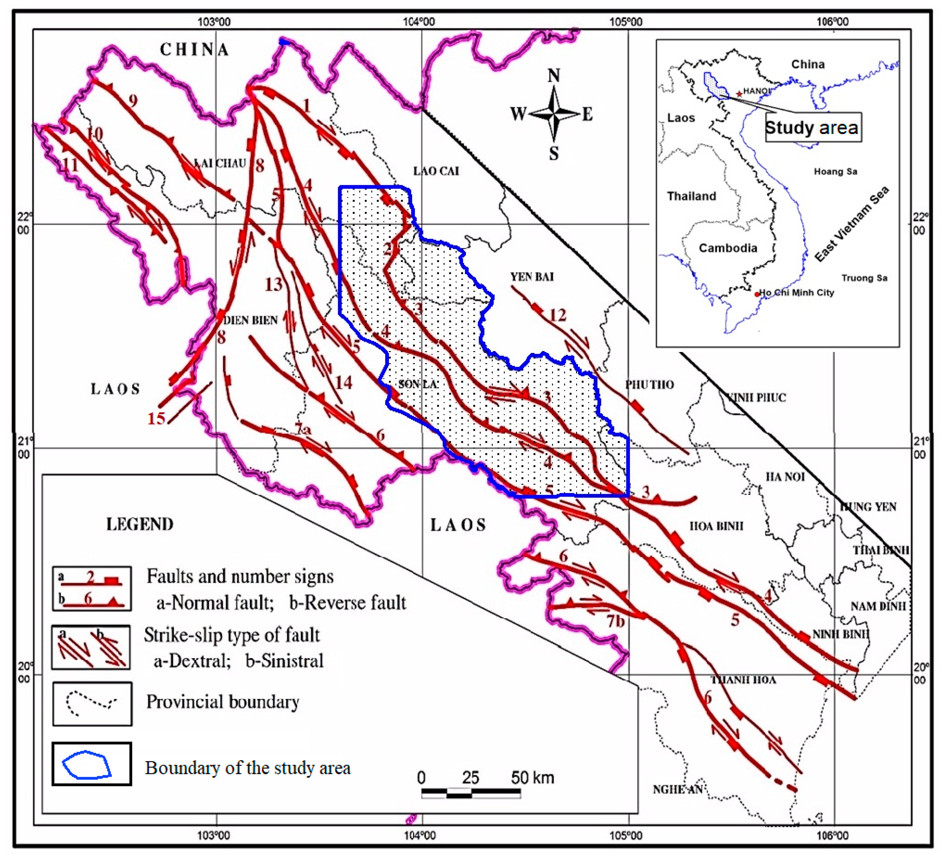
3. Database
4. Results and Discussion
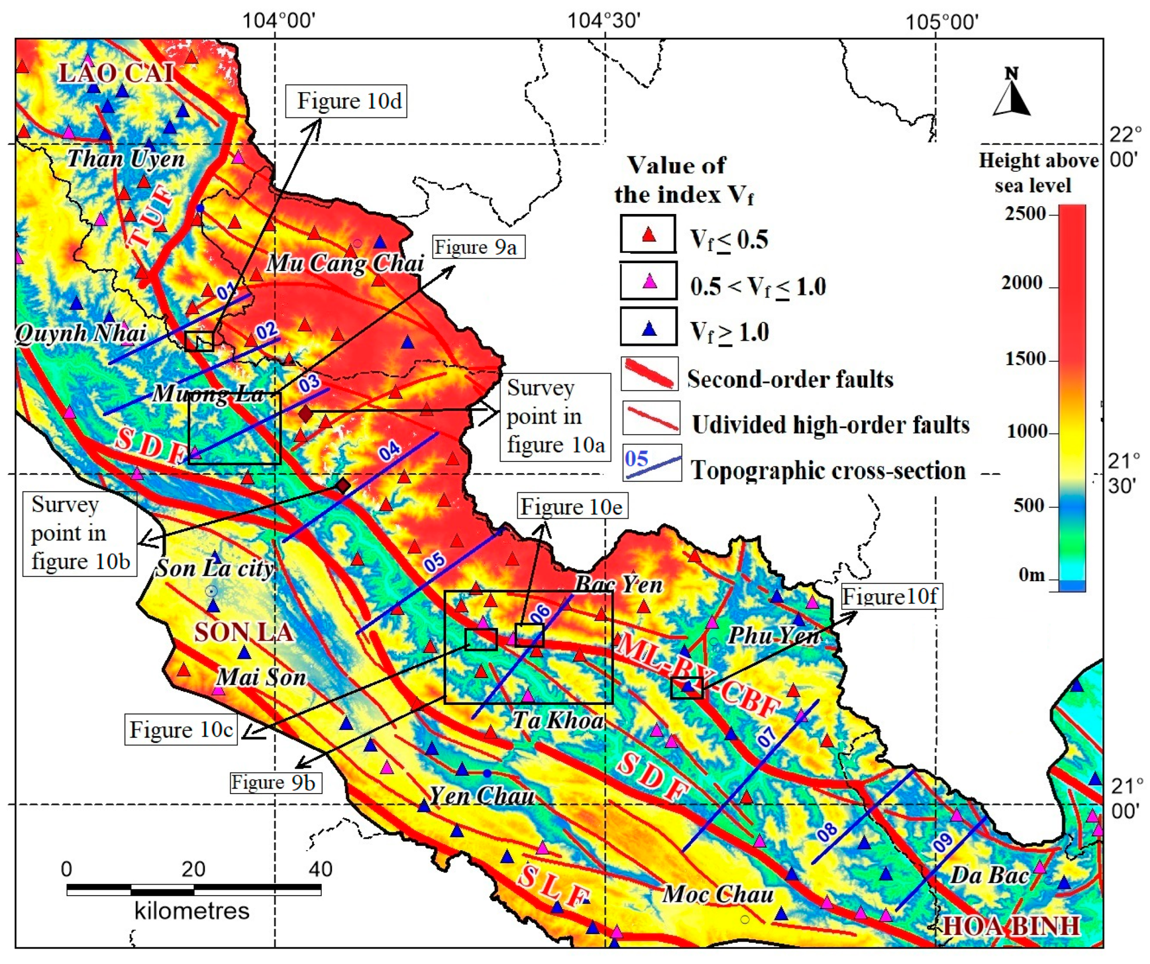
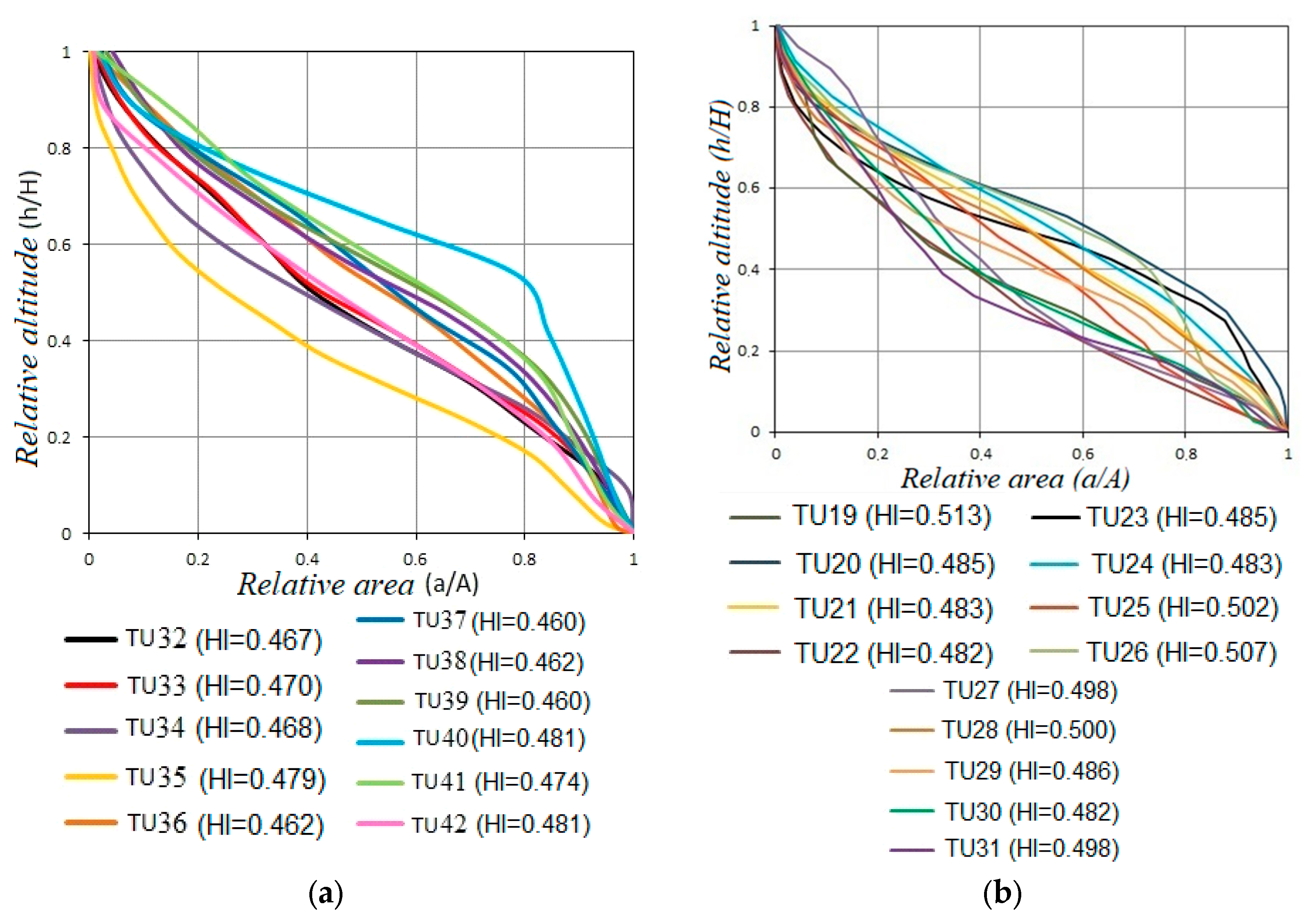
4.1. Results of Topographic and Geomorphological Analysis According to Indices
- -
- Results of Vf analysis:
- -
- Results of HC and HI analysis:
- -
- Results of Smf Index Analysis:
- -
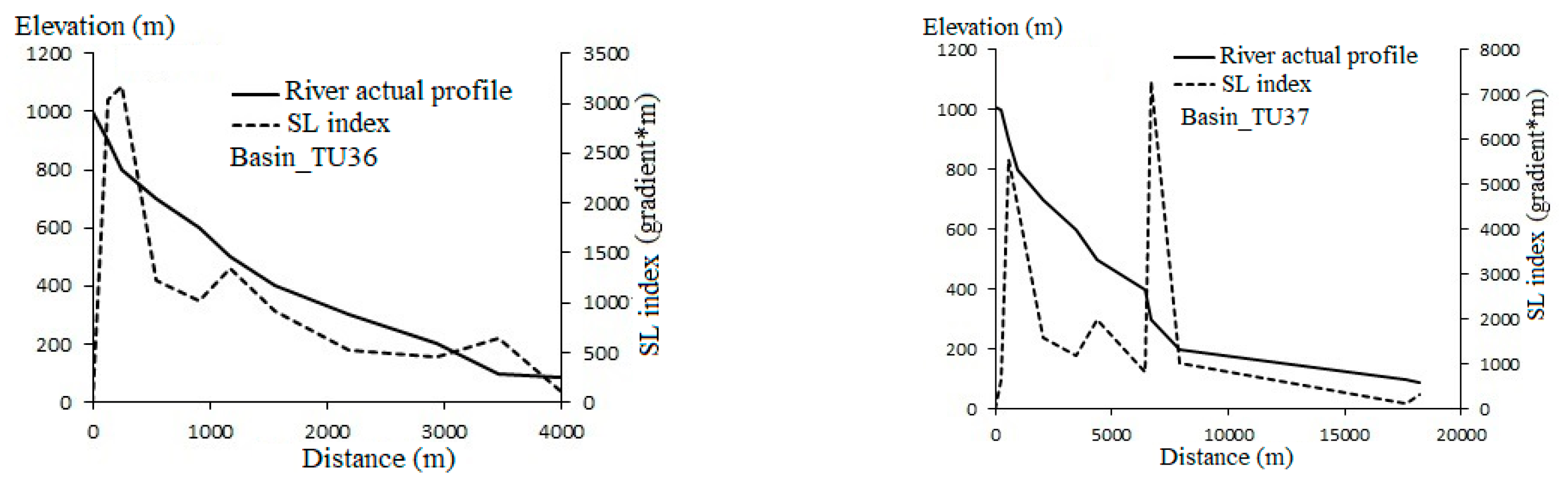
- Results of SL value analysis:
4.2. Discussion
- -
- The low Vf values, which are mostly less than 0.5, confirm the “rejuvenation” of the streams and the obvious influence of tectonic activities on the two walls of the Muong La–Bac Yen–Cho Bo fault.
- -
- The analysis of HC and HI indices shows that the neo-tectonic uplift on the right wall of the Muong La–Bac Yen–Cho Bo fault occurs more strongly than on the left wall of this fault. The HC in the study area is straight–convex shaped, and the basins on the northeast wall have a smaller HI value ranging from 0.46–0.481 and are more convex than on the southwest wall.
- -
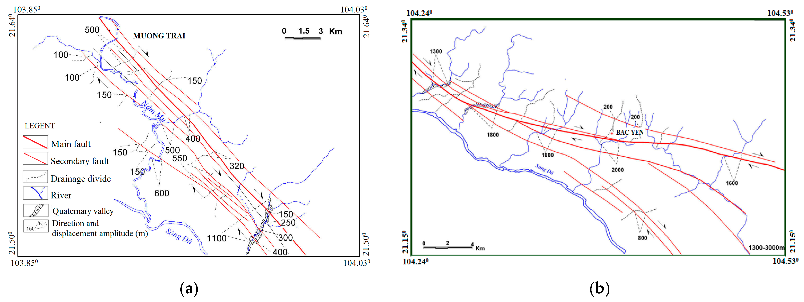
- Values of Smf segments from 1.92–3.28 along the foot slope of Hoang Lien Son range (the segment from Than Uyen to Bac Yen and Phu Yen) signify the relatively active tectonics of the ML–BY–CB fault.
- -
- The SL index and vertical profile of the streams on the northeast wall are much greater than those on the southwest wall. This reveals that the northeast wall is more actively uplifted than the southwest wall in the modern period. The SL values and vertical profile are also consistent with the HC of the tributaries, indicating that the river and stream network on the northeast wall is in the young stage of development, and deep erosion activities occur strongly, corresponding to active uplift on the northeast wall.
5. Conclusions
- -
- The ML–BY–CB fault was active during the young tectonic period, for which the segments from Than Uyen–Bac Yen show more active tectonics than the segment from Bac Yen–Da Bac.
- -
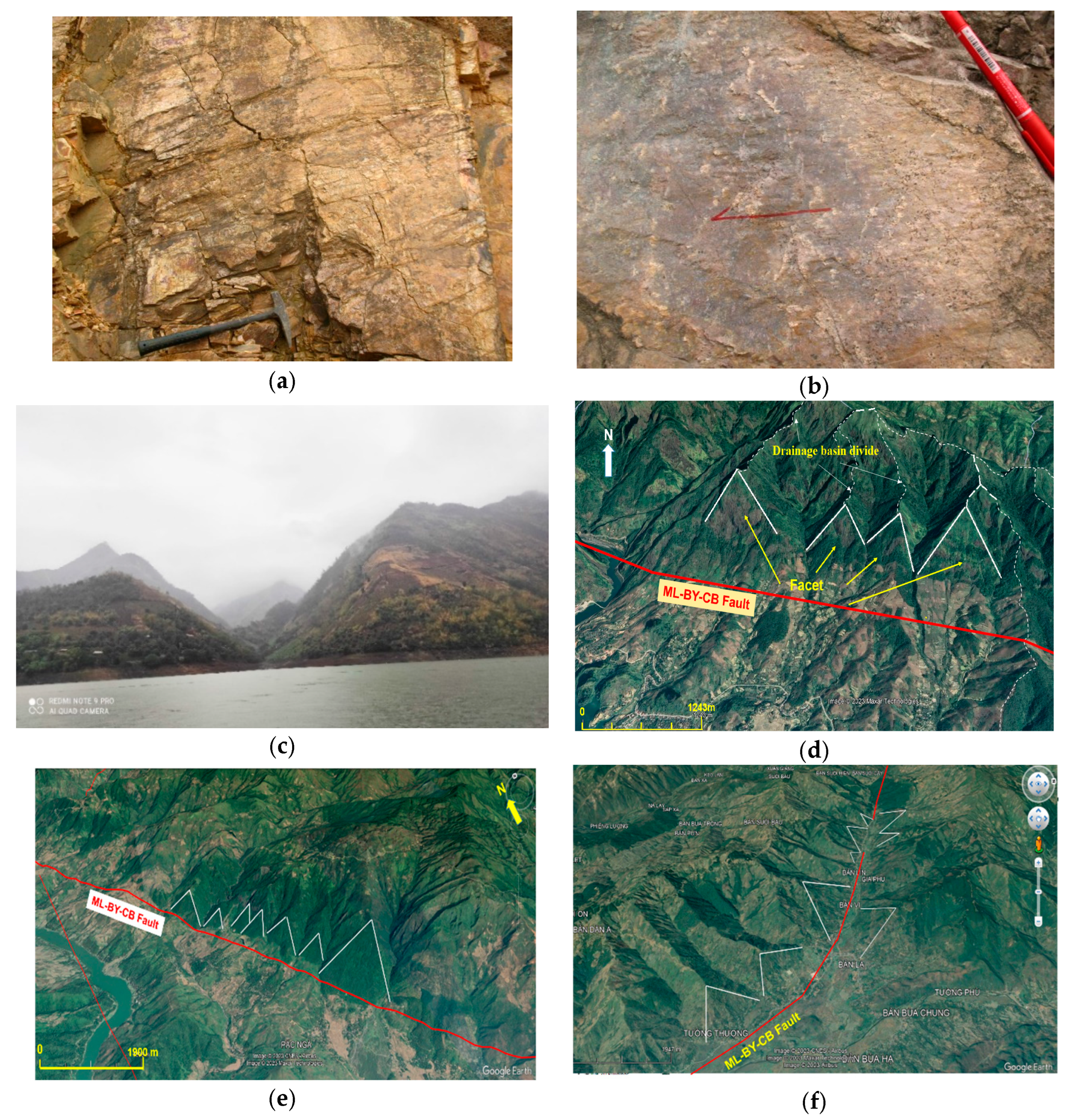
- There is an obvious differentiation between the two walls of the ML–BY–CB fault; the right wall was strongly uplifted and the left wall relatively subsided in the neo-tectonic period. Values of geomorphological indices confirm the “rejuvenation” of the streams and the influence of tectonic activities on the terrain on both walls of the fault.
- -
- Applying the method of analyzing geomorphological indices can provide reliable results for fault activity, especially strike-slip or normal strike-slip faults.
Author Contributions
Funding
Data Availability Statement
Conflicts of Interest
References
- Sissakiana, V.K.; Al-Ansarib, N.; Adamo, N. Geomorphology, Stratigraphy and Tectonics of the Mesopotamian Plain, Iraq: A Critical Review. Geotectonics 2021, 55, 135–160. [Google Scholar] [CrossRef]
- Refas, S.; Zaagane, M.; Mouassa, S.; Tamer, A.; Zehafi, B. The Geomorphologic Responses to Active Fault Propagation Fold in the Western Algerian Tell Chain: A Case Study from the Southern Part of Beni-Chougrane Mountains. Geotectonics 2022, 56, 339–360. [Google Scholar] [CrossRef]
- Gautama, P.K.; Kumar, D.; Singh, A.K.; Singh, D.S. Drainage Network Analysis and Tectonics Interference of the Reth River, Central Ganga Plain (India) Using Geospatial Technology. Geotectonics 2023, 57, 330–345. [Google Scholar] [CrossRef]
- Cuong, N.Q.; Zuchiewicz, W.A. Tectonic-geomorphological characteristics of the Tam Dao fault. Vietnam J. Earth Sci. 2001, 4, 354–361. [Google Scholar] [CrossRef]
- Liem, N.V. Segmentation of the Red River and Lo River fault zones in the Quaternary and its role in assessing seismotectonics and geohazards. In VAST-Level Scientific and Technologicalprojectof Priority Directions; Institute of Geological Sciences: Hanoi, Vietnam, 2016. [Google Scholar]
- Strahler, A. Hypsometric (area–altitude) analysis of erosional topography. Geol. Soc. Am. Bull. 1952, 63, 1117–1142. [Google Scholar] [CrossRef]
- Bull, W.B. Tectonic Geomorphology of Mountains: A New Approach to Paleoseismology; Wiley-Blackwell: Oxford, UK, 2007; 328p. [Google Scholar]
- Keller, E.A.; Pinter, N. Active Tectonics; Prentice Hall: Upper Saddle River, NJ, USA, 2002; 362p, ISBN 0-13-088230-5. [Google Scholar]
- Tuyen, N.H.; Phach, P.V.; Shakirov, R.B.; Trong, C.D.; Hung, P.N.; Anh, L.D. Geoblocks Recognition and Delineation of the Earthquake Prone Areas in the Tuan Giao Area (Northwest Vietnam). Geotectonics 2018, 52, 359–381. [Google Scholar] [CrossRef]
- Duan, B.V.; Thang, N.C.; Vuong, N.V.; Nguyen, P.D. The magnitude of the largest possible earthquake in the Muong La-Bac Yen fault zone. Vietnam J. Earth Sci. 2013, 35, 53–59. [Google Scholar] [CrossRef]
- Gholami, E.; Vaghari, P.; Khatib, M.M.; Faghih, A. Morphotectonic Analysis of Sub-Basins along the North Termination of Anar Fault, Yazd Block, Iran. Geotectonics 2023, 57, 524–538. [Google Scholar] [CrossRef]
- Topal, S. Evaluation of relative tectonic activity along the Priene-Sazlı Fault (Söke Basin, southwest Anatolia): Insights from geomorphic indices and drainage analysis. J. Mt. Sci. 2019, 16, 909–923. [Google Scholar] [CrossRef]
- Kumar, L.; Joshi, G.; Agarwal, K.K. Morphometry and Morphostructural Studies of the Parts of Gola River and Kalsa River Basins, Chanphi-Okhalkanda Region, Kumaun Lesser Himalaya, India. Geotectonics 2020, 54, 410–427. [Google Scholar] [CrossRef]
- Taesiri, V.; Pourkermani, M.; Sorbi, A.; Almasian, M.; Arian, M. Morphotectonics of Alborz Province (Iran): A Case Study Using GIS Method. Geotectonics 2020, 54, 691–704. [Google Scholar] [CrossRef]
- Mahmood, S.A.; Shahzad, M.; Batool, S.; Amer, A.; Kaukab, I.S.; Masood, A. Neotectonics from Geomorphic Indices: Highlights from Main Mantle Thrust (Pakistan). Geotectonics 2021, 55, 563–583. [Google Scholar] [CrossRef]
- Duan, B.V.; Duong, N.V. The relation between fault movement potential and seismic activity of major faults in Northwestern Vietnam. Vietnam J. Earth Sci. 2017, 39, 240–255. [Google Scholar]
- Thuy, N.N.; Chinh, V.V.; Bach, L.D.; Vuong, N.V.; Thang, T.V.; Trieu, C.D.; Phach, P.V.; Thang, N.G.; Bich, N.D.; Dy, N.D.; et al. Report on Detailed Seismic Zoning in the Northwest Region. State-Level Project KC-08-10 in the Period 2001–2005; Institute of Geophysics: Hanoi, Vietnam, 2005. [Google Scholar]
- Hung, N.V. Basic Characteristics of Neotectonic Faults in the Northwest Region. Ph.D. Thesis, Institute of Geological Sciences, Hanoi, Vietnam, 2002. [Google Scholar]
- Hung, N.V.; Vinh, H.Q.; Huong, N.V. Tectono-structural system and geodynamic features of Northwest Vietnam in the late Cenozoic period. Vietnam J. Earth Sci. 2016, 38, 38–45. [Google Scholar] [CrossRef]
- El Hamdouni, R.; Irigaray, C.; Fernández, T.; Chacón, J.; Keller, E.A. Assessment of relative active tectonics, southwest border of the Sierra Nevada (southern Spain). Geomorphology 2008, 96, 150–173. [Google Scholar] [CrossRef]
- Trinh, P.T.; Van Liem, N.; Van Huong, N.; Vinh, H.Q.; Van Thom, B.; Thao, B.T.; Tan, M.T.; Hoang, N. Late Quaternary tectonics and seismotectonics along the Red River fault zone, North Vietnam. Earth Sci. Rev. 2012, 114, 224–235. [Google Scholar] [CrossRef]
- Mahmood, S.A.; Gloaguen, R. Appraisal of active tectonics in Hindu Kush: Insights from DEM derived geomorphic indices and drainage analysis. Geosci. Front. 2012, 3, 407–428. [Google Scholar] [CrossRef]
- Pérez-Pena, J. V GIS-Based Tools and Methods for Landscape Analysis and Active Tectonic Evaluation. Ph.D. Thesis, Departamento de Geodimámica, Universidad de Granada, Granada, Spain, 2009. [Google Scholar]
- Hack, J.T. Stream-profile analysis and stream–gradient index. U.S. Geol. Surv. J. Res. 1973, 1, 421–429. [Google Scholar]
- Pérez-Pena, J.V.; Azanon, J.M. CalHypso: An ArcGIS extension to calculate hypsometric curves and their statistical moments. Applications to drainage basin analysis in SE Spain. Comput. Geosci. 2009, 35, 1214–1223. [Google Scholar] [CrossRef]
- Yen, V.; Ly, P.S.; Phu, D.B.; Bai, Y.; Binh, K.; Cai, L. Geological and Mineral Resources Map of Vietnam on 1:200,000; Geological survey of Vietnam: Hanoi, Vietnam, 1996. [Google Scholar]
- Son, L.T.; Hai, D.T.; Xuyen, N.D.; Trieu, C.D.; Phuong, N.H.; Minh, L.H.; Son, V.T.; Thang, T.; Vuong, N.V. Research on Forecasting Triggered Earthquakes in the Son La Hydropower Reservoir; Final report of independent state-level project, coded: DTDL.2009T/09; Institute of Geophysics: Ha Noi, Vietnam, 2012; 271p. [Google Scholar]
- Dung, L.V.; Trong, C.D.; Trieu, C.D.; Son, L.T.; Bach, L.D.; Van, D.Q.; Duong, N.A.; Minh, N.T.; Hung, P.N.; Bach, M.X.; et al. Research on Establishing a Network of Earthquake Monitoring Stations and Assessing Reservoir-Triggered Earthquakes on the Da River Cascade Hydropower Plant; Final Report of Independent State-Level Project, Coded: DTDLCN.27/15; Institute of Geophysics: Ha Noi, Vietnam, 2019; 304p. [Google Scholar]


| No. | Segment | Smf |
|---|---|---|
| 1 | M-17 | 2.4 |
| 2 | M-18 | 1.94 |
| 3 | M-19 | 2.314 |
| 4 | M-20 | 1.929 |
| 5 | S-19 | 2.596 |
| 6 | S-21 | 3.047 |
| 7 | U-20 | 3.285 |
Disclaimer/Publisher’s Note: The statements, opinions and data contained in all publications are solely those of the individual author(s) and contributor(s) and not of MDPI and/or the editor(s). MDPI and/or the editor(s) disclaim responsibility for any injury to people or property resulting from any ideas, methods, instructions or products referred to in the content. |
© 2025 by the authors. Licensee MDPI, Basel, Switzerland. This article is an open access article distributed under the terms and conditions of the Creative Commons Attribution (CC BY) license (https://creativecommons.org/licenses/by/4.0/).
Share and Cite
Hang, P.T.T.; Shakirov, R.; Thom, B.V.; Dung, L.V.; Syrbu, N.; Hieu, T.T.; Anh, P.T.N.; Yen, T.H.; Maltseva, E.; Kholmogorov, A.; et al. Assessment of the Tectonic Activity of the Muong La–Bac Yen–Cho Bo Fault (Northwest Vietnam) by Analysis of Geomorphological Indices. GeoHazards 2025, 6, 16. https://doi.org/10.3390/geohazards6020016
Hang PTT, Shakirov R, Thom BV, Dung LV, Syrbu N, Hieu TT, Anh PTN, Yen TH, Maltseva E, Kholmogorov A, et al. Assessment of the Tectonic Activity of the Muong La–Bac Yen–Cho Bo Fault (Northwest Vietnam) by Analysis of Geomorphological Indices. GeoHazards. 2025; 6(2):16. https://doi.org/10.3390/geohazards6020016
Chicago/Turabian StyleHang, Phung Thi Thu, Renat Shakirov, Bui Van Thom, Lê Van Dung, Nadezhda Syrbu, Tran Trung Hieu, Phung Thi Ngoc Anh, Tran Hoang Yen, Elena Maltseva, Andrey Kholmogorov, and et al. 2025. "Assessment of the Tectonic Activity of the Muong La–Bac Yen–Cho Bo Fault (Northwest Vietnam) by Analysis of Geomorphological Indices" GeoHazards 6, no. 2: 16. https://doi.org/10.3390/geohazards6020016
APA StyleHang, P. T. T., Shakirov, R., Thom, B. V., Dung, L. V., Syrbu, N., Hieu, T. T., Anh, P. T. N., Yen, T. H., Maltseva, E., Kholmogorov, A., Tuyen, N. H., & An, V. H. (2025). Assessment of the Tectonic Activity of the Muong La–Bac Yen–Cho Bo Fault (Northwest Vietnam) by Analysis of Geomorphological Indices. GeoHazards, 6(2), 16. https://doi.org/10.3390/geohazards6020016