Abstract
The Muong La–Bac Yen–Cho Bo fault is one of the seismic faults in the northwest region of Vietnam. Neo-tectonic activities and exogenous processes have influenced the drainage system and topographic–geomorphologic features on both walls of the fault. The results of topographic analysis and geomorphological indices have confirmed the active tectonics of the fault during the Neo-tectonic period (Pliocene–Quaternary, about 5 million years). The valley floor width-to-height ratio (Vf) of less than 0.5 indicates the “rejuvenation” of the streams and the obvious influence of tectonic activities on the two walls of the studied fault. The Hypsometric curve (HC) in the study area has a straight–convex shape and the basins on the northeast wall have hypsometric integral index values ranging from 0.46 to 0.481, which are lower and more convex than those of the southwest wall. The Mountain-front sinuosity index (Smf) from 1.92 to 3.28 along the foot slope of the Hoang Lien Son range (the segment from Than Uyen to Bac Yen and Phu Yen) and the highly variable stream-length gradient index (SL) value on the northeast wall signify the relative tectonic uplift on the northeast wall of the fault. The deformed geomorphological indications (steep cliffs, slip surfaces, etc.) in the field confirm the active tectonics of the Muong La–Bac Yen–Cho Bo fault during the Neo-tectonic period.
1. Introduction
Tectonic activity in general and tectonic fault activity in particular have left clear imprints on topography and geomorphology, such as straight streams, steep cliffs or slopes, gullies, meandering anomalies, river and stream networks, terrain gradation [1,2,3]. Therefore, research on topographic and geomorphological indications allows determination of the activity of young tectonic faults. In recent years, due to the assessment of the activity of studied faults and the quantitative analysis of geomorphological indices, research results have become more accurate and reliable [4,5,6,7,8,9,10]. In addition, geomorphological indices can be used to clarify evidence of tectonic activity when lacking earthquake data [3,11]. In [12], the authors used morphological parameters and determined the relationship between drainage network shape and regional tectonic activity. Many projects apply geomorphological indices to study the influence of fault activity on morphotectonics and tectonic activity in the region [3,13,14]. Thus, it can be seen that tectonic activities will greatly affect the drainage system and geomorphological features in that area. Geomorphic deformations are closely related to neo-tectonic activities [15].
In Vietnam, the assessment of the activity of tectonic faults based on the analysis of geomorphological indices has not been developed; currently, there are only some research results on segments along the Red River fault [5] and Tam Dao fault [4], which show that the methods of analyzing and determining geomorphological indices give reliable results and can be widely used. In this article, we have applied the methods of analyzing geomorphological indices to assess the tectonic activity of the Muong La–Bac Yen–Cho Bo fault (ML-BY-CB), especially in the young and modern tectonic period.
The Muong La–Bac Yen–Cho Bo fault starts from Than Uyen, extends through Muong Trai, Muong La, Ta Khoa, Bac Yen, Phu Yen, Van Yen, Cho Bo, and ends at Kim Boi–Hoa Binh, with a length of 220 km. The ML–BY–CB fault is influenced by the general tectonic activity of the Northwest structural plan (Figure 1). In the Northwest region of Vietnam, The majority of major faults extends in the northwest–southeast (NW–SE) direction, and only a small minority extends in the northeast–southwest (NE–SW) and sub-longitudinal directions. These faults have developed on the basis of ancient faults and acted as the boundaries between tectonic structural units with different movement mechanisms [16]. The Muong La–Bac Yen–Cho Bo fault also comprises sinistral dextral strike-slip. Activity characteristics of the fault in the neo-tectonic period have been studied by many authors and results published in many specialized journals [16,17,18,19,20,21]. However, studies on the neotectonics and active tectonics of the fault are lacking, partly because field research has not been carried out in many segments of the fault, besides which the assessment of the fault activity using geomorphological indices from remote sensing images is not yet available. The young tectonic phase comprises the neo-tectonic activities (starting from the Pliocene to the present) occurring from 5 Ma to the present and are recorded from signs, documents, and data in the East Sea, Vietnam. The modern tectonic phase is determined to be the tectonic processes occurring only during the Quaternary period, and even only from the Holocene to the present (recorded earthquake and volcanic activities), and the manifestations of activities determined from multi-year monitoring data. To solve the problem, the assessment of fault activity is conducted based on the analysis of geomorphological indices including ratio of valley floor width to valley height; stream length–gradient index; drainage basin asymmetry; and hypsometric curve (HC) and HI index. The results of assessment of these geomorphological indices have shed light on the young tectonic activity of this fault.
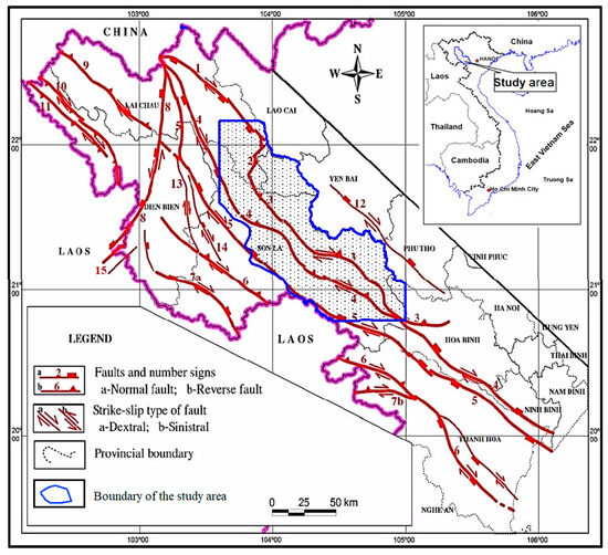
Figure 1.
Muong La–Bac Yen–Cho Bo Fault on Map of Active faults from Pliocene–present in Northwestern Vietnam [16]. Legend 1—Phong Tho, 2—Than Uyen, 3—Muong La–Bac Yen–Cho Bo, 4—Song Da, 5—Son La, 6—Ma River, 7a—Fu May Tun, 7b—Quan Son, 8—Lai Chau–Dien Bien, 9—Upper Da River, 10—Muong Toong, 11—Muong Nhe, 12—Nghia Lo–Hoa Binh, 13—Bung Lao–Da Bop, 14—Tuan Giao–Nam Ty, 15—Dien Bien–Pac Nua.
2. Research Methods
The geomorphological indices used in this paper are based on morphological analysis of drainage basin networks and allow the detection of variations in drainage basins or along mountain slopes [22]. These variations may be due to local changes from tectonic uplift or subsidence activities. The indices represent geomorphological deformations related to the erosion and deposition processes of the tectonic-originated riverbed. Calculated and analyzed geomorphological indices, including Ratio of valley floor width to valley height (Vf), Stream Length–Gradient Index (SL), Hypsometric Curve (HC) and Hypsometric Integral (HI), are applied according to [6,23].
- -
- Mountain-front sinuosity index (Smf) is used to assess tectonic activity along mountain ranges; this index also depends on climatic and lithological conditions [7,8] and is determined using the formula by Bull [7] and Keller [8] as follows:
Smf = Lmf/Ls
This index reflects the correlation between the erosional forces that lead to the formation of mountain front embayments and the tectonic forces that form straight-line mountain fronts coinciding with the active range of the fault. The closer this index is to 1, the more it shows a deep dissection and straightening of the mountain front, which means that the area has strong uplift activity. On the contrary, if it is greater than 1, it shows insignificantly deep dissection, which signifies weak uplift activity and a low stream slope in the area.
Regarding the mountain-front sinuosity index (Smf), [6,24] point out that Smf value < 1.4 represents an area with active tectonics, 1.4 < Smf < 3 characterizes an area with weaker tectonic activity and Smf > 3 is usually typical of a stable area within about 1km, compared to the current erosion surface.
- -
- The valley floor width-to-height ratio (Vf) is the ratio of valley floor width to valley height, calculated according to this formula [7,8]:
This ratio reflects the deep dissection caused by erosion (the difference in terrain elevation between the head and floor of the valley). Therefore, this ratio can be used to evaluate the deep dissection of the valley and the uplift and subsidence of the area. Deep V-shaped valleys (Vf < 1) characterize areas with active uplift; meanwhile, flat U-shaped valleys (Vf > 1) represent areas with severe erosion and quiet tectonic activity.
- -
- Hypsometric curve (HC) and hypsometric integral index (HI):
HC is the morphometric curve of the drainage basin, which is represented by the correlation graph of area-to-height ratio in selected basins [6,8]. The HC shape is related to the segmentation of the basin and allows comparison between basins of different sizes [8,22,23,24,25]. HC is a very useful tool to determine the development stages of river and stream basins. A convex HC is indicative of the terrain of a relatively young area; an S-shaped HC characterizes a moderately eroded area, and a concave HC is typical of a relatively old, highly eroded basin.
The HI value is understood as the area under the HC and varies from 0 to 1. In strongly and weakly eroded basins, HI values are close to 0 and 1, respectively. The HC and HI indices greatly depend on lithological and structural factors. Therefore, it can be seen that the HC and HI indices partly reflect the vertical profile of the basin, and the balance between the two processes of erosion and tectonic uplift–subsidence in the area:
where HI is the hypsometric integral, Hmax is maximum elevation, Hmin is minimum elevation and Hmean is mean elevation.
- -
- The stream-length gradient index (SL): The SL index is related to the energy of the stream and its sensitivity to changes in bed slope. This sensitivity allows assessment of the relation between tectonic activity, rock durability and regional topography. The SL index is defined by [24] as follows:
SL = (ΔH/ΔL)L
3. Database
To calculate, analyze and present our findings, we have applied ArcGIS technology (the tool used directly in ArcGIS is Arcmap) remote sensing data for the Northwest region: Google Earth images (analyzed with Google Earth Pro software 7.3.6.10201), ASTER GDEM digital elevation model (2023) with resolution of 30 m (source: NASA/METI/AIST/Japan Space Systems, U.S./Japan ASTER Science Team), and a 1/250,000 topographic map (Map Info and Global Mapper 15.0 software). Based on the above-mentioned technology and data, we determined 24 drainage basins (Figure 2). The selected basins are all tributary basins of the Da River and are almost located on both walls of the ML–BY–CB fault. The left and right basins are defined according to the downstream direction.
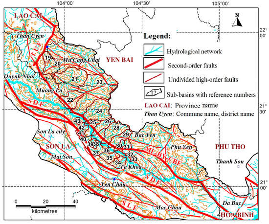
Figure 2.
Diagram of basins along the Muong La–Bac Yen–Cho Bo fault.
In the study area, Vf value is determined at 126 points along the tributary streams, almost on both walls of the fault, which do not necessarily coincide with 24 drainage basins (Figure 3). The HC–HI and SL indices are only calculated for the 24 basins determined in Figure 2. The Smf index is calculated from the digital topographic map of the study area at a scale of 1:50,000. The mountain front straight lines and foot slopes are chosen as the lowest contour lines within a range of 200 m. The locations of topographic and geomorphological cross-sections are shown in Figure 3, perpendicular or nearly perpendicular to the direction of the fault from 01–09, running from northwest to southeast of the fault.
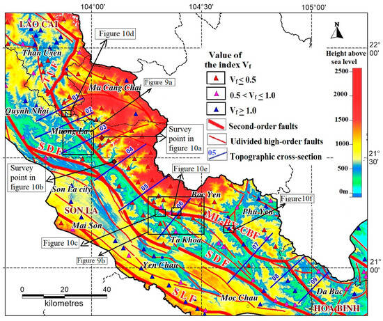
Figure 3.
Diagram of Vf index locations and survey points location of Figures 9 and 10.
4. Results and Discussion
4.1. Results of Topographic and Geomorphological Analysis According to Indices
- -
- Results of Vf analysis:
The calculation of the Vf geomorphological index reveals significant differentiation along the ML–BT–CB fault. On the right side of the fault, Vf values are predominantly low (<0.5), indicating active uplift of the topography of the east wing of the fault during the modern period. In contrast, the left side and southern segments show variable Vf values due to complex terrain dissection. The Phu Yen–Da Bac area is characterized by a block-domed tectonic-denuded mountain range, which is formed by strongly dissected metamorphic rocks and developed river and stream basins. In the west and southwest, the terrain is horizontally dissected because it is formed by strongly to moderately dissected extrusive sediments and sedimentary rocks, and consequently there are many steep to extremely steep valley walls. The Da River valley in the Muong La–Bac Yen segment is quite narrow, and the terrain on both walls is steep. Therefore, Vf values still belong to the second group (the influence of tectonic activities is at a moderate level) (Figure 3). The Vf values clearly show the active influence of tectonic activity on the terrain of the study area.
- -
- Results of HC and HI analysis:
According to calculation in the Hindu Kush area by [22], HI values from 0.37 to 0.78 were divided into three classes: class 1 (0.51–0.78), convex HC describes the young stage of the basins; class 2 (0.37–0.50), S-shaped HC characterizes the developing stage of the basins; class 3 (<0.37), concave HC and low HI value are typical of the mature and old stage of the basins. In the studies [5] conducted for the Red River, Lo River, and Chay River basins, the values are divided into five groups: (1) HI value = 0.5–0.59, corresponding to the convex HC; (2) HI value = 0.4–0.5, corresponding to the straight-convex HC; (3) HI value = 0.3–0.4, corresponding to the straight S-shaped HC; (4) HI value = 0.2–0.3, corresponding to the concave S-shaped HC; and (5) HI value < 0.2, corresponding to the concave HC.
Comparing and applying these findings to the basins in the study area, regional HI values range from 0.460 to 0.513. Compared with the values divided between the above studies, it can be seen that the HI value of the area near the ML–BY–CB fault is obviously influenced by active tectonics. The HI value suggests that the HC in the study area has a straight–convex shape. In the segment from Than Uyen–Muong La, the HI value of the basins on the right bank of the Da River is 0.46–0.481, lower than on the left bank of the Da River (HI value = 0.482–0.513) (Figure 4). The HC on the right bank is more convex than on the left bank, which indicates that the basins on the right bank are more significantly influenced by active tectonics than on the left bank, forming a severely dissected terrain. It can be seen that the right bank is under the influence of two faults, the ML–BY–CB fault and the Da River fault, which have complicated the terrain in the middle.
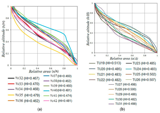
Figure 4.
Diagrams of HC and HI values of the basins of Da River in the Than Uyen–Muong La segment: (a) On the right bank; (b) On the left bank.
- -
- Results of Smf Index Analysis:
In the study area, Smf segments are calculated along the foot slope of Hoang Lien Son range (segment from Than Uyen to Bac Yen and Phu Yen), almost along the valley of the Muong La–Bac Yen–Cho Bo fault. The values of Smf segments range from 1.92 to 3.28. The values of Smf segments indicate the relatively active tectonics along the ML–BY–CB fault. The values of Smf segments show that, along the ML–BY–CB fault, tectonic activity is very clear and strong. The Smf values reflect the strong uplift of the northeastern wing of the fault. This is shown by the low Smf values at segments M17, M18, M19, M20 and the higher Smf values at the southwest wing (segments S19, S21, U20). (Figure 5, Table 1).
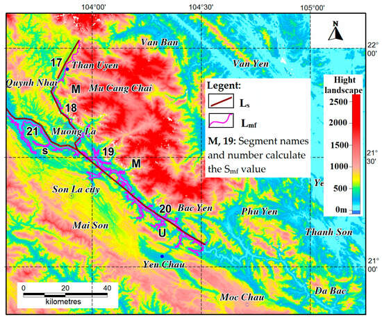
Figure 5.
Diagram of Smf index locations. Ls (its length measured along a straight line); Lmf (the length of the mountain front).

Table 1.
Segments of Smf calculation along the Muong La–Bac Yen–Cho Bo fault.
- -
- Results of SL value analysis:
Along the tributary basins of the Da River basin in the ML–BY–CB fault, 403 points for calculating SL values have been determined with a height differential of 100 m (∆H = 100 m), and the SL values are within a range from 62 to 5000 (gradient—m). SL values of tributary basins are divided into three classes according to decreasing trend of tectonic activity as follows: class 1 (SL > 700), class 2 (700 > SL > 300), class 3 (SL < 370) (Figure 6). The SL results for each tributary basin show that class 1 with high SL index is mainly concentrated in the left basin of Da River, and also on the northeast wall of the fault. This is quite consistent with the strongly dissected high mountainous terrain and steep slope in the northeast of the ML–BY–CB fault, which is obviously shown on the graphs of the relation between the vertical profile of the riverbed and the SL index (Figure 6). The riverbed profile reveals that the river and stream beds on the northeast wall are steep and the locations of high SL value are in accordance with the terrains where the slope changes suddenly. The southwest wall of the fault is relatively narrow, the terrain is complicatedly differentiated, and the terrain elevation is smaller than on the northeast wall. The vertical profile of some riverbeds in the southwest region indicates that the riverbed is gentler, therefore the SL values in this region are also much lower than in the northeast region (Figure 7 and Figure 8).
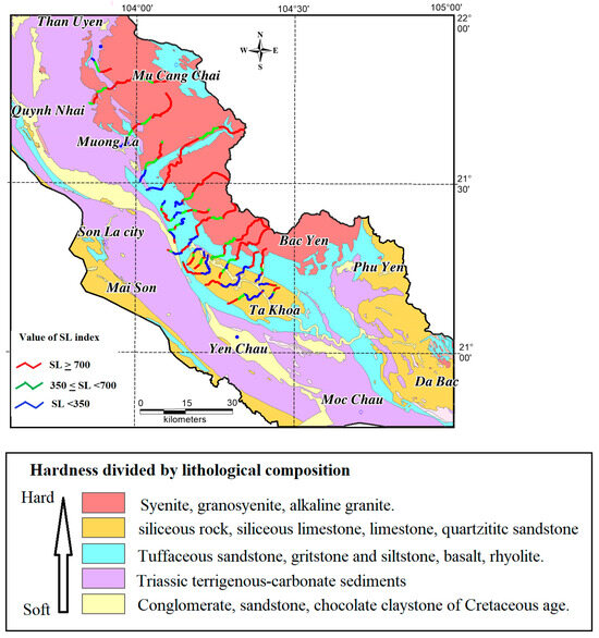
Figure 6.
Distribution diagram of SL values for lithological shear resistance in Than Uyen–Bac Yen region.
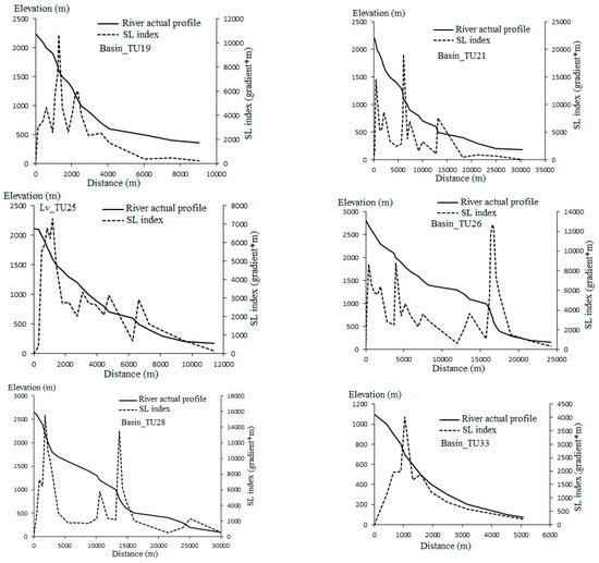
Figure 7.
River profile and SL index of some tributary basins on the northeast wall of the ML–BY–CB fault in the Than Uyen–Bac Yen region.

Figure 8.
River profile and SL index of some tributary basins on the southwest wall of the ML–BY–CB fault in the Than Uyen–Bac Yen region, Vietnam.
However, the SL value also depends on the durability and solidity of the lithological composition of the rock–soil foundation. In the study area, on the northwest wall of the fault, the lithological shear resistance (mainly the volcanic rocks of the Tu Le complex) is relatively high, which is consistent with the increase in SL values in this region. In the study area, the lithological shear resistance is divided from low to high based on the geological formations according to the method of [22], and the geological background of the study area (Geological and mineral maps of Van Yen, Phong Sa Ly–Dien Bien Phu, Yen Bai and Kim Binh–Lao Cai) [26]. Accordingly, the lowest shear resistance is in the sedimentary formations of conglomerate, sandstone, and red–brown claystone, followed by terrigenous-carbonate sediments, followed by basalt, porphyritic basalt, plagiobazan, followed by siliceous rock, siliceous limestone, and limestone, and finally by the intrusive and extrusive magmatic rocks of the Tu Le block.
4.2. Discussion
The results of analysis of the topography, geomorphology and geomorphological indices have revealed fairly distinct topographic differentiation between the two walls of the Muong La–Bac Yen–Cho Bo fault, Vietnam. In addition to the dominant local and regional tectonic activities, the geomorphological process on both walls of the fault is also influenced by topographic, climatic and lithological factors. In this article, the author will focus on analyzing the relation between geomorphological features and modern tectonic activities for the Muong La–Bac Yen–Cho Bo fault.
Physical tectonic analyses (dynamic tectonics and fracture bands) clearly show that strike-slip is dominant during the active phases of the fault, with two types of fault slip, corresponding to two stress fields belonging to two different active phases [17]. During the Cenozoic, the fault was mainly strike-slip with two phases: the sinistral slip phase occurred earlier, and the dextral slip phase occurred later [17]. Along the fault, there are many indications of geomorphological deformation due to dextral strike-slip, especially Quaternary sedimentary formations, which suggest that the dextral slip phase of the fault occurred later, and the sinistral slip phase occurred earlier (Figure 9a,b) [18]. Extensional activity and direction change for the fault are shown in the section from Bac Yen to Phu Yen in Figure 9b [21]. The nature of this fault segment changes mainly into right lateral strike-slip (Figure 10a,b) [27]. The ML–BY- BC fault passes through steep terrain, and faceted surfaces are quite well preserved in the modern terrain or narrow valleys of the tributaries of the Da River (Figure 10c–f). In addition, the uplift–subsidence activities, which differentiate the two fault walls, are also clearly shown in the modern terrain. The analysis of topographic and geomorphological cross-sections in Figure 11 also indicates the obvious differentiation between the left and right walls of the fault. The elevation of terrain surfaces on the northeast wall ranges from 1000 m to 1500 m, up to 2500 to 3000 m, much greater than on the southwest wall (only up to 1000 m).
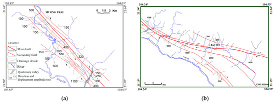
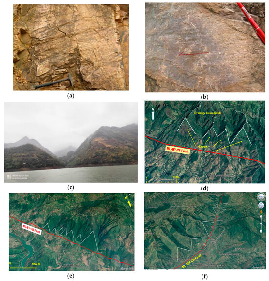
Figure 10.
Photos of surfaces: (a) Slip surface containing tectonic striations with a 70/60 position, reflecting the normal dextral slip in the Muong La–Bac Yen–Cho Bo fault [27]; (b) Slip surface containing nearly horizontal tectonic striations, reflecting the dextral slip in the Muong La–Bac Yen–Cho Bo fault [27]; (c) Terrain types of V-shaped valley in tributaries in Song Pe, Son La; (d) Faceted surfaces in Chieng Lao, Muong La, Son La, where the Muong La–Bac Yen–Cho Bo main fault passes through; (e) Faceted surfaces in Pac Nga, Bac Yen, Son La, where the Muong La–Bac Yen–Cho Bo fault passes through; (f) Faceted surfaces in the area from Bac Yen to Phu Yen, Son La, where the Muong La–Bac Yen–Cho Bo fault passes through. (The positions for Figure 10 are shown in Figure 3).
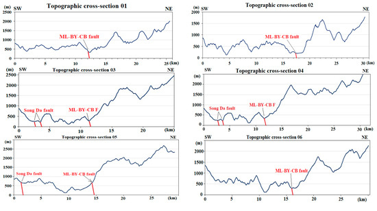
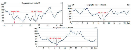
Figure 11.
Some cross-sections across the Muong La–Bac Yen–Cho Bo fault.
The results of the analysis of geomorphological indices in the above sections have indicated the active tectonic activity for the study area during the young tectonic period:
- -
- The low Vf values, which are mostly less than 0.5, confirm the “rejuvenation” of the streams and the obvious influence of tectonic activities on the two walls of the Muong La–Bac Yen–Cho Bo fault.
- -
- The analysis of HC and HI indices shows that the neo-tectonic uplift on the right wall of the Muong La–Bac Yen–Cho Bo fault occurs more strongly than on the left wall of this fault. The HC in the study area is straight–convex shaped, and the basins on the northeast wall have a smaller HI value ranging from 0.46–0.481 and are more convex than on the southwest wall.
- -
- Values of Smf segments from 1.92–3.28 along the foot slope of Hoang Lien Son range (the segment from Than Uyen to Bac Yen and Phu Yen) signify the relatively active tectonics of the ML–BY–CB fault.
- -
- The SL index and vertical profile of the streams on the northeast wall are much greater than those on the southwest wall. This reveals that the northeast wall is more actively uplifted than the southwest wall in the modern period. The SL values and vertical profile are also consistent with the HC of the tributaries, indicating that the river and stream network on the northeast wall is in the young stage of development, and deep erosion activities occur strongly, corresponding to active uplift on the northeast wall.
The ML–BY–BC fault is one of the seismic faults in the Northwest region of Vietnam. Major earthquakes have been recorded on the Muong La–Bac Yen fault: in 1991, five earthquakes were recorded, of which the largest had a magnitude of 4.7 in Ta Khoa on October 6; in 2009, the Bac Yen earthquake (Son La) had M = 3.9. The fault also acts as a boundary for tectonic–geodynamic blocks and systems and is experiencing the effects of tectonic movements in the modern period. The ML–BY–BC fault is classified as a strong earthquake-generating area with Ms = 5.5 [17], Mmax > 6.0 [28] and Mmax=5.9 + 0.3 [10].
5. Conclusions
In this study, based on the analysis of geomorphological indices, such as ratio of valley floor width to valley height (Vf), stream length–gradient index (SL), hypsometric curve (HC) and hypsometric integral (HI), as well as the results of topographic analysis of photos and in the field, we have made some conclusions regarding the modern tectonic activity of the Muong La–Bac Yen–Cho Bo fault as follows:
- -
- The ML–BY–CB fault was active during the young tectonic period, for which the segments from Than Uyen–Bac Yen show more active tectonics than the segment from Bac Yen–Da Bac.
- -
- There is an obvious differentiation between the two walls of the ML–BY–CB fault; the right wall was strongly uplifted and the left wall relatively subsided in the neo-tectonic period. Values of geomorphological indices confirm the “rejuvenation” of the streams and the influence of tectonic activities on the terrain on both walls of the fault.
- -
- Applying the method of analyzing geomorphological indices can provide reliable results for fault activity, especially strike-slip or normal strike-slip faults.
Author Contributions
Data curation, T.T.H. and E.M.; Funding acquisition, R.S.; Investigation, P.T.N.A. and A.K.; Methodology, B.V.T. and T.H.Y.; Project administration, N.S.; Resources, P.T.T.H. and L.V.D.; Visualization, N.H.T., V.H.A. and A.K.; Writing—original draft, P.T.T.H. All authors have read and agreed to the published version of the manuscript.
Funding
This paper is supported by the Selected Grassroots Science and Technology Project of the Institute of Geophysics CSCL12.02/23-24, project VAST05.01/23-24 and the state task of the POI FEB RAS No.124022100078-7. Gas–geochemical studies, as well as geomorphological studies, were funded by a Russian Science Foundation grant RSF-VAST No. 24-47-04001.
Data Availability Statement
The original contributions presented in this study are included in the article. Further inquiries can be directed to the corresponding author.
Conflicts of Interest
The authors declare no conflicts of interest.
References
- Sissakiana, V.K.; Al-Ansarib, N.; Adamo, N. Geomorphology, Stratigraphy and Tectonics of the Mesopotamian Plain, Iraq: A Critical Review. Geotectonics 2021, 55, 135–160. [Google Scholar] [CrossRef]
- Refas, S.; Zaagane, M.; Mouassa, S.; Tamer, A.; Zehafi, B. The Geomorphologic Responses to Active Fault Propagation Fold in the Western Algerian Tell Chain: A Case Study from the Southern Part of Beni-Chougrane Mountains. Geotectonics 2022, 56, 339–360. [Google Scholar] [CrossRef]
- Gautama, P.K.; Kumar, D.; Singh, A.K.; Singh, D.S. Drainage Network Analysis and Tectonics Interference of the Reth River, Central Ganga Plain (India) Using Geospatial Technology. Geotectonics 2023, 57, 330–345. [Google Scholar] [CrossRef]
- Cuong, N.Q.; Zuchiewicz, W.A. Tectonic-geomorphological characteristics of the Tam Dao fault. Vietnam J. Earth Sci. 2001, 4, 354–361. [Google Scholar] [CrossRef]
- Liem, N.V. Segmentation of the Red River and Lo River fault zones in the Quaternary and its role in assessing seismotectonics and geohazards. In VAST-Level Scientific and Technologicalprojectof Priority Directions; Institute of Geological Sciences: Hanoi, Vietnam, 2016. [Google Scholar]
- Strahler, A. Hypsometric (area–altitude) analysis of erosional topography. Geol. Soc. Am. Bull. 1952, 63, 1117–1142. [Google Scholar] [CrossRef]
- Bull, W.B. Tectonic Geomorphology of Mountains: A New Approach to Paleoseismology; Wiley-Blackwell: Oxford, UK, 2007; 328p. [Google Scholar]
- Keller, E.A.; Pinter, N. Active Tectonics; Prentice Hall: Upper Saddle River, NJ, USA, 2002; 362p, ISBN 0-13-088230-5. [Google Scholar]
- Tuyen, N.H.; Phach, P.V.; Shakirov, R.B.; Trong, C.D.; Hung, P.N.; Anh, L.D. Geoblocks Recognition and Delineation of the Earthquake Prone Areas in the Tuan Giao Area (Northwest Vietnam). Geotectonics 2018, 52, 359–381. [Google Scholar] [CrossRef]
- Duan, B.V.; Thang, N.C.; Vuong, N.V.; Nguyen, P.D. The magnitude of the largest possible earthquake in the Muong La-Bac Yen fault zone. Vietnam J. Earth Sci. 2013, 35, 53–59. [Google Scholar] [CrossRef]
- Gholami, E.; Vaghari, P.; Khatib, M.M.; Faghih, A. Morphotectonic Analysis of Sub-Basins along the North Termination of Anar Fault, Yazd Block, Iran. Geotectonics 2023, 57, 524–538. [Google Scholar] [CrossRef]
- Topal, S. Evaluation of relative tectonic activity along the Priene-Sazlı Fault (Söke Basin, southwest Anatolia): Insights from geomorphic indices and drainage analysis. J. Mt. Sci. 2019, 16, 909–923. [Google Scholar] [CrossRef]
- Kumar, L.; Joshi, G.; Agarwal, K.K. Morphometry and Morphostructural Studies of the Parts of Gola River and Kalsa River Basins, Chanphi-Okhalkanda Region, Kumaun Lesser Himalaya, India. Geotectonics 2020, 54, 410–427. [Google Scholar] [CrossRef]
- Taesiri, V.; Pourkermani, M.; Sorbi, A.; Almasian, M.; Arian, M. Morphotectonics of Alborz Province (Iran): A Case Study Using GIS Method. Geotectonics 2020, 54, 691–704. [Google Scholar] [CrossRef]
- Mahmood, S.A.; Shahzad, M.; Batool, S.; Amer, A.; Kaukab, I.S.; Masood, A. Neotectonics from Geomorphic Indices: Highlights from Main Mantle Thrust (Pakistan). Geotectonics 2021, 55, 563–583. [Google Scholar] [CrossRef]
- Duan, B.V.; Duong, N.V. The relation between fault movement potential and seismic activity of major faults in Northwestern Vietnam. Vietnam J. Earth Sci. 2017, 39, 240–255. [Google Scholar]
- Thuy, N.N.; Chinh, V.V.; Bach, L.D.; Vuong, N.V.; Thang, T.V.; Trieu, C.D.; Phach, P.V.; Thang, N.G.; Bich, N.D.; Dy, N.D.; et al. Report on Detailed Seismic Zoning in the Northwest Region. State-Level Project KC-08-10 in the Period 2001–2005; Institute of Geophysics: Hanoi, Vietnam, 2005. [Google Scholar]
- Hung, N.V. Basic Characteristics of Neotectonic Faults in the Northwest Region. Ph.D. Thesis, Institute of Geological Sciences, Hanoi, Vietnam, 2002. [Google Scholar]
- Hung, N.V.; Vinh, H.Q.; Huong, N.V. Tectono-structural system and geodynamic features of Northwest Vietnam in the late Cenozoic period. Vietnam J. Earth Sci. 2016, 38, 38–45. [Google Scholar] [CrossRef]
- El Hamdouni, R.; Irigaray, C.; Fernández, T.; Chacón, J.; Keller, E.A. Assessment of relative active tectonics, southwest border of the Sierra Nevada (southern Spain). Geomorphology 2008, 96, 150–173. [Google Scholar] [CrossRef]
- Trinh, P.T.; Van Liem, N.; Van Huong, N.; Vinh, H.Q.; Van Thom, B.; Thao, B.T.; Tan, M.T.; Hoang, N. Late Quaternary tectonics and seismotectonics along the Red River fault zone, North Vietnam. Earth Sci. Rev. 2012, 114, 224–235. [Google Scholar] [CrossRef]
- Mahmood, S.A.; Gloaguen, R. Appraisal of active tectonics in Hindu Kush: Insights from DEM derived geomorphic indices and drainage analysis. Geosci. Front. 2012, 3, 407–428. [Google Scholar] [CrossRef]
- Pérez-Pena, J. V GIS-Based Tools and Methods for Landscape Analysis and Active Tectonic Evaluation. Ph.D. Thesis, Departamento de Geodimámica, Universidad de Granada, Granada, Spain, 2009. [Google Scholar]
- Hack, J.T. Stream-profile analysis and stream–gradient index. U.S. Geol. Surv. J. Res. 1973, 1, 421–429. [Google Scholar]
- Pérez-Pena, J.V.; Azanon, J.M. CalHypso: An ArcGIS extension to calculate hypsometric curves and their statistical moments. Applications to drainage basin analysis in SE Spain. Comput. Geosci. 2009, 35, 1214–1223. [Google Scholar] [CrossRef]
- Yen, V.; Ly, P.S.; Phu, D.B.; Bai, Y.; Binh, K.; Cai, L. Geological and Mineral Resources Map of Vietnam on 1:200,000; Geological survey of Vietnam: Hanoi, Vietnam, 1996. [Google Scholar]
- Son, L.T.; Hai, D.T.; Xuyen, N.D.; Trieu, C.D.; Phuong, N.H.; Minh, L.H.; Son, V.T.; Thang, T.; Vuong, N.V. Research on Forecasting Triggered Earthquakes in the Son La Hydropower Reservoir; Final report of independent state-level project, coded: DTDL.2009T/09; Institute of Geophysics: Ha Noi, Vietnam, 2012; 271p. [Google Scholar]
- Dung, L.V.; Trong, C.D.; Trieu, C.D.; Son, L.T.; Bach, L.D.; Van, D.Q.; Duong, N.A.; Minh, N.T.; Hung, P.N.; Bach, M.X.; et al. Research on Establishing a Network of Earthquake Monitoring Stations and Assessing Reservoir-Triggered Earthquakes on the Da River Cascade Hydropower Plant; Final Report of Independent State-Level Project, Coded: DTDLCN.27/15; Institute of Geophysics: Ha Noi, Vietnam, 2019; 304p. [Google Scholar]
Disclaimer/Publisher’s Note: The statements, opinions and data contained in all publications are solely those of the individual author(s) and contributor(s) and not of MDPI and/or the editor(s). MDPI and/or the editor(s) disclaim responsibility for any injury to people or property resulting from any ideas, methods, instructions or products referred to in the content. |
© 2025 by the authors. Licensee MDPI, Basel, Switzerland. This article is an open access article distributed under the terms and conditions of the Creative Commons Attribution (CC BY) license (https://creativecommons.org/licenses/by/4.0/).